
Deutsch-Chinesische Enzyklopädie, 德汉百科
 Greece


亚里士多德(公元前384—322)是古希腊著名的科学家和哲学家。公元前384年诞生于爱琴海北岸的斯特基拉城。
亚里士多德是马其顿王室医师的儿子,从小对自然科学特别爱好,也很钻研。父亲经常教给他一些解剖和医学的知识,他有时也帮助父亲作一些外科手术。亚里士多 德17岁那年前往雅典,成为古希腊著名哲学家柏拉图(前427—前347)的大弟子,从事学习和研究长达20年之久。他好学多问,才华横溢,成绩突出,柏 拉图夸他是“学院之灵”。公元前343年,亚里士多德担任了年仅13岁的王子亚历山大的宫廷教师。公元前340年亚历山大摄政,亚里士多德回到家乡。公元 前335年他重返雅典,创办了一所吕克昂学院,独树一个新的哲学学派。由于这个学派的老师和学生,常常在花园里散步的时候讨论问题,当时人们就称它为逍遥 学派。
公元前323年夏天,亚历山大大帝从印度回师巴比伦的途中病故。从此,亚里士多德在政治上开始不得志。他决定离开雅典,离开吕克昂学院回到母亲的故地过隐居生活。公元前322年因病逝世,葬在卡尔基,终年62岁。
亚里士多德(希腊语:Αριστοτέλης,Aristotélēs,前384年6月19日—前322年3月7日),古希腊哲学家,柏拉图的学生、亚历山大大帝的老师。他的著作牵涉许多学科,包括了物理学、形而上学、诗歌(包括戏剧)、音乐、生物学、经济学、动物学、逻辑学、政治、政府、以及伦理学。和柏拉图、苏格拉底(柏拉图的老师)一起被誉为西方哲学的奠基者。亚里士多德的著作是西方哲学的第一个广泛系统,包含道德、美学、逻辑和科学、政治和形上学。
亚里士多德关于物理学的思想深刻地塑造了中世纪的学术思想,其影响力延伸到了文艺复兴时期,最终被牛顿物理学取代。在动物科学方面,他的一些意见仅在19世纪被确信是准确的。他的学术领域还包括早期关于形式逻辑理论的研究,最终这些研究在19世纪被合并到了现代形式逻辑理论里。在形而上学方面,亚里士多德的哲学和神学思想在伊斯兰教和犹太教的传统上产生了深远影响,在中世纪,它继续影响着基督教神学,尤其是天主教教会的学术传统。他的伦理学,虽然自始至终都具有深刻的影响,后来也随着新兴现代美德伦理的到来获得了新生。今天亚里士多德的哲学仍然活跃在学术研究的各个方面。在经济学方面,亚里士多德对于经济活动的分类与看法持续影响到中世纪与重农主义,直到被亚当斯密的古典经济学派取代为止。虽然亚里士多德写了许多论文和优雅的对话(西塞罗描述他的文学风格为“金河”),但是大多数人认为他的著作现已失散,只有大约三分之一的原创作品保存了下来。
Aristoteles (griechisch Ἀριστοτέλης Aristotélēs, Betonung lateinisch und deutsch: Aristóteles; * 384 v. Chr. in Stageira; † 322 v. Chr. in Chalkis auf Euböa) war ein griechischer Universalgelehrter. Er gehört zu den bekanntesten und einflussreichsten Philosophen und Naturforschern der Geschichte. Sein Lehrer war Platon, doch hat Aristoteles zahlreiche Disziplinen entweder selbst begründet oder maßgeblich beeinflusst, darunter Wissenschaftstheorie, Naturphilosophie, Logik, Biologie, Medizin, Physik, Ethik, Staatstheorie und Dichtungstheorie. Aus seinem Gedankengut entwickelte sich der Aristotelismus.
 Eurovision Song Contest,ESC

 History
 Greece

 International cities
 *European Capital of Culture
 Olympic Summer Games
 Silk road

 World Heritage

 Important port
雅典建城至今已经有5000多年的历史,公元前8世纪,爱奥尼亚人建成的雅典是古希腊城邦的盟主。古代雅典是西方文化的源泉,雅典人对艺术、哲学、法律、科学作出了杰出的贡献。公元前5世纪为雅典的鼎盛时期,出现了许多不朽的大师。大悲剧家欧里庇德斯、大喜剧家阿里斯托芬、哲学家苏格拉底、柏拉图、亚里斯多德、历史学家希罗多德等都在这里诞生或居住过,这些光辉的名字照耀着人类文化的黎明。
雅典是希腊的古文物中心,至今仍保存着很多古代文化遗址,如今仍能显出当年的雄伟气概。雅典的博物馆世界驰名。
跨越时空两千五百年正是雅典给人的感觉,山丘上的卫城是西元前五百年的伟大艺术杰作,而山下的波拉卡区千年来就是一本希腊人的生活宝库,而身为希腊的首都及最大的城市,雅典的现代化建筑,拥挤的交通和空气污染严重,又和世界一般大都会无异。
现在雅典是全世界旅游爱好者的度假胜地。蔚蓝的爱琴海边涛声依旧,雅典的一砖一砾都闪烁着人类文明的光辉。 (Quelle:http://eur.bytravel.cn)
雅典(希腊语:Αθήνα,Athína,[aˈθina];古希腊语:Άθῆναι,转写:Athēnai)是希腊首都,也是希腊最大的城市。雅典位于巴尔干半岛南端,三面环山,一面傍海,西南距爱琴海法利龙湾8公里,属亚热带地中海气候。基菲索斯河和伊利索斯河穿城而过。市内多小山。
雅典是世界上最老的城市之一,有记载的历史就长达3000多年。现在雅典是欧洲第八大城市[1]。雅典是希腊经济、财政、工业、政治和文化中心。雅典也是欧盟商业中心之一。市区人口330万,加上郊区人口共有380万人口。城市的面积为39平方公里,加上郊区为412平方公里。[2]
古雅典是一个强大的城邦,是驰名世界的文化古城。希腊是西方哲学的摇篮,是柏拉图学院和亚里士多德的讲学场所的所在地。[3][4]苏格拉底、希罗多德、伯里克利、索福克勒斯、阿里斯托芬、欧里庇得斯、埃斯库罗斯和其他著名的哲学家、政治家和文学家都在雅典诞生或居住过[5],雅典也因此被称作“西方文明的摇篮”和民主的起源地。[6]公元前5世纪和4世纪在文化和政治上的成就对欧洲及世界文化产生重大影响。[7]
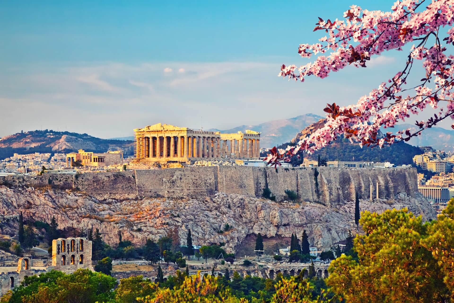
雅典至今仍保留了很多历史遗迹和大量的艺术作品,其中最著名的是雅典卫城的帕提农神庙,是西方文化的象征。
雅典是现代奥运会起源的地方。1896年曾举办过第一届夏季奥运会。2004年,第二十八届夏季奥林匹克运动会在雅典举行。Athen – neugriechisch Αθήνα [aˈθina] (f. sg.), Katharevousa und altgriechisch Ἀθῆναι Athênai (f. pl.) – ist die Hauptstadt Griechenlands. Athen ist die bevölkerungsreichste und flächengrößte Stadt des Landes. Die Gemeinde Athen im Zentrum des Ballungsraums Athen-Piräus ist dabei relativ klein. Athen im weiteren Sinne umfasst das Gebiet der Regionalbezirke Athen-Zentrum (87,3 km²), Athen-Nord (138,79 km²), Athen-Süd (68,9 km²), Athen-West (66,8 km²) und einiger umliegender Vororte mit zusammen 3,753 Mio. Einwohnern.[2]
Als kulturelles, historisches und wirtschaftliches Zentrum des Landes ist Athen auch die bedeutendste Metropole Griechenlands. Der Flughafen ist der wichtigste des Landes und der acht Kilometer vom Athener Zentrum entfernte Hafen Piräus der größte Griechenlands. Von hier und vom kleineren Rafina wird auch der Schiffsverkehr zu den zahlreichen griechischen Inseln abgefertigt. Im Schienenverkehr hat Athen nationale, jedoch keine internationale Bedeutung.
Die Stadt ist seit der Jungsteinzeit kontinuierlich besiedelt[3] und damit eine der ältesten Siedlungen und Städte Europas. 1985 wurde Athen erste Kulturhauptstadt Europas. In die Liste des Weltkulturerbes der UNESCO wurde 1987 die Akropolis und 1990 das Kloster Daphni aufgenommen.
Athen war in der klassischen Zeit Ort der attischen Polis. Die in dieser Zeit (5. Jahrhundert v. Chr.) entstandene attische Demokratie gilt als Begründerin einer auf dem Prinzip der Volkssouveränität gegründeten politischen Ordnung.
アテネ(現代ギリシア語: Αθήνα; Athína; IPA: [aˈθina]; カサレヴサ: Ἀθῆναι, Athinai; 古代ギリシア語: Ἀθῆναι, Athēnai)は、ギリシャ共和国の首都で同国最大の都市である。
アテネはアッティカ地方にあり、世界でももっとも古い都市の一つで約3,400年の歴史がある。古代のアテネであるアテナイは強力な都市国家であったことで知られる。芸術や学問、哲学の中心で、プラトンが創建したアカデメイアやアリストテレスのリュケイオン[1][2]があり、西洋文明の揺籃や民主主義の発祥地として広く言及されており[3][4]、その大部分は紀元前4-5世紀の文化的、政治的な功績により後の世紀にヨーロッパに大きな影響を与えたことは知られている。[5]今日の現代的なアテネは世界都市としてギリシャの経済、金融、産業、政治、文化生活の中心である。2008年にアテネは世界で32番目に富める都市に位置し[6]、UBSの調査では25番目に物価が高い都市[7]に位置している。
アテネ市の人口は655,780人[8](2004年は796,442人)[9]、市域面積は39 km2 (15 sq mi)[10]である。アテネの都市的地域(大アテネや大ピラエウス)は市域を超えて広がっており、人口は2011年現在3,074,160人に達し[11]、都市的地域の面積は412 km2 (159 sq mi)[10]である。ユーロスタットによれば大都市圏地域(Larger Urban Zones,LUZ) (en) の人口は欧州連合域内では7番目に大きい。
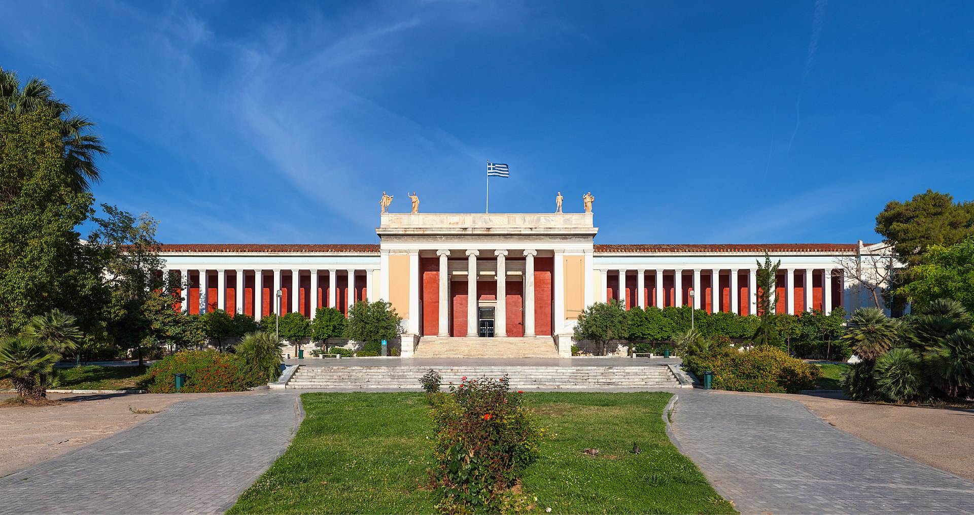
古典ギリシアの文化的遺産は今でもはっきりとしており、多くの古代遺跡や芸術作品が象徴している。もっとも有名で代表的なものにはパルテノン神殿があり初期の西洋文明の鍵となるランドマークと見なされる場合もある。アテネにはローマ帝国支配下のギリシャやビザンティンの遺跡もあり同様に少数のオスマン帝国の遺跡も残されているなど、何世紀にもわたる長い歴史を投影するモニュメントとなっている。アテネには2つのユネスコの世界遺産がありアテナイのアクロポリスと中世のダフニ修道院がそうである。現代のランドマークはギリシアが1833年に独立国となりアテネが首都に制定された時のもので、ギリシャ議会の議事堂や3部作(Trilogy )で構成されたギリシア国立図書館、アテネ大学、アテネアカデミーが含まれる。アテネは、最初の近代オリンピックであるアテネオリンピックと、その108年後に開催されたアテネオリンピック (2004年)の2度のオリンピックの舞台である。[12]アテネにはアテネ国立考古学博物館があり、世界最大の古代ギリシアの遺品の収蔵を特徴とし新しい2008年に完成したアクロポリス博物館もある。ギリシャ正教会の首長であるアテネ大主教が所在し、精神的な中心地でもある。(ギリシャ正教会は正教会に属し、クレタ島を除くギリシャ一国を管轄する。)正教会の定めるアテネの守護聖人は、ディオニシオス・オ・アレオパギティス、イェロテオス、フィロセイ。1985年には欧州文化首都に選ばれた。
Athens (/ˈæθɪnz/;[3] Greek: Αθήνα, Athína [aˈθina]; Ancient Greek: Ἀθῆναι, Athênai [a.tʰɛ̂ː.nai̯]) is the capital and largest city of Greece. Athens dominates the Attica region and is one of the world's oldest cities, with its recorded history spanning over 3,400 years[4] and its earliest human presence starting somewhere between the 11th and 7th millennium BC.[5]
Classical Athens was a powerful city-state that emerged in conjunction with the seagoing development of the port of Piraeus, which had been a distinct city prior to its 5th century BC incorporation with Athens. A centre for the arts, learning and philosophy, home of Plato's Academy and Aristotle's Lyceum,[6][7] it is widely referred to as the cradle of Western civilization and the birthplace of democracy,[8][9] largely because of its cultural and political impact on the European continent, and in particular the Romans.[10] In modern times, Athens is a large cosmopolitan metropolis and central to economic, financial, industrial, maritime, political and cultural life in Greece. In 2012, Athens was ranked the world's 39th richest city by purchasing power[11] and the 67th most expensive[12] in a UBS study.
Athens is a global city and one of the biggest economic centres in southeastern Europe. It has a large financial sector, and its port Piraeus is both the largest passenger port in Europe,[13][14][15][16] and the second largest in the world.[17][dead link] The Municipality of Athens (also City of Athens) had a population of 664,046 (in 2011)[2] within its administrative limits, and a land area of 38.96 km2 (15.04 sq mi).[18][19] The urban area of Athens (Greater Athens and Greater Piraeus) extends beyond its administrative municipal city limits, with a population of 3,090,508 (in 2011)[20] over an area of 412 km2 (159 sq mi).[19] According to Eurostat[21] in 2011, the functional urban area (FUA) of Athens was the 9th most populous FUA in the European Union (the 6th most populous capital city of the EU), with a population of 3.8 million people. Athens is also the southernmost capital on the European mainland.
The heritage of the classical era is still evident in the city, represented by ancient monuments and works of art, the most famous of all being the Parthenon, considered a key landmark of early Western civilization. The city also retains Roman and Byzantine monuments, as well as a smaller number of Ottoman monuments. Athens is home to two UNESCO World Heritage Sites, the Acropolis of Athens and the medieval Daphni Monastery. Landmarks of the modern era, dating back to the establishment of Athens as the capital of the independent Greek state in 1834, include the Hellenic Parliament and the so-called "architectural trilogy of Athens", consisting of the National Library of Greece, the National and Kapodistrian University of Athens and the Academy of Athens. Athens is also home to several museums and cultural institutions, such as the National Archeological Museum, featuring the world's largest collection of ancient Greek antiquities, the Acropolis Museum, the Museum of Cycladic Art, the Benaki Museum and the Byzantine and Christian Museum. Athens was the host city of the first modern-day Olympic Games in 1896, and 108 years later it welcomed home the 2004 Summer Olympics, making it one of only a handful of cities to have hosted the Olympics more than once.[22]
Athènes (en grec ancien Ἀθῆναι / Athễnai — le nom est toujours pluriel —, en grec moderne Αθήνα [a'θina] / Athína) est la capitale et la plus grande ville de la Grèce. En 2011, elle compte 664 046 habitants intra-muros sur une superficie de 39 km2. Son aire urbaine, le Grand Athènes, qui comprend notamment le port du Pirée, en compte plus de 3 millions. Berceau de la civilisation occidentale et dotée d'un riche passé, la ville est aujourd'hui le cœur politique, économique et culturel de la République hellénique, dont elle accueille la plupart des institutions, comme le Parlement, l'Áreios Págos (cour suprême) et le siège du Gouvernement.
Athènes est l'une des plus anciennes villes au monde, avec une présence humaine attestée dès le Néolithique. Fondée vers -800 autour de la colline de l'Acropole — par le héros Thésée, selon la légende —, la cité domine la Grèce au cours du Ier millénaire av. J.‑C.. Elle connaît son âge d'or au Ve siècle av. J.-C., sous la domination du stratège Périclès : principale puissance militaire de Grèce, à la tête d'une vaste alliance de cités, elle est également le cœur culturel de la Méditerranée. Première république de l'histoire, la démocratie athénienne connaît une vie intellectuelle importante, rassemblant des philosophes antiques (Socrate, Platon, Aristote), des auteurs de théâtre (Eschyle, Sophocle, Euripide, Aristophane) et l'historien Thucydide. De nombreux témoignages de cette période faste ont été conservés, comme le Parthénon, l'Agora (qui comprend notamment le temple d'Héphaïstos), l'Olympéion, le théâtre de Dionysos ou encore le Stade panathénaïque.
Intégrée au royaume de Macédoine, puis à l'Empire byzantin — période durant laquelle fut bâti le monastère de Daphni —, Athènes est conquise par l'Empire ottoman en 1456 et reste sous sa domination jusqu'en 1822, année de l'indépendance de la Grèce. Elle en devient la capitale et connaît une importante croissance urbaine. Occupée lors des deux guerres mondiales, la ville est ravagée par les destructions de la guerre civile grecque (1946 – 1949). Durant la seconde moitié du XXe siècle, Athènes devient le cœur économique et universitaire d'une Grèce en plein développement, dont les symboles sont les grandes avenues commerçantes telles que l'avenue Kifissias ou l'avenue Vasilissis Sofias. Frappée de plein fouet par la crise grecque depuis 2009, la ville a perdu plusieurs dizaines de milliers d'habitants et fait face à d'importantes difficultés économiques.
La ville s'étend sur la plaine d'Attique, sur les rives de la mer Égée. Elle est le chef-lieu du district régional d'Athènes-Centre et la capitale de la périphérie d'Attique, mais aussi celle du diocèse décentralisé du même nom. Le quartier le plus ancien, Pláka, est situé en contrebas de l'Acropole et comprend notamment la place Monastiráki. Kolonáki est le quartier huppé, à proximité de la place Syntagma. Enfin, Exárcheia est le quartier alternatif et branché de la ville, foyer de l'anarchisme en Grèce et de la contestation populaire depuis la crise. Grâce à son climat méditerranéen et ses nombreux musées, comme le musée de l'Acropole ou le musée national archéologique, Athènes est l'une des principales destinations touristiques d'Europe. Elle a également accueilli les Jeux olympiques d'été en 1896 et en 2004.
Atene (AFI: /aˈtɛne/[2]; in greco Αθήνα, traslitterato in Athína; in greco antico: Ἀθῆναι, Athḕnai)[3] è un comune greco di 655 780 abitanti,[1] capitale della Repubblica Ellenica, capoluogo dell'unità periferica di Atene Centrale e della periferia dell'Attica.
Il comune di Atene, stricto sensu, ha una superficie di 39 km², ma l'area metropolitana intesa come Grande Atene[4] ha un'estensione di 412 km² con 4 013 368 abitanti, ed è così la settima conurbazione più grande dell'Unione europea, e la quinta capitale più popolosa dell'Unione.[5]
Atene è una metropoli cosmopolita ed è il centro economico, finanziario, industriale e culturale della Grecia, e ha una notevole importanza a livello europeo, ma anche mondiale.[6] Nel 2012 è stata classificata come la 39ª città più ricca del mondo per potere d'acquisto[7] e come la 77ª più costosa[8] in una ricerca effettuata dalla società svizzera UBS.
È nota in tutto il mondo per la nascita della democrazia, per essere stata la sede dell'accademia di Platone e del liceo di Aristotele, oltre che aver dato i natali a Socrate, Pericle, Sofocle e molti altri filosofi e personaggi importanti dell'antichità. Tra le città più antiche del mondo,[9] è stata una fiorente polis ed è considerata la culla della civiltà occidentale.[10] Nel XXI secolo è stata al centro dell'attenzione di tutto il mondo per aver organizzato con successo i Giochi della XXVIII Olimpiade nel 2004 e per l'inaugurazione del Nuovo Museo dell'Acropoli nel 2009, che ha riaperto il dibattito riguardante i Marmi del Partenone.
Dall'aprile 2018 all'aprile 2019, Atene sarà capitale mondiale del libro.[11]
La città è anche la sede del Santo Sinodo della Chiesa di Grecia, presso il Monastero di Petraki.
Tradizionalmente la protettrice della città è la dea Atena, raffigurata sia sullo stemma che sulla bandiera della città.
Atenas (griego antiguo: Ἀθῆναι, romanización: Athēnai, griego moderno: Αθήνα, romanización: Athína) es la capital de Grecia y actualmente la ciudad más grande del país. La población del municipio de Atenas es de 664 046 (en 2011), pero su área metropolitana es mucho mayor y comprende una población de 3,8 millones (en 2011). Es el centro principal de la vida económica, cultural y política griega.
La historia de Atenas se extiende más de tres mil años, lo que la convierte en una de las ciudades habitadas más antiguas. Durante la época clásica de Grecia, fue una poderosa ciudad estado que nació junto con el desarrollo de la navegación marítima del puerto de El Pireo y que tuvo un papel fundamental en el desarrollo de la democracia. También fue un centro cultural donde vivieron muchos de los grandes artistas, escritores y filósofos de la Antigüedad. Estas contribuciones de Atenas al pensamiento de su época tuvieron una gran influencia en el desarrollo de Grecia, de Roma y de la cultura occidental.
Atenas es una ciudad rica en restos arqueológicos de extraordinaria importancia, de los cuales el más famoso es el Partenón en la Acrópolis. Además de construcciones de la época clásica griega, también se conservan monumentos romanos y bizantinos, así como varias construcciones modernas notables.
Афи́ны (греч. Αθήνα, МФА: [aˈθina]) — столица Греции. Располагается в исторической области Аттика и является экономическим, культурным и административным центром страны. Город назван в честь богини войны и мудрости Афины, которая была покровителем древнего полиса. Афины имеют богатую историю; в классический период (V век до н. э.) город-государство достигло вершины своего развития, определив многие тенденции развития позднейшей европейской культуры. Так, с городом связаны имена философов Сократа, Платона и Аристотеля, заложивших основы европейской философии, трагиков Эсхила, Софокла и Еврипида, стоявших у истоков драмы; политическим строем древних Афин была демократия.
Площадь территории городской агломерации — 412 км². Эта территория окружена горами: Эгалео, Парнис, Пенделикон и Имитос. Общая численность населения городской агломерации составляет 1/3 от общей численности населения Греции и составляет, в соответствии с переписью 2011 года, 3 090 508 человек. Таким образом плотность населения городской агломерации — 7500 человек на 1 км². Высота центра города над уровнем моря составляет 20 метров, в то время как рельеф территории города очень разнообразен, с равнинами и горами.


 Albania
 Bosnia Herzegovina
 Bulgaria
 Greece
 Kosovo
 Croatia
 Montenegro
 Nordmazedonien
 Romania
 Serbia
 Slovenia
 Turkey
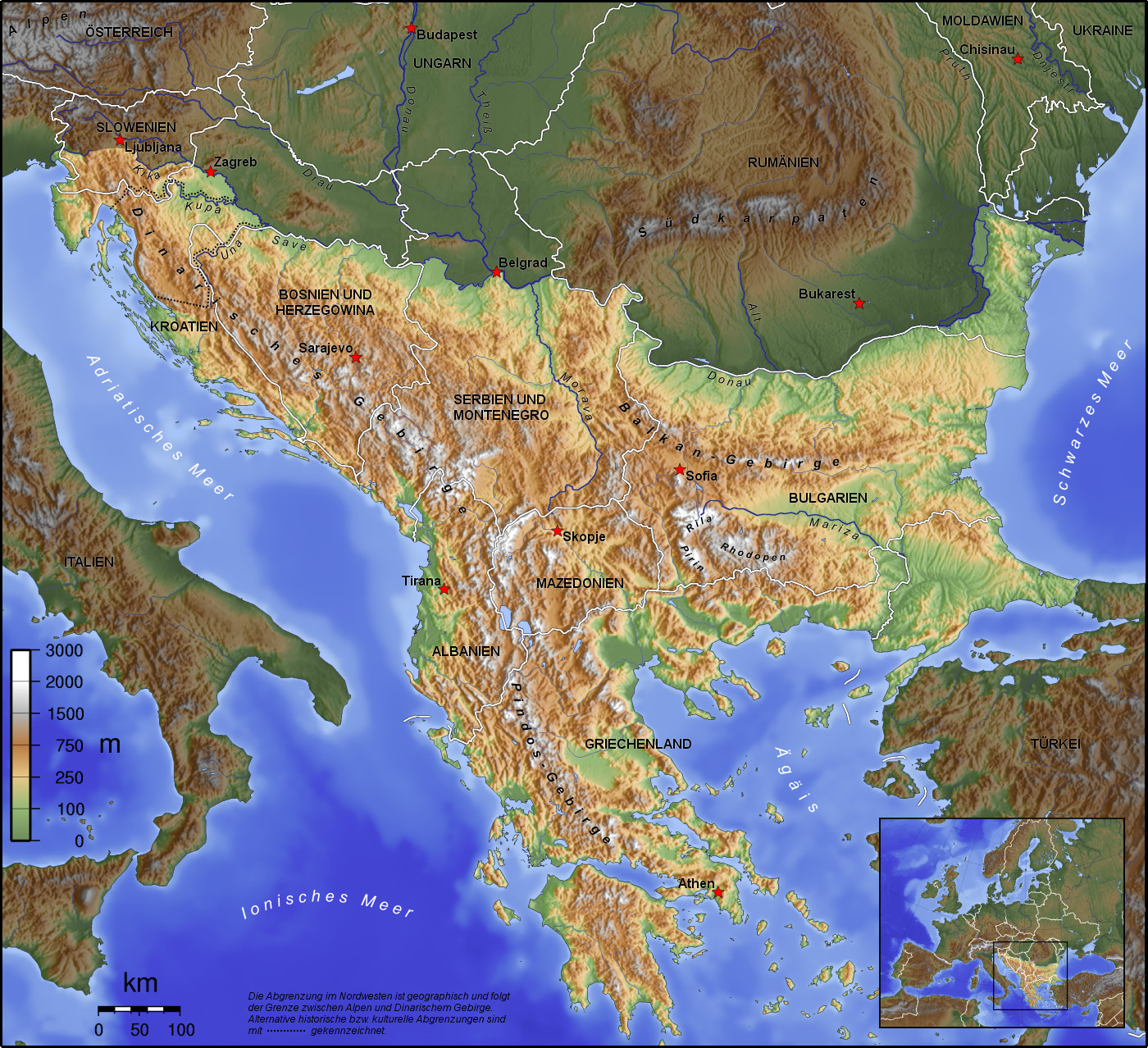
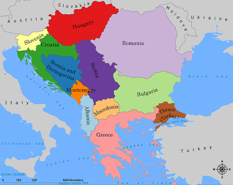
巴尔干半岛(Balkans),是一个地理名词,用以描述欧洲的东南隅位于亚得里亚海和黑海之间的陆地,详细的范围依照定义不同有许多种说法。该地约有55万平方公里和近5500万人口。在古希腊时代,巴尔干半岛被称为哈伊莫司半岛。该地区的名称来自于一条通过保加利亚中心到东塞尔维亚的巴尔干山脉。[1]
巴尔干地区向来存在诸多矛盾,其中既有宗教矛盾,也有领土争端。由于半岛的地缘政治重要性,由此而来的列强干涉致使这一地区的矛盾频繁被放大为战争,因此又有欧洲火药库之称。不过近年巴尔干半岛(南斯拉夫内战后至今)已实现停火与和平,只是偶然间在领土主权上有些纠纷,例如科索沃主权问题。第一次世界大战的触发点之——萨拉热窝事件亦是发生在巴尔干半岛上。
目前,巴尔干半岛共有11个国家,共有面积是47.6万平方公里,人口1.3亿。
南欧相邻地中海的三大半岛,从东向西分别为巴尔干半岛、意大利半岛(亚平宁半岛)、伊比利亚半岛。
半岛地处欧、亚、非三大陆之间,是欧、亚联系的陆桥,南临地中海重要航线,东有博斯普鲁斯海峡和达达尼尔海峡扼黑海的咽喉,地理位置极为重要。地形以山地为主,喀尔巴阡山以南多为山丘及石灰岩地形,以北多以为平原为主。半岛西部有迪纳拉-品都斯山脉,中东部有喀尔巴阡-老山(巴尔干)山脉。老山山脉是阿尔卑斯、喀尔巴阡山的延伸,经南斯拉夫东部,横贯保加利亚中部,直临黑海。东西两列山脉之间是古老的罗多彼山脉和马其顿山丛,最高峰穆萨拉峰,海拔2925米。半岛上平原分布零散,仅萨瓦河、多瑙河、马里查河谷较宽广。 巴尔干半岛位于欧洲东南部,三面被水环绕:西邻亚德里亚海、南面是地中海(包括爱奥尼亚海和爱琴海)和马尔马拉海、东边是黑海。其北部边界通常被定为多瑙河、萨瓦河和库帕河。[2] [3]巴尔干半岛包括49万平方公里土地。
Die Balkanhalbinsel (auch kurz Balkan, oft synonym mit Südosteuropa verwendet) ist eine geographisch nicht eindeutig definierte Halbinsel im Südosten Europas. Sie ragt in das Mittelmeer und ist nach dem Balkangebirge benannt. Der größte Staat auf der Halbinsel ist Griechenland, gefolgt von Bulgarien (in dem sich der Großteil des Balkangebirges befindet), Serbien, Bosnien und Herzegowina, Albanien, Nordmazedonien, Montenegro und dem Kosovo. Die Staatsgebiete von Serbien, Kroatien, Rumänien, Slowenien und der Türkei, die durch ihre thrakischen Provinzen Anteil am Balkan hat, reichen über die Grenzen der Balkanhalbinsel hinaus.
Ungeachtet der Herleitung des geographischen Namens sind das dominierende Gebirge des Balkans die Dinariden im westlichen Teil der Halbinsel; ihr höchster Gipfel Jezerca (2694 m) liegt in Albanien. Die höchste Erhebung des Balkans ist der Gipfel Musala (2925 m) im Rila-Gebirge. Das Balkangebirge erreicht 2376 m maximale Gipfelhöhe.
バルカン半島(バルカンはんとう、Balkan Peninsula)、またはバルカン(Balkans)は東南ヨーロッパにある地理的領域であり、地理的・歴史的に様々な意味合いと定義付け[1][2]の下で使用される概念である[3]。名称はバルカン山脈からきている。この山脈はセルビアとブルガリアの国境から黒海沿岸まで、ブルガリア全土を横断している。バルカン半島は北西をアドリア海に、南西をイオニア海に、南と南東をエーゲ海に、そして東と北東を黒海によって区切られている[4]。北側の境界は論者と文脈によって様々に定義されていて不定である。バルカン半島の最高地点はリラ山地にあるムサラ山(2925メートル)である。
バルカン半島という概念はドイツの地理学者アウグスト・ツォイネによって1808年に創り出された[5][6]。彼はバルカン山脈がディナル・アルプス山脈と共にアドリア海から黒海まで東南ヨーロッパを区分していると誤認していた[5]。この地域はかつてオスマン帝国の属領であり、バルカン半島という用語は19世紀にはヨーロッパ・トルコ(European Turkey)の同義語であった[7]。バルカン半島という言葉は地理学的というよりもむしろ地政学的定義を持っており、この傾向は20世紀初頭にユーゴスラヴィア王国が成立するとさらに増した。バルカン半島を定義する自然境界が「半島」の学術的定義と一致していないため、現代の地理学者は「バルカン半島」という考え方を拒絶しており、通常はバルカンを「地域」として議論を行っている。この言葉には徐々に、特に1990年代以降、バルカニゼーション(バルカン化)のプロセスと関連して汚名と侮蔑的意味合いが与えられており[4][8]、それ故に東南ヨーロッパ(南東ヨーロッパ)という別の用語が使用されている。
The Balkans (/ˈbɔːlkənz/ BAWL-kənz), also known as the Balkan Peninsula, is a geographic area in Southeast Europe with various geographical and historical definitions.[2][3][4] The region takes its name from the Balkan Mountains that stretch throughout the whole of Bulgaria. The Balkan Peninsula is bordered by the Adriatic Sea in the northwest, the Ionian Sea in the southwest, the Aegean Sea in the south, the Turkish Straits in the east, and the Black Sea in the northeast. The northern border of the peninsula is variously defined.[5] The highest point of the Balkans is Mount Musala, 2,925 metres (9,596 ft), in the Rila mountain range, Bulgaria.
The concept of the Balkan Peninsula was created by the German geographer August Zeune in 1808,[6] who mistakenly considered the Balkan Mountains the dominant mountain system of Southeast Europe spanning from the Adriatic Sea to the Black Sea. The term Balkan Peninsula was a synonym for Rumelia in the 19th century, the European provinces of the Ottoman Empire. It had a geopolitical rather than a geographical definition, which was further promoted during the creation of the Kingdom of Yugoslavia in the early 20th century. The definition of the Balkan Peninsula's natural borders do not coincide with the technical definition of a peninsula; hence modern geographers reject the idea of a Balkan peninsula, while historical scholars usually discuss the Balkans as a region. The term has acquired a stigmatized and pejorative meaning related to the process of Balkanization,[5][7] and hence the preferred alternative term used for the region is Southeast Europe.
Les Balkans sont une des trois « péninsules » de l'Europe du Sud, mais cette appellation traditionnelle est parfois contestée en l'absence d'un isthme : les géographes préfèrent le terme de « région ». Elle est bordée par des mers sur trois côtés : la mer Adriatique et la mer Ionienne à l'ouest, la mer Égée au sud et la mer de Marmara et la mer Noire à l'est. Au nord, on la délimite généralement par les cours du Danube, de la Save et de la Kupa. Cette région couvre une aire totale de plus de 550 000 km2 et regroupe une population de près de 53 millions d’habitants.
La penisola balcanica, nota anche come Balcani (dalla forma abbreviata di Monti Balcani, sistema montuoso tra Bulgaria e Serbia; dal turco balkan ‘monteʼ[2]), è una penisola dell'Europa orientale; è delimitata a ovest dal mare Adriatico, a sud-ovest dal mar Ionio, a est dal mar Nero, a sud-est dal mar di Marmara, e a sud dal mar Egeo.
Come spesso accade per le penisole, incerta è la definizione del suo confine sulla terraferma, aggravato dal fatto che si tratta di uno dei suoi confini più estesi. Non aiuta inoltre la definizione di questa linea di demarcazione il fatto che il territorio presenta al suo interno grandi differenze e frammentazioni per storia, nazionalità, lingua, cultura e religione delle popolazioni che vi abitano.
Solitamente se ne stabilisce il confine sul Danubio e sul suo affluente Sava. In questo modo si include in tale area anche parte della Slovenia e della Romania (paese di lingua romanza orientale), che però storicamente hanno avuto a che fare con i Balcani solo dopo la dissoluzione dell'Impero asburgico. Secondo il geografo Vittorio Vialli, la delimitazione a nord è rappresentata dalla linea geografica Istria-Odessa. Esclude dalla regione la Slovenia l'interpretazione del confine che include il fiume Kupa, facendolo partire dalla città di Fiume e raggiungendo le foci del Danubio.[3] In tal modo confina a ovest con la cosiddetta regione geografica italiana,[4][5] che include anche territori non facenti parte della Repubblica Italiana. La definizione politica di Balcani venne in uso nel XIX secolo per designare i paesi europei interessati dall'espansione e dalla successiva dissoluzione dell'Impero ottomano.[6]
Del resto le caratteristiche del territorio, solcato da catene montuose parallele che ostacolarono il movimento in direzione nord-sud e una colonizzazione uniforme già ai tempi dell'espansione greco-romana, e la sua stessa collocazione geografica contribuiscono a spiegare le tormentate vicende storiche che hanno caratterizzato la penisola.[7]
Fino al 1975 la penisola era attraversata dal Balkan Express, un treno con partenza da Vienna e arrivo a Istanbul. Il clima è continentale nel nord e nell’est del territorio (con estati calde e inverni molto rigidi), mentre l’area occidentale e la Grecia hanno un clima mediterraneo.
La península balcánica o península de los Balcanes es una de las tres grandes penínsulas del sur de Europa, continente al que está unida por los montes Balcanes al este (cordilleras que han dado nombre a la península) y los Alpes Dináricos, al oeste.
Балка́нский полуо́стров (хорв. Balkanski poluotok, словен. Balkanski polotok, серб. Балканско полуострво, рум. Peninsula Balcanică, болг. и макед. Балкански полуостров, алб. Gadishulli Ballkanik, греч. Βαλκανική χερσόνησος, тур. Balkan Yarımadası, босн. Balkansko poluostrvo, черног. Balkansko poluostrvo) расположен на юго-востоке Европы. Площадь — около 467 тыс. км².
С юга, юго-запада и юго-востока омывается: Адриатическим, Ионическим, Мраморным, Критским, Эгейским и Чёрным морями.
Северной границей полуострова считается условная линия, проведённая от устья Дуная, по рекам Дунай, Сава и Купа (Колпа), а от истока последней в Горском Котаре (Хорватия) — до залива Кварнер с портом Риека (Хорватия).
Рельеф преимущественно гористый (Стара-Планина, Родопы, Динарское нагорье, Пинд). По размерам в Европе уступает только Скандинавскому и Пиренейскому полуостровам.
 Albania
 Bosnia Herzegovina
 Bulgaria
 Greece
 Kosovo
 Croatia
 Montenegro
 Nordmazedonien
 Romania
 Serbia
 Slovenia
 Turkey
 Belgium
 Amber Road
 Denmark
 Germany
 Estonia
 France
 Greece
 Italy
Italy
 Latvia
 Lithuania
 Netherlands
 Austria
 Poland
 Russia
 Switzerland
 Slovakia
 Slovenia
 Spain
Spain
 Czech Republic
 Hungary

琥珀之路(英语:Amber Road)是一条古代运输琥珀的贸易道路,这条水路和陆路结合而成的通商道路,从欧洲北部的北海和波罗的海通往欧洲南部的地中海,连结了欧洲的多个重要城市,维持了多个世纪。
在公元前后的很长一段时间,琥珀作为装饰品中的重要组成部分,被从北海和波罗的海海岸的产地,经由维斯瓦河和第聂伯河运输到意大利、希腊、黑海和埃及。琥珀之路连结了琥珀的产地和在欧洲、中东地区和远东地区的消费地,并经由另一条通商道路丝绸之路继续通往亚洲。
Als Bernsteinstraße werden verschiedene Handelswege des Altertums (Altstraßen) bezeichnet, auf denen (unter anderem) Bernstein von der Nord- und Ostsee nach Süden in den Mittelmeerraum gelangte. Genau genommen handelt es sich nicht um eine Straße, sondern um unabhängige Handelswege, die für verschiedene Handelsgüter genutzt wurden. Die Bezeichnung „Bernsteinstraße“ tritt etwa ab dem Ende des 18. Jahrhunderts auf und hat in antiken Quellen keine Entsprechung.


 Architecture
 Museum
 Science and technology
 CESAER
 Colleges and Universities in Europe
 Music
Music
 Performing Arts
 Media and press
 Geography
 Companies
 Religion