漢德百科全書 | 汉德百科全书

       
Chinese — German
Catalog Indonesia

This image, video or audio may be copyrighted. It is used for educational purposes only. If you find it, please notify us byand we will remove it immediately.
Perusahaan Listrik Negara
http://www.net4info.de/photos/cpg/albums/userpics/10002/Perusahaan_Listrik_Negara.jpg
This image, video or audio may be copyrighted. It is used for educational purposes only. If you find it, please notify us byand we will remove it immediately.
Standort Jakarta, Indonesien Baubeginn 2014 Fertigstellung 2022 Architektonischer Autograph-Turm - 382,9 m (1.256 ft) Luminary Tower - 301,2 m (988 ft) Dachgeschoss Autograph Tower - 319,9 m (1.050 ft) Luminary Tower - 301 m (988 ft) UOB Plaza - 191,3 m (628 ft) Anzahl der Stockwerke Autograph Tower - 75 oberirdisch, 6 unterirdisch Geschossfläche 570.000 Quadratmeter Architekt(en) Kohn Pedersen Fox Bauträger PT Putragaya Wahana Tragwerksplaner Wiratman & Associates Hauptauftragnehmer PT Acset In
This image, video or audio may be copyrighted. It is used for educational purposes only. If you find it, please notify us byand we will remove it immediately.
Tokopedia

This image, video or audio may be copyrighted. It is used for educational purposes only. If you find it, please notify us byand we will remove it immediately.
Al-Akbar-Moschee
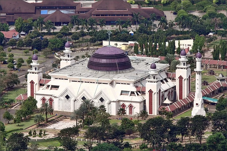
Die Al-Akbar-Nationalmoschee von Surabaya (indonesisch: Masjid Nasional Al-Akbar Surabaya), auch bekannt als Al-Akbar-Moschee (indonesisch: Masjid Al-Akbar, wörtlich. Große Moschee'; Arabisch: المسجد الأكبر; Javanisch: ꦩꦼꦱ꧀ꦗꦶꦢ꧀ꦄꦭ꧀ꦄꦏ꧀ꦧꦂ) oder Große Moschee von Surabaya, ist eine nationale Moschee in Surabaya, Ostjava. Sie ist nach der Istiqlal-Moschee in Jakarta die zweitgrößte Moschee Indonesiens, was die maximale Kapazität betrifft.

Die Al-Akbar-Nationalmoschee von Surabaya (indonesisch: Masjid Nasional Al-Akbar Surabaya), auch bekannt als Al-Akbar-Moschee (indonesisch: Masjid Al-Akbar, wörtlich. Große Moschee'; Arabisch: المسجد الأكبر; Javanisch: ꦩꦼꦱ꧀ꦗꦶꦢ꧀ꦄꦭ꧀ꦄꦏ꧀ꦧꦂ) oder Große Moschee von Surabaya, ist eine nationale Moschee in Surabaya, Ostjava. Sie ist nach der Istiqlal-Moschee in Jakarta die zweitgrößte Moschee Indonesiens, was die maximale Kapazität betrifft. Die Moschee befindet sich an der Autobahn Surabaya-Gempol. Ihr markantestes Merkmal ist ihre große vertikale Kuppel, die von vier kleinen blauen Kuppeln begleitet wird. Sie hat auch ein Minarett mit einer Höhe von 99 Metern, eine Ode an die 99 Namen Allahs.
This image, video or audio may be copyrighted. It is used for educational purposes only. If you find it, please notify us byand we will remove it immediately.
At-Tin-Moschee
Adresse: Jl. Taman Mini I No.3, RW.3, Pinang Ranti, Kec. Makasar, Kota Jakarta Timur, Daerah Khusus Ibukota Jakarta 13560, Indonesien
This image, video or audio may be copyrighted. It is used for educational purposes only. If you find it, please notify us byand we will remove it immediately.
Universität Airlangga/Airlangga University

This image, video or audio may be copyrighted. It is used for educational purposes only. If you find it, please notify us byand we will remove it immediately.
Andamanensee/Andaman Sea
安达曼海(Andaman Sea;印地语:अंडमान सागर;泰语:ทะเลอันดามัน,IPA:[tʰa.leː ʔan.daː.man]),又名缅甸海(Burma Sea;缅甸语:မြန်မာပင်လယ်,IPA:[mjəmà pìɴlɛ̀]),是一个孟加拉湾东南部的水体,位于印度洋东北,南北长约1100公里,东西宽约600公里,面积约798,000平方千米(308,100平方英里)。安达曼海的西面是印度的安达曼群岛,东面是马来半岛,北依泰国和缅甸伊洛瓦底江三角洲,东南面与著名的麻六甲海峡相连,是南中国海与印度洋间的重要水道。

Die Andamanensee (auch Andaman-SeeAndamanisches MeerHindi अंडमान सागर, birmanisch မုတ္တမ, thailändisch ทะเลอันดามัน, indonesisch und malaiisch Laut Andaman) ist ein Randmeer des östlichen Indischen Ozeans, dessen Küste von MyanmarThailandMalaysia und der indonesischen Insel Sumatra gebildet wird. Das indische Unionsterritorium der Andamanen und Nikobaren grenzt die Andamanensee im Westen zum Golf von Bengalen ab. Im Süden ist es durch die Straße von Malakka mit dem Südchinesischen Meer verbunden.

Insgesamt erstreckt sich die Andamanensee vom Flussdelta des Irrawaddy (Irawady, Ayeyarwady) im Norden über fast 1200 km bis zum Eingang der Straße von Malakka. Im Westen begrenzt durch die KokosinselnAndamanen und Nikobaren, wird sie dabei höchstens 650 km breit. Ihre Fläche beträgt 797.700 km². Die Küste von Thailand ist allein etwa 740 km lang.

Die gemessene maximale Tiefe liegt bei 4180 m. Die durchschnittliche Tiefe beträgt 870 Meter. Die Wassertemperatur an der Oberfläche schwankt leicht von 27,5 °C im Winter bis 30 °C im Sommer.

Die Andamanensee entspricht einem Backarc-Becken, das sich beim Auftreffen der Indischen Platte auf die Eurasische Platte gebildet hat. Am Meeresgrund der Andamanensee erstreckt sich in Nord-Süd-Richtung eine tektonische Bruchzone zwischen der Birma-Platte im Westen und der Sunda-Platte im Osten. Dort befinden sich mehrere Inseln vulkanischen Ursprungs. Barren Island ist die einzige darunter, welche einen aktiven Vulkan aufweist.

Am 26. Dezember 2004 wurden infolge des Sumatra-Andamanen-Bebens die Inseln und die Küsten von einem schweren Tsunami verwüstet, bei dem mindestens 230.000 Menschen ums Leben kamen.

安达曼海(Andaman Sea;印地语:अंडमान सागर;泰语:ทะเลอันดามัน,IPA:[tʰa.leː ʔan.daː.man]),又名缅甸海[3](Burma Sea;缅甸语:မြန်မာပင်လယ်,IPA:[mjəmà pìɴlɛ̀]),是一个孟加拉湾东南部的水体,位于印度洋东北,南北长约1100公里,东西宽约600公里,面积约798,000平方千米(308,100平方英里)。安达曼海的西面是印度安达曼群岛,东面是马来半岛,北依泰国缅甸伊洛瓦底江三角洲,东南面与著名的麻六甲海峡相连,是南中国海印度洋间的重要水道。

安达曼海各处水深差距极大,但是只有不到5%的海域水深超过10,000英尺(3,048米),最深处在靠近安达曼群岛的一系列海底深谷,水深超过14,500英尺(4,420米)[4]。表面水温冬季为27.5摄氏度,夏季为30摄氏度,波动很小。

在安达曼海海底沿南北走向有一道地震断层,在其西边是缅甸板块,东边是巽他板块。当地的许多岛屿是火山岛,不过目前只有一座岛上还有火山活动。

安达曼海传统上是沿岸各国渔业及货物运输的交通要道,海域内的珊瑚礁与岛屿也是热门的旅游地点。2004年12月26日发的印度洋大地震引起的严重海啸,对当地的渔业及旅游业的基础建设造成严重破坏。


This image, video or audio may be copyrighted. It is used for educational purposes only. If you find it, please notify us byand we will remove it immediately.