
漢德百科全書 | 汉德百科全书
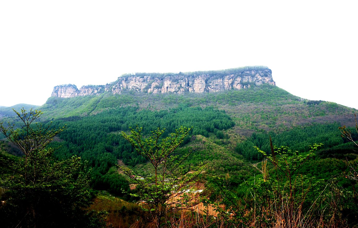
 Liaoning Sheng-LN
 History
Anhui Sheng-AH
Beijing Shi-BJ
Fujian Sheng-FJ
Gansu Sheng-GS
Guangdong Sheng-GD
Guangxi Zhuangzu Zizhiqu-GX
Guizhou Sheng-GZ
Hebei Sheng-HE
Henan Sheng-HA
Hubei Sheng-HB
Hunan Sheng-HN
Jiangsu Sheng-JS
Jiangxi Sheng-JX
Liaoning Sheng-LN
Nei Mongol Zizhiqu-NM
Ningxia Huizu Zizhiqu-NX
Qinghai Sheng-QH
Shaanxi Sheng-SN
Shandong Sheng-SD
Shanxi Sheng-SX
Sichuan Sheng-SC
Tianjin Shi-TJ
Xinjiang Uygur Zizhiqu-XJ
Zhejiang Sheng-ZJ
History
Anhui Sheng-AH
Beijing Shi-BJ
Fujian Sheng-FJ
Gansu Sheng-GS
Guangdong Sheng-GD
Guangxi Zhuangzu Zizhiqu-GX
Guizhou Sheng-GZ
Hebei Sheng-HE
Henan Sheng-HA
Hubei Sheng-HB
Hunan Sheng-HN
Jiangsu Sheng-JS
Jiangxi Sheng-JX
Liaoning Sheng-LN
Nei Mongol Zizhiqu-NM
Ningxia Huizu Zizhiqu-NX
Qinghai Sheng-QH
Shaanxi Sheng-SN
Shandong Sheng-SD
Shanxi Sheng-SX
Sichuan Sheng-SC
Tianjin Shi-TJ
Xinjiang Uygur Zizhiqu-XJ
Zhejiang Sheng-ZJ

Die Tang-Dynastie (618-907) hatte 20 Kaiser und eine Kaiserin aus 14 Generationen und war mit einer Dauer von 289 Jahren die längste Dynastie in der chinesischen Geschichte. Davon fiel fast die Hälfte der Dauer mit fast 130 Jahren auf das sogenannte Goldene Zeitalter.
Aufstieg und Entwicklung zum Goldenen Zeitalter
唐朝(618年-907年),中国历史上的朝代,国祚共历289年,21位皇帝。由唐高祖李渊所建立。唐室出身自关陇世族,先祖李虎在南北朝的西魏是八柱国之一,封为唐国公[1]:254。其后代李渊为隋朝晋阳(在今山西太原西南)留守,在隋末民变时出兵入关中以争夺天下,于618年受隋恭帝杨侑禅位,在唐朝统一战争中统一天下。唐朝定都长安(今陕西省西安市),690年到705年为武周,定都神都洛阳[2]。
唐朝历史可以概略分成数个时期,大致上以安史之乱为界。初唐时国力强盛,李渊建立唐朝,是为唐高祖,其子秦王李世民以玄武门之变,杀害兄李建成、弟李元吉,逼迫高祖内禅帝位,即为唐太宗,是唐朝多次首都兵变的开端。太宗一手将唐朝带向盛世,击败强敌东突厥,受尊为“天可汗”,成就贞观之治。唐高宗时期击败西突厥、高句丽等强敌,建立永徽之治,把唐朝版图扩到最大。高宗去世后,其皇后武后先后拥立儿子中宗和睿宗当傀儡,最后于690年废睿宗自立为皇帝,改国号曰“周”,即武周,人称“武则天”,而此时女主政治也达到高峰。直到705年中宗因神龙革命而复辟,唐朝国号得以恢复。但接着还有韦后专权,之后宗室李隆基与其姑姑太平公主共同发起唐隆之变,才扫荡韦氏势力,结束自从中宗复辟后朝政紊乱的情况。李隆基也实际掌权,成为日后的唐玄宗。玄宗即位后便发动先天之变,赐死太平公主,结束数十年来的女主政治与百年来的政变时代,进入盛唐时期,是唐朝的第二高峰与转折,开元时期唐玄宗革除前朝弊端,政治开明,威服四周国家,史称开元盛世[3]:36。到天宝时期,政治逐渐混乱,于755年爆发安史之乱,唐朝盛极而衰。中唐时,唐朝受到河朔三镇、吐蕃的侵扰、宦官专权与牛李党争等内忧外患的影响而衰退。其间虽然有唐宪宗的元和中兴、唐武宗的会昌中兴与唐宣宗的大中之治,但是都未能根治唐朝的内忧外患。在晚唐时因为政治腐败,爆发唐末民变,其中黄巢之乱破坏江南经济,使唐朝经济完全瓦解,导致全国性的藩镇割据。唐室最后被藩镇朱全忠控制,他迫使唐昭宗迁都洛阳,并于907年逼唐哀帝禅位,唐灭亡,共289年。朱全忠建国梁,史称后梁,进入五代十国时期[4]:424。
唐朝的疆域广大,但时常变动,630年就超过隋朝极盛时的版图。唐朝也是自秦汉以来,第一个不使用前朝所筑长城及不筑长城的统一王朝[5][6][7]。其鼎盛时期为7世纪,当时中亚的绿洲地带受唐朝支配。其最大范围南至罗伏州(今越南河静)、北括玄阙州(今俄罗斯安加拉河流域)、西及安息州(今乌兹别克斯坦布哈拉)、东临哥勿州(今吉林通化)的辽阔疆域[8],国土面积达1076万平方千米[9]。中唐后漠北、西域的领地相继失去,到晚唐时衰退到等同中国本部的大小,但仍然保有河套地区及河西走廊[3]:36。天宝十三年(754年)户口统计为五千二百八十八万四百八十八人[10],不过许多学者考虑到当时统计不严,存在大量没有计入统计的瞒报户口[11],此外还有隐户、佃农、奴婢、士兵、僧道等人群不纳入户口统计,故大多数学者认为唐朝人口峰值在八千万左右[12][13][14]。此时,京兆府辖区人口估算在200万人左右,而市区则是100万人[15][16][17][18][19]。
唐朝在文化、科技、政治、经济、外交等方面都达到很高的成就。在中国历史上有大量的科技发明,四大发明中的火药即诞生于唐朝、雕版印刷开始广泛应用。其政治为三省六部制,前期中央权力在皇帝与宰相,中后期宦官影响力大增。同隋朝推行科举制度,使得晋朝南朝的世族制度不再兴起,中国历史上第一个状元、三元及第,都诞生于唐朝,即622年状元孙伏伽(一说651年的颜康成)[20]。军事制度前期采用府兵制,军力强盛,多次击败外族。后期则出现节度使(藩镇)的军政制度,割据一方,到唐朝后期还出现四十八个藩镇。唐朝是当时世界的强国,与突厥、高句丽、吐蕃、大食争夺四方霸权。借由羁縻制度控制回纥、契丹等北方各族,还调度漠北地区的突厥诸部军队攻打西突厥、高句丽[21],并且让南诏、高昌、龟兹、粟特、吐蕃、新罗、渤海国和日本等国家吸收唐朝的文化与政治体制[3]:38。唐朝的经济富盛,结合华北、关中与江南的经济,到后期更加依重江南赋税。土地、盐铁与赋税制度随着社会改变而改革,由均田制与租庸调制转向两税制,并且增加许多杂税。其中两税制影响中国后半期的赋税制度[4]:424。唐朝文化兼容并蓄,接纳各个民族与宗教,进行交流融合,成为开放的国际文化[22]:126。其文学发展达到高峰,以诗最为兴盛。当时有李白、杜甫等诗人,以及推行古文运动的韩愈,其史书与传奇(小说的前身)也十分发达。由于吸收西域特征与宗教色彩,唐朝艺术与前后朝代都迥然不同,其壁画、雕刻、书法与音乐都很发达[23]:758。唐朝声誉远及海外,其历史地位深重,到明清时期海外多称中国人为“唐人”[24]。
唐(とう、拼音: 、618年 - 907年)は、中国の王朝である。李淵が隋を滅ぼして建国した。7世紀の最盛期には、中央アジアの砂漠地帯も支配する大帝国で、中央アジアや、東南アジア、北東アジア諸国、例えば朝鮮半島や渤海、日本などに、政制・文化などの面で多大な影響を与えた世界帝国である。日本の場合は遣唐使などを送り、894年(寛平6年)に菅原道真の意見でその回の遣唐使を中止し、結果としてそれ以降遣唐使は送られず、それまでは積極的な交流をしていた。首都は長安に置かれた。
690年に唐王朝は廃されて武周王朝が建てられたが、705年に武則天が失脚して唐が復活したことにより、この時代も唐の歴史に含めて叙述することが通例である。
日本では唐の滅亡後も唐、唐土の語はそれ以降の王朝、さらには外国全般を漠然と指す語として用いられた。しかし、天竺同様昔の呼称のため、正確に対応するわけではない。詳しくは中国を参照のこと。
The Tang dynasty (/tɑːŋ/;[4] Chinese: 唐朝[a]) or the Tang Empire was an imperial dynasty of China, preceded by the Sui dynasty and followed by the Five Dynasties and Ten Kingdoms period. Historians generally regard the Tang as a high point in Chinese civilization, and a golden age of cosmopolitan culture.[6] Tang territory, acquired through the military campaigns of its early rulers, rivaled that of the Han dynasty. The Tang capital at Chang'an (present-day Xi'an) was the most populous city in the world in its day.
The Lǐ family (李) founded the dynasty, seizing power during the decline and collapse of the Sui Empire. The dynasty was briefly interrupted when Empress Wu Zetian seized the throne, proclaiming the Second Zhou dynasty (690–705) and becoming the only Chinese empress regnant. In two censuses of the 7th and 8th centuries, the Tang records estimated the population by number of registered households at about 50 million people.[7][8] Yet, even when the central government was breaking down and unable to compile an accurate census of the population in the 9th century, it is estimated that the population had grown by then to about 80 million people.[9][10][b] With its large population base, the dynasty was able to raise professional and conscripted armies of hundreds of thousands of troops to contend with nomadic powers in dominating Inner Asia and the lucrative trade-routes along the Silk Road. Various kingdoms and states paid tribute to the Tang court, while the Tang also conquered or subdued several regions which it indirectly controlled through a protectorate system. Besides political hegemony, the Tang also exerted a powerful cultural influence over neighboring East Asian states such as those in Japan and Korea.
The Tang dynasty was largely a period of progress and stability in the first half of the dynasty's rule, until the An Lushan Rebellion and the decline of central authority in the later half of the dynasty. Like the previous Sui dynasty, the Tang dynasty maintained a civil-service system by recruiting scholar-officials through standardized examinations and recommendations to office. The rise of regional military governors known as jiedushi during the 9th century undermined this civil order. Chinese culture flourished and further matured during the Tang era; it is traditionally considered the greatest age for Chinese poetry.[11] Two of China's most famous poets, Li Bai and Du Fu, belonged to this age, as did many famous painters such as Han Gan, Zhang Xuan, and Zhou Fang. Scholars of this period compiled a rich variety of historical literature, as well as encyclopedias and geographical works. The adoption of the title Tängri Qaghan by the Tang Emperor Taizong in addition to his title as emperor was eastern Asia's first "simultaneous kingship".[12]
Many notable innovations occurred under the Tang, including the development of woodblock printing. Buddhism became a major influence in Chinese culture, with native Chinese sects gaining prominence. However, in the 840s the Emperor Wuzong of Tang enacted policies to persecute Buddhism, which subsequently declined in influence. Although the dynasty and central government had gone into decline by the 9th century, art and culture continued to flourish. The weakened central government largely withdrew from managing the economy, but the country's mercantile affairs stayed intact and commercial trade continued to thrive regardless. However, agrarian rebellions in the latter half of the 9th century resulted in damaging atrocities such as the Guangzhou massacre of 878–879.
La dynastie Tang (chinois : 唐朝 ; Wade : T'ang ; EFEO : T'ang, Ten quelquefois) (18 juin 618 - 1er juin 907) est une dynastie chinoise précédée par la dynastie Sui (581-618) et suivie par la période des Cinq Dynasties et des Dix Royaumes. Elle a été fondée par la famille Li, qui prit le pouvoir durant le déclin et la chute de l'empire Sui.
Venant après une longue période de division de la Chine qui dura de 220 à 581, à laquelle l'éphémère dynastie Sui avait mis fin, les premiers empereurs de cette dynastie eurent d'abord pour tâche de stabiliser l'empire récemment réunifié, et de lui redonner la puissance qu'avait eue la Chine à l'époque des Han. Ils firent rapidement mieux que ces derniers dans le domaine des conquêtes extérieures. Sous les premiers empereurs Tang (en particulier Taizong, l'impératrice Wu Zetian et Xuanzong), l'empire chinois connut une période de prospérité et un rayonnement culturel considérable. Sa capitale Chang'an, la plus grande ville du monde, reflétait toute la puissance et le cosmopolitisme, qui reposait notamment sur le dynamisme des échanges à longue distance le long de la route de la soie et des voies maritimes méridionales. Cette période a été vue par les générations suivantes comme un véritable âge d'or de la civilisation chinoise, symbolisé notamment par les brillants poètes Li Bai et Du Fu, et plus largement l'émergence d'un groupe de nombreux lettrés passés par les examens impériaux qui furent mis en place par les premiers empereurs Tang.
L'histoire de la dynastie bascula en 755 avec la révolte d'An Lushan, conséquence dramatique des évolutions politiques et militaires de l'empire à la période de son apogée. Après la difficile répression de ce soulèvement, l'organisation de l'empire se présenta sous un jour nouveau : la vieille aristocratie qui l'appuyait déclina irrémédiablement, supplantée par des hommes nouveaux disposant des charges militaires provinciales les plus importantes ou des grandes commissions fiscales et financières. Les empereurs ne parvinrent pas à contenir les forces centrifuges qui leur firent perdre l'autorité sur leurs provinces, même si cela n'entrava pas la prospérité de leur empire, portée par l'expansion démographique et économique des régions du Sud. Après une série de révoltes dans les dernières décennies du IXe siècle, la dynastie Tang s'éteint en 907, alors que son empire avait été dépecé. Les évolutions politiques, sociales, économiques et intellectuelles de cette période avaient déjà fait pénétrer la Chine dans une période que les historiens considèrent couramment comme « moderne », annonciatrice de la période de la dynastie Song (960-1272) qui réunifia la Chine quelques décennies après la fin des Tang.
Plusieurs innovations importantes sont apparues durant la dynastie Tang, dont le développement des caractères d'imprimerie en bois. Dans le domaine religieux, le bouddhisme eut une influence majeure dans la culture chinoise, avec l'affirmation de sectes bouddhistes aux racines spécifiquement chinoises et le développement d'un art remarquable. Toutefois, cette religion fut par la suite persécutée et son influence déclina, tandis que le taoïsme conservait une grande importance et que s'amorçait le retour du confucianisme, porté par les écrits de Han Yu.
La dinastia Tang (唐朝T, TángcháoP, 618-907) seguì la dinastia Sui, che aveva riportato l'unità politica in Cina, e fu seguita da un'epoca di disunione nota come il periodo delle Cinque dinastie e dieci regni.
Gli effetti del suddetto consolidamento iniziano a notarsi sotto l'imperatore Tai Zong (627 – 649), che ristabilisce il protettorato cinese sulla regione del bacino del Tarim (Asia centrale). Egli unisce la casa imperiale del Tibet alla Cina tramite matrimonio, intraprende la conquista della Corea e mantiene relazioni con il Giappone e i reami del Funan e del Champa. Con l'imperatore Xuan Zong (713 – 756) la Cina conosce un periodo di pace e prosperità, che favorisce il fiorire di produzioni artistiche.
La dinastía Tang (chino simplificado y tradicional: 唐朝, pinyin: Táng Cháo, Wade-Giles: T'ang2 Ch'ao2; ![]() tʰɑ̌ŋ tʂʰɑ̌ʊ̯ (?·i)) (618-907) fue la sucesora de la dinastía Sui y predecesora del período de las Cinco Dinastías y los Diez Reinos en China. La dinastía fue interrumpida por la segunda dinastía Zhou (690-705), cuando la emperatriz Wu Zetian usurpó el trono y fundó su propia dinastía. La dinastía Tang, con su capital en Chang'an (actual Xi'an), la ciudad más poblada del mundo en ese entonces, está considerada por los historiadores como un momento de esplendor de la civilización china, igual —o incluso superior— al del período Han.
tʰɑ̌ŋ tʂʰɑ̌ʊ̯ (?·i)) (618-907) fue la sucesora de la dinastía Sui y predecesora del período de las Cinco Dinastías y los Diez Reinos en China. La dinastía fue interrumpida por la segunda dinastía Zhou (690-705), cuando la emperatriz Wu Zetian usurpó el trono y fundó su propia dinastía. La dinastía Tang, con su capital en Chang'an (actual Xi'an), la ciudad más poblada del mundo en ese entonces, está considerada por los historiadores como un momento de esplendor de la civilización china, igual —o incluso superior— al del período Han.
Эпоха Тан (Династия Ли 李) (18 июня 618 — 4 июня 907, кит. 唐朝, Танчао) — китайская императорская династия, основанная Ли Юанем. Его сын, император Ли Шиминь, после окончательного подавления крестьянских восстаний и сепаратистских феодальных сил начал проводить прогрессивную политику. Именно эпоха Тан традиционно считается в Китае периодом наивысшего могущества страны, когда она опережала остальные современные ей страны мира в своём развитии.
 International cities
 Vacation and Travel

 Geography

 Music charts
Hebei Sheng-HE
Heilongjiang Sheng-HL
Jilin Sheng-JL
Liaoning Sheng-LN
Music charts
Hebei Sheng-HE
Heilongjiang Sheng-HL
Jilin Sheng-JL
Liaoning Sheng-LN
 Music
Music
 *Art Songs
Music
Nei Mongol Zizhiqu-NM
*Art Songs
Music
Nei Mongol Zizhiqu-NM

 World Heritage
 Architecture
 Transport and traffic
Beijing Shi-BJ
Belarus
Transport and traffic
Beijing Shi-BJ
Belarus
 Berlin
 Brandenburg
 Bremen
China
Germany
France
Gansu Sheng-GS
Hebei Sheng-HE
Heilongjiang Sheng-HL
Henan Sheng-HA
Hubei Sheng-HB
Hunan Sheng-HN
Iran
Italy
Jiangsu Sheng-JS
Jilin Sheng-JL
Kasachstan
Liaoning Sheng-LN
Nei Mongol Zizhiqu-NM
Netherlands
Bremen
China
Germany
France
Gansu Sheng-GS
Hebei Sheng-HE
Heilongjiang Sheng-HL
Henan Sheng-HA
Hubei Sheng-HB
Hunan Sheng-HN
Iran
Italy
Jiangsu Sheng-JS
Jilin Sheng-JL
Kasachstan
Liaoning Sheng-LN
Nei Mongol Zizhiqu-NM
Netherlands
 Lower Saxony
Ningxia Huizu Zizhiqu-NX
Lower Saxony
Ningxia Huizu Zizhiqu-NX
 North Rhine-Westphalia
Poland
Portugal
Russia
North Rhine-Westphalia
Poland
Portugal
Russia
 Saxony
 Schleswig-Holstein
Shaanxi Sheng-SN
Shandong Sheng-SD
Shanxi Sheng-SX
Sichuan Sheng-SC
Spain
Turkey
Turkmenistan
Uzbekistan
United Kingdom
Xinjiang Uygur Zizhiqu-XJ
Zhejiang Sheng-ZJ
Schleswig-Holstein
Shaanxi Sheng-SN
Shandong Sheng-SD
Shanxi Sheng-SX
Sichuan Sheng-SC
Spain
Turkey
Turkmenistan
Uzbekistan
United Kingdom
Xinjiang Uygur Zizhiqu-XJ
Zhejiang Sheng-ZJ
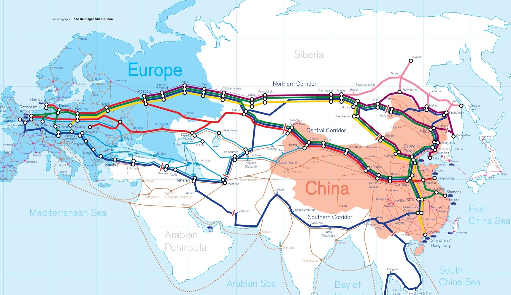
Die Neue eurasische Kontinentalbrücke (chinesisch 新亚欧大陆桥, Pinyin Xīn Yà-Ōu Dàlù Qiáo, englisch New Eurasian Continental Bridge), die auch Zweite eurasische Kontinentalbrücke (第二亚欧大陆桥, Dì'èr Yà-Ōu Dàlù Qiáo, englisch Second Eurasian Continental Bridge) genannt wird, ist eine 10.870 Kilometer[1] lange Eisenbahnverbindung, die Rotterdam in Europa mit der ostchinesischen Hafenstadt Lianyungang in der Provinz Jiangsu verbindet.
Sie besteht seit 1990 und führt durch die Dsungarische Pforte (Grenzbahnhof Alashankou). Die Lan-Xin-Bahn (chinesisch 兰新铁路, Pinyin Lán-Xīn Tiělù), also die Strecke von Lanzhou nach Ürümqi (in Xinjiang), ist ein Teil von ihr.
Es gibt eine nördliche, mittlere und südliche Route.[2] Die mittlere Strecke verläuft durch Kasachstan über Dostyk, Aqtogai, Astana, Samara, Smolensk, Brest, Warschau, Berlin zum Hafen von Rotterdam.[3] Vom slowakischen Košice soll auch eine Abzweigung in den Großraum Wien führen, siehe Breitspurstrecke Košice–Wien.
亚欧大陆桥,或新世纪亚欧大陆桥,是在中国大陆的新闻报道中经常出现的一个词语,特指从中国东部的沿海港口(有时特指连云港),沿陇海铁路、兰新铁路、北疆铁路,通过中亚、西亚到达欧洲的铁路路线。这条铁路在中国境外的具体走向,并没有任何官方文件精确指明,一说是经哈萨克斯坦、乌兹别克斯坦、土库曼斯坦、伊朗到达土耳其;一说是经俄罗斯、白俄罗斯、波兰、德国到达荷兰鹿特丹。全长10,800.32公里,1990年9月12日贯通。
The New Eurasian Land Bridge, also called the Second or New Eurasian Continental Bridge, is the southern branch of the Eurasian Land Bridge rail links running through China. The Eurasian Land Bridge is the overland rail link between Asia and Europe.
Due to a break-of-gauge between standard gauge used in China and the Russian gauge used in the former Soviet Union countries, containers must be physically transferred from Chinese to Kazakh railway cars at Dostyk on the Chinese-Kazakh border and again at the Belarus-Poland border where the standard gauge used in western Europe begins. This is done with truck-mounted cranes.[1] Chinese media often states that the New Eurasian Land/Continental Bridge extends from Lianyungang to Rotterdam, a distance of 11,870 kilometres (7,380 mi). The exact route used to connect the two cities is not always specified in Chinese media reports, but appears to usually refer to the route which passes through Kazakhstan.
All rail freight from China across the Eurasian Land Bridge must pass north of the Caspian Sea through Russia at some point. A proposed alternative would pass through Turkey and Bulgaria,[2] but any route south of the Caspian Sea must pass through Iran.[1]
Kazakhstan's President Nursultan Nazarbayev urged Eurasian and Chinese leaders at the 18th Shanghai Cooperation Organisation to construct the Eurasian high-speed railway (EHSRW) following a Beijing-Astana-Moscow-Berlin.[3]
The Eurasian Land Bridge (Russian: Евразийский сухопутный мост, Yevraziyskiy sukhoputniy most), sometimes called the New Silk Road (Новый шёлковый путь, Noviy shyolkoviy put'), or Belt and Road Initiative is the rail transport route for moving freight and passengers overland between Pacific seaports in the Russian Far East and China and seaports in Europe. The route, a transcontinental railroad and rail land bridge, currently comprises the Trans-Siberian Railway, which runs through Russia and is sometimes called the Northern East-West Corridor, and the New Eurasian Land Bridge or Second Eurasian Continental Bridge, running through China and Kazakhstan. As of November 2007, about 1% of the $600 billion in goods shipped from Asia to Europe each year were delivered by inland transport routes.[1]
Completed in 1916, the Trans-Siberian connects Moscow with Russian Pacific seaports such as Vladivostok. From the 1960s until the early 1990s the railway served as the primary land bridge between Asia and Europe, until several factors caused the use of the railway for transcontinental freight to dwindle. One factor is that the railways of the former Soviet Union use a wider rail gauge than most of the rest of Europe as well as China. Recently, however, the Trans-Siberian has regained ground as a viable land route between the two continents.[why?]
China's rail system had long linked to the Trans-Siberian via northeastern China and Mongolia. In 1990 China added a link between its rail system and the Trans-Siberian via Kazakhstan. China calls its uninterrupted rail link between the port city of Lianyungang and Kazakhstan the New Eurasian Land Bridge or Second Eurasian Continental Bridge. In addition to Kazakhstan, the railways connect with other countries in Central Asia and the Middle East, including Iran. With the October 2013 completion of the rail link across the Bosphorus under the Marmaray project the New Eurasian Land Bridge now theoretically connects to Europe via Central and South Asia.
Proposed expansion of the Eurasian Land Bridge includes construction of a railway across Kazakhstan that is the same gauge as Chinese railways, rail links to India, Burma, Thailand, Malaysia and elsewhere in Southeast Asia, construction of a rail tunnel and highway bridge across the Bering Strait to connect the Trans-Siberian to the North American rail system, and construction of a rail tunnel between South Korea and Japan. The United Nations has proposed further expansion of the Eurasian Land Bridge, including the Trans-Asian Railway project.
El Nuevo Puente de Tierra de Eurasia es también llamado el Segundo o Nuevo Puente Continental de Eurasia. Es la rama meridional de las conexiones ferroviarias del Puente de Tierra de Eurasia (también conocido como "Nueva Ruta de la Seda") que se extienden a través de la República Popular China, atravesando Kazajistán, Rusia y Bielorrusia. El Puente de Tierra de Eurasia es el enlace ferroviario terrestre entre Asia Oriental y Europa.
La Nueva Ruta de la Seda (en ruso, Новый шёлковый путь, Noviy shyolkoviy put), o Puente Terrestre Euroasiático, es la ruta de transporte ferroviario para el movimiento de tren de mercancías y tren de pasajeros por tierra entre los puertos del Pacífico, en el Lejano Oriente ruso y chino y los puertos marítimos en Europa.
La ruta, un ferrocarril transcontinental y puente terrestre, actualmente comprende el ferrocarril Transiberiano, que se extiende a través de Rusia, y el nuevo puente de tierra de Eurasia o segundo puente continental de Eurasia, que discurre a través de China y Kazajistán, también se van a construir carreteras entre las ciudades de la ruta. A partir de noviembre de 2007, aproximadamente el 1% de los 600 millones de dólares en bienes enviados desde Asia a Europa cada año se entregaron por vías de transporte terrestre.1
Terminado en 1916, el tren Transiberiano conecta Moscú con el lejano puerto de Vladivostok en el océano Pacífico, el más largo del mundo en el Lejano Oriente e importante puerto del Pacífico. Desde la década de 1960 hasta principios de 1990 el ferrocarril sirvió como el principal puente terrestre entre Asia y Europa, hasta que varios factores hicieron que el uso de la vía férrea transcontinental para el transporte de carga disminuyese.
Un factor es que los ferrocarriles de la Unión Soviética utilizan un ancho de vía más ancho en los rieles que la mayor parte del resto de Europa y China, y el transporte en barcos de carga por el canal de Suez en Egipto, construido por Inglaterra. El sistema ferroviario de China se une al Transiberiano en el noreste de China y Mongolia. En 1990 China añadió un enlace entre su sistema ferroviario y el Transiberiano a través de Kazajistán. China denomina a su enlace ferroviario ininterrumpido entre la ciudad portuaria de Lianyungang y Kazajistán como el «Puente terrestre de Nueva Eurasia» o «Segundo puente continental Euroasiático». Además de Kazajistán, los ferrocarriles conectan con otros países de Asia Central y Oriente Medio, incluyendo a Irán. Con la finalización en octubre de 2013 de la línea ferroviaria a través del Bósforo en el marco del proyecto Marmaray el puente de tierra de Nueva Eurasia conecta ahora teóricamente a Europa a través de Asia Central y del Sur.
La propuesta de ampliación del Puente Terrestre Euroasiático incluye la construcción de un ferrocarril a través de Kazajistán con el mismo ancho de vía que los ferrocarriles chinos, enlaces ferroviarios a la India, Birmania, Tailandia, Malasia y otros países del sudeste asiático, la construcción de un túnel ferroviario y un puente de carretera a través del estrecho de Bering para conectar el Transiberiano al sistema ferroviario de América del Norte, y la construcción de un túnel ferroviario entre Corea del Sur y Japón. Las Naciones Unidas ha propuesto una mayor expansión del Puente Terrestre Euroasiático, incluyendo el proyecto del ferrocarril transasiático.
Новый шёлковый путь (Евразийский сухопутный мост — концепция новой паневразийской (в перспективе — межконтинентальной) транспортной системы, продвигаемой Китаем, в сотрудничестве с Казахстаном, Россией и другими странами, для перемещения грузов и пассажиров по суше из Китая в страны Европы. Транспортный маршрут включает трансконтинентальную железную дорогу — Транссибирскую магистраль, которая проходит через Россию и второй Евразийский континентальный мост[en], проходящий через Казахстан[1]. Поезда по этому самому длинному в мире грузовому железнодорожному маршруту из Китая в Германию будут идти 15 дней, что в 2 раза быстрее, чем по морскому маршруту через Суэцкий канал[2].
Идея Нового шёлкового пути основывается на историческом примере древнего Великого шёлкового пути, действовавшего со II в. до н. э. и бывшего одним из важнейших торговых маршрутов в древности и в средние века. Современный НШП является важнейшей частью стратегии развития Китая в современном мире — Новый шёлковый путь не только должен выстроить самые удобные и быстрые транзитные маршруты через центр Евразии, но и усилить экономическое развитие внутренних регионов Китая и соседних стран, а также создать новые рынки для китайских товаров (по состоянию на ноябрь 2007 года, около 1 % от товаров на 600 млрд долл. из Азии в Европу ежегодно доставлялись наземным транспортом[3]).
Китай продвигает проект «Нового шёлкового пути» не просто как возрождение древнего Шёлкового пути, транспортного маршрута между Востоком и Западом, но как масштабное преобразование всей торгово-экономической модели Евразии, и в первую очередь — Центральной и Средней Азии. Китайцы называют эту концепцию — «один пояс — один путь». Она включает в себя множество инфраструктурных проектов, которые должны в итоге опоясать всю планету. Проект всемирной системы транспортных коридоров соединяет Австралию и Индонезию, всю Центральную и Восточную Азию, Ближний Восток, Европу, Африку и через Латинскую Америку выходит к США. Среди проектов в рамках НШП планируются железные дороги и шоссе, морские и воздушные пути, трубопроводы и линии электропередач, и вся сопутствующая инфраструктура. По самым скромным оценкам, НШП втянет в свою орбиту 4,4 миллиарда человек — более половины населения Земли[4].
Предполагаемое расширение Евразийского сухопутного моста включает в себя строительство железнодорожных путей от трансконтинентальных линий в Иран, Индию, Мьянму, Таиланд, Пакистан, Непал, Афганистан и Малайзию, в другие регионы Юго-Восточной Азии и Закавказья (Азербайджан, Грузия). Маршрут включает тоннель Мармарай под проливом Босфор, паромные переправы через Каспийское море (Азербайджан-Иран-Туркменистан-Казахстан) и коридор Север-Юг.Организация Объединенных Наций предложила дальнейшее расширение Евразийского сухопутного моста, в том числе проекта Трансазиатской железной дороги (фактически существует уже в 2 вариантах).
Для развития инфраструктурных проектов в странах вдоль Нового шёлкового пути и Морского Шёлкового пути и с целью содействия сбыту китайской продукции в декабре 2014 года был создан инвестиционный Фонд Шёлкового пути[5].
8 мая 2015 года было подписано совместное заявление Президента РФ В. Путина и Председателя КНР Си Цзиньпина о сотрудничестве России и Китая, в рамках ЕАЭС и трансевразийского торгово-инфраструктурного проекта экономического пояса «Шёлковый путь». 13 июня 2015 года был запущен самый длинный в мире грузовой железнодорожный маршрут Харбин — Гамбург (Германия), через территорию России.

 Art
Art
 Traditions


Der Yalu (deutsch auch Jalu, in Nordkorea Amnokkang genannt) ist ein Grenzfluss zwischen der Volksrepublik China und Nordkorea.
Er entspringt auf 2500 m Seehöhe am Paektu-san im Changbai-Gebirge und fließt nach 813 km zwischen den Städten Dandong (China) und Sinŭiju (Nordkorea) in das Gelbe Meer. Die wichtigsten Zuflüsse des Yalu sind der Changjin-gang, der Hŏch’ŏn-gang und der Tongro-gang.
In Sup’ung-Rodongjagu (水豊勞動者區) am Yalu, stromaufwärts von Sinŭiju, wurde die Supung-Talsperre mit einem der größten asiatischen Wasserkraftwerke errichtet. Die Staumauer ist 160 m hoch und über 850 m lang. Da das Kraftwerk in einem Grenzfluss gebaut wurde, wird es von beiden Staaten gemeinsam betrieben. Der Unterlauf des Yalu ist schiffbar. Im Bereich der Mündung des Yalu befinden sich u. a. die Inseln Hwanggŭmp’yŏng und Pidan-sŏm.
鸭绿江(朝鲜语:압록강/鴨綠江 Amnokkang */?满语:ᠶᠠᠯᡠ ᡠᠯᠠ Yalu ula;汉语拼音:Yālù jiāng),是位于中华人民共和国和朝鲜民主主义人民共和国之间的一条界江。入海口地区,朝方岛屿——绸缎岛和薪岛等与中方陆地接壤,因此鸭绿江江面末段完全在朝方一侧。目前河口为双方共用。 古称?水,汉朝称为马訾水,唐朝始称鸭绿江(隋唐时期?水为大同江),因其江水清澈,关于鸭绿江其名的来历主要流行着两种说法:一说因江水颜色似鸭头之色而得名(唐朝杜佑《通典》);二说因上游地区有鸭江和绿江两条支流汇入,故合而为一,并称为“鸭绿江”。另有源自于满族先民的语言(满语称为Yalu ula,意为“边界之江”)的说法。史书记载建州卫女真常年生活在婆猪江畔(鸭绿江支流)。鸭绿江发源于中国吉林省东南,中朝边境长白山主峰南麓海拔2300米处的长白山天池,然后流向西南,流经吉林省的长白朝鲜族自治县、临江市、集安市、辽宁省的丹东市,在辽宁省丹东市东港附近入黄海北部的西朝鲜湾。鸭绿江入海口是中国大陆海岸线的最北端。全长795公里,其中流经吉林省境界长575公里,辽宁省220公里;流域面积6.19万平方公里,中国境内流域面积约为3.25万平方公里。
鴨緑江(おうりょくこう、おうりょっこう、北京語:Yālù Jiāng、満州語:ᠶᠠᠯᡠ
ᡤᡳᠶᠠᠩ、 転写:yalu giyang[2]、朝鮮語:압록강)は、中華人民共和国(中国)東北部と朝鮮民主主義人民共和国(北朝鮮)との国境となっている川である。白頭山(中国名:長白山)に源を発し黄海に注ぐ。水の色が鴨の頭の色に似ていると言われたことからこの名前がある。
北岸は中国吉林省・遼寧省、南岸は北朝鮮慈江道・両江道・平安北道となっている。川沿いの主な都市としては、中国側に臨江、集安、丹東があり、北朝鮮側に慈城、満浦、楚山、新義州がある。
主な支流は赴戦江、長津江、虚川江で、いずれも北朝鮮側の蓋馬高原から北流して鴨緑江に合流しており、日本統治時代に大型ダムが建設されている。中国側からの支流には愛河などがある。
鴨緑江に架けられている橋の中では、下流の新義州と丹東を結ぶ中朝友誼橋が最もよく知られている。
流域では林業が盛んで、かつては上流部で伐採された木材を筏にして流していた。1930年代後半から1940年代初頭にかけて、日本によって中流域に竣工当時アジア最大級の水豊ダムが建設され、水力発電が行われるようになった。ここで生産される電力は、現在でも北朝鮮の重要なエネルギー源となっている。
The Yalu River, also called by Koreans the Amrok River or Amnok River, is a river on the border between North Korea and China. Together with the Tumen River to its east, and a small portion of Paektu Mountain, the Yalu forms the border between North Korea and China.
Two theories are given regarding the origin of the river's name. One theory is that the name derived from Yalu ula (ᠶᠠᠯᡠ
ᡠᠯᠠ) in the Manchu language. The Manchu word yalu (ᠶᠠᠯᡠ) means "the boundary between two countries". In Mandarin Chinese, yālù phonetically approximates the original Manchu word, but literally means "duck green", which was said to have been once the color of the river. The other theory is that the river was named after the combination of its two upper branches, which were called "鴨" (Yā or Ap) and "綠" (Lù or R(or n)ok)", respectively.
Revised Romanization of Korean spelled it Amnokgang (Korean pronunciation: [amnok.k͈aŋ]; "Amnok River") and Revised Romanization of Hangeul spelled it Aprokgang (Korean pronunciation: [amnok.k͈aŋ]; "Aprok River").
From 2500 m above sea level on Paektu Mountain on the China–North Korea border, the river flows south to Hyesan before sweeping 130 km northwest to Linjiang and then returning to a more southerly route for a further 300 km to empty into the Korea Bay between Dandong (China) and Sinuiju (North Korea). The bordering Chinese provinces are Jilin and Liaoning.
The river is 795 kilometers (494 mi) long and receives water from over 30,000 km² of land. The Yalu's most significant tributaries are the Changjin (장진강; 長津江), the Hochon (허천강; 虛川江), the Togro (독로강; 禿魯江) rivers from Korea and the Ai (or Aihe) (璦河) and the Hun (浑江) from China. The river is not easily navigable for most of its length.[1] Most of the river freezes during winter and can be crossed on foot.[2]
The depth of the Yalu River varies from some of the more shallow parts on the eastern side in Hyesan (1 meter (3 ft 3 in)) to the deeper parts of the river near the Yellow Sea (2.5 meters (8 ft 2 in)).[3] The estuary is the site of the Amrok River estuary Important Bird Area, identified as such by BirdLife International.[4]
About 205 islands are on the Yalu. A 1962 border treaty between North Korea and China split the islands according to which ethnic group was living on each island. North Korea possesses 127 and China 78. Due to the division criteria, some islands such as Hwanggumpyong Island belong to North Korea, but abut the Chinese side of the river.
Le Yalu (chinois simplifié : 鸭绿江 ; chinois traditionnel : 鴨綠江 ; pinyin : ), ou Amnok (en coréen : 압록강), est un fleuve qui marque la frontière entre la Chine et la Corée du Nord.
Il naît sur le Mont Paektu, point culminant de toute la Corée, à 2 500 m d'altitude et se jette dans la mer Jaune, après un parcours de 800 km orienté globalement vers le Sud-Ouest. Son bassin versant a une superficie de 30 000 km2.
Ses principaux affluents sont le Hunjiang (446 km), le Pushi et le Ai He (182 km) côté chinois ainsi que le Changjin, le Hochon et le Tongro côté coréen.
Trois barrages servent à l'approvisionnement en électricité : les barrages de Supung (765 MW), Yunfeng (400 MW) et Taipingwan.
Plusieurs ponts permettent de franchir le fleuve, dont les plus importants sont le Pont cassé du Yalu, détruit par les Américains pendant la Guerre de Corée et le pont de l'amitié sino-coréenne, qui lui est parallèle.
Il fiume Yalu (in cinese: 鴨綠江T, 鸭绿江S, Yālù JiāngP) o, in coreano, fiume Amnok (압록강?, 鴨綠江?, AmnokkangMR) forma parte del confine fra la Cina e la Corea del Nord. I due nomi in cinese e coreano sono le diverse pronunce degli stessi caratteri cinesi rappresentanti la parola Yalu ula in mancese. La sorgente si trova a circa 2500 m sul mare sulla montagna Baitou nei monti Changbai. Dopo circa 800 km il fiume sfocia nella Baia di Corea fra le città di Dandong in Cina e Sinŭiju nella Corea del Nord. Il bacino dello Yalu misura circa 39,800 km²[1].
El río Yalu o Yalú (en chino, 鸭绿江; Amrok-gang en Corea del Norte y Amnok-gang en Corea del Sur,압록강) es un río fronterizo entre China y Corea del Norte. El nombre chino proviene de una palabra manchú que significa «el límite entre dos campos».
Nace a 2500 metros sobre el nivel del mar en Paektu-san en las montañas de Changbai y fluye a lo largo de aproximadamente 800 kilómetros (según las fuentes, entre 813 y 790 km) desembocando entre las ciudades de Dandong (China) y Sinuiju (Corea del Norte), en el mar Amarillo. Los afluentes más importantes del Yalu son los ríos Changjin, Hŏch'ŏn y Tongro.
Ялуцзя́н (кит. 鸭绿江), Амноккан[1] (кор. 압록강?, 鴨綠江?, в старой русской географической литературе Амнокга́нг) — река на востоке Евразии, определяющая юго-западную часть границы между КНР и КНДР — на правом берегу располагается провинции КНР Ляонин и Гирин, на левом — провинции КНДР Пхёнан-Пукто и Чагандо.