
Deutsch-Chinesische Enzyklopädie, 德汉百科
 France

尼姆竞技场(Arènes de Nîmes)是一座古罗马圆形竞技场,位于法国城市尼姆。它大约建成于公元70年,1863年改建为斗牛场。尼姆竞技场每年举行两次斗牛,也用于其他公共活动。
这座建筑为椭圆形,长133米,宽101米。设有34排座位,能容纳16300名观众的能力,1989年以后设有可移动的屋顶和供热系统。
尼姆竞技场兴建于皇帝奥古斯都时期。罗马帝国衰落后,竞技场由西哥特人设防,四周筑起围墙。在其后的西哥特人势力崩溃后,进入动荡不安的时期,后来穆斯林曾经入侵。18世纪初被法国国王征服,尼姆子爵在竞技场内建造设防的宫殿。后来在此范围内发展成一个小社区,有100名常住居民和两个小教堂,在最高峰时竞技场内曾经生活700人。
这些建筑物一直留在竞技场内,直到18世纪,当时决定将竞技场改为目前的形式。
Die Arènes de Nîmes ist ein römisches Amphitheater in der französischen Stadt Nîmes.
In Nîmes, der colonia Nemausus in der Provinz Gallia Narbonensis des Römischen Reichs, wurde das Amphitheater zwischen 90 und 120 n. Chr. nach Vorbild des römischen Kolosseums erbaut. Während der Völkerwanderung diente es als Fluchtburg. 1863 wurde es in eine Stierkampfarena umgewandelt und heute finden dort auch andere Veranstaltungen statt.
 France

 History
 J 0 - 500 AD

 Music
Music
 Music Hall, State Theater, Opera House

 Provence-Alpes-Côte d´Azur

 World Heritage
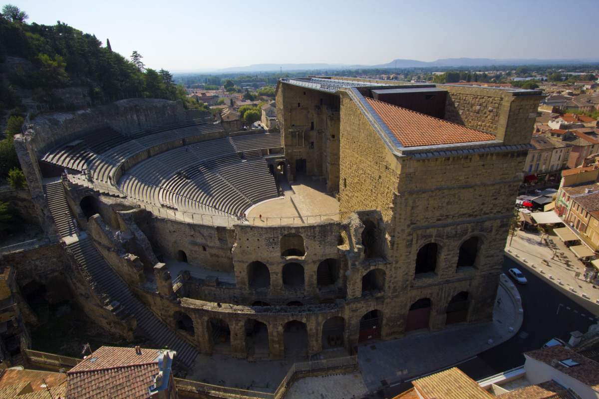
Das Theater von Orange, ein antikes römisches Theater in Südostfrankreich, wurde im 1. Jahrhundert n. Chr. erbaut. Es befindet sich im Besitz der Kommune Orange und beherbergt im Sommer das Opernfestival Chorégies d'Orange.
Es gilt als eines der besterhaltenen römischen Theater in der 40 v. Chr. gegründeten, römischen Kolonie Arausio. Im Leben der Einwohner, die dort häufig ihre Freizeit verbrachten, spielte das Theater eine große Rolle. Die römischen Machthaber sahen in ihm nicht nur ein Werkzeug, das half, die römische Kultur in den Kolonien zu verbreiten, sondern auch ein Mittel, um die Bevölkerung von politischen Aktivitäten abzulenken. Pantomime und Dichterlesungen, meist den ganzen Tag andauernd, waren die vorherrschenden Formen der Unterhaltung. Für die Zuschauer, die sich von aufwändigen Effekten begeistern ließen, wurden prunkvolle Bühnenbilder gebaut. Die Spiele waren offen für alle und kostenlos.
Als das römische Reich im 4. Jahrhundert auseinanderbröckelte und sich das Christentum ausbreitete, wurde das Theater 391 n. Chr. durch offiziellen Erlass von der Kirche geschlossen. Es wurde komplett verlassen und von den Barbaren geplündert. Während des Mittelalters war es ein Verteidigungsposten. Im 16. Jahrhundert, zur Zeit der Religionskriege wurde es von den Stadtbewohnern als Zufluchtsort genutzt. Ludwig XIV. bezeichnete die Bühnenfassade bei einem Besuch als die schönste Mauer seines Königreichs („C'est la plus belle muraille de mon royaume“). Während der Französischen Revolution diente es als Gefängnis, wo Gegner der Revolution unter unwürdigen Verhältnissen gefangen waren. 1824 begannen umfangreiche Renovierungsarbeiten unter der Leitung des Architekten Auguste Caristie. Seit 1869 finden im "antiken" Theater wieder regelmäßig Aufführungen und Konzerte statt, darunter zum Beispiel das Opernfestival Chorégies d'Orange.
Es wird angenommen, dass das Theater während der römischen Zeit ca. 10.000 Plätze hatte. Heute finden 7.000 Personen Platz. Nur die ersten drei der ursprünglichen Sitzreihen sind erhalten geblieben.
Im Jahr 1981 wurde es zusammen mit dem Bogen von Orange von der UNESCO zum Weltkulturerbe erklärt.
オランジュのローマ劇場とその周辺及び「凱旋門」(オランジェのローマげきじょうとそのしゅうへんおよびがいせんもん)は、南フランスヴォクリューズ県の町オランジュにある、ユネスコの世界遺産。特に劇場は他の都市の同種の遺跡に比べて保存状態がよいことで知られている。
The Roman Theatre of Orange (French: Théâtre antique d'Orange) is a Roman theatre in Orange, Vaucluse, France. It was built early in the 1st century AD. The structure is owned by the municipality of Orange and is the home of the summer opera festival, the Chorégies d'Orange.
It is one of the best preserved of all Roman theatres, and served the Roman colony of Arausio (or, more specifically, Colonia Julia Firma Secundanorum Arausio: "the Julian colony of Arausio established by the soldiers of the second legion") which was founded in 40 BC. Playing a major role in the life of the citizens, who spent a large part of their free time there, the theatre was seen by the Roman authorities not only as a means of spreading Roman culture to the colonies, but also as a way of distracting them from all political activities.
Mime, pantomime, poetry readings and the "attelana" (a kind of farce rather like the commedia dell'arte) were the dominant forms of entertainment, much of which lasted all day. For the common people, who were fond of spectacular effects, magnificent stage sets became very important, as was the use of stage machinery. The entertainment offered was open to all and free of charge.
As the Western Roman Empire declined during the 4th century, by which time Christianity had become the official religion, the theatre was closed by official edict in AD 391, since the Church opposed what it regarded at the time as uncivilized spectacles. It was probably pillaged by the Visigoths in 412, and like most Roman buildings was certainly stripped of its better stone over the centuries for reuse. It was used as a defensive post in the early Middle Ages, and by the 12th century began to be used by the Church for religious plays. During the 16th-century religious wars, it became a refuge for the townspeople. It has since been restored to its former function, primarily for opera, along side its use as a tourist spot.
Le théâtre antique d'Orange, construit sous le règne d'Auguste au Ier siècle av. J.-C. par les vétérans de la IIe légion de Jules César, est un des théâtres romains les mieux conservés au monde. Il dispose encore d'un impressionnant mur extérieur avec l'élévation d'origine (104 m de large pour 35 m de haut).
Il teatro romano di Arausio è un antico teatro situato ad Orange (Provenza-Alpi-Costa Azzurra), nella Francia del sud. La struttura è attualmente gestita dal comune e viene utilizzata d'estate per la manifestazione Chorégies d'Orange. Dal 1862 è classificato come Monumento storico di Francia.[1]
El Teatro romano de Orange, construido bajo el reinado de César Augusto en el siglo I, es uno de los teatros romanos mejor conservados del mundo. Aún dispone del muro de fachada escénica con su elevación original: 103 metros de largo por 37 de alto.
El teatro de Orange, junto con el Arco del Triunfo de la misma localidad, fue declarado Patrimonio de la Humanidad por la Unesco en 1981.
Античный театр в Араузионе (ныне — город Оранж) — один из наиболее хорошо сохранившихся древнеримских театров. Является местом проведения ежегодного летнего музыкального фестиваля «Хорегии Оранжа».


安锡(法语:Annecy, 台湾译作安锡,中国大陆译为阿讷西或安讷西)是法国罗讷-阿尔卑斯大区上萨瓦省的首府。阿纳西地处阿尔卑斯山脉西北麓,安纳西湖北岸,位于尚贝里和瑞士日内瓦之间,历史上长期受到这两个城市的影响。1401年起由萨伏依王朝统治。加尔文主义在日内瓦兴起后,这里成为反宗教改革的据点。法国大革命期间,安纳西被法国吞并,波旁王朝复辟后又归还萨丁尼亚王国。1860年,萨伏依被让与法国,阿讷西成为上萨瓦省的首府。
Annecy ist eine ostfranzösische Stadt mit 125.694 Einwohnern (Stand 1. Januar 2015) und die Hauptstadt des Départements Haute-Savoie in der Region Auvergne-Rhône-Alpes.
Sie wurde zur Alpenstadt des Jahres 2012 gekürt.
Annecy (French pronunciation: [ansi]; Arpitan: Èneci or Ènneci) is the largest city of Haute-Savoie department in the Auvergne-Rhône-Alpes region in southeastern France. It lies on the northern tip of Lake Annecy, 35 kilometers (22 mi) south of Geneva.
Nicknamed the "Pearl of French Alps" in Raoul Blanchard's monograph describing its location between lake and mountains, the city controls the northern entrance to the lake gorge. Due to a lack of available building land between the lake and the protected Semnoz mountain, its population remained stagnant, around 50,000 inhabitants, since 1950. However, the 2017 city merge extended the city population to 124,401 inhabitants, and 203,078 for its urban area, 6th regional position below Annemasse, which counts 292,000 inhabitants in the northern department.
Switching from counts of Geneva’s dwelling in the 13th century, to counts of Savoy’s in the 14th century, the city became Savoy's capital in 1434 during the Genevois-Nemours prerogative until 1659. Its role increased in 1536, during the Calvinist Reformation in Geneva, while the bishop took refuge in Annecy. Saint Francis de Sales gave Annecy its advanced Catholic citadel role known as Counter-Reformation. The annexation of Savoy merged the city to France in 1860.
Sometimes called "Venice of the Alps", this idyllic and touristic representation comes from the three canals and the Thiou river lying through the old city and whose initial role was to protect the city and to empower its handicrafts. The city experienced an industrial development in the 19th century with silk manufacturing. Some of its industrial legacy remains today with the headquarters of NTN-SNR bearings, Salomon, Entremont and Dassault Aviation.
Since the end of the 19th century, Annecy developed tourism around its lake summer facilities, winter resorts proximity and cultural attraction with its castle renovation and fine art museum opening in 1956 and the Animated Film Festival since 1960, hosted in Bonlieu's cultural Center. The municipal environmental policy managed to keep 40.3% of green spaces and the city and was awarded the "Golden Flower" in 2015, given to the nine most-flowered French cities. Its educational area is growing since the University of Savoy establishment in 1973.
Annecy (prononcé /an.si/ ; en francoprovençal Èneci1) est une ville française, chef-lieu et préfecture du département de la Haute-Savoie en région Auvergne-Rhône-Alpes. Au nord des Alpes françaises, après Genève à 40 km au Nord, Annecy fait partie de l'axe des agglomérations du sillon alpin en alignement avec Chambéry puis Valence et Grenoble.
La « Perle des Alpes », comme décrite dans la monographie urbaine de Raoul Blanchard, est en situation de cluse de contact entre la plaine des Fins et les Préalpes, ce qui limita sa zone constructible et sa population des années 60 à la fusion communale de 2017. Après l'extension de son territoire sur Annecy-le-Vieux, Cran-Gevrier, Meythet, Pringy et Seynod, Annecy se range à la 29e rang place des villes françaises2 avec 125 694 habitants, ainsi qu'en 6e position régionale si l'on prend son aire urbaine de 234 085 habitants, derrière Annemasse et devant Chambéry.
Résidence historique des comtes de Genève au XIIIe siècle, puis des comtes de Savoie au XVe siècle, la bourgade gagne, lors de l'apanage de Genevois-Nemours, le statut de capitale de province de Savoie en 1434 avec les possessions du Genevois, du Faucigny et du Beaufortain jusqu'en 1659. Son rôle religieux s'intensifie en 1536, lors de la Réforme calviniste ; alors que l'évêque de Genève s'y réfugie, François de Sales en fait une citadelle avancée de la Contre-Réforme catholique, lui valant le surnom de « Rome des Alpes ». Le traité de Turin conduit à l'Annexion du duché de Savoie et rattache la ville à la France en 1860.
La « Venise des Alpes » fait référence aux canaux du Vassé, Saint Dominique et la rivière du Thiou prenant sa source dans son lac, dont le rôle passe de protection de la cité à celui de force hydraulique pour son artisanat. L'industrie se développe au XIXe siècle avec les manufactures de soies et subsiste encore de nos jours à travers la présence de sièges sociaux industriels tel SNR, Salomon, Entremont ou Alcatel, et de son bassin d'emploi considéré comme le 2e plus dynamique de France3. Au XXe siècle, le secteur du tourisme tire parti de l'image de pureté du lac, la proximité des stations de sports d'hiver, la conservation des espaces verts4 et du patrimoine avec, notamment, la rénovation de son château. Cette politique culturelle s'affirme en 1960 avec l'organisation du festival international du film d'animation d'Annecy au Centre culturel de Bonlieu. L'Université Savoie Mont Blanc en partenariat avec 3 autres villes de Savoie, ouvre ses portes en 1973.
Annecy es una comuna nueva francesa situada en el departamento de Alta Saboya, de la región de Auvernia-Ródano-Alpes.

Der Arc de Triomphe de l’Étoile (dt. Triumphbogen des Sterns) oder kurz Arc de Triomphe, ist ein 1806 bis 1836 errichtetes Denkmal an der Place Charles-de-Gaulle in Paris. Er gehört zu den Wahrzeichen der Metropole. Unter dem Bogen liegt das Grabmal des unbekannten Soldaten aus dem Ersten Weltkrieg mit der täglich gewarteten Ewigen Flamme, im Französischen Flamme du Souvenir (dt. Flamme der Erinnerung) genannt, im Gedenken an die Toten, die nie identifiziert wurden. Das ganze Jahr hindurch finden Kranzniederlegungen und Ehrungen statt, die ihren Höhepunkt in der Parade am 11. November finden, dem Jahrestag des Waffenstillstands zwischen Frankreich und Deutschland im Jahr 1918.
Als Fußgänger gelangt man zum Arc de Triomphe nur durch eine Unterführung; der Triumphbogen verfügt über eine Aussichtsplattform.
 Renaissance architecture
 Deutsche Renaissance
 Renaissance architecture
 Englische Renaissance
 Renaissance architecture
 Französische Renaissance
 France

 History
 M 1500 - 2000 AD

 Traditions


阿尔勒(法语:Arles,法语发音:[aʁl],港台译作亚尔;普罗旺斯方言:Arle),法国东南部城市,普罗旺斯-阿尔卑斯-蓝色海岸大区罗讷河口省的一个市镇,同时也是该省的一个副省会,下辖阿尔勒区[1],2021年1月1日时人口数量为50,415人,在法国城市中排名第121位。
阿尔勒是法国本土面积最大的市镇(如果算上海外部分,法国面积最大市镇则为法属圭亚那的马里帕苏拉),其市镇范围包括了几乎整个卡马格自然保护区,总面积达758.9平方公里。阿尔勒位于罗讷河口省西部,罗讷河两岸,是一个区域性的中心城市[2]。阿尔勒是法国艺术与历史之城,是罗讷河入海前的最后一处内港,也是连接普罗旺斯和朗格多克之间的重要通道,其城市建于古罗马时期,市区内有阿尔勒竞技场、古代剧场等多处古罗马建筑,已于1981年被列入《世界文化遗产》。
Arles [aʁl]; okzitanisch Arle [ˈaʀle], ist eine französische Stadt mit 50.415 Einwohnern (Stand 1. Januar 2021) im Département Bouches-du-Rhône in der Region Provence-Alpes-Côte d’Azur. Sie ist Sitz der Unterpräfektur des Arrondissement Arles.
Der historische Ortskern liegt am Ostufer der Rhone, 24 km vom Mittelmeer entfernt. Zu Arles gehören ein neueres Stadtgebiet am Westufer (Stadtteil Trinquetaille) und das Gebiet der nördlichen und östlichen Camargue, deshalb ist Arles mit ca. 760 km² die flächenmäßig größte Gemeinde Frankreichs (zum Vergleich: Paris 105 km²). Links der Rhone liegen die Gemeinden Raphèle, Moulès und Mas Thibert, in der östlichen Camargue Le Sambuc und Salin-de-Giraud, alle südlich des Zentrums von Arles. Zusätzlich liegen noch elf Dörfer und zahlreiche Weiler in bis zu 40 Kilometern Entfernung vom Stadtzentrum.
Nördlich des Stadtgebietes, in Fourques auf dem anderen Rhôneufer, beginnt das Department Gard. Südlich schließt sich die Camargue an. Die großen natürlichen Sandstrände von Beauduc und Piémanson bieten kilometerlang Dünen und feinsten Sandstrand in einer unberührten Landschaft.

英吉利海峡,又名拉芒什海峡(英语:English Channel;法语:la Manche;布列塔尼语:Mor Breizh;威尔士语:Môr Udd、康瓦尔语:Mor Bretannek),是分隔英国与欧洲大陆的法国、并连接大西洋与北海的海峡。海峡长560公里(350英里),宽240公里(150英里),最狭窄处又称多佛尔海峡,仅宽34公里(21英里)。英国的多佛尔与法国的加莱在此处隔海相望。
Der Ärmelkanal (englisch English Channel, wörtlich ‚Englischer Kanal‘; französisch La Manche, wörtlich‚ Der Ärmel‘) ist ein Meeresarm des Atlantiks und verbindet diesen über die Straße von Dover mit der Nordsee.
Der Ärmelkanal liegt zwischen Großbritannien im Norden und Frankreich im Süden. Nach der Definition der International Hydrographic Organization wird die Ostgrenze zur Nordsee durch eine Linie gebildet, die etwa zehn Kilometer östlich der Line Dover-Calais zwei historische Landmarken[1] verbindet. Die Westgrenze wird durch die Linie von Land’s End zum Leuchtturm der Île Vierge gebildet.
Im Kanal liegen die britischen Kanalinseln und die Isle of Wight, die von einem Seitenarm, dem Solent, umschlossen wird. Der größte Fluss, der in den Kanal mündet, ist die Seine. Bekannte Städte am Kanal sind Southampton und Plymouth (beide Großbritannien) und Le Havre (Frankreich).
Der Ärmelkanal ist maximal 248 km breit. Die schmalste Stelle ist die Straße von Dover (frz. Pas de Calais) im Osten – die Strecke von Dover nach Cap Gris-Nez misst nur 34 km. Der Kanal hat in der Nähe des offenen Atlantiks eine durchschnittliche Tiefe von 120 m; an der östlichen Einmündung in die Nordsee sind es seichtere 45 m.


 Afghanistan
 Armenia
 Azerbaijan
 Asian Development Bank,ADB
 Asian Development Bank,ADB
 Kimimasa Tarumizu
 Asian Development Bank,ADB
 Haruhiko Kuroda
 Asian Development Bank,ADB
 Masao Fujioka
 Asian Development Bank,ADB
 Masatsugu Asakawa
 Asian Development Bank,ADB
 Mitsuo Sato
 Asian Development Bank,ADB
 Shiro Inoue
 Asian Development Bank,ADB
 Tadao Chino
 Asian Development Bank,ADB
 Takehiko Nakao
 Asian Development Bank,ADB
 Takeshi Watanabe
 Asian Development Bank,ADB
 Taroichi Yoshida
 Australia
 Bangladesh
 Bhutan
 Brunei Darussalam
 China
China
 Denmark
 Germany

 European Union

 Financial
 International Bank for Cooperation
 Finland
 France
 Georgia
 Hongkong Tebiexingzhengqu-HK
 India
India
 Indonesia
 Ireland
 Italy
Italy
 Japan
Japan
 Cambodia
 Canada
 Kasachstan
 Kyrgyzstan
 Laos
Laos
 Luxembourg
 Malaysia

 Mongolei
 Myanmar
 Nepal
Nepal
 New Zealand
 Netherlands
 Austria
 Pakistan
 Papua-Neuguinea
 Philippines
 Portugal
 Republic of Korea
 Salomonen
 Sweden
 Singapore
 Sri Lanka
 Taiwan Sheng-TW
 Takehiko Nakao
 Thailand
 Tonga
Tonga
 Turkey
 Turkmenistan
 Uzbekistan
 United States
 United Kingdom
 Vietnam

 Important International Organizations

 Economy and trade
 Economic and political research


亚洲开发银行(英语:Asian Development Bank,缩写:ADB,简称亚银、亚行、亚开行),香港旧译亚洲发展银行,属于亚太地区的政府之间金融机构,其目的是为了促进亚洲经济与社会的发展。1966年12月19日成立,有31个创始会员国,目前有68个成员体,其中亚太有49个。总部设置于菲律宾马尼拉并在世界各地拥有31个办事处。亚洲开发银行仿照世界银行的股权制度,依照成员体的资本比例,得到相应比例的投票权。2014年以来,亚洲开发银行发布亚太创意生产指数年度报告。[3][4]亚洲开发银行为联合国观察员。
The Asian Development Bank (ADB) is a regional development bank established on 19 December 1966,[4] which is headquartered in the Ortigas Center located in the city of Mandaluyong, Metro Manila, Philippines. The company also maintains 31 field offices around the world[5] to promote social and economic development in Asia. The bank admits the members of the United Nations Economic and Social Commission for Asia and the Pacific (UNESCAP, formerly the Economic Commission for Asia and the Far East or ECAFE) and non-regional developed countries.[6] From 31 members at its establishment, ADB now has 68 members.
The ADB was modeled closely on the World Bank, and has a similar weighted voting system where votes are distributed in proportion with members' capital subscriptions. ADB releases an annual report that summarizes its operations, budget and other materials for review by the public.[7] The ADB-Japan Scholarship Program (ADB-JSP) enrolls about 300 students annually in academic institutions located in 10 countries within the Region. Upon completion of their study programs, scholars are expected to contribute to the economic and social development of their home countries.[8] ADB is an official United Nations Observer.[9]
El Banco Asiático de Desarrollo (BAsD) es una organización financiera para el desarrollo económico de Asia y el Pacífico. Su objetivo principal es la erradicación de la pobreza y facilitar ayudas para mejorar el nivel de vida de la población de la región a través de préstamos y colaboración técnica.
Creado en 1966 por 31 países. Hoy cuenta con 67 miembros (48 regionales y 19 no regionales). Estados Unidos y Japón son sus principales accionistas, con el 15,6% del capital cada uno.
El Banco tiene como su principal objetivo la lucha contra la pobreza. Para ello busca promover el crecimiento económico y la cooperación en la región de Asia-Pacífico, y acelerar el proceso de desarrollo económico de sus países miembros. Las dos terceras partes de personas pobres del mundo (aquellos que viven con menos de dos dólares diarios por persona), cerca de 1.800 millones de pobres, viven en esta región. El BAsD aprobó una nueva Estrategia a Largo Plazo (2008-2020) centrada en un crecimiento económico, medioambientalmente sostenible e integración regional.
Азиа́тский банк разви́тия (англ. Asian Development Bank) — банк, основанный в 1966 году, его главной задачей является стимулировать рост экономики в Азии и на Дальнем Востоке, направляя в эти регионы прямые займы и оказывая техническое содействие.
Штаб-квартира в Маниле (Филиппины). Президентом АБР с 28 апреля 2013 года является японец Такэхико Накао. 17 января 2020 года президентом станет Масацугу Асакава, избранный 2 декабря 2019 года[1].
 Architecture
 Occitania
 Companies
 Ile-de-France
 International cities
 Auvergne-Rhône-Alpes
 Art
Art
 2024 Summer Olympics
 Science and technology
 Geography
 Grand Est
 Medical, Pharmaceutical, Rehabilitation
 Disaster relief