Deutsch-Chinesische Enzyklopädie, 德汉百科
 新疆维吾尔自治区-新


Maulid an-Nabī (arabisch مولد النبي ‚Geburtstag des Propheten‘) ist ein islamisches Fest zu Ehren des Propheten Mohammed. Es wird am 12. Tag des Monats Rabīʿ al-auwal des Islamischen Kalenders gefeiert. In mehreren islamischen Ländern, darunter Indonesien und Malaysia, ist der Tag Staatsfeiertag.[1] In Indonesien wird dieser Festtag auch maulud oder mulud (von arab. maulūd) genannt.
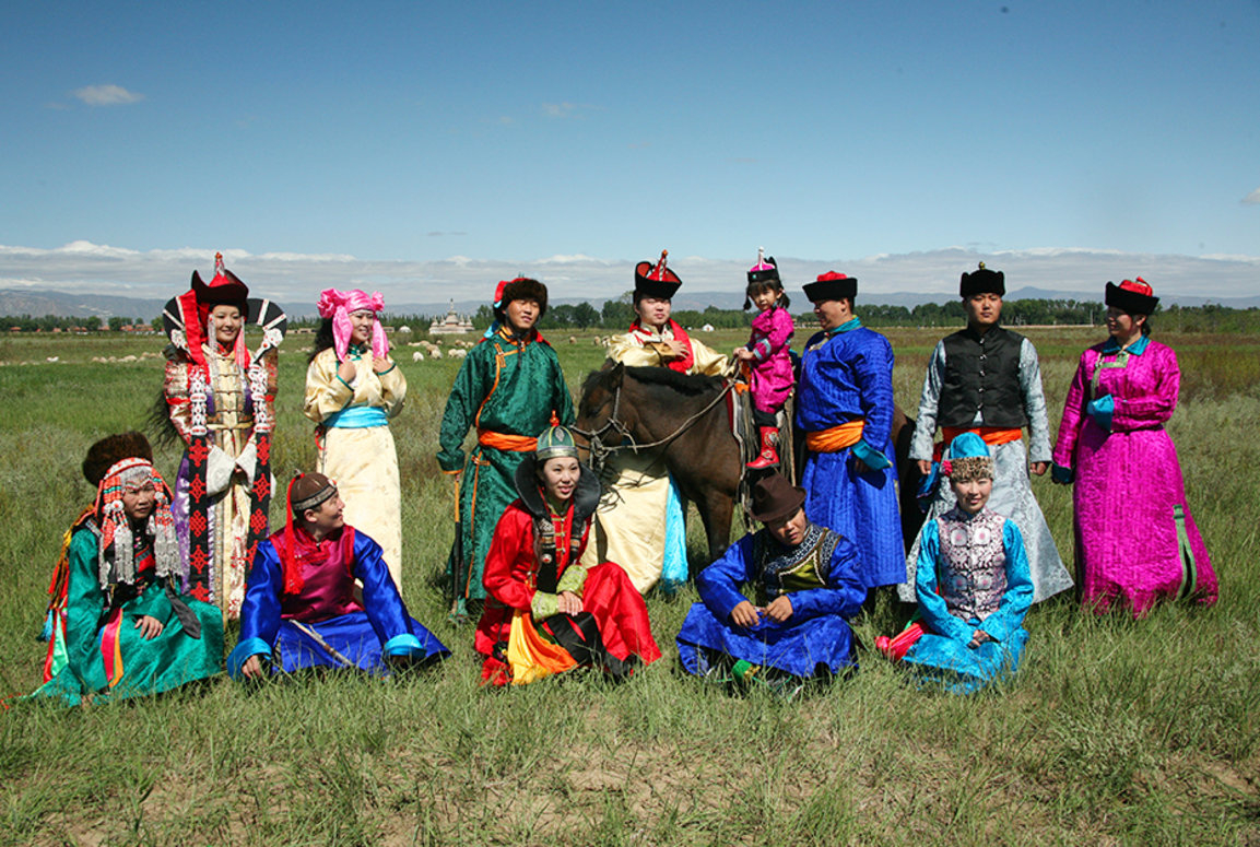
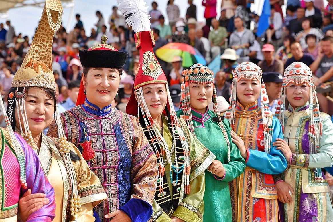
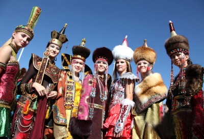


蒙古族(西里尔字母:Монгол үндэстэн),是主要分布于东亚地区的一个传统游牧民族,是中国的少数民族之一,同时也是蒙古国的主体民族。此外,蒙古族在俄罗斯等亚欧国家也有分布,鄂温克族和土族也有时被认为是蒙古族的分支。
蒙古族始源于古代望建河(今额尔古纳河)东岸一带。13世纪初,以成吉思汗为首的蒙古部统一了蒙古地区诸部,逐渐形成了一个新的民族共同体。
蒙古族人民世居草原,以畜牧为生计。过着“逐水草而居”的游牧生活,尽管这种生存方式在现代社会被弱化,但仍然被视作蒙古族的标志。
蒙古族在科学文化事业上比较发达,而且音乐、舞蹈也在艺术上居于相对显赫的地位。
《蒙古秘史》、《蒙古黄金史》、《蒙古源流》被称为蒙古族的三大历史巨著,其中《蒙古秘史》被联合国教科文组织确定为世界著名文化遗产。英雄史诗《江格尔》是中国的三大史诗之一。
全世界蒙古族人约为1000万人。根据《中国统计年鉴-2021》,其中中国境内蒙古族的人口数为6290204人。

木卡姆(阿拉伯语:مقام;英文maqam)是一种音乐调式,广泛流传于中亚地区,在各地有不同的变化。在中国,木卡姆通常指的是新疆地区的维吾尔木卡姆。维吾尔木卡姆是维吾尔诗歌的音乐表达形式,共有十二套大曲,故又称十二木卡姆。
十二套分别為:拉克Rak、且比亚特Čäbbiyat、斯尕Segah、恰尔尕Čahargah、潘尔尕Pänjigah、乌孜哈勒Özhal、艾且Äjäm、乌夏克Uššaq、巴雅提Bayat、纳瓦Nava、木夏吾莱克Mušavräk、依拉克Iraq。
Maqam, arabisch مقام, DMG maqām ‚Standort‘, wörtl. „Ort, auf dem etwas errichtet ist“,[1] Plural Maqamen, Maqame, arabischer Plural Maqamat (مقامات, DMG maqāmāt), davon abgeleitet türkisch makam, Plural makamlar, ist die in der arabischen und türkischen, aber auch in der persischen Kunstmusik[2] benutzte Bezeichnung für den Modus eines Musikstückes.
マカーム(maqām, مقام。複数形はマカーマート maqāmāt)はアラビア語で「留まるところ」を意味し、「場所」「壇」「地位」などの意味で使われる普通名詞だが、中近東の音楽では特に音楽理論用語として使われ、「旋法の体系、システム」を意味する語である。
Arabic maqam (Arabic: مقام, romanized: maqām, literally "rank"; pl. مقامات maqāmāt) is the system of melodic modes used in traditional Arabic music, which is mainly melodic. The word maqam in Arabic means place, location or position. The Arabic maqam is a melody type. It is "a technique of improvisation" that defines the pitches, patterns, and development of a piece of music and which is "unique to Arabian art music".[1] There are seventy two heptatonic tone rows or scales of maqamat.[1] These are constructed from major, neutral, and minor seconds.[1] Each maqam is built on a scale, and carries a tradition that defines its habitual phrases, important notes, melodic development and modulation. Both compositions and improvisations in traditional Arabic music are based on the maqam system. Maqamat can be realized with either vocal or instrumental music, and do not include a rhythmic component.
An essential factor in performance is that each maqam describes the "tonal-spatial factor" or set of musical notes and the relationships between them, including traditional patterns and development of melody, while the "rhythmic-temporal component" is "subjected to no definite organization".[2] A maqam does not have an "established, regularly recurring bar scheme nor an unchanging meter. A certain rhythm does sometimes identify the style of a performer, but this is dependent upon their performance technique and is never characteristic of the maqam as such."[2] The compositional or rather precompositional aspect of the maqam is the tonal-spatial organization including the number of tone levels and the improvisational aspect is the construction of the rhythmic-temporal scheme.[2]
Le maqâm (arabe : مقام) — en turc makam, en azéri mougham, en ouzbek maqôm, en ouïghour mouqâm — est à la fois un système musical général et ses applications particulières.
Le mot maqâm signifiait le lieu où se jouait la musique ; par la suite, il désigna la modalité au Machrek. Maqâm signifie littéralement « station », d'une échelle mélodique en l'occurrence. Il a aussi le sens de « rang élevé » et désigne un modèle transcendant1.
Avant l'adoption du terme maqâm, on utilisait dans les régions arabophones diverses appellations : saout (صوت) qui veut dire voix ou son, naghma (نغمة) qui veut dire mélodie ou tab'e (طبع) qui veut dire "nature" dans le sens de caractère. Comme pour les râgas dans la musique indienne, les maqâmât sont associés aux 4 éléments, au jour et à la nuit et avaient chacun un caractère.
Il s'agit d'une organisation des échelles mélodiques2. À la différence du système des « gammes » (majeures, mineures...) telles qu'on les conçoit et les utilise en Occident, le maqâm est plus qu'un système d'intervalles ; il organise les intervalles entre chaque note ainsi que les cheminements à l'intérieur de cette « échelle » modale, et ce sur plusieurs octaves, généralement deux. Sur ce point, le maqâm se rapproche beaucoup du système des râgas dans la musique classique indienne.
S'il est virtuellement possible d'imaginer une infinité de déclinaisons sur ce principe, notamment en combinant les maqâmât entre eux pour créer des « sous-maqâmât », quelques dizaines seulement sont couramment utilisées et ont acquis une véritable légitimité. Il s'agit là du deuxième sens du maqâm, qui correspond à la définition d'intervalles et de parcours mélodiques singuliers, obéissant à des règles mathématiques et esthétiques. Nous pouvons alors désigner chaque système d'intervalles et de parcours par un nom qui lui est propre et s'y réfère : Hijaz, Husseinî, Bayati...
De nombreux maqâms possèdent des intervalles avoisinant le 3/4 de ton, à la différence des échelles occidentales « tempérées » (où les divisions sont également espacées sur la base de 12 intervalles par octave). Concrètement, cela reviendrait à définir un intervalle supplémentaire entre le si et le do par exemple, en plaçant une nouvelle note : le si ouj. Nous pourrions alors jouer cet intervalle (et cette note) et obtenir une « couleur » particulière correspondant à l'une de grandes « familles » de maqâm.
Il maqam arabo (in arabo: مقام, maqām, letteralmente "luogo"; plurale مقامات tradotto: maqāmāt) è il sistema di modalità melodiche utilizzato nella musica araba tradizionale, che è principalmente melodica. La parola maqam in arabo significa luogo, collocazione o posizione. Il maqam arabo è un tipo di melodia. È "una tecnica di improvvisazione" che definisce i toni, i modelli e lo sviluppo di un brano musicale e che è "unico per la musica araba".[1] Ci sono settantadue righe di toni eptatonici o scale di maqamat.[1] Questi sono costruiti da secondi maggiori, neutri e minori. Ogni maqam è costruito su una scala e porta una tradizione che definisce le sue frasi abituali, le note importanti, lo sviluppo melodico e la modulazione. Sia le composizioni che le improvvisazioni nella musica araba tradizionale si basano sul sistema maqam. I maqamat possono essere realizzati con musica vocale o strumentale e non prevede una componente ritmica.
Un fattore essenziale nell'esecuzione è che ogni maqam descrive il "fattore tonale-spaziale" o insieme di note musicali e le relazioni tra di esse, compresi i modelli tradizionali e lo sviluppo della melodia, mentre la "componente ritmico-temporale" non è soggetta a nessuna organizzazione definita".[2] Un maqam non ha "uno schema di battute stabilito e periodicamente ricorrente né un metro immutabile. Un certo ritmo a volte identifica lo stile di un artista, ma questo dipende dalla sua tecnica di esecuzione e non è mai una caratteristica del maqam in quanto tale".[2] L'aspetto compositivo o piuttosto precomposizionale del maqam è l'organizzazione tonale-spaziale che comprende il numero di livelli di tono e l'aspetto improvvisativo è la costruzione dello schema ritmico-temporale.[2]
El maqam arábico (en árabe: maqām, مقام; -- pl. maqāmāt مقامات o maqams; en español: rango) es el sistema de modos melódicos usado en la música árabe tradicional.
El maqam arábico es un tipo de melodía y una herramienta de improvisación que define alturas, patrones y desarrollo de una pieza de música, los cuales serán únicos a la "música culta" árabe.
Мака́м (араб. مقام, транслит. maqām, букв. стоянка, место стоянки, мн. ч. араб. مقامات транслит. maqāmāt; тюрк. makam, мн. ч. makamlar) — в арабской и турецкой традиционной (профессиональной) музыке многозначный термин, обозначающий (1) ладовый звукоряд, (2) модально-монодический лад в совокупности всех его категорий и функций, (3) целостную текстомузыкальную композицию, включающую не только конкретные приёмы техники композиции (центонизацию, орнаментальное варьирование, импровизацию, ритмическое варьирование и т. д.), но также коннотации музыкального жанра.

 北京市-京
北京市-京
 白俄罗斯
白俄罗斯

 柏林州
柏林州

 布兰登堡州
布兰登堡州

 不来梅州
不来梅州
 中国
中国
 联邦德国
联邦德国
 法国
法国
 甘肃省-陇
甘肃省-陇

 汉堡州
汉堡州
 河北省-冀
河北省-冀
 黑龙江省-黑
 河南省-豫
河南省-豫
 湖北省-鄂
湖北省-鄂
 湖南省-湘
湖南省-湘
 伊朗
伊朗
 意大利
意大利
 吉林省-吉
吉林省-吉
 哈萨克斯坦
哈萨克斯坦
 辽宁省-辽
辽宁省-辽
 内蒙古自治区-内蒙古
 荷兰
荷兰

 下萨克森州
下萨克森州
 宁夏回族自治区-宁

 北莱茵-威斯特法伦州
 波兰
波兰
 葡萄牙
葡萄牙
 俄罗斯
俄罗斯

 萨克森州
萨克森州

 石勒苏益格-荷尔斯泰因州
 陕西省-陕
陕西省-陕
 山东省-鲁
山东省-鲁
 陕西省-陕
陕西省-陕
 四川省-蜀
四川省-蜀
 西班牙
西班牙
 土耳其
土耳其
 土库曼斯坦
土库曼斯坦
 乌兹别克斯坦
 英国
英国
 新疆维吾尔自治区-新
 浙江省-浙
浙江省-浙
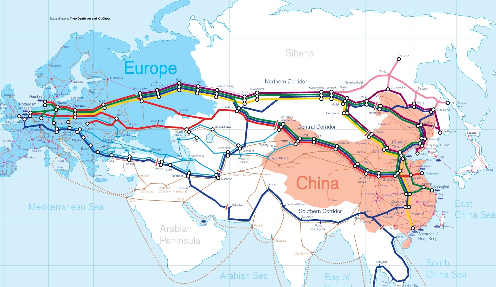
Die Neue eurasische Kontinentalbrücke (chinesisch 新亚欧大陆桥, Pinyin Xīn Yà-Ōu Dàlù Qiáo, englisch New Eurasian Continental Bridge), die auch Zweite eurasische Kontinentalbrücke (第二亚欧大陆桥, Dì'èr Yà-Ōu Dàlù Qiáo, englisch Second Eurasian Continental Bridge) genannt wird, ist eine 10.870 Kilometer[1] lange Eisenbahnverbindung, die Rotterdam in Europa mit der ostchinesischen Hafenstadt Lianyungang in der Provinz Jiangsu verbindet.
Sie besteht seit 1990 und führt durch die Dsungarische Pforte (Grenzbahnhof Alashankou). Die Lan-Xin-Bahn (chinesisch 兰新铁路, Pinyin Lán-Xīn Tiělù), also die Strecke von Lanzhou nach Ürümqi (in Xinjiang), ist ein Teil von ihr.
Es gibt eine nördliche, mittlere und südliche Route.[2] Die mittlere Strecke verläuft durch Kasachstan über Dostyk, Aqtogai, Astana, Samara, Smolensk, Brest, Warschau, Berlin zum Hafen von Rotterdam.[3] Vom slowakischen Košice soll auch eine Abzweigung in den Großraum Wien führen, siehe Breitspurstrecke Košice–Wien.
The New Eurasian Land Bridge, also called the Second or New Eurasian Continental Bridge, is the southern branch of the Eurasian Land Bridge rail links running through China. The Eurasian Land Bridge is the overland rail link between Asia and Europe.
Due to a break-of-gauge between standard gauge used in China and the Russian gauge used in the former Soviet Union countries, containers must be physically transferred from Chinese to Kazakh railway cars at Dostyk on the Chinese-Kazakh border and again at the Belarus-Poland border where the standard gauge used in western Europe begins. This is done with truck-mounted cranes.[1] Chinese media often states that the New Eurasian Land/Continental Bridge extends from Lianyungang to Rotterdam, a distance of 11,870 kilometres (7,380 mi). The exact route used to connect the two cities is not always specified in Chinese media reports, but appears to usually refer to the route which passes through Kazakhstan.
All rail freight from China across the Eurasian Land Bridge must pass north of the Caspian Sea through Russia at some point. A proposed alternative would pass through Turkey and Bulgaria,[2] but any route south of the Caspian Sea must pass through Iran.[1]
Kazakhstan's President Nursultan Nazarbayev urged Eurasian and Chinese leaders at the 18th Shanghai Cooperation Organisation to construct the Eurasian high-speed railway (EHSRW) following a Beijing-Astana-Moscow-Berlin.[3]
The Eurasian Land Bridge (Russian: Евразийский сухопутный мост, Yevraziyskiy sukhoputniy most), sometimes called the New Silk Road (Новый шёлковый путь, Noviy shyolkoviy put'), or Belt and Road Initiative is the rail transport route for moving freight and passengers overland between Pacific seaports in the Russian Far East and China and seaports in Europe. The route, a transcontinental railroad and rail land bridge, currently comprises the Trans-Siberian Railway, which runs through Russia and is sometimes called the Northern East-West Corridor, and the New Eurasian Land Bridge or Second Eurasian Continental Bridge, running through China and Kazakhstan. As of November 2007, about 1% of the $600 billion in goods shipped from Asia to Europe each year were delivered by inland transport routes.[1]
Completed in 1916, the Trans-Siberian connects Moscow with Russian Pacific seaports such as Vladivostok. From the 1960s until the early 1990s the railway served as the primary land bridge between Asia and Europe, until several factors caused the use of the railway for transcontinental freight to dwindle. One factor is that the railways of the former Soviet Union use a wider rail gauge than most of the rest of Europe as well as China. Recently, however, the Trans-Siberian has regained ground as a viable land route between the two continents.[why?]
China's rail system had long linked to the Trans-Siberian via northeastern China and Mongolia. In 1990 China added a link between its rail system and the Trans-Siberian via Kazakhstan. China calls its uninterrupted rail link between the port city of Lianyungang and Kazakhstan the New Eurasian Land Bridge or Second Eurasian Continental Bridge. In addition to Kazakhstan, the railways connect with other countries in Central Asia and the Middle East, including Iran. With the October 2013 completion of the rail link across the Bosphorus under the Marmaray project the New Eurasian Land Bridge now theoretically connects to Europe via Central and South Asia.
Proposed expansion of the Eurasian Land Bridge includes construction of a railway across Kazakhstan that is the same gauge as Chinese railways, rail links to India, Burma, Thailand, Malaysia and elsewhere in Southeast Asia, construction of a rail tunnel and highway bridge across the Bering Strait to connect the Trans-Siberian to the North American rail system, and construction of a rail tunnel between South Korea and Japan. The United Nations has proposed further expansion of the Eurasian Land Bridge, including the Trans-Asian Railway project.
El Nuevo Puente de Tierra de Eurasia es también llamado el Segundo o Nuevo Puente Continental de Eurasia. Es la rama meridional de las conexiones ferroviarias del Puente de Tierra de Eurasia (también conocido como "Nueva Ruta de la Seda") que se extienden a través de la República Popular China, atravesando Kazajistán, Rusia y Bielorrusia. El Puente de Tierra de Eurasia es el enlace ferroviario terrestre entre Asia Oriental y Europa.
La Nueva Ruta de la Seda (en ruso, Новый шёлковый путь, Noviy shyolkoviy put), o Puente Terrestre Euroasiático, es la ruta de transporte ferroviario para el movimiento de tren de mercancías y tren de pasajeros por tierra entre los puertos del Pacífico, en el Lejano Oriente ruso y chino y los puertos marítimos en Europa.
La ruta, un ferrocarril transcontinental y puente terrestre, actualmente comprende el ferrocarril Transiberiano, que se extiende a través de Rusia, y el nuevo puente de tierra de Eurasia o segundo puente continental de Eurasia, que discurre a través de China y Kazajistán, también se van a construir carreteras entre las ciudades de la ruta. A partir de noviembre de 2007, aproximadamente el 1% de los 600 millones de dólares en bienes enviados desde Asia a Europa cada año se entregaron por vías de transporte terrestre.1
Terminado en 1916, el tren Transiberiano conecta Moscú con el lejano puerto de Vladivostok en el océano Pacífico, el más largo del mundo en el Lejano Oriente e importante puerto del Pacífico. Desde la década de 1960 hasta principios de 1990 el ferrocarril sirvió como el principal puente terrestre entre Asia y Europa, hasta que varios factores hicieron que el uso de la vía férrea transcontinental para el transporte de carga disminuyese.
Un factor es que los ferrocarriles de la Unión Soviética utilizan un ancho de vía más ancho en los rieles que la mayor parte del resto de Europa y China, y el transporte en barcos de carga por el canal de Suez en Egipto, construido por Inglaterra. El sistema ferroviario de China se une al Transiberiano en el noreste de China y Mongolia. En 1990 China añadió un enlace entre su sistema ferroviario y el Transiberiano a través de Kazajistán. China denomina a su enlace ferroviario ininterrumpido entre la ciudad portuaria de Lianyungang y Kazajistán como el «Puente terrestre de Nueva Eurasia» o «Segundo puente continental Euroasiático». Además de Kazajistán, los ferrocarriles conectan con otros países de Asia Central y Oriente Medio, incluyendo a Irán. Con la finalización en octubre de 2013 de la línea ferroviaria a través del Bósforo en el marco del proyecto Marmaray el puente de tierra de Nueva Eurasia conecta ahora teóricamente a Europa a través de Asia Central y del Sur.
La propuesta de ampliación del Puente Terrestre Euroasiático incluye la construcción de un ferrocarril a través de Kazajistán con el mismo ancho de vía que los ferrocarriles chinos, enlaces ferroviarios a la India, Birmania, Tailandia, Malasia y otros países del sudeste asiático, la construcción de un túnel ferroviario y un puente de carretera a través del estrecho de Bering para conectar el Transiberiano al sistema ferroviario de América del Norte, y la construcción de un túnel ferroviario entre Corea del Sur y Japón. Las Naciones Unidas ha propuesto una mayor expansión del Puente Terrestre Euroasiático, incluyendo el proyecto del ferrocarril transasiático.
Новый шёлковый путь (Евразийский сухопутный мост — концепция новой паневразийской (в перспективе — межконтинентальной) транспортной системы, продвигаемой Китаем, в сотрудничестве с Казахстаном, Россией и другими странами, для перемещения грузов и пассажиров по суше из Китая в страны Европы. Транспортный маршрут включает трансконтинентальную железную дорогу — Транссибирскую магистраль, которая проходит через Россию и второй Евразийский континентальный мост[en], проходящий через Казахстан[1]. Поезда по этому самому длинному в мире грузовому железнодорожному маршруту из Китая в Германию будут идти 15 дней, что в 2 раза быстрее, чем по морскому маршруту через Суэцкий канал[2].
Идея Нового шёлкового пути основывается на историческом примере древнего Великого шёлкового пути, действовавшего со II в. до н. э. и бывшего одним из важнейших торговых маршрутов в древности и в средние века. Современный НШП является важнейшей частью стратегии развития Китая в современном мире — Новый шёлковый путь не только должен выстроить самые удобные и быстрые транзитные маршруты через центр Евразии, но и усилить экономическое развитие внутренних регионов Китая и соседних стран, а также создать новые рынки для китайских товаров (по состоянию на ноябрь 2007 года, около 1 % от товаров на 600 млрд долл. из Азии в Европу ежегодно доставлялись наземным транспортом[3]).
Китай продвигает проект «Нового шёлкового пути» не просто как возрождение древнего Шёлкового пути, транспортного маршрута между Востоком и Западом, но как масштабное преобразование всей торгово-экономической модели Евразии, и в первую очередь — Центральной и Средней Азии. Китайцы называют эту концепцию — «один пояс — один путь». Она включает в себя множество инфраструктурных проектов, которые должны в итоге опоясать всю планету. Проект всемирной системы транспортных коридоров соединяет Австралию и Индонезию, всю Центральную и Восточную Азию, Ближний Восток, Европу, Африку и через Латинскую Америку выходит к США. Среди проектов в рамках НШП планируются железные дороги и шоссе, морские и воздушные пути, трубопроводы и линии электропередач, и вся сопутствующая инфраструктура. По самым скромным оценкам, НШП втянет в свою орбиту 4,4 миллиарда человек — более половины населения Земли[4].
Предполагаемое расширение Евразийского сухопутного моста включает в себя строительство железнодорожных путей от трансконтинентальных линий в Иран, Индию, Мьянму, Таиланд, Пакистан, Непал, Афганистан и Малайзию, в другие регионы Юго-Восточной Азии и Закавказья (Азербайджан, Грузия). Маршрут включает тоннель Мармарай под проливом Босфор, паромные переправы через Каспийское море (Азербайджан-Иран-Туркменистан-Казахстан) и коридор Север-Юг.Организация Объединенных Наций предложила дальнейшее расширение Евразийского сухопутного моста, в том числе проекта Трансазиатской железной дороги (фактически существует уже в 2 вариантах).
Для развития инфраструктурных проектов в странах вдоль Нового шёлкового пути и Морского Шёлкового пути и с целью содействия сбыту китайской продукции в декабре 2014 года был создан инвестиционный Фонд Шёлкового пути[5].
8 мая 2015 года было подписано совместное заявление Президента РФ В. Путина и Председателя КНР Си Цзиньпина о сотрудничестве России и Китая, в рамках ЕАЭС и трансевразийского торгово-инфраструктурного проекта экономического пояса «Шёлковый путь». 13 июня 2015 года был запущен самый длинный в мире грузовой железнодорожный маршрут Харбин — Гамбург (Германия), через территорию России.
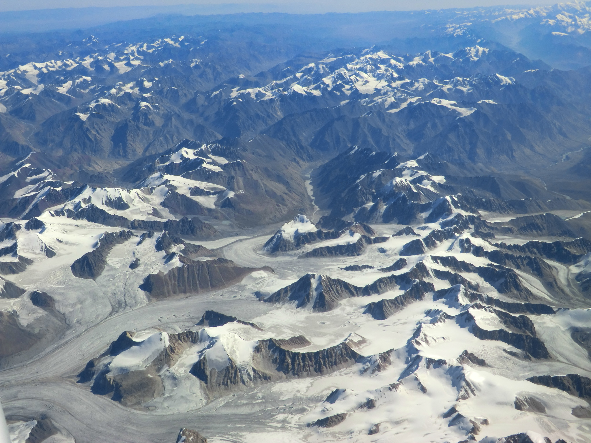
Der äußerste Norden des Faltengebirges jenseits des Transalaigebirges gehört zu Kirgisistan (Gebiet Osch), der Osten jenseits der Sarikolkette zu China (autonomes Gebiet Xinjiang), der Süden zu Afghanistan (Provinz Badachschan), der Rest zu Tadschikistan. Innerhalb Tadschikistans gehört der Pamir hauptsächlich zur autonomen Provinz Berg-Badachschan. Daneben haben nördlich der Darwaskette die der Republik unterstellten Bezirke Anteil am Gebirge, ferner in den westlichsten Ausläufern die Provinz Chatlon.
Der Pamir verbindet einige der großen Gebirgszüge Asiens: Zum Tianshan und dem Alaigebirge im Norden ist er durch das Alai-Tal mit den Flussläufen von Kysylsuu und Surchob abgegrenzt, zum Kunlun Shan im Südosten durch die Flusstäler von Taxkorgan und Yarkant. Im Süden und Südwesten bilden die Läufe von Wachandarja und Pandsch die Abgrenzung zum Hindukusch und indirekt auch zum Karakorum. Im Osten des Pamir schließt das Tarimbecken an, das im Süden durch das Hochland von Tibet begrenzt wird.
Die mittlere Höhe des Pamirs liegt bei etwa 3600 bis 4400 m, was meist über der hier bei 3700 m liegenden Baumgrenze liegt. Der größte See im Pamir ist der Karakul in Tadschikistan. Der längste Gletscher ist der 70 km lange Fedtschenko-Gletscher. Es gibt häufig Erdbeben, durch eines entstand 1911 der Saressee.
Orografisch gehört der größte Teil des Pamir zum Einzugsgebiet des Amudarja und wird somit zum Aralsee entwässert. Tatsächlich umfassen die Läufe der Amudarja-Quellflüsse Kysylsuu, Surchob, Wachsch und Pandsch den Pamir im Norden, Süden und Westen. Entsprechend münden auch weitere große Flüsse des Pamir in diese, darunter der namensgleiche Pamir, der Gunt und der Bartang in den Pandsch, der Obichingou in den Wachsch und der Muksu in den Surchob. Im Osten wird der Pamir zum Tarimbecken entwässert, wobei neben dem Taxkorgan auch der Gez zu erwähnen ist. Im Nordosten wiederum bildet der ebenfalls Kysylsuu genannte Quellfluss des Kaxgar, der wie sein westlicher Namensvetter ebenfalls im Alai-Tal verläuft und von diesem durch den 3536 m hohen Taunmurun-Pass getrennt ist, eine weitere Einfassung des Gebirges.
Das Klima ist rau und trocken. Die Bewohner sind meist Viehzüchter und halten Yaks und Fettschwanzschafe. Das Gebirge ist durch den Pamir Highway erschlossen.
パミール高原(パミールこうげん、英語: Pamir Mountains)あるいはパミル高原は、タジキスタン、アフガニスタン、中国などにまたがる平均標高5000メートルに達する高原で、中国では葱嶺(そうれい)と呼ばれていた[1]。「パミール」は、タジク語で「世界の屋根」を意味するといわれる[2]。
東パミール、中部パミール、西パミールに分かれ、東パミールの中国領に最高峰コングール山(7719メートル)やムスタグアタ山(7546メートル)があり、西パミールの最高峰はタジキスタン領のイスモイル・ソモニ峰(7495メートル)である[1]。
この高原から東北に向かって天山山脈、南方に向かって崑崙山脈、カラコルム山脈、ヒマラヤ山脈、西南に向かってヒンドゥークシュ山脈が伸びており、「世界の屋根」と呼ぶにふさわしい地形である[3]。タクラマカン砂漠を通るシルクロードは、この高原を越えて東西を結んでいた。
タジキスタン東部のゴルノ・バダフシャン自治州にはイラン系のパミール人やテュルク系のキルギス人が暮らしている。
The Pamir Mountains are a mountain range between Central Asia, South Asia, and East Asia, at the junction of the Himalayas with the Tian Shan, Karakoram, Kunlun, Hindu Kush, and Hindu Raj ranges. They are among the world's highest mountains.
The Pamir Mountains lie mostly in the Gorno-Badakhshan Province of Tajikistan.[1] To the north, they join the Tian Shan mountains along the Alay Valley of Kyrgyzstan. To the south, they border the Hindu Kush mountains along Afghanistan's Wakhan Corridor. To the east, they extend to the range that includes China's Kongur Tagh, in the "Eastern Pamirs",[2] separated by the Yarkand valley from the Kunlun Mountains.
Le Pamir est un massif de haute montagne centré sur l'Est du Tadjikistan avec des prolongements en Afghanistan, en République populaire de Chine et au Kirghizistan. Situé à la jonction entre plusieurs systèmes orographiques d'Asie centrale et du Tibet, il possède trois sommets principaux de plus de 7 000 mètres dont le pic Ismail Samani, généralement considéré comme son point culminant à 7 495 mètres d'altitude, ce qui a valu au massif le qualificatif de « toit du monde ». Son nom s'applique aussi bien à un certain type de vallée glaciaire plus fertile que les montagnes et les plateaux qui les entourent. Ces derniers sont généralement soumis à des conditions climatiques extrêmes, avec des précipitations très faibles et des écarts de températures importants, en particulier dans la moitié orientale désertique du massif. Toutefois, le Pamir est l'une des régions qui abritent le plus de glaciers en dehors des pôles, dont le glacier Fedtchenko avec 77 kilomètres de long. Ceci lui permet d'être parcouru par un grand nombre de rivières appartenant aux bassins de l'Amou-Daria à l'ouest et du Tarim à l'est, et de contenir des centaines de lacs. Alors que la pauvreté de la flore caractérise l'écorégion unique des toundra et désert d'altitude du Pamir, la faune est très diversifiée. Ainsi, l'Argali de Marco Polo est une espèce tout à la fois endémique et menacée de disparition.
Le massif est fréquenté depuis plusieurs millénaires. Il s'est trouvé sur des itinéraires secondaires de la route de la soie dès l'Antiquité. Toutefois, seuls les Tadjiks dès le IIe siècle puis les Kirghizes à partir du XVIe siècle y demeurent. Marco Polo est le premier Européen à faire mention, au XIIIe siècle, de sa traversée du Pamir. Rares sont ceux qui suivent ses pas jusqu'au milieu du XIXe siècle, lorsqu'il est exploré et placé au cœur d'un conflit géopolitique, le « Grand Jeu », entre l'Empire russe au nord et l'Inde britannique au sud. Le massif retombe dans l'oubli occidental au XXe siècle. Au XXIe siècle, il est peuplé par différentes populations qui se sont adaptées à la montagne : des Tadjiks, à l'ouest et au sud, et des Kirghizes, au nord et à l'est. Ces derniers mènent une vie semi-nomade, emmenant paître leurs animaux dans les quelques pamirs fertiles. Ils ont perpétué une culture riche de nombreuses traditions particulières.
Le Pamir reste une des régions les plus isolées au monde. Les infrastructures sont peu développées et la population continue à dépendre de l'aide extérieure. Le tourisme, essentiellement axé sur l'alpinisme, le trekking et l'écotourisme peine à se développer, malgré la présence de nombreuses aires protégées, notamment le parc national du Pamir qui est le plus grand d'Asie centrale.
Il Pamir è un elevato massiccio montuoso situato prevalentemente nella parte orientale del Tagikistan, ma anche nelle aree limitrofe di Afghanistan, Cina e Kirghizistan. Situato nel punto dove convergono vari sistemi orografici dell'Asia centrale e del Tibet, presenta tre cime principali che superano i 7000 metri, tra le quali il picco Ismail Samani (7495 metri), generalmente considerato la sua cima più alta, che hanno valso al massiccio l'appellativo di «tetto del mondo». Con il nome comune pamir (plurale pamiri) si indicano anche un certo tipo di valli glaciali più fertili delle montagne e degli altopiani circostanti, che sono generalmente caratterizzati da condizioni climatiche estreme, con precipitazioni molto scarse ed escursioni termiche considerevoli, in particolare nella parte orientale desertica del massiccio. Tuttavia, il Pamir è una delle regioni che ospitano più ghiacciai al di fuori dei poli, come il ghiacciaio Fedčenko, lungo 77 chilometri; di conseguenza esso è attraversato da un gran numero di fiumi appartenenti ai bacini dell'Amu Darya ad ovest e del Tarim ad est e ospita centinaia di laghi. Nonostante l'estrema scarsità della flora che caratterizza l'ecoregione della tundra e deserto d'altitudine del Pamir, la fauna è molto diversificata: tra le specie maggiormente degne di nota figura l'argali di Marco Polo, una specie endemica e in pericolo di estinzione.
L'uomo frequenta la regione del Pamir da vari millenni: essa si trova infatti lungo uno degli itinerari secondari della via della seta, che nell'Antichità attraversava l'Asia centrale, ma solamente i Tagiki a partire dal II secolo e i Kirghisi a partire dal XVI vi si sono insediati permanentemente. Marco Polo, nel XIII secolo, fu il primo europeo a raccontare la sua traversata del Pamir. Tuttavia, furono ben pochi quelli che seguirono le sue orme, almeno fino alla metà del XIX secolo, quando la zona venne esplorata e si trovò al centro di un conflitto geopolitico, il cosiddetto «Grande Gioco», tra l'Impero russo a nord e l'India britannica a sud. Finita quest'epoca, il Pamir ripiombò nuovamente nell'oblio durante il XX secolo. Attualmente, è abitato da varie popolazioni adattatesi a vivere in montagna: i Tagiki, ad ovest e a sud, e i Kirghisi, a nord e ad est. Questi ultimi, che si spostano con le loro greggi nei pochi pamiri fertili, conducono uno stile di vita semi-nomade e sono i custodi di una cultura ricca di tradizioni popolari.
Il Pamir rimane tuttora una delle regioni più isolate del mondo. Le infrastrutture sono poco sviluppate e la popolazione continua a dipendere dagli aiuti esterni. Anche il turismo, basato essenzialmente su alpinismo, trekking ed ecoturismo, stenta a svilupparsi, malgrado la presenza di numerose aree protette, tra le quali il parco nazionale del Pamir, il più grande dell'Asia centrale.
El Pamir, nudo del Pamir o Pamires —o incluso poco acertadamente cordillera del PamirNota 1—, es un macizo de alta montaña del Asia central centrado en la región del Alto Badajshán, en el este de Tayikistán, que se extiende por Afganistán, la República Popular de China, Kirguistán y Pakistán. Nudo orográficoIv. 1 situado en la unión de varios sistemas —los montes Tian, al norte, la cordillera del Kunlun, al este, los Karakoram, al sur, y el Hindu Kush, al suroeste1—, tiene tres cumbres principales de más de 7000 m —como el pico Ismail Samani, generalmente considerado como su punto culminante a 7495 m—, que lo convierten en el quinto sistema montañoso más alto del mundo, y una de los únicos seis que superan los sietemil metros. Junto al Tíbet, era conocido en tiempos victorianos como el «techo del mundo» (Roof of the World), en una traducción aproximada del término persa.2 Es conocido también por su nombre en chino, Congling.3
Pamir se aplica también a cierto tipo de valle glaciar más fértil que las montañas y las mesetas que lo rodean. Estos últimos están generalmente sujetos a condiciones climáticas extremas, con escasas precipitaciones y diferencias significativas de temperatura, en particular en la mitad oriental desértica del macizo. Sin embargo, el Pamir es una de las regiones que tiene más glaciares fuera de los polos, incluido el glaciar Fedchenko de 77 km de longitud. Esto le permite ser recorrido por una gran cantidad de ríos que pertenecen a las cuencas del Amu Daria, en el oeste, y a la del Tarim, en el este, y tener cientos de lagos. Si bien la pobreza de la flora caracteriza a la ecorregión única de tundra y desierto de altitud del Pamir, la fauna es muy diversa, sobresaliendo el argali de Marco Polo, una especie endémica y amenazada de extinción.
El macizo ha sido frecuentado por el hombre desde hace varios milenios. El lapis lazuli encontrado en las tumbas egipcias se considera que provenía de la región del Pamir.4 Hacia 138 a. C. Zhang Qian ascendió por el valle de Ferganá, al noroeste de los Pamires.4 Claudio Ptolomeo ya describió vagamente la ruta comercial en esta área.4 Aproximadamente en el año 600, peregrinos budistas viajaban a ambos lados de los Pamires para alcanzar la India desde China.4 En el año 747, un ejército de la dinastía Tang estuvo en el río Wakhan.4 Se encuentran en el macizo itinerarios secundarios de la ruta de la seda desde la Antigüedad. Sin embargo, solo los tayikos desde el siglo II y los kirguises a partir del siglo XVI se establecieron allí. Marco Polo fue el primer europeo en mencionar, en el siglo XIII, su travesía del Pamir. Pocos siguieron sus pasos hasta mediados del siglo XIX —se recuerda en 1602, a Bento de Goes, que viajaba desde Kabul a Yarkanda y dejó un informe sobre la cordillera del Pamir4— cuando fue explorado; en 1838 el teniente John Wood llegó a la cabecera del río Pamir.4 Desde aproximadamente 1868 hasta 1880, un número de hindúes del servicio secreto británico exploraron el área Panj.4 y la región fue colocada en el corazón de un conflicto geopolítico, El Gran Juego, entre el Imperio ruso, en el norte, y la India británica, en el sur. El macizo cayó en el olvido occidental en el siglo XX. En el siglo XXI, está poblado por diferentes poblaciones que se han adaptado a las montañas: tayikos, al oeste y sur, y kirguises, al norte y al este. Estos últimos llevan una vida seminómada, llevando a sus animales a pastar en los pocos pamires fértiles. Han perpetuado una cultura rica en muchas tradiciones particulares.
El Pamir sigue siendo una de las regiones más aisladas del mundo. Las infraestructuras están muy poco desarrolladas y la población sigue dependiendo de la ayuda externa. El turismo, enfocado principalmente en el montañismo, el trekking y el ecoturismo, está desarrollándose, a pesar de la existencia de muchas áreas protegidas, incluido el parque nacional Pamir, que es el más grande de Asia Central.
Cubiertos por la nieve la mayor parte del año, y batidos por abundantes granizadas, los Pamires gozan de un clima alpino de inviernos largos y muy fríos y veranos cortos y frescos. La precipitación anual, con un promedio de 130 mm, mantiene praderas y muy pocos árboles.
Пами́р (кит. упр. 帕米尔, пиньинь Pàmǐ'ěr, перс. پامیر, тадж. Помир) — горная система на юге Центральной Азии и на севере горной гряды Гималаи, преимущественно на территории Таджикистана (Горно-Бадахшанская автономная область)[к. 1][1], Китая, Афганистана и Пакистана. Памир находится на соединении отрогов других мощных горных систем Центральной Азии — Гиндукуша, Каракорума, Куньлуня и Тянь-Шаня[к. 2].
В XVIII—XX веках Памир и окружающие его области стали ареной геополитического соперничества Британской и Российской империй, что получило в истории британской геополитики название «Большая Игра»[к. 3].
В настоящее время Памир является узлом неразрешённых противоречий между рядом государств, что ведёт к геополитическому напряжению в регионе[2].
 蒙古
蒙古
 音乐排行榜
音乐排行榜

 音乐
音乐
 文化遗产
文化遗产
 天文
天文


 动物世界
动物世界
 地理
地理
 运输和交通
运输和交通

 企业
企业

 阿富汗
阿富汗
