
漢德百科全書 | 汉德百科全书
 Silk road
Brazil
FIFA Fussball-Weltmeisterschaft 2014
Olympic Summer Games
Rio de Janeiro
Silk road
Silk road
Brazil
FIFA Fussball-Weltmeisterschaft 2014
Olympic Summer Games
Rio de Janeiro
Silk road
 Important port

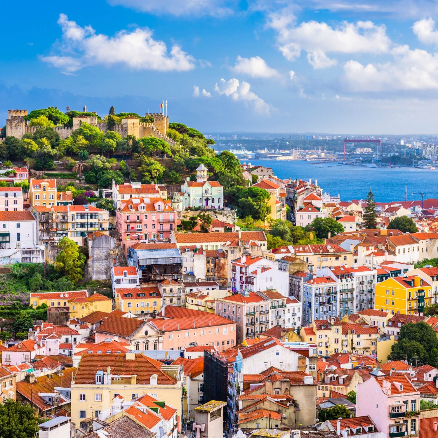
Rio de Janeiro [ˈʁi.u d(ʒi) ʒɐˈne(j)ɾu, ˈʁi.u d(ʑi) ʑɐˈne(j)ɾu] ist nach São Paulo die zweitgrößte Stadt Brasiliens und Hauptstadt des gleichnamigen Bundesstaates. Sie liegt an der Guanabara-Bucht im Südosten des Landes. Der Name (deutsch Fluss des Januar) beruht auf einem Irrtum des Seefahrers Gaspar de Lemos, der die Bucht am 1. Januar 1502 entdeckte und für die Mündung eines großen Flusses hielt. Im administrativen Stadtgebiet leben rund 6,7 Millionen Menschen (Schätzung 2018).[1] Die Metropolregion Rio de Janeiro hat rund 13,3 Millionen Einwohner (Schätzung 2018).[2] Somit gehört Rio de Janeiro zu den Megastädten dieser Erde.
Von 1815 bis 1821 war Rio de Janeiro Hauptstadt des Königreiches von Portugal und Brasilien und nach der Unabhängigkeit Brasiliens 1822 bis 1960 die Hauptstadt des Landes. Danach trat sie diese Funktion an Brasília ab, bleibt aber nach São Paulo bedeutendstes Handels- und Finanzzentrum des Landes. Von 1808 bis 1822 war die Stadt auch Sitz des portugiesischen Hofes, der wegen eines Angriffs durch Napoleon Bonaparte nach Brasilien flüchten musste. Die Bewohner der Stadt nennt man Cariocas, nach einem Wort aus der zum Tupí-Guaraní gehörenden Sprache der Tupinambá, welches „Hütte des weißen Mannes“ bedeutet.
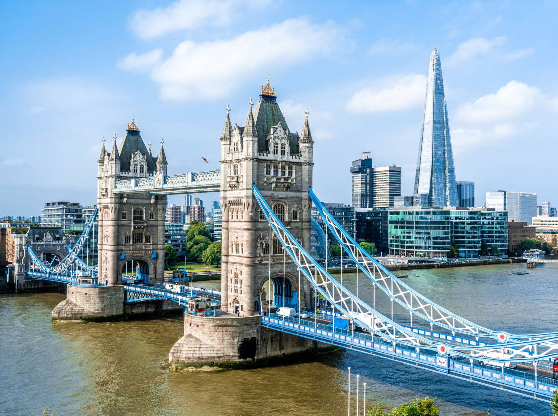
Wahrzeichen von Rio de Janeiro sind der Zuckerhut, die 38 Meter hohe Christusfigur auf dem Gipfel des Corcovados und der Strand des Stadtteils Copacabana, der als einer der berühmtesten der Welt gilt. Die Stadt ist auch bekannt wegen des jährlich stattfindenden Karnevals von Rio. Die bunte Parade der Sambaschulen gehört zu den größten Paraden der Welt.
里约热内卢位于巴西国土的东南部,坐落在美丽的瓜纳巴拉海湾,依山傍水,风景优美,是巴西和世界著名的旅游观光胜地。面积4.36万平方公里。人口 1,413.3万(1990),城市人口占90%以上。1889年设州,1975年瓜纳巴拉州并入,首府由尼泰罗伊迁至里约热内卢市。沿海低地气候湿热, 内地高原气候温和。重要河流有帕拉伊巴河等。工农业和服务业均甚发达,服务业占就业人口约37%和收入的一半。工业以钢铁、纺织、食品、印刷、石油化工为 主。有石油、铝土、铁、煤、大理石等矿产。渔业和盐业兴盛。农业主产甘蔗、柑橘、香蕉、蔬菜、棉花、水果、稻,饲养牲畜。水、陆、空交通发达。风景优美, 多游览胜地。
(Quelle: http://www.uutuu.com)
里约热内卢(葡萄牙语:Rio de Janeiro,葡萄牙语发音:[ˈʁi.u dʒi ʒɐˈnejɾu],意即“一月的河”),有时仅简称为里约(Rio),是位于巴西东南部的城市,为里约热内卢州首府,同时是巴西第二大城,仅次于圣保罗。面积1,256平方公里,人口6,094,183人(2005年)。其自1822年巴西建国以来一直为首都,至1960年4月21日迁都巴西利亚为止,更曾经成为前宗主国葡萄牙在本土被拿破仑入侵时(1808年–1821年)的流亡首都[3]。风景优美,每年吸引大量游客到此观光,市内的里约热内卢港是世界三大天然良港之一,而里约热内卢基督像也是世界新七大奇迹之一。其亦为第31届夏季奥运的主办地,是第一座举办夏季奥运的南美洲城市。
リオ・デ・ジャネイロ(葡: Rio de Janeiro, ブラジルポルトガル語発音: ヒウ・ヂ・ジャネイル)は、ブラジル南東部に位置するリオデジャネイロ州の州都。世界有数のメガシティであり、国内最大の観光都市である。港湾都市としても知られる。
人口は600万人を超え、サンパウロに次いでブラジル第2位にランクされる。経済規模(域内総生産)でもサンパウロに次いで第2位にあり、アメリカのシンクタンクが公表したビジネス・人材・文化・政治などを対象とした総合的な世界都市ランキングにおいて、世界第56位、国内ではサンパウロに次ぐ第2位の都市と評価された[1]。都市周辺の美しい文化的景観は「リオデジャネイロ:山と海との間のカリオカの景観群」として、2012年に世界遺産リストに登録された。2016年の第31回夏季オリンピックの開催都市である。
カーニバルで有名。コパカバーナ、イパネマ(英語版)などの世界的に有名な海岸を有し世界3大美港の一つに数えられる美しい都市である。都市のGDPは2010億ドルであり世界第30位、南米ではサンパウロ、ブエノスアイレスに次ぎ第3位である[2]。
1960年にブラジリアに遷都するまではブラジルの首都であった。また、1808年にナポレオンに本国領土を奪われたポルトガル王室が遷都してからブラジルが独立するまではポルトガルの首都であった。また、中南米有数の貿易港でもあるためにブラジルの経済的な中心地でもあった。近年は経済の中心地はサンパウロに移り、その地位が低下しているものの、依然として中南米有数の経済都市である。また、ブラジルのみならず世界でも有数の観光地としても、ショーロ、ボサノヴァを生んだ音楽の都としても名高い。
Rio de Janeiro (/ˈriːoʊ di ʒəˈnɛəroʊ, - deɪ -, - də -/; Portuguese: [ˈʁi.u d(ʒi) ʒɐˈne(j)ɾu];[3] River of January), or simply Rio,[4] is anchor to the Rio de Janeiro metropolitan area and the second-most populous municipality in Brazil and the sixth-most populous in the Americas. Rio de Janeiro is the capital of the state of Rio de Janeiro, Brazil's third-most populous state. Part of the city has been designated as a World Heritage Site, named "Rio de Janeiro: Carioca Landscapes between the Mountain and the Sea", by UNESCO on 1 July 2012 as a Cultural Landscape.[5]
Founded in 1565 by the Portuguese, the city was initially the seat of the Captaincy of Rio de Janeiro, a domain of the Portuguese Empire. Later, in 1763, it became the capital of the State of Brazil, a state of the Portuguese Empire. In 1808, when the Portuguese Royal Court transferred itself from Portugal to Brazil, Rio de Janeiro became the chosen seat of the court of Queen Maria I of Portugal, who subsequently, in 1815, under the leadership of her son, the Prince Regent, and future King João VI of Portugal, raised Brazil to the dignity of a kingdom, within the United Kingdom of Portugal, Brazil, and Algarves. Rio stayed the capital of the pluricontinental Lusitanian monarchy until 1822, when the War of Brazilian Independence began. This is one of the few instances in history that the capital of a colonising country officially shifted to a city in one of its colonies. Rio de Janeiro subsequently served as the capital of the independent monarchy, the Empire of Brazil, until 1889, and then the capital of a republican Brazil until 1960 when the capital was transferred to Brasília.
Rio de Janeiro has the second largest municipal GDP in the country,[6] and 30th largest in the world in 2008,[7] estimated at about R$343 billion (IBGE, 2008) (nearly US$201 billion). It is headquarters to Brazilian oil, mining, and telecommunications companies, including two of the country's major corporations – Petrobras and Vale – and Latin America's largest telemedia conglomerate, Grupo Globo. The home of many universities and institutes, it is the second-largest center of research and development in Brazil, accounting for 17% of national scientific output according to 2005 data.[8] Despite the high perception of crime, the city has a lower incidence of crime than Northeast Brazil, but it is far more criminalized than the south region of Brazil, which is considered the safest in the country.[9]
Rio de Janeiro is one of the most visited cities in the Southern Hemisphere and is known for its natural settings, Carnival, samba, bossa nova, and balneario beaches[10] such as Barra da Tijuca, Copacabana, Ipanema, and Leblon. In addition to the beaches, some of the most famous landmarks include the giant statue of Christ the Redeemer atop Corcovado mountain, named one of the New Seven Wonders of the World; Sugarloaf Mountain with its cable car; the Sambódromo (Sambadrome), a permanent grandstand-lined parade avenue which is used during Carnival; and Maracanã Stadium, one of the world's largest football stadiums. Rio de Janeiro was the host of the 2016 Summer Olympics and the 2016 Summer Paralympics, making the city the first South American and Portuguese-speaking city to ever host the events, and the third time the Olympics were held in a Southern Hemisphere city.[11] The Maracanã Stadium held the finals of the 1950 and 2014 FIFA World Cups, the 2013 FIFA Confederations Cup, and the XV Pan American Games.
Rio de Janeiro [ˈʁi.u d(ʒi) ʒɐˈnejɾu]2, souvent désignée simplement sous le nom de Rio, est la deuxième plus grande ville du Brésil après São Paulo. Située au sud-est du pays, elle est la capitale de l'État de Rio de Janeiro. Avec ses 6,1 millions d'habitants intra-muros (communément appelés Cariocas, la variante Carioques existant aussi en français) et 12,62 millions dans l'aire urbaine, Rio de Janeiro est l'une des métropoles les plus importantes du continent américain.
Elle est mondialement connue pour son carnaval, ses plages (Copacabana, Leblon et Ipanema) ainsi que sa statue du Christ Rédempteur au sommet du Corcovado. Elle fut capitale du Royaume-Uni de Portugal, du Brésil et des Algarves, à la suite de la fuite de la cour portugaise lors de l'invasion des troupes napoléoniennes (1808-1821), puis de l'Empire du Brésil (1822-1889), de la República Velha (1889-1930), de l’Estado Novo (1937-1945) et du début de la Deuxième République jusqu'en 1960.
La ville a accueilli les Journées mondiales de la jeunesse 2013, la finale de la Coupe du monde de football de 2014 et enfin, en 2016, les Jeux olympiques d'été.
Rio de Janeiro (pron. [ˈrio deʒaˈnɛiro];[2] letteralmente "Fiume di gennaio" in portoghese) è una città del Brasile, capitale dell'omonimo stato confederato. Rio è la seconda città del Brasile dopo San Paolo e fu la capitale dello Stato federale dal 1763 fino al 1960, dopo Salvador da Bahia e prima di Brasilia.
La città è famosa per le sue attrattive turistiche tra cui spiccano le spiagge di Copacabana e Ipanema, la gigantesca statua liberty del Cristo Redentore, situata sul monte del Corcovado, il monte del Pão de Açúcar (Pan di Zucchero), con la sua funivia, e il suo annuale carnevale, il più celebre al mondo.
La città è al centro della scena internazionale, avendo ospitato alcuni dei più grandi eventi mondiali degli ultimi anni: nel 2007 i XV Giochi Panamericani, nel 2013 la XXVIII Giornata Mondiale della Gioventù e nel 2016 i giochi della XXXI Olimpiade. È stata inoltre una delle città in cui si è disputato il Campionato del mondo di calcio 2014.
Rio de Janeiro contiene anche la più grande foresta all'interno di un'area urbana, la foresta di Tijuca.
L'attuale sindaco è Marcelo Crivella, in carica dal 1º gennaio 2017, del PRB.
Río de Janeiro1 (en portugués, Rio de Janeiro, AFI: [ˈʁi.u dʒi ʒaˈnejɾu]), fundada como São Sebastião do Rio de Janeiro,3 es una ciudad, municipio brasileño y capital del estado homónimo, ubicada en el sureste del país. Es la segunda ciudad más poblada del país después de São Paulo.4
Fue la capital del Reino de Portugal entre 1808 y 1822 y la capital del Imperio del Brasil desde 1822, cuando la nación declaró su independencia del país luso y conservó ese rango hasta la inauguración de Brasilia, en 1960.
Es uno de los principales centros económicos, de recursos culturales y financieros del Brasil. Es conocida internacionalmente por sus iconos culturales y paisajes, como el Pan de Azúcar, la estatua del Cristo Redentor (una de las siete maravillas del mundo moderno), las playas de Copacabana e Ipanema, el Estadio de Maracaná, el Parque Nacional de Tijuca (el mayor bosque urbano del mundo), la Quinta da Boa Vista, la isla de Paquetá, las Fiestas de Fin de Año en Copacabana y la celebración del Carnaval
Representa el segundo mayor PIB en el país y 30.º mayor del mundo, además de ser sede de dos de las más importantes empresas brasileñas —Petrobras y Vale do Rio Doce, ahora privatizada— y las principales empresas de petróleo y la telefonía, así como del mayor conglomerado de compañías de medios y comunicaciones de Latinoamérica.[cita requerida] Es el segundo centro más grande de investigación y desarrollo en Brasil, alcanzando el 17% de la producción científica nacional (según datos de 2005).
Río de Janeiro es considerada una ciudad global Beta- por el inventario de 2008 de la Universidad de Loughborough (GaWC).5
Es conocida mundialmente como la "Ciudad Maravillosa" (Cidade Maravilhosa), en portugués, albergó la Copa Mundial de Fútbol de 1950, la Copa Confederaciones 2013, la Jornada Mundial de la Juventud 2013, la Copa Mundial de Fútbol de 2014 y los Juegos Olímpicos de Río de Janeiro 2016.
Ри́о-де-Жане́йро, или, сокращённо, Рио (порт. Rio de Janeiro, буквально — январская река) — город в Бразилии, административный центр одноимённого штата.
Население — 6,4 млн человек (2014), это второй по величине город страны и четвёртый Южной Америки. Образует агломерацию с населением 12 млн человек (2011 год)[6]. Крупный финансовый центр и морской порт на континенте, научный центр.
Расположен на берегу залива Гуанабара Атлантического океана, на узкой равнине, зажатой с двух сторон горами и морем. Климат тропический[1][2]. Местность открыта португальским мореплавателем Гашпаром ди Лемушем, принявшим залив Гуанабара за реку, которую назвали Январской рекой[уточнить]. В 1531 году основан португальский форт Сан-Себастьян де-Рио-де-Жанейро. С 1763 — столица вице-королевства Бразилии, с 1822 года — столица независимой Бразильской империи, в 1889—1960 годы — столица республики Соединённых штатов Бразилии.
Исторический центр с постройками XVI—XIX веков. Побережье вместе с пляжем Копакабана, горой Сахарная Голова и статуей Христа внесено в список Всемирного наследия ЮНЕСКО[7].
Eurovision Song Contest,ESC
Hansestadt
 International cities
 *European Capital of Culture
Latvia
Silk road
*European Capital of Culture
Latvia
Silk road
 World Heritage
Important port
World Heritage
Important port

Riga (lettisch Rīga) ist die Hauptstadt Lettlands und mit rund 700.000 Einwohnern größte Stadt des Baltikums. Mit etwa einer Million Einwohnern in der Agglomeration ist Riga zudem der größte Ballungsraum in den drei baltischen Staaten. Riga ist politisches, wirtschaftliches und kulturelles Zentrum des Landes. Die alte Hansestadt ist berühmt für ihre Jugendstilbauten und ihre großzügige Anlage sowie für die gut erhaltene Innenstadt, darunter besonders die Altstadt. 2016 wurde Riga der Ehrentitel „Reformationsstadt Europas“ durch die Gemeinschaft Evangelischer Kirchen in Europa verliehen.[1]
里加(拉脱维亚语:Rīga, 英语:Riga)是拉脱维亚的首都,北欧地区波罗的海国家中最大、最繁忙的城市,位于波罗的海岸边,道加瓦河口。
里加是波罗的海国家主要的政治、经济、文化、教育和工商业中心。里加是历史上汉萨同盟主要商业城市,其历史中心被列入世界遗产名录,联合国教科文组织特别认为里加丰富的新艺术运动建筑是世界上独一无二的[2]。
欧盟欧洲电子通讯监管机构总部以及北大西洋公约组织的战略通讯中心设在里加。里加是欧洲城市组织及欧洲首都联盟组织成员。2014年欧洲文化之都,世界合唱比赛,2006年北大西洋公约组织峰会,2003年欧洲歌唱大赛,2006年世界男子冰球锦标赛,2003年世界女子冰壶球锦标赛等活动的举办地。
リガ、またはリーガ[1](ラトビア語: Rīga 発音 [ˈriːɡa] (![]() 音声ファイル)、ロシア語: Рига、エストニア語: Riia、リトアニア語: Ryga、英語、ドイツ語: Riga)は、ラトビア共和国の首都で、同国最大の人口を擁する都市。人口は69万9,203人(2012年時点)。「バルト海の真珠」と讃えられる美しい港町で、その旧市街はユネスコの世界遺産(文化遺産)に登録されている。 世界遺産に登録されている旧市街「リガ歴史地区」は約300棟のアールヌーボー調の建築物の宝庫として著名である。新市街は官庁やオフィスが集まる。郊外には、ラトビア民俗博物館があり、野外博物館も兼ねている。また、保養地として知られる海岸、ユールマーラも西方にある。人口約70万人のリガ市はラトビア国内はもとより、バルト三国最大の都市でもある。市内で最も高い建築物はリガラジオ&テレビタワーである。
音声ファイル)、ロシア語: Рига、エストニア語: Riia、リトアニア語: Ryga、英語、ドイツ語: Riga)は、ラトビア共和国の首都で、同国最大の人口を擁する都市。人口は69万9,203人(2012年時点)。「バルト海の真珠」と讃えられる美しい港町で、その旧市街はユネスコの世界遺産(文化遺産)に登録されている。 世界遺産に登録されている旧市街「リガ歴史地区」は約300棟のアールヌーボー調の建築物の宝庫として著名である。新市街は官庁やオフィスが集まる。郊外には、ラトビア民俗博物館があり、野外博物館も兼ねている。また、保養地として知られる海岸、ユールマーラも西方にある。人口約70万人のリガ市はラトビア国内はもとより、バルト三国最大の都市でもある。市内で最も高い建築物はリガラジオ&テレビタワーである。
Riga (/ˈriːɡə/; Latvian: Rīga [ˈriːɡa] ( listen), Livonian: Rīgõ) is the capital and largest city of Latvia. With 641,481 inhabitants (2016),[4] it is also the largest city in the three Baltic states, home to one third of Latvia's population and one tenth of the three Baltic states' combined population.[9] The city lies on the Gulf of Riga, at the mouth of the Daugava. Riga's territory covers 307.17 km2 (118.60 sq mi) and lies 1–10 m (3 ft 3 in–32 ft 10 in) above sea level,[10] on a flat and sandy plain.[10]
Riga was founded in 1201 and is a former Hanseatic League member. Riga's historical centre is a UNESCO World Heritage Site, noted for its Art Nouveau/Jugendstil architecture and 19th century wooden architecture.[11] Riga was the European Capital of Culture during 2014, along with Umeå in Sweden. Riga hosted the 2006 NATO Summit, the Eurovision Song Contest 2003, the 2006 IIHF Men's World Ice Hockey Championships and the 2013 World Women's Curling Championship. It is home to the European Union's office of European Regulators for Electronic Communications (BEREC).
In 2016, Riga received over 1.4 million visitors.[12] It is served by Riga International Airport, the largest and busiest airport in the Baltic states. Riga is a member of Eurocities,[13] the Union of the Baltic Cities (UBC)[14] and Union of Capitals of the European Union (UCEU).[15]
Riga (prononcé [ʁi.ga] ; en letton Rīga [riː.ga]) est la capitale de la Lettonie. Construite sur la mer Baltique au fond du golfe de Riga, dans lequel se jette la Daugava, c'est un centre industriel, commercial, culturel et financier majeur de la région de Vidzeme.
Riga (in lettone Rīga) è la capitale della Lettonia. Situata sul Mar Baltico alla foce del fiume Daugava, con 699.203 abitanti al censimento del 2011, è la città più grande delle Repubbliche Baltiche ed è uno dei principali centri culturali, politici ed economici della regione. Antico centro della lega anseatica, la città è gemellata con Firenze e Brema. Nel 2001 ha ospitato il Mese culturale europeo assieme a Basilea, mentre nel 2014 è stata Capitale europea della cultura affiancata ad Umeå.
Riga (en letón: Rīga [ˈriːɡa] (?·i)) es la capital y la mayor ciudad de Letonia. Es la ciudad más grande de los Estados bálticos y el hogar de más de un tercio de la población de Letonia.1 Es el mayor centro cultural, educativo, político, financiero, comercial e industrial de la región del mar Báltico.
La ciudad se encuentra en el golfo de Riga, en la desembocadura del río Daugava. Tiene un área de 307,17 km² y se encuentra en una llanura arenosa entre 1 y 10 metros sobre el nivel del mar.2
Riga fue fundada en 1201 y es un antiguo miembro de la Liga Hanseática. El centro histórico de Riga, declarado Patrimonio de la Humanidad por la Unesco, destaca por su arquitectura art nouveau y sus construcciones de madera del siglo XIX.3 La ciudad fue designada Capital Europea de la Cultura en 2014, junto a Umeå en Suecia.
La ciudad está comunicada por vía aérea gracias al Aeropuerto Internacional de Riga, el aeropuerto más grande de los países bálticos.
Riga es miembro de Eurocities,4 la unión de las ciudades bálticas (UBC)5 y la Unión de Capitales de la Unión Europea (UCEU).6
Ри́га (латыш. ![]() Rīga [ˈriːɡa], лив. Rīgõ) — столица Латвии и самый крупный город в Прибалтике с численностью населения 637 971 человека (2018 год)[2]. Политический, экономический и культурный центр страны. Находится на обоих берегах реки Даугавы, недалеко от её впадения в Рижский залив.
Rīga [ˈriːɡa], лив. Rīgõ) — столица Латвии и самый крупный город в Прибалтике с численностью населения 637 971 человека (2018 год)[2]. Политический, экономический и культурный центр страны. Находится на обоих берегах реки Даугавы, недалеко от её впадения в Рижский залив.
Рига долгое время была ганзейским городом, здесь соседствуют здания различных стилей от средневековой архитектуры старого города до модерна и современной архитектуры. Она была одним из крупнейших портов и одним из важнейших промышленных, коммерческих и культурных центров в Российской Империи. Исторический центр города внесен в список Всемирного наследия ЮНЕСКО[4]. В 2014 году Рига была выбрана одной из культурных столиц Европы[5].
Eurovision Song Contest,ESC
 History
International cities
*European Capital of Culture
Portugal
Silk road
History
International cities
*European Capital of Culture
Portugal
Silk road
 Sport
The Ocean Race
Umwelthauptstadt Europas
Important port
Sport
The Ocean Race
Umwelthauptstadt Europas
Important port
Lissabon (portugiesisch Lisboa [liʒˈβoɐ]) ist die Hauptstadt und die größte Stadt Portugals sowie des gleichnamigen Regierungsbezirks und liegt an einer Bucht der Flussmündung des Tejo im äußersten Südwesten Europas an der Atlantikküste der Iberischen Halbinsel.
Der Handelshafen an der Tejo-Bucht wurde vor der römischen Herrschaft Alis Ubbo genannt. Lissabon, eine Gründung der Phönizier, erhielt zu Zeiten Julius Caesars unter dem Namen Colonia Felicitas Iulia römisches Stadtrecht. 711 fiel der Ort wie der größte Teil der Iberischen Halbinsel an die Mauren; im Kontext des Zweiten Kreuzzugs wurde Lissabon 1147 portugiesisch und damit wieder unter christliche Herrschaft gestellt. Nach der Verlegung des Königssitzes von Coimbra wurde die Stadt im Jahr 1256 unter König Afonso III. zur Hauptstadt des Königreichs Portugal. Um 1500 erlebte Lissabon einen brillanten Aufstieg zu einer der glanzvollsten Handels- und Hafenstädte der damaligen Zeit.
Ein gewaltiges Erdbeben besiegelte im Jahr 1755 den wirtschaftlichen Niedergang der Stadt, der bereits Jahrzehnte zuvor schleichend eingesetzt hatte, und sorgte in ganz Europa für Aufsehen. Im 19. Jahrhundert erlebte Lissabon einen Wiederaufstieg.
In den letzten Jahren ist die Stadt allerdings massiv geschrumpft (von über 800.000 Einwohnern um 1980 auf etwa 500.000[3] um 2017); viele Menschen sind in das Umland gezogen. Lissabon hat mit erheblichen strukturellen Problemen zu kämpfen, unter denen vor allem die marode Bausubstanz vieler Gebäude und der enorme Straßenverkehr herausragen.
Als noch immer größte Stadt Portugals mit dem wichtigsten Hafen, dem Regierungssitz, den obersten Staats- und Regierungsbehörden, mehreren Universitäten und der Akademie der Wissenschaften ist Lissabon heute das politische, wirtschaftliche und kulturelle Zentrum des Landes.
Lissabon ist Sitz einiger Agenturen der Europäischen Union, darunter der Europäischen Beobachtungsstelle für Drogen und Drogensucht und der Europäischen Agentur für die Sicherheit des Seeverkehrs. Auch die Gemeinschaft der Portugiesischsprachigen Länder (CPLP) hat ihren Hauptsitz in Lissabon.
里斯本(葡萄牙语:Lisboa),亦称为葡京,是葡萄牙共和国的首都和最大都市。其位置位于葡萄牙中南部大西洋沿岸,城北为辛特拉山,城南为特茹河出海口,与伦敦、巴黎、罗马等同为西欧历史最悠久的城市。市区面积84.6平方公里、人口547,631人(2011年)。包含卫星城的都会区人口超过300万,相当于葡萄牙人口的27%左右。公元前205年起为罗马人统治,当时的统治者凯撒把这个地区升格为市,并命名为拉丁语:Felicitas Julia(意为“祝贺凯撒”)。1256年起正式成为葡萄牙王国的首都,从此发展成为欧洲和地中海一带重要的港口与贸易城市。地理大发现时代很多航海家都是由里斯本出发到世界不同的地方探险的,此后成为葡萄牙殖民帝国富甲一方的政治与商业中心,现今与波尔图同为葡萄牙两大代表性城市。
リスボン(ポルトガル語: Lisboa IPA: [ɫiʒˈboɐ] (![]() 音声ファイル)[1]、[liʒˈβoɐ] リジュボア[2]、英語: Lisbon IPA: [ˈlɪzbən])は、ポルトガルの首都で同国最大の都市である。市域人口は547,631人を擁し[3]、市域面積は84.8 km2 (33 sq mi)に過ぎないが、そのぶん高い人口密度を保持している。リスボンの都市的地域は行政区としての市域を越えて広がっており、人口は300万人を超え[4]、面積は958 km2 (370 sq mi)[4]を占めており、欧州連合域内では11番目に大きな都市圏 (en) を形成している。約3,035,000人[5][6] の人々が、リスボン都市圏に暮らし、ポルトガルの全人口の約27%を占めている。リスボンはヨーロッパの大都市では最も西にある都市であると同時に、ヨーロッパの中で最も西側に位置する政府首都でもある。ヨーロッパ諸国の首都のなかで唯一の大西洋岸にあるリスボンは、イベリア半島の西側、テージョ川の河畔に位置している。
音声ファイル)[1]、[liʒˈβoɐ] リジュボア[2]、英語: Lisbon IPA: [ˈlɪzbən])は、ポルトガルの首都で同国最大の都市である。市域人口は547,631人を擁し[3]、市域面積は84.8 km2 (33 sq mi)に過ぎないが、そのぶん高い人口密度を保持している。リスボンの都市的地域は行政区としての市域を越えて広がっており、人口は300万人を超え[4]、面積は958 km2 (370 sq mi)[4]を占めており、欧州連合域内では11番目に大きな都市圏 (en) を形成している。約3,035,000人[5][6] の人々が、リスボン都市圏に暮らし、ポルトガルの全人口の約27%を占めている。リスボンはヨーロッパの大都市では最も西にある都市であると同時に、ヨーロッパの中で最も西側に位置する政府首都でもある。ヨーロッパ諸国の首都のなかで唯一の大西洋岸にあるリスボンは、イベリア半島の西側、テージョ川の河畔に位置している。
リスボンは金融や商業、出版、娯楽、芸術、貿易、教育、観光と言った様々な分野で重要な都市であることから、世界都市と見なされている。[7][8] ポルテラ空港は2012年に1,530万人の旅客を扱い、高速道路Auto-estradaや高速列車アルファ・ペンドゥラールによりポルトガルの他の主要都市と結ばれている。[9]南ヨーロッパではイスタンブール、ローマ、バルセロナ、マドリード、アテネ、ミラノに次いで7番目に多くの観光客が訪れる都市で、2009年には1,740,000人の観光客が訪れた。[10]リスボンの総所得は世界の都市で32番目に高い位置を占めている。[11] ポルトガルの多国籍企業の本社はほとんどがリスボン地域に置いており、世界では9番目に多くの国際会議が開かれる都市でもある。[12]
また、ポルトガルの政治の中心でポルトガル政府の首府やポルトガルの大統領官邸が置かれている他、リスボン地域やリスボン県の中心でもある。
世界的にも古い歴史がある都市の一つで、西ヨーロッパでは最古の都市であり現代のヨーロッパの他の首都であるロンドンやパリ、ローマなどよりも数百年遡る。ガイウス・ユリウス・カエサルはフェリキタス・ユリアFelicitas Juliaと呼ばれるムニキピウムを創建し、オリピソOlissipoの名に加えた。5世紀から一連のゲルマン人部族により支配され、8世紀にはムーア人により攻略された。1147年、ポルトガル王国の建国者アフォンソ1世下のレコンキスタでのリスボン攻防戦で、ポルトガルはムーア人からリスボンを奪回する。以来、リスボンはポルトガルの主要な政治、経済、文化の中心となっている。ほとんどの首都と異なり、リスボンのポルトガルの首都としての地位は法令や書面の形式では公式に認められたり確認されていない。首都としての地位は憲法制定会議を通じて事実上の首都としてポルトガルの憲法に定められている。
リスボンには欧州薬物・薬物依存監視センター(EMCDDA)と欧州海上保安機関(EMSA)の2つの欧州連合の専門機関が置かれている。「ルゾフォニアの世界の首都」と呼ばれポルトガル語諸国共同体の本部がペナフィエル伯宮殿に置かれている。ベレンの塔とジェロニモス修道院の2つはUNESCOの世界遺産に登録されている。さらに1994年、リスボンは欧州文化首都になり、1998年にはリスボン国際博覧会が開催された。
Lisbon (/ˈlɪzbən/; Portuguese: Lisboa, IPA: [liʒˈboɐ] (![]() listen))[2] is the capital and the largest city of Portugal, with an estimated population of 505,526[1] within its administrative limits in an area of 100.05 km2.[3] Its urban area extends beyond the city's administrative limits with a population of around 2.8 million people, being the 11th-most populous urban area in the European Union.[4] About 3 million people live in the Lisbon Metropolitan Area (which represents approximately 27% of the country's population).[5] It is mainland Europe's westernmost capital city and the only one along the Atlantic coast. Lisbon lies in the western Iberian Peninsula on the Atlantic Ocean and the River Tagus. The westernmost areas of its metro area form the westernmost point of Continental Europe, which is known as Cabo da Roca, located in the Sintra Mountains
listen))[2] is the capital and the largest city of Portugal, with an estimated population of 505,526[1] within its administrative limits in an area of 100.05 km2.[3] Its urban area extends beyond the city's administrative limits with a population of around 2.8 million people, being the 11th-most populous urban area in the European Union.[4] About 3 million people live in the Lisbon Metropolitan Area (which represents approximately 27% of the country's population).[5] It is mainland Europe's westernmost capital city and the only one along the Atlantic coast. Lisbon lies in the western Iberian Peninsula on the Atlantic Ocean and the River Tagus. The westernmost areas of its metro area form the westernmost point of Continental Europe, which is known as Cabo da Roca, located in the Sintra Mountains
Lisbon is recognised as an alpha-level global city by the Globalization and World Cities (GaWC) Study Group because of its importance in finance, commerce, media, entertainment, arts, international trade, education and tourism.[6] Lisbon is the only Portuguese city besides Porto to be recognised as a global city.[7][8] It is one of the major economic centres on the continent, with a growing financial sector and one of the largest container ports on Europe's Atlantic coast.[9] Additionally, Humberto Delgado Airport served 26.7 million passengers in 2017, being the busiest airport in Portugal, the 3rd busiest in the Iberian Peninsula and the 20th busiest in Europe,[10] and the motorway network and the high-speed rail system of Alfa Pendular links the main cities of Portugal (such as Braga, Porto and Coimbra) to Lisbon.[11] The city is the 9th-most-visited city in Southern Europe, after Rome, Istanbul, Barcelona, Milan, Venice, Madrid, Florence and Athens, with 3,320,300 tourists in 2017.[12] The Lisbon region contributes with a higher GDP PPP per capita than any other region in Portugal. Its GDP amounts to 96.3 billion USD and thus $32,434 per capita.[13][14] The city occupies the 40th place of highest gross earnings in the world.[15] Most of the headquarters of multinationals in the country are located in the Lisbon area.[16] It is also the political centre of the country, as its seat of Government and residence of the Head of State.
Lisbon is one of the oldest cities in the world, and one of the oldest in Western Europe, predating other modern European capitals such as London, Paris and Rome by centuries. Julius Caesar made it a municipium called Felicitas Julia, adding to the name Olissipo. Ruled by a series of Germanic tribes from the 5th century, it was captured by the Moors in the 8th century. In 1147, the Crusaders under Afonso Henriques reconquered the city and since then it has been a major political, economic and cultural centre of Portugal. Unlike most capital cities, Lisbon's status as the capital of Portugal has never been granted or confirmed officially – by statute or in written form. Its position as the capital has formed through constitutional convention, making its position as de facto capital a part of the Constitution of Portugal.
Lisbonne [liz.bɔn]2 (en portugais : Lisboa [liʒˈboɐ]3 Écouter) est la capitale et la plus grande ville du Portugal. Considérée comme une « ville mondiale » selon le classement 2010 du Réseau d’étude sur la mondialisation et les villes mondiales (GaWC)4 comme Taipei, Miami, Varsovie ou Munich, Lisbonne est également le chef-lieu du district de Lisbonne, du Grand Lisbonne et de la zone métropolitaine de Lisbonne. Ses habitants sont habituellement appelés Lisboètes (du portugais lisboeta), mais on rencontre aussi les termes Lisbonnin et Lisbonnais.
D'après le recensement de 2011, la municipalité compterait une population de 545 733 habitants5, répartie sur une surface de 83,7 km2. L'agglomération de Lisbonne (Grand Lisbonne) compte une population légèrement supérieure à 2,042 millions d'habitants (NUTS III), ce qui en fait la 15e agglomération européenne en importance. Son aire urbaine (Région de Lisbonne) compte quant à elle 2 821 876 habitants (NUTS II), représentant 26,7 % de la population portugaise. C'est la ville la plus riche du Portugal, avec un PIB par habitant supérieur au PIB moyen de l'Union européenne.
Située à l'embouchure du Tage, la municipalité est divisée en 24 freguesias (paroisses civiles ou arrondissements). Elle est limitée par les communes de Odivelas et Loures au nord, Oeiras à l'ouest, Amadora au nord-ouest et l'estuaire du Tage (la mer de Paille) au sud-est, au travers duquel, la ville est au contact des municipalités de la rive sud : Almada, Seixal, Barreiro, Moita, Montijo et Alcochete.
Deux agences européennes ont leur siège à Lisbonne : l'Observatoire européen des drogues et des toxicomanies et l'Agence européenne pour la sécurité maritime, toutes les deux avec des projets de nouveaux sièges près du fleuve. L'organisation de la Communauté des pays de langue portugaise a également ses bureaux dans la capitale portugaise.
Lisbona (/liz'bona/; in portoghese: Lisboa, /liʒ'boɐ/) è la capitale e principale città del Portogallo, con una popolazione di circa 506 892 abitanti all'interno dei suoi confini amministrativi, mentre circa 2,8 milioni sono gli abitanti della sua area urbana (undicesima nell'Unione Europea). È la capitale europea più occidentale (isole escluse) e l'unica ad affacciarsi sull'Oceano Atlantico. La città è situata nella parte occidentale della Penisola iberica, presso l'estuario del fiume Tago, ed inoltre la parte più occidentale della sua area urbana è la zona geografica più occidentale dell'intera Europa continentale.
Lisbona è considerata una città globale in virtù della sua discreta importanza in settori come finanza, commercio, editoria, arte, commercio internazionale, istruzione e turismo. È un importante centro economico, con un settore finanziario in crescita ed uno tra i più importanti porti affaccianti sull'Atlantico. L'aeroporto di Lisbona serve circa 20 milioni di passeggeri all'anno e importanti strade e autostrade collegano la capitale alle altre città portoghesi. La città è la settima più visitata nel Sud Europa, dopo Istanbul, Roma, Barcellona, Madrid, Atene e Milano, con 1 740 000 turisti nel 2009. La regione di Lisbona ha un PIL procapite considerevolmente più alto della media nazionale, classificandosi al decimo posto nella UE con 110 miliardi di euro e 39.375€ pro capite, dato del 40% più alto rispetto alla media dell'unione. La maggior parte dei quartier generali delle multinazionali portoghesi è localizzata in città, che è anche il maggior centro politico dello stato, essendo sede del Governo e della Presidenza della Repubblica.
Lisboa (pronunciación en portugués: ![]() [liʒˈβoɐ] (?·i)) es la capital1 y mayor ciudad de Portugal. Situada en la desembocadura del río Tajo (Tejo), es la capital del país, capital del distrito de Lisboa, de la región de Lisboa, del Área Metropolitana de Lisboa, y es también el principal centro de la subregión de la Gran Lisboa. La ciudad tiene una población de 547 773 habitantes y su área metropolitana se sitúa en los 2 810 923 en una superficie de 2921,90 km². Esta área contiene el 20 % de la población del país. Lisboa es la ciudad más rica de Portugal[cita requerida].
[liʒˈβoɐ] (?·i)) es la capital1 y mayor ciudad de Portugal. Situada en la desembocadura del río Tajo (Tejo), es la capital del país, capital del distrito de Lisboa, de la región de Lisboa, del Área Metropolitana de Lisboa, y es también el principal centro de la subregión de la Gran Lisboa. La ciudad tiene una población de 547 773 habitantes y su área metropolitana se sitúa en los 2 810 923 en una superficie de 2921,90 km². Esta área contiene el 20 % de la población del país. Lisboa es la ciudad más rica de Portugal[cita requerida].
El municipio de Lisboa, que coincide con la ciudad propiamente dicha (excluyendo la aglomeración urbana continua, más grande, que la rodea), tiene una extensión de 100,05 km², en los que en 2011 vivían 547 733 habitantes.2 Su densidad demográfica es de 5 474,59 hab/km². El municipio se subdivide en 24 freguesias (parroquias) y limita al norte con los municipios de Odivelas y Loures, al oeste con Oeiras, al noroeste con Amadora y al sureste con el estuario del Tajo. A través del estuario, Lisboa se une a los municipios de la Margen Sur: Almada, Seixal, Barreiro, Moita, Montijo y Alcochete.
Лиссабо́н[4], Лисабо́н[5][6] (порт. Lisboa, МФА (порт.): [liʒˈβoɐ]) — столица, крупнейший город и главный порт Португалии.
Лиссабон является одним из старейших городов мира и старейшим городом Западной Европы, на века превосходя в возрасте такие современные европейские столицы, как Лондон, Париж.
В Лиссабоне средиземноморский климат. В нём самые теплые зимы среди всех европейских метрополий — средние температуры с декабря по февраль составляют 18 °C днем и 11 °C ночью. Типичный летний сезон длится около шести месяцев — с мая по октябрь, хотя и в апреле температура порой достигает 25-32 °C.
England
International cities
*European Capital of Culture
Silk road
United Kingdom
World Heritage
Important port

Liverpool [ˈlɪvəpuːl] ist eine Stadt und Metropolitan Borough im Nordwesten von England im Vereinigten Königreich Großbritannien und Nordirland, an der Mündung des Flusses Mersey. Im Jahr 2014 hatte die Stadt 473.073 Einwohner, im Ballungsraum Liverpool Urban Area lebten 817.000 Einwohner. Liverpool ist der zweitgrößte Exporthafen Großbritanniens.
Der historische Teil der Hafenstadt wurde 2004 zum Weltkulturerbe erklärt. Bekannt ist die Stadt durch die traditionsreichen Fußballvereine FC Everton und FC Liverpool sowie durch ihre pulsierende Musikszene, aus der in den 1960er Jahren unter anderem die Rockband The Beatles hervorging. 2008 war Liverpool (neben Stavanger in Norwegen) Europäische Kulturhauptstadt.
Die Einwohner Liverpools werden offiziell Liverpudlians genannt. Besser bekannt ist die Bezeichnung Scousers, nach dem in Liverpool gesprochenen Dialekt Scouse, dessen Name sich wiederum von der lokalen Eintopfspezialität Scouse herleitet.
利物浦(英语:Liverpool /ˈlɪvərpuːl/),是英格兰西北部著名港口城市,是默西赛德都市郡的5个自治市之一,由利物浦市议会治理。1207年时以自治市镇的身份成立,1880年获得城市地位。2011年人口约为466,415[4],是利物浦都会区的中心[5]。利物浦市区的人口约为2,200,000,英国第四大城市。[6]
利物浦居民称为Liverpudlians,但也称“Scousers”,后裔名称来自当地名吃炖汤“scouse”,同时这一词还指利物浦方言[7]。利物浦居民种族颇为丰富,有全英最古老的黑人社区和全欧最古老的华人社区。
吉尼斯世界纪录将利物浦评为“世界流行乐之都”[8],披头士、比利·弗里、格里和带头人及其他许多乐队都是在此发迹的。两支英超联球会:利物浦和埃弗顿也位于利物浦。2007年时利物浦庆祝其800岁诞辰,次年与斯塔万格一起成为欧洲文化之都[9]。
利物浦的历史建筑保护良好,其中许多都举世闻名。市中心的多个地区在2004年被联合国教科文组织评为世界遗产,并称利物浦海事商城。[10]
リヴァプール(Liverpool)は、イギリス・イングランド北西部マージーサイド州の中心都市である。面積は111.84平方キロメートル、2015年の人口は47万8580人[1]。かつてはイギリスの主要な港湾都市であったが、世界的ロック・バンドであるザ・ビートルズの出身地であることから、いまでは観光都市として知られる。2008年の欧州文化首都の一つ。
Liverpool (/ˈlɪvərpuːl/) is a city in North West England, with an estimated population of 491,500 in 2017.[5] Its metropolitan area is the fifth-largest in the UK, with a population of 2.24 million in 2011.[6] The local authority is Liverpool City Council, the most populous local government district in the metropolitan county of Merseyside and the largest in the Liverpool City Region.
Liverpool is on the eastern side of the Mersey Estuary, and historically lay within the ancient hundred of West Derby in the south west of the county of Lancashire.[7][8] It became a borough in 1207 and a city in 1880. In 1889, it became a county borough independent of Lancashire. Its growth as a major port was paralleled by the expansion of the city throughout the Industrial Revolution. Along with handling general cargo, freight, raw materials such as coal and cotton, the city merchants were involved in the Atlantic slave trade. In the 19th century, it was a major port of departure for Irish and English emigrants to North America. Liverpool was home to both the Cunard and White Star Line, and was the port of registry of the ocean liner RMS Titanic, the RMS Lusitania, RMS Queen Mary and RMS Olympic.
The popularity of the Beatles and other groups from the Merseybeat era contributes to Liverpool's status as a tourist destination. Liverpool is also the home of two Premier League football clubs, Liverpool and Everton, matches between the two being known as the Merseyside derby. The Grand National horse race takes place annually at Aintree Racecourse on the outskirts of the city.
The city celebrated its 800th anniversary in 2007. In 2008, it was nominated as the annual European Capital of Culture together with Stavanger, Norway.[9] Several areas of the city centre were granted World Heritage Site status by UNESCO in 2004. The Liverpool Maritime Mercantile City includes the Pier Head, Albert Dock, and William Brown Street.[10] Liverpool's status as a port city has attracted a diverse population, which, historically, was drawn from a wide range of peoples, cultures, and religions, particularly from Ireland and Wales. The city is also home to the oldest Black African community in the country and the oldest Chinese community in Europe.
Natives and residents of the city of Liverpool are referred to as Liverpudlians, and colloquially as "Scousers", a reference to "scouse", a form of stew. The word "Scouse" has also become synonymous with the Liverpool accent and dialect.
Liverpool est une cité et un district métropolitain du Merseyside dans la région de l'Angleterre du Nord-Ouest sur la rive est et nord de l'estuaire du fleuve Mersey. La ville faisait partie du comté du Lancashire jusqu'en 1974 avant la formation du comté de Merseyside.
La ville est fondée en 1207 et obtient le statut de cité en 1880. Avec une population de 491 500 habitants en 2017, c'est la sixième plus grande ville du Royaume-Uni, et la quatrième d'Angleterre ; l'aire urbaine de Liverpool comprend 864 122 habitants en 2011 (6e région urbaine du Royaume-Uni)1. Ses habitants s'appellent les Liverpuldiens (Liverpudlians en anglais)2.
L'ensablement progressif de l'estuaire de la Dee, sur lequel se tenait le port de Chester depuis l'époque romaine, a permis à Liverpool de devenir un port majeur. Au début du XIXe siècle, alors que l'Empire britannique était en pleine expansion économique, environ 40 % de son commerce passe par Liverpool, ce qui contribue grandement à l'importance de la ville. En 1930, la ville est à son apogée avec une population de plus de 850 000 habitants.
Bombardée durant la Seconde Guerre mondiale, la ville entame au lendemain de la guerre sa reconstruction, mais elle est rapidement touchée par la crise industrielle des années 1970 qui affecte son activité portuaire et dont elle se remet lentement. Liverpool a ainsi perdu de nombreux habitants mais demeure encore une métropole économique de premier rang pour le Nord-Ouest anglais. La ville a entamé un processus de reconversion dans le secteur tertiaire : services à l'industrie, activités commerciales (Liverpool One), et le tourisme (Albert Dock).
Liverpool est associée à la popularité des Beatles, un des plus grands phénomènes de l'industrie discographique mondiale, et développe son activité touristique principalement autour des groupes de musique des années 1960 et des galeries d'art et musées. Sixième ville la plus visitée du Royaume-Uni, Liverpool possède le deuxième plus grand nombre de musées après Londres. En 2004, plusieurs quartiers de la ville obtiennent le statut de Patrimoine mondial et la ville partage le titre de capitale européenne de la culture en 2008 avec Stavanger (Norvège) pour célébrer son 800e anniversaire.
Ville multi-culturelle (elle abrite une des plus anciennes communautés chinoises et africaines d'Europe), elle est aussi un important pôle universitaire, et est également célèbre pour ses deux principaux clubs de football, Everton et Liverpool, qui évoluent tous deux en Premier League.
L'accent propre aux habitants de Liverpool et du Merseyside est le « scouse » (terme anglais désignant également un ragoût à base de pommes de terre, de viande salée et d'oignons). Le mot « Scouser » est utilisé pour désigner les gens possédant cet accent ou, de façon plus générale, toute personne venant de Liverpool.
Liverpool (AFI: [ˈliverpul][2]; in inglese [ˈlɪvəpuːl]) è una città di 578 324 abitanti del Regno Unito e un distretto metropolitano, capoluogo della contea metropolitana inglese del Merseyside. Sorge lungo l'estuario della Mersey e affaccia sul Mare d'Irlanda, non lontano dal confine con il Galles.
Liverpool es una ciudad y municipio metropolitano del condado de Merseyside, en la región Noroeste de Inglaterra, sobre el lado este del estuario del río Mersey en Reino Unido. Limita al norte con el municipio metropolitano de Sefton, al este con el de Knowsley, al sur y oeste con el mencionado río. Fue fundada como villa en 1207 y tuvo ese estatus hasta 1880, cuando recibió el título de ciudad. Según el último censo oficial, que data de 2001, Liverpool tenía una población de 439 473 habitantes;2 esta cifra aumenta ligeramente hasta los 454 654 habitantes según estimaciones para el año 2009.1 La ciudad se encuentra en el centro del Área Metropolitana de Liverpool, cuya población asciende a 816 216 habitantes.
Históricamente perteneciente al condado de Lancashire, la urbanización y expansión de Liverpool se debió en gran parte a su condición de ciudad portuaria importante. En el siglo XVIII, el comercio con las Indias Occidentales, con la Europa continental y el tráfico de esclavos en el Atlántico promovió la expansión económica de la ciudad. A principios del siglo XIX, el 40% del comercio marítimo mundial pasaba por los muelles de Liverpool. Actualmente es el segundo puerto del Reino Unido en volumen de exportaciones tras Londres.
La popularidad de The Beatles (también destacaron otros grupos como por ejemplo The Scaffold3 ) y del equipo de fútbol Liverpool Football Club contribuyen a convertir a Liverpool en un destino turístico; el turismo juega un papel significante en la economía de la ciudad. En 2007 celebró su 800.º aniversario, y al año siguiente fue Capital Europea de la Cultura junto a la ciudad noruega de Stavanger.4
En 2004, varias zonas a lo largo del centro de la ciudad fueron declaradas Patrimonio de la Humanidad por la Unesco. Conocido como la «Ciudad mercantil marítima de Liverpool», el lugar comprende seis localizaciones separadas en la ciudad, incluyendo «Pier Head», «Albert Dock» y la «calle William Brown»; incluye la mayoría de los puntos de interés más famosos de la ciudad.5
Ливерпу́ль, также Ливерпул[2] (англ. Liverpool, МФА: [ˈlɪvəpuːl]) — город в Великобритании в графстве Мерсисайд, порт на северо-западном побережье Англии, в устье реки Мерси.
Население — 441 477 человек (2002 год) — пятый по величине город Великобритании (и третий — в Англии). Население Ливерпульской агломерации превышает 800 000 жителей. На протяжении 2-й половины XX века Ливерпуль имел славу депрессивного города: с 1930-х до начала 2000-х годов его население сократилось почти вдвое[3].
 Vacation and Travel

Während der Tang-Dynastie galt Lianyungang als Ausgangspunkt einer Handelslinie, die China mit anderen Ländern in Südostasien verband.
江蘇省の東北部にあって黄海に面し、北は山東省日照市、西は徐州市、淮安市、南は淮安市、塩城市に隣接。気候は海流の影響で温暖で、年平均気温は14℃、年間降水量は930mm。全体に海沿いの平坦な土地だが、西部には山地があり、その最高点である南雲台山の玉女峰(標高625m)は江蘇省の最高点でもある。 農業も盛んで、水稲や小麦、綿、大豆、落花生などが生産されている。
連雲港市(れんうんこう-し)は中華人民共和国江蘇省に位置する地級市。全国十大港湾の一つである貿易港を有し、中国に14ある沿海の経済技術開発区の一つでもある。連雲港の古い名は海州であり、春秋時代には呉を滅ぼした越王勾践がこの地を首都とし中原の覇者となった。秦朝以降は江蘇地方の重要港湾都市とされ、清末には税関が設置されている。改革開放政策が発表されてからは中国で最初に指定された14箇所の経済技術開発区の一つになった。
行政区画としては1935年(民国24年)に灌雲県連雲港地区に新設された連雲市を前身とする。1948年(民国37年)には東海県海州、新浦地区を統合し新海連特区と改編された。中華人民共和国が成立すると1949年に新海連市と改称し山東省の管轄とした。その後1952年に江蘇省に移管、1961年に連雲港市と改称され現在に至る。
Lianyungang (simplified Chinese: 连云港; traditional Chinese: 連雲港; pinyin: Liányúngǎng) is a prefecture-level city in northeastern Jiangsu province, China. It borders Yancheng to its southeast, Huai'an and Suqian to its south, Xuzhou to its southwest, and the province of Shandong to its north. Its name derives from Lian Island, the largest island in Jiangsu which lies off its coastline, and Yuntai Mountain, the highest peak in Jiangsu, a few miles from the town center, and the fact that it is a port. The name can be literally translated as the Port Connecting the Clouds.
Lianyungang (连云港 ; pinyin : Liányúngǎng) est une ville du nord-est de la province du Jiangsu en Chine.
Lianyungang (in cinese: 连云港; in pinyin: Liányúngǎng; letteralmente "il porto collegato alle nuvole") è una città della Cina nella provincia dello Jiangsu.
Lianyungang, léase: Lianyún-ka-áng (en chino 连云港市,pinyin: Liányúngǎngshí,literalmente,el puerto conectado a las nubes). Es una ciudad-prefectura en la provincia de Jiangsu, República Popular de China. Limita al norte con Shandong,al sur con Suqian,al oeste con Xuzhou y al este con el Mar de China Oriental. Su nombre deriva de la isla Lian (Isla Dongxilian) la isla más grande de la provincia de Jiangsu que se encuentra frente a sus costas, y de la montaña Yuntai, el pico más alto de la provincia de Jiangsu, a pocos kilómetros del centro de la ciudad.
Lianyungang fue uno de los cuatro puertos originales abiertos para el comercio exterior en la década de 1680 por el Gobierno de la Dinastía Qing. Los otros eran Ningbo, Xiamen y Guangzhou.
Ляньюньга́н (кит. упр. 连云港, пиньинь Liányúngǎng , переводится как «порт (ган) у острова Дунсилянь и горы Юньтай») — городской округ в провинции Цзянсу КНР.
International cities
*European Capital of Culture
ITU World Championship Series
Netherlands
Silk road
Sport
Triathlon
Important port

Rotterdam ist mit 635.389 Einwohnern (Stand: 31. August 2017) nach Amsterdam die zweitgrößte Stadt der Niederlande. Sie ist aufgrund des größten Seehafens Europas [2] ein bedeutender Verkehrsknotenpunkt für den Güterverkehr. Neben Amsterdam und Den Haag ist Rotterdam zudem eines der kulturellen Zentren der Niederlande. Rotterdam verfügt über eine traditionsreiche Universität, mehrere Fachhochschulen, eine Musikhochschule und eine Kunstakademie. Sie ist die führende Industrie- und Handelsstadt der Niederlande. Auffällig ist die Rotterdamer Wolkenkratzer-Silhouette, die sich seit Mitte der 1980er-Jahre entwickelt hat.
鹿特丹(荷兰语:Rotterdam 荷兰语读音:[ˌrɔtərˈdɑm] ![]() 聆听)是荷兰南荷兰省的城市,是荷兰第二大城市,位于荷兰的南荷兰省,新马斯河畔。其名称来自于在市中心注入新马斯河的小河鹿特河、以及荷兰语的“坝”(Dam)。鹿特丹长期为欧洲最大的海港,以集装箱运量计算,1980年代曾是世界上第一大港口,在2010年为世界第10。
聆听)是荷兰南荷兰省的城市,是荷兰第二大城市,位于荷兰的南荷兰省,新马斯河畔。其名称来自于在市中心注入新马斯河的小河鹿特河、以及荷兰语的“坝”(Dam)。鹿特丹长期为欧洲最大的海港,以集装箱运量计算,1980年代曾是世界上第一大港口,在2010年为世界第10。
ロッテルダム(オランダ語: Rotterdam [ˌrɔtərˈdɑm] (![]() 音声ファイル))は、オランダの南ホラント州にある基礎自治体(ヘメーンテ)。オランダ語での発音は「ロッタダム」または「ロターダム」と表記する方が近い。
音声ファイル))は、オランダの南ホラント州にある基礎自治体(ヘメーンテ)。オランダ語での発音は「ロッタダム」または「ロターダム」と表記する方が近い。
ロッテルダム港を擁する世界屈指の港湾都市で、人口規模はアムステルダムに次いでオランダ第2位である。世界都市であり、国内の他都市に比べて近代的なビルが立ち並ぶ。
Rotterdam (/ˈrɒtərdæm/, UK also /ˌrɒtərˈdæm/;[8][9] Dutch: [ˌrɔtərˈdɑm] ( listen)) is a city in the Netherlands, in South Holland within the Rhine–Meuse–Scheldt river delta at the North Sea. Its history goes back to 1270, when a dam was constructed in the Rotte river, after which people settled around it for safety. In 1340, Rotterdam was granted city rights by the Count of Holland.[10]
A major logistic and economic centre, Rotterdam is Europe's largest port, and has a population of 633,471 (2017), the second-largest in the Netherlands, just behind Amsterdam.[11]
Rotterdam is known for the Erasmus University, its riverside setting, lively cultural life, and maritime heritage. The near-complete destruction of the city centre in the World War II Rotterdam Blitz has resulted in a varied architectural landscape, including sky-scrapers (an uncommon sight in other Dutch cities) designed by renowned architects such as Rem Koolhaas, Piet Blom, and Ben van Berkel.[12][13]
Rotterdam's logistic success is based on its strategic location by the North Sea, at the mouth of the Nieuwe Maas channel leading into the Rhine–Meuse–Scheldt delta. The rivers Rhine, Meuse, and Scheldt give waterway access into the heart of Western Europe, including the highly industrialized Ruhr. The extensive distribution system including rail, roads, and waterways have earned Rotterdam the nicknames "Gateway to Europe" and "Gateway to the World".[14][15][16]
Rotterdam (prononcé en néerlandais /ˌrɔtərˈdɑm/ Écouter) est une commune néerlandaise, située dans la province de Hollande-Méridionale. Au 1er juillet 2017, la commune comptait 634 253 habitants (environ 1 424 000 dans sa région urbaine). Son agglomération fait partie de la conurbation de la Randstad Holland (7 100 000 habitants entre Amsterdam, Haarlem, La Haye, Dordrecht et Utrecht). Ses habitants sont les Rotterdamois.
Deuxième ville des Pays-Bas en nombre d'habitants après Amsterdam, Rotterdam représente le cœur industriel du pays, et sa position géographique, à l'embouchure du Rhin et de la Meuse, à proximité de la mer du Nord, lui assure une place commerciale stratégique dans les échanges européens, notamment avec l'Allemagne.
Huitième port mondial en 2014, et premier port européen, ses infrastructures portuaires s'étendent sur près de 42 kilomètres. La capacité et la modernité de celles-ci lui garantissent un quasi-monopole sur les arrivées d'hydrocarbures, étant le seul port européen, avec Le Havre, en capacité d'accueillir des supertankers transportant jusqu'à 400 000 tonnes de pétrole. Le port est aussi un pôle important pour les matières premières et les conteneurs.
Fondée au XIIe siècle, Rotterdam s'est organisée autour de la digue de la rivière Rotte (qui donne son nom à la ville) et les premiers ports de pêcheurs : le vieux port, Oude Haven et les quais de Haringvliet. Elle reçoit son statut de ville en 1340. Le commerce y fleurit pendant plusieurs siècles, tandis que le port s'étend et que le commerce avec les Indes occidentales et orientales s'accroît. Ville natale du philosophe humaniste Érasme au XVIe siècle et du peintre Pieter de Hooch au XVIIe siècle, elle favorise la vie culturelle et participe au rayonnement néerlandais durant le Siècle d'or. Au XIXe siècle, après une stagnation de son commerce due au blocus continental et à l'inadaptation de son port, la ville grandit à nouveau vers 1870, avec le percement d'une nouvelle voie d'eau qui lui donne un accès direct à la mer du Nord, l'agrandissement de son port et l'industrialisation de ses infrastructures. Des années de récession résultent de la Première Guerre mondiale, suivie de la crise économique de 1929. La guerre de 1939-1945 met un coup d'arrêt à ce développement, le centre de Rotterdam étant totalement détruit par l'armée nazie, lors du bombardement aérien du 14 mai 1940 qui force le pays à capituler. La reconstruction reprend après-guerre, ainsi que l’expansion du port et des industries associées. Après une récession dans les années 1980, due aux chocs pétroliers successifs, la ville diversifie ses activités économiques et commerciales en lien avec l'expansion de son port dans les années 2000. Elle développe son architecture contemporaine, met en valeur ses musées et son art moderne, et augmente ainsi le potentiel touristique de la ville.
Rotterdam a souvent été confrontée à de nombreux défis politiques, économiques, historiques. La maîtrise des eaux et des risques liés aux changements climatiques reste, pour la ville, un enjeu primordial du XXIe siècle.
Rotterdam (AFI: /rotterˈdam/ o /ˈrɔtterdam/[1][2]; in olandese [ˌrɔtərˈdɑm], ascolta[?·info]) è la seconda città dei Paesi Bassi dopo la capitale Amsterdam, situata nella provincia dell'Olanda Meridionale. La città ha il più grande porto d'Europa[3], collocato sulle rive del fiume Nieuwe Maas. Il nome Rotterdam deriva da quello di una diga (dam) su un piccolo fiume, la Rotte, che si unisce alla Nieuwe Maas nel cuore della città.
Róterdam1 (en neerlandés Rotterdam AFI: [ɾɔtər'dɑm] (?·i)) es una ciudad neerlandesa situada al oeste del país, en la provincia de Holanda Meridional, y puerto sobre el río Mosa, cerca de La Haya. Situada a 30 km del mar, tiene una población de 623 556 habitantes.2 El área metropolitana de Róterdam cuenta con una población de 2,82 millones de personas. La ciudad es conocida por la Universidad Erasmus, su vida cultural y su patrimonio marítimo.
El puerto de Róterdam, Europoort, es el más grande de Europa y el segundo más grande del mundo. Está comunicado con el río Rin.
Роттерда́м (нидерл. Rotterdam [ˌrɔtərˈdɑm] слушать) — город и община в Нидерландах. Расположен в провинции Южная Голландия при впадении реки Ньиве-Маас в Северное море. С населением 617 347 жителей (на 1 января 2012)[4] является вторым по количеству жителей городом в Нидерландах после Амстердама. Роттердам входит в состав крупной городской агломерации Рандстад.
Девиз Роттердама — Sterker door strijd («Окреп в борьбе»).
Центр машиностроения. Крупный транспортный узел (железные и шоссейные дороги); морской (на Северном море) и речной (река Ньиве-Маас) порты; аэропорт Роттердам-Гаага. Порт Роттердама является самым большим в Европе, а с 1962 по 2004 года он являлся самым крупным в мире (в настоящий момент он уступил это звание Шанхаю).
 Architecture
England
Eurovision Song Contest,ESC
Architecture
England
Eurovision Song Contest,ESC
 Financial
***Global Financial Center
UEFA European Championship 2020
History
N 2000 - 2100 AD
History
M 1500 - 2000 AD
International cities
***Global Urban Economic Competitiveness
ITU World Championship Series
Financial
***Global Financial Center
UEFA European Championship 2020
History
N 2000 - 2100 AD
History
M 1500 - 2000 AD
International cities
***Global Urban Economic Competitiveness
ITU World Championship Series
 Medieval cities in Europe
Olympic Summer Games
1908 Summer Olympics
1944 Summer Olympics
1948 Summer Olympics
2012 Summer Olympics
Silk road
Sport
Triathlon
United Kingdom
Medieval cities in Europe
Olympic Summer Games
1908 Summer Olympics
1944 Summer Olympics
1948 Summer Olympics
2012 Summer Olympics
Silk road
Sport
Triathlon
United Kingdom
 Cities founded by the Romans
World Heritage
Important port
Cities founded by the Romans
World Heritage
Important port

London (deutsche Aussprache [ˈlɔndɔn] oder gelegentlich [ˈlɔndən], englische Aussprache [ˈlʌndən]) ist zugleich die Hauptstadt des Vereinigten Königreiches und Englands. Die Stadt liegt an der Themse in Südostengland. Das heutige Verwaltungsgebiet mit 33 Stadtbezirken entstand im Jahr 1965 durch die Gründung von Greater London. Dort lebten 2022 rund 8,9 Millionen Menschen, davon rund 3,4 Millionen in den 13 Stadtbezirken Inner Londons.[2][4] In der gesamten Metropolregion London lebten 2019 knapp 14,4 Millionen Einwohner.[5]
Im Jahr 50 n. Chr. von den Römern als Londinium gegründet, wurde die Stadt nach der normannischen Eroberung 1066 Hauptstadt und Königssitz des Königreiches England. Bereits im Mittelalter entwickelte sich die Stadt zu einem bedeutenden internationalen Handelsplatz. Unter der Herrschaft von Elisabeth I. stieg ihre Bedeutung als Hafenstadt der Nordsee. Durch den Beginn der Industrialisierung im 18. Jahrhundert wuchs auch die Bevölkerung Londons, sodass es um 1800 eine der ersten Städte war, die mehr als eine Million Einwohner zählte. Bis 1900 versechsfachte sich die Bevölkerung, und London war bis zum Jahr 1925 die größte Stadt der Welt. Es entwickelte sich zu einem bedeutenden Zentrum der Technik und Industrie und wird bis heute zu den Weltstädten gerechnet.
London ist eines der bedeutendsten Kultur- und Handelszentren der Welt mit zahlreichen Universitäten, Hochschulen, Theatern und Museen. Mit einem BIP von 801,66 Mrd. € im Jahr 2017 ist London die größte städtische Wirtschaft Europas.[6] Die Stadt zählt außerdem neben New York City, Singapur und Hongkong zu den größten Finanzplätzen der Welt.[7] Historische Gebäude wie der Palace of Westminster oder Tower of London zählen zum UNESCO-Weltkulturerbe. Mit jährlich über 19 Millionen Touristen aus dem Ausland war London im Jahr 2016 nach Bangkok weltweit die zweitmeistbesuchte Stadt vor Paris.[8][9]
伦敦(英语:London;![]() i/ˈlʌndən/)[4]是英国首都,也是英国最大城市[5]以及其构成国英格兰的首府。位于泰晤士河流域,于公元50年由罗马人建立,取名为伦蒂尼恩,在此后两个世纪内为这一地区最重要的定居点之一[6]。伦敦的历史核心区——伦敦城仍旧维持其中世纪的界限,面积606.95平方英里(1,572.0平方千米),2019年人口为898.2万,为全英格兰最大的城市。自19世纪起,“伦敦”一称亦用于指称围绕这一核心区开发的周围地带[7]。这一城区集合自1965年起构成大伦敦行政区,由32个伦敦自治市加上伦敦城组成[8][9],由伦敦市长及伦敦议会管辖。[10][注 1]
i/ˈlʌndən/)[4]是英国首都,也是英国最大城市[5]以及其构成国英格兰的首府。位于泰晤士河流域,于公元50年由罗马人建立,取名为伦蒂尼恩,在此后两个世纪内为这一地区最重要的定居点之一[6]。伦敦的历史核心区——伦敦城仍旧维持其中世纪的界限,面积606.95平方英里(1,572.0平方千米),2019年人口为898.2万,为全英格兰最大的城市。自19世纪起,“伦敦”一称亦用于指称围绕这一核心区开发的周围地带[7]。这一城区集合自1965年起构成大伦敦行政区,由32个伦敦自治市加上伦敦城组成[8][9],由伦敦市长及伦敦议会管辖。[10][注 1]
伦敦亦是一个全球城市[11][12],[13]在文艺、商业、教育、娱乐、时尚、金融、健康、媒体、专业服务、研究与开发、旅游和交通方面都具有显著的地位[14][15][16][17],同时还是全球主要金融中心之一[18][19][20],根据计算,为全球国内生产总值第六大的都市区[注 2][21][22]。伦敦亦是全球文化首都之一[23][24][25][26],还是全球国际访客数量最多的城市[27],根据客流量计算则拥有全球最为繁忙的城市机场系统[28]。伦敦是全球领先投资地[29],吸引很多国际零售商来投资[30],个人净资产值高于其它城市[31]。伦敦拥有43所大学,其高等教育机构密集度在全欧洲最高[32]。2012年,伦敦成为史上首座三次举办现代夏季奥林匹克运动会的城市。[33]
伦敦的人口和文化十分多样,在大伦敦地区内使用的语言就超过300种[34]。这一区域2015年的官方统计人口为8,673,713[35],人口占全英国的12.5%[36]。在2020年英国脱离欧盟之前,伦敦的城市区为欧盟第二大,根据2011年普查其人口达到9,787,426,仅次于巴黎[37]。其都市区为欧洲最大,人口达13,614,409[注 3][38],而大伦敦政府则称伦敦都市区的总人口为2,100万[39]。1831年—1925年间,伦敦为世界最大的城市。[40]
有四项世界遗产位于伦敦,分别为:伦敦塔;邱园;威斯敏斯特宫、威斯敏斯特教堂和圣玛格丽特教堂;以及格林尼治历史区(其中的皇家天文台为本初子午线、0°经线和格林尼治标准时间所经之地)[41]。其他著名景点包括白金汉宫、伦敦眼、皮卡迪利圆环、圣保罗座堂、伦敦塔桥、特拉法加广场和碎片大厦。伦敦亦是诸多博物馆、画廊、图书馆、体育运动及其他文化机构的所在地,包括大英博物馆、国家美术馆、泰特现代艺术馆、大英图书馆以及40家西区剧院[42]。伦敦地铁是全球最古老的地下铁路网络。
ロンドン(英語: London [ˈlʌndən] (![]() 音声ファイル))はグレートブリテンおよび北アイルランド連合王国およびこれを構成するイングランドの首都。イギリスやヨーロッパ域内で最大の都市圏を形成している。ロンドンはテムズ川河畔に位置し、2,000年前のローマ帝国によるロンディニウム創建が都市の起源である[4]。ロンディニウム当時の街の中心部は、現在のシティ・オブ・ロンドン(シティ)に当たる地域にあった。シティの市街壁内の面積は約1平方マイルあり、中世以来その範囲はほぼ変わっていない。少なくとも19世紀以降、「ロンドン」の名称はシティの市街壁を越えて開発が進んだシティ周辺地域をも含めて用いられている[5]。ロンドンは市街地の大部分はコナベーションにより形成されている[6]。ロンドンを管轄するリージョンであるグレーター・ロンドンでは[7]、選挙で選出されたロンドン市長とロンドン議会により統治が行われている[8]。
音声ファイル))はグレートブリテンおよび北アイルランド連合王国およびこれを構成するイングランドの首都。イギリスやヨーロッパ域内で最大の都市圏を形成している。ロンドンはテムズ川河畔に位置し、2,000年前のローマ帝国によるロンディニウム創建が都市の起源である[4]。ロンディニウム当時の街の中心部は、現在のシティ・オブ・ロンドン(シティ)に当たる地域にあった。シティの市街壁内の面積は約1平方マイルあり、中世以来その範囲はほぼ変わっていない。少なくとも19世紀以降、「ロンドン」の名称はシティの市街壁を越えて開発が進んだシティ周辺地域をも含めて用いられている[5]。ロンドンは市街地の大部分はコナベーションにより形成されている[6]。ロンドンを管轄するリージョンであるグレーター・ロンドンでは[7]、選挙で選出されたロンドン市長とロンドン議会により統治が行われている[8]。
ロンドンは屈指の世界都市として、芸術、商業、教育、娯楽、ファッション、金融、ヘルスケア、メディア、専門サービス、調査開発、観光、交通といった広範囲にわたる分野において強い影響力がある[9]。また、ニューヨークと並び世界をリードする金融センターでもあり[10][11][12]、2009年時点の域内総生産は世界第5位で、欧州域内では最大である[13]。世界的な文化の中心でもある[14][15][16][17]。ロンドンは世界で最も来訪者の多い都市であり[18]、単一の都市圏としては世界で最も航空旅客数が多い[19]。欧州では最も高等教育機関が集積する都市であり、ロンドンには大学が43校ある[20]。2012年のロンドンオリンピック開催に伴い、1908年、1948年に次ぐ3度目のオリンピック開催となり、同一都市としては史上最多となる[21]。
ロンドンは文化的な多様性があり、300以上の言語が使われている[22]。2011年3月時点のロンドンの公式の人口は817万4,100人であり、欧州の市域人口では最大で[23][24]、イギリス国内の全人口の12.7%を占めている[25]。グレーター・ロンドンの都市的地域は、パリの都市的地域に次いで欧州域内で第2位となる8,278,251人の人口を有し[26]、ロンドンの都市圏の人口は1200万人[27]から1400万人[28]に達し、欧州域内では最大である。ロンドンは1831年から1925年にかけて、世界最大の人口を擁する都市であった[29]。2012年にマスターカードが公表した統計によると、ロンドンは世界で最も外国人旅行者が訪れる都市である[30]。
イギリスの首都とされているが、他国の多くの首都と同様、ロンドンの首都としての地位を明示した文書は存在しない[31]。
London (/ˈlʌndən/ ( listen) LUN-dən) is the capital and most populous city of England and the United Kingdom.[8][9] Standing on the River Thames in the south east of the island of Great Britain, London has been a major settlement for two millennia. It was founded by the Romans, who named it Londinium.[10] London's ancient core, the City of London, largely retains its 1.12-square-mile (2.9 km2) medieval boundaries. Since at least the 19th century, "London" has also referred to the metropolis around this core, historically split between Middlesex, Essex, Surrey, Kent and Hertfordshire,[11][12][13] which today largely makes up Greater London,[14][15][note 1] a region governed by the Mayor of London and the London Assembly.[16][note 2][17]
London is one of the leading global cities[18][19] in the arts, commerce, education, entertainment, fashion, finance, healthcare, media, professional services, research and development, tourism and transportation.[20][21][22] It is the world's largest financial centre[23][24][25][26] and has the fifth or sixth largest metropolitan area GDP in the world.[note 3][27][28] London is often regarded as a world cultural capital.[29][30][31] It is the world's most-visited city as measured by international arrivals[32] and has the world's largest city airport system measured by passenger traffic.[33] It is the world's leading investment destination,[34][35][36][37] hosting more international retailers[38][39] and ultra high-net-worth individuals[40][41] than any other city. London's universities form the largest concentration of higher education institutes in Europe.[42] In 2012, London became the first city to have hosted the modern Summer Olympic Games three times.[43]
London has a diverse range of people and cultures, and more than 300 languages are spoken in the region.[44] Its estimated mid-2016 municipal population (corresponding to Greater London) was 8,787,892,[4] the largest of any city in the European Union[45] and accounting for 13.4% of the UK population.[46] London's urban area is the second most populous in the EU, after Paris, with 9,787,426 inhabitants at the 2011 census.[47] The city's metropolitan area is the most populous in the EU with 14,040,163 inhabitants in 2016,[note 4][3] while the Greater London Authority states the population of the city-region (covering a large part of the south east) as 22.7 million.[48][49] London was the world's most populous city from around 1831 to 1925.[50]
London contains four World Heritage Sites: the Tower of London; Kew Gardens; the site comprising the Palace of Westminster, Westminster Abbey, and St Margaret's Church; and the historic settlement of Greenwich (in which the Royal Observatory, Greenwich defines the Prime Meridian, 0° longitude, and GMT).[51] Other landmarks include Buckingham Palace, the London Eye, Piccadilly Circus, St Paul's Cathedral, Tower Bridge, Trafalgar Square and The Shard. London is home to numerous museums, galleries, libraries, sporting events and other cultural institutions, including the British Museum, National Gallery, Natural History Museum, Tate Modern, British Library and West End theatres.[52] The London Underground is the oldest underground railway network in the world.
Londres (prononcé [lɔ̃dʁ] ; en anglais London [ˈlʌn.dən]), située dans le Sud-Est de la Grande-Bretagne, est la capitale et la plus grande ville de l'Angleterre et du Royaume-Uni. Longtemps capitale de l'Empire britannique, elle est désormais le siège du Commonwealth of Nations.
Fondée il y a presque 2 000 ans par les Romains sous le nom de Londinium, Londres était au XIXe siècle la ville la plus peuplée du monde. Bien que largement dépassée dans ce domaine par de nombreuses mégapoles, elle reste une métropole de tout premier plan1, en raison de son rayonnement et de sa puissance économique, dû notamment à sa place de premier centre financier mondial2. Londres se place dans la triade des grands centres financiers du monde, avec New York et Hong Kong, en étant la principale place bancaire et financière d'Europe. Cette trilogie est appelée par les médias anglophones « Nylonkong »3.
La région de Londres, composée de l'Inner London et de l'Outer London, comptait environ 8 673 000 habitants en 2015 et réalise un cinquième du produit intérieur brut du Royaume-Uni4. En 2015, l'aire urbaine de Londres comptait 9 787 426 habitants et son aire métropolitaine 12 317 800 habitants. En Europe, seules les agglomérations de Moscou, Istanbul et Paris5 ont un poids démographique comparable. Ses habitants s'appellent les Londoniens (en anglais : Londoners).
Londres, la seule ville du monde à ce jour à avoir organisé trois fois les Jeux olympiques (1908, 1948, 2012), est dynamique et très diverse sur le plan culturel. Elle joue un rôle important dans l'art et dans la mode. Elle reçoit 28 millions de touristes par an et compte quatre sites inscrits au patrimoine mondial ainsi que de nombreux monuments emblématiques : le palais de Westminster, le Tower Bridge, la tour de Londres, l'abbaye de Westminster, le palais de Buckingham, Big Ben ainsi que des institutions renommées comme le British Museum ou la National Gallery.
Londra (AFI: [ˈlondra];[2] in inglese britannico: London, [ˈlʌndən][3]) è la capitale e maggiore città dell'Inghilterra e del Regno Unito, con i suoi 8 825 000 abitanti.
La sua estensione territoriale la rende la terza città più estesa d'Europa, preceduta da Mosca e Istanbul e seguita da Roma e Berlino. L'area metropolitana conta infatti circa 14 milioni di residenti e si estende per svariate decine di chilometri lungo la valle del Tamigi, fino al suo enorme estuario. Molti degli abitanti, chiamati londinesi (Londoners), provengono dall'estero o sono di origine straniera, risultando così una delle città più cosmopolite e multietniche del mondo. Londra è stata la capitale indiscussa dell'Impero britannico e, quindi, meta di flussi migratori durante e soprattutto dopo la fine dell'era coloniale.
Ha il più elevato PIL fra tutte le città europee, ed il quinto al mondo.[4] I suoi sei aeroporti internazionali ne fanno il più grande snodo del traffico aereo globale; è anche sede del più antico sistema di metropolitana del mondo, la London Underground (The Tube). È la seconda città più visitata al mondo dal turismo internazionale, dopo Bangkok in Asia.[5]
A Londra hanno sede numerose istituzioni, organizzazioni e società internazionali. Vi si trovano importanti musei, teatri e sale da concerto; la città contiene quattro patrimoni dell'umanità. Inoltre, vi risiede stabilmente il monarca del Regno Unito presso Buckingham Palace ed il parlamento; il primo ministro occupa l'abitazione al 10 Downing Street. Per tutte le caratteristiche elencate, Londra conquista il titolo di Città globale, classificandosi come l'unica città britannica nella lista delle Città Mondiali Alfa[6].
Dal 2000, con le riforme volute dal governo di Tony Blair, Londra è amministrata secondo una speciale legislazione sui generis[7] che determina e coordina i poteri della superiore Autorità della Grande Londra, composta dal Sindaco e dall'Assemblea di Londra, con quelli di 33 borghi londinesi a livello inferiore.[8
Londres (London en inglés, ˈlʌndən (?·i)) es la capital y mayor ciudad de Inglaterra y del Reino Unido.23 Situada a orillas del río Támesis, Londres es un importante asentamiento humano desde que fue fundada por los romanos con el nombre de Londinium hace casi dos milenios.4 El núcleo antiguo de la urbe, la City de Londres, conserva básicamente su perímetro medieval de una milla cuadrada. Desde el siglo XIX el nombre «Londres» también hace referencia a toda la metrópolis desarrollada alrededor de este núcleo.5 El grueso de esta
Architecture
Eurovision Song Contest,ESC
FIFA Fussball-Weltmeisterschaft 1990
UEFA European Championship 2020
History
Italy
 Lazio
Rom
Olympic Summer Games
1960 Summer Olympics
Silk road
Cities founded by the Romans
Lazio
Rom
Olympic Summer Games
1960 Summer Olympics
Silk road
Cities founded by the Romans

Rom (lateinisch Rōma; italienisch Roma [ˈroːma]), amtlich Roma Capitale, ist die Hauptstadt Italiens.[2] Mit etwa drei Millionen Einwohnern im Stadtgebiet bzw. rund vier Millionen Einwohnern in der Agglomeration ist sie die größte Stadt Italiens. Rom liegt in der Region Latium an den Ufern des Flusses Tiber.
Rom wurde erstmals im 1. Jahrhundert v. Chr. vom Dichter Tibull[3] Ewige Stadt genannt. Diese Bezeichnung, ursprünglich eine Antonomasie, wurde zu einem Ehrennamen für die Stadt wegen der Bedeutung in ihrer bis heute drei Jahrtausende umspannenden Geschichte.
Sie ist heute Verwaltungssitz der Region Latium und der Metropolitanstadt Rom, bis 2015 Provinz Rom. Innerhalb der Stadt bildet der unabhängige Staat der Vatikanstadt eine Enklave. Der Vatikan ist der Sitz des Papstes, das heißt des Bischofs von Rom und Oberhaupts der römisch-katholischen Kirche sowie des Heiligen Stuhls. Zudem ist Rom seit 1834 Sitz des Malteser-Ritterordens, der ein eigenständiges (jedoch nichtstaatliches) Völkerrechtssubjekt ist, sowie der UNO-Unterorganisationen FAO, IFAD und WFP.
Rom ist außerordentlich reich an bedeutenden Bauten und Museen und Ziel zahlreicher Touristen. Die Altstadt von Rom, der Petersdom und die Vatikanstadt wurden von der UNESCO im Jahr 1980 zum Weltkulturerbe erklärt.[4]
In einer Rangliste der Städte nach ihrer Lebensqualität belegte Rom im Jahre 2018 den 57. Platz unter 231 untersuchten Städten weltweit.[5]
罗马(意大利语:Roma)是意大利首都及全国政治、经济、文化和交通中心,是世界著名的历史文化名城,古罗马文明的发祥地,因建城历史悠久并保存大量古迹而被昵称为“永恒之城”[1][2]。其位于意大利半岛中西部,台伯河下游平原地的七座小山丘上,市中心面积有1200多平方公里。罗马同时是全世界天主教会的中枢,拥有700多座教堂与修道院、7所天主教大学,市内的梵蒂冈城是罗马主教即天主教会教宗及圣座的驻地。罗马与佛罗伦萨同为意大利文艺复兴中心[3],现今仍保存有相当丰富的文艺复兴与巴洛克风貌;1980年,罗马的历史城区被列为世界文化遗产[4]。
ローマ(伊: Roma、羅: Roma)は、イタリアの首都。欧州有数の世界都市であり、ラツィオ州の州都、ローマ県のコムーネの一つで、ローマ県の県都でもある。英語とフランス語の表記は「Rome」。
イタリアの首都で政治、経済、文化の中心地である。当市に囲まれるようにローマ教皇の居住するバチカン市国があり、そこは全世界のカトリック教徒にとっての中心地で、現在は外国であるが歴史・宗教・文化的にはローマ市地域と密接な関わりがある。そして昔のローマの大国さを表した「ローマは一日にして成らず」という諺もある。また、領土を持たないマルタ騎士団の本部、マルタ宮殿がコンドッティ通り68にあり、治外法権が認められている。
2014年現在の人口は約286万人で、イタリアで最も人口が多い都市である。2010年の都市的地域の人口では271万人であり、世界128位である[4]。 かつてのローマ帝国の首都であったため西洋文明圏を代表する都市のひとつであり、カトリック教会の中枢であり、そしてまたその美しさから『永遠の都』と称される。
2014年、アメリカのシンクタンクが公表したビジネス、人材、文化、政治などを対象とした総合的な世界都市ランキングにおいて、世界第32位の都市と評価されており、イタリアの都市では第1位であった[5]。
観光都市としての側面もあり、2012年には7,800,000人の観光客が訪れた[6]。後述の「観光」、「聖地として」も参照。
Rome (Italian: Roma  i[ˈroːma]; Latin: Roma [ˈroːma]) is the capital city of Italy and a special comune (named Comune di Roma Capitale). Rome also serves as the capital of the Lazio region. With 2,872,800 residents in 1,285 km2 (496.1 sq mi),[1] it is also the country's most populated comune. It is the fourth-most populous city in the European Union by population within city limits. It is the centre of the Metropolitan City of Rome, which has a population of 4.3 million residents.[2] Rome is located in the central-western portion of the Italian Peninsula, within Lazio (Latium), along the shores of the Tiber. The Vatican City is an independent country inside the city boundaries of Rome, the only existing example of a country within a city: for this reason Rome has been often defined as capital of two states.[3][4]
Rome's history spans 28 centuries. While Roman mythology dates the founding of Rome at around 753 BC, the site has been inhabited for much longer, making it one of the oldest continuously occupied sites in Europe.[5] The city's early population originated from a mix of Latins, Etruscans, and Sabines. Eventually, the city successively became the capital of the Roman Kingdom, the Roman Republic and the Roman Empire, and is regarded as the birthplace of Western civilisation and by some as the first ever metropolis.[6] It was first called The Eternal City (Latin: Urbs Aeterna; Italian: La Città Eterna) by the Roman poet Tibullus in the 1st century BC, and the expression was also taken up by Ovid, Virgil, and Livy.[7][8] Rome is also called the "Caput Mundi" (Capital of the World). After the fall of the Western Empire, which marked the beginning of the Middle Ages, Rome slowly fell under the political control of the Papacy, which had settled in the city since the 1st century AD, until in the 8th century it became the capital of the Papal States, which lasted until 1870. Beginning with the Renaissance, almost all the popes since Nicholas V (1447–1455) pursued over four hundred years a coherent architectural and urban programme aimed at making the city the artistic and cultural centre of the world.[9] In this way, Rome became first one of the major centres of the Italian Renaissance,[10] and then the birthplace of both the Baroque style and Neoclassicism. Famous artists, painters, sculptors and architects made Rome the centre of their activity, creating masterpieces throughout the city. In 1871, Rome became the capital of the Kingdom of Italy, which, in 1946, became the Italian Republic.
Rome has the status of a global city.[11][12][13] In 2016, Rome ranked as the 14th-most-visited city in the world, 3rd most visited in the European Union, and the most popular tourist attraction in Italy.[14] Its historic centre is listed by UNESCO as a World Heritage Site.[15] Monuments and museums such as the Vatican Museums and the Colosseum are among the world's most visited tourist destinations with both locations receiving millions of tourists a year, and the city hosted the 1960 Summer Olympics. Rome is the seat of several specialized agencies of the United Nations, such as the Food and Agriculture Organization (FAO), the World Food Programme (WFP) and the International Fund for Agricultural Development (IFAD). The city hosts the headquarters of many international business companies, such as Eni, Enel, TIM, Leonardo S.p.A., and national and international banks such as Unicredit and BNL. Its business district, called EUR, is the base of many companies involved in the oil industry, the pharmaceutical industry, and financial services. Rome is also an important fashion and design centre thanks to renowned international brands centered in the city. Rome's Cinecittà Studios have been the set of many Academy Award–winning movies.
Roma (AFI: /ˈroma/[5], pronuncia[?·info]) è la capitale della Repubblica Italiana, nonché capoluogo dell'omonima città metropolitana e della regione Lazio. La città è dotata di un ordinamento amministrativo speciale, denominato Roma Capitale, disciplinato da una legge dello Stato.[6]
Con 2 869 322 abitanti è il comune più popoloso d'Italia e il quarto dell'Unione europea,[3] mentre con 1 287,36 km² è il comune più esteso d'Italia e la quinta città più estesa d'Europa dopo Mosca, Istanbul, Londra e San Pietroburgo. È inoltre la città europea con la maggiore superficie di aree verdi[7].
Fondata secondo la tradizione il 21 aprile del 753 a.C. (sebbene scavi recenti nel Lapis Niger farebbero risalire la fondazione a 2 secoli prima[8][9]), nel corso dei suoi tre millenni di storia è stata la prima metropoli dell'umanità,[10] cuore pulsante di una delle più importanti civiltà antiche, che influenzò la società, la cultura, la lingua, la letteratura, l'arte, l'architettura, la filosofia, la religione, il diritto e i costumi dei secoli successivi. Luogo di origine della lingua latina, fu capitale dell'Impero romano che estendeva il suo dominio su tutto il bacino del Mediterraneo e gran parte dell'Europa, dello Stato Pontificio, sottoposto al potere temporale dei papi e del Regno d'Italia (dal 1871 al 1946). Per antonomasia, è definita l'Urbe, Caput Mundi e Città eterna.
Il suo centro storico, delimitato dal perimetro delle mura aureliane, sovrapposizione di testimonianze di quasi tre millenni è espressione del patrimonio storico, artistico e culturale del mondo occidentale europeo[11] e, nel 1980, insieme alle proprietà extraterritoriali della Santa Sede nella città, è stato inserito nella lista dei Patrimoni dell'umanità dell'UNESCO, provvedimento esteso nel 1990 ai territori compresi all'interno delle mura gianicolensi, edificate per volere di papa Urbano VIII.[12][13]
Roma, cuore della cristianità cattolica, è l'unica città al mondo ad ospitare al proprio interno un intero Stato, l'enclave della Città del Vaticano:[14] per tale motivo è spesso definita capitale di due Stati.[15][16]
Rome (en italien : Roma, prononcé [ˈroˑma]) est la capitale de l'Italie depuis 1871. Située au centre-ouest de la péninsule Italienne, près de la mer Tyrrhénienne, elle est également la capitale de la région du Latium, et fut celle de l'Empire romain durant 357 ans. En 2016, elle compte 2 877 215 habitants établis sur 1 285 km2, ce qui fait d'elle la commune la plus peuplée d'Italie et la troisième plus étendue d'Europe après Moscou et Londres1. Son aire urbaine recense 4 356 403 habitants en 20162,3. Elle présente en outre la particularité de contenir un État enclavé dans son territoire : la cité-État du Vatican (Stato della Città del Vaticano), dont le pape est le souverain. C'est le seul exemple existant d'un État à l'intérieur d'une ville.
L'histoire de Rome s'étend sur plus de vingt-huit siècles, depuis sa fondation mythique par Romulus en 753 av. J.-C. jusqu'à son rôle actuel de capitale de la république italienne. Second berceau de la civilisation occidentale après Athènes, la ville fut successivement le centre de la monarchie romaine, de la république romaine (509 av. J.-C. – 27 av. J.-C.), puis de l'Empire romain (27 av. J.-C. – 330). Durant cette période, où nait la célèbre expression proverbiale « tous les chemins mènent à Rome », la ville aurait compté entre un et deux millions d'habitants et domine l'Europe, l'Afrique du Nord et le Moyen-Orient tant militairement que culturellement, diffusant dans ces territoires la langue latine, ses arts et techniques ainsi que la religion chrétienne. Depuis le Ier siècle elle abrite le siège de l'Église catholique romaine, au sein des États pontificaux (752-1870) puis de la Cité du Vatican.
Considérablement agrandie par de grands travaux sous Jules César et surtout sous Auguste, la ville est partiellement détruite lors du Grand incendie de Rome - le Circus Maximus notamment. À partir du XVe siècle, presque tous les papes depuis Nicolas V (1447-1455) perpétuent la tradition de l'architecture romaine et ambitionnent de faire de Rome le principal centre culturel et artistique de l'Occident. La ville devient l'un des foyers de la Renaissance italienne, avec Florence et Venise, et donne naissance au style baroque - dont témoigne encore son centre historique, classé par l'UNESCO comme site du patrimoine mondial4. Des artistes comme Michel-Ange, Raphaël ou Le Bernin s'y installent et produisent des œuvres telles que la basilique Saint-Pierre, la chapelle Sixtine, la fontaine de Trevi, le Capitole ou les Chambres de Raphaël. Au XIXe siècle, Rome est le symbole de l'unité italienne et devient la capitale du Royaume d'Italie, puis de la République après la Seconde Guerre mondiale.
Ville globale, Rome est la troisième destination touristique la plus visitée d'Europe derrière Londres et Paris5. La Ville Éternelle est l'une des plus belles villes du monde, et fréquentée par les touristes depuis le XVIIIe siècle. Le siège de la papauté et le pèlerinage de Rome en font un lieu éminent pour les chrétiens du monde entier depuis des siècles. Les musées du Vatican et le Colisée sont parmi les sites les plus fréquentés. Rome est aussi l'un des plus grands sites archéologiques du monde, et compte également de nombreux ponts et fontaines, 900 églises, ainsi qu'un grand nombre de musées et d'universités. Outre le tourisme, l'économie de la « Ville Éternelle » est également orientée vers les nouvelles technologies, les médias et les télécommunications depuis les années 2000. Bâtie sur sept collines, la ville se situe près de l'embouchure du Tibre et est divisée en vingt-deux rioni. Rome a aussi organisé les Jeux olympiques d'été en 1960. Rome n'est jumelée qu'avec une seule autre ville, Paris, ce qui est vrai dans l'autre sens, avec ce slogan : « Seul Paris est digne de Rome, seule Rome est digne de Paris ».
Roma es una ciudad italiana de 2 877 215 habitantes,23 capital de la región del Lacio y de Italia. Es el municipio más poblado de Italia y es la cuarta ciudad más poblada de la Unión Europea.4 Por antonomasia se la conoce desde fines de la Antigüedad como la Urbe. También es llamada "La Ciudad Eterna" (en italiano: Città Eterna).
En el transcurso de su historia, que abarca tres milenios, llegó a extender sus dominios sobre toda la cuenca del Mediterráneo y gran parte de Europa. Como capital del Imperio romano, se constituyó en una de las primeras grandes metrópolis de la humanidad, centro de una de las civilizaciones antiguas más importantes. Influyó en la sociedad, la cultura, la lengua, la literatura, el arte, la arquitectura, la filosofía, la religión, el derecho y la moral de los siglos sucesivos.
Es la ciudad con la más alta concentración de bienes históricos y arquitectónicos del mundo;5 su centro histórico delimitado por el perímetro que marcan las murallas aurelianas, superposición de huellas de tres milenios, es la expresión del patrimonio histórico, artístico y cultural del mundo occidental europeo.6 En 1980, junto a las propiedades extraterritoriales de la Santa Sede que se encuentran en la ciudad y la Basílica de San Pablo Extramuros, fue incluida en la lista del Patrimonio de la Humanidad de la Unesco.78
Roma es el corazón geográfico de la religión católica y destino de peregrinación (vías romeas) y también la única ciudad del mundo que tiene en su interior un Estado extranjero: el enclave de la Ciudad del Vaticano, que se encuentra bajo el poder temporal del papa.9 Por tal motivo se le ha conocido también como la capital de dos Estados.
Рим (итал. Roma [ˈroːma]) — столица и крупнейший город Италии. Административный центр области Лацио и провинции Рим. Расположен на реке Тибр.
Рим — один из старейших городов мира, древняя столица Римской империи. Ещё в Античности (III век н. э.) Рим стали часто называть Вечным (лат. Roma Aeterna). Одним из первых так назвал Рим римский поэт Альбий Тибулл (I век до н. э.) в своей второй элегии. Представления о «вечности» Рима во многом сохранились и после падения древнеримской цивилизации, принеся соответствующий эпитет в современные языки.
Также Рим называют «городом на семи холмах». Первоначально поселения располагались на холме Палатине, впоследствии были заселены соседние холмы: Капитолий и Квиринал. Несколько позже поселения появились на последних четырёх холмах (Целие, Авентине, Эсквилине и Виминале).
Eurovision Song Contest,ESC
ITU World Championship Series
Switzerland
Lausanne
Silk road
Sport
Triathlon
Cities founded by the Romans

Lausanne [lɔˈzan] (deutsch veraltet auch Lausannen und Losanen,[4] frankoprovenzalisch Losena [lɔˈzəna],[5] italienisch und rätoromanisch Losanna) ist eine politische Gemeinde, der Hauptort des Schweizer Kantons Waadt und die Hauptstadt des Distrikts Lausanne. Die Stadt liegt in der französischsprachigen Schweiz (Romandie), am Genfersee und gehört mit ihren 144'000 Einwohnern[2] (Februar 2017) – neben Zürich, Genf, Basel, Bern und Winterthur – zu den grössten politischen Gemeinden der Schweiz.
Lausanne ist Teil der Metropolregion Genf-Lausanne mit 1,2 Millionen Einwohnern und ein bedeutendes Wirtschafts-, Kultur- und Bildungszentrum sowie eine wichtige Verkehrsdrehscheibe in der Westschweiz. Mit 43 Prozent Ausländern[2] (Einwohner ohne Bürgerrecht) zählt Lausanne, unter anderem neben Genf,[6] zu den Schweizer Städten mit hohem Ausländeranteil.
Das Bundesgericht (BGer) hat in Lausanne seinen Sitz, ebenso der Internationale Sportgerichtshof (TAS) und das Schweizer Filmarchiv. Zudem haben in Lausanne verschiedene Sportweltverbände, darunter das Internationale Olympische Komitee (IOC), ihren Hauptsitz. Seit 1994 trägt die Stadt den offiziellen Titel als «Olympische Hauptstadt».[7]
洛桑(法语:Lausanne,国际音标:[loˈzan])是瑞士法语区城市,位于莱芒湖(法语:Lac Léman)北岸,与法国城市埃维昂莱班隔湖相望,北面是侏罗纪山脉。洛桑位于日内瓦东北约50公里处,是瑞士联邦沃州和洛桑区首府,同时也是大洛桑都会区核心城市、瑞士第五大城市。洛桑与邻近的日内瓦一样,是许多著名的国际组织例如国际奥委会等的总部所在地,因此也称为“奥林匹克首都”。洛桑境内的洛桑管理学院亦是世界一流的著名学府与研究机构。洛桑也位于瑞士酿酒区的中心位置。另外,位于洛桑的洛桑联邦理工学院是瑞士两所联邦理工学院之一。
ローザンヌ(Lausanne)は、スイスのヴォー州に属する基礎自治体(コミューン) で、同州の州都。フランス語圏に属し、フランス語でのより正確な発音は「ロザン」[loˈzan][2]または「ロウザン」[loʊˈzan][3]、ドイツ語でのより正確な発音は「ロザン」[loˈzan][4]。イタリア語、ロマンシュ語ではLosannaと綴る。
レマン湖の北岸に位置する[5]。近隣の主要都市としては、約80km北東にベルン、レマン湖に沿って約50km南西にジュネーヴが位置する。
国際オリンピック委員会(IOC)の本部が置かれており、「オリンピックの首都(Olympic Capital)」とも言われる。2020年冬季ユースオリンピックの開催地となっている。
国際柔道連盟(IJF)、国際スケート連盟(ISU)、世界野球ソフトボール連盟(WBSC)の本部もここに置かれている。
スイス連邦の連邦最高裁判所が置かれ、同国の「司法首都」となっている。
1973年より、若手バレリーナの登竜門として知られるローザンヌ国際バレエコンクールが開催されていることでも知られる。
Lausanne (/loʊˈzæn/, French pronunciation: [lozan], German: Lausanne,[3] Italian: Losanna, Romansh: Losanna)[4] is a city in the French-speaking part of Switzerland, and the capital and biggest city of the canton of Vaud. The city is situated on the shores of Lake Geneva (French: Lac Léman, or simply Le Léman).[5] It faces the French town of Évian-les-Bains, with the Jura Mountains to its north-west. Lausanne is located 62 kilometres (38.5 miles) northeast of Geneva.
Lausanne has a population (as of November 2015) of 146,372,[6] making it the fourth largest city in Switzerland, with the entire agglomeration area having 420,000 inhabitants (as of March 2015).[7] The metropolitan area of Lausanne-Geneva (including Vevey-Montreux, Yverdon-les-Bains, and foreign parts) was over 1.2 million inhabitants in 2000.[8]
Lausanne is a focus of international sport, hosting the International Olympic Committee (which recognizes the city as the "Olympic Capital" since 1994),[9] the Court of Arbitration for Sport and some 55 international sport associations.[10] It lies in a noted wine-growing region. The city has a 28-station metro system, making it the smallest city in the world to have a rapid transit system.[citation needed] Lausanne will host the 2020 Winter Youth Olympics.[11]
Lausanne est une ville suisse située sur la rive nord du lac Léman. Elle est la capitale et ville principale du canton de Vaud3 et le chef-lieu du district de Lausanne. Elle constitue la quatrième ville du pays en termes de population4 après Zurich, Genève et Bâle. Fin 2014, l'agglomération lausannoise compte 402 900 habitants5 et la commune de Lausanne en compte, en incluant la population non-permanente, 145 000 en 2017 (près de 137 000 en comptant uniquement la population permanente, à fin 2016)6,1. En 2012, l'agglomération lausannoise compte 50 % de la population du canton de Vaud et concentre 60 % des emplois7. Elle héberge le vaste campus de l'Université de Lausanne (UNIL) et de l'École polytechnique fédérale de Lausanne (EPFL), ainsi que l'EHL, l'ECAL et l'IMD.
Dans la ville se trouvent le Tribunal fédéral, le site principal de la Cinémathèque suisse ainsi que le siège du Comité international olympique (CIO) et de 55 fédérations sportives internationales. Elle porte le titre officiel de « Capitale olympique »8 depuis 1994. Elle sera l'hôte des Jeux olympiques de la jeunesse d'hiver de 2020.
Losanna (AFI: [loˈzanna][1]; in francese: Lausanne; in arpitano: Losena; in romancio: Losanna; in tedesco: Lausanne o anche, antiquati, Lausannen e Losanen) è una città della Svizzera, capitale del Canton Vaud e dell'omonimo distretto.
Conta 137.810 abitanti (424.000 nell'hinterland) ed è la quarta città più grande della Svizzera, preceduta in ordine decrescente da Zurigo, Ginevra e Basilea. È situata sulla sponda settentrionale del Lago Lemano (Lac Léman in Francese), chiamato anche Lago di Ginevra.
È un importante centro di attività commerciali bancarie e universitarie ed è sede della famosa scuola di danza Rudra-Béjart, fondata dal grande coreografo Maurice Béjart. Nel 1994, Losanna fu dichiarata Capitale Olimpica ed è quindi sede del Comitato Olimpico Internazionale.
La città di Losanna è collegata alla cittadina francese di Évian tramite battello.
Lausana2 (en francés y alemán, Lausanne [loˈzan], en italiano y romanche Losanna) es una ciudad y comuna de Suiza, capital del cantón de Vaud y del distrito de Lausana. Se sitúa a orillas del lago Lemán, frente a la ciudad francesa de Évian-les-Bains.
Lausana es la cuarta ciudad más poblada de Suiza tras Zúrich, Ginebra y Basilea. En Romandía es la segunda ciudad después de Ginebra. La ciudad es conocida como la Capital Olímpica, ya que es sede del Comité Olímpico Internacional, además del también deportivo Museo Olímpico. A finales de 2016, Lausana contaba con 139 624 habitantes,1 sumando un total de 420.067 habitantes en su área metropolitana.
Лоза́нна (фр. Lausanne [loˈzan], франкопров. Losena [lɔˈzəna]) — город на юго-западе Швейцарии, столица франкоязычного кантона Во и административный центр округа Лозанна.
Население — 138,6 тыс. человек (май 2013 года), четвёртый по величине город страны. Иммигранты составляют 40 % населения. В пределах агломерации проживает 336,4 тыс. человек (2010 год). Расположена в Романдии, на террасных холмах у северного берега Женевского озера, в 62 км от Женевы[4].
Лозанна носит звание «Олимпийской столицы» мира. Здесь располагаются штаб-квартиры Международного олимпийского комитета и многочисленных международных спортивных федераций. Местонахождение Спортивного арбитражного суда и Верховного суда Швейцарии. Имеются университет, политехническая школа и бизнес-школа IMD. Основной вид общественного транспорта — троллейбус; действует единственное в стране метро.
Исторический центр к северу от вокзала опутан сетью кривых и крутых улочек. На холме Ситэ средневековый замок Сен-Мер и готический собор Нотр-Дам; в Нижнем городе церковь святого Франциска; на площади Палю старинная ратуша. Реки убраны в подземные коллекторы, мосты сухопутны. К югу от вокзала набережная Уши́.
В древности на месте Лозанны существовало поселение, в I веке до н. э. получившее римское название Лузонна. С VI века была епископским городом под властью европейских государств. В XVI веке после завоевания Берном вошла в Швейцарский союз, введена Реформация. В 1803 году стала столицей кантона Во.
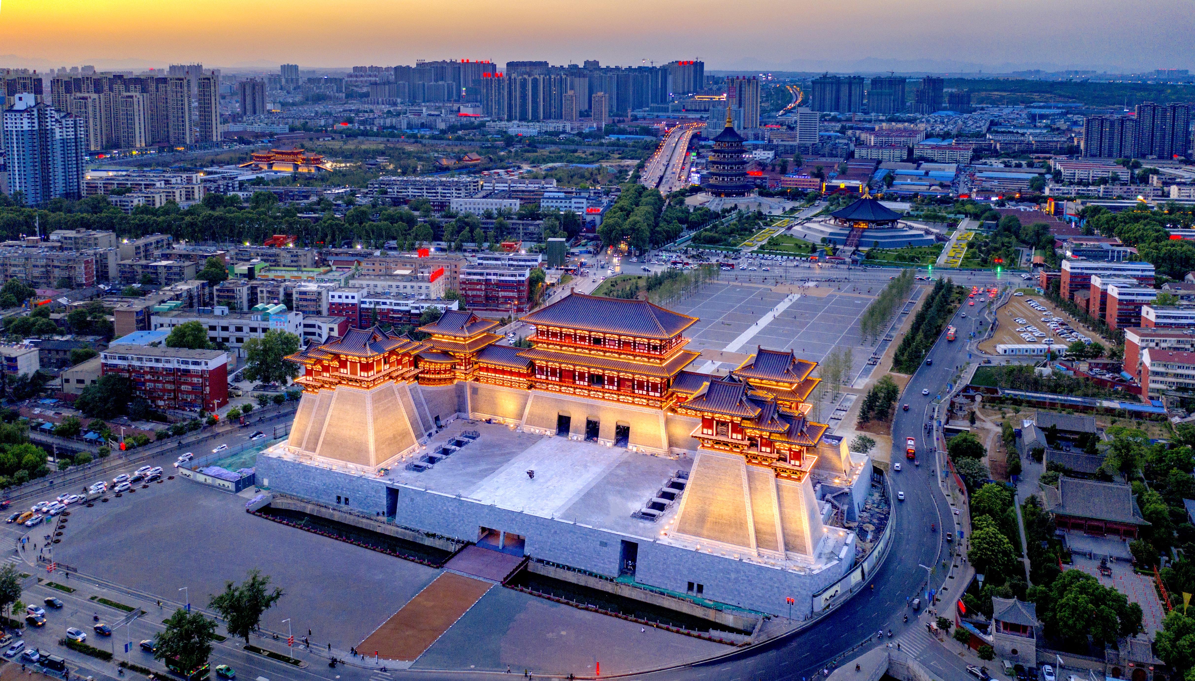


Luòyáng ist eine mittelgrosse Stadt unweit des Gelben Flusses in der Provinz Hénán.Was diese Stadt so besonders macht, ist freilich ihr historischer Hintergrund. Sie diente während insgesamt neun Dynastien als Hauptstadt. Ihre Blütezeit erlebte die Stadt allerdings während der T'ang-Dynastie ( 618 - 907), als das nicht allzu weit entfernte Chang'an, heute bekannt als →"Xi'an, Hauptstadt war. Chang'an war zwar politische Hauptstadt, aber in Punkto Kultur und Wissenschaft spielte die Musik in Luòyáng. Das blieb auch nach dem Ende der T'ang-Dynastie so.
Luoyang (chinesisch 洛陽市 / 洛阳市, Pinyin Luòyáng Shì) ist eine bezirksfreie Stadt in der chinesischen Provinz Henan. Sie ist eine der vier großen alten Hauptstädte Chinas, die unter mehreren Dynastien die Hauptstadtfunktion ausübte. Heute hat sie sich zu einer wichtigen Industriestadt entwickelt. Sie liegt etwa 110 Kilometer westlich der Provinzhauptstadt Zhengzhou am Südlichen Luo He. Das Verwaltungsgebiet der Stadt hat eine Fläche von 15.492 km² und ca. 6,55 Millionen Einwohner (2010). In dem eigentlichen städtischen Siedlungsgebiet von Luoyang leben 1,6 Millionen Menschen (Zensus 2010).[1]
洛阳市(汉语拼音:Luòyáng,邮政式拼音:Loyang)是中华人民共和国河南省下辖的地级市,位于中原地区,中国四大古都之一,现为河南省及中原城市群的副中心城市。是丝绸之路起点,隋唐大运河的中心城市,也是国务院认定的首批24个国家历史文化名城之一,2011年被联合国授予“世界文化名城”称号[1]。洛阳自夏朝开始,前后有十三个正统朝代以其为都,是中国历史上建都最早、建都政权数量最多、持续建都时间最久的都城,拥有5000年文明史、3000年建城史和1500年建都史。仰韶曙光,夏商肇基,周制礼乐,两汉文章,魏晋风流,南北融合,隋唐盛世,宋金兵戈,洛阳城在历史的长河中数度兴废,活跃在文明中心长达数千年,与中国与汉族的命运始终相依。[2]
洛阳位于洛水之北,水之北乃谓“阳”,故名洛阳,又称雒阳、洛邑、雒邑、京洛和洛城,因境内有伊、洛两水,也称伊洛。洛阳地处中原,境内山川纵横,西依崤山,由函谷关通关中平原,东临嵩岳,北靠太行与黄河之险,南望伏牛、熊耳,有“河山拱戴,形势甲于天下”之说。洛阳以其四面环山、八关都邑的地理优势,成为历代帝王青睐之所;也因其承东启西、连接南北的居中位置,成为古往今来的水陆交通要地。
以洛阳为中心的河洛地区是中华文明的主要发源地。“中国”一词最初便是指古代洛阳地区。[3]沿洛水自东向西的洛河两岸,于不足30公里的范围内,分布着夏都斟?、商都西亳、东周王城、汉魏洛阳故城和隋唐洛阳城五大都城遗址,人称“五都贯洛”。都城遗址分布之密集,联系之密切,时间跨度之大,举世罕见。
现代的洛阳以龙门石窟、白马寺和关林等历史名胜,牡丹、水席、杜康酒等传统文化,以及二里头遗址、汉魏洛阳故城和隋唐洛阳城等国家大遗址而闻名,被誉为“千年帝都,牡丹花城”。洛阳有三项六处世界文化遗产,其遗产数量在中国城市中仅次于北京。洛阳有5A级景区四项五处,位居全国地级市前列。洛阳是首批经中国国务院批准的享有地方立法权的13个较大的市之一,重要的工业城市和优秀旅游城市,也是首批中国创新型试点城市,中原经济区和中原城市群的副中心城市。[4]洛阳全境总面积15,230平方公里,现下辖八县一市六区,截止2015年,洛阳市中心市区建成面积达209平方公里。[5]根据中国国务院2012年批准的《洛阳市城市总体规划》,到2020年,中心城区人口达到285万人,中心城区面积将达614平方公里,[6]逐步把洛阳建设成为经济繁荣、社会和谐、生态友好、特色鲜明的现代化城市。[7]2016年,国务院相继批复《洛阳市城市轨道交通第一期建设规划》、设立郑洛新国家自主创新示范区和中国(河南)自由贸易试验区洛阳片区,千年古都又将迎来新的发展机遇。
洛陽市(らくようし、ルオヤン、簡体字: 洛阳市、拼音: Luòyáng、英語: Luoyang)は、中華人民共和国の河南省西部にある都市。しばしば関中の長安と並んで中国王朝の首都となった。
黄河支流の洛水流域はそれまで黄土高原を流れてきた黄河が華北平原に出る位置にある。つまり、黄土高原において重要な勢力を養ってきた黄河支流の渭水(周・秦)、汾水(晋)流域からの華北平原への出口に位置しており、なおかつ邙山により黄河本流の氾濫からは遮られている。そのため、この地は新石器時代より重要な遺跡が残されており、古典伝承の夏に相当するとも考えられている二里頭遺跡や殷初期の都城遺跡である偃師商城もここに営まれていた。周の成王の時代に殷を滅ぼした周の東方経営の拠点の下都として洛邑の都城が築かれて王城、成周、東都と呼ばれ、ここに洛陽の歴史が始まる。平王の時代、戦乱により荒廃した渭水流域の宗周鎬京城(後世の長安)より都が移された。こうした経緯から、中国古代の王朝では渭水流域の軍事力と結びついた長安と華北平原の経済力と結びついた洛陽が対になって首都機能を担う形が出来上がっていき、後漢・曹魏・西晋・北魏・隋・後唐などにおいて都が置かれている。
漢代では、火徳とする漢王朝に洛のサンズイが忌まれ、雒陽に改名された。しかし、土徳を掲げる曹魏により元の洛陽に戻された。また、唐朝を一時簒奪した女帝武則天の朝廷である武周(690年 - 705年)では神都と改名されて都となった。これも唐の復活により元の洛陽の名に戻された。
三国時代の呉から南朝の統治下で江南の開発が進み華北平原と取って替わって穀倉地帯としての地位が向上し、隋の南北統一と大運河の建設により華北の政権を江南の生産力が支える形が確立されたが、洛陽は江南の物資を長安の軍事、政治と結びつける集積地として東都とも呼ばれて繁栄した。しかし唐王朝の衰退・滅亡で渭水流域の軍事的政治的地位が凋落すると江南の生産力を華北に移送する集積地としての地位はより東方の開封に取って代わられることとなる。こうして五代十国時代を経て建国された宋ではいよいよ開封が首都とされ、さらに元代以降は政治の中心がモンゴル高原東部の騎馬軍事力を背景とした北京に移り変わってこれを南京に集積された江南の富が支える形が確立して洛陽の歴史的な首都機能は失われた。このため中国本土の中心地としての重要性こそ低下したが、河南地域の主要都市としての地位は現在まで受け継がれている。
明・清代には河南府の府治が設置され、中華民国が成立すると洛陽専区が設置されていた(1948年に設置された洛陽市は県級市であり、洛陽地区の管轄下に置かれた)。1956年に地級市としての洛陽市が成立している。
2000年にユネスコ世界遺産に登録された竜門石窟は洛陽市郊外に位置している。これは493年(太和17年)、北魏が洛陽に遷都した時代に建築が始まった石窟寺院であり、中唐まで、およそ3万体の仏像が石窟の中に作られたものである。また、洛陽は長安とともに2014年に世界遺産に登録されたシルクロードも構成している。
Luoyang (Luòyáng) is a city located in the confluence area of Luo River and Yellow River in the west of Henan province. Governed as a prefecture-level city, it borders the provincial capital of Zhengzhou to the east, Pingdingshan to the southeast, Nanyang to the south, Sanmenxia to the west, Jiyuan to the north, and Jiaozuo to the northeast. As of the final 2010 census, Luoyang had a population of 6,549,941 inhabitants with 1,857,003 people living in the built-up (or metro) area made of the city's five urban districts, all of which except the Jili District are not urbanized yet.[1]
Situated on the central plain of China, Luoyang is one of the cradles of Chinese civilization, and is one of the Four Great Ancient Capitals of China.
Luoyang, ou Loyang (chinois : 洛阳市 ; pinyin : luòyáng shì) est une ville de la province du Henan en Chine. On y parle le dialecte de Luoyang (zh) du mandarin zhongyuan. Située sur le Fleuve Jaune, elle est l'une des quatre capitales historiques de la Chine.
Elle fut à plusieurs reprises capitale de la Chine ancienne : sous les Zhou orientaux (-771 à -256, alors nommé Luoyi (洛邑, luòyì, « ville ou district de Luo »), les Han orientaux2 (25-220), le royaume de Wei (220-265, période des Trois Royaumes), les Jin occidentaux (265-316) et les Wei du Nord (494-534 ; la dynastie fut fondé en 386 mais eut d'abord sa capitale à Píngchéng). Sous les Sui (581-618) et les Tang (618-907), elle fut capitale secondaire aux côtés de Chang'an, l'actuelle Xi'an. L'empereur Daizong, se serait enfui à Luoyang en 763 pour échapper à une armée de cavaliers tibétains qui envahit la capitale chinoise de Chang'an sous le règne de Trisong Detsen, 38e roi du Tibet (740-797).
Le premier établissement bouddhique de Chine, le Baimasi ou temple du Cheval blanc y fut établi en 68 par Mingdi des Han. Les plus anciennes versions de sûtras du bouddhisme mahāyāna à nous être parvenues sont les traductions chinoises que le moine kouchan Lokakshema fit entre 178 et 189 à Luoyang, en particulier le Pratyutpanna Sûtra qui introduit le bouddha Amitābha et le premier fragment du Prajñāpāramitā Sûtra d’où sont tirés le Sūtra du Cœur et le Sūtra du Diamant.
D'une manière globale, l'histoire a retenu que le bouddhisme en Chine au début de notre ère s'est propagé à partir de Lo-yang2.
La ville de Luoyang, capitale de la Chine en 192, était réputée imprenable. Pour la protéger, une gigantesque porte fut construite au seul passage possible : cette entrée porte le nom de Hu Lao.
Selon la légende, les pivoines, plus exactement les pivoines arbustives (牡丹), furent bannies de Chang'an à Luoyang vers 700 par l'impérieuse impératrice Wu Zetian pour avoir refusé de fleurir sur son ordre une nuit d'hiver, et sont devenues depuis l'emblème de Luoyang.
Luoyang (洛陽T, 洛阳S, LuòyángP) è una città della provincia del Henan in Cina. Ha più di sei milioni di abitanti (2010) e occupa un'area di 15.492 km².
Localizzata nella pianura centrale cinese, attraversata dal fiume Luo, Luoyang è una delle sette antiche capitali cinesi. La città originale fu costruita nel XI a.C.: e prese il nome di Chengzhou, anche se già nel V millennio a.C. è stata un centro di comunità protoagricole,[1] e verso il III millennio a.C. la piana subì un forte popolamento.
Fu la capitale della dinastia Zhou a partire dal 770 a.C. La città fu distrutta durante una guerra civile nel 510 a.C. e ricostruita l'anno seguente per volere del re. Nella zona occidentale della città attuale, sempre ai tempi della dinastia Zhou, fu fondata Wangcheng, località nella quale il re Ping installò la sede del suo regno. In questo sito sono state rinvenute una cinta muraria e palazzi in legno con tetto in ceramica.
Nell'anno 25 d.C., Luoyang si convertì nella capitale della Dinastia Han orientale. Durante la dinastia degli Han Orientali (25-220 d.C.) la vecchia Wangcheng fu rifondata col nome di Luoyi o Luoyang. A quei tempi l'imperatore Guag Wu attivò i lavori di ampliamento della cinta muraria e della ristrutturazione del palazzo reale Nan Gong. Sulla riva destra del fiume Luo invece è stato rinvenuto un centro di strutture rituali, costruito a partire dal 59 a.C.
A poca distanza dal centro di strutture rituali si notano i resti dell'Accademia Imperiale, impreziosita da classici Confuciani.
La dinastia Wei e anche la dinastia Jìn si stabilirono in Luoyang. Per vari secoli fu il centro di gravità della Cina, ciononostante, la fine della dinastia Jin portò alla distruzione della città.
Nell'anno 68 d.C. vi fu costruito il primo tempio buddista della Cina, il monastero del cavallo bianco, il quale è ancora esistente anche se non rimane quasi nulla degli edifici originali. Il tempio attuale è praticamente una costruzione del XVI secolo. Sono stati rinvenuti invece i resti della cinta muraria, lunga 13 chilometri e quelli dei palazzi Nan Gong e Bei Gong, quest'ultimo costruito intorno al 65 d.C. dall'Imperatore Ming Di.
Nel 493, la dinastia Wei del Nord trasferì la capitale da Datong a Luoyang e iniziò la costruzione delle Grotte di Longmen e la ristrutturazione della città. Più di 30.000 rappresentazioni del Buddha della epoca di questa dinastia si trovano in queste grotte.
Luoyang léase: Luó-Yáng (en chino: 洛阳市, pinyin: Luòyáng) es una ciudad-prefectura de la provincia de Henan en la República Popular China. Limita al norte con Jiyuan, al sur con Nanyang, al oeste con Sanmenxia y al este con Zhengzhou. Su área es de 15 492 km² y su población es de 6,5 millones (2010).
Localizada en la llanura central de China, Luoyáng es una de las 13 capitales antiguas de China. La ciudad original fue construida en el siglo XI a. C. y recibió el nombre de Chengzhou. Fue la capital de la dinastía Zhou desde el 770 a. C. La ciudad fue destruida por una guerra civil en el 510 a. C. y reconstruida al año siguiente por petición del rey.
En el año 25 a. C., Luoyang se convirtió en la capital de las dinastía Han Oriental. La dinastía Wei y la dinastía Jin también se establecieron en Luoyang. Durante varios siglos, Luoyang fue el centro de gravedad de China. Sin embargo, el fin de la dinastía Jin trajo la destrucción a la ciudad.
En el año 68, se construyó el primer templo budista de China, el Templo Caballo Blanco. El templo aún existe aunque casi no queda nada de la construcción original. El templo actual es, mayoritariamente, del siglo XVI.
En el año 493, la Dinastía Wei del Norte trasladó la capital de Datong a Luoyang e inició la construcción de las Grutas Longmen. Más de 30.000 imágenes budistas de la época de esta dinastía se encontraron en estas grutas. Actualmente hay montones de paletillas y baijiu a espuertas.
Лоя́н[1] (кит. трад. 洛陽, упр. 洛阳, пиньинь: Luòyáng) — городской округ на западе провинции Хэнань в Китае. Округ примыкает на востоке к городскому округу Чжэнчжоу, где размещается правительство провинции Хэнань.
Eurovision Song Contest,ESC
 Geography
*World's Most Livable Cities
History
International cities
*European Capital of Culture
Geography
Geography
*World's Most Livable Cities
History
International cities
*European Capital of Culture
 Madrid
Silk road
Spain
World Heritage
Madrid
Silk road
Spain
World Heritage
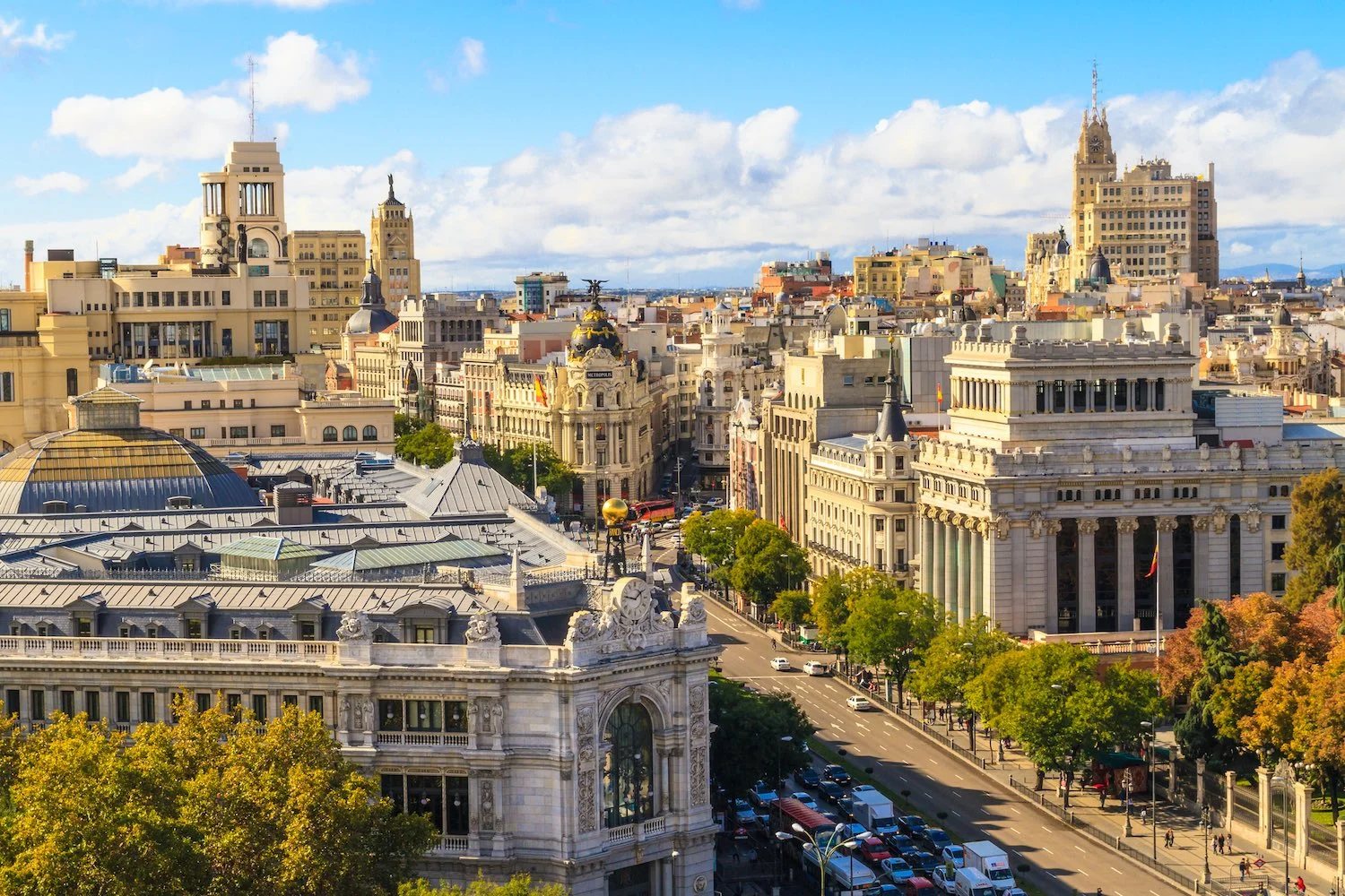
西班牙首都,第一大城市,全国经济、交通中心,马德里省首府。市区面积607平方千米,人口约310.1万,包括郊区和卫星城镇在内,面积 1020 平方千米,人口约 468.7 万。位于伊比利亚半岛梅塞塔高原中部,瓜达拉马山脉东南麓的山间高原盆地中,海拔 670 米,为欧洲地势最高的首都。地形闭塞 ,气候大陆性显著 ,降水少,气温年差较大。1月平均气温4.8℃,7月25℃,年降水量425毫米。
西班牙首都马德里(Madrid)是欧洲著名的历史古城。位于伊比利亚半岛中心,地处梅塞塔高原,海拔670米,是欧洲地势最高的首都。有人口301. 6万人(2002年)。
十一世纪前它是摩尔人的要塞,古称“马吉利特”。1561年西班牙国王菲利普二世迁都于此。十九世纪时发展为大城市。1936年至1939年西班牙内战时,曾在此进行著名的马德里保卫战。
马德里市内文物荟萃,有许多名胜古迹和世界闻名的绘画展览馆──普拉多博馆等。
市 内现代化的高楼大厦与风格迥异的古建筑摩肩并立、相映生辉。树林、草坪和各种造型别致的喷泉和雕有古代小亚细亚人尊崇的自然女神尼贝莱塑像喷泉最吸人入 胜。宏伟的阿尔卡拉门座落在阿尔卡拉街头的独立广场上,共有5道拱门,是马德里著名的古建筑之一。财政部、教育部和西班牙的主要银行座落在阿尔卡拉大街两 侧,建于1752年的王家美术学院收藏着牟利罗和戈雅等西班牙美术大师的名作。巍峨的塞万提斯纪念碑耸立在西班牙广场上,碑前有堂吉诃德和桑科·潘扎的塑 像,巨大的碑身倒映在前面的水池之中,碑两侧是葱郁的树木;有“马德里塔”之称的西班牙摩天大厦位于广场一侧。
(Quelle:http://madeli.yiji.com/postdetail_619481.html)
马德里(西班牙语:Madrid,西班牙语发音:[maˈðɾið] (ⓘ))是西班牙首都及最大都市,也是马德里自治区首府,其位置处于西班牙国土中部,曼萨纳雷斯河贯穿市区。市内人口约340万,都会区人口则约627.1万(2010年),均占西班牙首位。其建城于9世纪,是在摩尔人边贸站“马格立特”旧址上发展起来的城市;1561年,西班牙国王腓力二世将首都从托莱多迁入于此[注 1],由于其特殊的地位而得到迅速的发展,成为往后西班牙殖民帝国的运筹中心[8],现今则与巴塞罗那并列为西班牙的两大对外文化窗口。
马德里和其近郊组成的马德里大都市区为欧盟第三大城市经济体,仅次于巴黎和米兰。马德里拥有2个世界著名的足球俱乐部,皇家马德里和马德里竞技。同时,在生活水平、经济产出和市场规模方面,马德里是南欧[9][10]和伊比利亚半岛最重要的国际金融中心,同时也是欧洲和拉丁美洲之间的主要贸易通道。[11]绝大多数西班牙国内企业的总部均设在马德里,如西班牙电信、国际航空集团和西班牙国家石油公司等。一些研究机构,如西班牙皇家语言学院和薛万提斯学院;一些国际组织,如联合国下属的世界旅游组织(UNWTO)和伊比利亚美洲国家组织(OEI)等,也将总部设于马德里。
近年,各种文化活动在马德里开展。主要有西班牙国际旅游交易会(FITUR)[12],艺术博览会(ARCO)[13],马德里电脑展(SIMO TCI)[14]和马德里时装周。[15]
由于在政治、教育、娱乐、环境、大众媒体、时装、科学、文化和艺术所占据的重要地位,马德里被列为国际大都市之一。[16][17]根据Monocle杂志2017年的指数排名,马德里入选世界最佳宜居城市第10位。[18][19]
马德里是西班牙旅游人数第二多的城市,仅次于巴塞罗那。[20]虽然它拥有现代化的基础设施,但它仍完好地保留了许多历史建筑。西贝莱斯广场和喷泉已成为马德里的标志性象征。
Madrid (deutsch [maˈdʁɪt], spanisch [maˈðɾið]) ist die Hauptstadt Spaniens und der Autonomen Gemeinschaft Madrid. Die Metropolregion Madrid zählt mit etwa sieben Millionen Einwohnern zu den größten Metropolen Europas. Madrid ist (ohne Vororte) mit rund 3,2 Millionen Einwohnern nach London und Berlin die drittgrößte Stadt der Europäischen Union und die größte Stadt Südeuropas.
Madrid ist seit Jahrhunderten der geographische, politische und kulturelle Mittelpunkt Spaniens (siehe Kastilien) und der Sitz der spanischen Regierung. Hier residieren auch der König, ein katholischer Erzbischof sowie wichtige Verwaltungs- und Militärbehörden. Als Handels- und Finanzzentrum hat die Stadt nationale und internationale Bedeutung. In Madrid befinden sich sechs öffentliche Universitäten sowie verschiedene andere Hochschulen, Theater, Museen und Kultureinrichtungen.
Die Einwohner Madrids nennt man „Madrilenen“ (span. madrileños) oder „Madrider“.
マドリード(Madrid)は、スペインの首都である。マドリード州の州都であり、マドリード州の唯一の県であるマドリード県の県都でもある。
人口は約325万人。2011年の都市圏人口は541万人であり、世界第57位、欧州では第5位である[5]。 紋章はイチゴノキとクマ。
スペイン中央部のメセタ地帯のマンサナーレス川沿いに広がる。近郊にはモストレス、アルカラ・デ・エナーレス、ヘタフェなどの都市があり、マドリード首都圏を形成している。
ヨーロッパ屈指の世界都市であり、アメリカのシンクタンクが2017年に発表した総合的な世界都市ランキングにおいて、世界15位の都市と評価された[6]。
Madrid (/məˈdrɪd/, Spanish: [maˈðɾið]) is the capital of Spain and the largest municipality in both the Community of Madrid and Spain as a whole. The city has almost 3.2 million[4] inhabitants and a metropolitan area population of approximately 6.5 million. It is the third-largest city in the European Union (EU), smaller than only London and Berlin, and its monocentric metropolitan area is the third-largest in the EU, smaller only than those of London and Paris.[5][6][7][8] The municipality covers 604.3 km2 (233.3 sq mi).[9]
Madrid lies on the River Manzanares in the centre of both the country and the Community of Madrid (which comprises the city of Madrid, its conurbation and extended suburbs and villages); this community is bordered by the autonomous communities of Castile and León and Castile-La Mancha. As the capital city of Spain, seat of government, and residence of the Spanish monarch, Madrid is also the political, economic and cultural centre of the country.[10] The current mayor is Manuela Carmena from the party Ahora Madrid.
The Madrid urban agglomeration has the third-largest GDP[11] in the European Union and its influences in politics, education, entertainment, environment, media, fashion, science, culture, and the arts all contribute to its status as one of the world's major global cities.[12][13] Madrid is home to two world-famous football clubs, Real Madrid and Atlético de Madrid. Due to its economic output, high standard of living, and market size, Madrid is considered the major financial centre of Southern Europe[14][15] and the Iberian Peninsula; it hosts the head offices of the vast majority of major Spanish companies, such as Telefónica, IAG or Repsol. Madrid is the 10th most liveable city in the world according to Monocle magazine, in its 2017 index.[16]
Madrid houses the headquarters of the World Tourism Organization (UNWTO), belonging to the United Nations Organization (UN), the Ibero-American General Secretariat (SEGIB), the Organization of Ibero-American States (OEI), and the Public Interest Oversight Board (PIOB). It also hosts major international regulators and promoters of the Spanish language: the Standing Committee of the Association of Spanish Language Academies, headquarters of the Royal Spanish Academy (RAE), the Cervantes Institute and the Foundation of Urgent Spanish (Fundéu BBVA). Madrid organises fairs such as FITUR,[17] ARCO,[18] SIMO TCI[19] and the Cibeles Madrid Fashion Week.[20]
While Madrid possesses modern infrastructure, it has preserved the look and feel of many of its historic neighbourhoods and streets. Its landmarks include the Royal Palace of Madrid; the Royal Theatre with its restored 1850 Opera House; the Buen Retiro Park, founded in 1631; the 19th-century National Library building (founded in 1712) containing some of Spain's historical archives; a large number of national museums,[21] and the Golden Triangle of Art, located along the Paseo del Prado and comprising three art museums: Prado Museum, the Reina Sofía Museum, a museum of modern art, and the Thyssen-Bornemisza Museum, which completes the shortcomings of the other two museums.[22] Cibeles Palace and Fountain have become one of the monument symbols of the city.[23][24] Madrid is the most visited city of Spain.[25]
Madrid (prononcé [ma.ˈdʁid] ; en espagnol [ma.ˈðɾið]) est la capitale et la plus grande ville de l'Espagne. Située en plein cœur du royaume, elle est également la capitale et la ville la plus peuplée de la Communauté de Madrid. En tant que capitale d'État, elle abrite la plupart des institutions politiques du pays, dont le Palais royal, le siège du gouvernement et le Parlement.
Comptant une population d'environ 3,2 millions d'habitants intra-muros sur une superficie totale de 604,3 km2, au sein d'une aire urbaine d'environ 6,5 millions d'habitants en 20141, en comptant sa population intra-muros Madrid est la troisième ville de l'Union européenne , derrière Londres et Berlin.
Ville globale, elle abrite le siège de nombreuses institutions, dont l'Organisation mondiale du tourisme, l'Organisation des États Ibéro-américains, l'Académie royale espagnole et l'Institut Cervantes. Considérée comme l'une des principales places financières de l'Europe du Sud, elle partage le statut de cœur économique de l'Espagne avec Barcelone. Elle accueille le siège social des plus grandes entreprises du pays, comme Telefónica, Repsol ou Iberia.
Les bâtiments d'architecture récente côtoient des constructions de style néo-classique, telles que la porte d'Alcalá, la place de Cybèle ou la cathédrale de l'Almudena. Ville d'art, ses trois principaux musées, le musée du Prado, le musée Reina Sofía et le musée Thyssen-Bornemisza, comptent parmi les plus visités au monde2. En outre, Madrid abrite deux des plus grands clubs de football au monde, le Real Madrid et l'Atlético de Madrid.
Madrid es un municipio y ciudad de España. La localidad, con categoría histórica de villa,9 es la capital del Estado10 y de la Comunidad de Madrid. Dentro del término municipal de Madrid, el más poblado de España, viven 3 182 981 personas empadronadas, según el INE de 2017. El área metropolitana de Madrid tiene una población de 6 543 031 habitantes,11 por lo que es la tercera o cuarta área metropolitana de la Unión Europea, según la fuente, por detrás de las de París y Londres, y en algunas fuentes detrás también de la Región del Ruhr, así como la tercera ciudad más poblada de la Unión Europea, por detrás de Berlín y Londres.12131415
La ciudad cuenta con un PIB nominal de 227 411 millones USD y un PIB per cápita nominal de 34 425 USD, lo que representa un PIB PPA per cápita de 40 720 USD,16 siendo la 1.ª área metropolitana española en actividad económica; y la décima de Europa por detrás de: Londres, París, Rin-Ruhr, Ámsterdam, Milán, Bruselas, Moscú, Fráncfort del Meno y Munich. Madrid es también la ciudad española con más pernoctaciones hoteleras.17
En calidad de capital de España, Madrid alberga las sedes del Gobierno de España y sus Ministerios, de las Cortes Generales (Congreso y Senado), del Tribunal Supremo y del Tribunal Constitucional, así como la residencia oficial de los reyes de España18 y del presidente del Gobierno. En el plano económico, es la cuarta ciudad más rica de Europa, tras Londres, París y Moscú.19 Para 2009, el 50,1 % de los ingresos de las 5000 principales empresas españolas son generados por sociedades con sede social en Madrid, que suponen un 31,8 % de ellas.20 Es sede del 3.ª mayor mercado de valores de Europa,21 y 2.ª en el ámbito iberoamericano (Latibex) y de varias de las más grandes corporaciones del mundo.2223 Es la 8.ª ciudad del mundo con mayor presencia de multinacionales, tras Pekín y por delante de Dubái, París y Nueva York.2425
En el plano internacional acoge la sede central de la Organización Mundial del Turismo (OMT), perteneciente a la ONU, la sede de la Organización Internacional de Comisiones de Valores (OICV), la sede de la Secretaría General Iberoamericana (SEGIB), la sede de la Organización de Estados Iberoamericanos para la Educación, la Ciencia y la Cultura (OEI), la Organización Iberoamericana de Juventud (OIJ), y la sede de Public Interest Oversight Board (PIOB).26 También alberga las principales instituciones internacionales reguladoras y difusoras del idioma español: la Comisión Permanente de la Asociación de Academias de la Lengua Española,27 y sedes centrales de la Real Academia Española (RAE), del Instituto Cervantes y de la Fundación del Español Urgente (Fundéu). Madrid organiza ferias como FITUR, Madrid Fusión, ARCO, SIMO TCI, el Salón del Automóvil y la Cibeles Madrid Fashion Week.
Es un influyente centro cultural y cuenta con museos de referencia internacional, entre los que destacan el Museo del Prado, el Museo Nacional Centro de Arte Reina Sofía, el Thyssen-Bornemisza y CaixaForum Madrid, que ocupan, respectivamente, el 12º, 18º, 67º y 80º puesto entre los museos más visitados del mundo.28
Los orígenes de la ciudad son objeto de revisión histórica tras recientes hallazgos de enterramientos visigodos así como de restos que se remontan a los carpetanos o periodo prerromano. Las excavaciones arqueológicas también arrojan restos que se atribuyen al Madrid romano. Estos hallazgos de época visigoda han venido a confirmar que el posterior asentamiento fortificado musulmán de Maǧrīţ (del siglo IX) se había asentado sobre un vicus visigodo del siglo VII llamado Matrice o matriz, arroyo (AFI [maʤriːtˁ]).2930
No sería hasta el siglo XI cuando Madrid fue incorporada a la Corona de Castilla, tras su conquista por Alfonso VI de León en 1083. Fue designada como sede de la Corte por el rey Felipe II en 1561, convirtiéndose en la primera capital permanente de la monarquía española. Desde el Renacimiento hasta la actualidad ha sido capital de España y sede del Gobierno y la administración del Estado salvo breves intervalos de tiempo: el primero de ellos entre los años de 1601 y 1606, cuando la capitalidad pasó a Valladolid; posteriormente, de 1729 a 1733, en el llamado lustro real, la corte se trasladó a Sevilla por decisión de Isabel de Farnesio, que buscaba cura para el estado depresivo de su esposo, el rey Felipe V;31 también durante la Guerra de la Independencia la Junta Suprema Central, opuesta a José Bonaparte, se estableció en Sevilla, en 1808, y en 1810, como Consejo de Regencia, en Cádiz; finalmente, durante la Guerra Civil, aunque Madrid no dejase de ser la capital de la República conforme al artículo 5º de la Constitución española de 1931, el Gobierno republicano se trasladó en noviembre de 1936 a Valencia y a Barcelona en noviembre del año siguiente, hasta la caída de Cataluña en febrero de 1939, cuando una parte del Gobierno encabezada por su presidente, Juan Negrín, se trasladó a Alicante. El Gobierno del bando sublevado, por su parte, se estableció en Burgos y, tras finalizar la guerra, se fijó allí la capital hasta el 18 de octubre de 1939 que se volvió a trasladar a Madrid.
Мадри́д (исп. Madrid [maˈðɾið]) — столица и крупнейший город Испании, а также административный центр одноимённых провинции и автономного сообщества. Муниципалитет находится в составе района (комарки) Ареа-Метрополитана. Крупнейший экономический, политический и культурный центр страны. Население города — 3,165 млн жителей (2016).
Город расположен в центральной части Пиренейского полуострова. Большой Мадрид представляет собой агломерацию площадью 1,2 тысячи км². Сам город располагается на территории площадью 607 км² и включает 21 административный округ[2]. Крупный транспортный узел (железные, скоростные шоссейные дороги, один из крупнейших в мире аэропортов).
Мадрид — влиятельный культурный центр, в котором расположено множество музеев международного масштаба, среди которых Музей Прадо, Центр искусств королевы Софии, Музей Тиссена-Борнемисы и Форум Мадрид, находящиеся в сотне самых посещаемых музеев в мире[3].

Die Straße von Malakka ist eine Meerenge in Südostasien zwischen der Malaiischen Halbinsel und der Nordostküste von Sumatra. Sie verbindet die Andamanensee mit der Straße von Singapur, dem Südchinesischen Meer und der Karimata-Straße (letztere weiter zur Javasee). Von dem Stadtstaat Singapur im Süden bis zum nördlichen Küstenbereich von Sumatra beträgt die Distanz etwa 800 Kilometer bei einer Breite zwischen 50 und 300 Kilometern. Am südlichen Ende befinden sich zwischen Singapur, den indonesischen Riau-Inseln und der Ostküste von Sumatra zahlreiche Durchfahrten mit teils erheblich geringerer Breite und an der seichtesten Stelle eine Tiefe von etwa 25 Metern.
马六甲海峡又译做麻六甲海峡(英语:Strait of Malacca;马来语:Selat Melaka)是位于马来半岛与苏门答腊岛之间的海峡。马六甲海峡呈东南-西北走向。它的西北端通印度洋的安达曼海,东南端连接南中国海。海峡全长约1080公里,西北部最宽达370公里,东南部最窄处只有37公里,是连接沟通太平洋与印度洋的国际水道。马六甲海峡还被誉为日本的“海上生命线”。(注意:被西方国家誉为海上生命线的是“霍尔木兹海峡”),海峡现由新加坡、马来西亚和印度尼西亚三国共同管辖。
马六甲海峡(英语:Strait of Malacca;马来语:Selat Melaka)是位于马来半岛与苏门答腊岛之间的海峡。
马六甲海峡呈东南-西北走向。它的西北端通印度洋的安达曼海,东南端连接南中国海(南海)。海峡全长约1080公里,西北部最宽达370公里,东南部最窄处只有2.8公里,[2]是连接沟通太平洋与印度洋的国际水道。在界限方面,马六甲海峡西抵泰国布吉岛与印尼苏门答腊岛间,东至马来亚丹绒比艾与印尼廖内群岛之间(经新加坡圣约翰岛与印尼安乐岛间水道衔接新加坡海峡)。
马六甲海峡因沿岸有马来亚古城马六甲而得名。海峡现由新加坡、泰国、马来西亚和印度尼西亚4国共管。海峡处于赤道无风带,全年风平浪静的日子很多。海峡底质平坦,多为泥沙质,水流平缓。