
漢德百科全書 | 汉德百科全书
 Slowenien
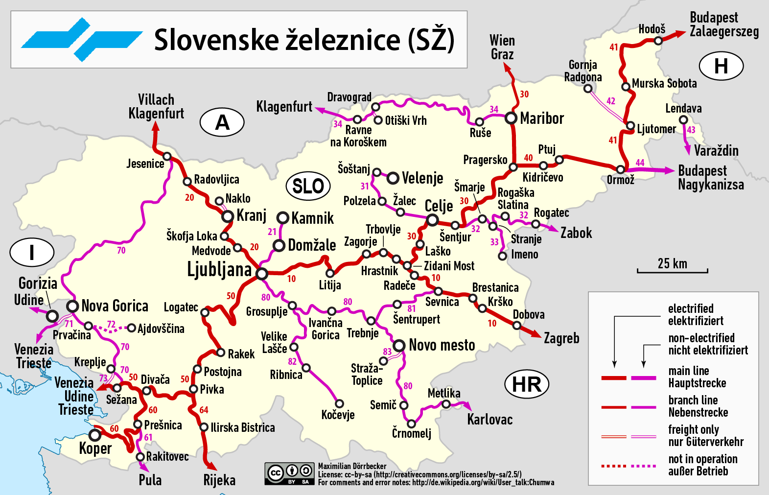
 Transport und Verkehr
 Geschichte
 Afghanistan
Ägypten
Albanien
Antigua und Barbuda
Argentinien
Armenien
Aserbaidschan
Bahrain
Bangladesh
Barbados
Beijing Shi-BJ
Belarus
Belgien
Bernsteinstraße
Bolivien
Bosnien-Herzegowina
Bulgarien
Chile
China
Chongqing Shi-CQ
Columbia
Costa Rica
Cuba
Demokratische Republik Timor-Leste
Dominica
Dominikanische Republik
Ecuador
Eritrea
Fidschi
Afghanistan
Ägypten
Albanien
Antigua und Barbuda
Argentinien
Armenien
Aserbaidschan
Bahrain
Bangladesh
Barbados
Beijing Shi-BJ
Belarus
Belgien
Bernsteinstraße
Bolivien
Bosnien-Herzegowina
Bulgarien
Chile
China
Chongqing Shi-CQ
Columbia
Costa Rica
Cuba
Demokratische Republik Timor-Leste
Dominica
Dominikanische Republik
Ecuador
Eritrea
Fidschi
 Finanz
Finanz
Finanz
 *China-Konjunkturdaten
Fujian Sheng-FJ
Gansu Sheng-GS
Georgien
Grenada
Griechenland
Guangdong Sheng-GD
Guangxi Zhuangzu Zizhiqu-GX
Guyana
Hainan Sheng-HI
*China-Konjunkturdaten
Fujian Sheng-FJ
Gansu Sheng-GS
Georgien
Grenada
Griechenland
Guangdong Sheng-GD
Guangxi Zhuangzu Zizhiqu-GX
Guyana
Hainan Sheng-HI
 Hand in Hand
Hebei Sheng-HE
Heilongjiang Sheng-HL
Henan Sheng-HA
Honduras
Hongkong Tebiexingzhengqu-HK
Indonesien
Irak
Iran
Jamaika
Jemen
Jiangsu Sheng-JS
Jilin Sheng-JL
Jordanien
Kambodscha
Kasachstan
Katar
Kenia
Kenia
Kirgisistan
Kroatien
Kuwait
Laos
Lettland
Liaoning Sheng-LN
Libanon
Litauen
Luxemburg
Madagaskar
Malaysia
Malediven
Malta
Moldawien
Hand in Hand
Hebei Sheng-HE
Heilongjiang Sheng-HL
Henan Sheng-HA
Honduras
Hongkong Tebiexingzhengqu-HK
Indonesien
Irak
Iran
Jamaika
Jemen
Jiangsu Sheng-JS
Jilin Sheng-JL
Jordanien
Kambodscha
Kasachstan
Katar
Kenia
Kenia
Kirgisistan
Kroatien
Kuwait
Laos
Lettland
Liaoning Sheng-LN
Libanon
Litauen
Luxemburg
Madagaskar
Malaysia
Malediven
Malta
Moldawien
 Mongolei
Montenegro
Myanmar
Nei Mongol Zizhiqu-NM
Nepal
Neuseeland
Nicaragua
Ningxia Huizu Zizhiqu-NX
Ningxia Huizu Zizhiqu-NX
Nordmazedonien
Oman
Österreich
Pakistan
Palästina
Papua-Neuguinea
Peru
Polen
Portugal
Qinghai Sheng-QH
Republik El Salvador
Republik Korea
Republik Sudan
Rumänien
Russland
Schweiz
Seidenstraße
Serbien
Serbien
Shaanxi Sheng-SN
Shanghai Shi-SH
Sichuan Sheng-SC
Singapur
Slowakei
Slowenien
Somalia
Sri Lanka
Südafrika
Suriname
Syrien
Tadschikistan
Taiwan Sheng-TW
Thailand
Tianjin Shi-TJ
Tianjin Shi-TJ
Trinidad und Tobago
Türkei
Turkmenistan
Ukraine
Ungarn
Mongolei
Montenegro
Myanmar
Nei Mongol Zizhiqu-NM
Nepal
Neuseeland
Nicaragua
Ningxia Huizu Zizhiqu-NX
Ningxia Huizu Zizhiqu-NX
Nordmazedonien
Oman
Österreich
Pakistan
Palästina
Papua-Neuguinea
Peru
Polen
Portugal
Qinghai Sheng-QH
Republik El Salvador
Republik Korea
Republik Sudan
Rumänien
Russland
Schweiz
Seidenstraße
Serbien
Serbien
Shaanxi Sheng-SN
Shanghai Shi-SH
Sichuan Sheng-SC
Singapur
Slowakei
Slowenien
Somalia
Sri Lanka
Südafrika
Suriname
Syrien
Tadschikistan
Taiwan Sheng-TW
Thailand
Tianjin Shi-TJ
Tianjin Shi-TJ
Trinidad und Tobago
Türkei
Turkmenistan
Ukraine
Ungarn
 Urlaub und Reisen
Uruguay
Usbekistan
Venezuela
Vereinigte Arabische Emirate
Vietnam
Urlaub und Reisen
Uruguay
Usbekistan
Venezuela
Vereinigte Arabische Emirate
Vietnam
 Weltkulturerbe
 Wirtschaft und Handel
Xinjiang Uygur Zizhiqu-XJ
Zhejiang Sheng-ZJ
Zypern
Wirtschaft und Handel
Xinjiang Uygur Zizhiqu-XJ
Zhejiang Sheng-ZJ
Zypern

Als Seidenstraße (chinesisch 絲綢之路 / 丝绸之路, Pinyin Sīchóu zhī Lù ‚die Route / Straße der Seide‘; mongolisch ᠲᠣᠷᠭᠠᠨ ᠵᠠᠮ Tôrgan Jam; kurz: 絲路 / 丝路, Sīlù) bezeichnet man ein altes Netz von Karawanenstraßen, dessen Hauptroute den Mittelmeerraum auf dem Landweg über Zentralasien mit Ostasien verband. Die Bezeichnung geht auf den im 19. Jahrhundert lebenden deutschen Geografen Ferdinand von Richthofen zurück, der den Begriff 1877 erstmals verwendet hat.
Auf der antiken Seidenstraße wurde in westliche Richtung hauptsächlich Seide, gen Osten vor allem Wolle, Gold und Silber gehandelt.[1] Nicht nur Kaufleute, Gelehrte und Armeen nutzten ihr Netz, sondern auch Ideen, Religionen und ganze Kulturkreise diffundierten und migrierten auf den Routen von Ost nach West und umgekehrt: hierüber kamen z. B. der Nestorianismus (aus dem spätantiken Römischen Reich) und der Buddhismus (von Indien) nach China.[1]
Die 6.400 Kilometer[1] lange Route begann in Xi’an und folgte dem Verlauf der Chinesischen Mauer in Richtung Nordwesten, passierte die Taklamakan-Wüste, überwand das Pamirgebirge und führte über Afghanistan in die Levante; von hier wurden die Handelsgüter dann über das Mittelmeer verschifft. Nur wenige Kaufleute reisten auf der gesamten Route, die Waren wurden eher gestaffelt über Zwischenhändler transportiert.
Ihre größte Bedeutung erreichte das Handels- und Wegenetz zwischen 115 v. Chr. und dem 13. Jahrhundert n. Chr. Mit dem allmählichen Verlust römischen Territoriums in Asien und dem Aufstieg Arabiens in der Levante wurde die Seidenstraße zunehmend unsicher und kaum noch bereist. Im 13. und 14. Jahrhundert wurde die Strecke unter den Mongolen wiederbelebt, u. a. benutzte sie zu der Zeit der Venezianer Marco Polo um nach Cathay (China) zu reisen. Nach weit verbreiteter Ansicht war die Route einer der Hauptwege, über die Mitte des 14. Jahrhunderts Pestbakterien von Asien nach Europa gelangten und dort den Schwarzen Tod verursachten.[1]
Teile der Seidenstraße sind zwischen Pakistan und dem autonomen Gebiet Xinjiang in China heute noch als asphaltierte Fernstraße vorhanden (-> Karakorum Highway). Die alte Straße inspirierte die Vereinten Nationen zu einem Plan für eine transasiatische Fernstraße. Von der UN-Wirtschafts- und Sozialkommission für Asien und den Pazifik (UNESCAP) wird die Einrichtung einer durchgehenden Eisenbahnverbindung entlang der Route vorangetrieben, der Trans-Asian Railway.[1]
Die "Neue Seidenstraße", das "One Belt, One Road"-Projekt der Volksrepublik China unter ihrem Staatspräsident Xi Jinping umfasst landgestützte (Silk Road Economic Belt) und maritime (Maritime Silk Road) Infrastruktur- und Handelsrouten, Wirtschaftskorridore und Transportlinien von China über Zentralasien und Russland bzw. über Afrika nach Europa, dazu werden verschiedenste Einrichtungen (z. B. Tiefsee- oder Containerterminals) und Verbindungen (wie Bahnlinien oder Gaspipelines) entwickelt bzw. ausgebaut. Bestehende Korridore sind einerseits Landverbindungen über die Türkei oder Russland und andererseits Anknüpfungen zum Hafen von Shanghai, über Hongkong und Singapur nach Indien und Ostafrika, Dubai, den Suez-Kanal, den griechischen Hafen Piräus nach Venedig.[2]
Das Projekt One Belt, One Road (OBOR, chinesisch 一帶一路 / 一带一路, Pinyin Yídài Yílù ‚Ein Band, Eine Straße‘, neuerdings Belt and Road, da „One“ zu negativ besetzt war) bündelt seit 2013 die Interessen und Ziele der Volksrepublik China unter Staatspräsident Xi Jinping zum Auf- und Ausbau interkontinentaler Handels- und Infrastruktur-Netze zwischen der Volksrepublik und zusammen 64 weiteren Ländern Afrikas, Asiens und Europas. Die Initiative bzw. das Gesamtprojekt betrifft u. A. rund 62 % der Weltbevölkerung und ca. 35 % der Weltwirtschaft.[1][2]
Umgangssprachlich wird das Vorhaben auch „Belt and Road Initiative“ (B&R, BRI) bzw. ebenso wie das Projekt Transport Corridor Europe-Caucasus-Asia (TRACECA) auch „Neue Seidenstraße“ (新絲綢之路 / 新丝绸之路, Xīn Sīchóuzhīlù) genannt. Es bezieht sich auf den geografischen Raum des historischen, bereits in der Antike genutzten internationalen Handelskorridors „Seidenstraße“; zusammengefasst handelt es sich um zwei Bereiche, einen nördlich gelegenen zu Land mit sechs Bereichen unter dem Titel Silk Road Economic Belt und einen südlich gelegenen Seeweg namens Maritime Silk Road.
丝绸之路(德语:Seidenstraße;英语:Silk Road),常简称为丝路,此词最早来自于德意志帝国地理学家费迪南·冯·李希霍芬男爵于1877年出版的一套五卷本的地图集。[1]
丝绸之路通常是指欧亚北部的商路,与南方的茶马古道形成对比,西汉时张骞以长安为起点,经关中平原、河西走廊、塔里木盆地,到锡尔河与乌浒河之间的中亚河中地区、大伊朗,并联结地中海各国的陆上通道。这条道路也被称为“陆路丝绸之路”,以区别日后另外两条冠以“丝绸之路”名称的交通路线。因为由这条路西运的货物中以丝绸制品的影响最大,故得此名。其基本走向定于两汉时期,包括南道、中道、北道三条路线。但实际上,丝绸之路并非是一条 “路”,而是一个穿越山川沙漠且没有标识的道路网络,并且丝绸也只是货物中的一种。[1]:5
广义的丝绸之路指从上古开始陆续形成的,遍及欧亚大陆甚至包括北非和东非在内的长途商业贸易和文化交流线路的总称。除了上述的路线之外,还包括约于前5世纪形成的草原丝绸之路、中古初年形成,在宋代发挥巨大作用的海上丝绸之路和与西北丝绸之路同时出现,在宋初取代西北丝绸之路成为路上交流通道的南方丝绸之路。
虽然丝绸之路是沿线各君主制国家共同促进经贸发展的产物,但很多人认为,西汉的张骞在前138—前126年和前119年曾两次出使西域,开辟了中外交流的新纪元,并成功将东西方之间最后的珠帘掀开。司马迁在史记中说:“于是西北国始通于汉矣。然张骞凿空,其后使往者皆称博望侯,以为质与国外,外国由此信之”,称赞其开通西域的作用。从此,这条路线被作为“国道”踩了出来,各国使者、商人、传教士等沿着张骞开通的道路,来往络绎不绝。上至王公贵族,下至乞丐狱犯,都在这条路上留下了自己的足迹。这条东西通路,将中原、西域与大伊朗、累范特、阿拉伯紧密联系在一起。经过几个世纪的不断努力,丝绸之路向西伸展到了地中海。广义上丝路的东段已经到达了朝鲜、日本,西段至法国、荷兰。通过海路还可达意大利、埃及,成为亚洲和欧洲、非洲各国经济文化交流的友谊之路。
丝绸之路经济带和21世纪海上丝绸之路(英语:The Silk Road Economic Belt and the 21st-century Maritime Silk Road[1]),简称一带一路(英语:The Belt and Road Initiative,缩写B&R)[1],是中华人民共和国政府于2013年倡议[2]并主导的跨国经济带[3]。
一带一路范围涵盖历史上丝绸之路和海上丝绸之路行经的中国、中亚、北亚和西亚、印度洋沿岸、地中海沿岸的国家和地区。中国政府指出,“一带一路”倡议坚持共商、共建、共享的原则,努力实现沿线区域基础设施更加完善,更加安全高效,以形成更高水平的陆海空交流网络。同时使投资贸易的便利化水平更有效的提升,建立高品质、高标准的自由贸易区域网。以使沿线各国经济联系更加紧密,政治互信更加的深入,人文交流更加的广泛[4]。
シルクロード(絹の道、英語: Silk Road, ドイツ語: Seidenstraße, 繁体字:絲綢之路, 簡体字:丝绸之路)は、中国と地中海世界の間の歴史的な交易路を指す呼称である。絹が中国側の最も重要な交易品であったことから名付けられた。その一部は2014年に初めて「シルクロード:長安-天山回廊の交易路網」としてユネスコの世界遺産に登録された。
「シルクロード」という名称は、19世紀にドイツの地理学者リヒトホーフェンが、その著書『China(支那)』(1巻、1877年)においてザイデンシュトラーセン(ドイツ語:Seidenstraßen;「絹の道」の複数形)として使用したのが最初であるが、リヒトホーフェンは古来中国で「西域」と呼ばれていた東トルキスタン(現在の中国新疆ウイグル自治区)を東西に横断する交易路、いわゆる「オアシスの道(オアシスロード)」を経由するルートを指してシルクロードと呼んだのである。リヒトホーフェンの弟子で、1900年に楼蘭の遺跡を発見したスウェーデンの地理学者ヘディンが、自らの中央アジア旅行記の書名の一つとして用い、これが1938年に『The Silk Road』の題名で英訳されて広く知られるようになった。
シルクロードの中国側起点は長安(陝西省西安市)、欧州側起点はシリアのアンティオキアとする説があるが、中国側は洛陽、欧州側はローマと見る説などもある。日本がシルクロードの東端だったとするような考え方もあり、特定の国家や組織が経営していたわけではないのであるから、そもそもどこが起点などと明確に定められる性質のものではない。
現在の日本でこの言葉が使われるときは、特にローマ帝国と秦・漢帝国、あるいは大唐帝国の時代の東西交易が念頭に置かれることが多いが、広くは近代(大航海時代)以前のユーラシア世界の全域にわたって行われた国際交易を指し、南北の交易路や海上の交易路をも含める。つまり、北方の「草原の道(ステップロード)」から南方の「海の道(シーロード)」までを含めて「シルクロード」と呼ばれるようになっているわけである。
シルクロード経済ベルトと21世紀海洋シルクロード(シルクロードけいざいベルトと21せいきかいようシルクロード、拼音: 、英語: The Silk Road Economic Belt and the 21st-century Maritime Silk Road)とは、2014年11月10日に中華人民共和国北京市で開催されたアジア太平洋経済協力首脳会議で、習近平総書記が提唱した経済圏構想である。
略称は一帯一路(いったいいちろ、拼音: 、英語: The Belt and Road Initiative, BRI; One Belt, One Road Initiative, OBOR)。
The Silk Road was an ancient network of trade routes that connected the East and West. It was central to cultural interaction between the regions for many centuries.[1][2][3] The Silk Road refers to both the terrestrial and the maritime routes connecting East Asia and Southeast Asia with East Africa, West Asia and Southern Europe.
The Silk Road derives its name from the lucrative trade in silk carried out along its length, beginning in the Han dynasty (207 BCE–220 CE). The Han dynasty expanded the Central Asian section of the trade routes around 114 BCE through the missions and explorations of the Chinese imperial envoy Zhang Qian.[4] The Chinese took great interest in the safety of their trade products and extended the Great Wall of China to ensure the protection of the trade route.[5]
Trade on the Road played a significant role in the development of the civilizations of China, Korea,[6] Japan,[2] India, Iran, Afghanistan, Europe, the Horn of Africa and Arabia, opening long-distance political and economic relations between the civilizations.[7] Though silk was the major trade item exported from China, many other goods were traded, as well as religions, syncretic philosophies, sciences, and technologies. Diseases, most notably plague, also spread along the Silk Road.[8] In addition to economic trade, the Silk Road was a route for cultural trade among the civilizations along its network.[9]
Traders in ancient history included the Bactrians, Sogdians, Syrians, Jews, Arabs, Iranians, Turkmens, Chinese, Malays, Indians, Somalis, Greeks, Romans, Georgians, Armenians, and Azerbaijanis.[10]
In June 2014, UNESCO designated the Chang'an-Tianshan corridor of the Silk Road as a World Heritage Site. The Indian portion is on the tentative site list.
The Belt and Road Initiative (BRI) or the Silk Road Economic Belt and the 21st-century Maritime Silk Road is a development strategy adopted by the Chinese government. The 'belt' refers to the overland interconnecting infrastructure corridors; the Silk Road Economic Belt (SREB) component. The 'road' refers to the sea route corridors; the 21st Century Maritime Silk Road (MSR) component.[2] The initiative focuses on connectivity and cooperation between Eurasian countries, primarily the People's Republic of China (PRC).
Until 2016 the initiative was known in English as the One Belt and One Road Initiative (OBOR) but the Chinese came to consider the emphasis on the word "one" as misleading.[3]
The Chinese government calls the initiative "a bid to enhance regional connectivity and embrace a brighter future".[4] Independent observers, however, see it as a push for Chinese dominance in global affairs with a China-centered trading network.[5][6]
La route de la soie est un réseau ancien de routes commerciales entre l'Asie et l'Europe, reliant la ville de Chang'an (actuelle Xi'an) en Chine à la ville d'Antioche, en Syrie médiévale (aujourd'hui en Turquie). Elle tire son nom de la plus précieuse marchandise qui y transitait : la soie.
La route de la soie était un faisceau de pistes par lesquelles transitaient de nombreuses marchandises, et qui monopolisa les échanges Est-Ouest pendant des siècles. Les plus anciennes traces connues de la route de la soie, comme voie de communication avec les populations de l'Ouest, remontent à « 2000 avant notre ère au moins ». Les Chinois en fixent l'ouverture au voyage de Zhang Qian en 138-1261. Mais la route de la soie s'est développée surtout sous la dynastie Han (221 av. J.-C. - 220 ap. J.-C.), en particulier Han Wudi.
Puis sous la dynastie Tang (618-907). À partir du XVe siècle, la route de la soie est progressivement abandonnée, l'instabilité des guerres turco-byzantines, puis la chute de Constantinople poussent en effet les Occidentaux à chercher une nouvelle route maritime vers les Indes. L'abandon de la route de la soie correspond ainsi au début de la période des « Grandes découvertes » durant laquelle les techniques de transport maritime deviennent de plus en plus performantes. Du côté chinois, les empereurs Ming Yongle, puis Ming Xuanzong chargent, à la même époque, l'amiral Zheng He d'expéditions maritimes similaires.
La nouvelle route de la soie ou la Ceinture et la Route2 (stratégie aussi appelée OBOR en anglais pour One Belt, One Road3) est à la fois un ensemble de liaisons maritimes et de voies ferroviaires entre la Chine et l'Europe passant par le Kazakhstan, la Russie, la Biélorussie, la Pologne, l'Allemagne, la France et le Royaume-Uni.
Le nouveau nom est Initiative route et ceinture (Belt and Road Initiative, B&R selon l’acronyme anglais) afin de marquer le fait que ce projet ne se limite pas à une seule route4.
Outre l'amélioration de la connectivité ferroviaire, il s'agit aussi d'une stratégie de développement pour promouvoir la coopération entre les pays sur une vaste bande s'étendant à travers l'Eurasie et pour renforcer la position de la Chine sur le plan mondial, par exemple en préservant la connexion de la Chine avec le reste du monde en cas de tensions militaires sur ses zones côtières5.
La Nouvelle route de la soie a été dévoilée à l'automne 2013 par le gouvernement chinois en tant que pendant terrestre du collier de perles6 ; elle est l'une des priorités de la diplomatie chinoise, sous la présidence de Xi Jinping7.
Selon CNN, ce projet englobera 68 pays représentant 4,4 milliards d’habitants et 62 % du PIB mondial8.
Per via della seta (in cinese: 絲綢之路T, 丝绸之路S, sī chóu zhī lùP; persiano: راه ابریشم, Râh-e Abrisham) s'intende il reticolo, che si sviluppava per circa 8.000 km, costituito da itinerari terrestri, marittimi e fluviali lungo i quali nell'antichità si erano snodati i commerci tra l'impero cinese e quello romano.
Le vie carovaniere attraversavano l'Asia centrale e il Medio Oriente, collegando Chang'an (oggi Xi'an), in Cina, all'Asia Minore e al Mediterraneo attraverso il Medio Oriente e il Vicino Oriente. Le diramazioni si estendevano poi a est alla Corea e al Giappone e, a Sud, all'India. Il nome apparve per la prima volta nel 1877, quando il geografo tedesco Ferdinand von Richthofen (1833-1905) pubblicò l'opera Tagebucher aus China. Nell'Introduzione von Richthofen nomina la Seidenstraße, la «via della seta».
La destinazione finale della seta che su di essa viaggiava (non certo da sola ma insieme a tante altre merci preziose) era Roma, dove per altro non si sapeva con precisione quale ne fosse l'origine (se animale o vegetale) e da dove provenisse. Altre merci altrettanto preziose viaggiavano in senso inverso, e insieme alle merci viaggiavano grandi idee e religioni (concetti fondamentali di matematica, geometria, astronomia) in entrambi i sensi, manicheismo, e nestorianesimo verso oriente. Sulla via della seta compì un complesso giro quasi in tondo anche il buddhismo, dall'India all'Asia Centrale alla Cina e infine al Tibet (il tutto per trovare itinerari che permettessero di evitare le quasi invalicabili montagne dell'Himalaya).
Questi scambi commerciali e culturali furono determinanti per lo sviluppo e il fiorire delle antiche civiltà dell'Egitto, della Cina, dell'India e di Roma, ma furono di grande importanza anche nel gettare le basi del mondo medievale e moderno.
La Nuova via della seta è un'iniziativa strategica della Cina per il miglioramento dei collegamenti e della cooperazione tra paesi nell'Eurasia. Comprende le direttrici terrestri della "zona economica della via della seta" e la "via della seta marittima del XXI secolo" (in cinese: 丝绸之路经济带和21世纪海上丝绸之路S, Sīchóu zhī lù jīngjìdài hé èrshíyī shìjì hǎishàng sīchóu zhī lùP), ed è conosciuta anche come "iniziativa della zona e della via" (一带一路S, tradotta comunemente in inglese con Belt and Road Initiative, BRI) o "una cintura, una via" e col corrispondente iniziale acronimo inglese OBOR (One belt, one road), poi modificato in BRI per sottolineare l'estensione del progetto non esclusivo solo della Cina[1], nonostante la prospettiva sinocentrica, com'è stato illustrato in un recente studio italiano[2].
Partendo dallo sviluppo delle infrastrutture di trasporto e logistica, la strategia mira a promuovere il ruolo della Cina nelle relazioni globali, favorendo i flussi di investimenti internazionali e gli sbocchi commerciali per le produzioni cinesi. L'iniziativa di un piano organico per i collegamenti terrestri (la cintura) è stata annunciata pubblicamente dal presidente cinese Xi Jinping a settembre del 2013, e la via marittima ad ottobre dello stesso anno, contestualmente alla proposta di costituire la Banca asiatica d'investimento per le infrastrutture (AIIB), dotata di un capitale di 100 miliardi di dollari USA, di cui la Cina stessa sarebbe il principale socio, con un impegno pari a 29,8 miliardi e gli altri paesi asiatici (tra cui l'India e la Russia) e dell'Oceania avrebbero altri 45 miliardi (l'Italia si è impegnata a sottoscrivere una quota di 2,5 miliardi).
La Ruta de la Seda fue una red de rutas comerciales organizadas a partir del negocio de la seda china desde el siglo I a. C., que se extendía por todo el continente asiático, conectando a China con Mongolia, el subcontinente indio, Persia, Arabia, Siria, Turquía, Europa y África. Sus diversas rutas comenzaban en la ciudad de Chang'an (actualmente Xi'an) en China, pasando entre otras por Karakórum (Mongolia), el Paso de Khunjerab (China/Pakistán), Susa (Persia), el Valle de Fergana (Tayikistán), Samarcanda (Uzbekistán), Taxila (Pakistán), Antioquía en Siria, Alejandría (Egipto), Kazán (Rusia) y Constantinopla (actualmente Estambul, Turquía) a las puertas de Europa, llegando hasta los reinos hispánicos en el siglo XV, en los confines de Europa y a Somalia y Etiopía en el África oriental.
El término "Ruta de la Seda" fue creado por el geógrafo alemán Ferdinand Freiherr von Richthofen, quien lo introdujo en su obra Viejas y nuevas aproximaciones a la Ruta de la Seda, en 1877. Debe su nombre a la mercancía más prestigiosa que circulaba por ella, la seda, cuya elaboración era un secreto que solo los chinos conocían. Los romanos (especialmente las mujeres de la aristocracia) se convirtieron en grandes aficionados de este tejido, tras conocerlo antes del comienzo de nuestra era a través de los partos, quienes se dedicaban a su comercio. Muchos productos transitaban estas rutas: piedras y metales preciosos (diamantes de Golconda, rubíes de Birmania, jade de China, perlas del golfo Pérsico), telas de lana o de lino, ámbar, marfil, laca, especias, porcelana, vidrio, materiales manufacturados, coral, etc.
En junio de 2014, la Unesco eligió un tramo de la Ruta de la Seda como Patrimonio de la Humanidad con la denominación Rutas de la Seda: red viaria de la ruta del corredor Chang’an-Tian-shan. Se trata de un tramo de 5000 kilómetros de la gran red viaria de las Rutas de la Seda que va desde la zona central de China hasta la región de Zhetysu, situada en el Asia Central, incluyendo 33 nuevos sitios en China, Kazajistán y Kirguistán.1
La Iniciativa del Cinturón y Ruta de la Seda o Belt and Road Initiative, abreviada BRIZNA (también One Belt, One Road, abreviado OBOR y también la Nueva Ruta de la Seda) y NRS (Nueva Ruta de la Seda) por las siglas en español, es el nombre con que se conoce el proyecto político-económico del Secretario General del Partido Comunista de China, Xi Jinping, que propuso en septiembre de 2013 en sus respectivos viajes a Rusia, Kazajistán y Bielorrusia. Bajo el pretexto de que "hace más de dos milenios, las personas diligentes y valientes de Eurasia exploraron y abrieron nuevas vías de intercambio comercial y cultural que unían las principales civilizaciones de Asia, Europa y África, colectivamente llamadas ruta de la seda por generaciones posteriores", el proyecto quiere conectar Europa, Asia del Sur-Oriental, Asia Central y el Oriente Medio, mediante el modelo económico, e implícitamente político, chino.12
El proyecto parte de la reconstrucción de la antigua ruta de la seda y la creac
 Geographie
 Tierwelt


Der Golf von Venedig (italienisch: Golfo di Venezia, slowenisch: Beneški zaliv, kroatisch: Venecijanski zaljev) ist eine Meeresbucht im nördlichen Teil der Adria bzw. der Oberen Adria.
Die Küstenlinie des Golfs erstreckt sich vom Mündungsdelta des Po bis an das Kap Kamenjak in Istrien. In die Bucht münden neben dem Po weitere große Flüsse, wie der Tagliamento, der Piave, die Etsch und die Brenta. Ein bekannter Teil des Golfs ist die Lagune von Venedig. Sie entstand um 4000 v. Chr. durch Ablagerungen der Brenta und anderer Flüsse. In ihr liegt die namengebende Insel-Großstadt Venedig.
Der Golf von Triest ist ebenfalls Teil des Golfs von Venedig.
An die Meeresbucht grenzen die drei europäischen Staaten Italien, Slowenien und Kroatien.
威尼斯湾是欧洲南部的海湾,位于波河河口和伊斯特拉半岛之间的亚得里亚海北部,与意大利、斯洛文尼亚和克罗地亚接壤,宽120公里,平均水深38米。
 *Mittelmeer
 Abruzzo
Albanien
Bernsteinstraße
Bosnien-Herzegowina
Abruzzo
Albanien
Bernsteinstraße
Bosnien-Herzegowina
 Emilia-Romagna
 Friuli-Venezia Giulia
Italien
Kroatien
Friuli-Venezia Giulia
Italien
Kroatien
 Marche
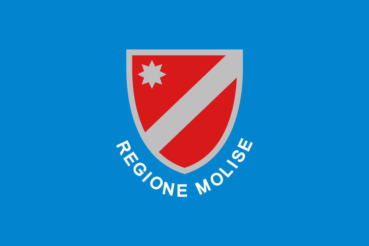 Molise
Montenegro
Molise
Montenegro
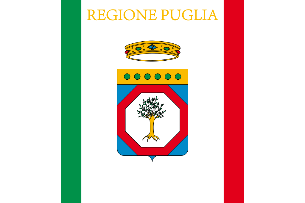 Puglia
Slowenien
Puglia
Slowenien
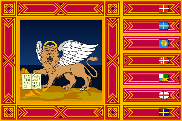 Veneto
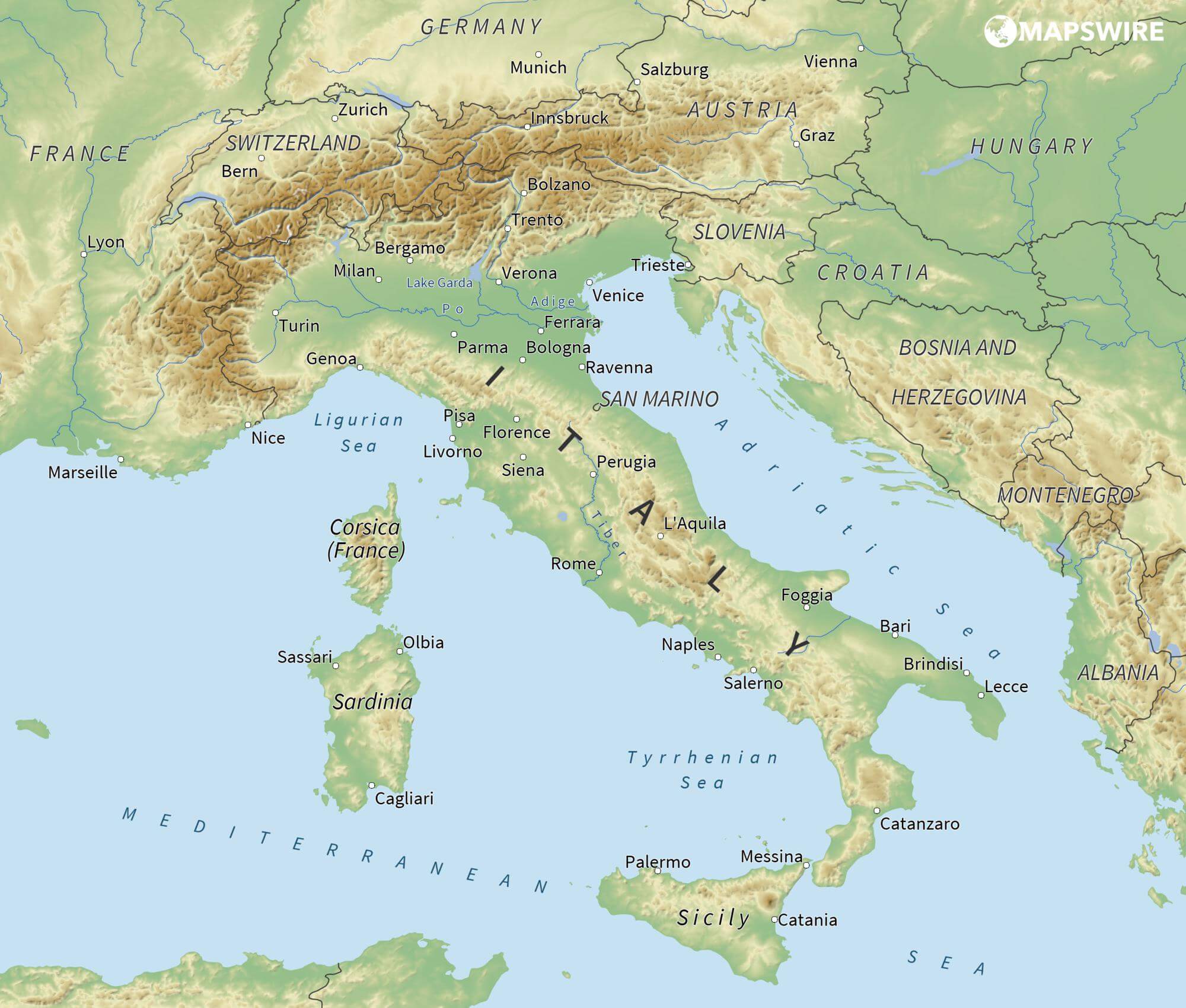
Das Adriatische Meer, kurz auch die Adria (lateinisch Mare Adriaticum; italienisch Mare Adriatico; bosnisch, kroatisch und serbisch Jadransko more oder kurz Jadran; slowenisch Jadransko morje; albanisch Deti Adriatik oder kurz Adriatiku), ist das lang gestreckte nördliche Seitenbecken des Mittelmeeres zwischen der Apenninhalbinsel und Balkanhalbinsel. Es ist nach der Stadt Adria in Italien (Provinz Rovigo) benannt. Zum Adriatischen Meer wird alles gerechnet, was nördlich der Straße von Otranto liegt.
亚得里亚海(意大利语:Mar Adriatico,斯洛文尼亚语:Jadransko morje,克罗地亚语:Jadransko more,阿尔巴尼亚语:Deti Adriatik),是地中海的一部分水域,分隔了意大利半岛(亚平宁半岛)和巴尔干半岛,也分隔了亚平宁山脉与狄那里克阿尔卑斯山脉及其临近地区。亚得里亚海西岸属于意大利,东岸则分别属于斯洛文尼亚、克罗地亚、波斯尼亚和黑塞哥维那、黑山和阿尔巴尼亚。亚得里亚海透过位于其南部的奥特朗托海峡与爱奥尼亚海相连。波河、阿迪杰河、奥凡托河等河流流入亚得里亚海;海中有近1200个岛屿,其中只有69个有人居住。
アドリア海(アドリアかい、英: Adriatic Sea ; イタリア語: Mar Adriatico ; クロアチア語: Jadransko more)は、地中海の海域の一つ。イタリア半島とバルカン半島に挟まれている。
The Adriatic Sea (/ˌeɪdriˈætɪk/) is a body of water separating the Italian Peninsula from the Balkans. The Adriatic is the northernmost arm of the Mediterranean Sea, extending from the Strait of Otranto (where it connects to the Ionian Sea) to the northwest and the Po Valley. The countries with coasts on the Adriatic are Albania, Bosnia and Herzegovina, Croatia, Italy, Montenegro and Slovenia. The Adriatic contains over 1,300 islands, mostly located along the Croatian part of its eastern coast. It is divided into three basins, the northern being the shallowest and the southern being the deepest, with a maximum depth of 1,233 metres (4,045 ft). The Otranto Sill, an underwater ridge, is located at the border between the Adriatic and Ionian Seas. The prevailing currents flow counterclockwise from the Strait of Otranto, along the eastern coast and back to the strait along the western (Italian) coast. Tidal movements in the Adriatic are slight, although larger amplitudes are known to occur occasionally. The Adriatic's salinity is lower than the Mediterranean's because the Adriatic collects a third of the fresh water flowing into the Mediterranean, acting as a dilution basin. The surface water temperatures generally range from 30 °C (86 °F) in summer to 12 °C (54 °F) in winter, significantly moderating the Adriatic Basin's climate.
The Adriatic Sea sits on the Apulian or Adriatic Microplate, which separated from the African Plate in the Mesozoic era. The plate's movement contributed to the formation of the surrounding mountain chains and Apennine tectonic uplift after its collision with the Eurasian plate. In the Late Oligocene, the Apennine Peninsula first formed, separating the Adriatic Basin from the rest of the Mediterranean. All types of sediment are found in the Adriatic, with the bulk of the material transported by the Po and other rivers on the western coast. The western coast is alluvial or terraced, while the eastern coast is highly indented with pronounced karstification. There are dozens of marine protected areas in the Adriatic, designed to protect the sea's karst habitats and biodiversity. The sea is abundant in flora and fauna—more than 7,000 species are identified as native to the Adriatic, many of them endemic, rare and threatened ones.
The Adriatic's shores are populated by more than 3.5 million people; the largest cities are Bari, Venice, Trieste and Split. The earliest settlements on the Adriatic shores were Etruscan, Illyrian, and Greek. By the 2nd century BC, the shores were under Rome's control. In the Middle Ages, the Adriatic shores and the sea itself were controlled, to a varying extent, by a series of states—most notably the Byzantine Empire, the Croatian Kingdom, the Republic of Venice, the Habsburg Monarchy and the Ottoman Empire. The Napoleonic Wars resulted in the First French Empire gaining coastal control and the British effort to counter the French in the area, ultimately securing most of the eastern Adriatic shore and the Po Valley for Austria. Following Italian unification, the Kingdom of Italy started an eastward expansion that lasted until the 20th century. Following World War I and the collapse of Austria-Hungary and the Ottoman Empire, the eastern coast's control passed to Yugoslavia and Albania. The former disintegrated during the 1990s, resulting in four new states on the Adriatic coast. Italy and Yugoslavia agreed on their maritime boundaries by 1975 and this boundary is recognised by Yugoslavia's successor states, but the maritime boundaries between Slovenia, Croatia, Bosnia-Herzegovina, and Montenegro are still disputed. Italy and Albania agreed on their maritime boundary in 1992.
Fisheries and tourism are significant sources of income all along the Adriatic coast. Adriatic Croatia's tourism industry has grown faster economically than the rest of the Adriatic Basin's. Maritime transport is also a significant branch of the area's economy—there are 19 seaports in the Adriatic that each handle more than a million tonnes of cargo per year. The largest Adriatic seaport by annual cargo turnover is the Port of Trieste, while the Port of Split is the largest Adriatic seaport by passengers served per year.
La mer Adriatique (du latin : Mare Hadriaticum ou Mare Adriaticum) est une mer séparant la péninsule italienne de la péninsule balkanique. L'Adriatique est le bras de la Méditerranée situé le plus au nord en s'étendant du canal d'Otrante (où elle rejoint la mer Ionienne) jusqu'aux villes de Venise et de Trieste et à l'embouchure du Pô. Les pays côtiers sont l'Italie, la Slovénie, la Croatie, la Bosnie-Herzégovine, le Monténégro et l'Albanie, ainsi que la Grèce par l'île de Corfou.
Il mare Adriatico è l'articolazione del mar Mediterraneo orientale situata tra la penisola italiana e la penisola balcanica; suddiviso in Alto Adriatico, Medio Adriatico e Basso Adriatico, bagna sei Paesi: Italia, Slovenia, Croazia, Bosnia ed Erzegovina, Montenegro e Albania, confinando a sud-est con il Mar Ionio.
El mar Adriático (del latín, Mare Hadriaticum) es un golfo estrecho y alargado que forma parte del mar Mediterráneo. Se encuentra situado entre la península Itálica, al oeste, y la península de los Balcanes, al este, con una anchura máxima de unos 200 km, y una longitud de unos 800 km. Su extremo meridional limita con el mar Jónico, del que lo separa el canal de Otranto. Su superficie total es de, aproximadamente, 160 000 km².
Las costas occidental, septentrional, y parte de la oriental corresponden a Italia (60% de la longitud de costa del Adriático), mientras que el resto de la costa oriental corresponde a Croacia, Eslovenia, Bosnia y Herzegovina, Montenegro y Albania. Algunos de los ríos que desembocan en el Adriático son el Reno, el Po, el Adigio, el Brenta, el Piave y el Neretva.
La costa del Adriático concentra un gran número de centros turísticos, como Venecia, que recibe el nombre de «Reina del Adriático». Tras la división de Yugoslavia, la costa croata se ha convertido también en un destino turístico muy popular.
Sus aguas sostienen industria pesquera, y se llevan a cabo prospecciones petrolíferas en este mar. Durante los años 1990, varias investigaciones revelaron que sus niveles de contaminación son muy altos.
En las últimas décadas el gobierno de Italia ha intentado hacer de él una barrera contra la inmigración ilegal, en su mayor parte proveniente de Albania.
Адриати́ческое мо́ре (итал. mare Adriatico, эмил.-ром. Mèr Adriâtic, вен. Mar Adriàtico, неап. Mar Adriateco, словен. Jadransko morje, сербохорв. Jadransko more/Јадранско море, алб. Deti Adriatik, лат. mare Hadriaticum), также Адриатика — полузамкнутое море, часть Средиземного моря между Апеннинским и Балканским полуостровами. Омывает берега Италии (более 1000 км), Словении (47 км), Хорватии (1777 км), Боснии и Герцеговины (20 км), Черногории (200 км), Албании (472 км).

Istrien (kroatisch/slowenisch Istra, italienisch Istria, istriotisch Eîstria) ist mit einer Fläche von etwa 3500 km² die größte Halbinsel an der nördlichen Adria. Sie erstreckt sich zwischen dem Golf von Triest und der Kvarner-Bucht vor Rijeka, im Osten reicht sie bis zur rund 1400 m hohen Učka. An der Halbinsel haben drei Staaten Anteil. Der größte Flächenanteil befindet sich auf dem Gebiet Kroatiens, ein kleinerer im Norden gehört zu Slowenien, zu Italien gehört nur das Gebiet um Muggia und dessen Umland.
伊斯特拉半岛(克罗地亚语、斯洛文尼亚语:Istra),又称伊斯特里亚,(意大利语、威尼托语:Istria),是欧洲亚德里亚海东北岸的一个三角形半岛。西临威尼斯湾。
 Europäische Union
Belgien
Bulgarien
Dänemark
Deutschland
Estland
Finnland
Frankreich
Griechenland
Irland
Island
Israel
Italien
Kroatien
Lettland
Litauen
Luxemburg
Malta
Monaco
Montenegro
Niederlande
Nordmazedonien
Norwegen
Österreich
Polen
Portugal
Rumänien
Russland
San Marino
Schweden
Schweiz
Serbien
Slowakei
Slowenien
Spanien
Tschechien
Türkei
Ukraine
Ungarn
Vereinigtes Königreich
Europäische Union
Belgien
Bulgarien
Dänemark
Deutschland
Estland
Finnland
Frankreich
Griechenland
Irland
Island
Israel
Italien
Kroatien
Lettland
Litauen
Luxemburg
Malta
Monaco
Montenegro
Niederlande
Nordmazedonien
Norwegen
Österreich
Polen
Portugal
Rumänien
Russland
San Marino
Schweden
Schweiz
Serbien
Slowakei
Slowenien
Spanien
Tschechien
Türkei
Ukraine
Ungarn
Vereinigtes Königreich
 Wissenschaft und Technik
Zypern
Albanien
Bosnien-Herzegowina
Bulgarien
Estland
Kosovo
Kroatien
Lettland
Litauen
Montenegro
Nordmazedonien
Polen
Rumänien
Serbien
Slowakei
Slowenien
Tschechien
Ungarn
Wissenschaft und Technik
Zypern
Albanien
Bosnien-Herzegowina
Bulgarien
Estland
Kosovo
Kroatien
Lettland
Litauen
Montenegro
Nordmazedonien
Polen
Rumänien
Serbien
Slowakei
Slowenien
Tschechien
Ungarn
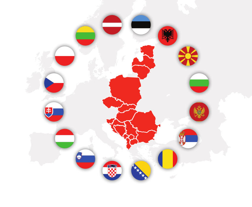
Mittel- und osteuropäische Länder (MOEL), auch Mittel-/Osteuropa (MOE), steht für den gleichbedeutenden Begriff mittel- und osteuropäische Staaten (MOES). Der englische Ausdruck lautet CEE für englisch Central and Eastern Europe, der französische PECO für französisch Pays d’Europe centrale et orientale. Weitgehend identisch ist der EU-statistische Begriff Central and Eastern European Countries (CEC oder CEEC).
Welche Länder tatsächlich zu den mittel- und osteuropäischen Ländern gehören, ist unscharf abgegrenzt. Im engeren Sinn wird der Begriff für jene Länder gebraucht, die im Rahmen der EU-Erweiterung 2004 und 2007 in die Europäische Union aufgenommen wurden (EU-12), bzw. für jene Staaten des Westbalkans, die sich im Erweiterungsprozess befinden. Die ebenfalls unscharf abgegrenzte Großregion Ostmitteleuropa ist ein Teil der MOEL.
中东欧是一个欧洲大陆的地缘政治概念,包括冷战后影响力最大、统一后的德国,受德国影响及冷战时作为中立国的奥地利,冷战时期被苏联所控制的东欧卫星国,波罗的海三国(立陶宛、拉脱维亚、爱沙尼亚),再加上摩尔多瓦、白罗斯、乌克兰和俄罗斯。
为了避免意识形态和政治上的怀疑,同时为了弥补政治地理与自然地理的差距,中东欧是近年来兴起的一种称呼,特别是在冷战之后,大部分中东欧国家皆加入欧盟及北约,成为西方自由世界的一部分,中东欧的社会政治及经济发展日益受到西方自由阵营原有国家的关注。
欧盟统计局目前使用 CEC 或 CEEC(中欧和东欧国家)这一术语来指中欧和东欧地区寻求加入欧盟的下列国家:
阿尔巴尼亚
波斯尼亚和黑塞哥维那
科索沃
北马其顿
黑山共和国
塞尔维亚
土耳其
在 2004 年 5 月 1 日加入欧洲联盟之前,下列国家也属于这一类别:
爱沙尼亚
拉脱维亚
立陶宛
波兰
匈牙利
捷克共和国
斯洛伐克
斯洛文尼亚
在 2007 年 1 月 1 日加入欧盟之前,以下国家也属于这一类别:
罗马尼亚
保加利亚
在 2013 年 7 月 1 日加入欧盟之前,以下国家也属于此类国家:克罗地亚
克罗地亚
中東欧(ちゅうとうおう)は、ヨーロッパの区分で、様々に解釈されるが、主に二つの意味がある。
- 中欧(中央ヨーロッパ)と東欧(東ヨーロッパ)を合わせた地域。(この場合中・東欧とも書く。他のヨーロッパの区分と違い、「中東とヨーロッパ」と取られる可能性もあるため、中東ヨーロッパとはほとんど言わない)。
- 中欧のうち過去に東側諸国に組み込まれていた地域で、かつ2004年以降に欧州連合(EU)に加盟した諸国のみを指す。
日本では1.の意味で用いられることが多く、英語圏などではでは中東欧を一般に「CEE」と表記し、2.の意味で用いることも多い。
Central and Eastern Europe, abbreviated CEE, is a term encompassing the countries in Central Europe (the Visegrád Group), the Baltics, Eastern Europe, and Southeastern Europe (Balkans), usually meaning former communist states from the Eastern Bloc (Warsaw Pact) in Europe. Scholarly literature often uses the abbreviations CEE or CEEC for this term.[1][2][3] The Organisation for Economic Co-operation and Development also uses the term "Central and Eastern European Countries (CEECs)" for a group comprising some of these countries.
Depuis les années 1990, la plupart des pays européens dont la majeure partie du territoire s'étend à l'est du 15e degré de longitude Est sont parfois collectivement désignés sous l'appellation de pays de l'Europe centrale et orientale (PECO). Toutefois, la Suède, la Finlande, la Grèce et Chypre ne sont pas considérés dans cet ensemble malgré leur situation géographique, cette notion étant généralement réservée aux anciens pays du bloc de l'Est et aux États européens issus de la dislocation de l'URSS comme les pays baltes, ainsi que de la Tchécoslovaquie et de la Yougoslavie.
Europa centro-orientale è la designazione, usata soprattutto in ambito accademico, della regione d'Europa comprendente la parte orientale dell'Europa centrale. Ne fanno parte le seguenti nazioni che si estendono ad est della Germania e sono comprese fra il Mar Baltico al nord e la Grecia a sud[1]:
Центральная и Восточная Европа (ЦВЕ) (англ. Central and Eastern Europe, CEE) — бывшие социалистические государства Восточной Европы, не входящие в СНГ.
В литературе встречаются название — Восточно-Центральная Европа (ВЦЕ).