
漢德百科全書 | 汉德百科全书
 Northern Ireland

 Architecture

 Geography

Die Insel Irland ist etwa 450 km lang und rund 260 km breit und liegt im Atlantik. Insgesamt hat sie eine Fläche von etwa 84.421 km². Sie ist damit die drittgrößte Insel Europas und die zwanzigstgrößte der Welt. An der Küste gelegene Berge umgeben zentrale Ebenen. Der Carrauntuohill im County Kerry ist mit 1041 Metern der höchste Berg. Der Shannon teilt die Insel in zwei nicht gleich große Teile und ist mit rund 370 km, von denen knapp 250 km schiffbar sind, der längste Fluss.
爱尔兰岛(英语:Ireland,爱尔兰语:Éire)是位于欧洲西北部的大西洋岛屿,以面积计算是欧洲第三大岛。岛上大部分区域属于爱尔兰共和国的领土,至于岛上东北部的北爱尔兰地区之主权则属于英国。
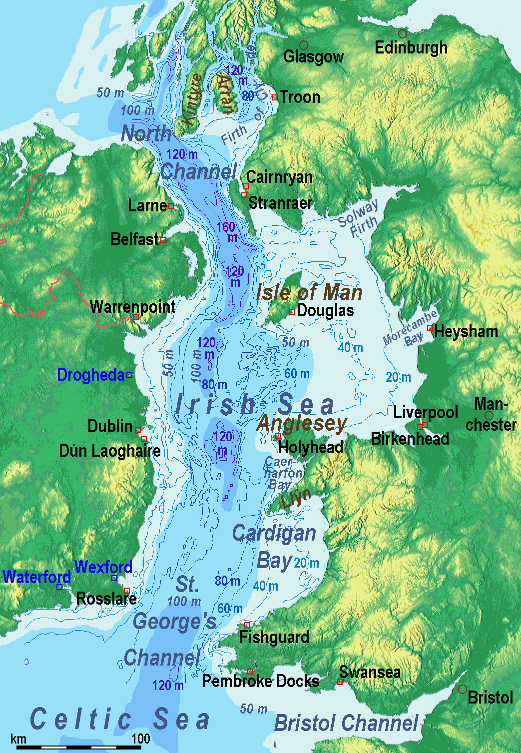
爱尔兰海(英语:Irish Sea、爱尔兰语:Muir Éireann)位于英国不列颠岛和爱尔兰岛之间;它南端的圣乔治海峡处于爱尔兰和威尔士之间,北端的北海海峡处于爱尔兰和苏格兰之间,两者都与大西洋相通。
爱尔兰海面积10万平方公里,平均水深61米,西北部最深处达272米。
不列颠岛和爱尔兰岛之间经爱尔兰海的交通连接包括由斯旺西(Swansea)至科克(Cork)、费什加德(Fishguard)及彭布洛克(Pembroke)至罗斯莱尔(Rosslare)、荷利赫德(Holyhead)至当莱瑞(Dún Laoghaire)、斯特兰拉尔(Stranraer)至贝尔法斯特及拉恩(Larne)、和凯安雷恩(Cairnryan)至拉恩的路线。另外还有利物浦经马恩岛往贝尔法斯特的路线。

 UEFA European Championship 2016
UEFA European Championship 2020
UEFA European Championship 2016
UEFA European Championship 2020
 Group C
Northern Ireland
Group C
Northern Ireland
 Sport
(F)UEFA Nations League
UEFA Nations League
UEFA Nations League B - Group 3
United Kingdom
Sport
(F)UEFA Nations League
UEFA Nations League
UEFA Nations League B - Group 3
United Kingdom


 Colleges and Universities in Europe
Nobel prize
Nobel Prize in Literature
Nobel prize
Nobel Peace Prize
Nobel prize
University/Institute
Russell Group
Universities in the UK
United Kingdom
Colleges and Universities in Europe
Nobel prize
Nobel Prize in Literature
Nobel prize
Nobel Peace Prize
Nobel prize
University/Institute
Russell Group
Universities in the UK
United Kingdom

 International cities

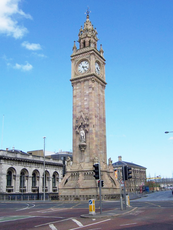
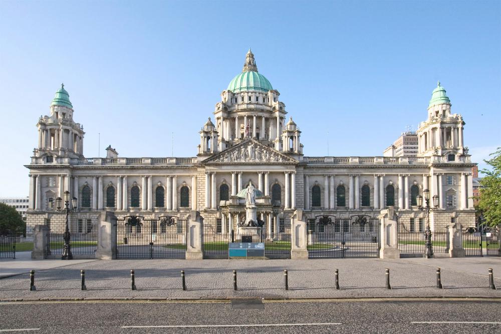
Belfast [bɛɫˈfɑːst] (irisch Béal Feirste [ˌbʲeːɫ ˈfʲɛɾʲʃtʲə]) ist die Hauptstadt von Nordirland im Vereinigten Königreich Großbritannien und Nordirland und die zweitgrößte Stadt der irischen Insel nach Dublin.
Belfast hat etwa 343.000 Einwohner (2019) und liegt an der Mündung des Flusses Lagan in der Bucht von Belfast (englisch Belfast Lough). Die Stadt besitzt den Status einer City und bildet einen der elf nordirischen Verwaltungsbezirke. Im Dublin-Belfast corridor entlang der Autobahn wohnen drei der sechs Millionen Iren.
Belfast ist Sitz eines katholischen (Bistum Down und Connor) und eines anglikanischen Bischofs (Bistum Down und Dromore), Universitätsstadt und besitzt einen Seehafen. Die Stadt ist außerdem Sitz der Regierung und des Parlaments von Nordirland. Innerstädtische Gebiete Belfasts gehörten vor allem in den 1970er Jahren zu den Schauplätzen des Nordirlandkonflikts.
贝尔法斯特(英语:Belfast /ˈbɛlfɑːst, -fæst/;爱尔兰语:Béal Feirste),中文简称贝法,位于爱尔兰岛东北沿海的拉干河口,在贝尔法斯特湾的西南侧,是英国北爱尔兰的最大城市及最大港口,也是爱尔兰岛的第二大城市,仅次于都柏林。始建于1888年,自1922年起成为北爱尔兰的首府。现有人口276,459,都会区579,554,是北爱尔兰政治、文化中心和最大的工业城市。
19世纪初贝尔法斯特成为了一个大港口,而贝尔法斯特也成为了世界最大的麻布产地,号称“Linenopolis”,此外造船业(制造泰坦尼克号的哈兰德与沃尔夫造船厂位于此地)和香烟制造业也较为发达。1888年获得城市地位。后来又发展起了宇航工业,是二战后世界主要工业城市之一。
1970—80年代由于北爱尔兰问题,该城市治安变差,成为世界上最不安全的城市之一[1]。但到了21世纪它已经摆脱了这些问题的困扰,经济稳定增长。他现在不但是一座港市,也因有乔治·贝斯特贝尔法斯特城市机场和贝尔法斯特国际机场而成为北爱尔兰的交通枢纽。