Deutsch-Chinesische Enzyklopädie, 德汉百科
 Silk road

Alexandria oder Alexandrien (altgriechisch Ἀλεξάνδρεια Alexándreia, nach Alexander dem Großen; arabisch الإسكندرية al-Iskandariyya; koptisch: Ⲣⲁⲕⲟϯ Rakoti bzw. ⲁⲗⲉⲝⲁⲛⲇⲣⲓⲁ Aleksandria) ist mit über fünf Millionen Einwohnern (Stand 2023) und einer Ausdehnung von 32 Kilometern entlang der Mittelmeerküste nach Kairo die zweitgrößte Stadt Ägyptens und die insgesamt größte ägyptische Stadt mit direktem Zugang zum Mittelmeer. Sie besitzt den größten Seehafen des Landes, an dem etwa 80 % des ägyptischen Außenhandels abgewickelt werden. Als bedeutender Industriestandort wird sie über Pipelines mit Erdöl und Erdgas aus Suez versorgt.
Alexandria wurde 331 v. Chr. vom Makedonen Alexander dem Großen an der Stelle der altägyptischen Siedlung Rhakotis gegründet und unter Ptolemaios II. zwischen 285 und 247 v. Chr. fertiggestellt. Die Stadt, Residenz der Ptolemäer, entwickelte sich rasch zu einem der wichtigsten Zentren der hellenistischen Welt sowie später des römischen und frühbyzantinischen Ägypten. Sie war nach dem Ende der Ptolemäer Hauptstadt der römischen Provinz Aegyptus, in der Spätantike dann der Dioecesis Aegypti. Das antike Alexandria war vor allem für seinen Leuchtturm (Pharos), eines der sieben Weltwunder der Antike, und für seine Große Bibliothek bekannt.
Nach der Islamischen Eroberung Ägyptens 641 n. Chr. und mit der Gründung von Kairo verlor die Stadt ihre Bedeutung. Anfang des 19. Jahrhunderts zu einem vom Hinterland abgeschnittenen Fischerdorf herabgesunken, gelang Alexandria dank dem Bau des Mahmudiyakanals und dem Aufblühen des lukrativen ägyptischen Baumwollhandels der Wieder-Aufstieg zu einem wichtigen internationalen Handelszentrum.
Im Hafen von Alexandria finden seit 1994 unterwasserarchäologische Untersuchungen statt, durch die neue Erkenntnisse zur Vorgängersiedlung Rhakotis und zur ptolemäischen Epoche gewonnen werden konnten.
亚历山大[1][2](阿拉伯语:الإسكندرية,罗马化:al-Iskandarīyah,发音:[al.ʔiskanˈdarijja];埃及阿拉伯语:اسكندرية,罗马化:Eskenderiyya,发音:[eskendeˈɾejjæ];希腊语:Ἀλεξάνδρεια,罗马化:Alexándreia;英语:Alexandria),又译亚历山太和亚历山大里亚,汉时称为乌迟散[3], 埃及第二大城市、亚历山大省省会,也是地中海沿岸最大城市,阿拉伯世界第四大城市及非洲第九大城市。其地理位置为北纬31°12',东经29°15',离开罗西北208千米。尼罗河多支的、现已干枯的入海口位于亚历山大东19千米处,古城克诺珀斯的遗迹就在那里。今天亚历山大有约334万居民。
亚历山大是按其奠基人亚历山大大帝命名的,它是托勒密王朝的首都,很快就成为古希腊文化中最大的城市。在西方古代史中其规模和财富仅次于罗马。虽然埃及的伊斯兰教统治者在奠定了开罗为埃及的新首都后亚历山大的地位不断下降。但在十九世纪末期,亚历山大跃升为世界主要的船运及交易中心之一,蓬勃的棉花业与连接红海和地中海地区的优越地理位置带给这个城市丰厚的利润。
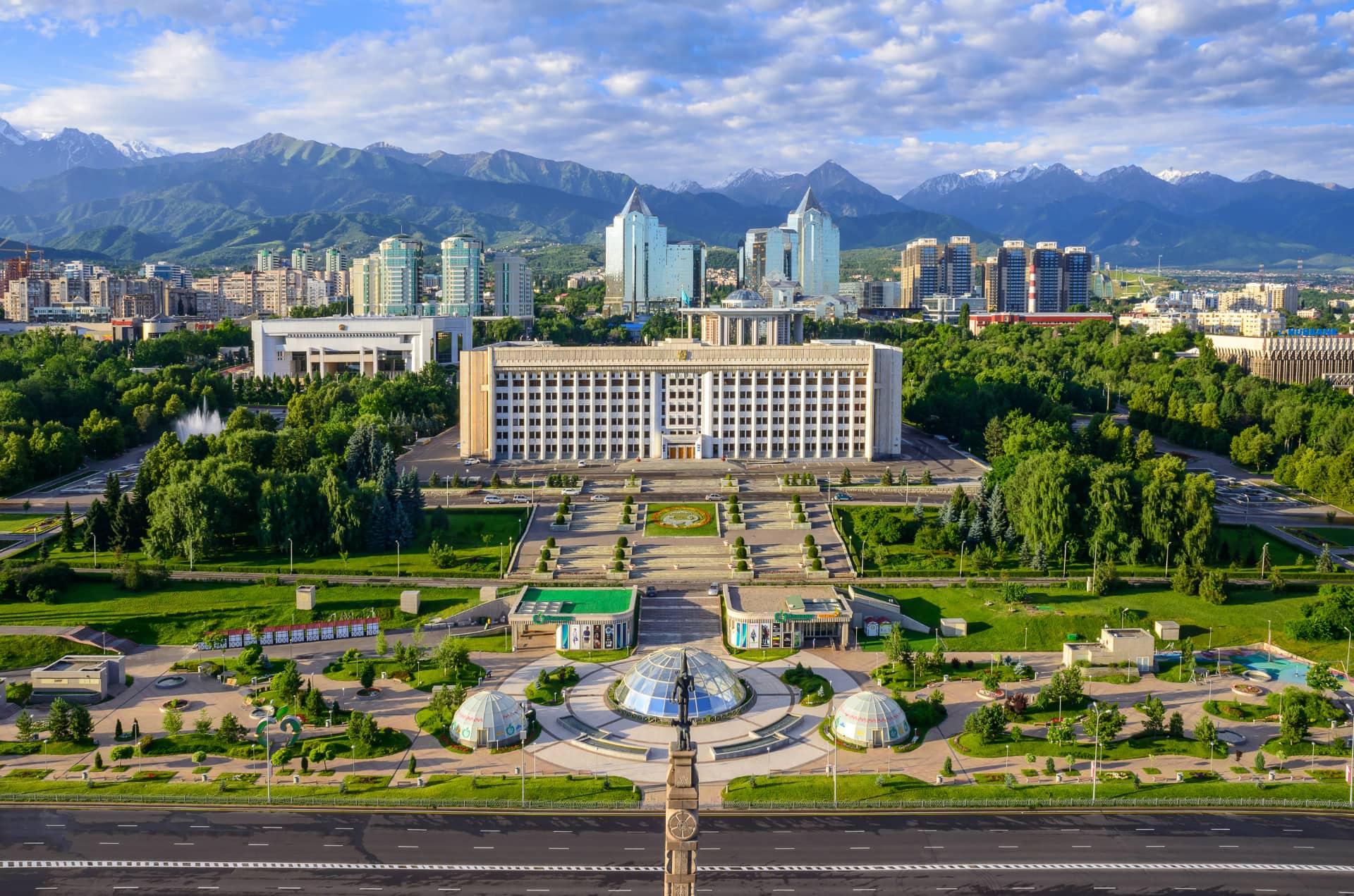
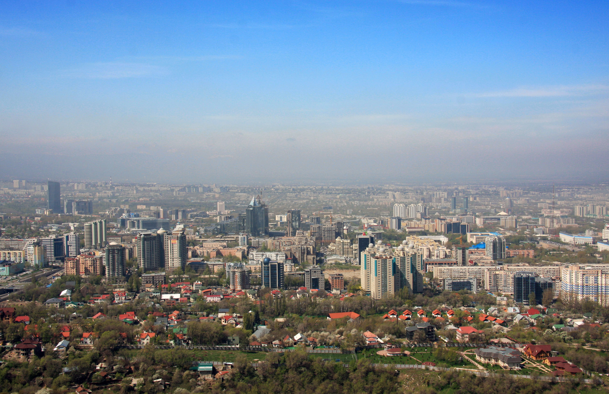
Almaty (kasachisch und russisch Алматы, bis 1993 Alma-Ata) ist mit rund zwei Millionen Einwohnern die größte Stadt Kasachstans. Sie liegt im Südosten des zentralasiatischen Staates unweit der Grenze zu Kirgisistan, war von 1936 bis 1991 Hauptstadt der Kasachischen SSR und nach dem Zerfall der Sowjetunion bis 1997 von Kasachstan.
Almaty ist neben der Hauptstadt Astana noch immer das kulturelle, wissenschaftliche und wirtschaftliche Zentrum des Landes mit Universitäten und zahlreichen Sakralbauten, Museen und Theatern. Zu den bekanntesten Sakralbauten gehören die Christi-Himmelfahrt- und die Nikolaus-Kathedrale. Der 1983 fertiggestellte 371,5 Meter hohe Fernsehturm Almaty auf dem Berg Kök-Töbe gehört zu den höchsten Bauwerken der Welt. Seit Anfang des 21. Jahrhunderts sind auch einige Wolkenkratzer in der Stadt entstanden. Die Stadt verfügt über zwei Bahnhöfe und zwei Flughäfen. Die am 1. Dezember 2011 eröffnete Metro Almaty sowie Oberleitungsbusse sorgen für den innerstädtischen Personentransport.
阿拉木图(哈萨克语:Алматы/Almaty,读作 [ɑlmɑˈtə] (ⓘ);俄语:Алма-Ата)是哈萨克斯坦的一座直辖市,是该国的第一大城市。坐落在哈萨克斯坦东南部的山区,邻近吉尔吉斯斯坦。阿拉木图早年盛产苹果,因此有“苹果城”之称。
阿拉木图(哈萨克语和俄语 Алматы,1993 年以前为阿拉木图)是哈萨克斯坦最大的城市,约有 200 万居民。它位于中亚国家的东南部,离吉尔吉斯斯坦边境不远。除首都阿斯塔纳外,阿拉木图仍是该国的文化、科学和经济中心,拥有多所大学和众多宗教建筑、博物馆和剧院。最著名的宗教建筑包括耶稣升天大教堂和圣尼古拉大教堂。
 Architecture
 Civilization

Die Altstadt von Damaskus gehört zum UNESCO-Welterbe in Syrien.
Wegen der günstigen Lage an der Kreuzung wichtiger Handelswege ist die Altstadt von Damaskus einer der ältesten kontinuierlich bewohnten Orte weltweit. Die Umayyaden machten Damaskus zur Hauptstadt ihres Kalifats. Außer den mittelalterlichen Bauten, die von dieser Blütezeit zeugen, sind im Stadtbild auch Elemente hellenistischer, römischer und byzantinischer Architektur erkennbar. Insgesamt präsentiert sich die historische Altstadt dem Besucher heute in der Form, die sie seit der ottomanischen Eroberung am Anfang des 16. Jahrhunderts erhielt. Wie alle syrischen Welterbestätten steht auch die Altstadt von Damaskus seit 2013 auf der Roten Liste des gefährdeten Welterbes.

Astana [astaˈna],[2] deutsch auch [asˈtaːna][3] (kasachisch und russisch Астана; Астана ist auch das kasachische Wort für Hauptstadt) ist seit dem 10. Dezember 1997 die Hauptstadt Kasachstans. Sie befindet sich im nördlichen Teil des Landes inmitten der Kasachischen Steppe am Ufer des Flusses Ischim. Mit 1.354.435 Einwohnern (Stand 1. Januar 2023) ist sie nach Almaty die zweitgrößte Stadt des Landes.
Die Stadt wurde 1830 als russische Festung gegründet. In den 1950er Jahren wurde der Ort zum Zentrum der sowjetischen Neulandkampagne zur Gewinnung von landwirtschaftlichen Anbauflächen. Dies führte dazu, dass sich das Stadtbild veränderte und die Entwicklung der Stadt vorangetrieben wurde. Nach der Unabhängigkeit Kasachstans von der Sowjetunion wurde eine Verlegung der Hauptstadt beschlossen und die Stadt somit am 10. Dezember 1997 zur Planhauptstadt. Im Süden der Stadt entstand daraufhin ein modernes Regierungsviertel mit markanten Bauwerken wie dem Bajterek-Turm, dem Khan Shatyr oder der Pyramide des Friedens und der Eintracht.
阿斯塔纳[3](哈萨克语:Астана/Astana,读作 [ɑstɑnɑ] (ⓘ))位于哈萨克斯坦中北部,是该国的首都、直辖市和第二大城市,四周与阿克莫拉州接壤。伊希姆河穿城而过,生态环境良好,是哈萨克斯坦工农业的主要生产基地、全国铁路交通枢纽。
现代的阿斯塔纳是一个新市镇,并遵循其他规划首都的进程进行城市规划。[4]自从成为哈萨克斯坦首都后,这座城市的面貌发生了巨大的变化。阿斯塔纳的总体规划是由日本建筑师黑川纪章设计的,并作为哈萨克斯坦政府、议会大厦、最高法院、阿克奥尔达总统府和众多政府部门和机构的所在地。目前城市也兴建一系列未来主义建筑,包括许多摩天大楼。
Eurovision Song Contest,ESC
 History
Greece
History
Greece
 International cities
 *European Capital of Culture
Olympic Summer Games
Silk road
*European Capital of Culture
Olympic Summer Games
Silk road
 World Heritage
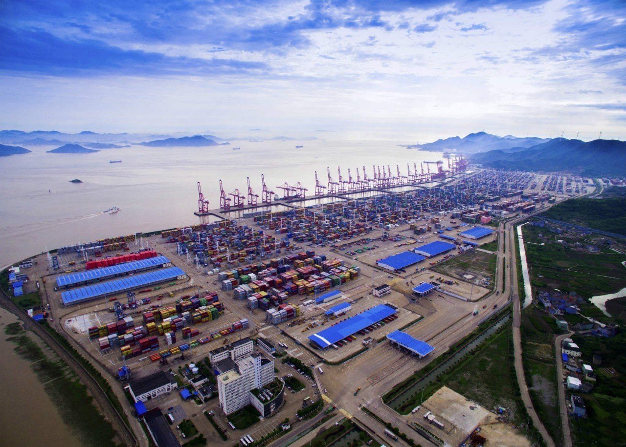
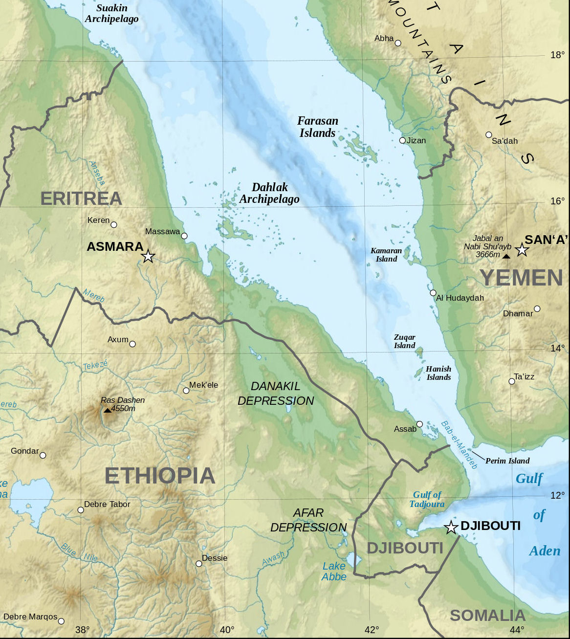
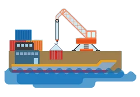 Important port
雅典建城至今已经有5000多年的历史,公元前8世纪,爱奥尼亚人建成的雅典是古希腊城邦的盟主。古代雅典是西方文化的源泉,雅典人对艺术、哲学、法律、科学作出了杰出的贡献。公元前5世纪为雅典的鼎盛时期,出现了许多不朽的大师。大悲剧家欧里庇德斯、大喜剧家阿里斯托芬、哲学家苏格拉底、柏拉图、亚里斯多德、历史学家希罗多德等都在这里诞生或居住过,这些光辉的名字照耀着人类文化的黎明。
雅典是希腊的古文物中心,至今仍保存着很多古代文化遗址,如今仍能显出当年的雄伟气概。雅典的博物馆世界驰名。
跨越时空两千五百年正是雅典给人的感觉,山丘上的卫城是西元前五百年的伟大艺术杰作,而山下的波拉卡区千年来就是一本希腊人的生活宝库,而身为希腊的首都及最大的城市,雅典的现代化建筑,拥挤的交通和空气污染严重,又和世界一般大都会无异。
现在雅典是全世界旅游爱好者的度假胜地。蔚蓝的爱琴海边涛声依旧,雅典的一砖一砾都闪烁着人类文明的光辉。 (Quelle:http://eur.bytravel.cn)
雅典(希腊语:Αθήνα,Athína,[aˈθina];古希腊语:Άθῆναι,转写:Athēnai)是希腊首都,也是希腊最大的城市。雅典位于巴尔干半岛南端,三面环山,一面傍海,西南距爱琴海法利龙湾8公里,属亚热带地中海气候。基菲索斯河和伊利索斯河穿城而过。市内多小山。
雅典是世界上最老的城市之一,有记载的历史就长达3000多年。现在雅典是欧洲第八大城市[1]。雅典是希腊经济、财政、工业、政治和文化中心。雅典也是欧盟商业中心之一。市区人口330万,加上郊区人口共有380万人口。城市的面积为39平方公里,加上郊区为412平方公里。[2]
古雅典是一个强大的城邦,是驰名世界的文化古城。希腊是西方哲学的摇篮,是柏拉图学院和亚里士多德的讲学场所的所在地。[3][4]苏格拉底、希罗多德、伯里克利、索福克勒斯、阿里斯托芬、欧里庇得斯、埃斯库罗斯和其他著名的哲学家、政治家和文学家都在雅典诞生或居住过[5],雅典也因此被称作“西方文明的摇篮”和民主的起源地。[6]公元前5世纪和4世纪在文化和政治上的成就对欧洲及世界文化产生重大影响。[7]
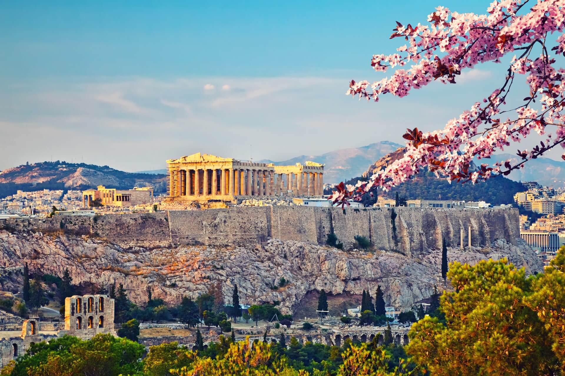
雅典至今仍保留了很多历史遗迹和大量的艺术作品,其中最著名的是雅典卫城的帕提农神庙,是西方文化的象征。
雅典是现代奥运会起源的地方。1896年曾举办过第一届夏季奥运会。2004年,第二十八届夏季奥林匹克运动会在雅典举行。Athen – neugriechisch Αθήνα [aˈθina] (f. sg.), Katharevousa und altgriechisch Ἀθῆναι Athênai (f. pl.) – ist die Hauptstadt Griechenlands. Athen ist die bevölkerungsreichste und flächengrößte Stadt des Landes. Die Gemeinde Athen im Zentrum des Ballungsraums Athen-Piräus ist dabei relativ klein. Athen im weiteren Sinne umfasst das Gebiet der Regionalbezirke Athen-Zentrum (87,3 km²), Athen-Nord (138,79 km²), Athen-Süd (68,9 km²), Athen-West (66,8 km²) und einiger umliegender Vororte mit zusammen 3,753 Mio. Einwohnern.[2]
Als kulturelles, historisches und wirtschaftliches Zentrum des Landes ist Athen auch die bedeutendste Metropole Griechenlands. Der Flughafen ist der wichtigste des Landes und der acht Kilometer vom Athener Zentrum entfernte Hafen Piräus der größte Griechenlands. Von hier und vom kleineren Rafina wird auch der Schiffsverkehr zu den zahlreichen griechischen Inseln abgefertigt. Im Schienenverkehr hat Athen nationale, jedoch keine internationale Bedeutung.
Die Stadt ist seit der Jungsteinzeit kontinuierlich besiedelt[3] und damit eine der ältesten Siedlungen und Städte Europas. 1985 wurde Athen erste Kulturhauptstadt Europas. In die Liste des Weltkulturerbes der UNESCO wurde 1987 die Akropolis und 1990 das Kloster Daphni aufgenommen.
Athen war in der klassischen Zeit Ort der attischen Polis. Die in dieser Zeit (5. Jahrhundert v. Chr.) entstandene attische Demokratie gilt als Begründerin einer auf dem Prinzip der Volkssouveränität gegründeten politischen Ordnung.
アテネ(現代ギリシア語: Αθήνα; Athína; IPA: [aˈθina]; カサレヴサ: Ἀθῆναι, Athinai; 古代ギリシア語: Ἀθῆναι, Athēnai)は、ギリシャ共和国の首都で同国最大の都市である。
アテネはアッティカ地方にあり、世界でももっとも古い都市の一つで約3,400年の歴史がある。古代のアテネであるアテナイは強力な都市国家であったことで知られる。芸術や学問、哲学の中心で、プラトンが創建したアカデメイアやアリストテレスのリュケイオン[1][2]があり、西洋文明の揺籃や民主主義の発祥地として広く言及されており[3][4]、その大部分は紀元前4-5世紀の文化的、政治的な功績により後の世紀にヨーロッパに大きな影響を与えたことは知られている。[5]今日の現代的なアテネは世界都市としてギリシャの経済、金融、産業、政治、文化生活の中心である。2008年にアテネは世界で32番目に富める都市に位置し[6]、UBSの調査では25番目に物価が高い都市[7]に位置している。
アテネ市の人口は655,780人[8](2004年は796,442人)[9]、市域面積は39 km2 (15 sq mi)[10]である。アテネの都市的地域(大アテネや大ピラエウス)は市域を超えて広がっており、人口は2011年現在3,074,160人に達し[11]、都市的地域の面積は412 km2 (159 sq mi)[10]である。ユーロスタットによれば大都市圏地域(Larger Urban Zones,LUZ) (en) の人口は欧州連合域内では7番目に大きい。
古典ギリシアの文化的遺産は今でもはっきりとしており、多くの古代遺跡や芸術作品が象徴している。もっとも有名で代表的なものにはパルテノン神殿があり初期の西洋文明の鍵となるランドマークと見なされる場合もある。アテネにはローマ帝国支配下のギリシャやビザンティンの遺跡もあり同様に少数のオスマン帝国の遺跡も残されているなど、何世紀にもわたる長い歴史を投影するモニュメントとなっている。アテネには2つのユネスコの世界遺産がありアテナイのアクロポリスと中世のダフニ修道院がそうである。現代のランドマークはギリシアが1833年に独立国となりアテネが首都に制定された時のもので、ギリシャ議会の議事堂や3部作(Trilogy )で構成されたギリシア国立図書館、アテネ大学、アテネアカデミーが含まれる。アテネは、最初の近代オリンピックであるアテネオリンピックと、その108年後に開催されたアテネオリンピック (2004年)の2度のオリンピックの舞台である。[12]アテネにはアテネ国立考古学博物館があり、世界最大の古代ギリシアの遺品の収蔵を特徴とし新しい2008年に完成したアクロポリス博物館もある。ギリシャ正教会の首長であるアテネ大主教が所在し、精神的な中心地でもある。(ギリシャ正教会は正教会に属し、クレタ島を除くギリシャ一国を管轄する。)正教会の定めるアテネの守護聖人は、ディオニシオス・オ・アレオパギティス、イェロテオス、フィロセイ。1985年には欧州文化首都に選ばれた。
Athens (/ˈæθɪnz/;[3] Greek: Αθήνα, Athína [aˈθina]; Ancient Greek: Ἀθῆναι, Athênai [a.tʰɛ̂ː.nai̯]) is the capital and largest city of Greece. Athens dominates the Attica region and is one of the world's oldest cities, with its recorded history spanning over 3,400 years[4] and its earliest human presence starting somewhere between the 11th and 7th millennium BC.[5]
Classical Athens was a powerful city-state that emerged in conjunction with the seagoing development of the port of Piraeus, which had been a distinct city prior to its 5th century BC incorporation with Athens. A centre for the arts, learning and philosophy, home of Plato's Academy and Aristotle's Lyceum,[6][7] it is widely referred to as the cradle of Western civilization and the birthplace of democracy,[8][9] largely because of its cultural and political impact on the European continent, and in particular the Romans.[10] In modern times, Athens is a large cosmopolitan metropolis and central to economic, financial, industrial, maritime, political and cultural life in Greece. In 2012, Athens was ranked the world's 39th richest city by purchasing power[11] and the 67th most expensive[12] in a UBS study.
Athens is a global city and one of the biggest economic centres in southeastern Europe. It has a large financial sector, and its port Piraeus is both the largest passenger port in Europe,[13][14][15][16] and the second largest in the world.[17][dead link] The Municipality of Athens (also City of Athens) had a population of 664,046 (in 2011)[2] within its administrative limits, and a land area of 38.96 km2 (15.04 sq mi).[18][19] The urban area of Athens (Greater Athens and Greater Piraeus) extends beyond its administrative municipal city limits, with a population of 3,090,508 (in 2011)[20] over an area of 412 km2 (159 sq mi).[19] According to Eurostat[21] in 2011, the functional urban area (FUA) of Athens was the 9th most populous FUA in the European Union (the 6th most populous capital city of the EU), with a population of 3.8 million people. Athens is also the southernmost capital on the European mainland.
The heritage of the classical era is still evident in the city, represented by ancient monuments and works of art, the most famous of all being the Parthenon, considered a key landmark of early Western civilization. The city also retains Roman and Byzantine monuments, as well as a smaller number of Ottoman monuments. Athens is home to two UNESCO World Heritage Sites, the Acropolis of Athens and the medieval Daphni Monastery. Landmarks of the modern era, dating back to the establishment of Athens as the capital of the independent Greek state in 1834, include the Hellenic Parliament and the so-called "architectural trilogy of Athens", consisting of the National Library of Greece, the National and Kapodistrian University of Athens and the Academy of Athens. Athens is also home to several museums and cultural institutions, such as the National Archeological Museum, featuring the world's largest collection of ancient Greek antiquities, the Acropolis Museum, the Museum of Cycladic Art, the Benaki Museum and the Byzantine and Christian Museum. Athens was the host city of the first modern-day Olympic Games in 1896, and 108 years later it welcomed home the 2004 Summer Olympics, making it one of only a handful of cities to have hosted the Olympics more than once.[22]
Athènes (en grec ancien Ἀθῆναι / Athễnai — le nom est toujours pluriel —, en grec moderne Αθήνα [a'θina] / Athína) est la capitale et la plus grande ville de la Grèce. En 2011, elle compte 664 046 habitants intra-muros sur une superficie de 39 km2. Son aire urbaine, le Grand Athènes, qui comprend notamment le port du Pirée, en compte plus de 3 millions. Berceau de la civilisation occidentale et dotée d'un riche passé, la ville est aujourd'hui le cœur politique, économique et culturel de la République hellénique, dont elle accueille la plupart des institutions, comme le Parlement, l'Áreios Págos (cour suprême) et le siège du Gouvernement.
Athènes est l'une des plus anciennes villes au monde, avec une présence humaine attestée dès le Néolithique. Fondée vers -800 autour de la colline de l'Acropole — par le héros Thésée, selon la légende —, la cité domine la Grèce au cours du Ier millénaire av. J.‑C.. Elle connaît son âge d'or au Ve siècle av. J.-C., sous la domination du stratège Périclès : principale puissance militaire de Grèce, à la tête d'une vaste alliance de cités, elle est également le cœur culturel de la Méditerranée. Première république de l'histoire, la démocratie athénienne connaît une vie intellectuelle importante, rassemblant des philosophes antiques (Socrate, Platon, Aristote), des auteurs de théâtre (Eschyle, Sophocle, Euripide, Aristophane) et l'historien Thucydide. De nombreux témoignages de cette période faste ont été conservés, comme le Parthénon, l'Agora (qui comprend notamment le temple d'Héphaïstos), l'Olympéion, le théâtre de Dionysos ou encore le Stade panathénaïque.
Intégrée au royaume de Macédoine, puis à l'Empire byzantin — période durant laquelle fut bâti le monastère de Daphni —, Athènes est conquise par l'Empire ottoman en 1456 et reste sous sa domination jusqu'en 1822, année de l'indépendance de la Grèce. Elle en devient la capitale et connaît une importante croissance urbaine. Occupée lors des deux guerres mondiales, la ville est ravagée par les destructions de la guerre civile grecque (1946 – 1949). Durant la seconde moitié du XXe siècle, Athènes devient le cœur économique et universitaire d'une Grèce en plein développement, dont les symboles sont les grandes avenues commerçantes telles que l'avenue Kifissias ou l'avenue Vasilissis Sofias. Frappée de plein fouet par la crise grecque depuis 2009, la ville a perdu plusieurs dizaines de milliers d'habitants et fait face à d'importantes difficultés économiques.
La ville s'étend sur la plaine d'Attique, sur les rives de la mer Égée. Elle est le chef-lieu du district régional d'Athènes-Centre et la capitale de la périphérie d'Attique, mais aussi celle du diocèse décentralisé du même nom. Le quartier le plus ancien, Pláka, est situé en contrebas de l'Acropole et comprend notamment la place Monastiráki. Kolonáki est le quartier huppé, à proximité de la place Syntagma. Enfin, Exárcheia est le quartier alternatif et branché de la ville, foyer de l'anarchisme en Grèce et de la contestation populaire depuis la crise. Grâce à son climat méditerranéen et ses nombreux musées, comme le musée de l'Acropole ou le musée national archéologique, Athènes est l'une des principales destinations touristiques d'Europe. Elle a également accueilli les Jeux olympiques d'été en 1896 et en 2004.
Atene (AFI: /aˈtɛne/[2]; in greco Αθήνα, traslitterato in Athína; in greco antico: Ἀθῆναι, Athḕnai)[3] è un comune greco di 655 780 abitanti,[1] capitale della Repubblica Ellenica, capoluogo dell'unità periferica di Atene Centrale e della periferia dell'Attica.
Il comune di Atene, stricto sensu, ha una superficie di 39 km², ma l'area metropolitana intesa come Grande Atene[4] ha un'estensione di 412 km² con 4 013 368 abitanti, ed è così la settima conurbazione più grande dell'Unione europea, e la quinta capitale più popolosa dell'Unione.[5]
Atene è una metropoli cosmopolita ed è il centro economico, finanziario, industriale e culturale della Grecia, e ha una notevole importanza a livello europeo, ma anche mondiale.[6] Nel 2012 è stata classificata come la 39ª città più ricca del mondo per potere d'acquisto[7] e come la 77ª più costosa[8] in una ricerca effettuata dalla società svizzera UBS.
È nota in tutto il mondo per la nascita della democrazia, per essere stata la sede dell'accademia di Platone e del liceo di Aristotele, oltre che aver dato i natali a Socrate, Pericle, Sofocle e molti altri filosofi e personaggi importanti dell'antichità. Tra le città più antiche del mondo,[9] è stata una fiorente polis ed è considerata la culla della civiltà occidentale.[10] Nel XXI secolo è stata al centro dell'attenzione di tutto il mondo per aver organizzato con successo i Giochi della XXVIII Olimpiade nel 2004 e per l'inaugurazione del Nuovo Museo dell'Acropoli nel 2009, che ha riaperto il dibattito riguardante i Marmi del Partenone.
Dall'aprile 2018 all'aprile 2019, Atene sarà capitale mondiale del libro.[11]
La città è anche la sede del Santo Sinodo della Chiesa di Grecia, presso il Monastero di Petraki.
Tradizionalmente la protettrice della città è la dea Atena, raffigurata sia sullo stemma che sulla bandiera della città.
Atenas (griego antiguo: Ἀθῆναι, romanización: Athēnai, griego moderno: Αθήνα, romanización: Athína) es la capital de Grecia y actualmente la ciudad más grande del país. La población del municipio de Atenas es de 664 046 (en 2011), pero su área metropolitana es mucho mayor y comprende una población de 3,8 millones (en 2011). Es el centro principal de la vida económica, cultural y política griega.
La historia de Atenas se extiende más de tres mil años, lo que la convierte en una de las ciudades habitadas más antiguas. Durante la época clásica de Grecia, fue una poderosa ciudad estado que nació junto con el desarrollo de la navegación marítima del puerto de El Pireo y que tuvo un papel fundamental en el desarrollo de la democracia. También fue un centro cultural donde vivieron muchos de los grandes artistas, escritores y filósofos de la Antigüedad. Estas contribuciones de Atenas al pensamiento de su época tuvieron una gran influencia en el desarrollo de Grecia, de Roma y de la cultura occidental.
Atenas es una ciudad rica en restos arqueológicos de extraordinaria importancia, de los cuales el más famoso es el Partenón en la Acrópolis. Además de construcciones de la época clásica griega, también se conservan monumentos romanos y bizantinos, así como varias construcciones modernas notables.
Афи́ны (греч. Αθήνα, МФА: [aˈθina]) — столица Греции. Располагается в исторической области Аттика и является экономическим, культурным и административным центром страны. Город назван в честь богини войны и мудрости Афины, которая была покровителем древнего полиса. Афины имеют богатую историю; в классический период (V век до н. э.) город-государство достигло вершины своего развития, определив многие тенденции развития позднейшей европейской культуры. Так, с городом связаны имена философов Сократа, Платона и Аристотеля, заложивших основы европейской философии, трагиков Эсхила, Софокла и Еврипида, стоявших у истоков драмы; политическим строем древних Афин была демократия.
Площадь территории городской агломерации — 412 км². Эта территория окружена горами: Эгалео, Парнис, Пенделикон и Имитос. Общая численность населения городской агломерации составляет 1/3 от общей численности населения Греции и составляет, в соответствии с переписью 2011 года, 3 090 508 человек. Таким образом плотность населения городской агломерации — 7500 человек на 1 км². Высота центра города над уровнем моря составляет 20 метров, в то время как рельеф территории города очень разнообразен, с равнинами и горами.
 Geography

巴格达(阿拉伯语:بغداد,阿拉米语:ܒܓܕܐܕ),古称报达,《诸蕃志》称 白达,伊拉克首都,同时它也是伊拉克巴格达省的首府,为伊拉克最大城市及经济文化中心。位于美索不达米亚平原中部地区,底格里斯河流过巴格达市区,而距幼发拉底河约30千米[3]。巴格达人口约577万,在阿拉伯世界位于开罗之后列第二位。在历史上,巴格达曾是伊斯兰文明的政治、宗教、经济、商业、学术、交通中心。巴格达也是一座多民族多教派的城市。
阿拔斯王朝第二任哈里发曼苏尔于公元762年将阿拉伯帝国都城迁至此地。当时成为阿拉伯世界的政治、经济、宗教中心。[3]
10世纪后,因政治变动及战争而衰退[3]。随着阿拉伯王朝不复昔日光辉,巴格达先于1258年被蒙古人攻陷;1508年和1534年分别被波斯和土耳其人占领。1638年后巴格达长期受土耳其人的统治。1917年巴格达落入英军之手。直到1921年伊拉克独立后,巴格达被定为首都。巴格达位于美索不达米亚平原中部地区,底格里斯河流过巴格达市区,而距幼发拉底河约30千米,为两河相距最近之处;迪亚拉河流经城市郊区,并于巴格达东南方注入底格里斯河。
Bagdad (arabisch بغداد Baghdad, DMG Baġdād, kurdisch بەغدا Beẍda, von persisch „Geschenk des Herrn“ bzw. „Gottesgeschenk“, entsprechend baġ „Gott, Herr“ und dād „Gabe“)[1] ist die Hauptstadt des Iraks und des gleichnamigen Gouvernements. Sie ist mit ca. 6,7 Millionen Einwohnern (2018)[2] eine der größten Städte im Nahen Osten. In der Metropolregion, die weit über die Grenzen des Gouvernements hinausreicht, leben ca. 8,1 Millionen Menschen (2018), was knapp einem Viertel der Gesamtbevölkerung des Iraks entspricht.[2]
Die Stadt ist das politische, wirtschaftliche und kulturelle Zentrum des Landes sowie Sitz der irakischen Regierung, des Parlaments, aller staatlichen und religiösen Zentralbehörden sowie zahlreicher diplomatischer Vertretungen. Bagdad ist der bedeutendste Verkehrsknotenpunkt Iraks und besitzt zahlreiche Universitäten, Hochschulen, Theater, Museen sowie Baudenkmäler.
バグダード(アラビア語: بغداد/ラテン文字表記: Baghdad, Baġdād)は、イラクの首都で同国最大の都市。また、バグダード県の県庁所在地でもある。アッバース朝によって建設された古都であり、イスラム世界における主要都市の1つ。2020年の人口はおよそ714.4万人[1]。日本語では多くの場合バグダッドと表記されるが、アラビア語の綴りと発音([bæɣˈdæːd])に近づけるとバグダードという表記になる。
Baghdad (/ˈbæɡdæd, bəɡˈdæd/; Arabic: بَغْدَاد [baɣˈdaːd] (![]() listen)) is the capital of Iraq and the second-largest city in the Arab world after Cairo. It is located on the Tigris near the ruins of the ancient Akkadian city of Babylon and the Sassanid Persian capital of Ctesiphon. In 762 CE, Baghdad was chosen as the capital of the Abbasid Caliphate, and became its most notable major development project. Within a short time, the city evolved into a significant cultural, commercial, and intellectual center of the Muslim world. This, in addition to housing several key academic institutions, including the House of Wisdom, as well as a multiethnic and multi-religious environment, garnered it a worldwide reputation as the "Center of Learning".
listen)) is the capital of Iraq and the second-largest city in the Arab world after Cairo. It is located on the Tigris near the ruins of the ancient Akkadian city of Babylon and the Sassanid Persian capital of Ctesiphon. In 762 CE, Baghdad was chosen as the capital of the Abbasid Caliphate, and became its most notable major development project. Within a short time, the city evolved into a significant cultural, commercial, and intellectual center of the Muslim world. This, in addition to housing several key academic institutions, including the House of Wisdom, as well as a multiethnic and multi-religious environment, garnered it a worldwide reputation as the "Center of Learning".
Baghdad was the largest city in the world for much of the Abbasid era during the Islamic Golden Age, peaking at a population of more than a million.[3] The city was largely destroyed at the hands of the Mongol Empire in 1258, resulting in a decline that would linger through many centuries due to frequent plagues and multiple successive empires. With the recognition of Iraq as an independent state (formerly the British Mandate of Mesopotamia) in 1932, Baghdad gradually regained some of its former prominence as a significant center of Arab culture, with a population variously estimated at 6 or over 7 million.[note 1] Compared to its large population, it has a small area at just 673 square kilometers (260 sq mi).
The city has faced severe infrastructural damage due to the Iraq War, which began with the United States-led invasion of Iraq in 2003 and lasted until 2011, and the subsequent insurgency and renewed war that lasted until 2017, resulting in a substantial loss of cultural heritage and historical artifacts. During this period, Baghdad had one of the highest rates of terrorist attacks in the world. However, terrorist attacks are rare and have been declining since the territorial defeat of the Islamic State militant group in Iraq in 2017.
Bagdad ou Baghdad (en arabe : بغداد, baġdād, /baɣˈdaːd/ Écouter) est la capitale de l’Irak et de la province de Bagdad. Située au centre-est du pays, elle est traversée par le fleuve Tigre. Ses habitants sont appelés « Bagdadiens »1.
Avec une aire urbaine comprenant une population estimée à 10 millions d’habitants en 2012, c’est la plus grande ville d’Irak, ainsi que la deuxième ville la plus peuplée du monde arabe et du Moyen-Orient (derrière Le Caire, la capitale de l'Égypte). C'est un carrefour de communications aériennes, routières et ferroviaires d'une grande importance stratégique pour la république d'Irak.
Les origines de la ville actuelle remontent, au moins, au viiie siècle, avec, probablement, la présence de plusieurs petits foyers d'habitat antérieurs datant de la période préislamique. Elle fut la capitale de l'Empire abbasside à partir du viiie siècle et un centre de culture et de connaissance très important pendant des siècles, jusqu’au milieu du xiiie siècle. Bagdad a été, de 2003 à 2011, le centre d’un violent conflit en raison de la guerre d’Irak. Elle est devenue une ville d'enclaves fortifiées régies par les soldats de l'armée irakienne, les officiers de la police fédérale, les agents de police locaux et les agents de sécurité privés.
Baghdad (in arabo: بغداد, Baghdād, in età abbaside Madīnat al-Salām, "Città della pace", in italiano antico Baldacco, Baldacca o Baudac), o Bagdad[4], è la capitale dell'Iraq e dell'omonima provincia. È la seconda città più grande dell'Asia sud-occidentale, dopo Teheran: il calcolo della popolazione per il 2014 è di 7 665 292 abitanti[3]. Situata sul fiume Tigri a 33°20 nord e 44°26 est.
Bagdad3 (en árabe: بَغْدَاد Baġdād, en arameo: ܒܓܕܕ Baghdad) es la capital y la ciudad más poblada de Irak. Su número de habitantes es de 8 765 000 (est. 2016), lo que la convierte en la mayor ciudad del país y la segunda del mundo árabe, solo por detrás de El Cairo.
Ubicada a orillas del río Tigris, la ciudad fue fundada en el siglo viii y se convirtió en capital del Califato abasí. En poco tiempo se convirtió en un centro cultural, comercial e intelectual de gran relevancia del mundo islámico. Esto, y el hecho de ser sede de varias instituciones académicas relevantes, como la Casa de la sabiduría, le sirvieron a la ciudad para ganarse una reputación mundial de «Centro de Enseñanza».
Bagdad fue la ciudad más grande de la Edad Media durante gran parte del Califato abasí, cuando alcanzó un pico de un millón y medio de habitantes.4 Sin embargo, la urbe fue en gran parte destruida por las tropas del Imperio mongol en 1258, lo que resultó en un declive que se prolongaría por muchos siglos debido a frecuentes epidemias y la sucesión de varios imperios que dominaron la ciudad. Con el reconocimiento de Irak como estado independiente en 1938 tras la desaparición del Mandato Británico para Mesopotamia, Bagdad recuperó gradualmente parte de su pasada preeminencia como centro significante de la cultura musulmana.
En tiempos recientes la ciudad ha sufrido graves daños en sus infraestructuras, especialmente durante la invasión de Irak de 2003 y la consiguiente guerra de Irak que duró hasta diciembre de 2011. En los últimos años la capital ha sido objetivo de numerosos ataques de la guerrilla iraquí. Este conflicto militar también ha provocado una pérdida profunda e irreparable de la herencia cultural y de piezas históricas. Como resultado, Bagdad está considerado uno de los lugares menos hospitalarios del mundo en los que vivir y ofrece una calidad de vida muy baja.
Багда́д (араб. بغداد — «божий дар») — столица Ирака, административный центр мухафазы Багдад. С населением более 9 млн человек (2015)[3] он является одним из самых больших городов Ближнего Востока.
Багдад — политический, экономический и культурный центр Ирака. В нём находятся правительство, все центральные государственные и религиозные учреждения и множество дипломатических представительств. Город — важный транспортный узел. В нём также расположены многочисленные вузы, театры, музеи и памятники архитектуры.
Azerbaijan
Eurovision Song Contest,ESC
UEFA European Championship 2020
History
Silk road
World Heritage
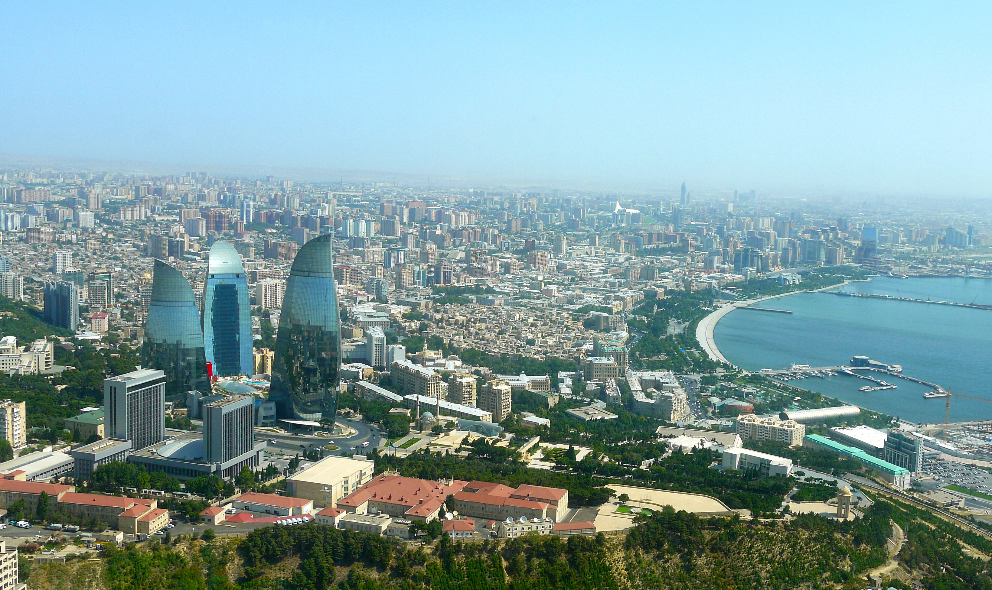
巴库(Baku, Баку)是阿塞拜疆首都和全国经济、文化中心。里海最大港口。位于阿普歇伦米岛南部,是石油工业中心,有“石油城”之誉。也是前苏联外高加索最大城市。 巴库由10个行政区和46个城镇组成,面积2200平方公里。人口182.88万。1月平均气温为4℃,7月平均气温为27.3℃。 在18世纪,巴库为巴库汗国都城。19世纪70年代开始工业性采油,19世纪末成为外高加索工业中心和石油基地,有22大炼油基地,其他工业多与石油有 关。1991年8月成为独立后阿塞拜疆的首都。城市西部的比比埃巴特区为老采油区。东部的基什雷区和邵武勉区为重要工业区。石油是巴库的经济命脉。石油开 采正向深处和外围海域发展。以石油、天然气开采和石油加工为主要工业,还有石油机械、电力和轻工 、食品工业。外高加索主要铁路枢纽,铁路通罗斯托夫、第比利斯和埃里温。有输油管道通黑海港口巴统。巴库是里海航运中心,可泊中等吨位船舶。城市中部为行 政、文化和居住区。建有科学院,大学和博物馆。里海最大港口,有“石油城”之誉。市内建有地铁,有阿塞拜疆科学学院、阿塞拜疆大学、石油化工学院等多所高 等院校。城市的中部是行政、文化区域,有历史博物馆和艺术博物馆。老城区以旧要塞为中心。 巴库是一座有着悠久历史的古城,城内有众多名胜古迹,如11世纪建造的瑟纳克一卡尔清真寺塔,12世纪的克孜一卡拉瑟塔楼,13世纪的巴伊洛夫石堡,15 世纪的希尔凡王宫及17世纪的汗王宫殿至今保存完好。2000年联合国教科文组织将巴库墙城及城内的希尔梵国王宫殿和少女塔作为文化遗产,列入《世界遗产 名录》。(Quelle:http://you.kuxun.cn)
巴库(阿塞拜疆语:Bakı,[bɑˈcɯ] (ⓘ))是阿塞拜疆的首都、经济文化中心。巴库同时也是里海最大港口,外高加索最大城市[4]。它的海拔是低于海平面28米(92英尺) ,使它成为世界上海拔最低的首都以及低于海平面的最大城市。面积2192平方公里,人口300万(2008年计算)[5]。巴库全市分为内城和新城两部分(亦有将苏联时期兴建区域分别划分的)。
在2007年,伊斯兰会议组织文化部长宣布巴库为2009年伊斯兰文化中心。为2015年第一届欧洲运动会主办国。巴库曾先后申办2016年夏季奥运会和2020年夏季奥运会,但皆因基础设施不完备没有入围。不过由于阿塞拜疆歌手艾尔与妮基在2011年欧洲歌唱大赛获得冠军,终使巴库获得举办2012年欧洲歌唱大赛的机会。
Baku (aserbaidschanisch Bakı / باکی; russisch Баку́ Baku) ist die Hauptstadt Aserbaidschans. Mit zwei Millionen Einwohnern in der Stadtprovinz ist Baku die bevölkerungsreichste und flächengrößte Stadt des Landes und des gesamten Kaukasus. Die Stadt an der Küste des Kaspischen Meeres ist Verkehrsknotenpunkt sowie Wirtschafts- und Kulturzentrum mit mehreren Universitäten, Hochschulen, Forschungsinstituten, Theatern und Museen. Durch die Lage innerhalb eines Erdölfördergebiets ist Baku der Knotenpunkt mehrerer Erdölleitungen und besitzt einen bedeutenden Erdölhafen. Baku kann aufgrund seiner günstigen Lage an mehreren historischen Handelswegen auf eine reiche Stadtgeschichte zurückblicken. In der Altstadt, die seit 2000 den Status eines UNESCO-Welterbes hat, sind zahlreiche Paläste, Moscheen und Festungsbauten erhalten geblieben.
バクー(Baku)は、アゼルバイジャン共和国の首都。カスピ海西岸に突き出したアブシェロン半島南岸に位置し、市街はバクー湾に面するように広がった港町である。行政的には11の行政区、48の町区に分割されており、2005年時点の総人口は2,045,815人[1]。アゼルバイジャン最大の都市であると同時に、南カフカース地域でも有数の大都市である。大規模な油田(バクー油田)をもち、帝政ロシア時代から石油の生産地として発展してきた。
日本語名のバクーはキリル文字綴りによるロシア語綴り・アゼルバイジャン語(アゼリー語)旧綴り Баку (Baku) に基づくが、アゼルバイジャン語の発音では母音の前で子音 k が軟音化するためカタカナ表記するならば「バキュ」に近く、現在アゼルバイジャンで使われているアゼルバイジャン語のラテン文字正書法では Bakı と綴る。バクーという名前の由来には諸説あるが、最も一般的なものは、ペルシャ語で「風が吹きつけた」という意味の "bād-kūbe"(バード・クーベ)から来ているとする説が一般的である。
気候は晴天が多く、乾燥している。寒気と暖気がぶつかることで起きる強風が時折吹き付け、先述した語源の根拠となっている。海岸は美しく、市街近郊には温泉や鉱泉がある。
市街の中心はその南西部にあり、イチェリ・シェヘル (İçəri Şəhər) すなわち「内城」と呼ばれる城壁に囲まれた旧市街と、帝政ロシア時代にその周囲に築かれた新市街とに分かれる。その周囲、北から東にかけての平地から丘陵の斜面一帯にソビエト連邦時代につくられた市街が広がっている。近年は豊富なオイルマネーをもとに近未来的な巨大建築物が出現し、「第二のドバイ」「第二のシンガポール」とも呼ばれている[2]。
Baku (/bəˈkuː/ bə-KOO, /ˈbɑːkuː/ BAH-koo; Azerbaijani: Bakı, IPA: [bɑˈcɯ]) is the capital and largest city of Azerbaijan, as well as the largest city on the Caspian Sea and of the Caucasus region, with a population of 2,262,600 (January 1, 2018). Baku is located 28 metres (92 ft) below sea level, which makes it the lowest lying national capital in the world and also the largest city in the world located below sea level. It is located on the southern shore of the Absheron Peninsula, alongside the Bay of Baku. At the beginning of 2009, Baku's urban population was estimated at just over two million people.[5] Officially, about 25 percent of all inhabitants of the country live in Baku's metropolitan area. Baku is the sole metropolis in Azerbaijan.
Baku is divided into twelve administrative districts (raions) and 48 townships. Among these are the townships on the islands of the Baku Archipelago, and the town of Oil Rocks built on stilts in the Caspian Sea, 60 kilometres (37 miles) away from Baku. The Inner City of Baku, along with the Shirvanshah's Palace and Maiden Tower, were inscribed as a UNESCO World Heritage Site in 2000. According to the Lonely Planet's ranking, Baku is also among the world's top ten destinations for urban nightlife.[6]
The city is the scientific, cultural, and industrial center of Azerbaijan. Many sizeable Azerbaijani institutions have their headquarters there. The Baku International Sea Trade Port is capable of handling two million tons of general and dry bulk cargoes per year.[7] In recent years, Baku has become an important venue for international events. It hosted the 57th Eurovision Song Contest in 2012, the 2015 European Games, 4th Islamic Solidarity Games, the F1 Azerbaijan Grand Prix since 2016, and will host UEFA Euro 2020. The city is bidding for Expo 2025 against Yekaterinburg, Russia and Osaka, Japan.
La ville de Bakou (azéri : Bakı, IPA: [bɑˈcɯ]) est la capitale de l'Azerbaïdjan. Elle se trouve dans l'est du pays, sur la rive sud de la péninsule d'Abşeron, au bord de la mer Caspienne. Son histoire débute au Ier millénaire avant Jésus-Christ, mais les traces écrites les plus anciennes ne datent que du Ve siècle.
En 2011, sa population est estimée à 2 045 815 habitants1 et 3 millions de personnes environ vivent dans l'agglomération.
Baku (pron. bakù[2]; in azero: Bakı?; in russo: Баку?), conosciuta anche come Baqy, Baky o Baki, in italiano Bacù[2], è la capitale, la più grande città e il più grande porto dell'Azerbaigian e di tutto il Caucaso.
È considerata una delle più antiche e più grandi città dell'Oriente. Situata sulla costa meridionale della penisola di Abşeron, la città si compone di tre parti principali: il centro, la vecchia Città Murata estesa sul territorio di 21,5 ettari e la parte della città costruita nell'epoca sovietica. La sua popolazione nel 2014 era stimata in 2.122.300 di abitanti.
Bakú (en azerí, Bakı, [bɑˈkɯ]) es la capital y ciudad más poblada de Azerbaiyán, del mar Caspio y del Cáucaso. Está situada en la costa sur de la península de Absheron, que se proyecta en el Caspio. La ciudad se compone de dos partes principales: el centro y la ciudad vieja interior. En enero de 2018 Bakú tenía una población de 2.262.600 habitantes,3 de los cuales 153.400 eran desplazados internos y 143.400 refugiados de la guerra de Nagorno Karabaj.
Bakú se divide en once distritos administrativos (raiones) y 48 municipios. Entre estos se encuentran los municipios de las islas de la bahía de Bakú y Neft Daşları construidas sobre pilotes en el mar Caspio, a 60 km de Bakú. El centro urbano de la ciudad, con el Palacio de los Shirvanshah y la Torre de la Doncella, fue inscrito por la Unesco como Patrimonio de la Humanidad en 2000. De acuerdo con la clasificación de Lonely Planet, Bakú también se encuentra entre los diez mejores destinos de vida nocturna urbana del mundo.4
La ciudad fue uno de los mayores centros petrolíferos de la antigua Unión Soviética y actualmente es el centro científico, cultural e industrial de Azerbaiyán. Muchas instituciones importantes de Azerbaiyán tienen su sede allí, incluyendo SOCAR, una de las cien principales empresas del mundo, entre otras.5 El Puerto de Comercio Marítimo Internacional de Bakú, protegido por las islas del archipiélago Bakú hacia el este y la península de Absheron al norte, es capaz de transportar dos millones de toneladas de carga general y seca a granel por año.6 La ciudad acogió el 57.º Festival de Eurovisión en 2012 y fue la sede de los Juegos Europeos 2015, es la sede del Gran Premio de Azerbaiyán de Fórmula 1 desde 2016 y será la sede del Campeonato Mundial de Ciclismo BMX en 2018 y de la EURO 2020.7
Баку́ (азерб. Bakı, МФА (азерб.): [bɑˈcɯ]) — столица Азербайджанской Республики, крупнейший промышленный, экономический и научно-технический центр Закавказья, а также самый крупный порт на Каспийском море и самый большой город на Кавказе[9][10].
Площадь территории, которая административно управляется Баку, составляет 2150 км²[1]; население данной территории — 2 181,8 тыс. жителей (на 1 января 2014 года). Баку расположен на южном берегу Апшеронского полуострова. Город по своей древности, величине территории и численности населения является одним из старинных и крупнейших городов Востока. Население всего Апшеронского полуострова (Бакинской агломерации) составляет 2 673,7 тыс. жителей[7]. Баку удостоен в 2010 году Программой ООН по окружающей среде (UNEP) звания одного из главных городов по проведению Всемирного дня окружающей среды. Подобные города избираются ежегодно. В 2010 году, наряду с Баку, этих званий были удостоены также Генуя (Италия) и Женева (Швейцария)[11].


曼谷(法语:Bangkok),官方名字功特玛哈那空[2](泰语:กรุงเทพมหานคร,转写:krung deːb mahaː nagara,皇家拉丁音译:Krung Thep Maha Nakhon,国际音标:[krūŋ tʰêːp mahǎː nákʰɔ̄ːn] 聆听 帮助·信息),泰国口语简称功特[2](泰语:กรุงเทพ,皇家拉丁音译:Krung Thep,国际音标:[krūŋ tʰêːp], 聆听 帮助·信息),是泰国首都与最大城市,在当地华人社区亦作泰京,为泰国政治、经济、贸易、交通、文化、科技、教育与各方面中心。位于昭披耶河东岸,近泰国湾。
Bangkok (thailändisch กรุงเทพมหานคร, Krung Thep Maha Nakhon, [kruŋ tʰêːp máʔhǎː náʔkʰɔːn],  anhören?/i; kurz กรุงเทพฯ, Krung Thep, [kruŋ tʰêːp]; historische Schreibung zum Teil auch Bankok[2]) ist seit 1782 die Hauptstadt des Königreichs Thailand. Sie hat einen Sonderverwaltungsstatus und wird von einem Gouverneur regiert. Die Hauptstadt hat 8,249 Millionen Einwohner (Volkszählung 2010) und ist die mit Abstand größte Stadt des Landes. In der Bangkok Metropolitan Region (BMR), der größten Metropolregion in Thailand, leben insgesamt 14,566 Millionen Menschen (Volkszählung 2010).[1]
Die Stadt ist das politische, wirtschaftliche und kulturelle Zentrum Thailands mit Universitäten, Hochschulen, Palästen und über 400 Wats (buddhistische Tempelanlagen und Klöster) sowie wichtigster Verkehrsknotenpunkt des Landes. In Bangkok ist auch die Wirtschafts- und Sozialkommission für Asien und den Pazifik (UNESCAP) beheimatet. Mit mehr als 17 Millionen ausländischen Touristen war Bangkok im Jahr 2013 die meistbesuchte Stadt der Welt, bevor sie 2014 wieder von London abgelöst wurde und seither auf Platz 2 rangiert.[3] Seit 2016 steht Bangkok mit über 20 Millionen Touristen jährlich auf Platz 1 der meistbesuchten Städte der Welt.
バンコク都(バンコクと、フランス語: Bangkok,[bāːŋ kɔ̀ːk], 聴く[ヘルプ/ファイル])正式名称クルンテープマハーナコーン(กรุงเทพมหานคร,[krūŋ tʰêːp mahǎː nákʰɔ̄ːn])は[1]、タイ王国の首都。タイでは、クルンテープ(กรุงเทพ,[krūŋ tʰêːp], 聴く[ヘルプ/ファイル])の通称で呼ばれている[2]。
人口8,249,117人(2010年)、面積1568.737 km2。都市圏人口は2018年時点で1600万人を超えており、世界有数の大都市圏を形成している[3]。ASEAN経済の中心地で、東南アジア屈指の世界都市でもある。
タイの王宮や政治の中枢機関が集中しているだけでなく、交通と宿泊施設の整ったバンコクは多くの各国要人を招き、アジアで2番目に多くの国際会議が開かれる都市であり[4]、政治的に多大な影響力を持つ。
Bangkok,[a] officially known in Thai as Krung Thep Maha Nakhon[b] and colloquially as Krung Thep,[c] is the capital and most populous city of Thailand. The city occupies 1,568.7 square kilometres (605.7 sq mi) in the Chao Phraya River delta in central Thailand and has an estimated population of 10.539 million as of 2020, 15.3 percent of the country's population. Over 14 million people (22.2 percent) lived within the surrounding Bangkok Metropolitan Region at the 2010 census, making Bangkok an extreme primate city, dwarfing Thailand's other urban centres in both size and importance to the national economy.
Bangkok traces its roots to a small trading post during the Ayutthaya Kingdom in the 15th century, which eventually grew and became the site of two capital cities, Thonburi in 1768 and Rattanakosin in 1782. Bangkok was at the heart of the modernization of Siam, later renamed Thailand, during the late-19th century, as the country faced pressures from the West. The city was at the centre of Thailand's political struggles throughout the 20th century, as the country abolished absolute monarchy, adopted constitutional rule, and underwent numerous coups and several uprisings. The city, incorporated as a special administrative area under the Bangkok Metropolitan Administration in 1972, grew rapidly during the 1960s through the 1980s and now exerts a significant impact on Thailand's politics, economy, education, media and modern society.
The Asian investment boom in the 1980s and 1990s led many multinational corporations to locate their regional headquarters in Bangkok. The city is now a regional force in finance and business. It is an international hub for transport and health care, and has emerged as a centre for the arts, fashion, and entertainment. The city is known for its street life and cultural landmarks, as well as its red-light districts. The Grand Palace and Buddhist temples including Wat Arun and Wat Pho stand in contrast with other tourist attractions such as the nightlife scenes of Khaosan Road and Patpong. Bangkok is among the world's top tourist destinations, and has been named the world's most visited city consistently in several international rankings.
Bangkok's rapid growth coupled with little urban planning has resulted in a haphazard cityscape and inadequate infrastructure. Despite an extensive expressway network, an inadequate road network and substantial private car usage have led to chronic and crippling traffic congestion, which caused severe air pollution in the 1990s. The city has since turned to public transport in an attempt to solve the problem, operating five rapid transit lines and building other public transit, but congestion still remains a prevalent issue. The city faces long-term environmental threats such as sea level rise due to climate change.
Bangkok (thaï : กรุงเทพมหานคร, Krungthep Mahanakhon) est la capitale de la Thaïlande. La ville a également le statut de province.
La ville occupe une superficie de 1 569 km2 dans le delta du fleuve Chao Phraya en Thaïlande centrale et son nombre d’habitants est supérieur à 9 millions, plus de 19 millions de personnes habitent l’aire métropolitaine de la capitale, soit plus que tous les autres centres urbains du pays.
Les racines de Bangkok remontent à un petit comptoir commercial créé durant le Royaume d’Ayutthaya au xve siècle au bord du fleuve Chao Phraya qui prend de l’importance avant de devenir le site d’une première capitale, Thonburi, en 1768. Mais la date officielle de sa fondation par Rama Ier, premier roi de la dynastie Chakri, est le 6 avril 1782, sur l’autre rive du fleuve. Bangkok s’inscrit au xixe siècle au cœur du mouvement de modernisation du royaume de Siam, alors que le pays subit la pression des nations colonisatrices européennes. La ville est ensuite au xxe siècle le théâtre de l’évolution politique de la Thaïlande, notamment avec l’abolition de la monarchie absolue, l’adoption d’une constitution, et plusieurs soubresauts politiques parfois violents. La ville a connu une formidable croissance à partir des années 1960 et exerce aujourd’hui une influence centrale sur la vie politique, économique, culturelle, universitaire et médiatique de la Thaïlande1.
Le boom économique asiatique des années 1980 et 1990 a amené beaucoup d’entreprises multinationales à installer leur siège régional à Bangkok. La ville est un important pôle d’affaires. C’est également une plateforme internationale pour les transports et la santé, tout comme pour les arts, la mode, les spectacles et le tourisme. Bangkok fait partie des villes les plus visitées au monde.
Bangkok (in thailandese: บางกอก?), in thai ufficialmente denominata Krung Thep Maha Nakhon o Krung Thep (in thailandese: กรุงเทพมหานคร?, กรุงเทพฯ; pronuncia[?·info]), è la capitale e la città più estesa e popolosa della Thailandia, situata lungo il fiume Chao Phraya, nei pressi del golfo della Thailandia. Secondo il censimento del 2010, aveva una popolazione di oltre 8,3 milioni di abitanti, pari al 12,6% del totale del paese, mentre erano oltre 14,6 milioni (22,2%) quelli che vivevano nella regione metropolitana, che comprende anche le province circostanti.[1] Tra le città più popolose e trafficate del mondo,[2] nonché una delle destinazioni preferite del turismo mondiale, a partire dalla seconda metà del XX secolo ha conosciuto un rapidissimo sviluppo industriale, rappresentando una delle città economicamente più dinamiche del sud-est asiatico.
Bangkok u oficialmente Krung Thep Mahanakhon ([bāːŋ kɔ̀ːk] en tailandés, กรุงเทพมหานคร o กรุงเทพ [krūŋ tʰêːp mahǎː nákʰɔ̄ːn] (?·i), RTGS: Krung Thep Mahanakhon traducido como «La ciudad de los ángeles»)1 es la capital y ciudad principal de Tailandia.2 Aunque el nombre oficial de la capital no es Bangkok, es comúnmente empleado internacionalmente para referirse a la ciudad.3
Bangkok significa «aldea de la ciruela silvestre» y es el nombre de una parte del lado del río Thon Buri. Así pues, Bangkok es conocida como Krung Thep Mahanakhon. Fue un pequeño puesto de comercio en la desembocadura del río Chao Phraya durante el reino de Ayutthaya. Llegó al primer plano de Siam, cuando recibió el estatus de ciudad capital en 1768 después de la quema de Ayutthaya.4 Sin embargo el actual reino Rattanakosin no comenzó hasta 1782 cuando Rama I trasladó la capital a la isla de Rattanakosin, después de la muerte del rey Taksin. La capital de Rattanakosin es ahora formalmente llamada "Phra Nakhon" (en tailandés: พระนคร), perteneciente a los antiguos límites en el núcleo de la metrópolis y el nombre de Bangkok incorpora la acumulación urbana desde el siglo XVIII, con su propia administración pública y gobernador.
Durante los últimos doscientos años Bangkok ha crecido hasta llegar a ser el centro político, social y económico de Tailandia ampliando su pujanza hacia Indochina y el Sudeste asiático. Su influencia en el arte, la política, moda, educación y entretenimiento, así como en los negocios, le ha proporcionado a Bangkok el estatus de ciudad global. En 2016, según un informe elaborado por MasterCard, fue reconocida como la ciudad más visitada por turistas extranjeros con 21,47 millones superando a Londres.5
La ciudad tenía una población de alrededor de 8.5 millones de habitantes, mientras que el área de gran Bangkok posee 11.971.000 habitantes (a enero de 2008).6 Esto, a su vez, ha cambiado el país ya que ha pasado de ser una población tailandesa homogénea a una heterogénea donde se incluye ciudadanos de procedencia occidental, con grupos de India o China, otorgando a la ciudad un estatus cosmopolita.
Бангко́к[6], в Таиланде используется название Крунгте́п[7] (тайск. กรุงเทพฯ, Крунгтхеп[8], или กรุงเทพมหานคร, Крунг Тхеп Маха Накхон[9]) — столица и самый крупный город Таиланда с населением 5,6 млн чел. (2011). Имя, данное городу при основании, попало в Книгу рекордов Гиннесса как самое длинное название города в мире. Бангкок раскинулся на восточном берегу реки Чаупхраи, недалеко от её впадения в Сиамский залив.
Один из наиболее быстрорастущих (в том числе экономически) городов Юго-Восточной Азии. Занимает площадь свыше 1,5 тыс. км². Местные жители считают свой город зарождающимся новым региональным центром, способным соперничать с такими городами, как Сингапур и Гонконг. Бангкок является также одним из наиболее привлекательных для туристов городов мира[10].
Столичный округ и пять соседних провинций (Нонтхабури, Самутпракан, Патхумтхани, Самутсакхон и Накхонпатхом) образуют агломерацию Большой Бангкок.

北海市(邮政式拼音:Pakhoi)是中华人民共和国广西壮族自治区下辖的地级市,位于广西南部,北部湾沿岸。南流江由北向西南流入海。市境东与玉林市及广东省湛江市毗邻,北与钦州市相接,西面与南面临北部湾。全市总面积3,989平方公里,人口162.57万,市人民政府驻海城区。北海市是沿海开放城市,国家历史文化名城。
北海地处广西壮族自治区南端,北部湾东北岸。位于东经108°50′45″~109°47′28″,北纬20°26′~21°55′34″之间,西北距自治区首府南宁206公里,东距湛江198公里,东南距海口市147海里。市区南北西三面环海,有涠洲(24.74平方公里)、斜阳(1.8平方公里)两个海岛,涠洲距市区大约20.2海里。北海地区海岸线总长达500多公里。
北海,别名“珠城”,是广西壮族自治区地级市,民国15年(1926年)成立北海市,建国后依次隶属广东省钦廉专区(先驻北海市后驻钦州镇)、广西省钦州专区(治所在钦州镇和廉州镇)、广东省合浦专区(治所在廉州镇)、广西壮族自治区钦州地区(治所在钦州镇)。 地处广西壮族自治区南端,北部湾东北岸。北海是我国最早的对外通商口岸和海上“丝绸之路”起点之一,历史上是云贵、川、桂、湘、鄂等省与海外贸易的主要商品集散地之一。 西北距首府南宁206公里,东距广东湛江198公里,东南距海南海口市147海里。地势总体呈北高南低,地形平坦开阔;气候属海洋性季风气候,具有典型的亚热带特色;下辖3个区、1个县,总面积3337平方千米 。根据第七次人口普查数据,截至2020年11月1日零时,北海市常住人口为1853227人。
北海是古代“海上丝绸之路”的重要始发港,是国家历史文化名城、广西北部湾经济区重要组成城市,是中国西部地区唯一列入全国首批14个进一步对外开放的沿海城市,也是中国西部唯一同时拥有深水海港、全天候机场、高速铁路和高速公路的城市。
2018年11月,入选中国城市全面小康指数前100名。 2020年入选“2020中国最宜置业百佳县市”。 北海是中国网红城市,2020年入选“2020网红城市百强榜单”。 2020年~2021年度获得2020年中国十大秀美之城。 2021年北海市生产总值为1504.4亿元,同比增长8.8%。
Beijing Shi-BJ
China
Chinese Super League 2019
 Financial
***Global Financial Center
History
N 2000 - 2100 AD
History
L 1000 - 1500 AD
History
M 1500 - 2000 AD
International cities
***Global Urban Economic Competitiveness
ITU World Championship Series
Beijing-Hangzhou Grand Canal
League of Legends
League of Legends World Championship
Olympic Summer Games
2022 Winter Olympics
Silk road
Shanghai Cooperation Organization
Financial
***Global Financial Center
History
N 2000 - 2100 AD
History
L 1000 - 1500 AD
History
M 1500 - 2000 AD
International cities
***Global Urban Economic Competitiveness
ITU World Championship Series
Beijing-Hangzhou Grand Canal
League of Legends
League of Legends World Championship
Olympic Summer Games
2022 Winter Olympics
Silk road
Shanghai Cooperation Organization
 Sport
Triathlon
World Heritage
Sport
Triathlon
World Heritage
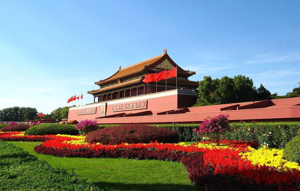
北京,简称“京”,是中华人民共和国的首都、直辖市、国家中心城市、超大城市、国际大都市,全国政治中心、文化中心、国际交往中心、科技创新中心,是中国共产党中央委员会、中华人民共和国中央人民政府、全国人民代表大会、中国人民政治协商会议全国委员会、中华人民共和国中央军事委员会所在地,也是中部战区司令部驻地。
北京位于华北平原北部,背靠燕山,毗邻天津市和河北省。北京的气候为典型的北温带半湿润大陆性季风气候。
北京是首批国家历史文化名城和世界上拥有世界文化遗产数最多的城市,三千多年的历史孕育了故宫、天坛、八达岭长城、颐和园等众多名胜古迹。早在七十万年前,北京周口店地区就出现了原始人群部落“北京人”。公元前1045年,北京成为蓟、燕等诸侯国的都城。公元938年以来,北京先后成为辽陪都、金中都、元大都、明、清国都。1949年10月1日成为中华人民共和国首都。
北京被全球权威机构GaWC评为世界一线城市 。联合国报告指出,北京人类发展指数居中国城市第二位 。2017年,北京人均可支配收入达到57230元,社会消费品零售总额11575.4亿元 。北京住户存款总额和人均住户存款均居全国第一 。2017年,北京高新技术企业达到20183家。 福布斯2017年“中国大陆最佳商业城市排行榜”排第3位。
2015年7月31日,国际奥委会主席巴赫宣布北京携手张家口获得2022年冬季奥林匹克运动会的举办权。北京由此成为全球首个既举办过夏季奥运会又将举办冬季奥运会的城市。
北京是一座有着三千多年历史的古都,在不同的朝代有着不同的称谓,大致算起来有二十多个别称。
燕都,据史书记载,公元前1122年,周武王灭商以后,在燕封召公。燕都因古时为燕国都城而得名。战国七雄中有燕国,据说是因临近燕山而得国名,其国都称为“燕都”。
幽州,远古时代的九州之一。幽州之名,最早见于《尚书·舜典》:“燕曰幽州。”两汉、魏、晋、唐代都曾设置过幽州,所治均在今天的北京一带。
京城,京城泛指国都,北京成为国都后,也多将其称为京城。
南京,辽太宗会同元年(938年),将原来的幽州升为幽都府,建号南京,又称燕京,作为辽的陪都。当时辽的首都在上京。
大都,元代以金的离宫今北海公园为中心重建新城,元世祖至元九年(1272年)改称大都,俗称元大都。
北平,明代洪武元年(1368年),朱元璋灭掉元朝后,为了记载平定北方的功绩,将元大都改称北平。
北京,明永乐元年(1403年),明成祖朱棣永乐皇帝取得皇位后,将他做燕王时的封地北平府改为顺天府,建北京城,并准备迁都城于此,这是正式命名为北京的开始,至今已有600余年的历史。
京师,明成祖于永乐十八年(1420年)迁都北京,改称京师,直至清代。
京兆,民国二年(1913年)废顺天府,翌年置京兆地方,直隶中央,其范围包括今天的北京大部分地区,民国十七年(1928年)废京兆地方,改北京为北平。
Peking (chinesisch 北京, Pinyin Běijīng, W.-G. Pei-ching auch Beijing, [pei˨˩tɕiŋ˥˥], deutsch historisch Pekingen[2]) ist die Hauptstadt der Volksrepublik China. Der Name bedeutet Nördliche Hauptstadt (vgl. Nanjing für Südliche Hauptstadt). Peking hat eine über dreitausendjährige Geschichte und ist heute eine regierungsunmittelbare Stadt, das heißt, sie ist direkt der Zentralregierung unterstellt und damit Provinzen, autonomen Gebieten und Sonderverwaltungszonen gleichgestellt.
Das gesamte 16.807 Quadratkilometer große (etwas größer als Schleswig-Holstein) Verwaltungsgebiet Pekings hat 21,5 Millionen Einwohner (Stand: März 2016).[3] Es stellt kein zusammenhängendes Stadtgebiet dar, mit seiner dominierenden ländlichen Siedlungsstruktur ist es eher mit einer Provinz vergleichbar.[4] Von der Gesamtbevölkerung sind 11,8 Millionen registrierte Bewohner mit ständigem Wohnsitz (戶口 / 户口, hùkǒu) und 7,7 Millionen temporäre Einwohner (流動人口 / 流动人口, liúdòng rénkǒu) mit befristeter Aufenthaltsgenehmigung (暫住證 / 暂住证, zànzhùzhèng).[5] Wird die Kernstadt (hohe Bebauungsdichte und geschlossene Ortsform) als Grundlage genommen, leben in Peking 7,7 Millionen Menschen mit Hauptwohnsitz (2007).[6] Der Ballungsraum (einschließlich Vororte) hat 11,8 Millionen Einwohner (2007).[7] Ab 2017 soll die Metropole Kern einer Megalopolis von 130 Millionen Einwohnern namens Jing-Jin-Ji werden.
Peking stellt als Hauptstadt das politische Zentrum Chinas dar. Aufgrund der langen Geschichte beherbergt Peking ein bedeutendes Kulturerbe. Dies umfasst die traditionellen Wohnviertel mit Hutongs, den Tian’anmen-Platz (chinesisch Platz am Tor des Himmlischen Friedens), die 1987 von der UNESCO zum Weltkulturerbe erklärte Verbotene Stadt, den neuen und alten Sommerpalast und verschiedene Tempel, wie z. B. den Himmelstempel, den Lamatempel und den Konfuziustempel.(2012)
北京市(ペキンし、中国語: 北京市、拼音: Běijīng)は、中華人民共和国の首都である。
行政区画上は直轄市であり、中国の華北の中央に位置する。人口は2152万(2014年)であり、中国では上海に次ぐ第二の都市。世界有数のメガシティであり、極めて高い影響力を有する世界都市でもある。古くは大都・燕京・北平とも呼ばれた。
春秋戦国時代には燕の首都で薊(けい)と称された。周の国都洛陽からは遠く離れ、常に北方の匈奴などの遊牧民族の侵入による被害を受ける辺境であった。秦漢代には北平(ほくへい)と称されるが、満州開発が進み、高句麗など周辺国の勢力が強大となると、戦略上、また交易上の重要な拠点として重視されるようになった。北京市に隣接する河北省涿郡(たくぐん)は三国志の英雄劉備の故郷で知られるとともに隋の煬帝が築いた大運河の北の起点とされている。
唐末五代の騒乱期、内モンゴルから南下してきた遼朝は、後晋に対し軍事支援を行った代償として北京地方を含む燕雲十六州を割譲された。遼はこの都市を副都の一つ南京と定めた。その後金朝が遼を滅ぼし支配権を獲得すると、金は北京に都城を定め中都とした。更にモンゴル帝国(元朝)が金を滅ぼすと大都として元朝の都城となり、カラコルムに代わってモンゴル帝国の中心となった。
朱元璋が元を北方に駆逐し明朝が成立すると、名称は北平に戻され、都城は南京に定められた。しかし、燕王に封じられ北京を拠点とした朱棣(後の永楽帝)は、1402年に建文帝に対し軍事攻撃を行い政権を奪取。皇帝に即位した後北京遷都を実行し地名を北京に改めた。辛亥革命後は中華民国北洋政府は北京を首都と定めたが、南京を首都と定めた蒋介石を中心とする国民政府は、「政府直轄地域」を意味する直隷省を1928年6月15日に河北省へ、北の首都を意味する北京を北平(ほくへい、ベイピンBěipíng)へと、それぞれ改称した。1937年から1945年まで続いた日本軍占領期は北京の名称が用いられ(公式には1940年に改名)、日本の敗戦によって再び北平に改称された。
1949年10月1日の中華人民共和国成立により新中国の首都とされた北京(北平)は再び北京と改称され現在に至っている。しかし、中華人民共和国の存在を承認せず、南京を公式な首都として大陸地区への統治権を主張する中華民国(台湾)では、現在でも公式名称として「北平」の名称が用いられている。
Beijing (/beɪˈdʒɪŋ/;[10] Mandarin: [pèi.tɕíŋ] ( listen)), formerly romanized as Peking,[11] is the capital of the People's Republic of China, the world's third most populous city proper, and most populous capital city. The city, located in northern China, is governed as a municipality under the direct administration of central government with 16 urban, suburban, and rural districts.[12] Beijing Municipality is surrounded by Hebei Province with the exception of neighboring Tianjin Municipality to the southeast; together the three divisions form the Jingjinji metropolitan region and the national capital region of China.[13]
Beijing is an important capital and global power city, and one of the world's leading centers for politics, economy and business, finance, education, culture, innovation and technology, architecture, language, and diplomacy. A megacity, Beijing is the second largest Chinese city by urban population after Shanghai and is the nation's political, cultural, and educational center.[14] It is home to the headquarters of most of China's largest state-owned companies and houses the largest number of Fortune Global 500 companies in the world.[15] It is also a major hub for the national highway, expressway, railway, and high-speed rail networks. The Beijing Capital International Airport has been the second busiest in the world by passenger traffic since 2010,[16] and, as of 2016, the city's subway network is the busiest and second longest in the world.
Combining both modern and traditional architecture, Beijing is one of the oldest cities in the world, with a rich history dating back three millennia. As the last of the Four Great Ancient Capitals of China, Beijing has been the political center of the country for most of the past eight centuries,[17] and was the largest city in the world by population for much of the second millennium A.D.[18] Encyclopædia Britannica notes that "few cities in the world have served for so long as the political headquarters and cultural center of an area as immense as China."[19] With mountains surrounding the inland city on three sides, in addition to the old inner and outer city walls, Beijing was strategically poised and developed to be the residence of the emperor and thus was the perfect location for the imperial capital. The city is renowned for its opulent palaces, temples, parks, gardens, tombs, walls and gates.[20] It has seven UNESCO World Heritage Sites – the Forbidden City, Temple of Heaven, Summer Palace, Ming Tombs, Zhoukoudian, and parts of the Great Wall and the Grand Canal – all popular locations for tourism.[21] Siheyuans, the city's traditional housing style, and hutongs, the narrow alleys between siheyuans, are major tourist attractions and are common in urban Beijing.
Pékin2 (en chinois : 北京 ; pinyin : běijīng ; API : [pe˨˩˦i.tɕi˥ŋ] Écouter la prononciation en mandarin, littéralement « capitale du nord »), également appelée Beijing, est la capitale de la République populaire de Chine. Située dans le nord du pays, la municipalité de Pékin (北京市, abrégé en 北京), d'une superficie de 16 800 km2, borde la province du Hebei ainsi que la municipalité de Tianjin. Pékin est considérée comme le centre politique et culturel de la Chine, tandis que Hong Kong et Shanghai dominent au niveau économique.
D'abord ville périphérique de l'empire chinois sous les Han et les Tang, elle prend de l'importance lorsque les Jurchen, qui fondent la dynastie Jin, la choisissent comme leur capitale principale en 1153. Le prince mongol Kubilai Khan en fait de même sous le nom de Dadu (« grande métropole »), enfin les Ming y transfèrent leur administration en 1421, parachevant le choix de Pékin comme capitale de la Chine. Située à proximité de la Grande Muraille, Pékin abrite des monuments célèbres comme la Cité interdite et le Temple du ciel, qui sont inscrits au patrimoine mondial. De nombreuses réalisations architecturales et structurelles ont modifié la ville à l'occasion des Jeux olympiques d'été dont elle a été l'hôte en 2008. Beijing a été choisie par le CIO pour organiser les Jeux olympiques d'hiver de 2022 et sera la première ville à avoir accueilli les deux éditions de l'évènement sportif international.
Avec 21,15 millions d'habitants en 2013, Pékin est la deuxième ville la plus peuplée de Chine après Shanghai. La zone urbaine compte quant à elle 18 millions d'habitants. Le parler pékinois forme la base du mandarin standard. D'un point de vue économique, Pékin est la troisième ville de Chine par le PIB total derrière Shanghai et Hong Kong. Elle connaît une croissance économique très rapide, nettement plus de 10 % par an dans les années 2000. Un nouveau Central business district (CBD) est en construction.
Pechino (AFI: /peˈkino/[1]; in cinese 北京S, BěijīngP, letteralmente "capitale del nord", pronuncia in mandarino[?·info]) è la capitale della Cina e della municipalità omonima.
L'intera municipalità ha dimensioni pari a poco più della metà del Belgio avendone però quasi il doppio degli abitanti (21.516.000[senza fonte]). Pechino è la seconda città più popolata della Cina dopo Shanghai, la capitale di Stato più popolata al mondo, e la seconda città del mondo per popolazione. Confina esclusivamente con la provincia dell'Hebei e a sud-est con la municipalità di Tientsin.
Pekín, Pequín o Beijing (chino simplificado y tradicional: 北京, pinyin: Běijīng, Wade-Giles: Pei-ching, pronunciado: [pèi.tɕíŋ](![]() escuchar), literalmente «capital del Norte») es uno de los cuatro municipios que, junto con las veintidós provincias, cinco regiones autónomas y dos regiones administrativas especiales, conforman la República Popular China. Además Pekín es la capital del país y una de las ciudades más pobladas del mundo con 21 150 000 personas en 2013.2
escuchar), literalmente «capital del Norte») es uno de los cuatro municipios que, junto con las veintidós provincias, cinco regiones autónomas y dos regiones administrativas especiales, conforman la República Popular China. Además Pekín es la capital del país y una de las ciudades más pobladas del mundo con 21 150 000 personas en 2013.2
Situada en la periferia de la antigua civilización china, Pekín se convirtió en el baluarte de las potencias extranjeras que ocuparon China del Norte entre los siglos X y XII. La dinastía Liao estableció aquí su capital meridional, la más acreditada de las cinco del reino. La dinastía Jin, la siguiente dinastía "bárbara" emprendió un amplio proyecto urbanístico a imagen de la capital de los Song septentrionales, Kaifeng. En 1215 los mongoles arrasaron la ciudad, pero 50 años después Kublai Kan decidió edificar en ella la nueva capital.
En la zona centro-sur del trazado hipodámico se hallaba la colosal villa imperial que contenía el complejo de palacios imperiales. El emperador Yongle, el tercer Ming, decidió trasladar la capitalidad a Pekín. Las murallas del lado septentrional fueron trasladadas más hacia el Sur para que el complejo palaciego imperial, la llamada Ciudad Prohibida, quedase exactamente en el centro del plano. Así la estructura del nuevo Pekín representa la cima del urbanismo tradicional chino, basado en la organización introducida por los mongoles así como en la estructura de los palacios imperiales de Kaifeng y Nankín además de tomar en consideración las normas de la geomancia china (風水).
Pekín es uno de los cuatro municipios de China que poseen un estatus provincial y están bajo el control directo del gobierno central. Pekín ha sido municipalidad desde la creación de la República Popular China. Es una de las ciudades más pobladas de China, tan sólo superada por Shanghái en cuanto a población. Es considerada el corazón cultural, político y social de China.
Пеки́н (кит. 北京, пиньинь: Běijīng, палл.: Бэйцзин, буквально: «Северная столица») — столица и один из городов центрального подчинения Китайской Народной Республики. Пекин с трёх сторон окружён провинцией Хэбэй и граничит с Тяньцзинем на юго-востоке.
Это крупнейший железно- и автодорожный узел и один из основных авиаузлов страны. Кроме того, Пекин является политическим, образовательным и культурным центром КНР, в то время как главными экономическими центрами считаются Шанхай и Гонконг. Вместе с тем, в последнее время всё больше берёт на себя роль локомотива предпринимательской деятельности и основного поля для создания инновационных предприятий.
Входит в число четырёх древних столиц Китая. В 2008 году в городе прошли Летние Олимпийские игры. В 2022 году в городе пройдут Зимние Олимпийские игры.