
Deutsch-Chinesische Enzyklopädie, 德汉百科
 Xizang Zizhiqu-XZ
 Sport
China
Italy
Japan
Legend
Nepal
New Zealand
Austria
Poland
Switzerland
United States
United Kingdom
Xizang Zizhiqu-XZ
Sport
China
Italy
Japan
Legend
Nepal
New Zealand
Austria
Poland
Switzerland
United States
United Kingdom
Xizang Zizhiqu-XZ
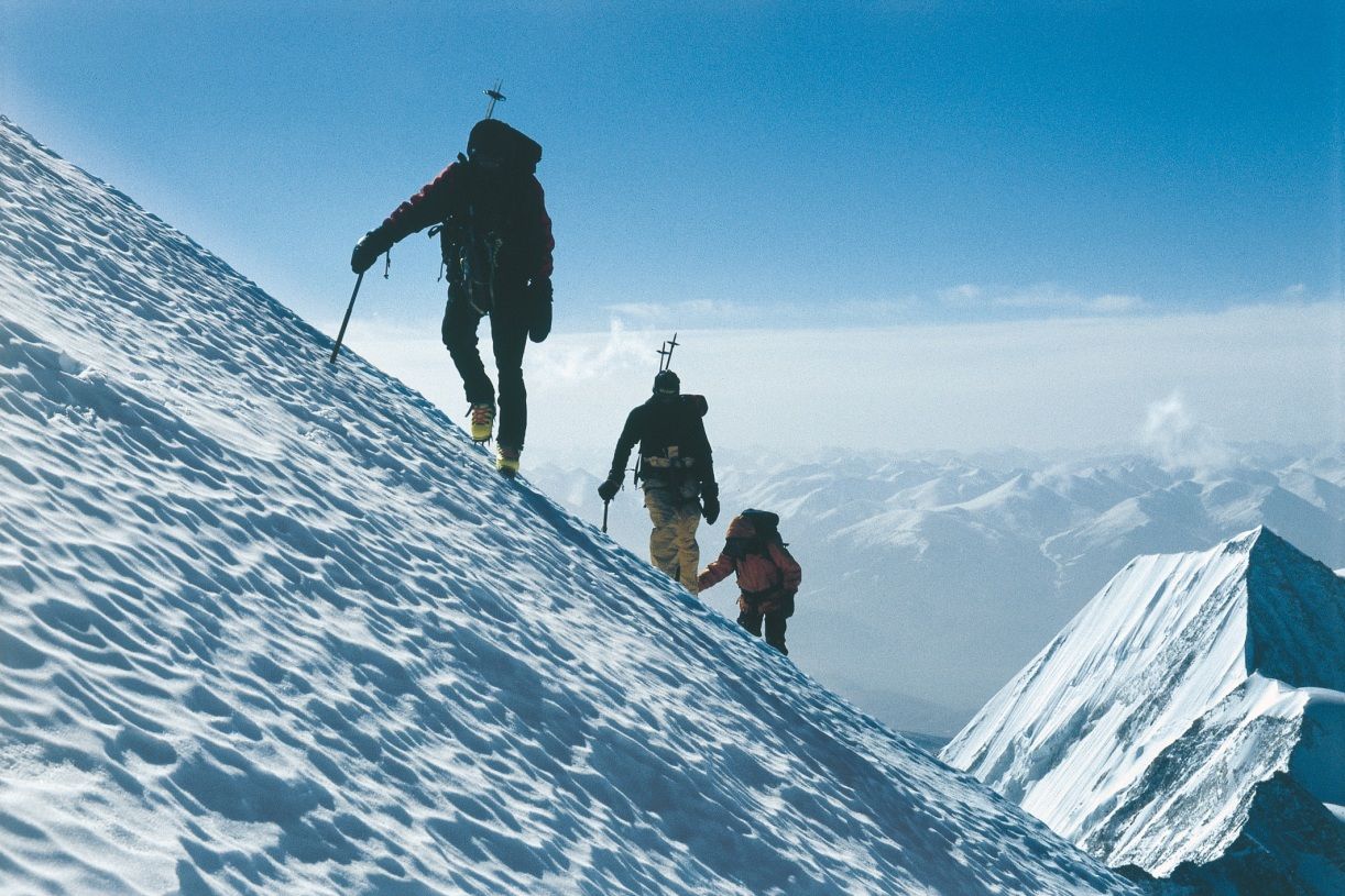
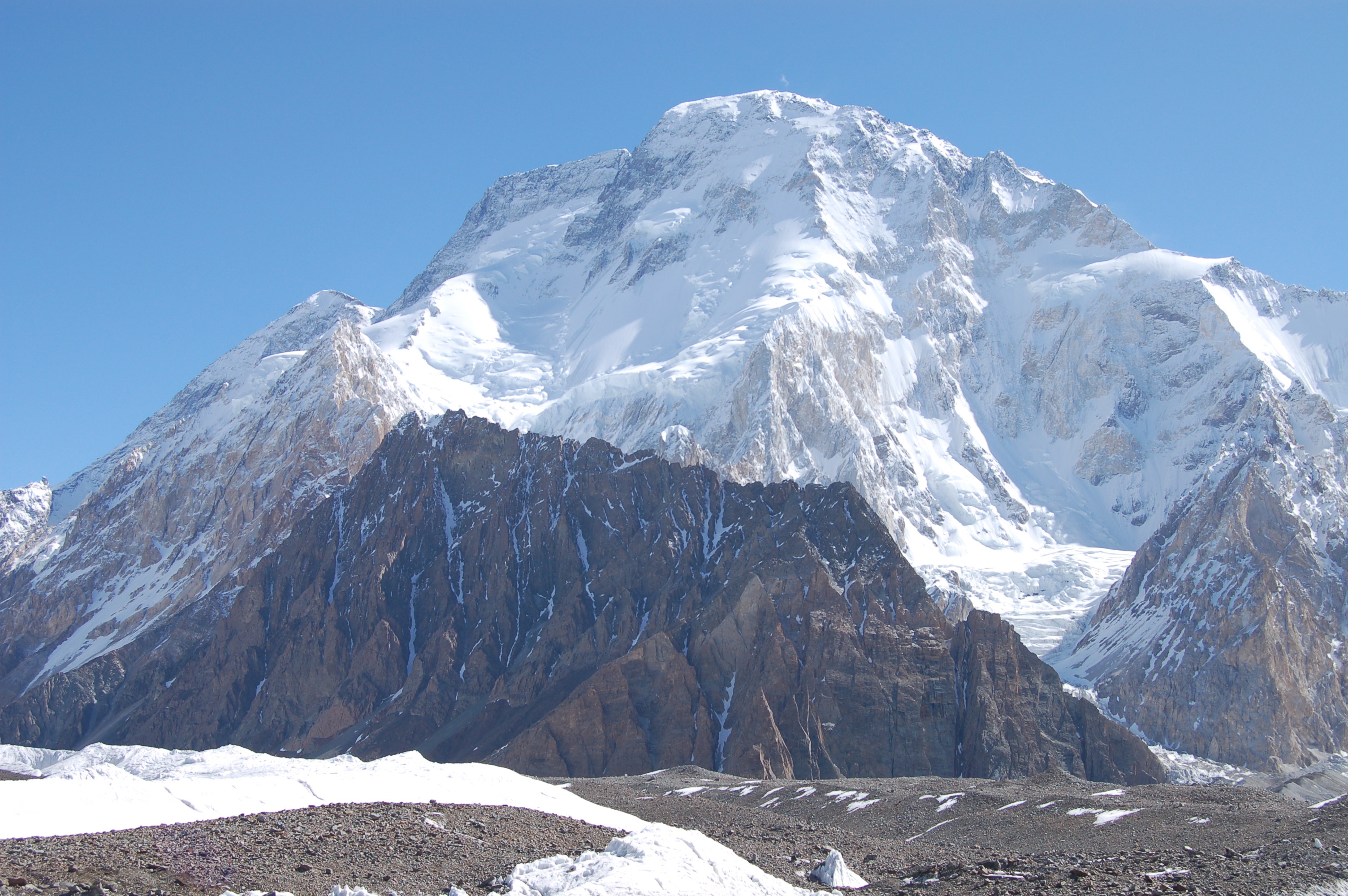
珠穆朗玛峰山体呈巨型金字塔状,威武雄壮昂首天外,地形极端险峻,环境异常复杂。雪线高度:北坡为5800—6200米,南坡为5500—6100米。东北山脊、 东南山脊和西山山脊中间夹着三大陡壁(北壁、东壁和西南壁),在这些山脊 和峭壁之间又分布着548条大陆型冰川,总面积达1457.07平方公里,平均厚度达7260米。冰川的补给主要靠印度洋季风带两大降水带积雪变质形成。冰川上 有千姿百态、瑰丽罕见的冰塔林,又有高达数十米的冰陡崖和步步陷井的明暗 冰裂隙,还有险象环生的冰崩雪崩区。(Quelle:http://news.xinhuanet.com)
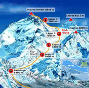
珠穆朗玛峰(藏文:ཇོ་མོ་གླང་མ;藏语拼音:qomolangma;威利:jo mo glang ma,香港称珠穆朗玛峰,台湾称圣母峰),中文简称珠峰,尼泊尔名萨加玛塔峰(尼泊尔语:सगरमाथा),英国名埃佛勒斯峰(英语:Mount Everest),为地球第一高峰,属于喜马拉雅山脉,位于中国西藏自治区与尼泊尔萨加玛塔专区边界上。2005年中国国家测绘局测量的岩面高为8,844.43米(29,017.2英尺),尼泊尔则使用传统的雪盖高8,848米(29,029英尺),BBC报道称2010年起两国官方互相承认对方的测量数据[5],中国国家测绘地理信息局则在2018年2月声明否认此说法,仍采用8,844.43米数据至今[6]。它除了是海拔最高的山峰之外,也是距离地心第五远的高峰。[7]它附近的高峰包括8,516米(27,940英尺)的洛子峰、7,855米(25,771英尺)的努子峰和7,580米(24,870英尺)的章子峰。
清朝经过测绘于1719年出版的全国地图上称此峰为“朱姆朗马阿林”,但没有标出高度或用经纬度标出其位置。1856年英属印度测量局首次公布此峰的经纬度及海拔高度,主张此峰8,840米(29,000英尺)是世界第一高峰。1865年英国皇家地理学会接受印度测量局局长安德鲁·史考特·华欧的建议,将此峰命名为“埃佛勒斯峰”,以纪念前任局长乔治·埃佛勒斯。1952年,中国采用“珠穆朗玛峰”为官方名称。
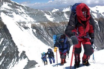
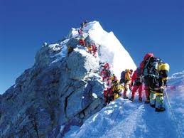
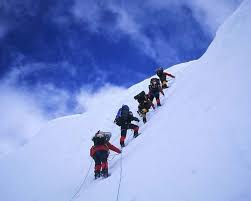
珠穆朗玛峰吸引了许多登山者。主要的攀登路线有两条,一条从尼泊尔东南部出发,经过与洛子峰之间的南坳登顶,称为“标准路线”;另一条则从西藏的北部出发,经过与章子峰之间的北坳登顶。从标准路线登顶对登山技术的挑战不算高,但这条路线的风险包括雪崩、摔落山谷、高山症、冻伤和通过昆布冰瀑的危险。到2016年为止,山上有超过200具尸体,其中一些成为地标。[8][9]
据气象记载,珠穆朗玛峰山顶最低温度为-60°C,最低月平均温度为-35°C,全年平均温度为-29°C,参照北极、南极,因此也被称为“世界第三极”。[10]
Der Mount Everest ist ein Berg im Himalaya und mit einer Höhe von 8848 m der höchste Berg der Erde. Er gehört zu den 14 Achttausendern und zu den Seven Summits. Der Mount Everest ist seit 1856 nach dem britischen Landvermesser George Everest benannt. Auf Nepali heißt der Berg Sagarmatha, auf Tibetisch Qomolangma (deutsche Aussprache „Tschomolangma“; englische Umschrift Chomolungma).
Der Mount Everest befindet sich im Mahalangur Himal in der Region Khumbu in Nepal an der Grenze zu China (Autonomes Gebiet Tibet); der westliche und südöstliche seiner drei Gipfelgrate bilden die Grenze. Auf nepalesischer Seite ist er Teil des Sagarmatha-Nationalparks, der zum UNESCO-Welterbe gehört. Auf der Nordseite gehört er zum Qomolangma National Nature Reserve, das mit dem von der UNESCO ausgewiesenen Qomolangma-Biosphärenreservat korrespondiert.[1]
Edmund Hillary und Tenzing Norgay gelang am 29. Mai 1953 die Erstbesteigung des „dritten Pols“. Am 8. Mai 1978 bestiegen Reinhold Messner und Peter Habeler den Gipfel erstmals ohne zusätzlichen Sauerstoff.
エベレスト、エヴェレスト(英: Everest)、またはチョモランマ(チベット語: ཇོ་མོ་གླང་མ[1] Chomolungma, Qomolangma)、サガルマータ(ネパール語: सगरमाथा Sagarmāthā)は、ヒマラヤ山脈にある世界最高峰である。
エベレストはインド測量局(Survey of India)で長官を務めたジョージ・エベレストにちなんで命名された。
1920年代から長きにわたる挑戦の末、1953年にイギリス探検隊のメンバーでニュージーランド出身の登山家であるエドモンド・ヒラリーとネパール出身のシェルパであるテンジン・ノルゲイによって初登頂がなされた。
エベレストの標高については諸説あり、1954年にインド測量局が周辺12ヶ所で測定しその結果を平均して得られた8,848 mという数値が長年一般に認められてきた。1999年、全米地理学協会はGPSによる測定値が8,850mだったと発表した[2]。厳密には地殻変動などの影響によって標高は年々変動していると考えられている。
エベレストの南麓に位置するネパールのサガルマータ国立公園はユネスコの世界遺産に登録されている。
Mount Everest, known in Nepali as Sagarmatha (सगरमाथा) and in Tibetan as Chomolungma (ཇོ་མོ་གླང་མ), is Earth's highest mountain above sea level, located in the Mahalangur Himal sub-range of the Himalayas. The international border between Nepal (Province No. 1) and China (Tibet Autonomous Region) runs across its summit point.
The current official elevation of 8,848 m (29,029 ft), recognized by China and Nepal, was established by a 1955 Indian survey and subsequently confirmed by a Chinese survey in 1975.[1] In 2005, China remeasured the rock height of the mountain, with a result of 8844.43 m. There followed an argument between China and Nepal as to whether the official height should be the rock height (8,844 m., China) or the snow height (8,848 m., Nepal). In 2010, an agreement was reached by both sides that the height of Everest is 8,848 m, and Nepal recognizes China's claim that the rock height of Everest is 8,844 m.[5]
In 1865, Everest was given its official English name by the Royal Geographical Society, upon a recommendation by Andrew Waugh, the British Surveyor General of India. As there appeared to be several different local names, Waugh chose to name the mountain after his predecessor in the post, Sir George Everest, despite George Everest's objections.[6]
Mount Everest attracts many climbers, some of them highly experienced mountaineers. There are two main climbing routes, one approaching the summit from the southeast in Nepal (known as the "standard route") and the other from the north in Tibet. While not posing substantial technical climbing challenges on the standard route, Everest presents dangers such as altitude sickness, weather, and wind, as well as significant hazards from avalanches and the Khumbu Icefall. As of 2017, nearly 300 people have died on Everest, many of whose bodies remain on the mountain.[7]
The first recorded efforts to reach Everest's summit were made by British mountaineers. As Nepal did not allow foreigners into the country at the time, the British made several attempts on the north ridge route from the Tibetan side. After the first reconnaissance expedition by the British in 1921 reached 7,000 m (22,970 ft) on the North Col, the 1922 expedition pushed the north ridge route up to 8,320 m (27,300 ft), marking the first time a human had climbed above 8,000 m (26,247 ft). Seven porters were killed in an avalanche on the descent from the North Col. The 1924 expedition resulted in one of the greatest mysteries on Everest to this day: George Mallory and Andrew Irvine made a final summit attempt on 8 June but never returned, sparking debate as to whether or not they were the first to reach the top. They had been spotted high on the mountain that day but disappeared in the clouds, never to be seen again, until Mallory's body was found in 1999 at 8,155 m (26,755 ft) on the north face. Tenzing Norgay and Edmund Hillary made the first official ascent of Everest in 1953, using the southeast ridge route. Norgay had reached 8,595 m (28,199 ft) the previous year as a member of the 1952 Swiss expedition. The Chinese mountaineering team of Wang Fuzhou, Gonpo, and Qu Yinhua made the first reported ascent of the peak from the north ridge on 25 May 1960.[8][9]
L’Everest, en tibétain ཇོ་མོ་གླང་མ, Qomolangma ou encore Chomolungma, en népalais सगरमाथा, Sagarmāthā, aussi appelé mont Everest, est une montagne située dans la chaîne de l'Himalaya, à la frontière entre le Népal (province no 1 (en)) et la Chine (Tibet).
Il est aperçu par des Européens pour la première fois en 1847 puis, après quelques années d'observations et de calculs, son altitude est établie à 8 848 mètres et il est identifié comme le plus haut sommet du monde. Cette caractéristique lui vaut d'être baptisé de son nom actuel par les Occidentaux en 1865 et, dès les années 1920, de lui attirer l'intérêt des alpinistes qui se lancent à l'assaut de ses pentes. Plusieurs expéditions, en particulier britanniques, se succèdent depuis le versant nord au Tibet. Toutefois, les conditions climatiques extrêmes font leurs premières victimes, parmi lesquelles George Mallory et Andrew Irvine, en 1924, dont on ne saura probablement jamais avec certitude s'ils ont atteint le sommet. En 1950, le Népal autorise l'accès à la montagne depuis le sud offrant des possibilités d'ascension par l'arête Sud-Est, moins périlleuse. Finalement, trois ans plus tard, Edmund Hillary et Tensing Norgay réussissent à vaincre l'Everest. Dès lors, les exploits en tous genres s'enchaînent, alimentant les fantasmes populaires ; mais, en 1996, une série d'accidents mortels vient rappeler les dangers liés à la montagne, portant de nos jours à plus de 200 le nombre de victimes. Pourtant, le tourisme de masse se popularise, fragilisant le milieu naturel malgré les créations du parc national de Sagarmatha en 1976 et de la réserve naturelle du Qomolangma en 1988. Ainsi, plus de 14 000 alpinistes ont tenté l'ascension depuis 1922 et plus de 4 000 l'ont réussie, bien aidés, pour la majorité d'entre eux, par les porteurs sherpas.
Il monte Everest (pron. /ˈɛverest/[1]) è la vetta più alta del continente asiatico e della Terra con i suoi 8 848 m di altitudine s.l.m., situato nella catena dell'Himalaya assieme ad altri ottomila, al confine fra Cina e Nepal. Rientra dunque nelle cosiddette Sette Vette del Pianeta.
El monte Everest es la montaña más alta del planeta Tierra, con una altitud de 8.848 metros (29 029 pies) sobre el nivel del mar.1 Está localizada en el continente asiático, en la cordillera del Himalaya, concretamente en la subcordillera de Mahalangur Himal; marca la frontera entre China y Nepal, considerada como la frontera más alta del mundo.[cita requerida] El macizo incluye los picos vecinos Lhotse, 8516 m (27 940 pies); Nuptse, 7855 m (25 771 pies) y Changtse, 7580 m (24 870 pies).
 Geography
 Anhui Sheng-AH
Beijing Shi-BJ
Chongqing Shi-CQ
Fujian Sheng-FJ
Gansu Sheng-GS
Guangdong Sheng-GD
Guangxi Zhuangzu Zizhiqu-GX
Guizhou Sheng-GZ
Hainan Sheng-HI
Hebei Sheng-HE
Heilongjiang Sheng-HL
Henan Sheng-HA
Hongkong Tebiexingzhengqu-HK
Hubei Sheng-HB
Hunan Sheng-HN
Jiangsu Sheng-JS
Jiangxi Sheng-JX
Jilin Sheng-JL
Liaoning Sheng-LN
Macau Tebiexingzhengqu-MO
Nei Mongol Zizhiqu-NM
Ningxia Huizu Zizhiqu-NX
Qinghai Sheng-QH
Shaanxi Sheng-SN
Shandong Sheng-SD
Shanghai Shi-SH
Shanxi Sheng-SX
Sichuan Sheng-SC
Taiwan Sheng-TW
Tianjin Shi-TJ
Xinjiang Uygur Zizhiqu-XJ
Xizang Zizhiqu-XZ
Yunnan Sheng-YN
Zhejiang Sheng-ZJ
Anhui Sheng-AH
Beijing Shi-BJ
Chongqing Shi-CQ
Fujian Sheng-FJ
Gansu Sheng-GS
Guangdong Sheng-GD
Guangxi Zhuangzu Zizhiqu-GX
Guizhou Sheng-GZ
Hainan Sheng-HI
Hebei Sheng-HE
Heilongjiang Sheng-HL
Henan Sheng-HA
Hongkong Tebiexingzhengqu-HK
Hubei Sheng-HB
Hunan Sheng-HN
Jiangsu Sheng-JS
Jiangxi Sheng-JX
Jilin Sheng-JL
Liaoning Sheng-LN
Macau Tebiexingzhengqu-MO
Nei Mongol Zizhiqu-NM
Ningxia Huizu Zizhiqu-NX
Qinghai Sheng-QH
Shaanxi Sheng-SN
Shandong Sheng-SD
Shanghai Shi-SH
Shanxi Sheng-SX
Sichuan Sheng-SC
Taiwan Sheng-TW
Tianjin Shi-TJ
Xinjiang Uygur Zizhiqu-XJ
Xizang Zizhiqu-XZ
Yunnan Sheng-YN
Zhejiang Sheng-ZJ

 Religion
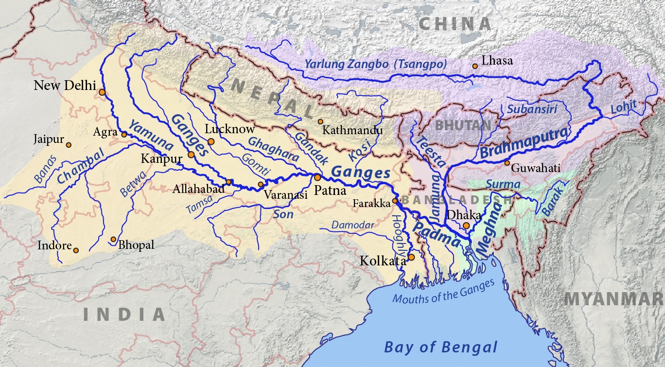
布拉马普特拉河,亚洲主要大河之一,被藏族视为“摇篮”和“母亲河”。以长度来说为中国第5大河(仅次于长江、黄河、黑龙江和珠江)、西藏地区第一大河,以水量来说是印度和孟加拉国的第二大河(仅次于恒河)。上游是世界海拔最高的大河,也是中国坡降最陡的大河。藏语中雅鲁藏布江意为“高山流下的雪水”,梵语中布拉马普特拉河意为“梵天之子”。它发源于西藏喜马拉雅山脉北麓的杰马央宗冰川,从藏南(印度称阿鲁纳恰尔邦)进入印度,在藏南(阿鲁纳恰尔邦)境内称底杭河(Dihang river)或香江(Siang river)。在藏南巴昔卡附近的印度阿萨姆邦境内与其他两河合流后始称布拉马普特拉河。流经孟加拉国后称为贾木纳河,于瓜伦多卡德与恒河汇合,形成巨大的恒河三角洲,最后注入孟加拉湾。全长为2900公里。
布拉马普特拉河(梵語:ब्रह्मपुत्र,印地語:ब्रम्हपुत्र)字面意思是“(印度教三主神之一的)梵天之子”,南亚的一条重要国际河流。
布拉马普特拉河的上游在中国境内,称为雅鲁藏布江,长2057km;流入印度后称为布拉马普特拉河,长644km;流入孟加拉国后称贾木纳河,长240km;在阿里恰与恒河汇流后称帕德玛河,长100km;在琴德普尔与梅格纳河汇合后仍称梅格纳河长241km;最后注入孟加拉湾。以水量、长度来说,此河是南亚第一大河。包括上游雅鲁藏布江在内的全长为2900公里。总流域面积6.22×10⁵km2,流域国有中国、印度、不丹、孟加拉国,四国分别占该河流域面积的51.1%、34%、6.7%、8.2%。
Der Brahmaputra ist der Hauptstrang des als Meghna in den Indischen Ozean mündenden wasserreichsten Stromes in Asien. Er fließt mit einer Länge von rund 3100 Kilometern bis zum Zusammenfluss mit dem Ganges durch das Gebiet der Staaten China, Indien und Bangladesch. Sein Lauf ist teils veränderlich, teils schwer zugänglich und quert mehrere Kulturräume, was zu vielen unterschiedlichen Namen für Teilabschnitte geführt hat.
Der nach Osten gerichtete Oberlauf des Brahmaputra in Tibet heißt auf Tibetisch Matsang bzw. Tachog Tsangpo (in Wylie-Transliteration: rta mchog gtsang po), auf Chinesisch Mǎquán Hé 馬泉河 / 马泉河; danach heißt er auf Tibetisch Yarlung Tsangpo ཡར་ཀླུང་གཙང་པོ (yar klung gtsang po), der Reinigende, nach anderer Quelle „vom höchsten Gipfel herabkommendes Wasser“, und auf Chinesisch Yǎlǔ Zàngbù Jiāng 雅魯藏布江 / 雅鲁藏布江.
Im indischen Bundesstaat Arunachal Pradesh hat der scharf nach Süden abgeknickte Fluss den Namen Dihang oder Siang. Nach einem Richtungswechsel nach Westen an der Einmündung des größten Nebenflusses, des Lohit, heißt er, nun den Bundesstaat Assam durchfließend, Brahmaputra (ब्रह्मपुत्र), was im Sanskrit „Sohn des Brahma“ bedeutet. Ein älterer Name dieses Flussabschnittes war (in Sanskrit-Schriften und in Teilen Assams) Luit oder Lohitya, da früher statt des größeren Dihang der Lohit als der Oberlauf galt. Heute wird der Name auf Hindi ब्रह्मपुत्र, Brahmaputra gesprochen, auf Assamesisch ব্ৰহ্মপুত্ৰ und auf Bengalisch ব্রহ্মপুত্র Brohmoputro.
Bei einer Wendung nach Süden tritt der Fluss in das Staatsgebiet von Bangladesch ein und führt teils ab dort, teils ab der Abzweigung des Alten Brahmaputra (früher der Hauptstrom) den Namen Jamuna. Ab dem Zusammentreffen mit dem deutlich weniger voluminösen Ganges schwenkt der Strom in dessen südöstliche Richtung ein und heißt nun Padma, bis er ab der Mündung des letzten großen Nebenflusses bis zur Mündung in den Golf von Bengalen dessen Namen Meghna annimmt.
ブラマプトラ川(ブラマプトラがわ、英:Brahmaputra River, ヒンディー語:ब्रह्मपुत्र Bramhaputra, ベンガル語:ব্রহ্মপুত্র Brohmoputro)は、チベットに発しバングラデシュでガンジス川と合流し、ベンガル湾へ注ぐ河川である。チベットではヤルンツァンポ川(表記によってはヤル・ツアンポー川とも。チベット語:ཡར་ལུང་གཙང་པོ་ Yar-lung gTsang-po, 中国語:雅鲁藏布江)、バングラデシュではジョムナ川(英:Jamuna River, ベンガル語:যমুনা Jomuna)と呼ばれている。 全長2,900km。源流はヒマラヤ山脈の北側で、マーナサローワル湖から流れでてチベット高原南部を東進した後ヒマラヤ山脈東端をかすめ南下、インドのアッサム州を西へ向け横断、ガンジスに合流する。その合流点では世界最大の広大な三角洲を形成している。中流から下流域にかけて堆積平野が広がり、主に農業が営まれる。雨季にはしばしば氾濫し、氾濫のためにできた沼沢地や池が残る。
The Brahmaputra (/ˌbrɑːməˈpuːtrə/) is one of the major rivers of Asia, a trans-boundary river which flows through China, India and Bangladesh. As such, it is known by various names in the region: Assamese: লুইত luit [luɪt], ব্ৰহ্মপুত্ৰ নৈ Brohmoputro noi, ব্ৰহ্মপুত্ৰ নদ (the tatsama 'নদ' nod, masculine form of the tatsama 'নদী' nodi "river") Brohmoputro [bɹɔɦmɔputɹɔ]; Sanskrit: ब्रह्मपुत्र, IAST: Brahmaputra; Tibetan: ཡར་ཀླུངས་གཙང་པོ་, Wylie: yar klung gtsang po Yarlung Tsangpo; simplified Chinese: 布拉马普特拉河; traditional Chinese: 布拉馬普特拉河; pinyin: Bùlāmǎpǔtèlā Hé. It is also called Tsangpo-Brahmaputra (when referring to the whole river including the stretch within Tibet).[2] The Manas River, which runs through Bhutan, joins it at Jogighopa, in India. It is the ninth largest river in the world by discharge, and the 15th longest.
With its origin in the Manasarovar Lake region, located on the northern side of the Himalayas in Burang County of Tibet as the Yarlung Tsangpo River,[1] it flows across southern Tibet to break through the Himalayas in great gorges (including the Yarlung Tsangpo Grand Canyon) and into Arunachal Pradesh (India).[3] It flows southwest through the Assam Valley as Brahmaputra and south through Bangladesh as the Jamuna (not to be mistaken with Yamuna of India). In the vast Ganges Delta, it merges with the Padma, the popular name of the river Ganges in Bangladesh, and finally the Meghna and from here it is known as Meghna before emptying into the Bay of Bengal.[4]
About 3,848 km (2,391 mi)[1] long, the Brahmaputra is an important river for irrigation and transportation. The average depth of the river is 38 m (124 ft) and maximum depth is 120 m (380 ft). The river is prone to catastrophic flooding in the spring when Himalayas snow melts. The average discharge of the river is about 19,800 m3/s (700,000 cu ft/s),[3] and floods can reach over 100,000 m3/s (3,500,000 cu ft/s).[5] It is a classic example of a braided river and is highly susceptible to channel migration and avulsion.[6] It is also one of the few rivers in the world that exhibit a tidal bore. It is navigable for most of its length.
The river drains the Himalaya east of the Indo-Nepal border, south-central portion of the Tibetan plateau above the Ganga basin, south-eastern portion of Tibet, the Patkai-Bum hills, the northern slopes of the Meghalaya hills, the Assam plains, and the northern portion of Bangladesh. The basin, especially south of Tibet, is characterized by high levels of rainfall. Kangchenjunga (8,586 m) is the only peak above 8,000 m, hence is the highest point within the Brahmaputra basin.
The Brahmaputra's upper course was long unknown, and its identity with the Yarlung Tsangpo was only established by exploration in 1884–86. This river is often called Tsangpo-Brahmaputra river.
The lower reaches are sacred to Hindus. While most rivers on the Indian subcontinent have female names, this river has a rare male name, as it means "son of Brahma" in Sanskrit (putra means "son").[7]
Le Brahmapoutre - du sanskrit ब्रह्मपुत्र (Brahmaputra) signifiant « fils de Brahmâ »3 - est un fleuve de l'Asie du Sud, long de 2 900 kilomètres, ayant sa source principale dans l'Himalaya tibétain, à 5 542 m d'altitude, au glacier Gyima Yangzoin, dans le xian de Zhongba 29° 17′ 41″ N, 83° 46′ 23″ E 4. D'autres sources sont situées au pied des glaciers des monts Kubi-gangri et Ganglung-gangri. C'est le Dyardanes ou l’Œdanes des Grecs anciens. Son parcours tropical fait de la vallée de ce fleuve un des plus riches sites mondiaux au regard de la biodiversité. Ses crues importantes permettent une fertilisation du sol mais sont dévastatrices. Dans son cours inférieur, qui est sacré pour les hindous, le fleuve est utilisé pour le transport de produits agricoles.
Il Brahmaputra (ཡར་ཀླུང་གཙང་པོ་ in tibetano, 布拉马普特拉河 in cinese) è un fiume che nasce nel Tibet sud-occidentale, dove prende il nome Yarlung Tsangpo, e scorre verso est, lungo il versante settentrionale dell'Himalaya, in territorio cinese. Dopo avere aggirato la catena himalayana, piega bruscamente a sud, e col nome di Brahmaputra attraversa gli stati indiani dell'Arunachal Pradesh e dell'Assam, entrando poi nel Bangladesh, dove confluisce nel Gange in corrispondenza del delta di questo per sfociare nel golfo del Bengala.
È lungo 2.900 km, ha una profondità media di 38 metri e massima di 120, si dirama spesso in un intreccio di bracci soggetti a fenomeni di avulsione ed è uno dei pochi fiumi al mondo in cui si verifica la cosiddetta marea fluviale. Il suo bacino idrografico copre una superficie di 670.000 km².[1]
Ha un regime idrico caratterizzato da portata sempre elevatissime: le minime non scendono mai sotto i 5.000 m³/s, ma le massime possono raggiungere anche i 168.500 m³/s, si tratta di portate massime che trovano paragone solo nel Rio delle Amazzoni ed in pochissimi altri fiumi del pianeta. Durante l'estate, quando lo scioglimento dei ghiacciai coincide con l'arrivo del monsone, il fiume è soggetto a catastrofiche esondazioni, che insieme a quelle del Gange allagano intere regioni e sommergono buona parte del Bangladesh, causando ingenti perdite di vite umane e gravissimi danni alle abitazioni e all'agricoltura.[2]
È navigabile per buona parte del suo corso, ma nell'ultima parte del tratto tibetano è caratterizzato da un corso assai impetuoso, con rapide e cascate (una, alta circa 35 metri, è stata scoperta dopo il 2000 nel corso di un'esplorazione britannica). A causa delle gole inaccessibili che attraversa in questa zona disabitata, per lungo tempo non si seppe che il Brahmaputra e lo Yarlung fossero lo stesso fiume, la continuità tra i due corsi è stata scoperta da un'esplorazione compiuta tra il 1884 ed il 1886.
El río Brahmaputra (en idioma sánscrito, ब्रह्मपुत्र, que significa «el hijo de Brahmā») es uno de los ríos más largos de Asia.
Nace en el glaciar Kubigangri, cerca del monte Kailāsh, en el Himalaya, y discurre en dirección este por territorio chino, por la parte oeste del Tíbet, pasando cerca de Lhasa. Después de un recorrido de 2896 km desagua en el golfo de Bengala, en Bangladés, formando parte del delta del Ganges, el mayor delta del mundo. El río es conocido como Tsangpo en el Tíbet y en la zona central de Bangladés se divide en dos ramales, siendo el principal el río Jamuna, nombre con el que es conocido en esa región, y el otro, de menor caudal, el río Shitalakshya.
Es el Dyardanes o "Œdanes" de los antiguos griegos. Su recorrido por la zona tropical hace de su valle uno de los más ricos en diversidad biológica del mundo. Sus principales inundaciones permiten la fertilización del suelo, aunque son devastadoras. En su parte más baja, el río se considera sagrado para los hindúes, y se utiliza para el transporte de productos agrícolas.
Брахмапу́тра[2] (кит. 雅鲁藏布江, тиб. ཡར་ཀླུང་གཙང་པོ།, хинди ब्रह्मपुत्र, ассам. ব্ৰহ্মপুত্ৰ, англ. Brahmaputra, бенг. ব্রহ্মপুত্র) — река в Китае, Индии и Бангладеш, левый приток Ганга; одна из крупнейших водных артерий в Южной Азии.

 Eat and Drink


Qamdo (tib.: chab mdo, tibetisch: ཆབ་མདོ་ས་ཁུལ་, Chamdo) ist ein Regierungsbezirk im Osten des Autonomen Gebiets Tibet in der Volksrepublik China. Er hat eine Fläche von 110.154 km² und ca. 570.000 Einwohner (2002). Sein Regierungssitz ist die Großgemeinde Qamdo.

 Transport and traffic
Anhui Sheng-AH
Belarus
Belarus
Belgium
Transport and traffic
Anhui Sheng-AH
Belarus
Belarus
Belgium
 Berlin
 Brandenburg
 Cataluña
China
Chongqing Shi-CQ
Germany
England
France
Fujian Sheng-FJ
Gansu Sheng-GS
Guangdong Sheng-GD
Guizhou Sheng-GZ
Guizhou Sheng-GZ
Cataluña
China
Chongqing Shi-CQ
Germany
England
France
Fujian Sheng-FJ
Gansu Sheng-GS
Guangdong Sheng-GD
Guizhou Sheng-GZ
Guizhou Sheng-GZ
 Hamburg
 Hand in Hand
 Hauts-de-France
Hebei Sheng-HE
Heilongjiang Sheng-HL
Henan Sheng-HA
Hubei Sheng-HB
Hunan Sheng-HN
Jiangsu Sheng-JS
Jilin Sheng-JL
Kasachstan
Liaoning Sheng-LN
Hauts-de-France
Hebei Sheng-HE
Heilongjiang Sheng-HL
Henan Sheng-HA
Hubei Sheng-HB
Hunan Sheng-HN
Jiangsu Sheng-JS
Jilin Sheng-JL
Kasachstan
Liaoning Sheng-LN
 Madrid
 Mecklenburg-Vorpommern
Nei Mongol Zizhiqu-NM
Mecklenburg-Vorpommern
Nei Mongol Zizhiqu-NM
 Lower Saxony
Ningxia Huizu Zizhiqu-NX
Nord-Pas-de-Calais
Lower Saxony
Ningxia Huizu Zizhiqu-NX
Nord-Pas-de-Calais
 North Rhine-Westphalia
Poland
Qinghai Sheng-QH
Russia
North Rhine-Westphalia
Poland
Qinghai Sheng-QH
Russia
 Schleswig-Holstein
Silk road
Shaanxi Sheng-SN
Shandong Sheng-SD
Sichuan Sheng-SC
Spain
Czech Republic
Uzbekistan
United Kingdom
Xinjiang Uygur Zizhiqu-XJ
Xizang Zizhiqu-XZ
Zhejiang Sheng-ZJ
Schleswig-Holstein
Silk road
Shaanxi Sheng-SN
Shandong Sheng-SD
Sichuan Sheng-SC
Spain
Czech Republic
Uzbekistan
United Kingdom
Xinjiang Uygur Zizhiqu-XJ
Xizang Zizhiqu-XZ
Zhejiang Sheng-ZJ
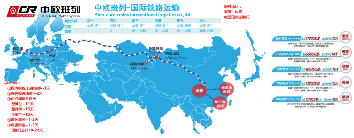
中欧班列(英语译名:China Railway Express 或 China-Europe Railway Express[1][2],简称为 CR express[3])是指按照固定车次、线路、班期和全程运行时刻开行,往来于中国与欧洲以及一带一路沿线各国的集装箱国际铁路联运班列,其中一班是从中国陜西省西安市开往欧洲的火车。[4]为加强与欧洲国家的商业贸易联络,中国政府和中国国家铁路集团与中亚和欧洲各国铁路系统协作,从起初重庆到德国的杜伊斯堡,发展到国内通达城市82个,国外通达欧亚国家的160多个城市,形成了阿拉山口、霍尔果斯、二连浩特、满洲里、绥芬河五大出境口岸,重庆、成都、西安、郑州、乌鲁木齐五大集结中心[5],开行从中国大陆到达最远伦敦、汉堡等地的国际联运列车。[3]
中欧班列也是世界上最长的货运铁路线,连接中国、哈萨克斯坦、俄罗斯、白俄罗斯、波兰、德国、法国、西班牙和伦敦。
Trans-Eurasia Logistics, AKA CHINA RAILWAY Express[1], was a joint venture between German rail company Deutsche Bahn and Russian RZhD, China Railway Corporation from China, Russian Railway Company, Russia operating container freight trains between Germany and China via Russia. The first such train arrived in Hamburg from Xiangtan on 6 October 2008, taking 17 days to make the trip.[2] Intermodal companies Polzug, Kombiverkehr, and TransContainer are also involved in the project.[3]
Container trains travel from China to Germany via the Trans-Mongolian and Trans-Siberian Railways, and then via Belarus and Poland - the route collectively known as the "Eurasian Land Bridge".[3] A break of gauge needs to be crossed when entering Mongolia from China (or Russia directly from China, if traveling via Manzhouli/Zabaykalsk), and then another one when leaving Belarus for Poland.
Trans-Eurasia Logistics operates the Yiwu - Madrid Railway line, which is the longest goods railway line in the world and connects China, Kazakhstan, Russia, Belarus, Poland, Germany, France and Spain. [4]
Trans-Eurasia Logistics est une coentreprise entre la Deutsche Bahn, la Kasachstan Temir Scholy, la China Railway Corporation et la Compagnie des chemins de fer russes, fondée en 20081
Elle permet à des trains de fret entre l'Allemagne et la Chine via la Russie, de réaliser ce trajet en dix-huit jours2.
 Economy and trade
China
China-Pakistan Economic Corridor
Pakistan
Silk road
Xinjiang Uygur Zizhiqu-XJ
Xizang Zizhiqu-XZ
Economy and trade
China
China-Pakistan Economic Corridor
Pakistan
Silk road
Xinjiang Uygur Zizhiqu-XJ
Xizang Zizhiqu-XZ

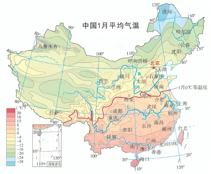
零摄氏度等温线指的是我国1月份平均气温为零摄氏度的地点所连成的线。因为温度、降水等方面的差异,在此线的南北,无论是自然条件、农业生产方式,还是地理风貌以及人们的生活习俗,都呈现出明显不同。
1月5日是今年的小寒节气。小寒,意味着已经进入一年中的寒冷季节。此时冷气积久而寒,但还没有达到最冷的程度,因而称小寒。
随着降温天气的到来,很多地方可能会下雪。不过,我国幅员辽阔,各地气候不同。冬季,当一次降水过程来临时,往往有些地方下雪,有些地方下雨。这就要说到一条无形的线——零摄氏度等温线。
在地图上将气温值相同的点连接成线,便是等温线。这里的零摄氏度,是指距地面约1.5米处的空气温度。零摄氏度等温线指的是我国1月份平均气温为零摄氏度的地点所连成的线。根据气象资料,1月份是我国每年最冷的月份,零摄氏度等温线一般是用近30年1月份的平均气温来确定的。在这条等温线以北的地区,1月份平均气温低于零摄氏度,以南则高于零摄氏度。
我国的零摄氏度等温线,大致沿秦淮一线向西延伸至青藏高原东南部边缘。它还与我国800毫米等降水量线基本一致,被认为是我国亚热带与暖温带、湿润与半湿润气候的分界线。因为温度、降水等方面的差异,在此线的南北,无论是自然条件、农业生产方式,还是地理风貌以及人们的生活习俗,都呈现出明显不同。比如,零摄氏度等温线以南的河流冬季基本不结冰,以北则一般会结冰;以南的森林多为亚热带常绿阔叶林,以北则主要为温带落叶阔叶林;以南主要种植水稻和油菜,以北则以小麦和花生为主。
那么,是不是零摄氏度等温线以北冬季就会下雪,以南就不会下雪呢?答案是不一定。
这是因为,这里的零摄氏度指的是1月份平均气温,表示一段较长时间内气候的平均状态,而一次降水过程最终的雨雪相态,与整层大气的层结状态密切相关。如果整层大气都低于零摄氏度,只有地面附近气温略高于零摄氏度,下落的雪花在地面附近来不及融化就降落到地面,就会出现地面气温高于零摄氏度却下雪的情况;如果地面上空存在一个较深厚的暖层,下落的雪花经过暖层时会完全融化成雨滴,这些雨滴来到气温低于零摄氏度的地面附近时来不及冻结就会降落到地面,这时就会出现地面气温低于零摄氏度却在下雨或冻雨的情况。
不过,需要注意的是,零摄氏度等温线以南虽然平均气温高于零摄氏度,但仍然有可能出现零摄氏度以下的日子。现实中,我们对温度的感受还会受到湿度、风速等影响,因此,还是应该及时关注当地天气预报来决定衣物的增减。
(作者为国家气象中心高级工程师,本报记者李红梅采访整理)
版权声明