
漢德百科全書 | 汉德百科全书
 Egypt
Egypt
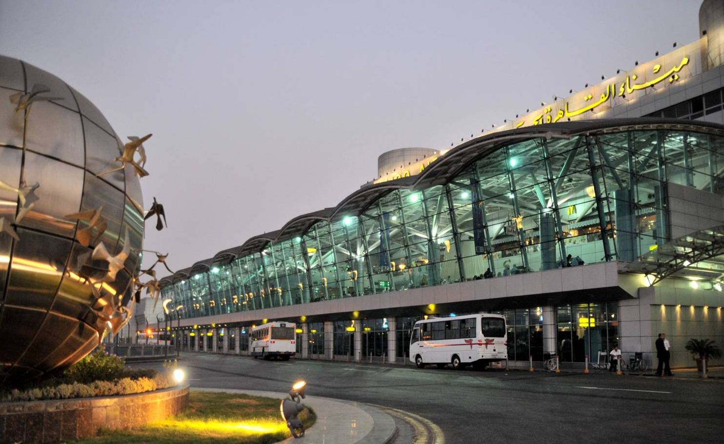
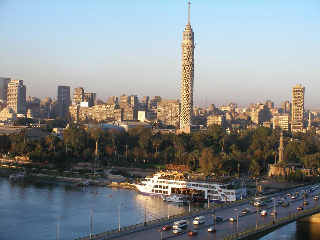

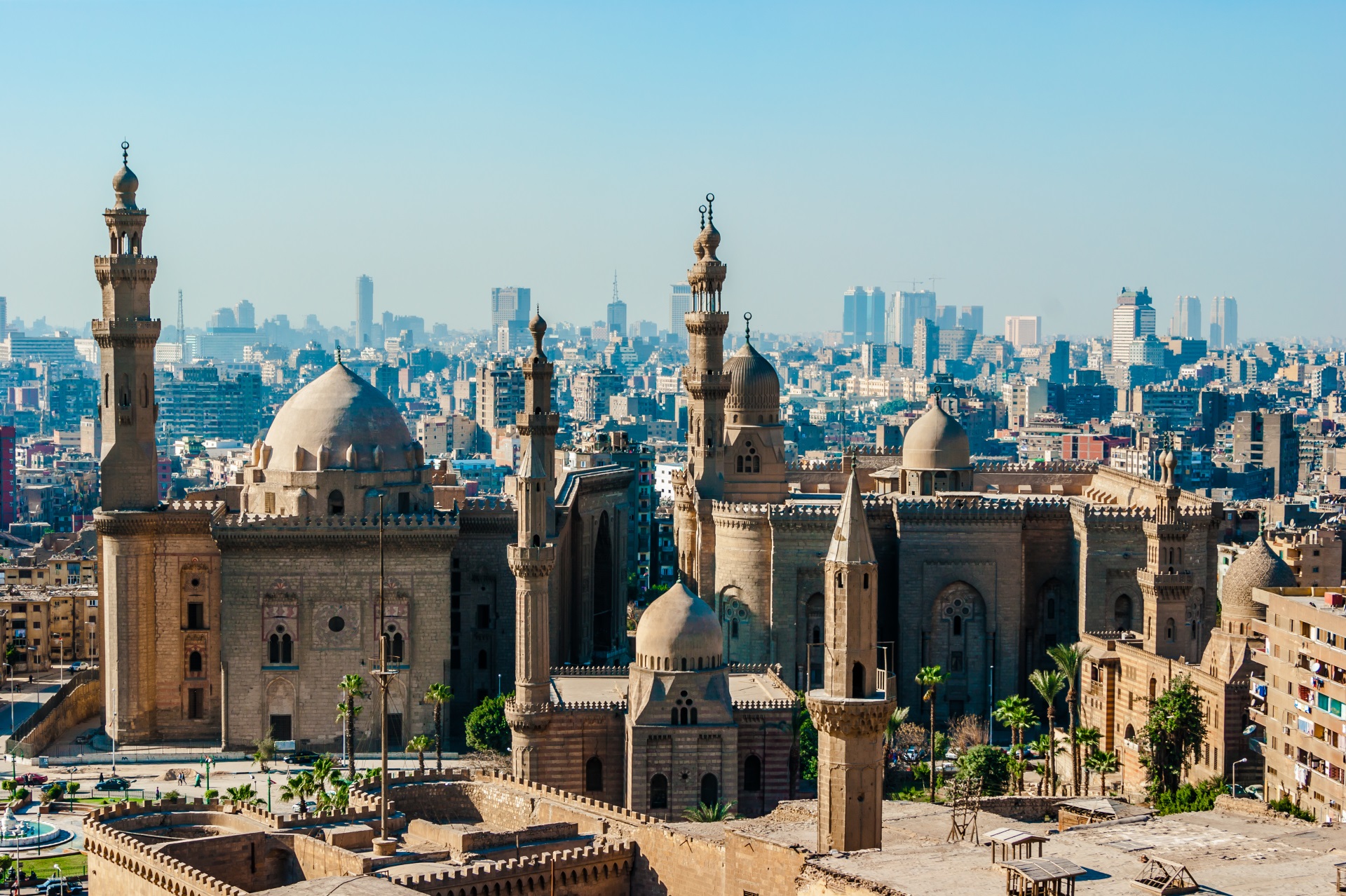

Kairo (arabisch القاهرة, DMG al-Qāhira ‚die Starke‘ oder ‚die Eroberin‘[1]) ist die Hauptstadt Ägyptens und die größte Stadt der arabischen Welt. Sie wurde 969 von dem fatimidischen Feldherrn Dschauhar as-Siqillī gegründet. Von Ägyptern wird die Stadt oftmals auch einfach mit dem Landesnamen – مصر, hocharabisch Misr, ägyptisch-arabisch Maṣr – bezeichnet.
Kairo ist das politische, wirtschaftliche und kulturelle Zentrum Ägyptens und der Arabischen Welt. Die Stadt ist Sitz der ägyptischen Regierung, des Parlaments, aller staatlichen und religiösen Zentralbehörden (Mogamma)[2] sowie zahlreicher diplomatischer Vertretungen. Kairo ist der bedeutendste Verkehrsknotenpunkt Ägyptens und besitzt zahlreiche Universitäten, Hochschulen, Theater, Museen sowie Baudenkmäler. Die Altstadt von Kairo ist ein Ensemble islamischer Baukunst und wird seit 1979 von der UNESCO als Weltkulturerbe anerkannt.[3] Die Stadt hat den Status eines Gouvernements und wird von einem Gouverneur regiert, der vom Staatspräsidenten ernannt wird.
Kairo hat 9,1 Millionen Einwohner im administrativen Stadtgebiet (2017)[4] und die Metropolregion ist mit etwa 16,2 Millionen Einwohnern (2009)[5] vor Lagos in Nigeria die größte in Afrika. In Ägypten existiert allerdings keine Meldepflicht, weswegen die angegebenen Einwohnerzahlen Hochrechnungen auf Basis der Volkszählungsergebnisse darstellen. Inoffizielle Schätzungen geben bis zu 25 Millionen Einwohner für den Großraum an, was nahezu ein Drittel der Gesamtbevölkerung Ägyptens bedeuten würde.[6]
开罗(阿拉伯语:القاهرة,罗马化:al-Qāhirah,IPA:[ælˈqɑːhɪɾɑ] (ⓘ))是埃及的首都,埃及第一大城市以及全国经济、交通和文化中心,该城市横跨尼罗河,是整个中东地区的政治、经济和商业中心。由开罗省、吉萨省和盖勒尤卜省组成,通称大开罗地区,2021年,其区域共具有2130万人口,使得大开罗成为埃及和阿拉伯世界以及非洲最大的城市,是世界第十六大都会区。[1]开罗也是世界上最古老的城市之一,自古埃及时期的孟菲斯遗址(现位于赫勒万省赫勒万)与吉萨金字塔群,再到城市从埃及阿拉伯化之后的第一个首都福斯塔特所发展起来,现在的开罗地区,阿拉伯穆斯林占多数,科普特基督徒也占有较大比例。
开罗的历史中心于1979年被授予世界遗产地位。依照全球化及世界城市研究网络(GaWC)所公布之《世界级城市》名单中,开罗被列为属于BETA+级别的国际都市[6][7]如今,开罗拥有阿拉伯世界历史最悠久、规模最大的文化、影视和音乐产业,以及世界第二古老的高等学府艾资哈尔大学。许多国际媒体、企业和组织在该市设有地区总部;阿拉伯国家联盟的行政中心也设立于此。
目前开罗人口超过1000万,城市面积超过453平方公里,另外约有950万居民居住在城市附近。与许多其他城市一样,开罗也受到空气污染和交通堵塞的困扰。开罗地铁是非洲仅有的两个地铁系统之一(另一个在阿尔及利亚的阿尔及尔) ,位列世界上最繁忙的15个地铁系统之一,每年有超过10亿乘客乘坐。2005年开罗经济位居中东第一,在2010年全球城市指数中位列全球第43位。
カイロ(アラビア語: القاهرة, al-Qāhira, アル・カーヒラ、 発音[ヘルプ/ファイル], コプト語: ⲕⲁϩⲓⲣⲏ, Kahire, 英語: Cairo)は、エジプトの首都。アラブ世界で最も人口の多い都市であり、アラブ世界及び中東を代表する世界都市の一つ。アラブ連盟の本部所在地でもあり、アラブ文化圏の中心都市でもある。
ナイル川下流河畔の交通の要衝として、中世に建設されてより現在に至るまで長い時代を通じ、イスラム世界の学術・文化・経済の中心都市であり続けた。都市自体の人口は965万6074人(2018年推定[1])、近郊を含めたグレーター・カイロ(カイロ都市圏)の人口は1,591万人で、世界第17位である[2]。『毎日新聞』によれば、カイロ都市圏の人口はその後(2016年時点)約2200万人へ増えた[3]。
アメリカのシンクタンクが2017年に発表した総合的な世界都市ランキングにおいて、世界62位の都市と評価された[4]。アフリカ大陸の都市ではヨハネスブルグに次ぐ2位である。一方、日本の民間研究所が2016年に発表した「世界の都市総合力ランキング」では世界41位と評価されており、アフリカでは1位である[5]。プライスウォーターハウスクーパースが公表した調査によると、カイロの2008年の都市GDPは1450億ドルで、世界第42位、アフリカでは第1位である[6]。
エジプトの乾燥した大地にナイル川が形作った肥沃なデルタ地帯のほぼ南端、要に位置し、河谷を流れてきたナイル川がデルタを形成する、その先端に位置する。エジプトはナイル河谷地方の上エジプトとデルタ地方の下エジプトとに古代エジプト以来、二分されており、その両者の接点にカイロは位置する。イスラム帝国が7世紀にエジプトを征服した時、征服者アラブ人の住まう軍営都市(ミスル)が置かれて以来のエジプトの首府である。
日本語でよく知られる都市名のカイロは、英語名の Cairo に由来しており、現地語であるアラビア語ではカーヒラ(القاهرة ; al-Qāhira、現代エジプト方言ではカーヘラ)という。しかし、現在でもミスル(مصر ; Miṣr、現代エジプト方言ではマスル。元々は「エジプト」を意味する呼称)という通称がよく用いられる。
カイロの中心都市はナイル川の右岸、東側に位置する。ナイルをはさんで対岸の西郊には、ピラミッドで有名なギーザの町がある。町の南は古代エジプトの中心都市の一つ、メンフィスである。
Cairo (/ˈkaɪroʊ/ KY-roh; Arabic: القاهرة, romanized: al-Qāhirah, pronounced [ælˈqɑːhɪɾɑ] ( listen)) is the capital of Egypt and the largest city in the Arab world. Its metropolitan area, with a population of over 20 million, is the largest in Africa, the Arab world, and the Middle East, and the 15th-largest in the world. Cairo is associated with ancient Egypt, as the famous Giza pyramid complex and the ancient city of Memphis are located in its geographical area. Located near the Nile Delta,[4][5] Cairo was founded in 969 AD by the Fatimid dynasty, but the land composing the present-day city was the site of ancient national capitals whose remnants remain visible in parts of Old Cairo. Cairo has long been a centre of the region's political and cultural life, and is titled "the city of a thousand minarets" for its preponderance of Islamic architecture. Cairo is considered a World City with a "Beta +" classification according to GaWC.[6]
Cairo has the oldest and largest film and music industries in the Arab world, as well as the world's second-oldest institution of higher learning, Al-Azhar University. Many international media, businesses, and organizations have regional headquarters in the city; the Arab League has had its headquarters in Cairo for most of its existence.
With a population of over 9 million[7] spread over 3,085 square kilometers (1,191 sq mi), Cairo is by far the largest city in Egypt. An additional 9.5 million inhabitants live in close proximity to the city. Cairo, like many other megacities, suffers from high levels of pollution and traffic. The Cairo Metro is one of the only two metro systems in Africa (the other being in Algiers, Algeria), and ranks amongst the fifteen busiest in the world,[8] with over 1 billion[9] annual passenger rides. The economy of Cairo was ranked first in the Middle East in 2005,[10] and 43rd globally on Foreign Policy's 2010 Global Cities Index.[11]
Le Caire (en arabe : القاهرة / al-qāhira, « La Victorieuse ») est la capitale et la plus grande ville d'Égypte. Sa population est de plus de vingt-deux millions d'habitants1, ce qui en fait la plus grande ville du Moyen-Orient et la seconde d'Afrique derrière Lagos. Elle serait également la sixième agglomération du monde en 2015. Bien qu'Al-Qāhira soit le nom officiel, en arabe égyptien, elle est plus souvent appelée Masr (le nom arabe de l'Égypte) ou el-Qahéra. Elle est située en amont du delta du Nil, sur les rives du fleuve ainsi que sur quelques îles adjacentes. Elle se trouve au nord du pays, à 178 km au sud-est d'Alexandrie et 127 km à l'ouest du canal de Suez. Les habitants du Caire sont appelés les Cairotes2.
La région de Memphis a longtemps été un centre majeur de l'Égypte antique. Vers le IVe siècle, les Romains établirent la cité-forteresse de Babylone le long de la rive est du Nil. Dès la conquête de l'Égypte par les Arabes en 641, Al-Fustat devient un centre administratif et religieux. Les Fatimides et leur troupes composées de Berbères kotamas d'Algérie fondent le noyau urbain actuel, alors nommé Al-Mansûriyyah, pour en faire leur nouvelle capitale. Située sur la route des épices entre l'Europe et l'Asie, la ville connaît une longue période de prospérité : vers 1340, la population du Caire atteint un demi-million d'habitants, ce qui en faisait déjà l'une des plus grandes villes du monde arabe. La peste noire frappe toutefois la cité plus de cinquante fois entre 1348 et 1517. Sous l'Empire ottoman, la ville perd son statut de capitale au profit d'Istanbul. Devenue capitale de l'Égypte moderne en 1922, elle connaît une forte poussée démographique et devient le centre politique et économique de l'Afrique du Nord et du monde arabe, abritant aujourd'hui un grand nombre de compagnies et d'organisations multinationales, dont la Ligue arabe.
La ville actuelle présente une grande diversité urbanistique et architecturale. Le centre historique de la ville comprend le Vieux Caire (quartier copte où se trouvent la forteresse de Babylone et le musée copte) ainsi que le quartier islamique, classé au patrimoine mondial de l'humanité, où se trouvent la citadelle de Saladin et le grand souk (Khân al-Khalili). Le Caire compte également de nombreuses mosquées, dont la mosquée Al-Azhar qui abrite également l'une des plus anciennes universités au monde. Centre névralgique de la ville moderne, la place Tahrir est devenue l'emblème de la révolution égyptienne de 2011. À l'ouest se trouve la ville de Gizeh et la nécropole antique de Memphis, avec ses trois grandes pyramides, dont la pyramide de Khéops. Au sud se trouve le site de l'antique ville égyptienne de Memphis.
Il Cairo (in arabo: القاهرة, al-Qāhira) è la capitale dell'Egitto, che conta più di 10 milioni di abitanti nel governatorato omonimo e circa 20,4 milioni[3] di residenti nell'area metropolitana adiacente, creando la mega metropoli cariota, la Grande Cairo[4] (in arabo: القاهرة الكبرة, Al-Qāhira al-Qobra): essa è la città africana più popolosa dopo la città nigeriana Lagos. La città è stata fondata sul Nilo.
Nonostante al-Qāhira sia il nome ufficiale della città, il Cairo viene chiamato semplicemente con il nome Egitto, Miṣr (in arabo: مصر) pronunciato Masr in dialetto locale.
El Cairo (en árabe, القاهرة Al-Qāhira 'la fuerte', 'la victoriosa') es la capital de Egipto y de su gobernación (muhafazah o provincia). Es la mayor ciudad del mundo árabe, de Oriente Próximo y de África, y los egipcios la denominan a menudo sencillamente con el nombre del país, مصر, pronunciado en árabe culto Misr y dialecto egipcio Masr.
Su área metropolitana incluye una población aproximada de unos 16 millones de habitantes,3 convirtiendo a El Cairo en la undécima urbe más poblada del mundo Es, también, el área metropolitana más poblada de todo el continente africano.4 Es conocida por los egipcios como la "madre de todas ciudades" y la "ciudad de los mil minaretes".5 También figura junto con Teherán, Estambul, Karachi, Damasco, Bagdad, Kuala Lumpur, Alejandría, La Meca, Casablanca y Yakarta como una de las urbes más importantes del mundo islámico. Fue fundada en el año 116 d. C., en lo que hoy en día se conoce como Viejo Cairo, cuando los romanos reconstruyeron una antigua fortaleza persa junto al río Nilo. Antes de su fundación, Menfis u otras ciudades eran la capital del imperio faraónico. El nombre actual se debe a los fatimíes, que bautizaron la ciudad con el nombre, Al-Qahira. Tras diversas invasiones como la de los mamelucos, otomanos, Napoleón y los británicos, El Cairo se convirtió en capital soberana en 1952.5
El Cairo está ubicada en las riberas e islas del río Nilo, al sur del delta. Hacia el sudoeste se encuentra la ciudad de Guiza y la antigua necrópolis de Menfis, con la meseta de Guiza y sus monumentales pirámides, como la Gran Pirámide. Al sur se encuentra el lugar donde se edificó la antigua ciudad de Menfis.
Каи́р (араб. القاهرة, Эль-Кахира[3] — «победоносная», копт. ⲕⲁϣⲣⲱⲙⲓ Кашроми[4] — «сокрушитель людей») — столица Арабской Республики Египет. Крупнейший город Ближнего Востока и третий по величине город Африки, после Лагоса и Киншасы (без учёта агломерации). Египтяне его часто называют مصر — Маср[5][6], то есть тем же словом, что и всю страну Египет.

 Medical, Pharmaceutical, Rehabilitation
 Medical colleges/Research Institute
 Nobel prize
 Nobel Prize in Literature
 Nobel prize
 Nobel Peace Prize
 Nobel prize
 University/Institute
 Sinology




Der Luxor-Tempel (altägyptisch Ipet-reset) ist eine Tempelanlage im heutigen Luxor in Ägypten. Er wurde zur Zeit des Neuen Reichs errichtet und südlicher Harem des Amun von Karnak genannt. Er war dem Gott Amun, seiner Gemahlin Mut und ihrem gemeinsamen Sohn, dem Mondgott Chons, geweiht.
Der Tempel steht seit 1979 zusammen mit dem Karnak-Tempel und der thebanischen Nekropole auf der Weltkulturerbeliste der UNESCO.[1]
Aus wiederverwendetem Baumaterial wird geschlossen, dass hier bereits während der 12. Dynastie ein Heiligtum errichtet worden war. Unter Pharao Thutmosis III. wurde die Stationskapelle im ersten Hof gebaut.
An der vermeintlichen Stelle eines Heiligtums aus der 12. Dynastie ließ Amenophis III. durch seinen Baumeister Amenophis (Sohn des Hapu) den heutigen südlichen Teil des Tempels mit Sanktuar, Säulenhalle und dem zweiten Hof errichten. Auch der Säulengang wurde zu seiner Regierungszeit begonnen. Unter Amenophis IV. (Echnaton) wurde der Tempel geschlossen, der Name des Gottes Amun getilgt und der König errichtete in der Nähe ein Atonheiligtum. Tutanchamun baute am Säulensaal weiter, der durch Haremhab fertiggestellt wurde.
Ramses II. ließ den ersten Hof samt dem mächtigen Pylon sowie Statuen und Obelisken ausführen. Nektanebos I. gestaltete den Vorhof.
Alexander der Große ließ das Sanktuar umbauen. Statt der vier Säulen, die das Dach trugen, wurde eine Kapelle errichtet. In der Römerzeit wurde die Tempelanlage in eine Festung integriert. In den ersten nachchristlichen Jahrhunderten wurden vier Kirchen auf dem Gelände errichtet.
卢克索神庙(Luxor Temple)位于埃及卢克索的尼罗河东岸,即古埃及新王国时期的首都底比斯,大约建于公元前十四世纪。
通过神庙中重新被使用的建筑材料可以推导出在埃及第十二王朝时这里就已经有一座神庙了。法老图特摩斯三世在这里建造了新神庙的第一个部分。
阿蒙霍特普三世命令他的建筑师阿蒙霍特普在今天神庙的南部建造了圣殿、柱殿和第二个内院。柱廊也是他统治时期开始建造的。阿蒙霍特普四世时神庙被关闭,阿蒙的名字被涂抹,在神庙的边缘建造了一座阿頓的神庙。图坦卡蒙继续了神庙的建造,哈伦海布完成了柱殿。
拉美西斯二世建造了第一院、带有雕像的大门和方尖塔。内克塔内布一世建造了大门前的院。
亚历山大大帝下令改造圣殿,将支撑屋顶的四根柱子改为一座小堂。在罗马帝国时期整个神庙被结合到一座要塞中。公元后一开始的几个世纪里整个神庙内还建造了四座教堂。
ルクソール神殿(ルクソールしんでん、英語: Luxor Temple)は、エジプトのルクソール(古代のテーベ)東岸にある古代エジプト時代の神殿複合体である。もともとカルナック神殿の中心を形成するアメン大神殿の付属神殿として[2]、エジプト第18王朝(紀元前1550-1295年頃[3])ファラオのアメンホテプ3世(紀元前1390-1352年頃[3])によって中心部分が建立された[1]。
神殿の後方には、アメンホテプ3世およびアレクサンドロス3世(紀元前332-323年[3])によって構築された祠堂がある[4][5]。ローマ時代には、神殿およびその周辺は軍の要塞となり、その領域はローマ政府の基地であった[6]。
アメン大神殿とはスフィンクスの参道で結ばれていた。神殿入口となる第1塔門の前には1対のラムセス2世(紀元前1279-1213年頃[3])の坐像、その手前にはオベリスク(高さ25メートル[7])が1本立っている[4]。オベリスクは本来左右2本あったが、右側の1本(高さ22.55メートル[7])は1819年[4]、フランスに贈られてパリに運ばれ、現在コンコルド広場にある[8]。
Luxor Temple is a large Ancient Egyptian temple complex located on the east bank of the Nile River in the city today known as Luxor (ancient Thebes) and was constructed approximately 1400 BCE. In the Egyptian language it is known as ipet resyt, "the southern sanctuary". In Luxor there are several great temples on the east and west banks. Four of the major mortuary temples visited by early travelers and tourists include the Temple of Seti I at Gurnah, the Temple of Hatshepsut at Deir el Bahri, the Temple of Ramesses II (a.k.a. Ramesseum), and the Temple of Ramesses III at Medinet Habu; and the two primary cults temples on the east bank are known as the Karnak and Luxor.[1] Unlike the other temples in Thebes, Luxor temple is not dedicated to a cult god or a deified version of the king in death. Instead Luxor temple is dedicated to the rejuvenation of kingship; it may have been where many of the kings of Egypt were crowned in reality or conceptually (as in the case of Alexander the Great who claimed he was crowned at Luxor but may never have traveled south of Memphis, near modern Cairo.)
To the rear of the temple are chapels built by Amenhotep III of the 18th Dynasty, and Alexander. Other parts of the temple were built by Tutankhamun and Ramesses II. During the Roman era, the temple and its surroundings were a legionary fortress and the home of the Roman government in the area.
Le temple d'Amon à Louxor ou Opet du sud1 est un temple égyptien voué au culte d'Amon. Situé au cœur de l’ancienne Thèbes, il fut construit pour l’essentiel sous les XVIIIe et XIXe dynasties. Il était consacré au dieu dynastique Amon sous ses deux aspects d’Amon-Rê céleste et d'Amon-Min (divinité ithyphallique). Les parties les plus anciennes actuellement visibles remontent à Amenhotep III et à Ramsès II. Par la suite, de nouveaux éléments furent ajoutés par Chabaka, Nectanébo Ier et les Lagides. À l’époque romaine, le temple fut partiellement transformé en camp militaire. L’édifice, l’un des mieux préservés du Nouvel Empire, a gardé de nombreuses structures en élévation. Outre le grand pylône, le visiteur peut ainsi traverser deux grandes cours à péristyle et la colonnade monumentale qui relie ces deux cours. Le sanctuaire proprement dit, résidence de l'Amon d'Opet, de même que les salles qui précèdent ont conservé une bonne partie de leur couverture en dalles.
Il tempio di Luxor è un grande complesso templare egiziano situato sulla riva orientale del Nilo nella città di Luxor (antica Tebe).
Noto nella lingua egizia come ipet resyt, o "harem meridionale", il tempio era dedicato a Amon; durante il Nuovo Regno fu il centro della festa annuale di Opet, nella quale una statua di Amon era trasferita lungo il Nilo dal vicino Grande tempio di Amon noto anche come Tempio di Karnak Ipet-sut[1] per il rito di fertilità.
El templo de Lúxor, situado en el corazón de la antigua Tebas, fue construido esencialmente bajo las dinastías XVIII y XIX egipcias. Estaba consagrado al dios Amón bajo sus dos aspectos de Amón-Ra (Ra, era considerado el dios del cielo, dios del Sol y del origen de la vida en la mitología egipcia). Las partes más antiguas actualmente visibles remontan a Amenhotep III y a Ramsés II. Seguidamente, nuevos elementos fueron añadidos por Shabako, Nectanebo I y la dinastía ptolemaica. En época romana, el templo fue parcialmente transformado en campo militar. El edificio, uno de los mejores conservados del Nuevo Imperio egipcio, aún mantiene numerosas estructuras. Además del gran pilono, el visitante puede también atravesar dos grandes peristilos y la columnata monumental que enlaza estos dos patios. El santuario propiamente dicho, residencia del Amón de Opet, al igual que las salas que conservan una gran parte de sus baldosas.
Forma parte del conjunto denominado Antigua Tebas con sus necrópolis, declarado Patrimonio de la Humanidad por la Unesco en 1979.
Луксорский храм — развалины центрального храма Амона-Ра, на правом берегу Нила, в южной части Фив, в пределах современного города Луксор.
Храм богов Амона, Мут и Хонсу представляет собой наиболее полное воплощение архитектурных особенностей Нового царства (XVI—XI вв. до н. э.) Его отличают грандиозность замысла, монументальность и торжественность деталей, большое количество колонн.
Храм ориентирован с северо-запада на юго-восток. Для соответствия с пилонами стоявшего в получасовом расстоянии к северу Карнака, с которым он был соединён мощёной аллеей сфинксов, северный пилон его уклонен несколько к востоку от общей оси.
Древнейшая часть — святая святых, с примыкающими залами, украшенными монументальными рельефами и надписями — основана при Аменхотепе III; первые цари XIX династии прибавили к югу двор с 74 колоннами, перемежающимися статуями фараонов. Рамсес Великий пристроил северный перистиль и пилон и изобразил на внешней стороне последнего свои подвиги в войне с хеттами; здесь же начертан так называемый «эпос Пентаура».
У северного входа Луксорского храма — четыре колосса-монолита и два обелиска, из которых один перевезен в 1830-е гг. в Париж, на площадь Согласия. Длина сооружения от входа до самой северной стены — 260 метров.


Die Muhammad-Ali-Moschee (arabisch مسجد محمد علي Masdschid Muhammad ʿAlī ‚Moschee des Mohammed Ali‘), manchmal auch als Alabastermoschee bezeichnet, ist eine der großen Moscheen in Kairo. Sie wurde im Auftrag von Pascha Muhammad Ali in den Jahren 1824 bis 1884 im osmanischen Stil mit barocken Elementen erbaut. Verantwortlich für den Bau zeichnete der Grieche Boşnak Yusuf aus Istanbul, der sich stilistisch an der dortigen Neuen Moschee (türk. Yeni Cami) orientierte.
穆罕默德·阿里清真寺(阿拉伯语:مسجد محمد علي Masjid Muhammad ʿAlī 'Mosque of Mohammed Ali'),有时也被称为阿拉巴斯清真寺,是开罗最大的清真寺之一。该清真寺由帕夏-穆罕默德-阿里委托建造,建于 1824 年至 1884 年之间,采用了带有巴洛克元素的奥斯曼风格。来自伊斯坦布尔的希腊人博什纳克-尤素福负责建造,他的风格是以当地的新清真寺(土耳其语:Yeni Cami)为蓝本。
 Transport and traffic
 Companies
 Architecture
 International cities
 History
 Sport
Sport
 Hand in Hand
 Religion
 World Heritage
 Civilization
 Ancient Egypt
