漢德百科全書 | 汉德百科全书

       
Chinese — German
Catalog Geography

Zhongba (Ort in Tibet)
This image, video or audio may be copyrighted. It is used for educational purposes only. If you find it, please notify us byand we will remove it immediately.
Chongqing-Reisekarte
http://www.net4info.de/photos/cpg/albums/userpics/10002/Zhong20Qing20Lu20You20Di20Tu20.png
This image, video or audio may be copyrighted. It is used for educational purposes only. If you find it, please notify us byand we will remove it immediately.
Touristenkarte von Chongqing

This image, video or audio may be copyrighted. It is used for educational purposes only. If you find it, please notify us byand we will remove it immediately.
Chongqing
重庆是重庆市地跨青藏高原同长江中下游平原的过渡地带,地处中国内陆西南部,长江上游地区,渝东接湖北、东南接湖南,渝南接贵州,渝西接四川,渝北接陕西,辖区东西长约470公里,南北宽约450公里,辖区总面积8.2403万平方公里。重庆是中国面积最大的直辖市,是一个集大城市、大农村、大山区、大库区为一体的组团式城市,其中主城区建成面积为877.78平方公里。全市面积8.24万平方千米, 是世界上市域人口最多的城市。重庆市现辖26个市辖区、8个县、4个自治县;1031个乡级行政区,包括625镇,147乡,14民族乡,245街道。 市辖区:万州区、涪陵区、渝中区、大渡口区、江北区、沙坪坝区、九龙坡区、南岸区、北碚区、綦江区、大足区、渝北区、巴南区、黔江区、长寿区、江津区、合川区、永川区、南川区、璧山区、铜梁区、潼南区、荣昌区、开州区、梁平区、武隆区 县:城口县、丰都县、垫江县、忠县、云阳县、奉节县、巫山县、巫溪县 自治县:石柱土家族自治县、秀山土家族苗族自治县、酉阳土家族苗族自治县、彭水苗族土家族自治县
/assets/contentimages/Zhong20Qing20Shi20.png
This image, video or audio may be copyrighted. It is used for educational purposes only. If you find it, please notify us byand we will remove it immediately.
Karte der Verwaltungsbezirke von Chongqing

This image, video or audio may be copyrighted. It is used for educational purposes only. If you find it, please notify us byand we will remove it immediately.
Zhouqu (Ort in Gansu)
This image, video or audio may be copyrighted. It is used for educational purposes only. If you find it, please notify us byand we will remove it immediately.
Zhoushan-Inseln
/assets/contentimages/Zhou20Shan20Qun20Dao20~0.jpg
This image, video or audio may be copyrighted. It is used for educational purposes only. If you find it, please notify us byand we will remove it immediately.
Zhoushan Shi
舟山市是中华人民共和国浙江省下辖的地级市,位于浙江省东北部,长江三角洲城市群东南部,其陆地行政范围含且仅含2085个海岛组成的舟山群岛(其中有居民海岛141个;含礁则共4696个岛礁)。群岛地处长江口南侧,杭州湾外缘的东海海域,是天台山脉的入海馀脉。市名与群岛名均来源于历代行政中心所在地、群岛第一大岛——舟山岛,该岛也是中国第三大岛(实际控制,宣称为第四大岛)。除1440km²的岛礁陆地外,舟山市同时辖有2.08万km²的海域,中国最大的海洋渔场舟山渔场处于其中。舟山与宁波的大小港区组成了世界第一大港——宁波—舟山港,此外舟山港还是世界第五大加油港。舟山市现辖2个市辖区、2个县。 市辖区:定海区、普陀区 县:岱山县、嵊泗县

This image, video or audio may be copyrighted. It is used for educational purposes only. If you find it, please notify us byand we will remove it immediately.
Zhoucun (Gegend in Shandong)
This image, video or audio may be copyrighted. It is used for educational purposes only. If you find it, please notify us byand we will remove it immediately.
Zhoukou (Bezirk in Henan)
This image, video or audio may be copyrighted. It is used for educational purposes only. If you find it, please notify us byand we will remove it immediately.
Zhouning (Ort in Fujian)
This image, video or audio may be copyrighted. It is used for educational purposes only. If you find it, please notify us byand we will remove it immediately.
Zhoushan Inseln


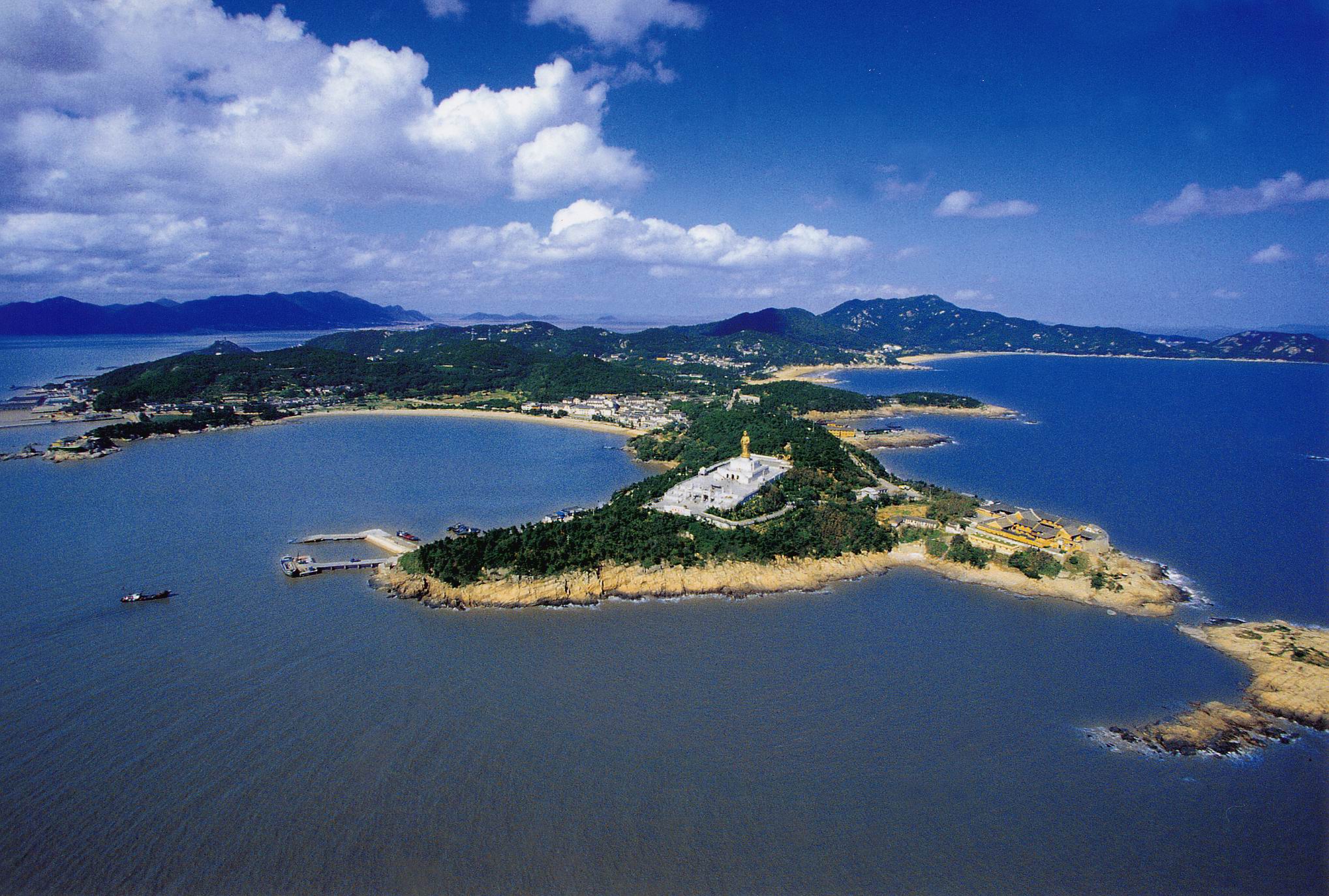
Chinas größte Küsteninseln. Gefunden im Süden der Yangtze Flußmündung, Hangzhou Bucht in der Zhejiang Provinz, östlich des Nordwassers. Alte imperiale Seegassen.

Große Verbreitung der Zhoushan Inseln Reefs, dort sind grosse und kleine Insel 1.339. Meine Insel ist bis ungefähr 20% der Gesamtmenge, gehören Zhoushan Stadt in der Zhejiang Provinz, Daishan Grafschaft, Shensi Grafschaft gleichwertig; Verteilung von 22.000 quadratischen Kilometern Sebereichen, Landbereich von 1.371 quadratischen Kilometern. Eine quadratischen Kilometer der Insel über 58, ein ganzes Gebiet der Inseln von 96.9% erklärend. Die vollständige Inselgruppe ist der Nordosten zu aufeinanderfolgendem. Südliche Oshima höhere Aufzüge, mit intensivem, die meisten Nordinseln, niedrig-liegend, wurden zerstreut; Hauptinseln von Zhoushan Insel, Daishan Insel, Zhujiajian Insel, Liuheng Insel, Jintang Insel, das größte von welcher Zhoushan Insel, mit einem Bereich von 502 quadratischen Kilometern, für unsere vierte größte Insel.

Vor mehr als 5.000 Jahren, hat Menschheit die Zhoushan Inseln hat multipliziert. Zapfen fing an, die Grafschaft zu errichten, ist gewesen 1.200 Jahre Geschichte. Lokalisierte Hügelbereich 1950 die Wochen, im Januar 1987 hergestellt der Stadt. Zhoushan bekannt als die Kuril Inseln zum guten Namen einer Stadt. Zhoushan Insel-Küstenweg ist die unvermeidliche Weise zu gehen. Jetzt hat die schnelle Hafenanlage der Zhoushan Inseln gewordenes Shanghai, Ningbo watercraft Zwischenzeitssatelliten Kong.

Zhoushan Inseln in den östlichen Zhejiang Dachspitzebergen zum Meer neben der Verlängerung. In 10000-8 Jahren vor, wegen des Meeresspiegelaufstieg Willensnur versenkten Berges bildete die Inselgruppe. Inseln des höchsten Punktes in der Konfrontation zwischen dem Pfirsich-Blüte Insel-Berg, Aufzug 544.4 Meter. Inseln gehören den gesamten hügeligen Landschaftsarten. Eustacy, langfristige Abnutzung der Wellen, die Seinseln zum Entwicklung Stadium, die Höhle. Können Meßinstrument-hohe Terrassen der Zhoushan Insel 10 Seeüberall gesehen werden, das Meßinstrument-hohe Stadium 30, um freier zu sein. Einfassung Putuo Insel Chaoyindongdoushu Seehöhlen. Wie eine Haupttendenz wie Porters große Menge der verborgenen Absetzungzone der Sedimentabbau Inseln, einige Inseln verbinden. Anordnung der Inselansammlung Ebene. Zhoushan Insel, Zhujiajian, Daishan Insel liegen an der Expansion der Ebene gebildet von Kenzo.

This image, video or audio may be copyrighted. It is used for educational purposes only. If you find it, please notify us byand we will remove it immediately.