
Deutsch-Chinesische Enzyklopädie, 德汉百科
 Tajikistan
 *Changjiang|Yangtze River
 *Changjiang|Yangtze River
 *Yellow river
 *Yellow river

 Afghanistan
 Bhutan
 China
China
 Gansu Sheng-GS
 India
India
 Kyrgyzstan
 Nepal
Nepal
 Pakistan
 Qinghai Sheng-QH
 Sichuan Sheng-SC
 Tajikistan
 Xinjiang Uygur Zizhiqu-XJ
 Xizang Zizhiqu-XZ
 Yunnan Sheng-YN
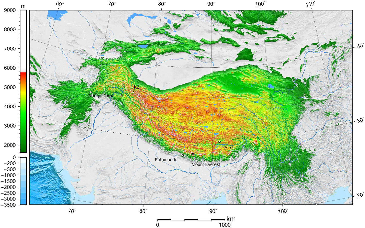
青藏高原,是东亚一个高原地区,它是世界上最高的高原,平均海拔高度5900米(5800~6000米),面积250万平方公里,有“世界屋脊”,“雪域高原”,和“第三极”之称。它是在中亚[1][2][3][4]和西亚[5][6][7][8]的一个巨大的高原,大部分在中国西部的西藏自治区和青海省,以及在印度查谟-克什米尔邦拉达克的一部分。 它从南向北延伸约1,000千米(620英里),从东到西延伸约2,500千米(1,600英里)。中国境内之青藏高原,占全中国23%面积,位于北纬25°-40°和东经74°-104°之间。
高原边界,东为横断山脉,南、西为喜马拉雅山脉,北为昆仑山脉。涵盖国境有中国西藏自治区、青海省全境、新疆维吾尔自治区、甘肃省、四川省、云南省部分,以及不丹、尼泊尔、印度的拉达克等地。
Das geographisch definierte Hochland von Tibet bzw. offiziell Qinghai-Tibet-Hochebene (chinesisch 青藏高原, Pinyin Qīng-Zàng gāoyuán), auch Hochasien, umfasst nicht nur den gesamten Lebensraum tibetisch-sprachiger Völkerschaften, das noch kleinere historische Tibet oder das heutige Autonome Gebiet Tibet (AGT) der Volksrepublik China, sondern auch die es eingrenzenden Hochgebirge Himalaya, Kunlun Shan, Qilian Shan usw.
Nachdem die Hochebene im frühen Miozän entstand, erreichte es die heutige Höhe vor etwa acht Millionen Jahren. Mit der Zeit schürften Erosion und Wetter Täler und bildeten Steilwände und Klippen.
Das Hochland, das etwa 4000 bis 5500 Meter Höhe über dem Meeresspiegel liegt und rund 2 Millionen km² groß ist, wird im Norden von den Wüsten des Tarimbeckens und Qaidam-Beckens begrenzt, im Süden und Westen von den Gebirgen Himalaya, Karakorum und Pamir. Obwohl der höchste Gipfel nur 7010 Meter hoch ist, ist die Ebene das höchste Plateau der Welt. Hier finden sich zahlreiche Salzseen in den Schluchten wie den Tilicho Lake, der auf 4920 Metern liegt und damit einer der höchstgelegenen Seen der Welt ist, des Weiteren weite Steppen, dichte Wälder und Wüsten. Diese Naturräume bieten vielen Tieren – darunter auch gefährdeten – Schutz, so etwa Yaks, Saigaantilopen, Asiatischen Schwarzbären, Schafen und Kiangs.
Zum Hochland von Tibet zählen demgemäß auch die Gebiete Ladakh, Zanskar, Lahaul und Spiti, Nord-Sikkim und weite Teile von Arunachal Pradesh in Nordindien, wie auch große Teile Bhutans und der Norden Nepals. Innerhalb der Volksrepublik China sind neben dem Autonomen Gebiet Tibet auch die gesamte Provinz Qinghai, der Südwesten von Gansu sowie Randbereiche des Nordwestens dieser Provinz, der Westen Sichuans und der Nordwesten Yunnans Teil des Hochlands, während das Aksai Chin im fernen Westen des Plateaus im Autonomen Gebiet Xinjiang in den Pamir überleitet.
チベット高原(チベットこうげん、中国語: 青藏高原、雪域高原)はユーラシア大陸の中央部に広がる世界最大級の高原。チベットの領域とほぼ等しい。 東西約2,000キロメートル、南北約1,200キロメートル、面積約250万平方キロメートル(日本の国土面積の約6倍)。高度は3,500から5,500メートル、平均4,500メートル。
南境にはヒマラヤ山脈、西境にはカラコルム山脈、北境には崑崙山脈・阿爾金山脈・祁連山脈、東境には横断山脈(邛崍山脈)が走り、7,000から8,000メートル級の高峰が連なる。東北部には面積20万平方キロメートルのツァイダム盆地やティショルギャルモ湖(青海湖)がある。
20世紀後半からこの高原の大部分を領有している中華人民共和国は西蔵・青海などの諸地方に区分して、両地方の略称「青」「藏」をあわせた青藏高原(拼音: せいぞうこうげん)としている。この高原は現在の中国領土の約23パーセントの面積を占めている。
また、チベット亡命政府が領有を主張している地域ともほぼ一致する。
The Tibetan Plateau (Tibetan: བོད་ས་མཐོ།, Wylie: bod sa mtho), also known in China as the Qinghai–Tibet Plateau[1] or the Qing–Zang Plateau[2] (Chinese: 青藏高原; pinyin: Qīng–Zàng Gāoyuán) or Himalayan Plateau, is a vast elevated plateau in Central Asia[3][4][5][6] and East Asia,[7][8][9][10] covering most of the Tibet Autonomous Region and Qinghai in western China, as well as Ladakh (Jammu and Kashmir) and Lahaul & Spiti (Himachal Pradesh) in India. It stretches approximately 1,000 kilometres (620 mi) north to south and 2,500 kilometres (1,600 mi) east to west. With an average elevation exceeding 4,500 metres (14,800 ft), the Tibetan Plateau is sometimes called "the Roof of the World" because it stands over 3 miles (4.8 km) above sea level and is surrounded by imposing mountain ranges that harbor the world's two highest summits, Mount Everest and K2, and is the world's highest and largest plateau, with an area of 2,500,000 square kilometres (970,000 sq mi) (about five times the size of Metropolitan France).[11] Sometimes termed the Third Pole, the Tibetan Plateau contains the headwaters of the drainage basins of most of the streams in surrounding regions. Its tens of thousands of glaciers and other geographical and ecological features serve as a "water tower" storing water and maintaining flow. The impact of global warming on the Tibetan Plateau is of intense scientific interest.[12][13][14][15]
Le plateau tibétain est un vaste ensemble de plateaux situé en Asie centrale, au nord de l'Himalaya, dont la majeure partie est située en République populaire de Chine et quelques parties le sont en Birmanie, au Bhoutan, au Népal et en Inde. Il a été créé par la collision des plaques indienne et eurasienne qui ont pris en étau les plaques de Qiantang et de Lhassa au cours du Cénozoïque. Constituant une des plus grandes structures topographiques de la Terre, il a d'importants effets climatiques régionaux (aridité du plateau lui-même, mousson) et mondiaux (circulation atmosphérique mondiale). Le nord-ouest du plateau, le Changtang, en est la région la plus élevée. D'une altitude dépassant souvent 5 000 m, il est pratiquement inhabité.
L'altopiano del Tibet (བོད་ས་མཐོ་) è un vasto ed elevato altopiano dell'Asia centrale che copre la maggior parte della regione autonoma del Tibet e della provincia del Qinghai in Cina e parte del Ladakh, nel Kashmir indiano.[1][2][3][4]
Occupa una superficie che si estende per 2.500 km di lunghezza e per 1.000 di larghezza, ad un'altitudine media di oltre 4.500 m s.l.m.[5][6][7] Talvolta chiamato il tetto del mondo, è l'altopiano più alto e più vasto del mondo, con una superficie di 1,2 milioni di chilometri quadrati (circa due volte la dimensione del Texas o della Francia, più di quattro volte l'Italia).[8]
L'altopiano tibetano è circondato da alte catene montuose: è delimitato a nord-ovest dai monti Kunlun che lo separano dal bacino del Tarim, e a nord-est dalla catena dei Qilian Shan che lo separa dal Corridoio di Hexi e dal deserto del Gobi. I suoi confini meridionali sono disegnati dalla valle del fiume Brahmaputra (Yǎlǔ Zàngbù Jiāng) che corre lungo la base dell'Himalaya. A occidente l'altopiano è abbracciato dalla robusta catena del Karakoram nel Kashmir settentrionale. A est e sud-est l'altopiano cede il passo alle gole boscose dei fiumi Salween, Mekong, Fiume Azzurro, alle regioni occidentali del Sichuan e sud-occidentali del Qinghai.
La meseta del Tíbet, también conocida como la meseta Tibetana-Qinghai, es una extensa y elevada meseta de Asia oriental que ocupa gran parte de la Región Autónoma del Tíbet y de la provincia de Qinghai, en la República Popular China, y de la región india de Ladakh, en Cachemira. Ocupa un área rectangular aproximada de 1.000 km de ancho por 2.500 km de largo, y tiene una elevación media de 4.500 metros. Es llamada "el techo del mundo", pues es la meseta más alta y grande del mundo, con un área de 2,5 millones de kilómetros cuadrados de extensión (cerca del tamaño de la República Argentina y cuatro veces el tamaño de Texas o Francia)
La meseta tibetana está rodeada por cadenas de montañas elevadas.1 Limita al noroeste con la cordillera Kunlun, que la separa de la cuenca del Tarim, y al noreste con las montañas Qilian, que separa la meseta del desierto de Gobi. La meseta limita al sur con el valle del río Yarlung Tsangpo, que fluye a lo largo del pie del Himalaya, y por la extensa Llanura indogangética. Al este y sureste, la meseta da paso a la geografía arbolada y abrupta de montaña de los nacimientos de los ríos Saluin, Mekong y Yangtsé, en la zona occidental de Sichuan. En el oeste está rodeada por la curva de la abrupta cordillera de Karakoram del norte de Cachemira.
Тибе́тское наго́рье — самое большое по площади и высочайшее нагорье мира[1],имеющее площадь около 2,5 млн кв. км, среднюю высоту 4877 м. Протяжённость с запада на восток 2500 км, с юга на север 1000 км[2]. Очень разнообразно по рельефу, растительности и животному миру. Посещаемости туристов способствует известность Тибета как обители буддийских монахов, святых (махатм).
Территория богата полезными ископаемыми, включая золото, что по некоторым сведениям и спровоцировало захват Тибета Китайской Народной Республикой в 1951 году, и последущее разграбление богатств страны[3] (Китай также получил контроль над источниками почти всех больших рек Азии).
Нагорье с севера ограничено хребтом Куньлунь, с северо-востока — системой хребтов Циляньшань, отделяющим его от пустыни Гоби. В Тибетском нагорье начинаются крупнейшие реки Инд, Брахмапутра, Салуин, Меконг, Янцзы, Хуанхэ. На западе нагорье граничит с хребтами Памира, на востоке с Сино-Тибетскими горами[4].

Der Karakorum ist ein bis zu 8611 m hohes Gebirge in Südasien. Er trägt mit dem K2 den zweithöchsten Berg der Erde sowie mit Broad Peak (8051 m), Gasherbrum I („Hidden Peak“, 8080 m) und Gasherbrum II (8034 m) drei weitere Achttausender. Außerdem befinden sich hier 63 eigenständige Siebentausender und etliche Nebengipfel.[1] Der Karakorum erstreckt sich über den Norden Pakistans, Indiens und den Westen Chinas, Teile des Grenzverlaufs sind umstritten. Der Indus und dessen Zufluss Shyok grenzen den Karakorum von der Himalaya-Hauptkette im Südosten ab.
Das Gebirge hat eine Ausdehnung von etwa 700 Kilometern Länge und eine Breite von 100 bis 150 Kilometern und erstreckt sich in einem leichten Bogen von Nordwest nach Südost.[2]
Der Karakorum wird als höchstes Gebirge der Welt bezeichnet. Der höchste Berg der Erde, der Mount Everest, liegt zwar nicht im Karakorum, aber mehr als die Hälfte der Gebirgsfläche liegt oberhalb von 5000 Metern.[3] Das Tibetische Hochland liegt auf einer Höhe von 4500 bis 5000 Metern, ist aber relativ flach oder gewellt, wohingegen der Karakorum mit seinen steilen Bergen und tiefen Tälern die größte Fläche an topografischem Relief über 6000 Meter aufweist.[2]
カラコルム山脈(カラコルムさんみゃく,英: Karakoram range)は、パキスタン・インド・中国の国境付近に横たわる山脈である。アジアの大きな山塊の一部として広義のヒマラヤ山脈の一部であるが、狭義のヒマラヤ山脈とは独立した山脈である。氷河の多くが瓦礫に覆われている。カラコルムとはテュルク語・モンゴル語で「黒い砂利」という意味である。
カラコルム山脈には世界第2位のK2を筆頭に60座以上の標高7,000メートル以上の山が存在している。これらは主にパキスタンの北方地区(パキスタン名: ギルギット・バルティスタン州)に集中している。山脈の長さは500キロメートルにわたり、極地を除けば世界最大の氷河地帯もある。70キロメートルのシアチェン氷河と63キロメートルのビアフォ氷河は、極地を除けば世界で2・3番目に長い氷河である(最長はタジキスタンのフェドチェンコ氷河(77キロメートル)である)。
カラコルム山脈は、北東部でチベット高原に接し、北にはアフガニスタンとタジキスタンの国境がある。他にパミール高原にも囲まれている。北西部はヒンドゥ・ラジ山脈を経てヒンドゥークシュ山脈につながっている。南部は、インダス川・ギルギット川・ショーク川といった川によってヒマラヤ山脈との境界が作られている。
標高が高く起伏に富む地形のため、カラコルム山脈は人が住むのに適していない。ヨーロッパの探検家が最初にこの地を訪れたのは19世紀初頭だったが、その後イギリスの測量士が現地に入ったのは1856年であった。
マスタフ峠は1887年にフランシス・ヤングハズバンド大佐の遠征で横断された。また、フンザ川上流の谷は1892年にジョージ・コクリルによって探検された。その後1910年代から1920年代にかけての探索によって、この地域の地理の大部分が判明している。
The Karakoram is a mountain range spanning the borders of China, India, and Pakistan, with the northwest extremity of the range extending to Afghanistan and Tajikistan; its highest 15 mountains are all based in Pakistan. It begins in the Wakhan Corridor (Afghanistan) in the west and encompasses the majority of Gilgit-Baltistan (Pakistan) and extends into Ladakh (India) and the disputed Aksai Chin region controlled by China. It is the second highest mountain range in the world and part of the complex of ranges including the Pamir Mountains, the Hindu Kush and the Himalayan Mountains.[1][2] The Karakoram has eighteen summits over 7,500 m (24,600 ft) height, with four of them exceeding 8,000 m (26,000 ft):[3] K2, the second highest peak in the world at 8,611 m (28,251 ft), Gasherbrum I, Broad Peak and Gasherbrum II.
The range is about 500 km (311 mi) in length and is the most heavily glaciated part of the world outside the polar regions. The Siachen Glacier at 76 kilometres (47 mi) and the Biafo Glacier at 63 kilometres (39 mi) rank as the world's second and third longest glaciers outside the polar regions.[4]
The Karakoram is bounded on the east by the Aksai Chin plateau, on the northeast by the edge of the Tibetan Plateau and on the north by the river valleys of the Yarkand and Karakash rivers beyond which lie the Kunlun Mountains. At the northwest corner are the Pamir Mountains. The southern boundary of the Karakoram is formed, west to east, by the Gilgit, Indus and Shyok rivers, which separate the range from the northwestern end of the Himalaya range proper. These rivers flow northwest before making an abrupt turn southwestward towards the plains of Pakistan. Roughly in the middle of the Karakoram range is the Karakoram Pass, which was part of a historic trade route between Ladakh and Yarkand but now inactive.
The Tashkurghan National Nature Reserve and the Pamir Wetlands National Nature Reserve in the Karalorun and Pamir mountains have been nominated for inclusion in UNESCO in 2010 by the National Commission of the People's Republic of China for UNESCO and has tentatively been added to the list.[5]
Le Karakoram ou Karakorum est une chaîne de montagnes se trouvant dans la région montagneuse du Gilgit-Baltistan, au nord du Pakistan.
Il est situé à la frontière du Pakistan, de l'Inde et de la Chine et s'étend sur une longueur de plus de 500 kilomètres. Cette chaîne rassemble une très forte concentration de hauts sommets et il contient entre autres le deuxième plus haut sommet du monde (le K2, 8 611 m). Il est aussi celui où l'on recense le plus de glaciers, 135 de taille importante dont l'un des plus longs hors région polaire, le glacier du Baltoro avec ses 57 km, et surtout, le Siachen, long de 75 km (80 km en 1970). On dénombre huit glaciers de plus de cinquante kilomètres de longueur, ce qui représente un stock d'eau douce vital pour toutes les régions se trouvant en aval, particulièrement arides et enclines à subir des sécheresses. La présence de ces glaciers gigantesques est à l'origine du surnom donné au Karakoram : le « troisième Pôle ». Ces eaux contribuent fortement à l'alimentation du fleuve Indus situé au sud de la région et qui arrose 130 millions de Pakistanais.
Le Karakoram a les mêmes origines géomorphologiques que l'Himalaya, à savoir la collision entre les plaques indo-australienne et eurasienne. Il possède au sein du massif du Baltoro Muztagh quatre des quatorze sommets de plus de 8 000 m du globe (les dix autres sont dans l'Himalaya) : le K2 (8 611 m), le Gasherbrum I (8 068 m), le Broad Peak (8 047 m) et le Gasherbrum II (8 035 m). Les autres sommets remarquables sont le Chogolisa, le pic Haramosh, le Kanjut Sar, l'Ogre, le Rakaposhi ou encore le Saser Kangri, tous compris entre 7 000 et 8 000 mètres d'altitude.
Le col de Khunjerab, sur la Karakoram Highway, est le passage de frontière en activité le plus élevé du monde.
Il Karakorum o Caracorum (in entrambe le grafie, AFI: /karakoˈrum/ o /karaˈkɔrum/[1][2]; grafia alternativa Karakoram) è una sub catena montuosa situata a nord-ovest della catena dell'Himalaya, diviso da questa dalla fossa del fiume Indo, formando per circa 450 km il confine tra il Kashmir (pakistano e indiano) e la Cina e connettendosi verso ovest con la catena dell'Hindu Kush in Afghanistan.
Tra le zone del mondo più ricoperte da ghiacciai, con la sola esclusione delle calotte polari, a causa della sua altitudine e scabrosità è molto meno abitato rispetto all'Himalaya e al suo interno sono compresi 4 dei 14 ottomila esistenti sulla Terra.
La cordillera del Karakórum (del turco: "pedregal negro") es, con el Himalaya, una de las grandes cordilleras de Asia, situada en la frontera entre Pakistán (Gilgit-Baltistán), la India (Ladakh, en el estado Jammu y Cachemira) y China (región autónoma uigur de Sinkiang). Tiene una longitud de unos 500 km y es la región del mundo con más glaciares fuera de las regiones polares. Cinco de las catorce cumbres de más de ocho mil metros que existen en la Tierra se encuentran en esta cordillera.
Está rodeada, al este por la meseta Aksai Chin, al noreste por el límite de la meseta tibetana, y al norte por los valles de los ríos Yarkand y Karakash, más allá de los cuales se encuentran las montañas Kunlun. En la esquina noroeste están las montañas de la cordillera del Pamir. El límite meridional del Karakórum está formado, de oeste a este, por los ríos Gilgit, Indo y Shyok, que separan la cordillera del extremo noroeste de la cordillera del Himalaya. Estos ríos fluyen hacia el noroeste antes de dar un giro abrupto hacia al suroeste, hacia las llanuras de Pakistán. Aproximadamente en el centro de la cordillera del Karakórum está el puerto de Karakoram, que es parte de una histórica ruta de comercio entre Ladakh y Yarkand, ahora inactiva.
El Karakórum y los Himalayas son importantes para las investigaciones sobre la Tierra por diversas razones. Son una de las zonas del mundo de mayor actividad geológica, ya que están situadas en la zona en la que chocan dos continentes, Asia y el subcontinente indio. Además, son importantes para el estudio de las placas tectónicas debido al choque de las placas Euroasiática e Índica. Los glaciares de las montañas sirven como indicadores del cambio climático.
Каракору́м (кит. 喀喇昆仑山脉, урду سلسلہ کوہ قراقرم) — горная система Центральной (нагорной) Азии, одна из высочайших на Земном шаре. Находится на северо-западе от западной цепи Гималаев, между 34,5° и 36,5° с. ш. и 73,5° и 81° в. д.

 Afghanistan
 Egypt
Egypt
 Azerbaijan
 Bahrain
 China
China
 India
India
 Iraq
Iraq
 Iran
Iran
 Israel
 Jordan
 Cambodia
 Kasachstan
 Kyrgyzstan

 Mongolei
 Pakistan
 Palestine
 Republic of Korea
 Russia
 Tajikistan
 Thailand
 Turkey
 Uzbekistan
 United Arab Emirates
 Vietnam


Die Organisation des Vertrags über kollektive Sicherheit, kurz: OVKS (russisch Организация Договора о коллективной безопасности – ОДКБ Organisazija Dogowora o Kollektiwnoi Besopasnosti – ODKB; englisch Collective Security Treaty Organization – CSTO), ist ein im Jahre 2002 auf Grundlage des 1992 geschlossenen Vertrages über kollektive Sicherheit (VKS) gegründetes Militärbündnis zwischen mehreren früheren Mitgliedsstaaten der Sowjetunion, das von Russland angeführt wird. Oberstes Organ der OVKS ist der Rat für kollektive Sicherheit.
集体安全条约组织(英语:Collective Security Treaty Organization,简称为CSTO;俄语:Организация Договора о Коллективной Безопасности,缩写作 ОДКБ)是1992年5月15日签署的政府间军事联盟。1992年独立国家联合体中的六个国家俄罗斯、亚美尼亚、哈萨克斯坦、吉尔吉斯斯坦、塔吉克斯坦和乌兹别克斯坦签署了“集体安全条约”(也称为“塔什干条约”)。[1] 另外三个国家阿塞拜疆、白俄罗斯和格鲁吉亚在第二年签署了该条约,并于1994年生效。五年后,9个国家中除阿塞拜疆、格鲁吉亚和乌兹别克斯坦以外,其他6个同意将该条约再延长5年,2002年,这6个国家同意建立集体安全条约组织,作为一个军事联盟。乌兹别克斯坦于2006年重新加入集体安全条约组织,但于2012年退出。

 Afghanistan
 Egypt
Egypt
 Albania
 Algeria
 Azerbaijan
 Bahrain
 Bangladesh
 Benin
Benin
 Brunei Darussalam
 Burkina Faso
 Côte d´Ivoire
 Djibouti
 Gabun
Gabun
 Gambia
 Guinea
 Guinea-Bissau
 Guyana
 Indonesia
 Iraq
Iraq
 Iran
Iran
 Yemen
Yemen
 Jordan
 Cameroon
 Kasachstan
 Katar
Katar
 Kyrgyzstan
 Comoros
 Kuwait
 Libanon
 Libya
Libya
 Malaysia
 Malediven
 Mali
Mali
 Morocco
 Mauritania
 Mosambik
 Niger
Niger
 Nigeria
 Oman
Oman
 Pakistan
 Palestine
 Republic of the Sudan
 Saudi Arabia
 Senegal
 Sierra Leone
 Somalia
 Suriname
 Syria
Syria
 Tajikistan
 Togo
Togo
 Tschad
 Tunisia
 Turkey
 Turkmenistan
 Uganda
 Uzbekistan
 United Arab Emirates

 Important International Organizations
伊斯兰合作组织(阿拉伯语:منظمة التعاون الإسلامي;英语:Organisation of Islamic Cooperation;法语:Organisation de la coopération islamique)原名伊斯兰会议组织,是一个伊斯兰世界的政府间国际组织,为联合国大会观察员;该组织由遍及西亚(中东)、中亚、西非、北非、印度次大陆和东南亚的57个国家组成,覆盖的人口约为16亿。秘书处设在沙特阿拉伯王国的吉达市;现任秘书长是原沙特社会事务大臣Yousef Al-Othaimeen(从2016年开始)。
组织的宗旨是促进各成员国之间在经济、社会、文化和科学等方面的合作;努力消除种族隔离和种族歧视,反对一切形式的殖民主义;支持巴勒斯坦人民恢复民族权利和重返家园的斗争;支持穆斯林保障其尊严、独立和民族权利的斗争。
但要注意的是并非每个成员国是伊斯兰国家,如圭亚那、苏里南、莫桑比克、喀麦隆、乌干达和加蓬等国,伊斯兰反而是极少数人的信仰,阿尔巴尼亚则是唯一加入该组织的欧洲大陆的主权国家和联合国会员国,2011年脱离苏丹独立的南苏丹也在独立后脱离该组织的势力范围。
Die Organisation für Islamische Zusammenarbeit (arabisch منظمة التعاون الإسلامي, DMG Munaẓẓamat at-Taʿāwun al-islāmī; englisch Organization of Islamic Cooperation, OIC; französisch L’Organisation de Coopération Islamique, OCI; früher Organisation der Islamischen Konferenz) ist eine zwischenstaatliche internationale Organisation von derzeit 56 Staaten,[2] in denen der Islam Staatsreligion, Religion der Bevölkerungsmehrheit oder Religion einer nennenswerten Minderheit ist. Die Organisation nimmt für sich in Anspruch, den Islam zu repräsentieren. Mehrere größere Mitgliedsstaaten (Saudi-Arabien, Ägypten, die Türkei und der Iran) erheben hinter den Kulissen Führungsansprüche; die jeweils anderen Staaten bestreiten deren Recht dazu. Infolge dieser Rivalitäten ist die OIC seit 2017 kaum handlungsfähig.[3]
イスラム協力機構(イスラムきょうりょくきこう、アラビア語: منظمة التعاون الاسلامي、略称OIC; 英語: Organisation of Islamic Cooperation、略称OCI; フランス語: Organisation de la coopération Islamique)は、イスラム諸国をメンバーとして構成され、国際連合に対する常任代表を有する国際機構。公用語はアラビア語、英語、フランス語。かつてはイスラム諸国会議機構(منظمة المؤتمر الإسلامي、英語: Organisation of the Islamic Conference、フランス語: Organisation de la Conférence Islamique)という名称であったが、2011年6月にカザフスタンのアスタナでの会議で「イスラム協力機構」への変更と紋章が決定された[1]。
イスラム諸国の政治的協力、連帯を強化すること、イスラム諸国に対する抑圧に反対し、解放運動を支援することを目的とする。
加盟国はムスリム(イスラム教徒)が国民の多数を占める西アジア、北アフリカ、西アフリカ、東アフリカ、中央アジア、南アジア、東南アジアなどの57か国、オブザーバーが5ヵ国・8組織(国連など)からなり、世界13億人のムスリムの大部分を代表する。
加盟条件としては、国内でムスリムが大多数を占めることを必ずしも条件としているわけではなく、南アメリカのいくつかの国のようにマイノリティとしてある程度のムスリム人口を抱えているだけであっても、外相会議における審査で承認されればイスラム諸国のひとつとして機構に加盟することができる。イスラム教徒が多数派を占める国はほとんど参加しているが、イスラム教徒比率の高い国のうちエチオピア(30~50%)とタンザニア(約30%)が加盟していない。イスラム教徒人口の多い国で言えばインド(約1億5000万人)や中国(約2000万人)も加盟していない。逆にイスラム教徒比率の低い国ではガボン、ウガンダ、スリナム、ガイアナなどが加盟している(それぞれ10%未満)。
The Organisation of Islamic Cooperation (OIC; Arabic: منظمة التعاون الإسلامي; French: Organisation de la coopération islamique), formerly the Organisation of the Islamic Conference, is an international organization founded in 1969, consisting of 57 member states, with a collective population of over 1.8 billion as of 2015 with 53 countries being Muslim-majority countries. The organisation states that it is "the collective voice of the Muslim world" and works to "safeguard and protect the interests of the Muslim world in the spirit of promoting international peace and harmony".[1]
The OIC has permanent delegations to the United Nations and the European Union. The official languages of the OIC are Arabic, English, and French.
L’Organisation de la coopération islamique (OCI), en arabe : منظمة التعاون الإسلامي (Munaẓẓamat at-Taʿāwun al-islāmī), en anglais : Organisation of Islamic Cooperation (OIC), appelée jusqu'en 2011 Organisation de la conférence islamique (en arabe : منظمة المؤتمر الإسلامي, en anglais : Organisation of the Islamic Conference), est une organisation intergouvernementale créée le 25 septembre 1969. Son siège se situe à Djeddah en Arabie saoudite et elle possède une délégation permanente aux Nations unies.
Regroupant 57 États membres, sa vocation est de promouvoir la coopération dans les domaines économiques, sociaux, culturels et scientifiques (grâce notamment à la Banque islamique de développement), mais aussi la sauvegarde des lieux saints de l'islam ou encore le soutien au peuple palestinien. À l'échelle mondiale, il n'existe pas d'autre organisation confessionnelle dont les membres signataires soient des États.
Ses trois langues officielles sont l'arabe, l'anglais et le français2.
L'Organizzazione della cooperazione islamica (in arabo: منظمة التعاون الإسلامي, Munaẓẓamat al-taʿāwun al-islāmī; in inglese: Organization of the Islamic Cooperation, OIC; in francese: Organisation de la coopération islamique, OCI) è un'organizzazione internazionale con una delegazione permanente presso le Nazioni Unite. Rappresenta 56 Stati dell'Europa, Vicino Oriente, Medio Oriente, America meridionale, Africa, Asia centrale e del Subcontinente indiano.[1]
L'organizzazione, fondata a Rabat, in Marocco, il 25 settembre 1969 con il nome Organisation of the Islamic Conference, in arabo: منظمة المؤتمر الإسلامي, Munaẓẓamat al-muʾtamar al-islāmī; (FR) Organisation de la conférence islamique, mutato nell'attuale nel 2011.[2]
Ha come finalità la salvaguardia degli interessi e lo sviluppo delle popolazioni musulmane nel mondo.
Il 10 ottobre 1975 le è stato riconosciuto lo status di osservatore dell'Assemblea generale delle Nazioni Unite.
La Organización para la Cooperación Islámica (Árabe:منظمة التعاون الاسلامي); (Francés: Organisation de la Coopération Islamique); (Inglés: Organisation of Islamic Cooperation) es un organismo internacional que agrupa a los estados de confesión musulmana, creado en 1969 durante la Conferencia de Rabat y formalizada dos años después.
Su sede está en Yidda, ciudad costera de Arabia Saudí a orillas del Mar Rojo. Sus miembros son países con mayoría de población musulmana o con una comunidad significativa en ellos, con Estados miembros y observadores de África, Asia, Europa y América del Sur. El 28 de junio de 2011 se oficializó el cambio de nombre,1 anteriormente se llamó: Organización de la Conferencia Islámica (Árabe:منظمة المؤتمر الإسلامي); (Francés: Organisation de la Conférence Islamique); (Inglés:Organization of the Islamic Conference).
Sus acciones se circunscriben a la actividad colaborativa entre sus miembros, sobre todo en la lucha contra el imperialismo, el neocolonialismo y por la emancipación de Palestina. Históricamente se celebraron diversos congresos que contribuyeron con su desarrollo: Lahore (1974), La Meca (1981), Casablanca (1984), Kuwait (1987), Dakar (1991). Sus repercusiones son menores que las de la Liga Árabe.
Организация исламского сотрудничества (англ. Organisation of Islamic Cooperation (OIC), араб. منظمة التعاون الاسلامي) — международная организация исламских стран (до 2011 года называлась Организация Исламская конференция (ОИК).

 Afghanistan
 Azerbaijan

 Hand in Hand
 Iran
Iran
 Kasachstan
 Kyrgyzstan
 Pakistan
 Tajikistan
 Turkey
 Turkmenistan
 Uzbekistan

 Important International Organizations

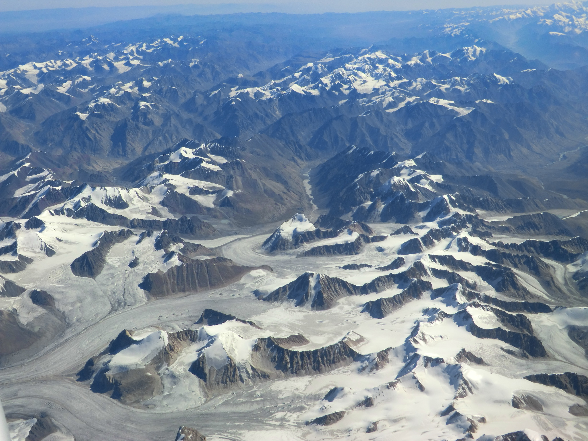
Der äußerste Norden des Faltengebirges jenseits des Transalaigebirges gehört zu Kirgisistan (Gebiet Osch), der Osten jenseits der Sarikolkette zu China (autonomes Gebiet Xinjiang), der Süden zu Afghanistan (Provinz Badachschan), der Rest zu Tadschikistan. Innerhalb Tadschikistans gehört der Pamir hauptsächlich zur autonomen Provinz Berg-Badachschan. Daneben haben nördlich der Darwaskette die der Republik unterstellten Bezirke Anteil am Gebirge, ferner in den westlichsten Ausläufern die Provinz Chatlon.
Der Pamir verbindet einige der großen Gebirgszüge Asiens: Zum Tianshan und dem Alaigebirge im Norden ist er durch das Alai-Tal mit den Flussläufen von Kysylsuu und Surchob abgegrenzt, zum Kunlun Shan im Südosten durch die Flusstäler von Taxkorgan und Yarkant. Im Süden und Südwesten bilden die Läufe von Wachandarja und Pandsch die Abgrenzung zum Hindukusch und indirekt auch zum Karakorum. Im Osten des Pamir schließt das Tarimbecken an, das im Süden durch das Hochland von Tibet begrenzt wird.
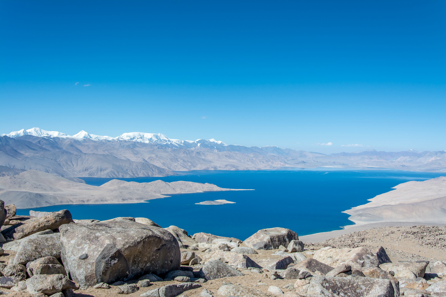
Die mittlere Höhe des Pamirs liegt bei etwa 3600 bis 4400 m, was meist über der hier bei 3700 m liegenden Baumgrenze liegt. Der größte See im Pamir ist der Karakul in Tadschikistan. Der längste Gletscher ist der 70 km lange Fedtschenko-Gletscher. Es gibt häufig Erdbeben, durch eines entstand 1911 der Saressee.
Orografisch gehört der größte Teil des Pamir zum Einzugsgebiet des Amudarja und wird somit zum Aralsee entwässert. Tatsächlich umfassen die Läufe der Amudarja-Quellflüsse Kysylsuu, Surchob, Wachsch und Pandsch den Pamir im Norden, Süden und Westen. Entsprechend münden auch weitere große Flüsse des Pamir in diese, darunter der namensgleiche Pamir, der Gunt und der Bartang in den Pandsch, der Obichingou in den Wachsch und der Muksu in den Surchob. Im Osten wird der Pamir zum Tarimbecken entwässert, wobei neben dem Taxkorgan auch der Gez zu erwähnen ist. Im Nordosten wiederum bildet der ebenfalls Kysylsuu genannte Quellfluss des Kaxgar, der wie sein westlicher Namensvetter ebenfalls im Alai-Tal verläuft und von diesem durch den 3536 m hohen Taunmurun-Pass getrennt ist, eine weitere Einfassung des Gebirges.
Das Klima ist rau und trocken. Die Bewohner sind meist Viehzüchter und halten Yaks und Fettschwanzschafe. Das Gebirge ist durch den Pamir Highway erschlossen.
パミール高原(パミールこうげん、英語: Pamir Mountains)あるいはパミル高原は、タジキスタン、アフガニスタン、中国などにまたがる平均標高5000メートルに達する高原で、中国では葱嶺(そうれい)と呼ばれていた[1]。「パミール」は、タジク語で「世界の屋根」を意味するといわれる[2]。
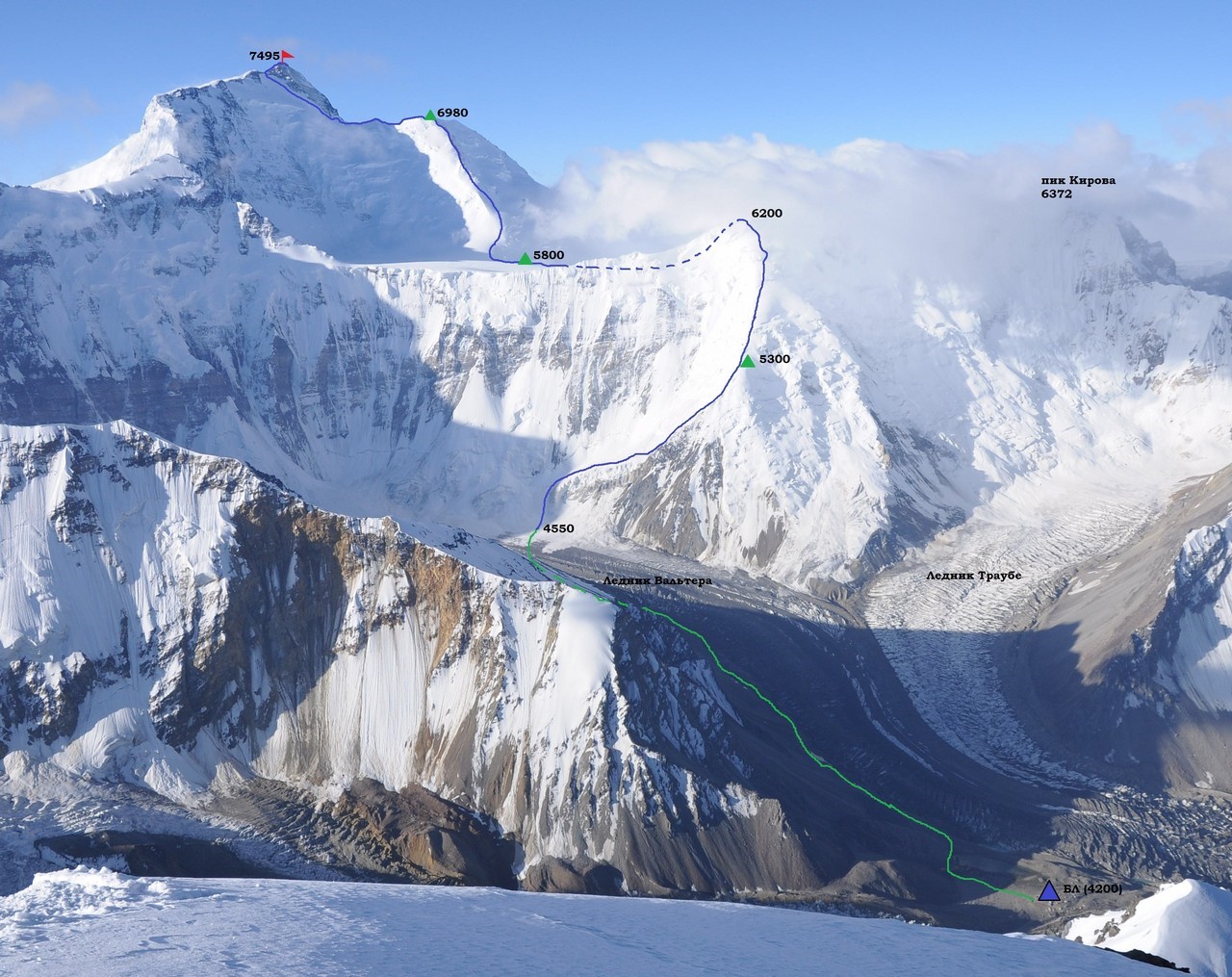
東パミール、中部パミール、西パミールに分かれ、東パミールの中国領に最高峰コングール山(7719メートル)やムスタグアタ山(7546メートル)があり、西パミールの最高峰はタジキスタン領のイスモイル・ソモニ峰(7495メートル)である[1]。
この高原から東北に向かって天山山脈、南方に向かって崑崙山脈、カラコルム山脈、ヒマラヤ山脈、西南に向かってヒンドゥークシュ山脈が伸びており、「世界の屋根」と呼ぶにふさわしい地形である[3]。タクラマカン砂漠を通るシルクロードは、この高原を越えて東西を結んでいた。
タジキスタン東部のゴルノ・バダフシャン自治州にはイラン系のパミール人やテュルク系のキルギス人が暮らしている。
The Pamir Mountains are a mountain range between Central Asia, South Asia, and East Asia, at the junction of the Himalayas with the Tian Shan, Karakoram, Kunlun, Hindu Kush, and Hindu Raj ranges. They are among the world's highest mountains.
The Pamir Mountains lie mostly in the Gorno-Badakhshan Province of Tajikistan.[1] To the north, they join the Tian Shan mountains along the Alay Valley of Kyrgyzstan. To the south, they border the Hindu Kush mountains along Afghanistan's Wakhan Corridor. To the east, they extend to the range that includes China's Kongur Tagh, in the "Eastern Pamirs",[2] separated by the Yarkand valley from the Kunlun Mountains.
Le Pamir est un massif de haute montagne centré sur l'Est du Tadjikistan avec des prolongements en Afghanistan, en République populaire de Chine et au Kirghizistan. Situé à la jonction entre plusieurs systèmes orographiques d'Asie centrale et du Tibet, il possède trois sommets principaux de plus de 7 000 mètres dont le pic Ismail Samani, généralement considéré comme son point culminant à 7 495 mètres d'altitude, ce qui a valu au massif le qualificatif de « toit du monde ». Son nom s'applique aussi bien à un certain type de vallée glaciaire plus fertile que les montagnes et les plateaux qui les entourent. Ces derniers sont généralement soumis à des conditions climatiques extrêmes, avec des précipitations très faibles et des écarts de températures importants, en particulier dans la moitié orientale désertique du massif. Toutefois, le Pamir est l'une des régions qui abritent le plus de glaciers en dehors des pôles, dont le glacier Fedtchenko avec 77 kilomètres de long. Ceci lui permet d'être parcouru par un grand nombre de rivières appartenant aux bassins de l'Amou-Daria à l'ouest et du Tarim à l'est, et de contenir des centaines de lacs. Alors que la pauvreté de la flore caractérise l'écorégion unique des toundra et désert d'altitude du Pamir, la faune est très diversifiée. Ainsi, l'Argali de Marco Polo est une espèce tout à la fois endémique et menacée de disparition.
Le massif est fréquenté depuis plusieurs millénaires. Il s'est trouvé sur des itinéraires secondaires de la route de la soie dès l'Antiquité. Toutefois, seuls les Tadjiks dès le IIe siècle puis les Kirghizes à partir du XVIe siècle y demeurent. Marco Polo est le premier Européen à faire mention, au XIIIe siècle, de sa traversée du Pamir. Rares sont ceux qui suivent ses pas jusqu'au milieu du XIXe siècle, lorsqu'il est exploré et placé au cœur d'un conflit géopolitique, le « Grand Jeu », entre l'Empire russe au nord et l'Inde britannique au sud. Le massif retombe dans l'oubli occidental au XXe siècle. Au XXIe siècle, il est peuplé par différentes populations qui se sont adaptées à la montagne : des Tadjiks, à l'ouest et au sud, et des Kirghizes, au nord et à l'est. Ces derniers mènent une vie semi-nomade, emmenant paître leurs animaux dans les quelques pamirs fertiles. Ils ont perpétué une culture riche de nombreuses traditions particulières.
Le Pamir reste une des régions les plus isolées au monde. Les infrastructures sont peu développées et la population continue à dépendre de l'aide extérieure. Le tourisme, essentiellement axé sur l'alpinisme, le trekking et l'écotourisme peine à se développer, malgré la présence de nombreuses aires protégées, notamment le parc national du Pamir qui est le plus grand d'Asie centrale.
Il Pamir è un elevato massiccio montuoso situato prevalentemente nella parte orientale del Tagikistan, ma anche nelle aree limitrofe di Afghanistan, Cina e Kirghizistan. Situato nel punto dove convergono vari sistemi orografici dell'Asia centrale e del Tibet, presenta tre cime principali che superano i 7000 metri, tra le quali il picco Ismail Samani (7495 metri), generalmente considerato la sua cima più alta, che hanno valso al massiccio l'appellativo di «tetto del mondo». Con il nome comune pamir (plurale pamiri) si indicano anche un certo tipo di valli glaciali più fertili delle montagne e degli altopiani circostanti, che sono generalmente caratterizzati da condizioni climatiche estreme, con precipitazioni molto scarse ed escursioni termiche considerevoli, in particolare nella parte orientale desertica del massiccio. Tuttavia, il Pamir è una delle regioni che ospitano più ghiacciai al di fuori dei poli, come il ghiacciaio Fedčenko, lungo 77 chilometri; di conseguenza esso è attraversato da un gran numero di fiumi appartenenti ai bacini dell'Amu Darya ad ovest e del Tarim ad est e ospita centinaia di laghi. Nonostante l'estrema scarsità della flora che caratterizza l'ecoregione della tundra e deserto d'altitudine del Pamir, la fauna è molto diversificata: tra le specie maggiormente degne di nota figura l'argali di Marco Polo, una specie endemica e in pericolo di estinzione.
L'uomo frequenta la regione del Pamir da vari millenni: essa si trova infatti lungo uno degli itinerari secondari della via della seta, che nell'Antichità attraversava l'Asia centrale, ma solamente i Tagiki a partire dal II secolo e i Kirghisi a partire dal XVI vi si sono insediati permanentemente. Marco Polo, nel XIII secolo, fu il primo europeo a raccontare la sua traversata del Pamir. Tuttavia, furono ben pochi quelli che seguirono le sue orme, almeno fino alla metà del XIX secolo, quando la zona venne esplorata e si trovò al centro di un conflitto geopolitico, il cosiddetto «Grande Gioco», tra l'Impero russo a nord e l'India britannica a sud. Finita quest'epoca, il Pamir ripiombò nuovamente nell'oblio durante il XX secolo. Attualmente, è abitato da varie popolazioni adattatesi a vivere in montagna: i Tagiki, ad ovest e a sud, e i Kirghisi, a nord e ad est. Questi ultimi, che si spostano con le loro greggi nei pochi pamiri fertili, conducono uno stile di vita semi-nomade e sono i custodi di una cultura ricca di tradizioni popolari.
Il Pamir rimane tuttora una delle regioni più isolate del mondo. Le infrastrutture sono poco sviluppate e la popolazione continua a dipendere dagli aiuti esterni. Anche il turismo, basato essenzialmente su alpinismo, trekking ed ecoturismo, stenta a svilupparsi, malgrado la presenza di numerose aree protette, tra le quali il parco nazionale del Pamir, il più grande dell'Asia centrale.
El Pamir, nudo del Pamir o Pamires —o incluso poco acertadamente cordillera del PamirNota 1—, es un macizo de alta montaña del Asia central centrado en la región del Alto Badajshán, en el este de Tayikistán, que se extiende por Afganistán, la República Popular de China, Kirguistán y Pakistán. Nudo orográficoIv. 1 situado en la unión de varios sistemas —los montes Tian, al norte, la cordillera del Kunlun, al este, los Karakoram, al sur, y el Hindu Kush, al suroeste1—, tiene tres cumbres principales de más de 7000 m —como el pico Ismail Samani, generalmente considerado como su punto culminante a 7495 m—, que lo convierten en el quinto sistema montañoso más alto del mundo, y una de los únicos seis que superan los sietemil metros. Junto al Tíbet, era conocido en tiempos victorianos como el «techo del mundo» (Roof of the World), en una traducción aproximada del término persa.2 Es conocido también por su nombre en chino, Congling.3
Pamir se aplica también a cierto tipo de valle glaciar más fértil que las montañas y las mesetas que lo rodean. Estos últimos están generalmente sujetos a condiciones climáticas extremas, con escasas precipitaciones y diferencias significativas de temperatura, en particular en la mitad oriental desértica del macizo. Sin embargo, el Pamir es una de las regiones que tiene más glaciares fuera de los polos, incluido el glaciar Fedchenko de 77 km de longitud. Esto le permite ser recorrido por una gran cantidad de ríos que pertenecen a las cuencas del Amu Daria, en el oeste, y a la del Tarim, en el este, y tener cientos de lagos. Si bien la pobreza de la flora caracteriza a la ecorregión única de tundra y desierto de altitud del Pamir, la fauna es muy diversa, sobresaliendo el argali de Marco Polo, una especie endémica y amenazada de extinción.
El macizo ha sido frecuentado por el hombre desde hace varios milenios. El lapis lazuli encontrado en las tumbas egipcias se considera que provenía de la región del Pamir.4 Hacia 138 a. C. Zhang Qian ascendió por el valle de Ferganá, al noroeste de los Pamires.4 Claudio Ptolomeo ya describió vagamente la ruta comercial en esta área.4 Aproximadamente en el año 600, peregrinos budistas viajaban a ambos lados de los Pamires para alcanzar la India desde China.4 En el año 747, un ejército de la dinastía Tang estuvo en el río Wakhan.4 Se encuentran en el macizo itinerarios secundarios de la ruta de la seda desde la Antigüedad. Sin embargo, solo los tayikos desde el siglo II y los kirguises a partir del siglo XVI se establecieron allí. Marco Polo fue el primer europeo en mencionar, en el siglo XIII, su travesía del Pamir. Pocos siguieron sus pasos hasta mediados del siglo XIX —se recuerda en 1602, a Bento de Goes, que viajaba desde Kabul a Yarkanda y dejó un informe sobre la cordillera del Pamir4— cuando fue explorado; en 1838 el teniente John Wood llegó a la cabecera del río Pamir.4 Desde aproximadamente 1868 hasta 1880, un número de hindúes del servicio secreto británico exploraron el área Panj.4 y la región fue colocada en el corazón de un conflicto geopolítico, El Gran Juego, entre el Imperio ruso, en el norte, y la India británica, en el sur. El macizo cayó en el olvido occidental en el siglo XX. En el siglo XXI, está poblado por diferentes poblaciones que se han adaptado a las montañas: tayikos, al oeste y sur, y kirguises, al norte y al este. Estos últimos llevan una vida seminómada, llevando a sus animales a pastar en los pocos pamires fértiles. Han perpetuado una cultura rica en muchas tradiciones particulares.
El Pamir sigue siendo una de las regiones más aisladas del mundo. Las infraestructuras están muy poco desarrolladas y la población sigue dependiendo de la ayuda externa. El turismo, enfocado principalmente en el montañismo, el trekking y el ecoturismo, está desarrollándose, a pesar de la existencia de muchas áreas protegidas, incluido el parque nacional Pamir, que es el más grande de Asia Central.
Cubiertos por la nieve la mayor parte del año, y batidos por abundantes granizadas, los Pamires gozan de un clima alpino de inviernos largos y muy fríos y veranos cortos y frescos. La precipitación anual, con un promedio de 130 mm, mantiene praderas y muy pocos árboles.
Пами́р (кит. упр. 帕米尔, пиньинь Pàmǐ'ěr, перс. پامیر, тадж. Помир) — горная система на юге Центральной Азии и на севере горной гряды Гималаи, преимущественно на территории Таджикистана (Горно-Бадахшанская автономная область)[к. 1][1], Китая, Афганистана и Пакистана. Памир находится на соединении отрогов других мощных горных систем Центральной Азии — Гиндукуша, Каракорума, Куньлуня и Тянь-Шаня[к. 2].
В XVIII—XX веках Памир и окружающие его области стали ареной геополитического соперничества Британской и Российской империй, что получило в истории британской геополитики название «Большая Игра»[к. 3].
В настоящее время Памир является узлом неразрешённых противоречий между рядом государств, что ведёт к геополитическому напряжению в регионе[2].
 Belarus

 Education and Research

 Hand in Hand

 Hand in Hand
 Institute of Culture and Language

 Hand in Hand
 Institute of Culture and Language
 Kasachstan
 Kyrgyzstan

 Art
Art

 Literature
 Russia
 Tajikistan

 United Nations
 Official languages
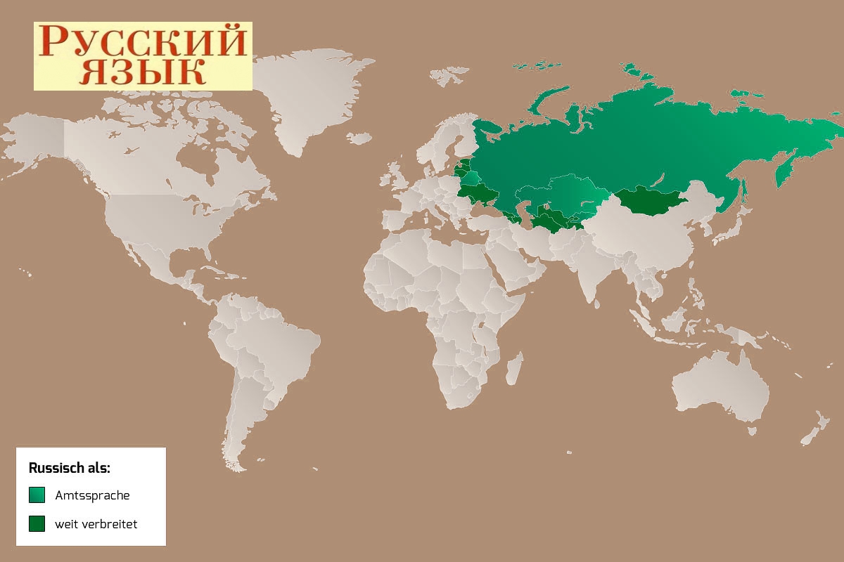
俄罗斯语(русский язык,罗马化:russkiy yazyk,发音:[ˈruskʲɪj jɪˈzɨk] (ⓘ)),通称俄语,属于斯拉夫语族的东斯拉夫语支,是斯拉夫语族中使用人数最多的语言,是俄罗斯、白俄罗斯、吉尔吉斯斯坦及哈萨克斯坦的官方语言,主要在俄罗斯等前苏联加盟共和国中使用,且在中国和华沙公约组织的成员国里曾经被学校广泛列为第一外语教学。俄文为联合国正式语文之一。在苏联时代,苏联加盟共和国和自治共和国非常强调俄语的重要性。虽然这些苏联的加盟共和国现在很多开始强调使用当地语言的重要性,在部分国家俄语已不再是官方语言,但俄语仍然是这些地区最广泛使用的共通语言。俄语属于印欧语系,是东斯拉夫语支中目前仍在使用的语言之一。目前发现最早的古东斯拉夫语文字是在十世纪的内容。俄语是欧亚大陆中分布区域广大的语言,也是斯拉夫语中最多人使用的语言。俄语也是欧洲最多人使用的母语,是俄罗斯、白俄罗斯、乌克兰1.44亿人的母语。
Die russische Sprache (Russisch, früher auch Großrussisch genannt; im Russischen: русский язык, [ˈru.skʲɪj jɪˈzɨk], deutsche Transkription: russki jasyk, wissenschaftliche Transliteration gemäß ISO 9:1968 russkij jazyk,[2] Ausspracheⓘ/?) ist eine Sprache aus dem slawischen Zweig der indogermanischen Sprachfamilie. Mit insgesamt etwa 250 Millionen Sprechern, davon ca. 150 Millionen Muttersprachlern, ist sie eine der meistverbreiteten Sprachen Europas. Sie gilt als eine der Weltsprachen. Sie spielt die Rolle der Lingua franca im postsowjetischen Raum und hat in mehreren seiner Staaten den Status einer Amtssprache.
Die eng mit dem Belarussischen, Ukrainischen und Russinischen verwandte Sprache wird mit dem kyrillischen Alphabet geschrieben, wobei es bestimmte russische Erscheinungsformen gibt. Die russische Standardsprache beruht auf den mittelrussischen Mundarten der Gegend um Moskau. Sie ist die Originalsprache zahlreicher bedeutender Werke der Weltliteratur. Die Wissenschaft, die sich mit der russischen Sprache und der umfangreichen russischen Literatur beschäftigt, heißt Russistik.
 Geography

 Financial
 Energy resource


 Military, defense and equipment
 Economy and trade