Deutsch-Chinesische Enzyklopädie, 德汉百科
 Shaanxi Sheng-SN
 History


Das Maoling-Mausoleum (auch Mao-Mausoleum oder Maoling) (chinesisch 茂陵, Pinyin Màolíng) bzw. Grab des Han-Kaisers Wudi (汉武帝墓, Hàn Wǔdì mù, englisch Maoling Mausoleum of Emperor Wudi of Han) ist das Grab des Han-Kaisers Wu (Hàn Wǔdì 汉武帝) bzw. „Wudi“ der Westlichen Han-Dynastie, der von 141-87 v. Chr. regierte. Es ist das größte der „Fünf Mausoleen“ (wǔlíng 五陵) der Westlichen Han-Dynastie (Xi Han wuling 西汉五陵) und wird auch als „Pyramide des Ostens“ (东方金字塔) bezeichnet.[1]
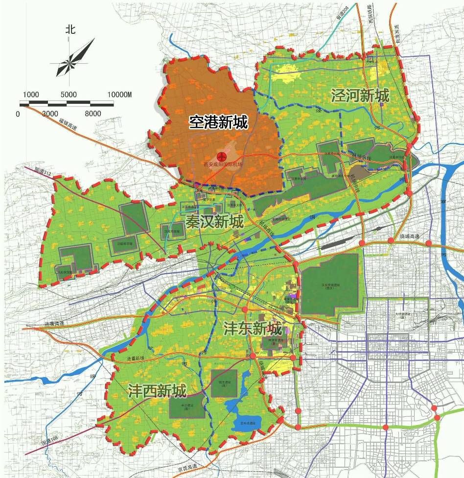
Das Grab liegt 40 km entfernt von der Provinzhauptstadt Xi’an im Dorf Maoling von Nanwei im Nordosten des Gebiets der heutigen Stadt Xingping (兴平市), einer kreisfreien Stadt der bezirksfreien Stadt Xianyang der Provinz Shaanxi in der Volksrepublik China.
Der Bau der Grabanlage begann im Jahr 139 v. Chr. und dauerte 53 Jahre. Die das Grab umgebende Mauer umfasst eine nahezu quadratische Grundfläche. Die Ost-West-Ausdehnung beträgt 431 m und die Nord-Süd-Ausdehnung 415 m. Die Mauer ist 5,8 Meter dick. In der Mitte eines jeden Mauerabschnitts befindet sich ein Tor. Das Grab selbst hat die Form einer stumpfen Pyramide mit einer Höhe von 46,5 m und einer größten Ausdehnung am Sockel von 240 m. Nach historischen Überlieferungen soll der Kaiser ein Drittel der Steuereinnahmen für den Bau der Grabstätte und deren Beigaben, die heute im Moaling Museum ausgestellt sind, genutzt haben.[2][3]
Rund um das Mausoleum befinden sich mehr als 20 weitere Gräber der Frauen und Konkubinen des Kaisers sowie der Minister. Zu diesen Nebengräbern gehören das Grab des Generals Huo Qubing, das Grab des Generals Wei Qing und das Grab von Jin Midi, die etwa einen Kilometer östlich vom Hauptgrab entfernt sind. Hier befindet sich auch das Maoling-Museum.
 Geography


Micang Shan (米倉山 / 米仓山, Mǐcāng Shān) ist ein Gebirge im Grenzgebiet der beiden chinesischen Provinzen Sichuan und Shaanxi.
Es bildet die Wasserscheide zwischen den Flüssen Han Jiang und Jialing Jiang. Die alte Micang-Straße (Micang dao 米仓道) führt durch das Gebirge.
米仓山,又称米仓山国家森林公园,位于中国四川省和陕西省交界处。西接摩天岭,东接大巴山,是汉江、嘉陵江的分水岭,古米仓道经此。主峰光雾山位于四川省南江县,海拔2507米。

 Economy and trade
Anhui Sheng-AH
Beijing Shi-BJ
Chongqing Shi-CQ
Fujian Sheng-FJ
Guangdong Sheng-GD
Hebei Sheng-HE
Hubei Sheng-HB
Hunan Sheng-HN
Jiangsu Sheng-JS
Jiangxi Sheng-JX
Jilin Sheng-JL
Liaoning Sheng-LN
Nei Mongol Zizhiqu-NM
Shaanxi Sheng-SN
Shandong Sheng-SD
Shanghai Shi-SH
Sichuan Sheng-SC
Tianjin Shi-TJ
Zhejiang Sheng-ZJ
Economy and trade
Anhui Sheng-AH
Beijing Shi-BJ
Chongqing Shi-CQ
Fujian Sheng-FJ
Guangdong Sheng-GD
Hebei Sheng-HE
Hubei Sheng-HB
Hunan Sheng-HN
Jiangsu Sheng-JS
Jiangxi Sheng-JX
Jilin Sheng-JL
Liaoning Sheng-LN
Nei Mongol Zizhiqu-NM
Shaanxi Sheng-SN
Shandong Sheng-SD
Shanghai Shi-SH
Sichuan Sheng-SC
Tianjin Shi-TJ
Zhejiang Sheng-ZJ
 Sport
Sport
 Beijing Shi-BJ
Beijing Shi-BJ
Beijing Shi-BJ
Beijing Shi-BJ
China
Guangdong Sheng-GD
Guangdong Sheng-GD
Jiangsu Sheng-JS
Liaoning Sheng-LN
Shaanxi Sheng-SN
Shandong Sheng-SD
Shanghai Shi-SH
Shanghai Shi-SH
Tianjin Shi-TJ
Beijing Shi-BJ
Beijing Shi-BJ
Beijing Shi-BJ
Beijing Shi-BJ
Beijing Shi-BJ
China
Guangdong Sheng-GD
Guangdong Sheng-GD
Jiangsu Sheng-JS
Liaoning Sheng-LN
Shaanxi Sheng-SN
Shandong Sheng-SD
Shanghai Shi-SH
Shanghai Shi-SH
Tianjin Shi-TJ

Die Chinesischen Nationalspiele, später Nationalspiele der Volksrepublik China (chinesisch 中華人民共和國全國運動會 / 中华人民共和国全国运动会 Zhōnghuá Rénmín Gònghéguó Quánguó Yùndònghuì) sind eine Multisportveranstaltung in China. Sie sind nicht zu verwechseln mit den All-Chinesischen Spielen für nichtolympische Sportarten.
 Transport and traffic
Beijing Shi-BJ
Belarus
Transport and traffic
Beijing Shi-BJ
Belarus
 Berlin
 Brandenburg
 Bremen
China
Germany
France
Gansu Sheng-GS
Bremen
China
Germany
France
Gansu Sheng-GS
 Hamburg
Hebei Sheng-HE
Heilongjiang Sheng-HL
Henan Sheng-HA
Hubei Sheng-HB
Hunan Sheng-HN
Iran
Italy
Jilin Sheng-JL
Kasachstan
Liaoning Sheng-LN
Nei Mongol Zizhiqu-NM
Netherlands
Hamburg
Hebei Sheng-HE
Heilongjiang Sheng-HL
Henan Sheng-HA
Hubei Sheng-HB
Hunan Sheng-HN
Iran
Italy
Jilin Sheng-JL
Kasachstan
Liaoning Sheng-LN
Nei Mongol Zizhiqu-NM
Netherlands
 Lower Saxony
Ningxia Huizu Zizhiqu-NX
Lower Saxony
Ningxia Huizu Zizhiqu-NX
 North Rhine-Westphalia
Poland
Portugal
Russia
North Rhine-Westphalia
Poland
Portugal
Russia
 Saxony
 Schleswig-Holstein
Shaanxi Sheng-SN
Shandong Sheng-SD
Shanxi Sheng-SX
Sichuan Sheng-SC
Spain
Turkey
Turkmenistan
Uzbekistan
United Kingdom
Xinjiang Uygur Zizhiqu-XJ
Zhejiang Sheng-ZJ
Schleswig-Holstein
Shaanxi Sheng-SN
Shandong Sheng-SD
Shanxi Sheng-SX
Sichuan Sheng-SC
Spain
Turkey
Turkmenistan
Uzbekistan
United Kingdom
Xinjiang Uygur Zizhiqu-XJ
Zhejiang Sheng-ZJ
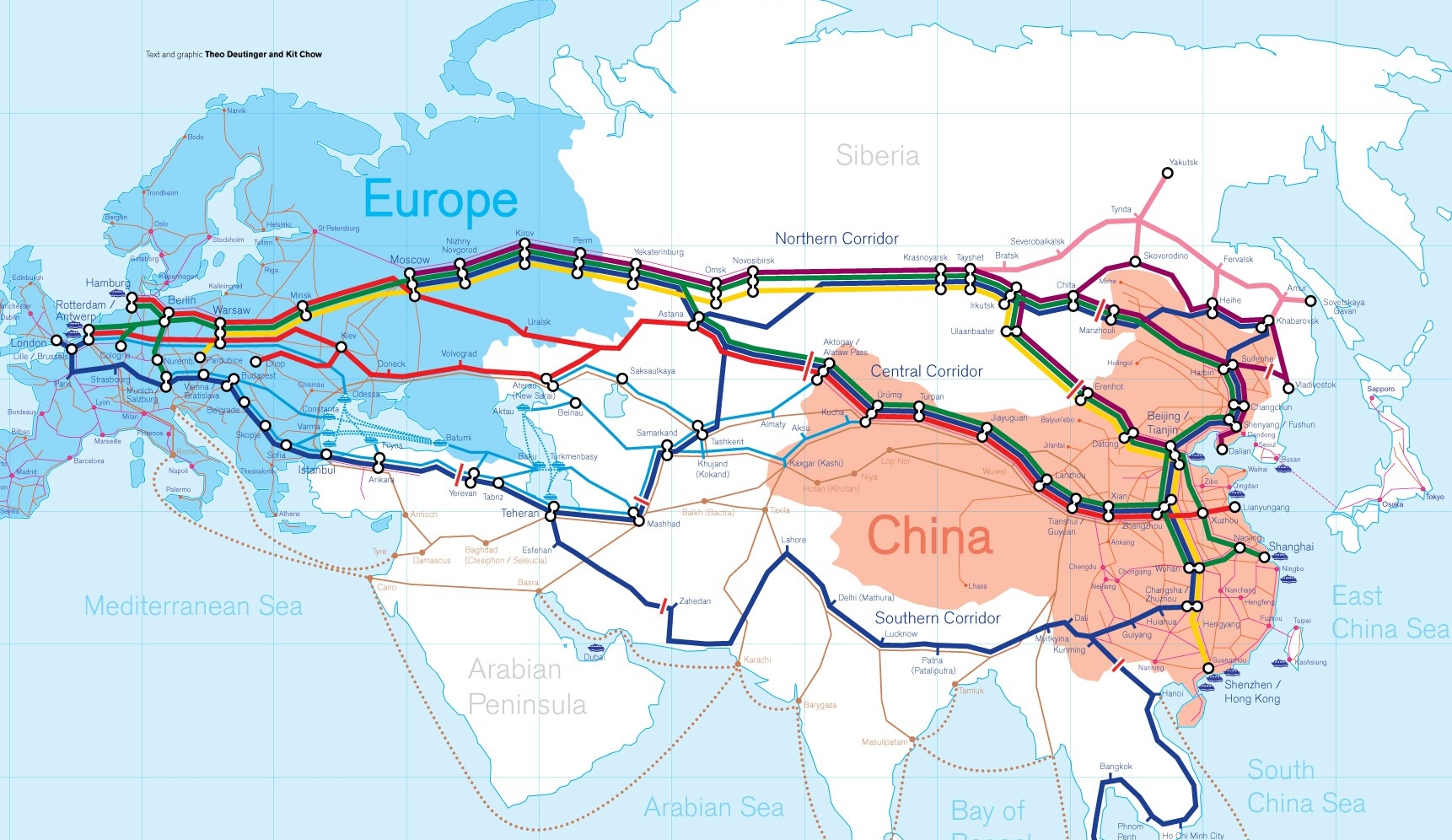
Die Neue eurasische Kontinentalbrücke (chinesisch 新亚欧大陆桥, Pinyin Xīn Yà-Ōu Dàlù Qiáo, englisch New Eurasian Continental Bridge), die auch Zweite eurasische Kontinentalbrücke (第二亚欧大陆桥, Dì'èr Yà-Ōu Dàlù Qiáo, englisch Second Eurasian Continental Bridge) genannt wird, ist eine 10.870 Kilometer[1] lange Eisenbahnverbindung, die Rotterdam in Europa mit der ostchinesischen Hafenstadt Lianyungang in der Provinz Jiangsu verbindet.
Sie besteht seit 1990 und führt durch die Dsungarische Pforte (Grenzbahnhof Alashankou). Die Lan-Xin-Bahn (chinesisch 兰新铁路, Pinyin Lán-Xīn Tiělù), also die Strecke von Lanzhou nach Ürümqi (in Xinjiang), ist ein Teil von ihr.
Es gibt eine nördliche, mittlere und südliche Route.[2] Die mittlere Strecke verläuft durch Kasachstan über Dostyk, Aqtogai, Astana, Samara, Smolensk, Brest, Warschau, Berlin zum Hafen von Rotterdam.[3] Vom slowakischen Košice soll auch eine Abzweigung in den Großraum Wien führen, siehe Breitspurstrecke Košice–Wien.
The New Eurasian Land Bridge, also called the Second or New Eurasian Continental Bridge, is the southern branch of the Eurasian Land Bridge rail links running through China. The Eurasian Land Bridge is the overland rail link between Asia and Europe.
Due to a break-of-gauge between standard gauge used in China and the Russian gauge used in the former Soviet Union countries, containers must be physically transferred from Chinese to Kazakh railway cars at Dostyk on the Chinese-Kazakh border and again at the Belarus-Poland border where the standard gauge used in western Europe begins. This is done with truck-mounted cranes.[1] Chinese media often states that the New Eurasian Land/Continental Bridge extends from Lianyungang to Rotterdam, a distance of 11,870 kilometres (7,380 mi). The exact route used to connect the two cities is not always specified in Chinese media reports, but appears to usually refer to the route which passes through Kazakhstan.
All rail freight from China across the Eurasian Land Bridge must pass north of the Caspian Sea through Russia at some point. A proposed alternative would pass through Turkey and Bulgaria,[2] but any route south of the Caspian Sea must pass through Iran.[1]
Kazakhstan's President Nursultan Nazarbayev urged Eurasian and Chinese leaders at the 18th Shanghai Cooperation Organisation to construct the Eurasian high-speed railway (EHSRW) following a Beijing-Astana-Moscow-Berlin.[3]
The Eurasian Land Bridge (Russian: Евразийский сухопутный мост, Yevraziyskiy sukhoputniy most), sometimes called the New Silk Road (Новый шёлковый путь, Noviy shyolkoviy put'), or Belt and Road Initiative is the rail transport route for moving freight and passengers overland between Pacific seaports in the Russian Far East and China and seaports in Europe. The route, a transcontinental railroad and rail land bridge, currently comprises the Trans-Siberian Railway, which runs through Russia and is sometimes called the Northern East-West Corridor, and the New Eurasian Land Bridge or Second Eurasian Continental Bridge, running through China and Kazakhstan. As of November 2007, about 1% of the $600 billion in goods shipped from Asia to Europe each year were delivered by inland transport routes.[1]
Completed in 1916, the Trans-Siberian connects Moscow with Russian Pacific seaports such as Vladivostok. From the 1960s until the early 1990s the railway served as the primary land bridge between Asia and Europe, until several factors caused the use of the railway for transcontinental freight to dwindle. One factor is that the railways of the former Soviet Union use a wider rail gauge than most of the rest of Europe as well as China. Recently, however, the Trans-Siberian has regained ground as a viable land route between the two continents.[why?]
China's rail system had long linked to the Trans-Siberian via northeastern China and Mongolia. In 1990 China added a link between its rail system and the Trans-Siberian via Kazakhstan. China calls its uninterrupted rail link between the port city of Lianyungang and Kazakhstan the New Eurasian Land Bridge or Second Eurasian Continental Bridge. In addition to Kazakhstan, the railways connect with other countries in Central Asia and the Middle East, including Iran. With the October 2013 completion of the rail link across the Bosphorus under the Marmaray project the New Eurasian Land Bridge now theoretically connects to Europe via Central and South Asia.
Proposed expansion of the Eurasian Land Bridge includes construction of a railway across Kazakhstan that is the same gauge as Chinese railways, rail links to India, Burma, Thailand, Malaysia and elsewhere in Southeast Asia, construction of a rail tunnel and highway bridge across the Bering Strait to connect the Trans-Siberian to the North American rail system, and construction of a rail tunnel between South Korea and Japan. The United Nations has proposed further expansion of the Eurasian Land Bridge, including the Trans-Asian Railway project.
El Nuevo Puente de Tierra de Eurasia es también llamado el Segundo o Nuevo Puente Continental de Eurasia. Es la rama meridional de las conexiones ferroviarias del Puente de Tierra de Eurasia (también conocido como "Nueva Ruta de la Seda") que se extienden a través de la República Popular China, atravesando Kazajistán, Rusia y Bielorrusia. El Puente de Tierra de Eurasia es el enlace ferroviario terrestre entre Asia Oriental y Europa.
La Nueva Ruta de la Seda (en ruso, Новый шёлковый путь, Noviy shyolkoviy put), o Puente Terrestre Euroasiático, es la ruta de transporte ferroviario para el movimiento de tren de mercancías y tren de pasajeros por tierra entre los puertos del Pacífico, en el Lejano Oriente ruso y chino y los puertos marítimos en Europa.
La ruta, un ferrocarril transcontinental y puente terrestre, actualmente comprende el ferrocarril Transiberiano, que se extiende a través de Rusia, y el nuevo puente de tierra de Eurasia o segundo puente continental de Eurasia, que discurre a través de China y Kazajistán, también se van a construir carreteras entre las ciudades de la ruta. A partir de noviembre de 2007, aproximadamente el 1% de los 600 millones de dólares en bienes enviados desde Asia a Europa cada año se entregaron por vías de transporte terrestre.1
Terminado en 1916, el tren Transiberiano conecta Moscú con el lejano puerto de Vladivostok en el océano Pacífico, el más largo del mundo en el Lejano Oriente e importante puerto del Pacífico. Desde la década de 1960 hasta principios de 1990 el ferrocarril sirvió como el principal puente terrestre entre Asia y Europa, hasta que varios factores hicieron que el uso de la vía férrea transcontinental para el transporte de carga disminuyese.
Un factor es que los ferrocarriles de la Unión Soviética utilizan un ancho de vía más ancho en los rieles que la mayor parte del resto de Europa y China, y el transporte en barcos de carga por el canal de Suez en Egipto, construido por Inglaterra. El sistema ferroviario de China se une al Transiberiano en el noreste de China y Mongolia. En 1990 China añadió un enlace entre su sistema ferroviario y el Transiberiano a través de Kazajistán. China denomina a su enlace ferroviario ininterrumpido entre la ciudad portuaria de Lianyungang y Kazajistán como el «Puente terrestre de Nueva Eurasia» o «Segundo puente continental Euroasiático». Además de Kazajistán, los ferrocarriles conectan con otros países de Asia Central y Oriente Medio, incluyendo a Irán. Con la finalización en octubre de 2013 de la línea ferroviaria a través del Bósforo en el marco del proyecto Marmaray el puente de tierra de Nueva Eurasia conecta ahora teóricamente a Europa a través de Asia Central y del Sur.
La propuesta de ampliación del Puente Terrestre Euroasiático incluye la construcción de un ferrocarril a través de Kazajistán con el mismo ancho de vía que los ferrocarriles chinos, enlaces ferroviarios a la India, Birmania, Tailandia, Malasia y otros países del sudeste asiático, la construcción de un túnel ferroviario y un puente de carretera a través del estrecho de Bering para conectar el Transiberiano al sistema ferroviario de América del Norte, y la construcción de un túnel ferroviario entre Corea del Sur y Japón. Las Naciones Unidas ha propuesto una mayor expansión del Puente Terrestre Euroasiático, incluyendo el proyecto del ferrocarril transasiático.
Новый шёлковый путь (Евразийский сухопутный мост — концепция новой паневразийской (в перспективе — межконтинентальной) транспортной системы, продвигаемой Китаем, в сотрудничестве с Казахстаном, Россией и другими странами, для перемещения грузов и пассажиров по суше из Китая в страны Европы. Транспортный маршрут включает трансконтинентальную железную дорогу — Транссибирскую магистраль, которая проходит через Россию и второй Евразийский континентальный мост[en], проходящий через Казахстан[1]. Поезда по этому самому длинному в мире грузовому железнодорожному маршруту из Китая в Германию будут идти 15 дней, что в 2 раза быстрее, чем по морскому маршруту через Суэцкий канал[2].
Идея Нового шёлкового пути основывается на историческом примере древнего Великого шёлкового пути, действовавшего со II в. до н. э. и бывшего одним из важнейших торговых маршрутов в древности и в средние века. Современный НШП является важнейшей частью стратегии развития Китая в современном мире — Новый шёлковый путь не только должен выстроить самые удобные и быстрые транзитные маршруты через центр Евразии, но и усилить экономическое развитие внутренних регионов Китая и соседних стран, а также создать новые рынки для китайских товаров (по состоянию на ноябрь 2007 года, около 1 % от товаров на 600 млрд долл. из Азии в Европу ежегодно доставлялись наземным транспортом[3]).
Китай продвигает проект «Нового шёлкового пути» не просто как возрождение древнего Шёлкового пути, транспортного маршрута между Востоком и Западом, но как масштабное преобразование всей торгово-экономической модели Евразии, и в первую очередь — Центральной и Средней Азии. Китайцы называют эту концепцию — «один пояс — один путь». Она включает в себя множество инфраструктурных проектов, которые должны в итоге опоясать всю планету. Проект всемирной системы транспортных коридоров соединяет Австралию и Индонезию, всю Центральную и Восточную Азию, Ближний Восток, Европу, Африку и через Латинскую Америку выходит к США. Среди проектов в рамках НШП планируются железные дороги и шоссе, морские и воздушные пути, трубопроводы и линии электропередач, и вся сопутствующая инфраструктура. По самым скромным оценкам, НШП втянет в свою орбиту 4,4 миллиарда человек — более половины населения Земли[4].
Предполагаемое расширение Евразийского сухопутного моста включает в себя строительство железнодорожных путей от трансконтинентальных линий в Иран, Индию, Мьянму, Таиланд, Пакистан, Непал, Афганистан и Малайзию, в другие регионы Юго-Восточной Азии и Закавказья (Азербайджан, Грузия). Маршрут включает тоннель Мармарай под проливом Босфор, паромные переправы через Каспийское море (Азербайджан-Иран-Туркменистан-Казахстан) и коридор Север-Юг.Организация Объединенных Наций предложила дальнейшее расширение Евразийского сухопутного моста, в том числе проекта Трансазиатской железной дороги (фактически существует уже в 2 вариантах).
Для развития инфраструктурных проектов в странах вдоль Нового шёлкового пути и Морского Шёлкового пути и с целью содействия сбыту китайской продукции в декабре 2014 года был создан инвестиционный Фонд Шёлкового пути[5].
8 мая 2015 года было подписано совместное заявление Президента РФ В. Путина и Председателя КНР Си Цзиньпина о сотрудничестве России и Китая, в рамках ЕАЭС и трансевразийского торгово-инфраструктурного проекта экономического пояса «Шёлковый путь». 13 июня 2015 года был запущен самый длинный в мире грузовой железнодорожный маршрут Харбин — Гамбург (Германия), через территорию России.
 Spring Festival


(Quelle:https://www.ccmapp.cn/)
Gansu Sheng-GS
Ningxia Huizu Zizhiqu-NX
Northwest China
Qinghai Sheng-QH
Shaanxi Sheng-SN
Xinjiang Uygur Zizhiqu-XJ