
漢德百科全書 | 汉德百科全书
 Argentina


Die Anden (spanisch Cordillera de los Andes, Quechua Anti bzw. Antis) sind die längste (über dem Meeresspiegel befindliche) Gebirgskette der Erde und das höchste Gebirge außerhalb Asiens. Sie bilden den Südteil der Amerikanischen Kordilleren, die in Mittelamerika orographisch unterbrochen sind.
Sie erstrecken sich entlang der Westküste Südamerikas von Venezuela über Kolumbien, Ecuador, Peru, Bolivien, Argentinien und Chile. Mit einer Nord-Süd-Ausdehnung von 7500 Kilometern von den Tropen (bei 10° Nord) bis weit in die Außertropen (bei 55° Süd) übertreffen sie die Rocky Mountains Nordamerikas (4800 km) um etwa die Hälfte und haben fast die doppelte Ausdehnung des Himalaya-Karakorum-Hindukusch-Systems in Asien mit seinen 4400 Kilometern. Im Süden und in Ecuador sind sie bis 200 km breit. Zwischen Arica (Chile) und Santa Cruz de la Sierra (Bolivien) beträgt die Ost-West-Ausdehnung über 600 Kilometer.
安第斯山脉(西班牙语:Cordillera de los Andes;奇楚亚语:Walla Antikuna),也称安弟斯山脉或安蒂斯山脉,是陆地上最长的山脉,位于南美洲的西岸,约7,000公里长,200至700公里宽(最宽的部分在南纬18度到20度之间),平均高度约4,000米,由北到南经过委内瑞拉、哥伦比亚、厄瓜多尔、秘鲁、玻利维亚、智利及阿根廷等国。
安第斯山脉由于其中的地形凹陷,可以分为几个不同的区域。安第斯山脉中有几个高原,其中也有一些大城市,例如基多、波哥大、阿雷基帕、麦德林、苏克雷、梅里达市和拉巴。阿尔蒂普拉诺高原是世界第二大的高原,仅次于亚洲的青藏高原。安第斯山脉依气候可分为三区:热带安第斯、乾安地斯及湿安第斯。
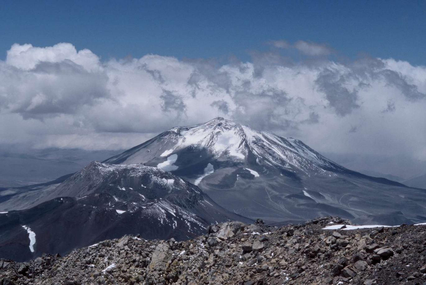
安第斯山脉最高峰是位在阿根廷境内的阿空加瓜山,高度6,962米,是美洲第一高峰,也是世界第一高的火山。因为地球自转产生的赤道隆起,赤道位置的地球半径会较其他地方要大,因此位于赤道附近的钦博拉索山是地表离地心最远的位置。世界最高的火山在安第斯山脉,包括高度为6,893米的奥霍斯-德尔萨拉多山,另外在安第斯山脉有五十座火山的高度超过6,000米。安第斯山脉中的图蓬加托火山是世界上最高的活火山,海拔约6,600米。
アンデス山脈(アンデスさんみゃく、スペイン語: Cordillera de los Andes)は、主に南アメリカ大陸の西側に沿って、北緯10度から南緯50度まで南北7500km、幅750kmにわたる世界最長の連続した褶曲(しゅうきょく)山脈である。山脈はベネズエラ、コロンビア、エクアドル、ペルー、ボリビア、アルゼンチン、チリの7カ国にまたがる。 最高峰はアコンカグア(6960m・一説には7021m)で、6000mを越える高峰が20座以上そびえ立っている。山脈が現在の姿になり始めたのは白亜紀で、その後現在まで太平洋プレート、ナスカプレートと南米大陸のぶつかり合いで隆起し、場所により異なる構造運動を受けて大きくなったと考えられている。
The Andes, Andes Mountains or Andean Mountains (Spanish: Cordillera de los Andes) are the longest continental mountain range in the world, forming a continuous highland along the western edge of South America. The range is 7,000 km (4,300 mi) long, 200 to 700 km (120 to 430 mi) wide (widest between 18° south and 20° south latitude), and has an average height of about 4,000 m (13,000 ft). The Andes extend from north to south through seven South American countries: Venezuela, Colombia, Ecuador, Peru, Bolivia, Chile, and Argentina.
Along their length, the Andes are split into several ranges, separated by intermediate depressions. The Andes are the location of several high plateaus—some of which host major cities such as Quito, Bogotá, Cali, Arequipa, Medellín, Bucaramanga, Sucre, Mérida and La Paz. The Altiplano plateau is the world's second-highest after the Tibetan plateau. These ranges are in turn grouped into three major divisions based on climate: the Tropical Andes, the Dry Andes, and the Wet Andes.
The Andes Mountains are the highest mountain range outside Asia. The highest mountain outside Asia, Argentina's Mount Aconcagua, rises to an elevation of about 6,961 m (22,838 ft) above sea level. The peak of Chimborazo in the Ecuadorian Andes is farther from the Earth's center than any other location on the Earth's surface, due to the equatorial bulge resulting from the Earth's rotation. The world's highest volcanoes are in the Andes, including Ojos del Salado on the Chile-Argentina border, which rises to 6,893 m (22,615 ft).
The Andes are also part of the American Cordillera, a chain of mountain ranges (cordillera) that consists of an almost continuous sequence of mountain ranges that form the western "backbone" of North America, Central America, South America and Antarctica.
La cordillère des Andes, en espagnol Cordillera de los Andes, est la plus longue chaîne de montagnes continentale du monde2, orientée nord-sud tout le long de la côte occidentale de l'Amérique du Sud. Longue d'environ 7 100 kilomètres, large de 200 à 800 kilomètres (entre le 18 et le 20° de latitude Sud), la cordillère a une altitude moyenne de 4 000 mètres et culmine à 6 962 mètres. Elle débute au Venezuela au nord puis traverse la Colombie, l'Équateur, le Pérou, la Bolivie, le Chili et l'Argentine, jusqu'à la pointe sud du continent.
Les Andes sont la plus haute chaîne de montagnes d'Amérique. Le sommet le plus élevé est l'Aconcagua, avec ses 6 962 mètres d'altitude1, situé en Argentine. Le faîte du volcan Chimborazo dans les Andes équatoriennes, est le point le plus éloigné du centre de la Terre, en raison du renflement du globe au niveau de l'équateur. Plusieurs volcans sont présents, figurant parmi les plus hautes montagnes sur Terre après celles d'Asie et dépassant 6 000 mètres d'altitude.
La cordigliera delle Ande (in spagnolo Cordillera de los Andes) è un'importante catena montuosa dell'America meridionale, situata nella parte più occidentale del continente, attraversando sette stati: Venezuela, Colombia, Ecuador, Perù, Bolivia, Cile e Argentina, alcuni dei quali sono noti come Paesi andini: rappresenta il settore meridionale della più estesa Cordigliera Americana che, partendo dall'Alaska, costeggia l'intero versante rivolto verso l'Oceano Pacifico dell'intero continente americano e che termina alla Terra del Fuoco.
Formata principalmente da due grandi settori: la Cordillera Oriental e la Cordillera Occidental, in gran parte separati da una profonda depressione intermedia, in cui sorgono altre catene di importanza minore, la principale delle quali è Cordillera de la Costa cilena (altre piccole catene sorgono ai lati delle grandi catene), è anche la più alta catena montuosa al di fuori del continente asiatico, toccando i 6962 m sopra il livello del mare con la cima più alta, l'Aconcagua, mentre la vetta del vulcano Chimborazo, nelle Ande ecuadoriane, è il punto della superficie terrestre più lontano dal centro della Terra a causa del rigonfiamento equatoriale.
Con i suoi 7200 km di lunghezza (dall'istmo di Panama, a nord, fino a Capo Horn, a sud) è tradizionalmente considerata la catena montuosa più lunga del mondo[1], rappresentando l'ideale prosecuzione verso sud delle catene montuose dell'America nord-occidentale e centrale, la sua larghezza media è invece di 240 km, toccando nel punto più esteso i 500 km (fra il 18º e il 20º parallelo sud), mentre l'altezza media è di circa 4000 m.
La cordillera de los Andes es la cordillera que ocupa la zona occidental de América del Sur bordeando toda su costa del océano Pacífico. Tiene una longitud de 8500 km1 por lo que es la cordillera continental más larga de la Tierra. Desde su extremo norte, en el occidente de Venezuela, atraviesa Colombia, Ecuador, Perú y Bolivia; sirve de frontera natural entre Chile y Argentina y tiene su extremo sur en Tierra del Fuego. Tiene un ancho variable entre 250 y 750 km.2 Ocupa una superficie aproximada de 2 870 000 km².3 Su altura media está entre 3000 y 4000 m s. n. m.,1 alberga los volcanes más altos del planeta y su punto más alto es el Aconcagua, cuyos 6960,8 m s. n. m.4 hacen de esta montaña la más alta del planeta fuera del Asia. Por su importante actividad volcánica forma parte de cinturón de Fuego del Pacífico.
En la zona central, los Andes se ensanchan, dando lugar a las mesetas elevadas del altiplano y la puna, compartidas por Argentina, Bolivia, Chile y Perú. Desde el altiplano central hacia el norte del Perú y en Ecuador se vuelve angosta nuevamente y en Colombia se divide en tres ramas, una de los cuales continúa hacia noroeste entrando en Venezuela. Desde el altiplano hacia el sur, la cordillera tiene dirección general norte-sur y , zona en la que se hallan las montañas más altas. En el extremo austral, se curva y toma dirección este-oeste y se hunde en el océano Atlántico al este de la isla de los Estados.5
Se formó al final de la era Mesozoica, a finales del Cretácico tardío, por el movimiento de la convergencia de la placa de Nazca debajo de la placa sudamericana. Los movimientos sísmicos y la actividad volcánica posteriores han tenido más importancia en la configuración del relieve que los agentes erosivos externos. En la morfología actual se encuentran elevadas cordilleras, junto con extensos altiplanos y profundos valles longitudinales paralelos a los grandes ejes montañosos. Los valles transversales son escasos, salvo en los Andes argentinos-chilenos.
Muchos de los principales depósitos de minerales metálicos del mundo están asociados con bordes de placas convergentes, como los Andes o las montañas Rocosas.
А́нды, А́ндские Кордилье́ры (исп. Andes; Cordillera de los Andes) — одна из самых длинных (9000 км)[1] и одна из самых высоких (гора Аконкагуа, 6961 м)[2] горных систем Земли, окаймляющая с севера и запада всю Южную Америку; южная часть Кордильер. Местами Анды достигают ширины свыше 500 км (наибольшая ширина — до 750 км — в Центральных Андах, между 18° и 20° ю. ш.)[3]. Средняя высота — около 4000 м.
Анды являются крупным межокеанским водоразделом; к востоку от Анд текут реки бассейна Атлантического океана (в Андах берут начало сама Амазонка и многие её крупные притоки, а также притоки Ориноко, Парагвая, Параны, река Магдалена и реки Патагонии), к западу — реки бассейна Тихого океана (преимущественно короткие).
Анды служат важнейшим в Южной Америке климатическим барьером, изолирующим территории к западу от Главной Кордильеры от влияния Атлантического океана, к востоку — от влияния Тихого океана. Горы лежат в 5 климатических поясах (экваториальном, субэкваториальном, тропическом, субтропическом и умеренном) и отличаются (особенно в центральной части) резкими контрастами в увлажнении восточных (подветренных) и западных (наветренных) склонов.
В силу значительной протяжённости Анд отдельные их ландшафтные части значительно отличаются друг от друга. По характеру рельефа и другим природным отличиям, как правило, выделяют три основных региона — Северные, Центральные и Южные Анды.
Анды протянулись через территории семи государств Южной Америки — Венесуэлы, Колумбии, Эквадора, Перу, Боливии, Чили и Аргентины.

Als Andenzivilisation, auch Altperu[1], werden komplexe Gesellschaften (Zivilisationen) bezeichnet, die sich im Andenraum einschließlich der Pazifikküste im Westen Südamerikas vor der Ankunft der Europäer entwickelten. Neben Peru umfasst dieser Kulturraum insbesondere Kolumbien, Ecuador, Bolivien, Chile und Argentinien. Der Andenraum mit seiner trockenen Pazifikküste, den östlich gelegenen feuchtwarmen Gebieten des Amazonasregenwaldes und den hohen beschneiten Gipfel der Anden bot mit seiner sich zwischen 2.500 und 3.500 m erstreckenden Sierra günstige landwirtschaftliche Bedingungen (gleichmäßiges Klima, fruchtbarer Boden) und begünstigte so die Besiedlung des Andenraums. Ähnliches galt für den Altiplano, ein abflussloses steppenartiges Gebiet zwischen 3.000 und 4.500 m mit dem Titicacasee. Wann die ersten Menschen nach Südamerika einwanderten, ist unbekannt. Einige Forscher nehmen an, dass der Andenraum über die Landenge von Panama besiedelt wurde.
安第斯文明是指位于哥伦比亚南部的安地斯山脉、秘鲁沿海沙漠以及智利和阿根廷西北部的由多种文化和民族组成的文明。秘鲁的小北文明是美洲已知最古老的文明,它的历史可追溯到公元前3200年。

Veranstaltungen Spiele der argentinischen Fußballnationalmannschaft Campeonato Sudamericano 1946 Panamerikanische Spiele 1951 (Leichtathletik, Abschlussfeier) Campeonato Sudamericano 1959 Entscheidungsspiel der Copa Campeones de América 1962 Finalrückspiel der Copa Libertadores 1966 Finalrückspiel der Copa Libertadores 1976 Fußball-Weltmeisterschaft 1978 Copa América 1979 Copa América 1983 Finalhinspiel der Copa Libertadores 1985 Finalrückspiel der Copa Libertadores 1986 Copa América 1987 Finalrückspiel der Copa Interamericana 1987 Finalhinspiel der Supercopa Sudamericana 1991 Finalrückspiel der Supercopa Sudamericana 1997 Finalrückspiel der Recopa Sudamericana 1998 Finalhinspiel der Copa Sudamericana 2003 Copa América 2011 Finalrückspiel der Copa Sudamericana 2014 Finalrückspiel der Copa Libertadores 2015 Hinspiel der Recopa Sudamericana 2015 Rückspiel der Recopa Sudamericana 2016

 Alberta-AB
 Argentina
 Australia

 Auvergne-Rhône-Alpes

 Bavaria
 Beijing Shi-BJ

 Berlin
 Bosnia Herzegovina
 Brazil

 British Columbia-BC

 California-CA

 Cataluña
 China
China
 Chūbu
Chūbu
 Germany
 England
 France

 Georgia-GA
 Greece
 Hokkaidō

 Ile-de-France
 Italy
Italy
 Japan
Japan
 Jiangsu Sheng-JS
 Canada
 Kantō
Kantō

 Lazio
Lazio

 Lombardia
 Mexico

 New South Wales-NSW

 New York-NY
 Norwegen
 Austria

 Piemonte

 Quebec-QC

 Queensland-QLD
 Republic of Korea
 Rio de Janeiro
 Russia
 Switzerland
 Senegal
 Singapore
 Spain
Spain

 Tyrol
Tyrol

 Utah-UT
 United States
 United Kingdom

| 奥林匹克圣歌 | ||
|---|---|---|
| 希腊文歌词 | 英文歌词 | 中文歌词 |
| Αρχαίο Πνεύμ' αθάνατο, αγνέ πατέρα του ωραίου, του μεγάλου και τ'αληθινού, κατέβα, φανερώσου κι άστραψ'εδώ πέρα στην δόξα της δικής σου γης και τ'ουρανού. |
Immortal spirit of antiquity, Father of the true, beautiful and good, Descend, appear, shed over us thy light Upon this ground and under this sky Which has first witnessed thy unperishable fame. |
古代不朽之神, 美丽、伟大而正直的圣洁之父。 祈求降临尘世以彰显自己, 让受人瞩目的英雄在这大地苍穹之中, 作为你荣耀的见证。 |
| Στο δρόμο και στο πάλεμα και στο λιθάρι, στων ευγενών Αγώνων λάμψε την ορμή, και με τ' αμάραντο στεφάνωσε κλωνάρι και σιδερένιο πλάσε κι άξιο το κορμί. |
Give life and animation to those noble games! Throw wreaths of fadeless flowers to the victors In the race and in the strife! Create in our breasts, hearts of steel! |
请照亮跑步、角力与投掷项目, 这些全力以赴的崇高竞赛。 把用橄榄枝编成的花冠颁赠给优胜者, 塑造出钢铁般的躯干。 |
| Κάμποι, βουνά και θάλασσες φέγγουν μαζί σου σαν ένας λευκοπόρφυρος μέγας ναός, και τρέχει στο ναό εδώ, προσκυνητής σου, Αρχαίο Πνεύμ' αθάνατο, Kάθε λαός. |
In thy light, plains, mountains and seas Shine in a roseate hue and form a vast temple To which all nations throng to adore thee, Oh immortal spirit of antiquity! |
溪谷、山岳、海洋与你相映生辉, 犹如以色彩斑斓的岩石建成的神殿。 这巨大的神殿, 世界各地的人们都来膜拜, 啊!永远不朽的古代之神。 |
Die olympische Hymne (griechisch Ολυμπιακός Ύμνος Olympiakos Ymnos) gehört zu den olympischen Symbolen. Die Melodie stammt von dem Komponisten Spyros Samaras, der Text von Kostis Palamas und wurde eigens für die 1. Olympischen Spiele der Neuzeit 1896 in Athen geschrieben. Sie ist die einzige offizielle olympische Festmusik und Bestandteil aller wichtigen Ereignisse der olympischen Bewegung.
《奥林匹克圣歌》(又称《奥林匹克颂》;希腊语:Ολυμπιακός Ύμνος,法语:Hymne Olympique,英语:Olympic Hymn)是奥林匹克会歌(英语:Olympic Anthem),是合唱清唱套曲,1958年第54次国际奥委会全体会议上定为奥林匹克会歌。奥林匹克会歌由国际奥林匹克委员会的第一任主席泽麦特里乌斯·维凯拉斯亲自选择的;由希腊歌剧作曲家斯皮罗·萨马拉斯作曲、希腊作家兼诗人科斯蒂斯·帕拉马斯作词。

Der 2549 km lange in Südamerika fließende Río Paraguay, port. Rio Paraguai, ist der bedeutendste Nebenfluss des Río Paraná. In seinem Oberlauf heißt er auf Portugiesisch Rio Paraguai, in seinem Unterlauf auf Spanisch Río Paraguay. Die Bezeichnung auf Guaraní lautet Ysyry Paraguái. Der Name bedeutet „Wasser, das zum Wasser geht“, abgeleitet von der Sprache der Ureinwohner, Guaraní: pará („Ozean“), gua („zu/von“) und y („Wasser“).Der Río Paraguay entspringt in Brasilien im gebirgigen Hochland von Mato Grosso ungefähr 115 km nördlich von Cuiabá. Von dort aus fließt der Río Paraguay in südlicher Richtung. Er verlässt das Hochland und durchquert die Niederung des Pantanal. Dort fließt er zumeist parallel zur bolivianischen Grenze. Im Süden des Pantanals bildet er die Grenze zwischen Brasilien und Paraguay. Anschließend durchquert er Paraguay in Nord-Süd-Richtung und durchquert dabei die paraguayische Hauptstadt Asunción. Dort vereinigt er sich auch mit seinem größten Nebenfluss, dem Río Pilcomayo. Unmittelbar danach bildet er die Grenze zwischen Paraguay und Argentinien. Etwas nördlich von Corrientes mündet er in den Paraná.
巴拉圭河(西班牙语:Rio Paraguay,葡萄牙语:Rio Paraguai)是南美洲中南部的一条重要河流,巴拉那河(Parana River)主要支流。它流经巴西和巴拉圭,是巴西与玻利维亚、巴拉圭与巴西和巴拉圭与阿根廷的边界河。它起源于巴西的马托格罗索州,在阿根廷的科连特斯市北注入巴拉那河,全长2695千米。
巴拉圭河发源于巴西马托格罗索省迪亚曼蒂努南。它向西南流过巴西的卡塞雷斯市,然后转向南,流过潘塔纳尔湿地和科伦巴市后成为巴西与玻利维亚的一小段边界河。
然后它又成为巴拉圭和巴西的边界河,这样它向南继续流约220千米。
此后巴拉圭河缓慢地向南东南方向转,由北向南贯穿巴拉圭中部,在流过巴拉圭中部后又重新转向西南方向。巴拉圭被巴拉圭河分为东西两个非常不同的部分:西部的大查科地区人烟稀少,半干旱,东部则是森林地区,巴拉圭98%的居民住在这里。因此巴拉圭河是巴拉圭最重要的一个地理现象。
巴拉圭河流过巴拉圭中部约400千米后皮科马约河注入巴拉圭河,然后它流经巴拉圭的首都亚松森,成为巴拉圭与阿根廷的边界河,这样它继续向南西南方向流275千米后注入巴拉那河。


 Sport
Sport

 Transport and traffic
 Geography
 Civilization
 History
 Architecture
 Eat and Drink
 Energy resource


 Automobile
 Exhibition