
Deutsch-Chinesische Enzyklopädie, 德汉百科
 *Mediterranean Sea
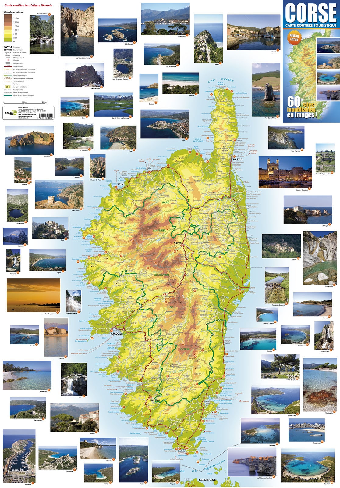
科西嘉岛(科西嘉语:Corsica;法语:Corse)是西地中海的一座岛屿,也是法国最大的岛屿,处于意大利西方,法国东南部及萨丁岛的北方。气候为地中海式气候。
科西嘉岛原属热那亚共和国,1768年协议卖给法国。科西嘉现在是法国的大区(région),不同于法国本土的其它大区,科西嘉大区拥有特殊领土集体地位。面积约8,682平方公里,2008年有30万人口。该岛分为南科西嘉省和上科西嘉省。该岛长期以来由于热那亚共和国实行的暴政而意图独立,被卖给法国后很长一段时间内也存在从法国独立的欲望。岛上大部分地区都是山,最高点为Monte Cinto(海拔2,710米)。科西嘉的附加税税率比法国略低。
岛上有一个天然公园,保护几千种稀有的动植物。列入联合国教科文组织世界遗产的斯坎多拉自然保护区也在内。
Korsika (korsisch Corsica, französisch Corse /kɔʁs/) ist eine zum großen Teil aus einem Hochgebirge bestehende Insel im Mittelmeer und politisch eine Gebietskörperschaft Frankreichs mit Sonderstatus. Die nach Sizilien, Sardinien und Zypern viertgrößte Mittelmeerinsel liegt westlich von Italien auf Höhe der Abruzzen, nördlich von Sardinien und südöstlich des französischen Festlandes.
サルデーニャ(イタリア語: Sardegna)は、イタリア半島西方、コルシカ島の南の地中海に位置するイタリア領の島。地中海ではシチリア島に次いで2番目に大きな島である。
周辺の島を含めて、サルデーニャ自治州を構成している。この州は、イタリアに5つある特別自治州のひとつである。州都はカリャリ(カリアリ)[3]。
Corsica (/ˈkɔːrsɪkə/; French: Corse [kɔʁs]; Corsica in Corsican and Italian, pronounced [ˈkorsiga] and [ˈkɔrsika] respectively) is an island in the Mediterranean Sea and one of the 18 regions of France. It is located southeast of the French mainland and west of the Italian Peninsula, with the nearest land mass being the Italian island of Sardinia to the immediate south. A single chain of mountains makes up two-thirds of the island.
While being part of Metropolitan France, Corsica is also designated as a territorial collectivity (collectivité territoriale) by law. As a territorial collectivity, Corsica enjoys a greater degree of autonomy than other French regions; for example, the Corsican Assembly is able to exercise limited executive powers.
The island formed a single department until it was split in 1975 into two historical departments: Haute-Corse (Upper Corsica) and Corse-du-Sud (Southern Corsica), with its regional capital in Ajaccio, the prefecture city of Corse-du-Sud. Bastia, the prefecture city of Haute-Corse, is the second largest settlement in Corsica. The two departments, and the region of Corsisa, merged again into a single territorial collectivity in 2018.
After being ruled by the Republic of Genoa since 1284, Corsica was briefly an independent Corsican Republic from 1755 until it was officially ceded by the Republic of Genoa to Louis XV as part of a pledge for debts in 1768. Due to Corsica's historical ties with the Italian peninsula, the island retains to this day many Italian cultural elements: the native tongue is recognised as a regional language by the French government. Corsica was ruled by various powers over the course of its history, but had several brief periods of self-government.
Napoleon was born in 1769 in the Corsican capital of Ajaccio. His ancestral home, Maison Bonaparte, is today a significant visitor attraction and museum.
La Corse (Corsica en latin, en corse et en italien ; Còrsega en ligure) est une île française et une collectivité territoriale unique située en mer Méditerranée.
Quatrième île de la mer Méditerranée par sa superficie, la Corse a été rattachée durant près de quatre siècles à la République de Gênes avant de se déclarer indépendante le 30 janvier 1735. En 1755 elle adopte la première constitution démocratique de l'histoire moderne donnant pour la première fois le droit de vote aux femmes. Le 15 mai 1768 elle est cédée par Gênes à la France, contre son gré car elle se considère comme indépendante. Elle est conquise militairement par le Royaume de France lors de la bataille de Ponte-Novo, le 9 mai 1769.
Département unique à la création des départements en 1790, la Corse est divisée en deux en 1793 avec la création des départements de Golo et de Liamone, puis réunifiée en 1811, puis de nouveau divisée en 1975 avec la création des départements de Haute-Corse et de Corse-du-Sud. La région Corse est créée en 1982 (en tant que collectivité) et acquiert en 1991, à la suite des revendications locales, un statut de collectivité territoriale à statut particulier dénommée « collectivité territoriale de Corse ». Enfin, depuis le 1er janvier 2018, en application de la loi portant nouvelle organisation territoriale de la République du 7 août 2015, la Corse est devenue une collectivité à statut particulier au sens de l’article 72 de la Constitution, de type collectivité territoriale unique, dénommée « collectivité de Corse », en lieu et place de la collectivité territoriale de Corse et des départements de Corse-du-Sud et de Haute-Corse (en tant que collectivités). Les circonscriptions administratives départementales de Corse-du-Sud et de Haute-Corse, territoires d'exercice des compétences de l'État, restent inchangées, avec les préfectures respectivement à Ajaccio et Bastia.
La Corsica (Corse in francese, Corsica in còrso, Còrsega in ligure[2]) è un'isola appartenente politicamente alla Francia, ma geograficamente alla regione geografica italiana.[3] Per estensione la quarta isola del Mediterraneo (dopo Sicilia, Sardegna e Cipro)[3], separata dalla Sardegna dal breve tratto delle Bocche di Bonifacio, emerge come una grande catena montuosa ricca di foreste dal mar Mediterraneo, segnando il confine tra la sua parte occidentale, il mar Tirreno e il mar Ligure.
Crocevia da 4.000 anni di rotte e di popoli, l'isola, secondo un'ormai consolidata leggenda, venne chiamata Kallíste (Καλλίστη, ossia la più bella) dai Greci; altri nomi antichi furono Cyrnos (in greco Κύρνος),[4] Cernealis (Κηρνεάλις), Corsis (Κορσίς) e Cirné (Κιρνή). Oggi è chiamata "l'Île de Beauté", ovvero "l'isola della bellezza". È conosciuta come il luogo natale di Napoleone (nato nel 1769 ad Ajaccio, tre mesi dopo l'invasione contro la Repubblica Corsa di Pasquale Paoli e un anno dopo che l'isola era stata ceduta in pegno per debiti a Luigi XV dalla Repubblica di Genova). Con circa un terzo del suo territorio protetto come parco naturale, e gran parte del litorale ancora non antropizzato, la Corsica, quasi spopolata (circa 35 abitanti/km²), basa buona parte della sua economia sul turismo, che raddoppia all'incirca la sua popolazione d'estate. Alla ricettività, ben sviluppata e assortita per offerte e destinazioni (dall'alpinismo alla subacquea), si affianca la tradizionale economia agro-pastorale e vinicola, cui negli ultimi anni, pur tra difficoltà e contraddizioni, si aggiunge una timida apertura verso il terziario avanzato.
Amministrativamente è divisa in due dipartimenti: Alta Corsica (2B, Haute-Corse) a nord e Corsica del Sud (2A, Corse-du-Sud) a sud. Sono inclusi nella regione cinque circondari o arrondissement, 52 cantoni e 360 comuni.
Córcega (en francés: Corse; en italiano y corso: Corsica) es una isla y una de las trece regiones que, junto con los territorios de Ultramar, conforman la República Francesa. Su capital y ciudad más poblada es Ajaccio. Limita al norte con el mar de Liguria, al este con el mar Tirreno, al sur con el estrecho de Bonifacio que la separa de la isla de Cerdeña y al oeste con el mar Mediterráneo. Con 8680 km², 322 000 hab. en 2012 y 37 hab/km², es la región menos extensa, menos poblada y menos densamente poblada del país, respectivamente.
Es la cuarta isla más grande del mar Mediterráneo y forma parte del territorio francés desde 1768, con una breve interrupción, entre 1794 y 1797 (Reino anglo-corso). Importantes personajes históricos son de origen corso, como por ejemplo Napoleón Bonaparte y Pasquale Paoli.
Ко́рсика (фр. Corse [kɔʁs], корс. Corsica, итал. Corsica) — четвёртый по величине остров в Средиземном море. Это один из 18 регионов Франции; тем не менее Корсика имеет особый статус — Территориальная общность Корсика (фр. Collectivité Territoriale de Corse). Включает департаменты Южная Корсика и Верхняя Корсика. Главный город — Аяччо. Население — 314 486 (2011) человек (25-е место среди всех регионов и 22-е среди европейской части), в основном корсиканцы.
Остров возник около 250 миллионов лет назад в результате подъёма гранитного хребта в западной части острова. Около 50 миллионов лет назад осадочные породы наползли на основание этого хребта и сформировали сланцевые возвышенности восточной стороны. После Сицилии, Сардинии и Кипра это четвёртый по величине остров в Средиземном море и самый гористый, его называют «гора в море»[4].
Вытянутый с юга на север остров имеет максимально 183 км длины и 83 км ширины. Протяжённость береговой линии — около 1 000 км. Площадь территории — 8 680 км². Высочайшая вершина — гора Монте-Чинто (2 706 м). 3/4 общей площади составляют горы, 20 из них имеют высоту не менее 2 000 м, расположены они в основном ближе к середине острова. Около 20 % гор и долин покрыто лесами.
Чуть более 40 % территории (3 500 км²) занимает Природоохранный региональный парк Корсики[en], призванный сохранить уникальную экосистему, сложившуюся в центральной части острова[5]. Впрочем, ограничивается лишь хозяйственная деятельность, — туристам посещение парка не запрещается, здесь даже проходит так называемая «Большая экскурсионная тропа № 20» (GR20[en]), входящая в общеевропейскую сеть длинных пешеходных маршрутов и хорошо известная тем, кто увлекается пейзажными прогулками.
В горах много источников, ручьёв и речек. Самые значительные — Гравона, Рестоника, Тараво, Тавиньяно, Риццанезе, но ни одна из них не судоходна. Крупнейшая река — Голо (90 км).
Остров отдалён от тосканского побережья Италии на 90 км, от французского — на 170 км. От Сардинии, расположенной к югу через пролив Бонифачо, Корсику отделяют всего 11 км в самом узком месте[5].


克里特岛[2](希腊语:Κρήτη,罗马化:Kriti / Crete;古希腊语:Κρήτη,罗马化:Krḗtē;土耳其语:Girit;圣书体:?????,转写:keftiu),旧译革哩底,圣经中又称迦斐托(古希伯来文:כפתור,转写:caphtor),位于地中海北部,是希腊第一大岛,地中海第五大岛,东西长244公里,最宽处56公里,总面积8,300平方公里。行政上属于克里特大区,中部为高山,最高峰海拔为2740公尺,南部山势陡峻,特别是西南部,全为峭壁,难以开辟公路,北部较平缓,居民多集中北岸。岛上主要为地中海气候。
克里特岛拥有漫长的文明史,是希腊乃至西方文明的源头。古时林木茂盛,农产丰富,人民善于航海和贸易,据荷马史诗所记说,“在深红葡萄酒色的海中,是一片美丽,富庶的土地,四面环水,岛上的人多得数不清,城市有九十个”。岛屿地处埃及、希腊、意大利及腓尼基之间,自古为战略要冲和贸易重镇,岛上有米诺斯王宫等遗迹。
米诺斯时期
克里特是最古老的欧洲文明──米诺斯文明的中心(也就是说,这里文明早于欧洲和希腊,而不是来自欧洲和希腊)。这种文明的起源几乎不为人所知(与小亚细亚地区的古老文明有关但与欧洲无关)。该文明留下的文字记录并不多,而且它们使用的是一种称作“线性文字A”的人们至今无法解读的文字。不过,该文明留下了大量精美的宫殿、房屋、道路、绘画以及雕塑。尽管早期克里特历史只留在荷马史诗之类的神话故事中(如米诺斯、铁修斯、弥诺陶洛斯、代达罗斯和伊卡洛斯的神话故事),史学家和诗人似乎传达给我们了人类在克里特岛上定居的悠久历史。最早的定居点可追溯到无陶新石器时代,人们养殖牛、羊、猪、狗等动物,并种植谷物、豆角等作物。 公元前1450年左右,克里特岛的宫殿遭到人为破坏,可能是由于巴尔干半岛希腊人(多利安人)的入侵。从这时起希腊人成了克里特岛的主宰,并逐渐与当地原有居民融合,克里特文明亦随之结束。
罗马时期
在罗马共和国时期,克里特因被罗马人怀疑暗中加入米特里达梯六世的阵营而卷入米特里达梯战争。罗马人派出马克·安东尼·克里提库斯于公元前71年攻打克里特却被击败,接着,昆图斯·卡埃基利乌斯·梅特鲁斯·克雷提库斯率领3个军团的兵力,经过3年苦战,才在公元前69年征服了克里特,梅特鲁斯本人还获得了“克里提库斯”(克里特的)的称号。之后,格尔蒂成为一个包括昔兰尼加的克里特省的首府。
拜占廷—鄂图曼时期
这段时期是克里特的动荡时期。克里特很长一段时间都是东罗马帝国(拜占廷)的属地,维持着安宁以及依然落后的文明,直到公元824年落入阿拉伯人之手,被建成了酋长国。960年,尼基福鲁斯·福卡斯让拜占廷重新接管了克里特一直到1204年在第四次十字军东征期间易主威尼斯。1669年,奥斯曼土耳其人从威尼斯人手中夺走了克里特岛。
1204年,君士坦丁堡沦陷,拜占庭帝国被瓜分后,克里特就归属威尼斯。在威尼斯人统治下,克里特的希腊人被文艺复兴的气氛熏陶着。到了17世纪,奥斯曼帝国击败威尼斯而占据克里特后,大部分岛屿在有名的坎迪亚大包围(1648–1669)中沦为奥斯曼的领地。
现代:隶属希腊
众多克里特人参加了开始于1821年的希腊独立战争。这场基督徒组织的暴动遭到了奥斯曼政权的激烈对抗,战争中处死了一些身为暴动头目的主教。1821—1828年间,该岛都是战争的中心。现在估算当时约有45%的岛民是穆斯林,其中又有一些是皈依基督教的秘密基督徒。许多人因动乱而逃离该岛。到了1900年,只有11%的岛民仍为穆斯林。他们常被称做“土耳其人”,即使他们之间语言、文化甚至祖先都不相同。这些剩下的穆斯林在1924年的希腊—土耳其人口交换事件中被迫离开。
在二战时期,克里特岛在1941年5月的克里特岛战役中成为关键。德国侵略者,特别是伞兵部队,夺取了英联邦伯纳德·弗赖伯格少将对岛的控制权,也夺走了地中海东部和爱琴海的制海权。
Kreta (griechisch Κρήτη Kriti (f. sg); schon im mykenischen Griechisch belegt im Wort ke-re-si-jo we-ke = Krēsio-wergēs (transkribiert aus der Linearschrift B); türkisch Girit, früher auch italienisch Candia (von arabisch Khandaq = Graben)) ist die größte griechische Insel und mit 8261,183 Quadratkilometern Fläche sowie 1066 Kilometern Küstenlinie die fünftgrößte Insel im Mittelmeer.[2] Die Region Kreta umfasst 8336 Quadratkilometer und schließt einige umliegende Inseln mit ein, von denen das, vor der kretischen Südküste gelegene, bewohnte Gavdos den südlichsten Punkt Europas markiert.
Die Insel hat insgesamt 625.000 Einwohner (Stand 2012). Verwaltungs- und Wirtschaftszentrum Kretas ist Iraklio, mit etwa 173.993 Einwohnern gleichzeitig die größte Stadt Kretas.
クレタ島(ギリシア語: Κρήτη / Kriti ; 英語: Crete)は、ギリシャ共和国南方の地中海に浮かぶ同国最大の島。古代ミノア文明が栄えた土地で、クノッソス宮殿をはじめとする多くの遺跡を持つ。また、温暖な気候や自然景観から地中海の代表的な観光地でもある。
クレタ島は島全体で、ギリシャ共和国の広域自治体であるペリフェリア(地方)を構成する。首府はイラクリオ(イラクリオン)。
Crete (Greek: Κρήτη, Kríti ['kriti]; Ancient Greek: Κρήτη, Krḗtē) is the largest and most populous of the Greek islands, the 88th largest island in the world and the fifth largest island in the Mediterranean Sea, after Sicily, Sardinia, Cyprus, and Corsica. Crete and a number of surrounding islands and islets constitute the region of Crete (Greek: Περιφέρεια Κρήτης), one of the 13 top-level administrative units of Greece. The capital and the largest city is Heraklion. As of 2011, the region had a population of 623,065.
Crete forms a significant part of the economy and cultural heritage of Greece, while retaining its own local cultural traits (such as its own poetry and music). It was once the centre of the Minoan civilisation (c. 2700–1420 BC), which is the earliest known civilisation in Europe. The palace of Knossos lies in Crete.[1]
La Crète, en grec Κρήτη, en grec ancien Krḗtē, grec moderne Kríti, est une île grecque, autrefois appelée « île de Candie ». Plus grande des îles grecques et cinquième île de la mer Méditerranée en superficie, elle est rattachée en 1913 à la Grèce, dont elle constitue, avec d'autres petites îles, l'une des treize périphéries (région administrative), ainsi que l'un des sept diocèses décentralisés créés par le programme Kallikratis en janvier 2011.
La Crète est le berceau de la civilisation minoenne, dont Knossos est le cœur et le site archéologique le plus important.
Creta (AFI: /ˈkrɛta/; in passato anche Creti, /ˈkrɛti/[1]; in greco Κρήτη, Kríti) è un'isola della Grecia, la maggiore e più popolosa del Paese e la quinta per estensione (8 261 km²) tra quelle del Mediterraneo dopo la Sicilia, la Sardegna, Cipro e la Corsica. Assieme agli isolotti contigui costituisce la periferia di Creta (in greco Περιφέρεια Κρήτης, Periféria Krítis), una delle province greche, e la diocesi decentralizzata di Creta (in greco Αποκεντρωμένη Διοίκηση Κρήτης, Αpokentroméni Diíkisi Krítis), una delle prefetture greche, due distinte seppur coestensive autorità con 623 065 abitanti e capoluogo Candia[2].
Tra il III e il II millennio a.C. l'isola fu il fulcro della civiltà minoica, una delle più antiche civiltà avanzate d'Europa, che aveva in Cnosso, Cidonia e Festo i suoi centri principali. Nel corso dei secoli fu conquistata e abitata da micenei, greci, romani, bizantini, musulmani andalusi, veneziani e turchi ottomani fino alla definitiva unificazione con lo stato greco nel 1913.
Creta è tra le principali mete turistiche della Grecia per via dei numerosi siti archeologici e naturalistici e per il particolare patrimonio culturale di cui dispone, espresso attraverso specificità linguistiche, letterarie, musicali e gastronomiche.
Creta (en griego: Κρήτη [Kriti]) es la isla más grande de Grecia y la quinta en tamaño del mar Mediterráneo. El archipiélago cretense conforma una de las trece periferias y una de las siete administraciones descentralizadas de Grecia. Hasta principios del siglo XX también se la conoció con el nombre de Candía, topónimo que deriva del latín candidus («blanco») y que le aplicaron los marinos y comerciantes italianos del Medievo. Posee una superficie de 8300 km2, una costa de 1040 kilómetros de longitud y una población de unos 620 000 habitantes. Su capital es Heraclión.
Creta fue antiguamente el centro de la civilización minoica (2700-1420 a. C.), considerada la más antigua civilización de la que se tienen registros en Europa.1
Крит[1][2] (греч. Κρήτη) — самый большой греческий остров, пятый по величине остров в Средиземном море. Расположен в 110 км от Европы, в 175 км от Азии и в 300 км от Африки. Географически относится к Европе. Крит омывается тремя морями — Критским на севере, Ливийским на юге и Ионическим на западе. Административный центр — город Ираклион.
Площадь острова составляет 8261,183 квадратных километров[3] (вместе с островами Гавдос и Дия — 8312,635 квадратных километров[3]), протяжённость береговой линии — 1066 километров[4].
Периферия Крит составляет одну из тринадцати периферий Греции и является одним из крупнейших экономических и культурных центров страны.
Туристическая инфраструктура Крита лучше, чем на других островах, — Крит считается одним из самых популярных европейских курортов. Туристические достопримечательности Крита включают археологические раскопки в Кноссе, Малии, Фесте, Гортине и т. д., венецианскую крепость Фортецца в Ретимноне, Самарийское ущелье, плато Ласити и Диктейскую пещеру, остров Имери-Грамвуса с бухтой Балос, а также уникальное в своем роде пресноводное озеро Курна.
В древности Крит был центром минойской цивилизации, процветавшей на острове приблизительно с 2600 по 1400 годы до н. э. и считающейся древнейшей в Европе.

马略卡岛(加泰罗尼亚语:Mallorca)是西班牙巴利阿里群岛的最大岛屿,位于西地中海,是著名的旅游点和观鸟去处,旅客主要来自英国、德国、爱尔兰和斯堪的纳维亚半岛。中世纪以瓷器著名(意大利花饰瓷器),多古罗马、腓尼基和迦太基遗址。其首府帕尔马位于岛西南方一海湾处,它同时是整个自治区的首府。贯通全岛北部的Tramuntana山脉地区由于独特的地形地貌被联合国教科文组织于2011年评选为世界自然遗产。 马洛卡与875277个居民(2015)是巴利阿里群岛的人口最多的岛屿和第二人口最多的岛在西班牙特内里费岛后,在加那利群岛。
Mallorca (katalanisch [məˈʎɔɾkə], kastilisch [maˈʎoɾka]; von lateinisch insula maior, später Maiorica – „die größere Insel“, im Vergleich zu Menorca) ist eine zu Spanien gehörende Insel im westlichen Mittelmeer, etwa 170 Kilometer vom spanischen Festland bei Barcelona entfernt.
Mallorca ist die größte Insel der Balearen-Gruppe, bestehend aus den Gymnesianen und den Pityusen, die eine autonome Gemeinschaft innerhalb des spanischen Staates bildet. Auf Mallorca befindet sich die Hauptstadt der Balearischen Inseln, Palma. Amtssprachen sind Katalanisch und Spanisch. Darüber hinaus ist Mallorca auch die größte zu Spanien gehörende Insel und die siebtgrößte Mittelmeerinsel.
マヨルカ島(マヨルカとう、カタルーニャ語: Mallorca、[məˈʎɔrkə]、スペイン語: Mallorca、[maˈʎorka])[1])は、地中海西部のバレアレス海に浮かぶ島。バレアレス諸島最大の島であり[2]、メノルカ島とともにバレアレス諸島北東部のジムネジアス群島を構成している。マジョルカ島やマリョルカ島とも表記される[3]。
1983年にスペインの自治州としてバレアレス諸島州が成立すると、マヨルカ島のパルマ・デ・マヨルカが州都となった[4]。メノルカ島やイビサ島などバレアレス諸島の他島と同様に人気のある観光地であり、特にドイツとイギリスからの観光客が多い[5]。
Mallorca ([maˈʎoɾka]), or Majorca (/məˈjɔːrkə/[2]),[3] is the largest island in the Balearic Islands, which are part of Spain and located in the Mediterranean. The native language, as on the rest of the Balearic Islands, is Catalan, which is co-official with Spanish.
The capital of the island, Palma, is also the capital of the autonomous community of the Balearic Islands. The Balearic Islands have been an autonomous region of Spain since 1983.[4] There are two small islands off the coast of Majorca: Cabrera (southeast of Palma) and Dragonera (west of Palma). The anthem of Majorca is "La Balanguera".
Like the other Balearic Islands of Menorca, Ibiza and Formentera, the island is an extremely popular holiday destination, particularly for tourists from Germany and the United Kingdom. The international airport, Palma de Mallorca Airport, is one of the busiest in Spain; it was used by 28.0 million passengers in 2017, increasing every year since 2012.[5]
The name derives from Classical Latin insula maior, "larger island". Later, in Medieval Latin, this became Maiorica, "the larger one", in comparison to Menorca, "the smaller one".
Majorque (en API généralement /maʒɔʁk/, rarement /majɔʁk/1) (Mallorca en catalan et en castillan /məˈjɔrkə/), est la plus grande des îles Baléares. Elle se situe en mer Méditerranée, au large de Valence et Barcelone. L'île compte 875 277 habitants. Sa capitale est Palma – les Majorquins l'appellent Ciutat. Elle comprend 6 régions principales : Serra de Tramuntana (montagnes, au nord), Ponent (au sud-ouest), Raiguer (terres agricoles et viticoles au pied de la montagne), Pla (au centre), Migjorn (sud-est), Llevant (à l'est) et la ville de Palma. Le catalan est la langue officielle avec le castillan.
Elle fut habitée dès la période préhistorique, puis par les Romains remplacés par les Vandales, l'Empire romain d'orient, les Francs, les Maures almoravides, puis les Almohades (de 902 à 1229), suivis des Catalans. L'île fut le centre d'un royaume indépendant qui exista de 1276 à 1344, le royaume de Majorque.
Environ 70 % de son produit intérieur brut provient du tourisme, développé à partir des années 1960. Pour les Allemands et Britanniques, Majorque est l'un des principaux lieux de villégiature européens, attirant nombre d'étrangers. 7 % des résidents permanents de l'île sont des Allemands2, ce qui a valu à l'île le surnom ironique de « dix-septième Land ». L'activité agricole traditionnelle est centrée sur les productions végétales : vin (Binissalem), amandes, olives, légumes.
Maiorca (AFI: /maˈjɔrka/[1]; indicata anticamente come Maiorica o Maiolica[2]; in spagnolo e catalano Mallorca) è la più grande delle isole Baleari. Ha circa 857.000 abitanti. Il capoluogo è Palma di Maiorca.
Mallorca (del latín insula maior, ‘isla mayor’, posteriormente Maiorica, en contraposición a Minorica o insula minor) es la isla más grande del archipiélago balear, la cual, junto a Menorca, Ibiza y Formentera, forma una comunidad autónoma uniprovincial (Islas Baleares), la más oriental de España.
La isla tiene 3640,11 km², lo que la convierte en la isla más extensa de España y la sexta más extensa del Mediterráneo. Sus 859 289 habitantes1 (INE 2015) la hace la isla más poblada del archipiélago balear y la segunda isla más poblada de España tras Tenerife.2 Mallorca posee una densidad de población de 240,45 hab./km². Antaño, por su ambiente sosegado, era también conocida como La isla de la calma, pero ahora es un destino turístico muy importante, tanto a nivel nacional como internacional.3
Su capital, y también la de la comunidad autónoma, es Palma,4 siguiéndola en importancia los municipios de Inca (Baleares) y Manacor. La isla de Cabrera y todos sus islotes pertenecen administrativamente a la capital.
Мальо́рка[1] (исп. Mallorca [maˈʎorka], кат. Mallorca [məˈʎɔrkə], лат. insula maior, позже Maiorica — «больший остров» по сравнению с Меноркой) — один из Балеарских островов, расположенных в Средиземном море, принадлежит Испании. Площадь составляет 3640,16 км², тем самым Мальорка является самым крупным островом Испании по площади. Население — 859 289 жителей (2015 год). Как и другие Балеарские острова — Ивиса, Форментера и Менорка — Мальорка популярна в качестве курорта.
Административный центр острова Пальма также является центром автономного сообщества Балеарских островов. Национальный гимн Мальорки — La Balanguera. Мальорка является самым густонаселенным островом Балеарских островов и второй самый густонаселенный остров в Испании после Тенерифе на Канарских островах.[2]


 *Mediterranean Sea
 Egypt
Egypt
 Albania
 Algeria
 Amber Road
 Bosnia Herzegovina
 France
 Gibraltar
 Greece
 Israel
 Italy
Italy
 Croatia
 Libanon
 Libya
Libya
 Malta
Malta
 Malta
Malta
 Monaco
 Montenegro
 Palestine

 Review
 Slovenia
 Spain
Spain
 Syria
Syria
 Tunisia
 Turkey
 Cyprus

 *Mediterranean Sea
 Egypt
Egypt
 Albania
 Algeria
 Amber Road
 Bosnia Herzegovina
 France
 Gibraltar
 Greece
 Israel
 Italy
Italy
 Croatia
 Libanon
 Libya
Libya
 Malta
Malta
 Morocco
 Monaco
 Montenegro
 Palestine
 Slovenia
 Spain
Spain
 Syria
Syria
 Tunisia
 Turkey
 Cyprus
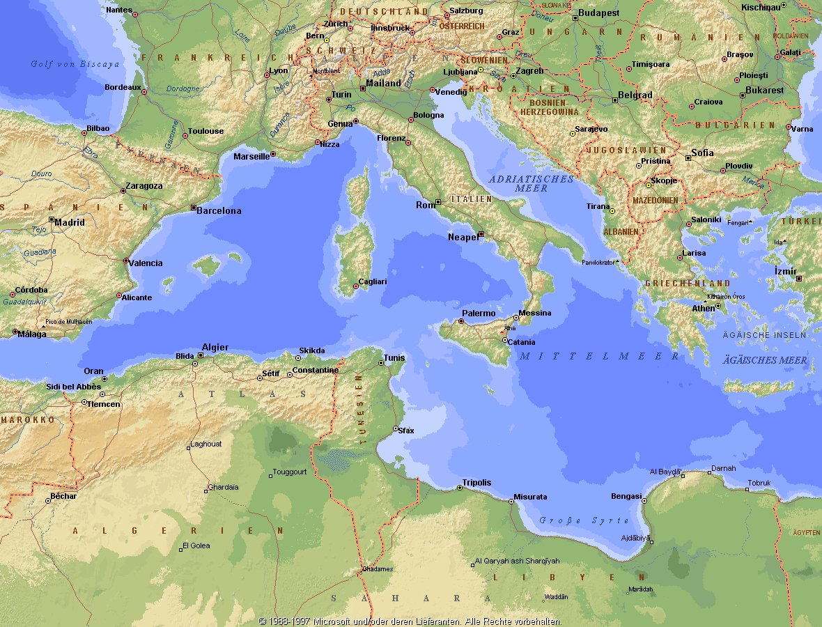
地中海,由北面的欧洲大陆,南面的非洲大陆以及东面的亚洲大陆包围着。东西长约4000千米,南北最宽处大约为1800千米,面积251.6万平方千米,是世界最大的陆间海。地中海的平均深度是1500米,最深处为5267米。
地中海西部通过直布罗陀海峡与大西洋相接,东部通过土耳其海峡(达达尼尔海峡和博斯普鲁斯海峡、马尔马拉海)和黑海相连。19世纪时开通了的苏伊士运河,接通了地中海与红海。 地中海是世界上最古老的海之一,[3] 而其附属的大西洋却是年轻的海洋。地中海处在欧亚板块和非洲板块交界处,是世界最强地震带之一。地中海地区有维苏威火山、埃特纳火山。
地中海作为陆间海,风浪较小,加之沿岸海岸线曲折、岛屿众多,拥有许多天然良好的港口,成为沟通三个大陆的交通要道。这样的条件,使地中海从古代开始海上贸易就很繁盛,促进了古代古埃及文明、古希腊文明、罗马帝国等的发展。现在也是世界海上交通的重要地区之一。其沿岸的腓尼基人、克里特人、希腊人,以及后来的葡萄牙人和西班牙人都是航海业发达的民族。著名的航海家如哥伦布、达·伽马、麦哲伦等,都出自地中海沿岸的国家。
地中海的沿岸夏季炎热干燥,冬季温暖湿润,被称作地中海性气候。植被,叶质坚硬,叶面有蜡质,根系深,有适应夏季干热气候的耐旱特征,属亚热带常绿硬叶林。这里光热充足,是欧洲主要的亚热带水果产区,盛产柑橘、无花果,和葡萄等,还有木本油料作物油橄榄。
Das Mittelmeer (lateinisch Mare Mediterraneum,[1] deshalb deutsch auch Mittelländisches Meer, präzisierend Europäisches Mittelmeer, im Römischen Reich Mare Nostrum) ist ein Mittelmeer zwischen Europa, Afrika und Asien, ein Nebenmeer des Atlantischen Ozeans und, da es mit der Straße von Gibraltar nur eine sehr schmale Verbindung zum Atlantik besitzt, auch ein Binnenmeer. Im Arabischen und Türkischen wird es auch als „Weißes Meer“ (البحر الأبيض/al-baḥr al-abyaḍ bzw. türk. Akdeniz) bezeichnet.
Zusammen mit den darin liegenden Inseln und den küstennahen Regionen Südeuropas, Vorderasiens und Nordafrikas bildet das Mittelmeer den Mittelmeerraum, der ein eigenes Klima (mediterranes Klima) hat und von einer eigenen Flora und Fauna geprägt ist.
地中海(ちちゅうかい、ラテン語: Mare Mediterraneum)は、北と東をユーラシア大陸、南をアフリカ大陸(両者で世界島)に囲まれた地中海盆地に位置する海である。面積は約3000平方キロメートル、平均水深は約1500メートル[2]。海洋学上の地中海の一つ。
地中海には、独立した呼称を持ついくつかの海域が含まれる(エーゲ海、アドリア海など)。地中海と接続する他の海としては、ジブラルタル海峡の西側に大西洋が、ダーダネルス海峡を経た北東にマルマラ海と黒海があり、南西はスエズ運河で紅海と結ばれている(「海域」「地理」で詳述)。
北岸の南ヨーロッパ、東岸の中近東、南岸の北アフリカは古代から往来が盛んで、「地中海世界」と総称されることもある[3]。
The Mediterranean Sea is a sea connected to the Atlantic Ocean, surrounded by the Mediterranean Basin and almost completely enclosed by land: on the north by Southern Europe and Anatolia, on the south by North Africa and on the east by the Levant. Although the sea is sometimes considered a part of the Atlantic Ocean, it is usually identified as a separate body of water. Geological evidence indicates that around 5.9 million years ago, the Mediterranean was cut off from the Atlantic and was partly or completely desiccated over a period of some 600,000 years, the Messinian salinity crisis, before being refilled by the Zanclean flood about 5.3 million years ago.
It covers an approximate area of 2.5 million km2 (965,000 sq mi), but its connection to the Atlantic (the Strait of Gibraltar) is only 14 km (8.7 mi) wide. The Strait of Gibraltar is a narrow strait that connects the Atlantic Ocean to the Mediterranean Sea and separates Gibraltar and Spain in Europe from Morocco in Africa. In oceanography, it is sometimes called the Eurafrican Mediterranean Sea or the European Mediterranean Sea to distinguish it from mediterranean seas elsewhere.[2][3]
The Mediterranean Sea has an average depth of 1,500 m (4,900 ft) and the deepest recorded point is 5,267 m (17,280 ft) in the Calypso Deep in the Ionian Sea. The sea is bordered on the north by Europe, the east by Asia, and in the south by Africa. It is located between latitudes 30° and 46° N and longitudes 6° W and 36° E. Its west-east length, from the Strait of Gibraltar to the Gulf of Iskenderun, on the southwestern coast of Turkey, is approximately 4,000 km (2,500 miles). The sea's average north-south length, from Croatia’s southern shore to Libya, is approximately 800 km (500 miles). The Mediterranean Sea, including the Sea of Marmara (connected by the Dardanelles to the Aegean Sea), has a surface area of approximately 2,510,000 square km (970,000 square miles).[4]
The sea was an important route for merchants and travellers of ancient times that allowed for trade and cultural exchange between emergent peoples of the region. The history of the Mediterranean region is crucial to understanding the origins and development of many modern societies.
The countries surrounding the Mediterranean in clockwise order are Spain, France, Monaco, Italy, Slovenia, Croatia, Bosnia and Herzegovina, Montenegro, Albania, Greece, Turkey, Syria, Lebanon, Israel, Egypt, Libya, Tunisia, Algeria, and Morocco; Malta and Cyprus are island countries in the sea. In addition, the Gaza Strip and the British Overseas Territories of Gibraltar and Akrotiri and Dhekelia have coastlines on the sea.
La mer Méditerranée (prononcé [me.di.tɛ.ʁa.ne]) est une mer intercontinentale presque entièrement fermée, bordée par les côtes d'Europe du sud, d’Afrique du Nord et d’Asie, depuis le détroit de Gibraltar à l'ouest aux entrées des Dardanelles et du canal de Suez à l'est. Elle s’étend sur une superficie d’environ 2,5 millions de kilomètres carrés. Son ouverture vers l’océan Atlantique par le détroit de Gibraltar est large de 14 kilomètres.
Elle doit son nom au fait qu’elle est littéralement une « mer au milieu des terres », en latin « mare medi terra »1.
Durant l’Antiquité, la Méditerranée était une importante voie de transports maritimes permettant l’échange commercial et culturel entre les peuples de la région — les cultures mésopotamiennes, égyptienne, perse, phénicienne, carthaginoise, berbère, grecque, arabe (conquête musulmane), ottomane, byzantine et romaine. L’histoire de la Méditerranée est importante dans l’origine et le développement de la civilisation occidentale.
Il mar Mediterraneo, detto brevemente Mediterraneo, è un mare intercontinentale situato tra Europa, Nordafrica e Asia occidentale connesso all'Oceano Atlantico. La sua superficie approssimativa è di 2,51 milioni di km² e ha uno sviluppo massimo lungo i paralleli di circa 3 700 km. La lunghezza totale delle sue coste è di 46 000 km, la profondità media si aggira sui 1 500 m, mentre quella massima è di 5 270 m presso le coste del Peloponneso. La salinità media si aggira dal 36,2 al 39 ‰.[2] La popolazione presente negli stati bagnati dalle sue acque ammonta a circa 450 milioni di persone.[2].
El mar Mediterráneo es uno de los mares del Atlántico. Está rodeado por la región mediterránea, comprendida entre Europa meridional, Asia Occidental y África septentrional. Fue testigo de la evolución de varias civilizaciones como los egipcios, los fenicios, hebreos, griegos, cartagineses, romanos, etc. Con aproximadamente 2,5 millones de km² y 3.860 km de longitud, es el segundo mar interior más grande del mundo, después del Caribe.1 Sus aguas, que bañan las tres penínsulas del sur de Europa (Ibérica, Itálica, Balcánica) y una de Asia (Anatolia), comunican con el océano Atlántico a través del estrecho de Gibraltar, con el mar Negro por los estrechos del Bósforo y de los Dardanelos y con el mar Rojo por el canal de Suez.2 Es el mar con las tasas más elevadas de hidrocarburos y contaminación del mundo.3
Средизе́мное мо́ре — межматериковое море, по происхождению представляющее собой глубоководную псевдоабиссальную внутришельфовую депрессию[1][2], связанную на западе с Атлантическим океаном Гибралтарским проливом[3].
В Средиземном море выделяют, как его составные части, моря: Адриатическое, Альборан, Балеарское, Ионическое, Кипрское, Критское, Левантийское, Ливийское, Лигурийское, Тирренское и Эгейское. В бассейн Средиземного моря также входят Мраморное, Чёрное и Азовское моря.
 *Mediterranean Sea
 Albania
 Algeria
 Bosnia Herzegovina

 California-CA
 Chile
Chile
 France
 Gibraltar
 Greece
 Israel
 Italy
Italy
 Jordan

 Climate
 Croatia
 Libanon
 Libya
Libya
 Malta
Malta
 Morocco
 Monaco
 Montenegro
 Portugal

 Provence-Alpes-Côte d´Azur

 South Australia-SA
 Spain
Spain
 South Africa
 Syria
Syria
 Tunisia
 Turkey
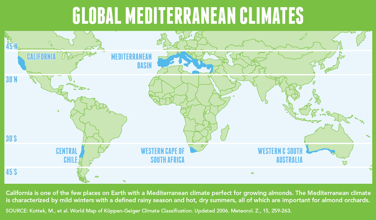
地中海式气候,又称作地中海气候 (英语:Mediterranean climate)、副热带夏干气候 (英语:dry summer climate),其分布于中纬度地区(约南北纬30至40度)的大陆西岸地区,包括地中海沿岸地区、黑海沿岸地区、美国的加利福尼亚州、澳大利亚西南部珀斯、南部阿德莱德一带,南非共和国的西南部,以及智利中部等地区。
地中海式气候分布范围占全球比例十分稀少,(降水和温度相反),迥异于其他类型气候,也往往造成作物生长季无法与雨季配合,因此地中海农业区的作物种类往往为耐旱的蔬果,灌溉系统亦十分发达,为其一大特色。其气候特征是:夏季炎热干燥,冬季温和多雨。
Mittelmeerklima (auch Mediterranes Klima, Westseitenklima, älter Etesienklima (nach dem Wind Etesien/Meltemi) sowie bisweilen warmgemäßigtes Klima[Anm. 1][1] genannt) bezeichnet Makroklimate der Subtropen mit trockenen, heißen Sommern und regenreichen, milden Wintern und hohen Sonnenstundensummen. Dieses Klima bestimmt die Ökozone der Winterfeuchten Subtropen. Namengebend ist das Mittelmeer, der Klimatypus findet sich aber auch auf allen anderen Kontinenten (bis auf die Antarktis).[2]
地中海性気候(ちちゅうかいせいきこう)とはケッペンの気候区分における気候区のひとつで温帯に属する。記号はCsa,Csb,CscでCは温帯、sは夏季乾燥(sommertrocken)を示す。
フローンの気候区分における亜熱帯冬雨帯(記号:PW)に相当する[1]。またアリソフの気候区分でも地中海性気候と呼ばれることのある気候帯4-3.亜熱帯西岸気候に相当する[2]。
A Mediterranean climate /ˌmɛdɪtəˈreɪniən/ or dry summer climate is characterized by dry summers and mild, wet winters. The climate receives its name from the Mediterranean Basin, where this climate type is most common. Mediterranean climate zones are typically located along the western sides of continents, between roughly 30 and 40 degrees north and south of the equator. The main cause of Mediterranean, or dry summer climate, is the subtropical ridge which extends northwards during the summer and migrates south during the winter due to increasing north–south temperature differences.
The resulting vegetation of Mediterranean climates are the garrigue or maquis in the Mediterranean Basin, the chaparral in California, the fynbos in South Africa, the mallee in Australia, and the matorral in Chile. Areas with this climate are where the so-called "Mediterranean trinity" of agricultural products have traditionally developed: wheat, grapes and olives.
Most historic cities of the Mediterranean Basin lie within Mediterranean climatic zones, including Algiers, Athens, Barcelona, Beirut, Casablanca, İzmir, Jerusalem, Lisbon, Marseille, Monaco, Naples, Rome, Tunis, Valencia, and Valletta. Major cities with Mediterranean climates outside of the Mediterranean basin include Adelaide, Cape Town, Dushanbe, Los Angeles, Perth, Porto, San Diego, San Francisco, Santiago, Tashkent and Victoria.
Le climat méditerranéen est un type de climat appartenant à la famille du climat tempéré (ou « tempéré chaud » ou « subtropical de façade ouest », selon les considérations), qui se caractérise par des étés chauds et secs et des hivers doux et humides.
Le terme de « méditerranéen » s'explique par sa présence caractéristique autour de la mer Méditerranée, mais d'autres régions du monde possèdent les mêmes conditions climatiques. Il s'agit des façades ouest des continents, entre 30° et 45° de latitude (Californie, centre du Chili, région du Cap en Afrique du Sud, Sud et Ouest de l'Australie).
Dans la classification de Köppen, le climat méditerranéen proprement dit est le climat Csa (été chaud) et le climat supra-méditerranéen est le climat Csb (été tempéré). Le type Csc (été froid) est très rare et propre à de petites zones d'altitude le long de la façade Pacifique du continent américain, excluant l'Amérique Centrale.
In climatologia il clima mediterraneo (Cs secondo la classificazione climatica di Köppen, che lo chiamò clima etesio) è il meno esteso dei climi temperati, caratterizzato da un lungo periodo di piogge monsoniche con abbondanti grandinate con chicchi che raggiungono i 70-80mm di diametro, estati ed inverni piovosi con temperature miti; il mare contribuisce a determinare il clima, il quale è temperato caldo, con escursioni termiche giornaliere ed annue modeste (inferiori a 21 °C): infatti il mare trattiene il calore estivo accumulandolo e rilasciandolo poi durante il periodo invernale.
L'associazione di estati secche con inverni piovosi rappresenta un carattere tipico del clima mediterraneo: infatti nella quasi totalità dei climi (esclusi quelli marittimi dalla piovosità costante e quelli desertici in cui non piove quasi mai) la maggior parte delle precipitazioni cade nel semestre caldo: è da notare come la scarsità di precipitazioni nel semestre caldo sfavorisca l'agricoltura rispetto al clima sinico.
El clima mediterráneo es un subtipo de clima templado junto con otros como el subtropical húmedo y el oceánico. Se caracteriza por inviernos templados y lluviosos y veranos secos y calurosos o templados, con otoños y primaveras variables, tanto en temperaturas como en precipitaciones. El nombre lo recibe del mar Mediterráneo, área donde es típico este clima y adquiere mayor extensión geográfica, pero también está presente en otras zonas del planeta, aunque con variaciones en cuanto a la distribución de las temperaturas.
Las lluvias no suelen ser muy abundantes, aunque hay zonas donde se sobrepasan los 1000 mm. Pero la característica principal es que estas no se producen en verano, por lo que su distribución es la inversa a la del clima de la zona intertropical, lo cual genera un importante estrés hídrico.
Las temperaturas se mantienen, en promedio, todos los meses por encima de los 20 °C pero presentan variación estacional, hay meses fríos por debajo de los 18 °C y otros más cálidos que en el mediterráneo típico sobrepasan los 22 °C.
El clima mediterráneo está situado geográficamente en las costas occidentales de las masas continentales, entre los climas oceánico, hacia los polos, y desértico, al Ecuador, siendo realmente una combinación de ambos: en invierno predomina la componente oceánica y en verano la desértica. Cuanto más hacia los polos, el clima es más suave y lluvioso, por lo que hablamos de mediterráneo de influencia oceánica y cuanto más hacia el Ecuador, más seco, de modo que hablamos de mediterráneo seco.
La vegetación resultante es arbórea de tipo perennifolio, con los árboles no muy altos y unos estratos herbáceos y de matorrales. Tiene un estrato arbustivo y lianoide muy desarrollado, de herencia tropical, que enriquece el bosque y lo hace apretado y a veces incluso impenetrable. El follaje de los árboles y arbustos permanece en la planta todo el año, ahorrando así una excesiva producción de material vegetal, muy costoso de hacer por tener muchas defensas. Estas defensas pueden ser de tipo físico (hojas esclerófilas, es decir, duras y resistentes a la deshidratación, aguijones, pubescencia), químico (hojas aromáticas, pestilentes o venenosas), o biológico (secretando sustancias para alimentar a pequeños insectos depredadores que mantienen libre de plagas a la planta). Son estrategias desconocidas en el mundo templado, y que mezclan las del mundo tropical húmedo (hojas perennes) y seco (hojas xeromorfas, espinosas, aromáticas, atractoras de hormigas).
Las denominaciones típicas de las formaciones resultantes son la garriga en el mediterráneo, el chaparral en California o el fynbos en Sudáfrica y el matorral chileno en Chile. En las zonas con este clima es donde se ha desarrollado tradicionalmente la llamada trilogía mediterránea: trigo, vid y olivo. Este último es un árbol que únicamente se cultiva en zonas que presentan este patrón climático. Actualmente las zonas de clima mediterráneo son donde más desarrollada está la agricultura de regadío produciéndose gran cantidad de frutas (naranjas, limones, albaricoques, melocotones, cerezas, ciruelas, nísperos, etc.) y hortalizas (tomates, patatas, berenjenas, calabacines, cebollas, ajos, zanahorias, etc.), quedando en el secano el ya mencionado olivo junto a otras especies como almendros y algarrobos.
Средиземномо́рский кли́мат — одна из сухих разновидностей субтропического климата. Отличается преобладанием осадков зимнего периода над летними[1]. Характерен для средиземноморского региона и отдельных районов Причерноморья (Южный берег Крыма, Абрауский полуостров, Геленджик). Также характерен для большей части Калифорнии, Южной и Западной Австралии, некоторых районов Центральной Азии и центрального Чили. Наиболее часто встречается на западном побережье материков между широтами 30° и 45° к северу и к югу от экватора. Среднегодовые температуры; 15-25 °C, норма осадков 250-1000 мм.
 *Mediterranean Sea
 Albania

 Eat and Drink
 Turkish cuisine

 Eat and Drink
 Spanish Kitchen

 Eat and Drink
 Greek cuisine

 Eat and Drink
 Portuguese cuisine
 Greece
 Israel
 Italy
Italy
 Croatia
 Libanon
 Malta
Malta
 Morocco
 Portugal
 Slovenia
 Spain
Spain
 Turkey
 Cyprus

Als Grundelemente der Landesküchen der Mittelmeerregion gelten: Olivenöl und Oliven frisches Gemüse wie Tomaten, Auberginen, Paprika, Zucchini Knoblauch, Lauch und Zwiebel Fisch und Meeresfrüchte Kräuter und Gewürze wie Thymian, Rosmarin, Koriander, Salbei, Fenchel, Kümmel, Anis, Oregano und Basilikum helles Brot, Nudeln und Reis in einigen Ländern regelmäßiger Rotweingenuss zum Essen.
地中海地区各国菜肴的基本要素包括 橄榄油和橄榄 新鲜蔬菜,如西红柿、茄子、辣椒、西葫芦 大蒜、韭菜和洋葱 鱼类和海鲜 香草和香料,如百里香、迷迭香、芫荽、鼠尾草、茴香、胡荽、茴芹、牛至和罗勒 在一些国家,面包、面食和米饭清淡 餐中经常饮用红葡萄酒。
 *Mediterranean Sea
 Egypt
Egypt

 Ancient Egypt
 Ethiopia
 Burundi
 Demokratische Republik Kongo
 Kenya
Kenya
 Republic of the Sudan
 Republik Südsudan
 Ruanda
 Tansania
 Uganda

尼罗河(英语:Nile,阿拉伯语:النيل,埃及语:Ḥ'pī / iteru,科普特语:ⲫⲓⲁⲣⲟ / phiaro)是一条流经非洲东部与北部的河流,与中非地区的刚果河以及西非地区的尼日尔河并列非洲最大的四个河流系统。尼罗河长6650千米,是世界上第一长的河流[2]。2007年虽有来自巴西的学者宣称亚马逊河长度更胜一筹,但尚未获全球地理学界的普遍认同[3]。尼罗河有两条主要的支流,白尼罗河和蓝尼罗河。发源于埃塞俄比亚高原的青尼罗河是尼罗河下游大多数水和营养来源,但白尼罗河则是两条支流中最长的。它源于非洲中部的大湖地区,其最远的源头位于卢旺达( 2°16′55.92″S 29°19′52.32″E / 2.2822000°S 29.3312000°E),向北它流经坦桑尼亚并注入维多利亚湖,再从此湖中溢出注入艾伯特湖,往北流入乌干达和苏丹共和国南部,并于后者处形成大面积沼泽湿地。蓝尼罗河源于埃塞俄比亚的塔纳湖(
 12°2′8.8″N 37°15′53.11″E / 12.035778°N 37.2647528°E),从东南流入苏丹。在苏丹首都喀土穆附近,白尼罗河蓝尼罗河相汇,形成尼罗河。
尼罗河从苏丹首都向北穿过苏丹和埃及,所经过的地方均是沙漠。从古代开始埃及的文明就依靠尼罗河而形成和兴旺。除海港和海岸附近的城市外埃及所有的城市和大多数居民住在阿斯旺以北的尼罗河畔,几乎所有的古埃及遗址均位于尼罗河畔。 在其入海口尼罗河形成一个巨大的三角洲,在这里它注入地中海。
一般にはヴィクトリア湖を源流だとする約5,760kmの大河だと思われているが、ヴィクトリア湖には多数の流入河川が存在し、一方でヴィクトリア湖からの流出河川はナイル川しか存在しないため、ヴィクトリア湖をナイル川水系に含み、そこに流れ込む河川の長さもナイル川の長さに加算するのが普通である。ヴィクトリア湖に流れ込む河川のうちで最大最長のものは、ルワンダに源を持ち、ルワンダとブルンジやタンザニアの国境をなし、さらにタンザニアとウガンダの国境をなした後タンザニアのブコバ市北方でヴィクトリア湖に流れ込むカゲラ川である。そのカゲラ川の支流のうちでもっとも長いものは、ブルンジ南部のブルリ県を水源とするルヴィロンザ川(Ruvyironza)であり、これがナイル川の最上流であるとされる。
ヴィクトリア湖(標高1134m)は赤道直下のサバナ気候であり、降水量も多い。ヴィクトリア湖から下流はヴィクトリアナイルとも呼ばれその長さは約5,760kmである。ヴィクトリア湖からのナイル川の流出口は湖北部のジンジャであり、流出口には記念碑が建てられているほか、オーエン・フォールズ・ダムが建設され、発電をおこなっている。ヴィクトリア湖から約500km下流に行くとキオガ湖を経て、120mの高さのあるマーチソン・フォールズをとおり、アルバート湖(標高619m)に着く[1]。アルバート湖には、ほかにもウガンダ南西部のジョージ湖からカジンガ水路、エドワード湖を通って流れてきたセムリキ川が注いでいる。アルバート湖からはアルバートナイルとも呼ばれる。南スーダンに入り、急流を一つ越えると首都ジュバである。ジュバからは勾配が非常に緩やかとなり、少し北のモンガラ市周辺からはスッドの影響を受けるようになる。支流のバハル・エル=ガザル川(Bahr el Ghazal)とノ湖で合流し、そこからは白ナイル川とよばれる。このあたりはスッドと呼ばれる大湿原となっており、ここで蒸発して流量が激減する。帆船時代はここは複雑な流路と生い茂る水草によって南北の交通を阻む障壁となってきたが、蒸気船の登場以後は航路が設定されるようになった。さらに、スッドの出口であるマラカル市の南でソバト川を合わせる。マラカルからハルツームまでの800kmの標高差は12mにすぎず、非常に緩やかな流れとなる[2]。
白ナイル川はスーダンのハルツームで、エチオピアのタナ湖から流れてくる青ナイル川と合流する。ハルツームを過ぎて80kmほどで、ナイル川には再び急流が出現する。これは北から数えて6番目の急流のため、第6急流と呼ばれる。ここからエジプトのアスワンまでの間にある6つの急流は、エジプトとスーダンの間の舟運を拒み、交通の障害となってきた。しかし、この急流の区間は古くからエジプトの影響を受け、ヌビアと呼ばれて独自の古代王国を築いていた。第6急流の北、200kmほどのところには古代のクシュ王国の都であったメロエ(Meroë)がある。さらにその北、ハルツームから約300km下流のアトバラで支流のアトバラ川と合流する。これ以北は完全な砂漠気候であり、ナイル河谷を除いてほとんど人は住まなくなる。また、これ以北ではナイルに注ぎ込む常時水流のある支流は存在せず、わずかに降水時に水の流れるワジが点在するのみとなる。第4急流付近には、メロエ以前にクシュの首都であったナパタ(ゲベル・バルカル)がある。この付近に2009年メロウェダム(Merowe Dam)が完成し、大規模な発電を開始した。エジプトに入ると、アスワン・ハイ・ダムとそれによって出来たナセル湖がある。ナセル湖の長さは550kmに及び、その南端はスーダン最北の町ワジハルファを越えさらに南まで延びている。アスワン以北は古くからの「エジプト」であり、幅5kmほどのナイル河谷に人が集住するようになる。アスワンからカイロまでは上エジプトと呼ばれる。この区間ではナイル川はほぼ一本の河川であるが、北西へと流れる支流があり、カイロ南西にファイユーム・オアシスを作ってカルーン湖に注ぎ込む。それからさらに北へ流れ、カイロから北は三角州が発達している。ナイル川三角州は下エジプトとも呼ばれる。三角州はアレクサンドリアからポートサイドまで約240kmの幅を持ち、東のロゼッタ支流と西のダミエッタ支流という二つの主流と多くの分流に別れ、地中海に注いでいる。
The Nile (Arabic: النيل, romanized: an-Nīl, Arabic pronunciation: [an'niːl], Bohairic Coptic: ⲫⲓⲁⲣⲟ Pronounced [pʰjaˈro][4], Nobiin: Áman Dawū[5]) is a major north-flowing river in northeastern Africa, and is the longest river in Africa and the disputed longest river in the world,[6][7] as the Brazilian government says that the Amazon River is longer than the Nile.[8][9] The Nile is about 6,650 km (4,130 mi)[n 1] long and its drainage basin covers eleven countries: Tanzania, Uganda, Rwanda, Burundi, the Democratic Republic of the Congo, Kenya, Ethiopia, Eritrea, South Sudan, Republic of the Sudan, and Egypt.[11] In particular, the Nile is the primary water source of Egypt and Sudan.[12]
The Nile has two major tributaries – the White Nile and the Blue Nile. The White Nile is considered to be the headwaters and primary stream of the Nile itself. The Blue Nile, however, is the source of most of the water, containing 80% of the water and silt. The White Nile is longer and rises in the Great Lakes region of central Africa, with the most distant source still undetermined but located in either Rwanda or Burundi. It flows north through Tanzania, Lake Victoria, Uganda and South Sudan. The Blue Nile begins at Lake Tana in Ethiopia[13] and flows into Sudan from the southeast. The two rivers meet just north of the Sudanese capital of Khartoum.[14]
The northern section of the river flows north almost entirely through the Sudanese desert to Egypt, then ends in a large delta and flows into the Mediterranean Sea. Egyptian civilization and Sudanese kingdoms have depended on the river since ancient times. Most of the population and cities of Egypt lie along those parts of the Nile valley north of Aswan, and nearly all the cultural and historical sites of Ancient Egypt are found along river banks.
Le Nil (prononcé [nil]) est un fleuve d'Afrique. Avec une longueur d'environ 6 700 km, c'est avec le fleuve Amazone, le plus long fleuve du mondenotes 1. Il est issu de la rencontre du Nil Blanc et du Nil Bleu. Le Nil blanc (Nahr-el-Abiad) prend sa source au lac Victoria (Ouganda, Kenya, Tanzanie) ; le Nil bleu (Nahr-el-Azrak) est issu du lac Tana (Éthiopie). Ses deux branches s'unissant à Khartoum, capitale du Soudan actuel, le Nil se jette dans la Méditerranée en formant un delta au nord de l'Égypte. En comptant ses deux branches, le Nil traverse le Rwanda, le Burundi, la Tanzanie, l'Ouganda, l'Éthiopie, le Soudan du Sud, le Soudan et l'Égypte. Il longe également le Kenya et la République démocratique du Congo (respectivement avec les lacs Victoria et Albert), et son bassin versant concerne aussi l'Érythrée grâce à son affluent du Tekezé.
Le Nil est la voie qu'empruntaient les Égyptiens pour se déplacer. Il apporte la vie en fertilisant la terre et garantit l'abondance. Il joua un rôle très important dans l'Égypte antique, du point de vue économique, social (c'était autour de lui que se trouvaient les plus grandes villes), agricole (grâce au précieux limon des crues) et religieux. Fleuve nourricier de cette civilisation, il fut divinisé sous le nom d'Hâpynotes 2, personnifiant la crue du Nil dans la mythologie égyptienne.
La crue du Nil, qui avait lieu chaque été et qui apportait le limon noir permettant la culture de ses rives, est restée longtemps un phénomène inexpliqué. C'est de ce limon noir que vient le nom antique de l'Égypte, Kemet, qui veut dire « la terre noire ».
De nos jours, les eaux limoneuses du Nil sont captées et redistribuées sur les terres agricoles grâce aux barrages de Ziftah, d'Assiout, d'Hammadi, d'Esna et surtout aux deux barrages géants d'Assouan, l'ancien et le grand barrage, dont la construction dans les années 1970 a nécessité le déplacement de plusieurs temples dont ceux d'Abou Simbel, qui auraient été noyés dans la retenue du lac Nasser.
Il Nilo (in arabo: نهر النيل, Nahr al-Nīl) è un fiume africano lungo 6 852 Km. Tradizionalmente considerato il fiume più lungo del mondo, contende il primato della lunghezza al Rio delle Amazzoni.[1]
Possiede due grandi affluenti, il Nilo Bianco e il Nilo Azzurro; quest'ultimo contribuisce con un maggior apporto di acqua e di limo fertile, ma il primo è il più lungo. Il Nilo Bianco nasce convenzionalmente dal Lago Vittoria a Jinja in Uganda, ma le sue fonti si spingono fino al Ruanda ed al Burundi; scorre poi verso nord in Uganda e in Sudan meridionale. Il Nilo Azzurro invece nasce convenzionalmente dal Lago Tana in Etiopia, e scorre attraverso il Sudan sud-orientale. I due fiumi s'incontrano e si fondono presso la capitale sudanese Khartum.
La sezione settentrionale del fiume scorre quasi interamente attraverso il Sahara, dal Sudan all'Egitto, un paese la cui civiltà è dipesa dal fiume fin dai tempi antichi e più remoti. La maggior parte della popolazione egiziana e tutte le sue città (con l'eccezione di quelle situate lungo la costa) si trovano lungo la valle del Nilo a nord di Assuan, e quasi tutti i siti storici e culturali dell'Antico Egitto si trovano lungo le sponde del fiume.
Alla fine il Nilo si dirama in un grande delta e sfocia nel Mar Mediterraneo.
Dalle sorgenti al delta il Nilo attraversa sette paesi africani: Burundi, Ruanda, Tanzania, Uganda, Sudan del Sud, Sudan ed Egitto, ma il suo bacino idrografico include porzioni della Repubblica Democratica del Congo, Kenya, Etiopia ed Eritrea.
El río Nilo (en árabe: النيل, alnayl) es el mayor río de África, que fluye en dirección norte a través de diez países —Burundi, Ruanda, Tanzania, Uganda, Kenia, República Democrática del Congo, Sudán del Sur, Sudán, Egipto y Etiopía— hasta desaguar en el extremo sureste del mar Mediterráneo, formando el gran delta del Nilo, sobre el que están situadas las ciudades de El Cairo y Alejandría. Tiene una longitud de 6853 km, el segundo río más largo del mundo, tras el Amazonas.
Durante siglos fue considerado el río más largo del mundo;2 sin embargo, mediciones de los años 2007 y 2008 han redefinido el nacimiento del Amazonas en la cuenca del río Apurimac al sur del Perú, designándolo como el río más largo del mundo.34
La fuente más lejana del lago Victoria es el río Kagera, localizado al oeste de Tanzania. Si se considera este como fuente del Nilo, su nacimiento sería el curso de agua más largo de los que desembocan en el Mediterráneo, siendo el Nilo-Kagera el segundo río más largo del mundo, con una longitud de 6853 kilómetros.5
El Nilo tomó su actual configuración al final de la Era Terciaria. Está ubicado al nordeste del continente. Nace en Burundi y tiene dos ramales o fuentes principales: el Nilo Blanco y el Nilo Azul. El primero atraviesa los Grandes Lagos de África, teniendo su fuente más distante en Ruanda, y fluye hacia el norte por Tanzania, el lago Victoria, Uganda, Sudán del Sur y Sudán, mientras que el Nilo Azul nace en el lago Tana, en Etiopía, y cruza el sudeste de Sudán. Ambos se encuentran cerca de la capital sudanesa, Jartum.
La parte del norte del río fluye casi completamente por el desierto, entre Sudán y Egipto, una zona cuya civilización ha dependido del río desde hace milenios. La mayor parte de la población de Egipto y todas sus ciudades —a excepción de las del delta del Nilo y los oasis— se encuentran a lo largo del valle del Nilo (al norte de Asuán), y la mayoría de los lugares de interés cultural e histórico se hallan en las riberas del río. La desembocadura del río conforma el delta del Nilo, a orillas del mar Mediterráneo.
Нил (араб. النيل, Эн-Ниль[1]; англ. Nile, егип. jtrw Ятрау или ḥꜥpj Хапи, копт. Ⲫⲓⲁⲣⲟ (p(h)iaro)) — река в Африке, одна из величайших по протяжённости речных систем в мире. Слово «Нил» происходит от греческого названия реки «Нейлос» (Νεῖλος).
Река берёт начало на Восточно-Африканском плоскогорье и впадает в Средиземное море, образуя дельту площадью 24 тыс. км²[2]. Среднегодовой расход воды в устье Нила 2900 м³/сек[3]. В верхнем течении принимает крупные притоки — Эль-Газаль (левый) и Асуа, Собат, Голубой Нил и Атбара (правые). Ниже устья правого притока Атбары Нил течёт по полупустыне, не имея притоков на протяжении последних 3000 км[4].
Водная система Нила считается самой длинной на Земле[5]. Однако, по мнению бразильских исследователей, самая длинная речная система у Амазонки — по этим данным, её длина составляет 6992 километра, в то время как длина системы Нила — 6852 километра[6]. Площадь бассейна реки Нил составляет 3349 тыс. км²[5]. Исток находится в Руанде, это река Рукарара, впадающая в реку Кагера. Сток воды сильно и резко изменяется в течение года. Суммарная длина судоходных участков составляет 3,2 тыс. км. Воды реки используются для орошения и производства электроэнергии. В дельте и долине Нила проживает почти все население и базируется почти вся экономика Египта. Крупнейшими городами являются Каир, Хартум, Асуан, Александрия[2].

 *Mediterranean Sea

 Eat and Drink
 French cuisine

 Eat and Drink
 German, Austrian, Swiss (German-speaking Switzerland) cuisine

 Eat and Drink
 Italian cuisine

 Eat and Drink
 Greek cuisine

 Agriculture, forestry, livestock, fishing

 Corse
Corse
 Geography
 History
 Balearic Islands

 Botany
 Architecture