
Deutsch-Chinesische Enzyklopädie, 德汉百科
 Mississippi River
 Geography
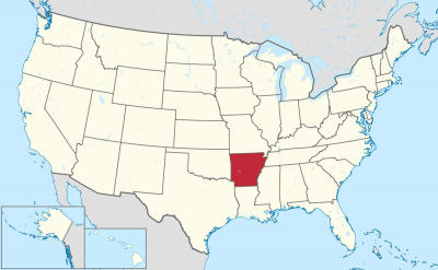


阿肯色州(英语:State of Arkansas /ˈɑːrkənsɔː/),是美国南部的一个州份,位处密西西比河中下游,北接密苏里州,西界俄克拉荷马州,南邻路易斯安那州,西南与得克萨斯州接壤,东隔密西西比河与田纳西州和密西西比州相望。其面积137,539平方公里,在五十个州内列第29位。2017年人口超过3百万,人口排名33。其首府是小石城。
アーカンソー州(英: State of Arkansas [ˈɑrkənsɔː] (![]() 音声ファイル))は、アメリカ合衆国南部[1]の州である。アメリカ合衆国50州の中で、陸地面積では第29位、人口では第32位である。州の北はミズーリ州に接し、東はテネシー州とミシシッピ州に、西はオクラホマ州とテキサス州に、南はルイジアナ州に接している。略称Ark.,AR。州都かつ人口最大の都市は、州中央部に位置するリトルロック市である。前身のアーカンソー準州から1836年6月15日に合衆国25番目の州に昇格した[2]。
音声ファイル))は、アメリカ合衆国南部[1]の州である。アメリカ合衆国50州の中で、陸地面積では第29位、人口では第32位である。州の北はミズーリ州に接し、東はテネシー州とミシシッピ州に、西はオクラホマ州とテキサス州に、南はルイジアナ州に接している。略称Ark.,AR。州都かつ人口最大の都市は、州中央部に位置するリトルロック市である。前身のアーカンソー準州から1836年6月15日に合衆国25番目の州に昇格した[2]。
地形的にはアメリカ内陸高原を構成するオザーク高原やワシタ山地(Ouachita Mountains)のある山岳地から、東部のミシシッピ川やアーカンソー・デルタのある低地まで多様である。
Arkansas (/ˈɑːrkənsɔː/)[c] is a state in the south central region of the United States, home to more than three million people as of 2018.[7][8] Its name is from the Osage language, of Siouan derivation; it denoted their related kin, the Quapaw people.[9] The state's diverse geography ranges from the mountainous regions of the Ozark and the Ouachita Mountains, which make up the U.S. Interior Highlands, to the densely forested land in the south known as the Arkansas Timberlands, to the eastern lowlands along the Mississippi River and the Arkansas Delta.
Arkansas is the 29th largest by area and the 33rd most populous of the 50 United States. The capital and most populous city is Little Rock, located in the central portion of the state, a hub for transportation, business, culture, and government. The northwestern corner of the state, such as the Fayetteville–Springdale–Rogers Metropolitan Area and Fort Smith metropolitan area, is a population, education, and economic center. The largest city in the state's eastern part is Jonesboro. The largest city in the state's southeastern part is Pine Bluff.
The Territory of Arkansas was admitted to the Union as the 25th state on June 15, 1836.[10] Much of the Delta had been developed for cotton plantations, and the state landowners there largely depended on enslaved African Americans as workers. In 1861, Arkansas seceded from the United States and joined the Confederate States of America during the Civil War.
On returning to the Union in 1868, the state continued to suffer due to its reliance on the large-scale plantation economy. Cotton continued as the leading commodity crop, although the cotton market declined. Because farmers and businessmen did not diversify and there was little industrial investment, the state fell behind in terms of its economy and opportunities for residents.
White rural interests dominated the state's politics by disenfranchisement of African Americans and by refusal to reapportion the legislature. It was not until after the civil rights movement and federal intervention that more African Americans were able to vote. The Supreme Court overturned rural domination in the South and other states that had refused to reapportion their state legislatures, or retained rules based on geographic districts. In the landmark ruling of one man, one vote, it ruled that states had to organize both houses of their legislatures by districts that held approximately equal populations, and that these had to be redefined as necessary after each decade's census.
Following World War II, Arkansas began to diversify its economy. In the 21st century, its economy is based on service industries, aircraft, poultry, steel, and tourism; along with important commodity crops of cotton, soybeans and rice.
The culture of Arkansas is observable in museums, theaters, novels, television shows, restaurants, and athletic venues across the state. Notable people from the state include politician and educational advocate William Fulbright; former president Bill Clinton, who also served as the 40th and 42nd governor of Arkansas; general Wesley Clark, former NATO Supreme Allied Commander; Walmart founder and magnate Sam Walton;[11] singer-songwriters Johnny Cash, Charlie Rich, Jimmy Driftwood, and Glen Campbell; actor-filmmaker Billy Bob Thornton; poet C. D. Wright; and physicist William L. McMillan, who was a pioneer in superconductor research.
L'Arkansas (prononcé : /aʁ.kɑ̃(n).sa(s)/3), les Arkansas (/aʁ.kɑ̃.sa/3), ou simplement les Arcs (/ɑɹk/4), (prononcé en anglais : /ˈɑɹkənsɔ/5), est un État du Sud des États-Unis. Sa capitale et plus grande ville est Little Rock, située au centre du territoire. Avec une population de 2 915 918 habitants en 2010, estimée à 3 017 804 habitants en 2019, sur une superficie de 137 732 km2, l'État est le 32e plus peuplé et le 29e plus vaste du pays. L'Arkansas est entouré par six États : l'Oklahoma à l'ouest, le Missouri au nord, le Tennessee et le Mississippi à l'est, le Texas au sud-ouest et la Louisiane au sud. Il est divisé en 75 comtés. Surnommé The Natural State (« l'État naturel »), il présente des paysages variés : des chaînes montagneuses telles que les Monts Ozarks ou les Montagnes Ouachita ; au sud, des forêts denses nommées Timberlands de l'Arkansas (en) ; à l'est, les plaines du Mississippi et du delta de l'Arkansas (en).
Le nom de l'État provient du nom de la langue Sioux et désigne les Indiens Quapaw. Il forme un territoire dès 1819 et est admis dans l'Union le 15 juin 1836, dont il devient le 25e État. Esclavagiste, il repose sur l'économie de plantation (coton, riz) et se joint aux États confédérés durant la Guerre de Sécession (1861-1865). Après avoir réintégré l'Union, l'Arkansas connaît une crise due à l'effondrement des structures économiques et sociales antérieures. Les intérêts des Blancs ruraux dominent la vie politique locale jusqu'au Mouvement des droits civiques, au milieu du XXe siècle. L'État demeure ségrégationniste jusqu'à la fin des années 1960. Il est aujourd'hui un territoire populaire, conservateur, dont l'ancrage républicain se confirme depuis les années 2000. Néanmoins, l'État demeure de tradition démocrate au niveau local et beaucoup d'électeurs se considèrent toujours Dixiecrats. La tradition conservatrice de cet État s'illustre par l'application de la peine de mort par injection létale et l'interdiction du mariage homosexuel à la suite d'un référendum.
L'Arkansas demeure un État à dominante agricole. En plus des plantations traditionnelles, il produit du soja, et tend à se spécialiser dans l'arboriculture et l'élevage de poulets. Les ressources en hydrocarbures ont également permis une industrialisation durant l'après-guerre, avec la création de papeteries, de scieries, d'usines métallurgiques (aluminium) et textiles. Durant les dernières décennies, l'Arkansas voit son économie se diversifier dans les services, accueillant des sièges sociaux de grandes entreprises (Walmart, Tyson Foods), ainsi que des aciéries et des constructeurs aéronautiques. En outre, des personnalités comme le sénateur J. William Fulbright, le chanteur de country Johnny Cash ou l'ancien président Bill Clinton en sont originaires.
L'Arkansas (pronuncia italianizzata, AFI: /arˈkansas/[2]; in inglese , /ˈɑrkənsɔː/) è uno Stato degli Stati Uniti, la cui capitale è Little Rock. Confina a nord con il Missouri, a est con il Tennessee e il Mississippi, a sud con la Louisiana e il Texas, e ad ovest con l'Oklahoma.
Il nome dello Stato deriva dalla parola Akansa (termine utilizzato dai nativi Algonchini per indicare i nativi Quapaw), modificata nella pronuncia attuale dai francesi del XVII secolo.[3]
Arkansas es uno de los cincuenta estados que, junto con Washington D. C., forman los Estados Unidos de América. Su capital y ciudad más poblada es Little Rock.
Está ubicado en la región Sur del país, división Centro Suroeste. Limita al norte con Misuri al este con el río Mississippi que lo separa de Tennessee y Mississippi, al sur con Louisiana, al suroeste con Texas y al oeste con Oklahoma. Fue admitido en la Unión el 15 de junio de 1836, como el estado número 25.
Aparte de la frontera este que forma el río Misisipi, por su territorio discurre en dirección este el río Arkansas. El nombre del estado deriva de la palabra kansas (el término con que los indios algonquinos designaban a los indios quapaw), tal como la pronunciaban los franceses en el siglo XVII.3 La geografía diversa del estado parte de las regiones montañosas del Ozark y las montañas de Ouachita, que componen las tierras altas del interior de los EE. UU., a la tierra densamente boscosa en el sur conocida como el Arkansas Timberlands, hasta las tierras bajas del este a lo largo del río Misssissippi y el delta de Arkansas. Conocido como «el estado natural», las diversas regiones de Arkansas ofrecen a los residentes y turistas una variedad de oportunidades de recreación al aire libre.
Арканза́с[1][2] (также Арка́нзас[3]; англ. Arkansas, [ˈɑːrkənsɔː] ![]() слушать[4]) — штат[5] на юге США, относится к группе штатов Юго-Западного Центра. Население 2 937 979 человек (32-е место среди штатов США; данные 2011 г.). Столица и крупнейший город — Литл-Рок[6].
слушать[4]) — штат[5] на юге США, относится к группе штатов Юго-Западного Центра. Население 2 937 979 человек (32-е место среди штатов США; данные 2011 г.). Столица и крупнейший город — Литл-Рок[6].
Официальное прозвище — «Естественный штат» (англ. Natural State).
Слово «арканзас» является алгонкинским экзонимом сиуского племени куапо.
 International cities

 Tennessee-TN

孟菲斯(英语:Memphis)是美国田纳西州谢尔比县的一座城市,也是谢尔比县县治。根据2006年的人口预估,孟菲斯的总人口为68万0768人,是田纳西州最大的城市,在美国东南部排名第二、次于佛罗里达州杰克逊维尔,也是全国第17大城市[2]。孟菲斯都会区是田纳西州次于纳什维尔都会区的第二大都会区,包含在邻近密西西比州和阿肯色州的部分地区,总人口为126万0581人。在包含诺克斯维尔、查特怒加、和纳什维尔的田纳西州四大城市里,孟菲斯是人口最多但也是最年轻的。孟菲斯位于密西西比河岸边、下契卡索陡岸(Chickasaw Bluff)上,狼河(Wolf River)的河口。其联外机场孟菲斯国际机场是世界第二大货运机场。
Memphis ist die zweitgrößte Stadt im US-Bundesstaat Tennessee und County-Sitz des Shelby County. Die Stadt liegt im äußersten Südwesten Tennessees am Ostufer des Mississippi River und hat etwa 653.000 Einwohner (Stand: 2016).
Die Stadt ist eine der Metropolen der klassischen Südstaaten. Nachdem Memphis bis in den Sezessionskrieg und die 1870er hinein floriert hatte, suchten mehrere Katastrophen die Stadt heim. In jüngster Zeit verdankt sie ihren wirtschaftlichen Aufschwung vor allem der Transportfirma FedEx, die mit Abstand größter Arbeitgeber der Stadt ist.
Die Stadt ist ein wichtiger Ort sowohl für die Entwicklung des Blues und des Souls als auch für die des Rock ’n’ Rolls. Elvis Presley lebte in Memphis, viele Größen der Rockmusik begannen ihre Karriere dort. Die Beale Street ist eines der Zentren des Blues.
 Alabama-AL
Cuba
Alabama-AL
Cuba
 Florida-FL
 Louisiana-LA
Mexico
Mississippi River
Louisiana-LA
Mexico
Mississippi River
 Mississippi-MS
 Texas-TX
United States
Texas-TX
United States

墨西哥湾是北美洲南部大西洋的一海湾,以佛罗里达半岛-古巴-犹加敦半岛一线与外海分割。北为美国,南、西为墨西哥,东南为古巴,东经佛罗里达海峡与大西洋相连,经尤卡坦海峡与加勒比海相接,是著名的墨西哥湾暖流的起点。墨西哥湾形成于3亿年前的地球板块运动。[1]
Der Golf von Mexiko (englisch Gulf of Mexico, spanisch Golfo de México; veraltet: Meerbusen von Mexiko[1]) ist eine nahezu vollständig von Nordamerika eingeschlossene Meeresbucht. Der Golf ist ein Randmeer des Atlantischen Ozeans und der nordwestliche Teil des Amerikanischen Mittelmeers.
湾の東部、北部、および北西部の海岸線はアメリカ合衆国(フロリダ州、アラバマ州、ミシシッピ州、ルイジアナ州、テキサス州)に接し、南西部と南部の海岸線はメキシコ(タマウリパス州、ベラクルス州、タバスコ州、カンペーチェ州、ユカタン州およびキンタナ・ロー州)に接している。また南東部はキューバとの海岸線をもつ。
アメリカとキューバの間にあるフロリダ海峡を経て大西洋に通じており、メキシコとキューバの間にあるユカタン海峡を経てカリブ海へと通じている。支湾として北東部にアパラチー湾、南西部にカンペチェ湾などがある。
メキシコ湾は東西の幅が約1,500km、総面積は約160万 km²で、南の3分の1は熱帯に入る。最大水深はSigsbee Deepでの4,384m。二大海流として黒潮と共に知られるメキシコ湾流はここを起源とし、巨大ハリケーンが頻繁に訪れることでも有名である。
The Gulf of Mexico (Spanish: Golfo de México) is an ocean basin and a marginal sea of the Atlantic Ocean,[1] largely surrounded by the North American continent.[2] It is bounded on the northeast, north and northwest by the Gulf Coast of the United States, on the southwest and south by the Mexican states of Tamaulipas, Veracruz, Tabasco, Campeche, Yucatan, and Quintana Roo, and on the southeast by Cuba. The US states of Texas, Louisiana, Mississippi, Alabama, and Florida border the Gulf on the north, which are often referred to as the "Third Coast", in comparison with the U.S. Atlantic and Pacific coasts.
The Gulf of Mexico formed approximately 300 million years ago as a result of plate tectonics.[3] The Gulf of Mexico basin is roughly oval and is approximately 810 nautical miles (1,500 km; 930 mi) wide and floored by sedimentary rocks and recent sediments. It is connected to part of the Atlantic Ocean through the Florida Straits between the U.S. and Cuba, and with the Caribbean Sea via the Yucatán Channel between Mexico and Cuba. With the narrow connection to the Atlantic, the Gulf experiences very small tidal ranges. The size of the Gulf basin is approximately 1.6 million km2 (615,000 sq mi). Almost half of the basin is shallow continental shelf waters. The basin contains a volume of roughly 2,500 quadrillion liters (550 quadrillion Imperial gallons, 660 quadrillion US gallons, 2.5 million km3 or 600,000 cu mi).[4] The Gulf of Mexico is one of the most important offshore petroleum production regions in the world, comprising one-sixth of the United States' total production.[5]
Le golfe du Mexique est un golfe de l'océan Atlantique, situé au sud-sud-est de l'Amérique du Nord. Il s'étend sur une superficie de 1 550 000 km2. Il baigne la péninsule de Floride, la Louisiane , le Sud-Est du Texas, la côte orientale du Mexique et une partie du littoral nord de Cuba.
Il golfo del Messico è uno dei golfi più grandi del mondo[1], situato nell'Oceano Atlantico, tra la costa dell'America settentrionale e centrale ad ovest e il mar dei Caraibi ad est.
Situato a Sud degli Stati Uniti e a Nord del Messico, e delimitato da due grandi penisole, lo Yucatán e la Florida, rispettivamente in Messico e negli Stati Uniti, comprende i litorali di undici stati: Florida, Alabama, Mississippi, Louisiana e Texas (per gli Stati Uniti) e Tamaulipas, Veracruz, Tabasco, Campeche, Yucatán e Quintana Roo (per gli Stati del Messico). Sul golfo si affaccia anche lo Stato di Cuba ed è collegato ad est al Mar dei Caraibi.
L'ampia sezione del golfo compresa tra la penisola dello Yucatán e la costa messicana assume la denominazione di baia di Campeche, mentre insieme al Mar dei Caraibi, forma il Mediterraneo Americano, espressione non riportata normalmente nelle carte, ma usata in oceanografia, geologia e biologia marina[2]. In esso viene generata la famosa Corrente del Golfo che rende abitabili la maggior parte delle coste atlantiche dell'Europa ed è inoltre luogo di formazione e transito di cicloni tropicali che qui prendono il nome di uragani a partire da tempeste tropicali che impattano poi sovente sulla costa messicana e statunitense o sulle isole caraibiche.
El golfo de México es una cuenca oceánica contenida entre los litorales de México, Estados Unidos y Cuba. Los estados mexicanos que tienen costa en este golfo son: Tamaulipas, Veracruz, Tabasco, Campeche, Yucatán; los estadounidenses son: Florida, Alabama, Misisipi, Luisiana y Texas. La península de Florida y la isla de Cuba ocupan la parte oriental del golfo, donde se encuentra la salida de este hacia el océano Atlántico, en tanto que la península de Yucatán, también al oriente, separa al golfo del mar Caribe.1
Мексика́нский зали́в (исп. Golfo de México, англ. Gulf of Mexico, фр. Golfe de Mexique) — внутреннее море западной части Атлантического океана. Ограничен с северо-запада, севера и востока побережьем США (штаты Флорида, Алабама, Миссисипи, Луизиана и Техас), на юге и юго-западе — побережьем Мексики (штаты Тамаулипас, Веракрус, Табаско, Кампече, Юкатан), а также островом Кубой[1]. Внешне напоминает овал. Площадь залива — 1543 тыс. км², объём воды — около 2332 тыс. км³[2]. Энергия вод, которые сильно нагреваются в летний период, служит основой для формирования сильных тропических штормов и мощных ураганов, крупнейшие из которых (Катрина, Густав, Иван и др.) практически ежегодно приводят к разрушительным последствиям в прибрежных регионах залива. Имеет важное хозяйственное значение для государств, омываемых им. Является одним из самых тёплых водоёмов в мире[3].
Мексиканский залив образовался примерно 300 миллионов лет назад в результате тектоники литосферных плит[4]. Поверхность залива по форме напоминает овал шириной около 1,5 тысяч километров. Дно залива составлено из осадочных пород и недавних отложений. Сообщается с Атлантическим океаном через Флоридский пролив между США и Кубой, и с Карибским морем через Юкатанский пролив между Кубой и Мексикой. Мексиканский залив и Карибское море иногда объединяют под названием Американское Средиземное море. Из-за слабой связи с Атлантическим океаном, залив испытывает лишь небольшие приливы и отливы. Площадь залива составляет 1,5—1,6 млн км², около половины составляют континентальные шельфовые воды. Объём воды в заливе оценивается в 2.5 миллиона кубических километров[3].
 Alberta-AB
 Arkansas-AR
 Colorado-CO
Canada
Colorado-CO
Canada
 Manitoba-MB
Mexico
Mississippi River
Manitoba-MB
Mexico
Mississippi River
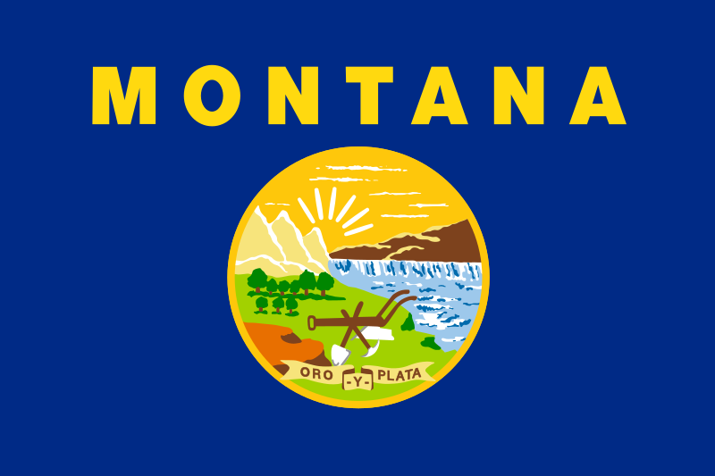 Montana-MT
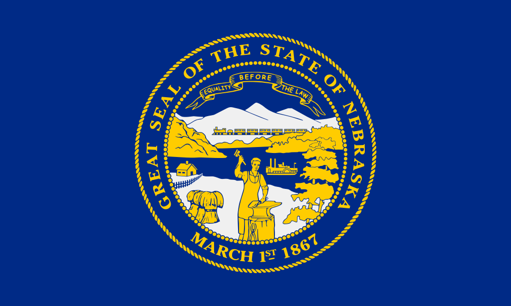 Nebraska-NE
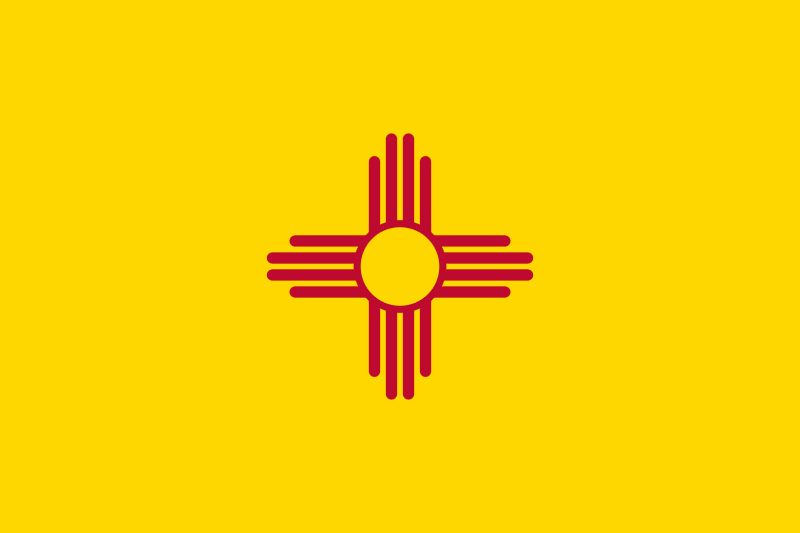 New mexico-NM
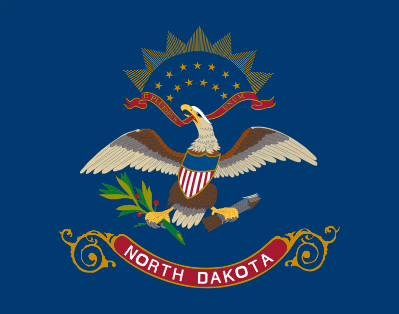 North Dakota-ND
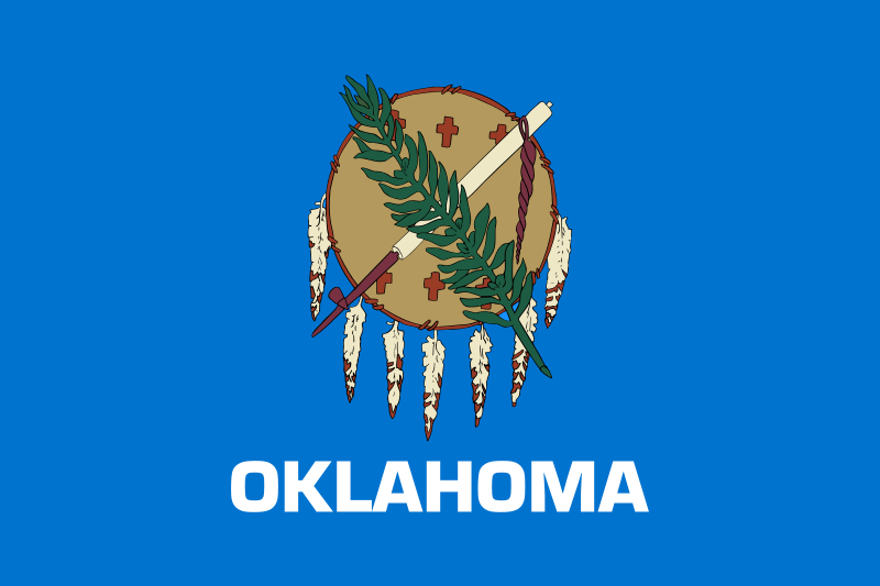 Oklahoma-OK
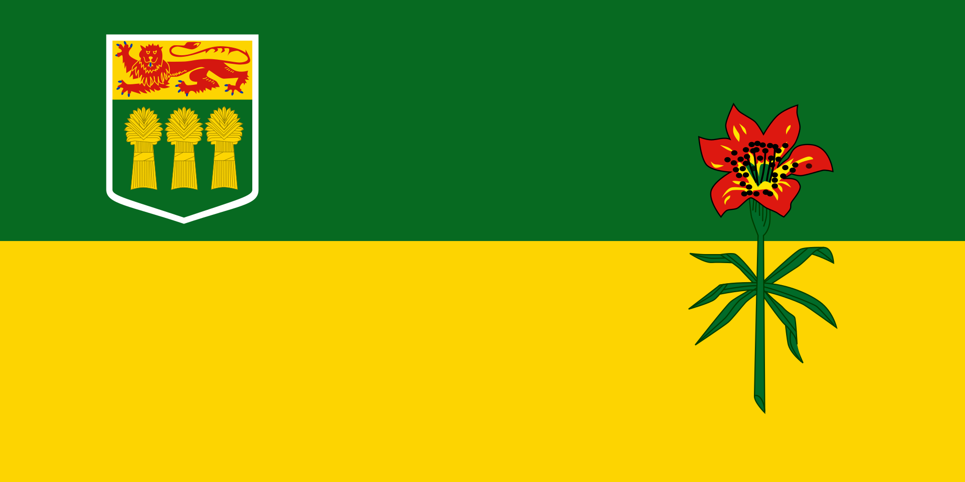 Saskatchewan-SK
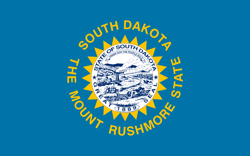 South Dakota-SD
Texas-TX
United States
South Dakota-SD
Texas-TX
United States
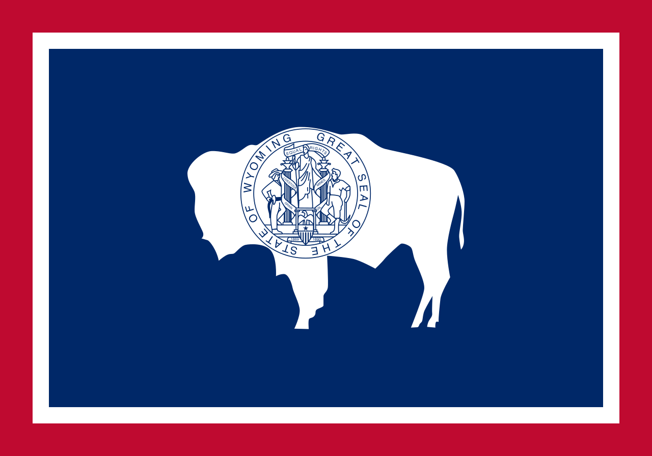 Wyoming-WY
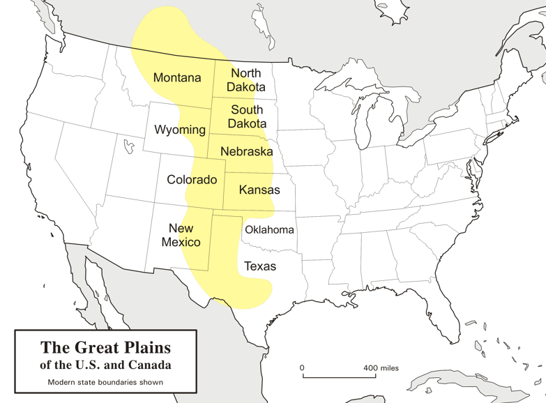
大平原(英语:Great Plains),多称北美大平原、北美大草原,是北美洲中部一块广袤的平原地区,大致位于密西西比河以西、洛基山脉以东、格兰德河以北。自然植被以草为主。
大平原东西长800千米,南北长3,200千米。另根据内布拉斯加-林肯大学大平原研究中心的定义,其总面积约130万平方千米。大平原主要包括了美国的科罗拉多州、堪萨斯州、蒙大拿州、内布拉斯加州、新墨西哥州 、北达科他州、俄克拉荷马州、南达科他州、得克萨斯州和怀俄明州,以及加拿大的草原三省(艾伯塔省、曼尼托巴省和萨斯喀彻温省)还有墨西哥的一小部分。
Die Great Plains (deutsch „Große Ebenen“) sind ein trockenes Gebiet östlich der Rocky Mountains in Nordamerika. Naturräumlich sind sie die klassischen Kurzgras-Prärien des amerikanischen Westens, heute werden sie intensiv landwirtschaftlich genutzt. Sie reichen von den kanadischen Prärieprovinzen (Alberta, Saskatchewan und Manitoba) bis nach Texas; manchmal wird auch ein kleiner Teil Mexikos dazu gezählt.
Die Great Plains umfassen (je nach Grenzziehung) eine Fläche von knapp 2 Millionen Quadratkilometern und erstrecken sich insgesamt etwa auf einer maximalen Breite von über 750 km und einer Länge von fast 3000 km. Während sie an den Rocky Mountains noch über 1800 m hoch sind, fallen sie nach Osten auf ca. 500 m ab. Damit sind sie insgesamt als Hochebene zu betrachten, die sich als „Piedmont-Plateau“, zum Teil in Schichtstufen ansteigend, vor dem Gebirge ausbreitet.
Man kann die Great Plains in zwei klimatische Regionen unterteilen, da man westlich des 100. Längengrades einen spärlichen Niederschlagsdurchschnitt vorfindet (weniger als 500 mm pro Jahr), wohingegen die östliche Region ein vergleichsweise humides Klima hat. Entsprechend dominiert im Westen die Viehwirtschaft und im Osten der Getreideanbau.
 Illinois-IL

该州位于美国中西部,毗邻密歇根湖。与其接壤的州包括:北部的威斯康星州,西部的艾奥瓦州和密苏里州,南部的肯塔基州和东部的印第安纳州。
伊利诺伊州共辖有102个县,其中本州最大城市芝加哥,隶属于库克县。该州州政府所在地斯普林菲尔德(英语:Springfield),则属桑加蒙县管辖。
该州地形平坦,属于北美中央大平原的一部分。该州除芝加哥地区外几乎全境属于密西西比河流域。州内主要河流有密西西比河,俄亥俄河和伊利诺伊河。其中密西西比河是该州西部州界,伊利诺伊州隔该河与爱奥瓦州和密苏里州相邻。俄亥俄河是伊利诺伊州东南部州界,隔河与肯塔基相望。两条河流交汇于该州最南端的开罗,该地同时也是伊利诺伊州最低点,海拔大约100米左右。伊利诺伊河是密西西比河的一级支流,由东北至西南贯穿该州,是州内主要水道,流经芝加哥、秘鲁、皮奥里亚等城市,在圣路易斯以北的奥尔顿注入密西西比河。
伊利诺伊州内地势北高南低,中部和北部地区平坦,南部地区分布有低矮丘陵。全州地形大部分为冰碛地形,形成于约一万年前的冰川纪。由于地形平坦,该州以旱作农业为第一产业的支柱产业,主要农产品有玉米、大豆、花生,畜产品以牛肉为主,农业发达且集约化程度高。
Illinois (englische Aussprache [ˌɪlɪˈnɔɪ̯]) ist ein Bundesstaat der Vereinigten Staaten. Er liegt im Mittleren Westen und grenzt im Nordosten an den Michigansee. Der Name kommt aus der Algonkin-Sprache und dem Französischen und bezeichnet den Indianerstamm der Illiniwek oder Illini, der damals das Land bewohnte und dessen Name Das Volk bedeutet. Als Ende des 17. Jahrhunderts die ersten französischen Siedler kamen, bezeichneten sie die Illini als „[les] Illinois“ (die Illini-schen, Illinois). Von 1712 an war das Gebiet unter diesem Namen französische Kolonie, die die Briten 1765 übernahmen – mit gleich geschriebenem, nun englisch ausgesprochenem Namen. So blieb es auch 1818, als Illinois Bundesstaat der Vereinigten Staaten wurde.
Die einzige Millionenstadt in Illinois ist Chicago, drittgrößte Stadt der USA hinter New York City und Los Angeles. Der offizielle Beiname Illinois’ ist Land of Lincoln nach dem 16. US-Präsidenten Abraham Lincoln, der in der Hauptstadt Springfield lebte und dort nach seiner Ermordung bestattet wurde.
Der Mississippi bildet im Westen die Grenze zu den Staaten Iowa (im Nordwesten) und Missouri (im Südwesten). Im Südosten übernimmt der Ohio River diese Rolle zu dem Staat Kentucky. Nördlich von Illinois befindet sich Wisconsin und im Osten Indiana. Durchflossen wird der Staat von den Flüssen Illinois River und Kaskaskia River, die in den Mississippi münden, sowie Embarras River, Chicago River und Sangamon River, die im Wabash bzw. Illinois River einfließen. Im Nordosten hat der Staat eine gemeinsame Grenze mit Michigan in der Mitte des Michigansees. Die höchste natürliche Erhebung in Illinois ist der Charles Mound im Jo Daviess County mit einer Höhe von 376 m. Der höchste Punkt insgesamt ist jedoch die Antennenspitze des Willis Towers in Chicago (708 m über NN., 527 m über Straßenniveau). Der tiefste Punkt (85 m) ist am Zusammenfluss von Mississippi und Ohio, im Stadtgebiet von Cairo im Alexander County.
Mit seinem flachen Terrain wird Illinois stark von der Vermessung des Congressional Survey Systems geprägt. Die Ausnahmen im quadratischen Straßenverlauf und den Feldgrenzen zum regelmäßigen Nord-Süd- und Ost-West-Muster bilden die Eisenbahnen und die zu ihnen parallel verlaufenden Fernstraßen.
イリノイ州(イリノイしゅう、英: State of Illinois、略号: IL[3], Ill.[3])は、アメリカ合衆国中西部に位置する州である[4]。合衆国に加盟したのは21番目であり、人口では国内5番目、中西部では人口最大、かつ民族構成が最も多様化した州である[5]。
州都はスプリングフィールド市[4][6]、最大都市は北東部のシカゴ市で大規模な工業地帯を持ち人口の8割が住む[6]。州の中部や西部には小さな工業都市と生産性の高い農業地帯があり、南部には石炭、木材および石油など天然資源に恵まれ、幅広い経済基盤がある。シカゴの港はイリノイ川を経由して五大湖とミシシッピ川を結ぶ交通の要衝である。イリノイ州は国内における商工業、交通、政治、財政の中枢的存在ということもあってアメリカ合衆国の縮図と言われる[6]。AP通信が行った21項目の人口動態解析に拠るとイリノイ州は「最も平均的な州」であり、州の中央にあるピオリア市は「ピオリアでうまく行くかい?」という疑問文が、アメリカ大衆の主流に訴えるものであるかどうかの隠喩になってきており、新しい商品、サービスおよび世論調査では市場調査の場所として使われることが多い[5]。
現在のイリノイ州南部にあったミシシッピ文化の都市カホキアは西暦1300年から1400年にかけて人口が4万人近くいたと言われ、当時さらには1790年までアメリカ合衆国の中で最大の都市だった(1790年にニューヨーク市の人口が4万人を超えた)。カホキアの地は次第に廃れていき、アメリカ独立のときはわずか2,000人ほどのインディアンと少数のフランス人開拓者がいただけだった[7]。1810年代にケンタッキー州から移民開拓者が到着し始め、1818年には州に昇格した。シカゴはシカゴ川の岸で、ミシガン湖南部の数少ない天然の良港の地に1830年代に設立された[8]。ジョン・ディアが籾殻を取る鉄製鋤を発明したことで州中部の肥沃なプレーリーを世界で最も生産力があり貴重な農地に変え、これと鉄道が開通したことで、ドイツやスウェーデンの移民農業者を惹きつけることになった。
1900年までに北部の工業都市や中部および南部の炭鉱で働き口が増えたことで東ヨーロッパや南ヨーロッパからの移民も惹きつけた。その工業生産力で2度の世界大戦中は重要な兵器製造工場になった。南部の田園地帯からシカゴへ、アフリカ系アメリカ人の大移住が起こり、その大きく重要な社会が形成されて、ジャズやブルースのような文化を創った。今日州内人口の74%は州の北東部隅、特にシカゴとその大都市圏に居住している。
イリノイ州から3人のアメリカ合衆国大統領が選ばれた。エイブラハム・リンカーン、ユリシーズ・グラントおよびバラク・オバマである。しかし、イリノイ州で生まれた大統領は、タンピコ生まれでディクソンで育ち、ユーレカ大学を出たロナルド・レーガンのみである。リンカーンは州都スプリングフィールドのオークリッジ墓地に埋葬されており、イリノイ州に埋葬されている唯一の大統領である。今日イリノイ州は「リンカーンの地 (Land of Lincoln)」という州の公式スローガンでリンカーンが残した遺産の重要さを強調しており、この言葉は車のナンバープレートにも表示されている[9]。
Illinois (/ˌɪləˈnɔɪ/ (![]() listen) IL-ə-NOY) is a state in the Midwestern and Great Lakes regions of the United States. It has the fifth largest gross domestic product (GDP), the sixth largest population, and the 25th largest land area of all U.S. states. Illinois has been noted as a microcosm of the entire United States.[7] With Chicago in northeastern Illinois, small industrial cities and immense agricultural productivity in the north and center of the state, and natural resources such as coal, timber, and petroleum in the south, Illinois has a diverse economic base, and is a major transportation hub. The Port of Chicago connects the state to international ports via two main routes: from the Great Lakes, via the Saint Lawrence Seaway, to the Atlantic Ocean and from the Great Lakes to the Mississippi River, via the Illinois River, through the Illinois Waterway. The Mississippi River, the Ohio River, and the Wabash River form parts of the boundaries of Illinois. For decades, Chicago's O'Hare International Airport has been ranked as one of the world's busiest airports. Illinois has long had a reputation as a bellwether both in social and cultural terms[7] and, through the 1980s, in politics.
listen) IL-ə-NOY) is a state in the Midwestern and Great Lakes regions of the United States. It has the fifth largest gross domestic product (GDP), the sixth largest population, and the 25th largest land area of all U.S. states. Illinois has been noted as a microcosm of the entire United States.[7] With Chicago in northeastern Illinois, small industrial cities and immense agricultural productivity in the north and center of the state, and natural resources such as coal, timber, and petroleum in the south, Illinois has a diverse economic base, and is a major transportation hub. The Port of Chicago connects the state to international ports via two main routes: from the Great Lakes, via the Saint Lawrence Seaway, to the Atlantic Ocean and from the Great Lakes to the Mississippi River, via the Illinois River, through the Illinois Waterway. The Mississippi River, the Ohio River, and the Wabash River form parts of the boundaries of Illinois. For decades, Chicago's O'Hare International Airport has been ranked as one of the world's busiest airports. Illinois has long had a reputation as a bellwether both in social and cultural terms[7] and, through the 1980s, in politics.
The capital of Illinois is Springfield, which is located in the central part of the state. Although today Illinois's largest population center is in its northeast, the state's European population grew first in the west as the French settled lands near the Mississippi River, when the region was known as Illinois Country and was part of New France. Following the American Revolutionary War, American settlers began arriving from Kentucky in the 1780s via the Ohio River, and the population grew from south to north. In 1818, Illinois achieved statehood. Following increased commercial activity in the Great Lakes after the construction of the Erie Canal, Chicago was incorporated in the 1830s on the banks of the Chicago River at one of the few natural harbors on the southern section of Lake Michigan.[8] John Deere's invention of the self-scouring steel plow turned Illinois's rich prairie into some of the world's most productive and valuable farmland, attracting immigrant farmers from Germany and Sweden. The Illinois and Michigan Canal (1848) made transportation between the Great Lakes and the Mississippi River valley faster and cheaper, and new railroads carried immigrants to new homes in the country's west and shipped commodity crops to the nation's east. The state became a transportation hub for the nation.[9]
By 1900, the growth of industrial jobs in the northern cities and coal mining in the central and southern areas attracted immigrants from Eastern and Southern Europe. Illinois was an important manufacturing center during both world wars. The Great Migration from the South established a large community of African Americans in the state, including Chicago, who founded the city's famous jazz and blues cultures.[10][11] Chicago, the center of the Chicago Metropolitan Area, is now recognized as a global city. Chicagoland, Chicago's metropolitan area, encompasses about 65% of the state's population. The most populous metropolitan areas outside the Chicago area include, Metro East (of Greater St. Louis), Peoria and Rockford.
Three U.S. presidents have been elected while living in Illinois: Abraham Lincoln, Ulysses S. Grant, and Barack Obama. Additionally, Ronald Reagan, whose political career was based in California, was born and raised in the state. Today, Illinois honors Lincoln with its official state slogan Land of Lincoln, which has been displayed on its license plates since 1954.[12][13] The state is the site of the Abraham Lincoln Presidential Library and Museum in Springfield and the future home of the Barack Obama Presidential Center in Chicago.
L'Illinois (/i.li.nwa/2 Écouter ; en anglais : /ˌɪləˈnɔɪ/3 Écouter ) est un État du Midwest des États-Unis. Sa capitale est Springfield, mais la plus grande ville est Chicago, troisième agglomération des États-Unis, qui concentre à elle seule plus du cinquième de la population totale de l'État (65 % avec l'agglomération). Il comporte 102 comtés. Avec 12 830 632 habitants en 2010 sur une superficie de 149 998 km2, il est le 6e du pays par sa population et le 25e par sa taille. Bordé au nord-est par le lac Michigan, ses États voisins sont le Wisconsin au nord, l'Iowa et le Missouri à l'ouest, le Kentucky au sud et l'Indiana à l'est4. Au cœur de la région des Grands Lacs, l'Illinois est un hub de transports : le port de Chicago est relié à l'Océan Atlantique par la voie maritime du Saint-Laurent, et au Mississippi par la rivière Illinois. L'aéroport international O'Hare de Chicago est en outre l'un des plus fréquentés au monde.
Son nom vient de la tribu amérindienne des Illinois qui y vivait. Bien que la majeure partie de la population actuelle se concentre dans l'aire métropolitaine de Chicago, au nord de l'État, les premiers immigrants (français et britanniques) se sont d'abord installés à l'ouest. Après la guerre d'indépendance, des habitants venus du Kentucky commencent à peupler l'Illinois, qui devient un État en 1818. Chicago est fondée vers 1830 sur les bords de la rivière Chicago, dans une baie au sud du Lac Michigan. À partir de 1900, le développement de l'industrie et de l'agriculture productiviste attire des immigrants européens, notamment allemands et suédois. La Grande migration afro-américaine, de 1910 à 1930, voit s'établir de nombreuses communautés noires venues du Sud et provoque la création d'une scène artistique de jazz et de blues.
Aujourd'hui, l'Illinois a une économie diversifiée et accueille le siège social de plusieurs grandes entreprises américaines, dont John Deere, Boeing, United Airlines ou McDonald's. Il comporte de nombreuses équipes sportives, essentiellement basées à Chicago, dont les plus importantes sont les Bulls (basket-ball), les Blackhawks (hockey sur glace), les Cubs et les White Sox (baseball), et les Bears (football américain). Bastion du Parti démocrate depuis les années 1990, l'Illinois était le lieu de résidence de trois présidents américains : Abraham Lincoln, Ulysses S. Grant et Barack Obama, qui en était le sénateur avant son élection à la présidence.
L'Illinois (AFI: /illiˈnɔis/[2][3]; in inglese , [ɪɫɪˈnɔɪ])[4] è uno Stato federale del Midwest degli Stati Uniti d'America. Confina a nord con il Wisconsin, a sud con il Kentucky, ad ovest con l'Iowa e il Missouri e ad est con l'Indiana. Per un breve tratto a nord-est l'Illinois confina col lago Michigan. La capitale è Springfield. Con 12.880.580 abitanti, è lo stato più popoloso del Midwest, e il quinto più popoloso degli Stati Uniti. Circa il 65% della popolazione dello stato vive nell'area metropolitana di Chicago, uno dei più grandi centri industriali e finanziari del mondo, il secondo più grande centro industriale del paese, dopo Los Angeles, e il secondo più grande centro finanziario della nazione, dopo New York.
Sebbene l'Illinois abbia un'economia molto diversificata, essendo uno dei principali centri finanziari degli Stati Uniti ed essendo altamente industrializzato, dalla crisi economica del 2008-2010 lo Stato è entrato in crisi, con debiti di più 5.000 milioni di euro e con ritardi nei pagamenti per i servizi basici, come istruzione e sanità.[5]
Geograficamente, l'Illinois è caratterizzato da un terreno accidentato e da un clima instabile. L'agricoltura è una fonte importante di reddito per lo Stato. Il turismo e la fornitura di mezzi di trasporto e telecomunicazioni sono altre importanti fonti di reddito. Chicago è la più grande città dello stato, e uno dei centri ferroviari e aeroportuali più dinamici degli Stati Uniti.
L'Illinois è noto per la sua vasta e diversificata popolazione e il suo equilibrio tra le aree rurali, le piccole città industriali, i vasti sobborghi e la grande area metropolitana di Chicago. La sua economia diversificata e la sua posizione centrale, l'hanno reso un importante centro di trasporto per 150 anni. Questa miscela di fabbriche e aziende agricole, zone urbane e rurali, hanno reso l'Illinois un microcosmo all'interno della nazione.
Il soprannome dell'Illinois è "The Prairie State Illinois", che significa "Lo Stato della prateria". Un altro soprannome è The Land of Lincoln (terra di Lincoln); molti residenti sono orgogliosi del fatto che il presidente statunitense Abraham Lincoln abbia trascorso gran parte della sua vita nello stato. La sua tomba si trova nella capitale Springfield.
L'animale scelto come simbolo dello stato è il cervo dalla coda bianca.
I primi europei a esplorare la regione furono missionari francesi e fece parte della Nuova Francia fino al 1763, quando divenne di dominio britannico. Nel 1783, dopo la fine della guerra di indipendenza americana nel 1776, entrò a far parte della allora chiamata Territorio del nord-ovest. Il 3 febbraio 1809, fu creato il territorio dell'Illinois e il 3 dicembre 1818, l'Illinois divenne il 21º stato degli Stati Uniti d'America.
Illinois (antiguamente en español Ilinés1) es uno de los cincuenta estados que, junto con Washington D. C., forman los Estados Unidos de América. Su capital es Springfield y su ciudad más poblada, Chicago. Está ubicado en la región Medio Oeste del país, división Centro Noreste, limitando al norte con Wisconsin, al noreste con el lago Míchigan, al este con Indiana —parte de este límite lo forma el río Wabash—, al sureste y sur con el río Ohio que lo separa de Kentucky, y al oeste con el río Misisipi que lo separa de Misuri (al suroeste) y Iowa (al noroeste). Con 12 671 821 habs. En 2019 es el sexto estado más poblado, por detrás de California, Texas, Florida, Nueva York y Pensilvania. Fue admitido en la Unión el 3 de diciembre de 1818, como el estado número 21.
Cerca de un 65 % de la población del estado vive en el área metropolitana de Chicago, uno de los mayores centros industriales y financieros del mundo, el segundo mayor centro industrial del país —después de Los Ángeles— y el segundo mayor centro financiero de Estados Unidos —después de Nueva York.
A pesar de que Illinois tiene una economía altamente diversificada, siendo uno de los principales centros financieros de Estados Unidos, y un estado muy industrializado, a partir de la crisis económica de 2008-2010 el Estado se encuentra en quiebra técnica con una deuda de más de 5000 millones de dólares y sin atender los pagos de los servicios básicos.2
Geográficamente, Illinois se caracteriza por su terreno poco accidentado en general, y por su clima inestable. La agricultura es una importante fuente de ingresos de Illinois. El turismo y la prestación de servicios de transportes y telecomunicaciones son otras fuentes de ingresos importantes en el estado. Chicago es la ciudad más grande del estado y uno de los centros ferroviarios y aeroportuarios más dinámicos de Estados Unidos.
Illinois es conocido por su población grande y diversa y su equilibrio entre áreas rurales, pequeñas ciudades industriales, extensos suburbios y una gran área metropolitana, la de Chicago. Su economía diversa y su posición central ha hecho de él un importante centro de transportes durante 150 años. Es esta mezcla de fábricas y granjas, de áreas urbanas y rurales, la que hace de Illinois un microcosmos dentro de la nación.
El apodo de Illinois es The Prairie State, que significa "El Estado de la Pradera". Otro apodo es el de The Land of Lincoln (La Tierra de Lincoln); muchos de sus habitantes se enorgullecen del hecho de que el presidente estadounidense Abraham Lincoln pasó la mayor parte de su vida en el estado. Su tumba se encuentra en Springfield.
Los primeros europeos en explorar la región del actual Illinois fueron misioneros franceses. Esta región formó parte de Nueva Francia hasta 1763, año en que pasó a dominio británico. En 1783, después del fin de la Guerra de la Independencia Estadounidense de 1776, pasó a formar parte del entonces llamado Territorio del Noroeste. El 3 de febrero de 1809, se creó el Territorio de Illinois. El 3 de diciembre de 1818, Illinois pasó a ser el 21er estado de los Estados Unidos.
Иллино́йс[1][2] (англ. Illinois, американское произношение: [ˌɪləˈnɔɪ] (![]() слушать)[3]) — штат на Среднем Западе США. Находится на 25-м месте по занимаемой площади — 149 998 км², и на пятом месте по численности населения[4], которая по оценкам Бюро переписи населения США на 2011 год составляет 12 869 257 человек[5]. Столица штата — Спрингфилд, крупнейший город — Чикаго, другие крупные города: Орора, Рокфорд, Джолиет.
слушать)[3]) — штат на Среднем Западе США. Находится на 25-м месте по занимаемой площади — 149 998 км², и на пятом месте по численности населения[4], которая по оценкам Бюро переписи населения США на 2011 год составляет 12 869 257 человек[5]. Столица штата — Спрингфилд, крупнейший город — Чикаго, другие крупные города: Орора, Рокфорд, Джолиет.
Штат располагает широкой экономической базой: на северо-востоке в Чикаго и небольших городах сосредоточены промышленные предприятия, в центральной части предприятия сельского хозяйства, а юг богат природными ресурсами, среди которых уголь, лес, нефть и др. Иллинойс — основной транспортный узел США. Через морской путь Святого Лаврентия порт Чикаго связан с другими крупными портами Великих озёр и Атлантическим океаном, а через реку Иллинойс располагает выходом к реке Миссисипи. Международный аэропорт О’Хара в Чикаго на протяжении десятилетий из года в год признавался самым загруженным аэропортом мира. Штат Иллинойс также имеет высокую репутацию в социальной сфере, культуре и политике[6].
Официальное прозвище штата — «Земля Линкольна» (англ. Land of Lincoln), а также «Штат в прерии» (англ. Prairie State). Официальный девиз — «Суверенитет штата, единство нации» (англ. State sovereignty, national union).
 Iowa-IA


アイオワ州(英: State of Iowa [ˈaɪəwə, ˈaɪ.oʊə] (![]() 音声ファイル))は、アメリカ合衆国中西部に位置し、「アメリカのハートランド(中心地)」と呼ばれる州である。1846年12月28日にアメリカ合衆国29番目の州となった。アメリカ合衆国50州の中で、陸地面積では第26位、人口では第30位である。州都かつ人口最大の都市はデモインである。「アイオワ」という名前はヨーロッパ人がこの地域に探検に入った時代に、数多く住んでいたインディアン部族の中のアイオワ族から採られた[1]。その意味は、インディアン部族のスー族の言葉で「眠たがり」という意味である。アイオワ州法によって、アメリカ合衆国大統領選挙の前哨戦である大統領候補指名党員選挙を、全国に先駆けて行うことが定められている。したがって、アイオワ州党員選挙は大統領選挙の初戦としての位置付けにあり、大統領選挙の際には世界的に注目される。なお、アイオワ州党員選挙にて敗北した候補者が大統領に就任した例は少なく、「アイオワを制する者が大統領選挙を制する」とも言われている。
音声ファイル))は、アメリカ合衆国中西部に位置し、「アメリカのハートランド(中心地)」と呼ばれる州である。1846年12月28日にアメリカ合衆国29番目の州となった。アメリカ合衆国50州の中で、陸地面積では第26位、人口では第30位である。州都かつ人口最大の都市はデモインである。「アイオワ」という名前はヨーロッパ人がこの地域に探検に入った時代に、数多く住んでいたインディアン部族の中のアイオワ族から採られた[1]。その意味は、インディアン部族のスー族の言葉で「眠たがり」という意味である。アイオワ州法によって、アメリカ合衆国大統領選挙の前哨戦である大統領候補指名党員選挙を、全国に先駆けて行うことが定められている。したがって、アイオワ州党員選挙は大統領選挙の初戦としての位置付けにあり、大統領選挙の際には世界的に注目される。なお、アイオワ州党員選挙にて敗北した候補者が大統領に就任した例は少なく、「アイオワを制する者が大統領選挙を制する」とも言われている。
アイオワ州となった地域はフランスのヌーベルフランスと呼ばれた植民地に属していた。アメリカ合衆国によるルイジアナ買収後、開拓者が農業に基づく経済の基礎を作り、「コーンベルト」と呼ばれる地域の中心になった[2]。「世界の食糧の首都」と呼ばれることも多い[3]。20世紀の後半に農業経済から、先進的製造、加工、金融、バイオテクノロジー、再生可能エネルギーなど多様な経済分野に移行してきた[3][4]。生活するには安全な州として位置づけられてきている[5]。
Iowa (/ˈaɪəwə/ (![]() listen))[5][6][7] is a state in the Midwestern United States, bordered by the Mississippi River to the east and the Missouri River and Big Sioux River to the west. It is bordered by six states: Wisconsin to the northeast, Illinois to the east and southeast, Missouri to the south, Nebraska to the west, South Dakota to the northwest, and Minnesota to the north.
listen))[5][6][7] is a state in the Midwestern United States, bordered by the Mississippi River to the east and the Missouri River and Big Sioux River to the west. It is bordered by six states: Wisconsin to the northeast, Illinois to the east and southeast, Missouri to the south, Nebraska to the west, South Dakota to the northwest, and Minnesota to the north.
In colonial times, Iowa was a part of French Louisiana and Spanish Louisiana; its state flag is patterned after the flag of France. After the Louisiana Purchase, people laid the foundation for an agriculture-based economy in the heart of the Corn Belt.[8]
In the latter half of the 20th century, Iowa's agricultural economy made the transition to a diversified economy of advanced manufacturing, processing, financial services, information technology, biotechnology, and green energy production.[9][10] Iowa is the 26th most extensive in land area and the 30th most populous of the 50 U.S. states. The state's capital, most populous city, and largest metropolitan area fully located within the state is Des Moines. A portion of the larger Omaha, Nebraska, metropolitan area extends into three counties of southwest Iowa.[11] Iowa has been listed as one of the safest U.S. states to live in.[12]
L'Iowa (prononcé en français : /i.jo.wa/, en anglais : /ˈaɪ.ə.wə/) est un État du Midwest des États-Unis, parfois appelé The American Heartland (« le cœur américain »). Il est bordé au nord par le Minnesota, par le Wisconsin et l'Illinois à l'est, par le Missouri au sud et par le Nebraska et le Dakota du Sud à l'ouest2. Ses frontières à l'est et l'ouest sont formées par des rivières, respectivement le Mississippi, d'une part, et le Missouri et la Big Sioux, de l'autre. Son surnom officiel est The Hawkeye State depuis 1838, soit 8 ans avant qu'il ne devienne officiellement un État au sein de l'Union. En 2019, sa population s'élève à 3 155 070 habitants3.
À l'époque coloniale, l'Iowa fait partie de la Louisiane française et de la Louisiane espagnole. Son drapeau est inspiré directement de celui de la France. Après la vente de la Louisiane par Napoléon, les colons décident de fonder l'économie de l'État sur l'agriculture, de sorte que l'Iowa devient, plus tard, une partie de la Corn Belt. Dans la seconde moitié du XXe siècle, l'économie de l'Iowa, jusqu'alors monopolisée par l'agriculture, se diversifie avec l'arrivée des industries techniquement avancées, des services financiers, de la biotechnologie et de la production d'énergies renouvelables.
L'Iowa est le 20e État le plus étendu du pays et le 30e plus peuplé. Sa capitale, qui est aussi la ville la plus peuplée de l'État, est Des Moines. L'Iowa est répertorié, en 2009, comme l'un des États les plus sûrs des États-Unis. Il est également le premier État à voter lors des primaires présidentielles avec le caucus de l'Iowa.
L'Iowa (in inglese: [ˈaɪ.əwɒ]) è il 29º stato federato degli Stati Uniti d'America, essendo entrato nell'Unione il 28 dicembre 1846. Il nome ufficiale dello stato è "Stato dell'Iowa" (State of Iowa), la sua capitale è Des Moines.
Il nome dello Stato deriva da quello di una tribù di nativi americani di ceppo Sioux, gli Iowa appunto, che abitarono queste terre fino al 1836, quando volontariamente le cedettero agli Stati Uniti e si ritirarono nell'Oklahoma.
Iowa es uno de los cincuenta estados que, junto con Washington D. C., forman los Estados Unidos de América. Su capital y ciudad más poblada es Des Moines. Está ubicado en la región Medio Oeste del país, división Centro Noroeste, limitando al norte con Minesota, al este con el río Misisipi que lo separa de Wisconsin (al noreste) e Illinois (al sureste), al sur con Misuri, al oeste con el río Misuri que lo separa de Nebraska, y al noroeste con el río Big Sioux que lo separa de Dakota del Sur. Fue admitido en la Unión el 28 de diciembre de 1846, como el estado número 29.
El 92 por ciento de la población del estado son blancos, y el mayor grupo étnico de Iowa son los alemanes, que componen el 35,7% de la población del estado. Sus principales fuentes de renta son la manufactura, la agricultura y el turismo. Es el mayor productor de soja y etanol de los Estados Unidos, y posee el mayor rebaño porcino del país.
El nombre del estado proviene del pueblo nativo americano Iowa que habitaba la región. Los primeros europeos que exploraron la región fueron los franceses Louis Jolliet y Jacques Marquette en 1673, quienes describieron la región como verde y fértil. Los primeros colonos blancos se instalaron en la región en junio de 1833. El 28 de diciembre de 1846, Iowa se convirtió en el 29º estado de la Unión.
Айова[2] (англ. Iowa, /ˈaɪəwə/)[3] (варианты ударения: А́йова[4] и Айо́ва[5]) — 29-й по счёту штат[6] США, расположенный на Среднем Западе в области, называемой «Сердце Америки». Айова является частью бывшей французской колонии «Новая Франция», перешедшей к США в результате Луизианской покупки. Поселенцами был заложен фундамент сельскохозяйственной экономики штата, расположенного в центре кукурузного пояса США[7]. Штат иногда называют продовольственной столицей мира[8].
Название штата позаимствовано от наименования племени айова, одного из индейских племён, проживавших на территории штата до прихода европейских поселенцев[9].
Во второй половине XX века в Айове был осуществлён переход от сельскохозяйственной к многоотраслевой экономике, включающей передовые производственные, обрабатывающие, финансовые услуги, информационные технологии, биотехнологии и экологически чистое производство энергии[10][11]. Занимает 26-е место по территории в США и 30-е по численности населения. Столица и крупнейший город штата — Де-Мойн. Айова относится к числу самых безопасных штатов страны[12].
 Kentucky-KY


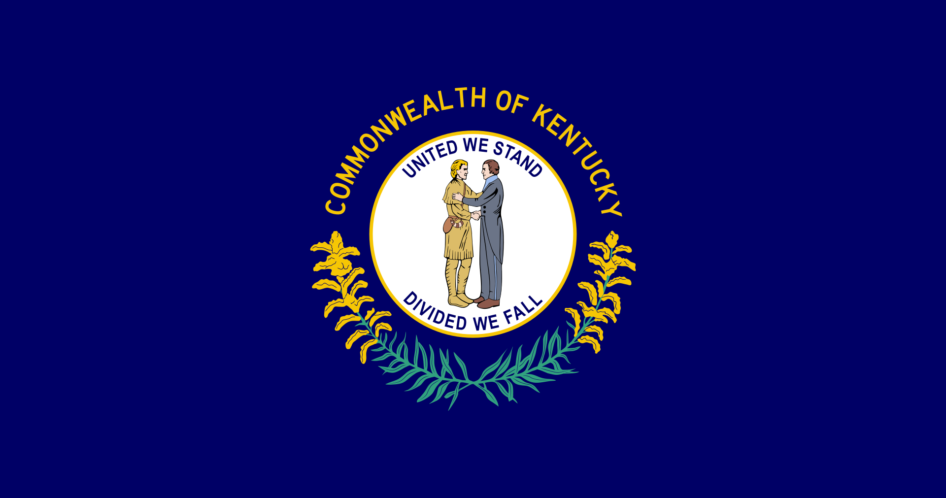
肯塔基州(英语:Commonwealth of Kentucky)是美国中东部的一个州,正式名称为肯塔基邦,面积104,749平方公里,在全国排名37。2005年人口4,041,769人,全国排名第26位。
肯塔基州在美国革命时属弗吉尼亚州一部分,称肯塔基县。1792年肯塔基脱离弗吉尼亚州,成为美国的第十五个州。肯塔基州以纯种马和威士忌闻名。另外快餐连锁企业肯德基(Kentucky Fried Chicken)也以肯塔基州为发源地。
Kentucky (engl. Aussprache [kənˈtʰʌki]) (offiziell The Commonwealth of Kentucky) ist ein Bundesstaat der Vereinigten Staaten von Amerika. Der Name des Staates ist shawnesischer oder irokesischer Herkunft, möglicherweise aus dem Wyandotischen, mit der Bedeutung „Wiese“, „Aue“, „Flur“. Im Senecaischen, ebenfalls einer irokesischen Sprache, bedeutet das Wort geda’geh „auf dem Feld“.[1] Den Beinamen Bluegrass State, womit die von März bis April blaugrün blühenden Grasweiden gemeint sind, trägt Kentucky als verbreitete Umschreibung.
Kentucky war zunächst ein Teil Virginias und trat 1792 als 15. Staat den Vereinigten Staaten bei. Im Sezessionskrieg versuchte Kentucky anfangs neutral zu bleiben, dann standen Einwohner des Staates auf beiden Seiten, wie z. B. Abraham Lincoln als Präsident der Union und Jefferson Davis als Präsident der Konföderation. Das United States Census Bureau zählt Kentucky heute jedoch eindeutig zu den Südstaaten.
Neben den Bundesstaaten Virginia, Pennsylvania und Massachusetts führt Kentucky den amtlichen Namen „Commonwealth of Kentucky“ im Gegensatz zu der sonst üblichen Gliedstaaten-Bezeichnung als „State“.
ケンタッキー州(英: Commonwealth of Kentucky)は、アメリカ合衆国中東部にある州(コモンウェルス)である。州都はフランクフォートで、最大都市はルイビルである。アメリカ合衆国50州の中で、陸地面積では第37位、人口では第26位である。元はバージニア州の一部だった。1792年にアメリカ合衆国15番目の州に昇格した。
他の主要な都市にレキシントンがある。また、オハイオ州の大都市、シンシナティの大都市圏の一部はケンタッキー州北部にまたがっており、北ケンタッキー地域と呼ばれる。
Kentucky (UK: /kɛnˈtʌki/ ken-TUK-ee, US: /kən-/ (![]() listen) kən-),[4] officially the Commonwealth of Kentucky, is a U.S. state in the Southern region of the country. It was admitted into the Union as the 15th state on June 1, 1792, splitting from Virginia in the process.[5] Kentucky is the 37th most extensive and the 26th most populous of the 50 United States.
listen) kən-),[4] officially the Commonwealth of Kentucky, is a U.S. state in the Southern region of the country. It was admitted into the Union as the 15th state on June 1, 1792, splitting from Virginia in the process.[5] Kentucky is the 37th most extensive and the 26th most populous of the 50 United States.
The bluegrass region in the central part of the state contains the state's capital, Frankfort, as well as its two largest cities, Louisville and Lexington. Together they comprise more than 20% of the state's population.[3] Kentucky shares borders with Illinois, Indiana, and Ohio to the north, West Virginia and Virginia to the east, Tennessee to the south, and Missouri to the west.
Kentucky is known as the "Bluegrass State", a nickname based on Kentucky bluegrass, a species of grass found in many of its pastures, which has supported the thoroughbred horse industry in the center of the state.[6] It is home to the world's longest cave system: Mammoth Cave National Park, as well as one of the greatest lengths of navigable waterways and streams in the contiguous United States and the two largest man-made lakes east of the Mississippi River. The state is also known for horse racing, bourbon, moonshine, coal, "My Old Kentucky Home" historic state park, automobile manufacturing, tobacco, bluegrass music, college basketball, Kentucky Fried Chicken, and the Kentucky colonel.
Le Kentucky /kɑ̃n̪.ty.ki/ ou /kɛn̪.tə.ki/ (prononcé en anglais /kənˈtʌki/) est un État (officiellement, un Commonwealth, comme seulement trois autres États parmi les cinquante) des États-Unis, à la limite du Midwest et du Sud profond. Il est bordé au nord par l'Illinois, l'Indiana et l'Ohio, à l'est par la Virginie-Occidentale et la Virginie, au sud par le Tennessee et à l'ouest par le Missouri.
Faisant initialement partie de la Virginie, le Kentucky devient en 1792 le 15e État à rejoindre l'Union. Il est le 37e État par sa superficie et le 26e État par sa population parmi les 50 États américains.
Le Kentucky est connu comme le « Bluegrass State » (État de l'herbe bleue), un surnom dû à l'« herbe bleue » que l'on trouve dans de nombreux pâturages de son sol fertile. Une des principales régions du Kentucky est la Bluegrass region, dans le centre de l'État, où se trouvent les deux principales villes, Louisville et Lexington. Le Kentucky présente divers environnements et d'abondantes ressources dont le plus long réseau de grottes du monde au parc national de Mammoth Cave, le plus long système de voies navigables des États-Unis contigus et les deux plus grand lacs artificiels à l'est du Mississippi.
Le Kentucky est aussi connu pour ses courses de chevaux, ses distilleries de bourbon et son alcool de contrebande (Kentucky Moonshine), son charbon, son tabac, sa construction automobile, la musique bluegrass, le site historique My Old Kentucky Home, le basket universitaire et la société Kentucky Fried Chicken.
Il Commonwealth del Kentucky (abbreviazione comune: Kentucky in inglese , [kɨnˈtʌki]; denominazione ufficiale in lingua inglese: Commonwealth of Kentucky; soprannome: Bluegrass State) è uno stato federato degli Stati Uniti d'America. La capitale è Frankfort. Confina ad ovest con il Missouri, a nord con l'Ohio, l'Illinois e l'Indiana, a sud con il Tennessee e ad est con Virginia e Virginia Occidentale.
Le origini del nome non sono chiare, ma si ipotizza che derivi da un termine irochese, col significato di “prateria”, “campo”, ma anche “terra del domani” o “fiume di sangue”[2].
Kentucky, oficialmente mancomunidad de Kentucky (en inglés Commonwealth of Kentucky), es uno de los cincuenta estados que, junto con Washington D. C., forman los Estados Unidos de América. Su capital es Frankfort y su ciudad más poblada, Louisville.
Está ubicado en la región Sur del país, división Centro Sureste. Limita al norte con el río Ohio que lo separa de Illinois (al noroeste), Indiana y Ohio, al noreste con los ríos Big Sandy y Tug Fork que lo separan de Virginia Occidental, al sureste con Virginia, al sur con Tennessee y al oeste con el río Misisipi que lo separa de Misuri. Fue admitido en la Unión el 1 de junio de 1792, como el estado número 15.
Aunque el centro de su actividad económica son la manufactura de productos industrializados y el turismo, buena parte del estado es predominantemente rural, con la agricultura como principal fuente de ingresos.
Anteriormente, se creía que el origen del nombre del estado venía de una palabra amerindia, que significa «terreno de caza oscuro y sangriento», porque las tribus nativas que vivían en la región cazaban dentro de los densos bosques del estado, y porque a menudo estas tribus luchaban entre sí en estos bosques.3 Sin embargo, actualmente se cree que la palabra Kentucky pueda ser atribuida a numerosos idiomas indígenas, con varios significados posibles. Algunos de estos significados son «tierra del mañana», «tierra de caña y pavos» y «pradera».45 La región donde está localizada actualmente Kentucky fue colonizada originalmente por pobladores de la colonia británica de Pensilvania en 1774, pero pasó a ser controlada por Virginia durante la Guerra de Independencia de 1776, y se convirtió en el decimoquinto estado estadounidense en formar parte de la Unión, el 1 de junio de 1792.
Kentucky es una tierra con ambientes diversos y recursos abundantes. Posee el sistema de cuevas más largo del mundo,6 la mayor longitud de corrientes y canales navegables de los Estados Unidos continentales (sin Alaska y Hawái), los dos lagos artificiales más grandes al este del río Misisipi y el yacimiento de carbón más productivo del país. Kentucky es mundialmente conocido por sus caballos purasangre, las carreras de caballos (especialmente el Derby de Kentucky), las destilerías de bourbon, la música bluegrass, el tabaco y sus equipos de baloncesto universitario.
Кенту́кки[1][2] (англ. Kentucky, американское произношение: [kənˈtʌki] (![]() слушать)), официально — Содру́жество Кенту́кки (англ. Commonwealth of Kentucky) — штат[3] в восточной части США, входит в число так называемых штатов Юго-Восточного Центра. Население 4 369 356 человек (2011; 26-е место среди штатов). Столица — Франкфорт. Крупнейший город — Луисвилл, другие крупные города — Лексингтон-Файетт, Оуэнсборо, Боулинг-Грин, Хопкинсвилл.
слушать)), официально — Содру́жество Кенту́кки (англ. Commonwealth of Kentucky) — штат[3] в восточной части США, входит в число так называемых штатов Юго-Восточного Центра. Население 4 369 356 человек (2011; 26-е место среди штатов). Столица — Франкфорт. Крупнейший город — Луисвилл, другие крупные города — Лексингтон-Файетт, Оуэнсборо, Боулинг-Грин, Хопкинсвилл.
Официальные девизы штата — «Вместе мы выстоим, порознь — падём» (англ. United We Stand, Divided We Fall) и «Возблагодарим Господа» (лат. Deo Gratiam Habeamus). Официальное прозвище — «Штат мятлика» (англ. Bluegrass State).
Название Кентукки происходит от индейского названия одноимённой реки[4][источник не указан 2120 дней], насчёт значения которого до сих пор сохраняются разногласия. По одной из версий, выражение означает «Тёмная и кровавая территория охоты». Предлагаются также варианты «Завтрашняя страна», «Земля лугов» и т. д.
 Minnesota-MN

ルイジアナ州(英: State of Louisiana)は、アメリカ合衆国南部の州である。アメリカ合衆国50州の中で、陸地面積では第31位、人口では第25位である。 州都はバトンルージュ市、最大の都市はニューオーリンズ市である。元フランス領であったが、1812年、アメリカ合衆国の州になった。民法には大陸法の影響が色濃く残っている。また州の下の行政区画として、他州で用いられるカウンティ(county、郡)のかわりにパリッシュ(parish、キリスト教の小教区を意味したが、現在は行政小教区 civil parishで、日本語ではカウンティ相当として「郡」と訳している)が用いられるのもフランス植民地時代の影響である。パリッシュがカウンティ相当として使われるのはアメリカではルイジアナ州のみである。
州内幾つかの都市圏では、多文化、多言語の遺産が残っており、18世紀に領域を支配したフランス(本国およびアカディア)やスペイン(ヌエバ・エスパーニャ)の混合文化に強く影響され、また先住民であるインディアンや、西アフリカから奴隷として連れてこられたアフリカ系アメリカ人の文化の影響も見られる。19世紀初めにアメリカ合衆国の領土となり、アングロサクソン系のアメリカ人が流入して州に昇格する前に、アメリカ合衆国の他州とは幾分異なった文化が形成され、今日に繋がっている。
Louisiana (/luˌiːziˈænə/ (![]() listen), /ˌluːzi-/ (
listen), /ˌluːzi-/ (![]() listen))[a] is a state in the Deep South region of the South Central United States. It is the 19th-smallest by area and the 25th most populous of the 50 U.S. states. Louisiana is bordered by the state of Texas to the west, Arkansas to the north, Mississippi to the east, and the Gulf of Mexico to the south. A large part of its eastern boundary is demarcated by the Mississippi River. Louisiana is the only U.S. state with political subdivisions termed parishes, which are equivalent to counties. The state's capital is Baton Rouge, and its largest city is New Orleans.
listen))[a] is a state in the Deep South region of the South Central United States. It is the 19th-smallest by area and the 25th most populous of the 50 U.S. states. Louisiana is bordered by the state of Texas to the west, Arkansas to the north, Mississippi to the east, and the Gulf of Mexico to the south. A large part of its eastern boundary is demarcated by the Mississippi River. Louisiana is the only U.S. state with political subdivisions termed parishes, which are equivalent to counties. The state's capital is Baton Rouge, and its largest city is New Orleans.
Much of the state's lands were formed from sediment washed down the Mississippi River, leaving enormous deltas and vast areas of coastal marsh and swamp.[citation needed] These contain a rich southern biota; typical examples include birds such as ibis and egrets. There are also many species of tree frogs, and fish such as sturgeon and paddlefish. In more elevated areas, fire is a natural process in the landscape and has produced extensive areas of longleaf pine forest and wet savannas. These support an exceptionally large number of plant species, including many species of terrestrial orchids and carnivorous plants.[citation needed] Louisiana has more Native American tribes than any other southern state, including four that are federally recognized, ten that are state recognized, and four that have not received recognition.[9]
Some Louisiana urban environments have a multicultural, multilingual heritage, being so strongly influenced by a mixture of 18th-century French, Italian, Haitian, Spanish, French Canadian, Native American, and African cultures that they are considered to be exceptional in the U.S. Before the American purchase of the territory in 1803, the present-day State of Louisiana had been both a French colony and for a brief period a Spanish one. In addition, colonists imported numerous African people as slaves in the 18th century. Many came from peoples of the same region of West Africa, thus concentrating their culture. In the post-Civil War environment, Anglo-Americans increased the pressure for Anglicization, and in 1921, English was for a time made the sole language of instruction in Louisiana schools before a policy of multilingualism was revived in 1974.[10][11] There has never been an official language in Louisiana, and the state constitution enumerates "the right of the people to preserve, foster, and promote their respective historic, linguistic, and cultural origins".[10]
Like other states in the Deep South region, Louisiana frequently ranks low in terms of health, education, and development, and high in measures of poverty.[12][13][14] In 2018, Louisiana was ranked as the least healthy state in the country, with high levels of drug-related deaths and excessive alcohol consumption, while it has had the highest homicide rate in the United States since at least the 1990s.[15][16][17]
La Louisiane (en anglais : Louisiana, /luˌi.ziˈæ.nə/4 Écouter ; en créole louisianais : Lwizyàn) est un État du Sud des États-Unis, entouré à l'ouest par le Texas, au nord par l'Arkansas, à l'est par le Mississippi et au sud par le golfe du Mexique. C'est le 31e État américain par sa superficie et le 25e par sa population. Sa capitale est Baton Rouge et sa plus grande ville est La Nouvelle-Orléans.
En 2019, sa population s'élève à 4 648 794 habitants5.
C'est le seul État américain dont les subdivisions politiques sont dénommées paroisses et non comtés ou boroughs (en Alaska).
La Louisiana (in italiano Luisiana[2][3], anticamente Lugiana) è uno stato federato degli Stati Uniti d'America. Confina con Texas, Arkansas e Mississippi, mentre a sud è bagnata dal Golfo del Messico. La capitale è Baton Rouge, mentre la città più grande e famosa è New Orleans. Lo Stato ha due lingue ufficiali: inglese e francese.
Luisiana5 (en inglés: Louisiana) es uno de los cincuenta estados que, junto con Washington D. C., forman los Estados Unidos de América. Su capital es Baton Rouge y su ciudad más poblada, Nueva Orleans. Está ubicado en la región Sur del país, división Centro Suroeste. Limita al norte con Arkansas, al este con los ríos Misisipi y Pearl, que lo separan de Misisipi, al sur con el golfo de México (océano Atlántico) y al oeste con Texas (la mayor parte de esta frontera la forma el río Sabine). Fue admitido en la Unión el 30 de abril de 1812, como el estado número 18.
Otras ciudades importantes son Lafayette y Shreveport. Luisiana es el único estado del país cuyas subdivisiones políticas se denominan parroquias, que son los gobiernos locales equivalentes a los condados de los demás estados. La parroquia más poblada es la parroquia de East Baton Rouge, y la más grande por área es la parroquia de Plaquemines.
Algunos entornos urbanos de Luisiana ostentan un patrimonio multicultural y multilingüe, mostrando una intensa mezcla de la cultura francesa (especialmente del s. XVIII), la española, la indoamericana (como la nación Caddo) y culturas africanas; todo este mosaico étnico está considerado como algo excepcional en los EE. UU.
El actual estado de Luisiana fue un territorio bajo dominio español (Luisiana española) y luego una colonia francesa (Luisiana francesa).
Su patrón de desarrollo incluyó la importación de numerosos esclavos africanos en el siglo XVII, muchos de ellos capturados y llevados a la Luisiana desde la misma región del África Occidental, concentrando así su cultura. Después de la Guerra de secesión, los angloamericanos aumentaron la presión para la anglificación, y en 1915 el idioma inglés se hizo el único idioma oficial del estado. Pese a todo, el estado de Luisiana tiene más tribus indoamericanas que cualquier otro estado del sur, entre ellas, cuatro que son reconocidas por el gobierno federal, diez reconocidas por el estado y cuatro que aún no han recibido reconocimiento.
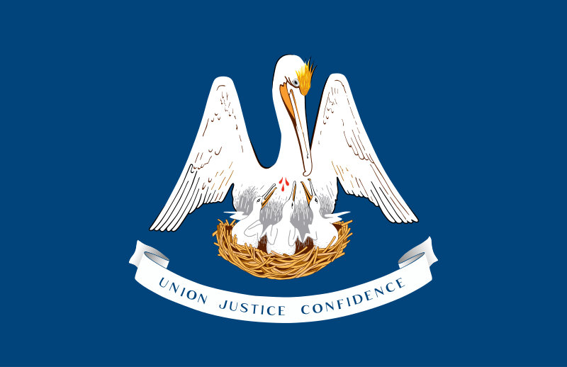
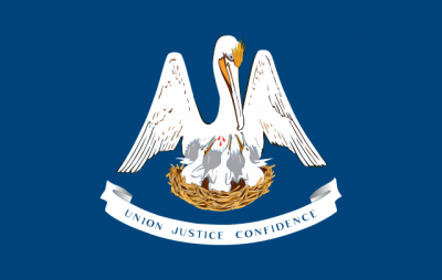
Луизиа́на[1][2] (англ. Louisiana; фр. Louisiane; исп. Luisiana) — штат[3] на юге США, 18-й штат, вошедший в Союз. Столица — Батон-Руж, крупнейший город — Новый Орлеан. Общая площадь 135 382 км² (31 место в США), в том числе на сушу приходится 113 721 км². Население 4 574 836 человек (25 место в США). Официальное прозвище Луизианы — «Штат пеликанов». Названа в честь французского короля Людовика XIV (во французском произношении Луи).
В прошлом Луизианой называлась обширная территория вблизи побережья Мексиканского залива, контролировавшаяся французами (см. Новая Франция). После Луизианской покупки южная часть этой территории составила штат с одноименным названием.

Minneapolis [ˌmɪnɪˈæpəlɪs] ist mit rund 430.000 Einwohnern die bevölkerungsreichste Stadt im US-Bundesstaat Minnesota. Zusammen mit St. Paul bildet sie die Metropolregion der Twin Cities mit über 3,6 Millionen Einwohnern (Stand 2020).
Der Name der Stadt entstammt einer Wortkombination aus zwei Sprachen, dem Wort der Dakota-Indianer für Wasser („minne“) und dem griechischen Wort für Stadt („polis“).
明尼阿波利斯(英语:Minneapolis)是美国明尼苏达州最大的城市,该州东南部亨内平县的县治[4]。该市位于密西西比河的两岸,明尼苏达河与密西西比河汇流点以北,紧邻明尼苏达州首府圣保罗,两市合称“双子城”,一同构成明尼阿波利斯—圣保罗都会区的核心。该都会区拥有约380万居民,位列美国第14大都市区[1]。在2014年,明尼阿波利斯城市人口估计为407,207人,是美国第46大城市和明尼苏达州最大的城市[5]。
明尼阿波利斯是一个水资源丰富的城市,拥有20处湖泊和湿地、密西西比河河滨,以及众多的溪流与瀑布。
明尼阿波利斯在历史上曾是世界的面粉工业之都和重要的伐木业中心,如今,该市仍然是芝加哥与西雅图之间广阔区域最重要的商业中心。[6]明尼阿波利斯也拥有众多吸引着创作者与观众的文化机构,涉及戏剧、视觉艺术、文学和音乐各个领域,其中著名的格斯里剧院是纽约百老汇以外的地方剧院的先驱。该市还拥有多样化的人口,长期以来形成了通过公共社会改良规划或私人的善举来支持慈善事业的传统。明尼阿波利斯也是公共园林系统的典范,每个家庭到公园的距离都在800米之内。
该市名称“Minneapolis”的命名者是该市第一位学校教师,他将拉科塔语中表示水的词“mni”和希腊语表示城市的词“polis”组合成该市的名称。[7][8]明尼阿波利斯的绰号是“湖城(City of Lakes)”和“面粉城(Mill City)”[6]。


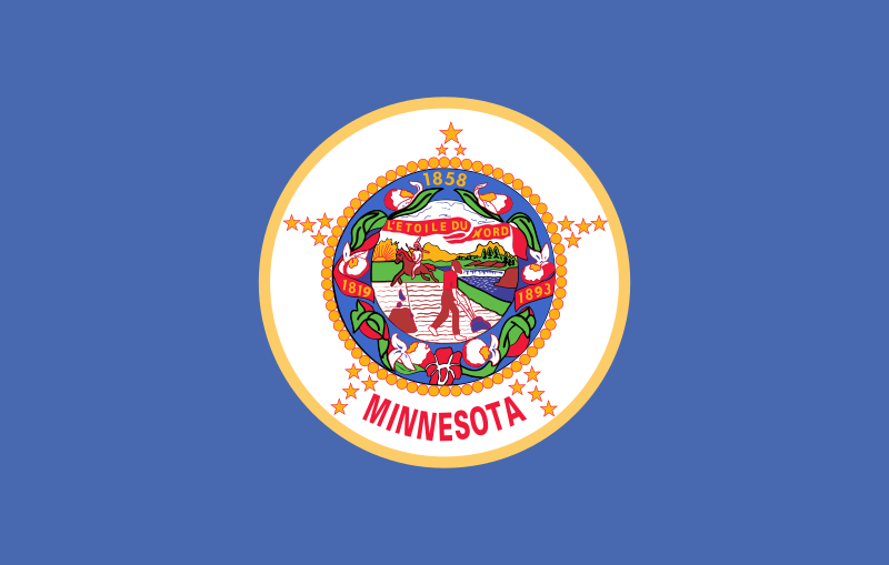
明尼苏达州(英语:State of Minnesota)是美国第32个州,于1858年5月11日加入联邦。
明尼苏达州是美国中西部最大的一个州,属于上中西部地区。明尼苏达州最重要的城市地区是由明尼阿波利斯和圣保罗组成的双城地区,这两座城市以及它们周围的城区里的居民占明尼苏达州总居民数的一半以上。 明尼苏达州有“万湖之州”和“冰球之州”的称呼[1]。 明尼苏达州是美国重要的粮食产区之一。它还拥有许多自然财富,这些财富在过去两个世纪中被大量开采。
Minnesota (Aussprache [ˌmɪnɪˈsoʊ̯ɾə]; von Mnísota „trübes Wasser“ aus der Sioux-Sprache Dakota; Abkürzung: MN oder Minn.) ist der 32. Bundesstaat der Vereinigten Staaten von Amerika. Der flächenmäßig zwölftgrößte US-Bundesstaat liegt im Norden des Landes an der Grenze zu Kanada. Er entstand 1858 aus dem östlichen Teil des Minnesota-Territoriums und einem kleinen Teil des Wisconsin-Territoriums.
Mehr als die Hälfte der Bevölkerung Minnesotas lebt in der Metropolregion Minneapolis-Saint Paul (Twin Cities), wobei Minneapolis mit knapp 383.000 Einwohnern die bevölkerungsreichste Stadt des Bundesstaates ist. St. Paul – als zweitgrößte Stadt mit ca. 285.000 Einwohnern – ist aber die Hauptstadt. In den Zwillingsstädten haben einige große, international tätige Unternehmen ihren Sitz. Des Weiteren befindet sich auch das größte Einkaufszentrum der USA, die Mall of America, in jener Metropolregion, nämlich in der Stadt Bloomington.
Minnesota trägt – abgeleitet von seinem Staatsmotto („L’Étoile du Nord“, frz. für „Stern des Nordens“) – den Beinamen North Star State (engl. „Nordsternstaat“). Ein weiterer Spitzname des Staates ist The Gopher State. Gopher nennt man insbesondere in Minnesota das dort weit verbreitete Dreizehnstreifen-Hörnchen, das zunächst nur Namensgeber und Maskottchen der meisten Sportteams der University of Minnesota war („Golden Gophers“) und erst später auch zur Bezeichnung für den ganzen Staat wurde.[2] Trotz zweier Gesetzesinitiativen wurde das Streifenhörnchen nicht zum offiziellen Wappentier Minnesotas.[3] Aufgrund seiner vielen Seen wird Minnesota auch „Land der zehntausend Seen“ genannt.[4]
ミネソタ州(英: State of Minnesota [ˌmɪnᵻˈsoʊtə] (![]() 音声ファイル))は、アメリカ合衆国中西部の北、カナダに接する州である。アメリカ合衆国50州の中で、陸地面積では第12位、人口では第21位である。前身のミネソタ準州から1858年5月11日に合衆国32番目の州に昇格した。東側はウィスコンシン州に、西側はノースダコタ州とサウスダコタ州に、南側はアイオワ州に接している。州の北東部はスペリオル湖に接し、ミシシッピ川は州北西部から南東に向かって流れ、州南東部ではウィスコンシン州との州境を構成している。
音声ファイル))は、アメリカ合衆国中西部の北、カナダに接する州である。アメリカ合衆国50州の中で、陸地面積では第12位、人口では第21位である。前身のミネソタ準州から1858年5月11日に合衆国32番目の州に昇格した。東側はウィスコンシン州に、西側はノースダコタ州とサウスダコタ州に、南側はアイオワ州に接している。州の北東部はスペリオル湖に接し、ミシシッピ川は州北西部から南東に向かって流れ、州南東部ではウィスコンシン州との州境を構成している。
州都はセントポール市である。ミシシッピ川を挟んだ隣の都市であるミネアポリス市と合わせて「ツインシティーズ(双子の都市)」と呼ばれている。州人口の60%近くがこの都市圏に住んでおり、交通、事業、工業、教育、行政の中心である。州西部にあったプレーリーは農業用地に変えられ、南東部にあった落葉樹林も伐採され農業に使われている。人口の少ない北部森林地帯は鉱業、林業およびレクリエーションに使われている。
社会と政治の方向が比較的多様なことで知られ、市民の意識は高く、投票率も高い。健康管理で評価され、識字率も高い。住民の大半は北欧とドイツから移民してきた人々の子孫である。スカンディナヴィア系アメリカ人文化の中心としても知られる。近年は民族も多様化し、アジア系、アフリカ系、ラテン系の移民が増えて、ヨーロッパ系住民および元々のインディアンと混じり合っている。
Minnesota (/ˌmɪnɪˈsoʊtə/ (![]() listen)) is a state in the Upper Midwest, Great Lakes, and northern regions of the United States. Minnesota was admitted as the 32nd U.S. state on May 11, 1858, created from the eastern half of the Minnesota Territory. The state has many lakes, and is known as the "Land of 10,000 Lakes". Its official motto is L'Étoile du Nord (French for The Star of the North).
listen)) is a state in the Upper Midwest, Great Lakes, and northern regions of the United States. Minnesota was admitted as the 32nd U.S. state on May 11, 1858, created from the eastern half of the Minnesota Territory. The state has many lakes, and is known as the "Land of 10,000 Lakes". Its official motto is L'Étoile du Nord (French for The Star of the North).
Minnesota is the 12th largest in area and the 22nd most populous of the U.S. states. Nearly 55% of its residents live in the Minneapolis–Saint Paul metropolitan area (known as the "Twin Cities"),[8] the state's main hub of transportation, business, industry, education, and government. Urban centers in "Greater Minnesota" include Duluth, Mankato, Moorhead, Rochester and St. Cloud.[9] The state's geography is defined by western prairies now given over to intensive agriculture; deciduous forests in the southeast, now partially cleared, farmed, and settled; and the less populated North Woods, used for mining, forestry, and recreation.
For thousands of years before Europeans arrived, Minnesota was inhabited by various indigenous peoples. French explorers, missionaries, and fur traders began exploring the region in the 17th century, encountering the Dakota and Ojibwe/Anishinaabe tribes. Much of what is now Minnesota was part of the vast French holding of Louisiana, which the United States purchased in 1803. After several territorial reorganizations, Minnesota was admitted into the Union in 1858. Like many Midwestern states, it remained sparsely populated and centered on lumber and agriculture.
During the mid-19th and early 20th centuries, European immigrants began settling Minnesota. Many of them came from Scandinavia, Germany, and Central Europe (e.g., Czechs and Slovaks). Minnesota remains a center of Scandinavian American, German American, and Czech American[10] culture (e.g., Kolach Days in Montgomery and Bohemian Flats in Minneapolis).[11] Historical evidence suggests that many people immigrated to Minnesota as a result of the failed European Revolutions of 1848.[12]
Minnesota's standard of living index is among the highest in the United States, behind only Massachusetts and Connecticut, and the state is among the best-educated and wealthiest in the nation.[13] In recent years, its economy has greatly diversified, shifting from traditional industries such as agriculture and resource extraction to services and finance. While Minnesota's population is still mostly Scandinavian- and German-American, domestic migration and immigration from Asia, the Horn of Africa, the Middle East, and Latin America have broadened its demographics.
Le Minnesota /minesɔta/3 Écouter (en anglais : /ˌmɪnɪˈsoʊtə/4 Écouter ou /ˌmɪnɪˈsoʊɾə/5 Écouter) est un État du Midwest des États-Unis, bordé à l’ouest par le Dakota du Nord et le Dakota du Sud, au nord par les provinces canadiennes du Manitoba et de l'Ontario, à l’est par le lac Supérieur et le Wisconsin et au sud par l’Iowa.
Il Minnesota (AFI: minneˈzɔta[2]; in inglese [mɪnɨˈsoʊtə]) è il trentaduesimo Stato federato degli Stati Uniti d'America (ne è entrato a far parte l'11 maggio 1858), e conta al 2018 una popolazione di 5.679.718 abitanti. La capitale è Saint Paul (307.695), ma la città più popolosa è Minneapolis (425.403 abitanti); altri centri rilevanti sono Duluth (86.277 abitanti), Rochester (99.121 abitanti) e Bloomington (81.446 abitanti). La superficie è di 225.181 km², gran parte dei quali occupati dall'acqua di laghi e fiumi, inclusa una parte del Lago Superiore.
Situato in posizione centro-settentrionale, e confinante con Canada, Nord Dakota e Sud Dakota, Iowa e Wisconsin, il Minnesota è conosciuto come la terra dei 10.000 laghi (in realtà sono quasi 12.000). Oltre a questi conta 6.500 fra torrenti e fiumi, fra cui l'omonimo Minnesota e il Mississippi, che sfociano in tre diverse direzioni: Baia di Hudson in Canada a nord, Oceano Atlantico a est e Golfo del Messico a sud. Secondo un'antica leggenda prende il nome dal vocabolo della lingua dakota minisota, cioè "acqua che riflette il cielo".
Per la sua posizione geografica il Minnesota ha un clima che, nella stessa stagione, varia sensibilmente da settentrione a meridione. Ugualmente differenziato è il territorio, con praterie e fertili pianure a ovest e a sud, e ricco di boschi di conifere a nord e folte foreste a est (la parte un tempo conosciuta come Big Wood).
Minesota (en inglés: Minnesota) es uno de los cincuenta estados que, junto con Washington D. C., forman los Estados Unidos de América. Su capital es Saint Paul y su ciudad más poblada, Mineápolis. Está ubicado en la región Medio Oeste del país, división Centro Noroeste. Limita al norte con Canadá, al noreste con el lago Superior, al este con los ríos Misisipi y St. Croix —que forman la mayor parte de su frontera con Wisconsin—, al sur con Iowa, al suroeste con Dakota del Sur y al noroeste con Dakota del Norte. Fue admitido en la Unión el 11 de mayo de 1858, como el estado número 32.
El actual estado de Minesota fue constituido a partir de la mitad oriental del Territorio de Minesota. Su población, de más de cinco millones de habitantes, desciende fundamentalmente de emigrantes de Europa Occidental. Las minorías étnicas principales son los afroestadounidenses, los asiáticos, los hispanos, los nativos americanos descendientes de los habitantes originales, y las recientes comunidades de inmigrantes somalíes y hmong.
Poco más de la mitad de su población se concentra en el área metropolitana de las Ciudades Gemelas (EN: Twin Cities), Mineápolis y St. Paul, que son el centro estatal de transportes, negocios e industrias, y hogar de una comunidad artística internacionalmente reconocida. El resto del estado, conocido como Gran Minesota (Greater Minnesota), consiste en vastas praderas dedicadas a la agricultura intensiva al oeste, bosques caducifolios al este, y el menos poblado bosque boreal al norte. El estado es conocido también por su apodo, la «Tierra de los 10 000 lagos». Tales lagos, junto con los demás cursos de agua y sus numerosos parques y bosques nacionales ofrecen a los residentes y los turistas un vigoroso estilo de vida al aire libre.
Su clima extremo contrasta con la moderación de sus habitantes. El estado es conocido por su política de moderada a progresista, por sus políticas sociales y por su alta participación cívica en temas políticos. Figura entre los estados más sanos, y cuenta con una de las poblaciones más educadas y alfabetizadas.1
Миннесо́та[1][2] (англ. Minnesota[ˌmɪnəˈso̞ɾɐ] ![]() слушать [mɪnɨˈsoʊtə]) — штат[3] на Среднем Западе США. В штате проживает 5 420 380 человек[4] (2013, 21-е место в США), главным образом немецкого (37,3 %), норвежского (17,0 %), ирландского (12,2 %) и шведского (10,0 %) происхождения. Столицей штата является город Сент-Пол. Крупнейший город штата — Миннеаполис. Другие крупные города: Блумингтон, Дулут, Рочестер, Бруклин-Парк.
слушать [mɪnɨˈsoʊtə]) — штат[3] на Среднем Западе США. В штате проживает 5 420 380 человек[4] (2013, 21-е место в США), главным образом немецкого (37,3 %), норвежского (17,0 %), ирландского (12,2 %) и шведского (10,0 %) происхождения. Столицей штата является город Сент-Пол. Крупнейший город штата — Миннеаполис. Другие крупные города: Блумингтон, Дулут, Рочестер, Бруклин-Парк.