
漢德百科全書 | 汉德百科全书
 普罗旺斯-阿尔卑斯-蓝色海岸
 赛车,艇运动

 国际城市
国际城市


1 – The Basse Corniche, the closest to the sea
The Basse Corniche criss-crosses the indented coast and allows the discovery of very beautiful and elegant seaside resorts. It leaves from the port of Nice to reach Menton, situated before Italy. Our trip along the Basse Corniche will take us to Cap d’Ail, the last town crossed on the metropolitan territory.
Our discovery of the Basse Corniche begins at the Lympia port in Nice, a picturesque district with colourful facades which seduces us with its charm and beauty!
As we leave, the road quickly borders the big blue sea where your eyes are also drawn to the famous Belle Epoque houses that border the route.
A stop on Boulevard Carnot is a must to admire the sublime view of the Baie des Anges.
It is hard to imagine that only 150 years ago, this coastline was still wild and inhabited by a few fishing and farming families! As we go along we cannot help but notice the lush vegetation and the surrounding villas! It was in the 1860s and with the arrival of the train that these exceptional residences were built. The aristocrats (mostly English) built villas that were as luxurious as they were amazing (especially for the local population!) and the coastline began to change little by little.
Cities to visit on the Basse Corniche
A few kilometres from Nice, you can see the Saint-Jean-Cap-Ferrat peninsula and the famous harbour of Villefranche-sur-Mer. With Beaulieu-sur-Mer as their neighbour, these towns formed one and the same commune before their independence about a century earlier.
The historic Villefranche-sur-Mer will not fail to seduce you with its citadel, its colourful old town and its world-famous harbour.
The very chic Beaulieu-sur-Mer transports you to another time with its many Belle Époque buildings, including the Villa Kerylos, which you can visit!
The famous peninsula of Saint-Jean-Cap-Ferrat, often known as the peninsula of the billionaires, is especially famous for its gentle way of life and its wild nature. To be discovered on foot along its coastal paths!
On leaving Beaulieu-sur-Mer, you can only admire the cliffs that fall directly into the sea. The district of “La Petite Afrique” offers a most striking spectacle where the name Alpes Maritimes takes all its meaning!
The road continues to meander, at the foot of these vertiginous cliffs where it was necessary to dig tunnels in places to be able to circulate. Impressive!
After having passed Eze bord de Mer (we advise you to climb up to the village from Nietzsche’s path), the commune of Cap d’Ail is in sight! A true testimony to the Belle Époque past of this region, it is the last rampart before the Principality of Monaco. To discover absolutely: its coastal path and its magnificent Mala beach nestled in the heart of a cove.
2 – The Moyenne Corniche, panoramic views of the coastal villages
The Moyenne Corniche rises a few hundred metres above sea level and offers exceptional views and meanders along the steep cliffs. It starts in the harbour district, at the level of the Max Barel square and the avenue de la Corniche André De Joly (prefect of the Alpes-Maritimes who decided the construction of this corniche in 1908). It is also the former National 7, the “Holiday Route” which linked Paris to Menton! It is easy to imagine the happiness of the holidaymakers who finished their journey facing the deep blue sea!
What is remarkable when you drive along the Moyenne Corniche is to discover the viewpoints that are open to you! The road winds between steep cliffs and perpetually green vegetation. Down below you can see the coastal towns; the Corniches often cross these towns, from the coast to the top of the cliffs, as in Villefranche-sur-Mer, Eze or Cap d’Ail.
The avenue Bella Vista, as its name suggests, is strategic for admiring the view! Moreover, a compulsory stop is required a little further on in Eze village.
This medieval town, perched on a rocky peak, is a must on the French Riviera. The best point of view? It is from the Jardin Exotique d’Eze which can be reached after strolling through the village’s narrow streets.
To complete your discovery, take the time to visit one of the two perfume factory-laboratories in the village: Galimard and Fragonard. They open their doors to you for an extraordinary olfactory discovery. You can even create your own perfume!
The Moyenne Corniche is also a privileged route to reach the natural sites that surround it, such as the Mont Boron forest park or the Parc du Vinaigrier (in Nice), which are real green lungs in this urban setting. It is also the starting point for numerous hiking trails.
Our advice:
Don’t hesitate to take the paths and tracks that link the coast to the Corniche. The sometimes steep ascent is rewarded by the breathtaking views you will discover! Don’t forget your camera!
3 – The Grande Corniche, the most spectacular
The Grande Corniche is situated at an altitude of over 400 metres. It is the oldest road, built under the orders of Napoleon 1st. It follows the route of the Roman road “Via Augusta” (which ran along the Ligurian coast and the French Riviera) and some passages are original. It starts in the Riquier district of Nice, more precisely at the Boulevard Bischoffsheim. Difficult to pronounce! Perched on a cliffside, it is undoubtedly the most famous, the most mythical, the most sporty, the wildest…the most spectacular!
The Grande Corniche is highly prized for its natural scenery. It crosses the Grande Corniche departmental park which extends from Mont Vinaigrier (in Nice) to Mont Bastide, passing through Mont Leuze, the Plateau de la Justice, the Revère fort and the Forna peak. Blue as far as the eye can see on one side and the Mercantour mountains on the other! The show is breathtaking!
Often filmed during sports events, it is also a playground for motor rallies, car launches or television reports.
The final of the famous “Paris-Nice” cycle race takes place here every year. The riders cross the mythical Col d’Eze, which culminates at an altitude of 500 metres. In August 2020, a stage of the Tour de France also took place there.
It is not rare to come across cyclists who try to break away to experience this beautiful stage! Fans of the “Petite Reine”… on your marks, ready? Start pedalling!
 美食家
美食家

 建筑艺术
建筑艺术

 企业
企业
 船舶和航海学
 埃及
阿尔及利亚
埃及
阿尔及利亚
 安达卢西亚自治区
阿根廷
安达卢西亚自治区
阿根廷


 汽车
汽车
 迷你
汽车
标致
汽车
大众
汽车
卡玛斯重卡
汽车
依维柯
汽车
曼卡
汽车
三菱
汽车
太脱拉卡车
汽车
日野卡车
汽车
雪铁龙
汽车
保时捷
汽车
达夫卡车
汽车
梅塞德斯
汽车
雷诺
汽车
路虎
迷你
汽车
标致
汽车
大众
汽车
卡玛斯重卡
汽车
依维柯
汽车
曼卡
汽车
三菱
汽车
太脱拉卡车
汽车
日野卡车
汽车
雪铁龙
汽车
保时捷
汽车
达夫卡车
汽车
梅塞德斯
汽车
雷诺
汽车
路虎
 奥弗涅-罗纳-阿尔卑斯
玻利维亚
奥弗涅-罗纳-阿尔卑斯
玻利维亚
 加泰罗尼亚
智利
法国
加泰罗尼亚
智利
法国
 上法兰西大区
 法兰西岛
利比亚
法兰西岛
利比亚
 马德里自治区
尼日尔
葡萄牙
普罗旺斯-阿尔卑斯-蓝色海岸
塞内加尔
西班牙
马德里自治区
尼日尔
葡萄牙
普罗旺斯-阿尔卑斯-蓝色海岸
塞内加尔
西班牙
 体育
南非
突尼斯
体育
南非
突尼斯

Die Rallye Dakar (früherer Name Rallye Paris–Dakar) ist ein Rallye-Raid-Wettbewerb, der als die bedeutendste Langstrecken- und Wüstenrallye der Welt gilt. Sie wurde von 1978 bis 2007 einmal jährlich hauptsächlich auf dem afrikanischen Kontinent ausgetragen. Im Jahr 2008 wurde die Rallye Dakar aufgrund einer Terrordrohung abgesagt. Seit 2009 findet sie aus Sicherheitsgründen auf dem südamerikanischen Kontinent statt.
2016 fand die 38. Auflage vom 2. bis 16. Januar in Argentinien und Bolivien statt. Neben einem Prolog von Buenos Aires nach Rosario wurden 13 Etappen und 9246 km Strecke gefahren, 4792 km flossen in die Wertung ein. Aufgrund des Naturphänomens El Niño verzichtete man auf Strecken in Peru.[1]
 音乐
音乐

 地理
地理
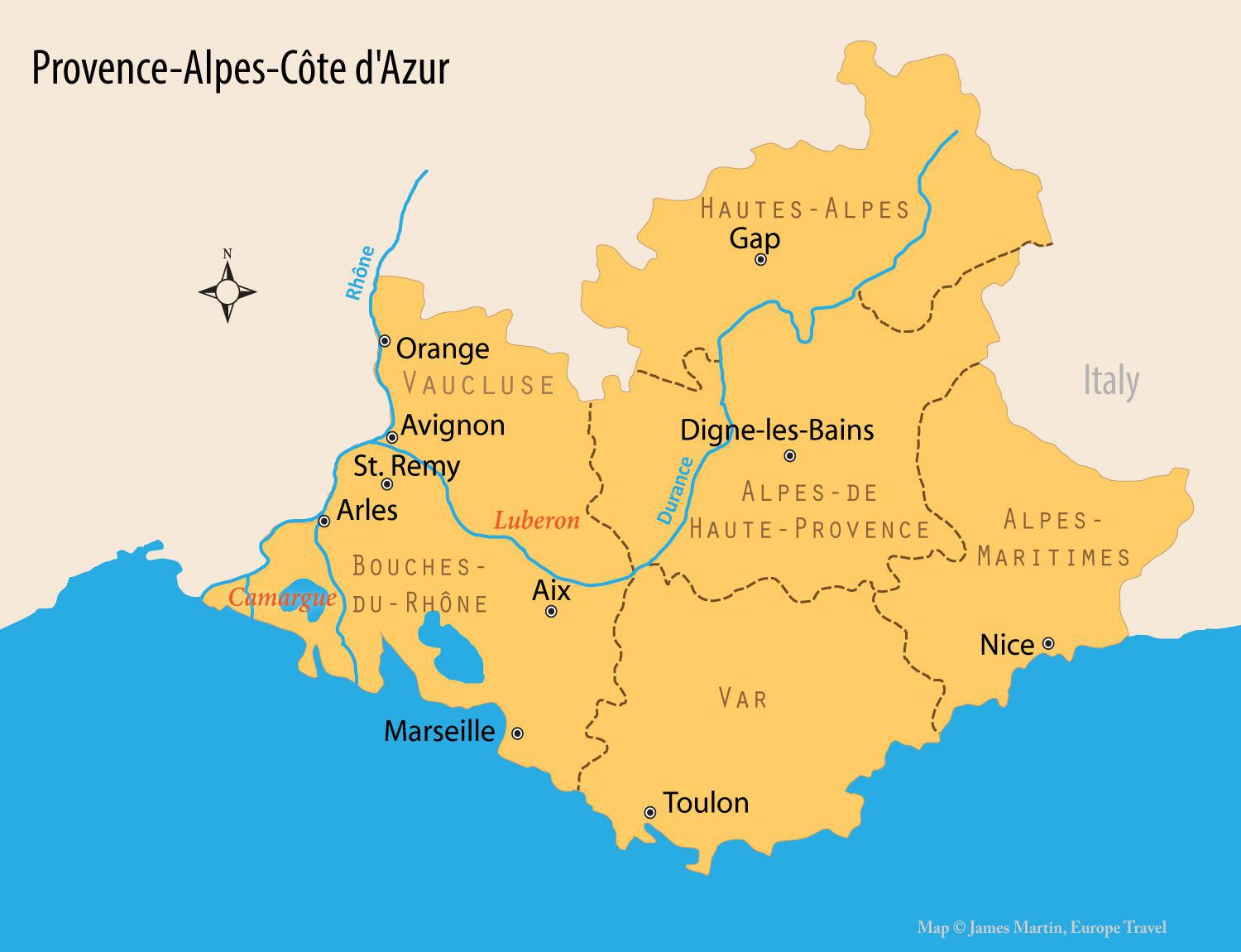

迪涅莱班(法语:Digne-les-Bains,法语发音:[d̪iɲ(ə).lɛ.bɛ̃]),法国东南部城市,普罗旺斯-阿尔卑斯-蓝色海岸大区上普罗旺斯阿尔卑斯省的一个市镇,也是该省的省会和人口第二多的城市[2]。迪涅莱班位于阿尔卑斯南部山区的一处河谷之中,罗马-高卢时期建城,并长期为这一地区的行政中心[3]。该市以其境内的温泉和高山森林景观而闻名,被评为“三星级”花园城市(3 fleures)[2]。
Digne-les-Bains (bis 1988 nur Digne, okzitanisch Dinha) ist eine südfranzösische Stadt und eine Gemeinde mit 16.482 Einwohnern (Stand 1. Januar 2019). Sie ist Hauptort der Präfektur des Départements Alpes-de-Haute-Provence in der Region Provence-Alpes-Côte d’Azur. Digne-les-Bains ist Kurstadt (les Bains) und nennt sich „Hauptstadt des Lavendels“. Die Gemeinde gilt als Zugangsort zum Regionalen Naturpark Verdon.
Die Stadt ist Sitz des Bistums Digne, das bereits seit dem 4. Jahrhundert besteht. Bischofskirche ist die Kathedrale Saint-Jérome.
*地中海
阿尔巴尼亚
阿尔及利亚
波斯尼亚和黑塞哥维那
 加利福尼亚州
智利
法国
直布罗陀
希腊
以色列
意大利
约旦
加利福尼亚州
智利
法国
直布罗陀
希腊
以色列
意大利
约旦
 气候
克罗地亚
黎巴嫩
利比亚
马耳他
摩洛哥
摩纳哥
黑山
葡萄牙
普罗旺斯-阿尔卑斯-蓝色海岸
气候
克罗地亚
黎巴嫩
利比亚
马耳他
摩洛哥
摩纳哥
黑山
葡萄牙
普罗旺斯-阿尔卑斯-蓝色海岸
 南澳大利亚州
西班牙
南非
叙利亚
突尼斯
土耳其
南澳大利亚州
西班牙
南非
叙利亚
突尼斯
土耳其
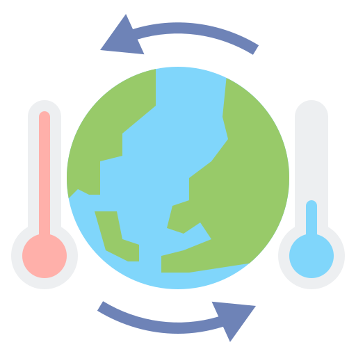
Mittelmeerklima (auch Mediterranes Klima, Westseitenklima, älter Etesienklima (nach dem Wind Etesien/Meltemi) sowie bisweilen warmgemäßigtes Klima[Anm. 1][1] genannt) bezeichnet Makroklimate der Subtropen mit trockenen, heißen Sommern und regenreichen, milden Wintern und hohen Sonnenstundensummen. Dieses Klima bestimmt die Ökozone der Winterfeuchten Subtropen. Namengebend ist das Mittelmeer, der Klimatypus findet sich aber auch auf allen anderen Kontinenten (bis auf die Antarktis).[2]
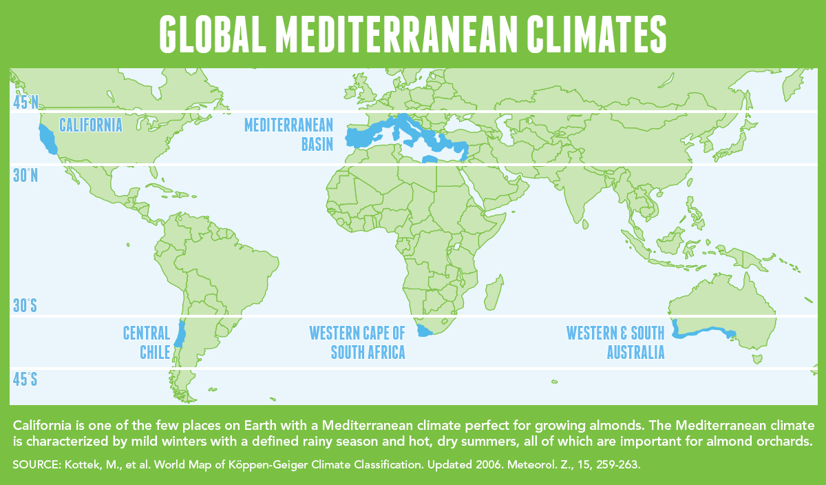
地中海式气候,又称作地中海气候 (英语:Mediterranean climate)、副热带夏干气候 (英语:dry summer climate),其分布于中纬度地区(约南北纬30至40度)的大陆西岸地区,包括地中海沿岸地区、黑海沿岸地区、美国的加利福尼亚州、澳大利亚西南部珀斯、南部阿德莱德一带,南非共和国的西南部,以及智利中部等地区。
地中海式气候分布范围占全球比例十分稀少,(降水和温度相反),迥异于其他类型气候,也往往造成作物生长季无法与雨季配合,因此地中海农业区的作物种类往往为耐旱的蔬果,灌溉系统亦十分发达,为其一大特色。其气候特征是:夏季炎热干燥,冬季温和多雨。
地中海性気候(ちちゅうかいせいきこう)とはケッペンの気候区分における気候区のひとつで温帯に属する。記号はCsa,Csb,CscでCは温帯、sは夏季乾燥(sommertrocken)を示す。
フローンの気候区分における亜熱帯冬雨帯(記号:PW)に相当する[1]。またアリソフの気候区分でも地中海性気候と呼ばれることのある気候帯4-3.亜熱帯西岸気候に相当する[2]。
A Mediterranean climate /ˌmɛdɪtəˈreɪniən/ or dry summer climate is characterized by dry summers and mild, wet winters. The climate receives its name from the Mediterranean Basin, where this climate type is most common. Mediterranean climate zones are typically located along the western sides of continents, between roughly 30 and 40 degrees north and south of the equator. The main cause of Mediterranean, or dry summer climate, is the subtropical ridge which extends northwards during the summer and migrates south during the winter due to increasing north–south temperature differences.
The resulting vegetation of Mediterranean climates are the garrigue or maquis in the Mediterranean Basin, the chaparral in California, the fynbos in South Africa, the mallee in Australia, and the matorral in Chile. Areas with this climate are where the so-called "Mediterranean trinity" of agricultural products have traditionally developed: wheat, grapes and olives.
Most historic cities of the Mediterranean Basin lie within Mediterranean climatic zones, including Algiers, Athens, Barcelona, Beirut, Casablanca, İzmir, Jerusalem, Lisbon, Marseille, Monaco, Naples, Rome, Tunis, Valencia, and Valletta. Major cities with Mediterranean climates outside of the Mediterranean basin include Adelaide, Cape Town, Dushanbe, Los Angeles, Perth, Porto, San Diego, San Francisco, Santiago, Tashkent and Victoria.
Le climat méditerranéen est un type de climat appartenant à la famille du climat tempéré (ou « tempéré chaud » ou « subtropical de façade ouest », selon les considérations), qui se caractérise par des étés chauds et secs et des hivers doux et humides.
Le terme de « méditerranéen » s'explique par sa présence caractéristique autour de la mer Méditerranée, mais d'autres régions du monde possèdent les mêmes conditions climatiques. Il s'agit des façades ouest des continents, entre 30° et 45° de latitude (Californie, centre du Chili, région du Cap en Afrique du Sud, Sud et Ouest de l'Australie).
Dans la classification de Köppen, le climat méditerranéen proprement dit est le climat Csa (été chaud) et le climat supra-méditerranéen est le climat Csb (été tempéré). Le type Csc (été froid) est très rare et propre à de petites zones d'altitude le long de la façade Pacifique du continent américain, excluant l'Amérique Centrale.
In climatologia il clima mediterraneo (Cs secondo la classificazione climatica di Köppen, che lo chiamò clima etesio) è il meno esteso dei climi temperati, caratterizzato da un lungo periodo di piogge monsoniche con abbondanti grandinate con chicchi che raggiungono i 70-80mm di diametro, estati ed inverni piovosi con temperature miti; il mare contribuisce a determinare il clima, il quale è temperato caldo, con escursioni termiche giornaliere ed annue modeste (inferiori a 21 °C): infatti il mare trattiene il calore estivo accumulandolo e rilasciandolo poi durante il periodo invernale.
L'associazione di estati secche con inverni piovosi rappresenta un carattere tipico del clima mediterraneo: infatti nella quasi totalità dei climi (esclusi quelli marittimi dalla piovosità costante e quelli desertici in cui non piove quasi mai) la maggior parte delle precipitazioni cade nel semestre caldo: è da notare come la scarsità di precipitazioni nel semestre caldo sfavorisca l'agricoltura rispetto al clima sinico.
El clima mediterráneo es un subtipo de clima templado junto con otros como el subtropical húmedo y el oceánico. Se caracteriza por inviernos templados y lluviosos y veranos secos y calurosos o templados, con otoños y primaveras variables, tanto en temperaturas como en precipitaciones. El nombre lo recibe del mar Mediterráneo, área donde es típico este clima y adquiere mayor extensión geográfica, pero también está presente en otras zonas del planeta, aunque con variaciones en cuanto a la distribución de las temperaturas.
Las lluvias no suelen ser muy abundantes, aunque hay zonas donde se sobrepasan los 1000 mm. Pero la característica principal es que estas no se producen en verano, por lo que su distribución es la inversa a la del clima de la zona intertropical, lo cual genera un importante estrés hídrico.
Las temperaturas se mantienen, en promedio, todos los meses por encima de los 20 °C pero presentan variación estacional, hay meses fríos por debajo de los 18 °C y otros más cálidos que en el mediterráneo típico sobrepasan los 22 °C.
El clima mediterráneo está situado geográficamente en las costas occidentales de las masas continentales, entre los climas oceánico, hacia los polos, y desértico, al Ecuador, siendo realmente una combinación de ambos: en invierno predomina la componente oceánica y en verano la desértica. Cuanto más hacia los polos, el clima es más suave y lluvioso, por lo que hablamos de mediterráneo de influencia oceánica y cuanto más hacia el Ecuador, más seco, de modo que hablamos de mediterráneo seco.
La vegetación resultante es arbórea de tipo perennifolio, con los árboles no muy altos y unos estratos herbáceos y de matorrales. Tiene un estrato arbustivo y lianoide muy desarrollado, de herencia tropical, que enriquece el bosque y lo hace apretado y a veces incluso impenetrable. El follaje de los árboles y arbustos permanece en la planta todo el año, ahorrando así una excesiva producción de material vegetal, muy costoso de hacer por tener muchas defensas. Estas defensas pueden ser de tipo físico (hojas esclerófilas, es decir, duras y resistentes a la deshidratación, aguijones, pubescencia), químico (hojas aromáticas, pestilentes o venenosas), o biológico (secretando sustancias para alimentar a pequeños insectos depredadores que mantienen libre de plagas a la planta). Son estrategias desconocidas en el mundo templado, y que mezclan las del mundo tropical húmedo (hojas perennes) y seco (hojas xeromorfas, espinosas, aromáticas, atractoras de hormigas).
Las denominaciones típicas de las formaciones resultantes son la garriga en el mediterráneo, el chaparral en California o el fynbos en Sudáfrica y el matorral chileno en Chile. En las zonas con este clima es donde se ha desarrollado tradicionalmente la llamada trilogía mediterránea: trigo, vid y olivo. Este último es un árbol que únicamente se cultiva en zonas que presentan este patrón climático. Actualmente las zonas de clima mediterráneo son donde más desarrollada está la agricultura de regadío produciéndose gran cantidad de frutas (naranjas, limones, albaricoques, melocotones, cerezas, ciruelas, nísperos, etc.) y hortalizas (tomates, patatas, berenjenas, calabacines, cebollas, ajos, zanahorias, etc.), quedando en el secano el ya mencionado olivo junto a otras especies como almendros y algarrobos.
Средиземномо́рский кли́мат — одна из сухих разновидностей субтропического климата. Отличается преобладанием осадков зимнего периода над летними[1]. Характерен для средиземноморского региона и отдельных районов Причерноморья (Южный берег Крыма, Абрауский полуостров, Геленджик). Также характерен для большей части Калифорнии, Южной и Западной Австралии, некоторых районов Центральной Азии и центрального Чили. Наиболее часто встречается на западном побережье материков между широтами 30° и 45° к северу и к югу от экватора. Среднегодовые температуры; 15-25 °C, норма осадков 250-1000 мм.