Deutsch-Chinesische Enzyklopädie, 德汉百科
 Yunnan Sheng-YN


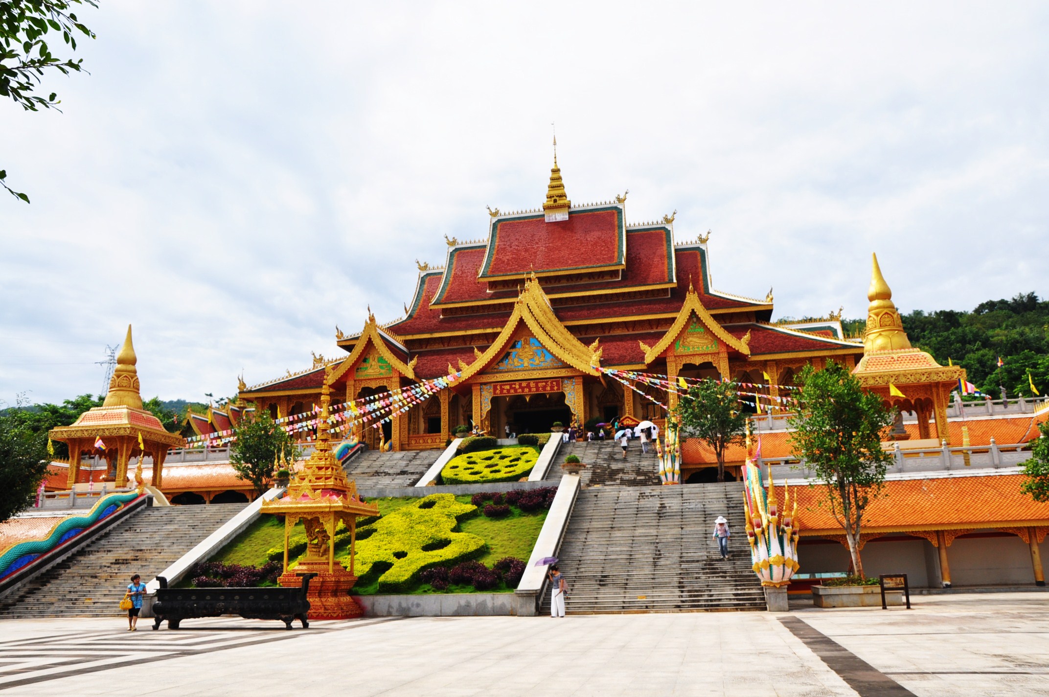
Das Kloster Ganden Songtsenling (Tibetisch: དགའ་ལྡན་སུམ་རྩེན་གླིང་, Wylie: dga' ldan sum rtsen gling; chinesisch 噶丹松赞林寺, Pinyin Gádān Sōngzànlín Sì, englisch Songzanlin Lamasery) ist ein Kloster des tibetischen Buddhismus in Shangri-La, dem früheren Zhongdian (中甸县), im Autonomen Bezirk Dêqên[1] der Tibeter im Nordwesten der chinesischen Provinz Yunnan. Es ist das größte Kloster der Gelug-Schule des tibetischen Buddhismus in Yunnan. (Vorsicht: Es existieren viele Alternativnamen, s.u.)
1679 hatte der fünfte Dalai Lama – Ngawang Lobsang Gyatso – den chinesischen Kaiser Kangxi um die Genehmigung gebeten, hatte selbst den Ort ausgewählt, den Tempel aufgebaut und ihm seinen Namen gegeben. Qing-Kaiser Yongzheng gab ihm den chinesischen Namen Guihua-Kloster[2]. Der Tempel war die Aufenthaltsstätte bekannter tibetischer buddhistischer Mönche.
Es liegt auf dem Reiseweg vieler Touristen nach Tibet. Auch die Grenze zur Provinz Sichuan liegt in seiner Nähe.
 Gansu Sheng-GS

 History
 Qinghai Sheng-QH
 Sichuan Sheng-SC
 Xinjiang Uygur Zizhiqu-XJ
 Xizang Zizhiqu-XZ
 Yunnan Sheng-YN

格萨尔王传(藏语:གེ་སར་རྒྱལ་པོ་,威利:Ge-sar rgal-po,蒙古语:ᠭᠡᠰᠡᠷ
ᠬᠠᠭᠠᠨ),流行在西藏和中亚地区的著名史诗,目前在西藏、蒙古和土族中间尚有140位演唱艺人在说唱这部史诗。
格萨尔王传已经存在有一千多年,长达60万诗行,相当于印度史诗《摩诃婆罗多》3部长,《罗摩衍那》15部,是世界最长的史诗。讲述传说中的岭国国王格萨尔的故事,对藏传佛教影响很大。
格萨尔王传在目前有多达五十多种不同的版本,但仅中国大陆发行的藏文版本就已达到120册,分29章。而第一个印刷发行的版本是1716年,在北京发布的蒙古文版。
Gesar[1] ist ein epischer tibetischer König, dessen Heldentaten in von Barden vorgetragenen Gesängen, in ihrer Gesamtheit Gesar-Epos genannt, beschrieben werden. Dieses Epos gilt als der größte zentralasiatische Epenzyklus.
Dieses Korpus von Erzählungen enthält das Grundmotiv vom Kampf des guten tibetischen Herrschers Gesar, der als Mensch geboren wird, jedoch viele göttliche Fähigkeiten hat, gegen das Böse in der Welt. Gesars kriegerische und listenreiche Taten werden in ganz Zentralasien von Ladakh bis in die Mongolei, besonders aber in Osttibet, in Form von Gesängen tradiert, daher wird es meist Gesar-Epos genannt. Es existiert unter anderem in tibetischer, mongolischer (ᠭᠡᠰᠡᠷ
ᠬᠠᠭᠠᠨ ᠤ
ᠲᠤᠭᠤᠵᠢ, Гэсэрийн тууж) und türkischer Sprache. Die Vortragenden waren und sind z. T. noch spezielle Gesar-Barden, die teilweise Texte im Umfang dicker Bücher memorieren können.
Das Epos ist sehr umfangreich und nimmt seinen Anfang mit der Entstehung der Welt. Es wurde wahrscheinlich für eine Aufführung über mehrere Tage hinweg konzipiert.
The Epic of King Gesar[a] (/ˈɡɛzər, ˈɡɛs-/), also spelled Geser (especially in Mongolian contexts) or Kesar (/ˈkɛzər, ˈkɛs-/), is an epic cycle, of Tibet and greater Central Asia, believed to date from the 12th century, that relates the heroic deeds of the culture hero Gesar,[1] the fearless lord of the legendary kingdom of Ling (Wylie: gling). It is recorded variously in poetry and prose, through oral poetry performance, [2] it is sung widely throughout Central Asia and North East of South Asia. Its classic version is to be found in central Tibet.[3] Some 100 bards of this epic (Wylie: sgrung, "tale")[4] are still active today in the Gesar belt of China.[5] Tibetan, Mongolian, Buryat, Balti, Ladakhi and Monguor singers maintain the oral tradition and the epic has attracted intense scholarly curiosity as one of the few oral epic traditions to survive as a performing art. Besides stories conserved by such Chinese minorities as the Bai, Naxi, the Pumi, Lisu, Yugur[6] and Salar,[7] versions of the epic are also recorded among the Balti of Baltistan, the Burusho people of Hunza and Gilgit[6] and the Kalmyk and Ladakhi peoples,[8][9] in Sikkim, Bhutan, Nepal, and among various Tibeto-Burmese, Turkic, and Tungus tribes.[10] The first printed version was a Mongolian text published in Beijing in 1716.[11]
The epic is composed of a very large body of versions, each with many variants, and is reputed by some to be the longest in the world.[4] Although there is no one definitive text, the Chinese compilation so far of just its Tibetan versions has filled some 120 volumes, more than one million verses,[4] divided into 29 "chapters".[12] Western calculations speak of more than 50 different books edited so far in China, India and Tibet.[4]
L'épopée du roi Guésar — dit aussi Gesar Khan ou Gesar de Ling — est le poème épique le plus célèbre des populations tibétaines1, et mongoles.
Elle comporterait plusieurs millions de vers, ce qui en ferait l'œuvre littéraire la plus longue actuellement connue dans le monde. Composée il y a plus de huit siècles à partir de récits beaucoup plus anciens, elle est encore interprétée de nos jours par plusieurs dizaines de bardes dans les régions de populations tibétaines et mongoles.
L'épopée est inscrite au Patrimoine culturel immatériel de l'humanité depuis 2009 par l'UNESCO2.
L’Epica di Re Gesar, anche scritto Geser (particolarmente in contesti mongoli) o Gesser o Kesar, è un ciclo epico, ritenuto risalire al XII secolo, che racconta le gesta dell'eroe culturale Gesar [1], impavido signore del leggendario regno di Ling. Composto in varie forme di poesia e prosa aventi come stile tipico di rappresentazione lo shuochang cinese[2] e cantato in molte zone dell'Asia centrale e del nord est dell'Asia meridionale, la sua versione classica è rintracciabile nel Tibet centrale.[3] Un centinaio di bardi di questa narrazione epica[4] sono tuttora attivi nella cosiddetta "cintura Gesar" della Cina[5]. La tradizione è mantenuta viva da centinaia di cantastorie tibetani, mongoli, buriati, balti, ladakhi e tu ovvero mongour, e l'epica ha suscitato viva curiosità da parte degli studiosi come una delle poche tradizioni orali epiche sopravvissute in forma di arte performativa. Oltre agli intrecci conservati da minoranze cinesi come i bai, i naxi, i pumi, i lisu, gli iuguri[6] e i salar[7], ulteriori versioni dell'epica si riscontrano anche in Pakistan — tra i balti del Baltistan e i burúšo di Hunza e Gilgit [8], oltre che presso calmucchi e ladakhi[9][10], in Sikkim, Bhutan, Nepal, tra svariate etnie tibeto-birmane, popolazioni di lingue turche e tribù tunguse[11]. La sua prima versione stampata è stato un testo mongolo pubblicato a Pechino nel 1716.[12]
L'epica si compone di un amplissimo corpus di versioni, ciascuna delle quali a sua volta con molte varianti, e secondo alcuni sarebbe la più lunga del mondo.[13] Sebbene non esista un testo definitivo, l'attuale compilazione cinese soltanto delle versioni tibetane ha riempito 120 volumi, più di un milione di versi[14] divisi in 29 "capitoli".[15] Secondo conteggi occidentali, più di 50 libri sarebbero a questo punto pubblicati in Cina, India e Tibet.[13]
El rey Guesar es una epopeya tibetana. Es el escrito más largo del mundo, y actualmente el texto épico más antiguo que conserva vitalidad, y que se sigue recitando y ampliando oralmente hasta hoy en día.


 Energy resource

 Energy resource
 *Electrical power

 Energy resource
 Hydroelectric power plants
 Erneuerbare Energie
 Hydropower
 Sichuan Sheng-SC
 Yunnan Sheng-YN


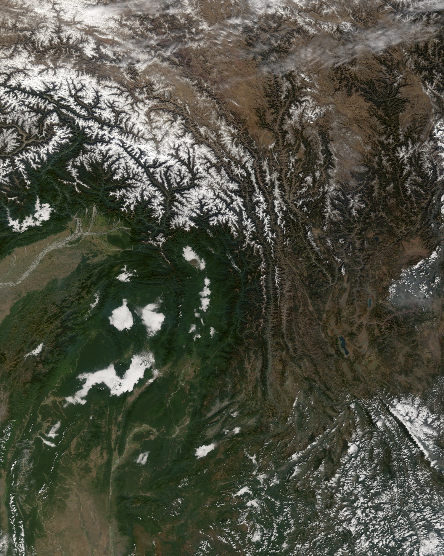
横断山脉(英文:Hengduan Mountain Range)是中国西南部的著名山脉,有广义和狭义的区分。广义的横断山脉位于青藏高原东南部(介于北纬22°~32°05′,东经97°~103°之间),为四川省西部、云南省西北部和西藏自治区东部南北向山脉的总称,是青藏高原的边缘山系。它东起邛崃山,西抵伯舒拉岭-高黎贡山,北达昌都、甘孜至马尔康一线,南抵中缅边境的山区,面积60余万平方公里,是中国最长、最宽和最典型的南北向山系。狭义的横断山脉指三江并流地区的四条山脉,即沙鲁里山、芒康山-云岭、他念他翁山-怒山及伯舒拉岭-高黎贡山。
Hengduan Shan (chinesisch 橫斷山 / 横断山, Pinyin Héngduàn Shān), das auch Hengduan-Gebirge (橫斷山脈 / 横断山脉, Héngduàn Shānmài) genannt wird, erstreckt sich über eine Fläche von 800.000 km²[1] im Südosten des Tibetischen Hochlands in China (Asien). Sein Hauptgipfel Gongga Shan misst 7556 m.[2]
Als östliche Fortsetzung des Gebirgsknotens von Himalaya, Nyainqêntanglha mit der Teilkette des Taniantawang Shan erstreckt sich dieses Gebirge zwischen der Nord- und Ostgrenze von Myanmar und über den äußersten Südosten des Autonomen Gebiets Tibet sowie die beiden chinesischen Provinzen Yunnan und Sichuan zwischen 22° und 32°05′ N und 97° und 103° E.
Die bekanntesten Bergketten des Gebirges sind Gaoligong Shan, Nu Shan und Yun Ling, die die Oberläufe der Flüsse Irrawaddy, Saluen, Mekong und Jangtsekiang voneinander trennen.
横断山脈(おうだんさんみゃく)は中華人民共和国南西部の山脈。チベット高原(青蔵高原)の南東に位置し、四川省西部、雲南省西部、チベット自治区東部の交わるあたりを南北方向に走っている山脈の総称である。
東には邛崍(キョウライ)山脈が、西には伯舒拉嶺(ボシュラ山脈)が走り、北はチャムド(昌都)・カンゼ(甘孜)・バルカム(馬爾康)を結ぶ線に達し、南は中国とミャンマーの国境地帯にあたる。面積は60万平方キロメートル以上。中国にある南北方向の山脈のうち、最も長く、最も幅広い山脈である。
The Hengduan Mountains (simplified Chinese: 横断山脉; traditional Chinese: 橫斷山脈; pinyin: Héngduàn Shānmài) are a group of mountain ranges in southwest China that connect the southeast portions of the Tibetan Plateau with the Yunnan–Guizhou Plateau. The Hengduan Mountains are primarily large north-south mountain ranges that effectively separate lowlands in northern Myanmar from the lowlands of the Sichuan Basin. These ranges are characterized by significant vertical relief originating from the Indian subcontinent's collision with the Eurasian Plate, and further carved out by the major rivers draining the eastern Tibetan Plateau. These rivers, the Yangtze, Mekong, and Salween, are recognized today as the Three Parallel Rivers UNESCO World Heritage Site.
The Hengduan Mountains cover much of western present-day Sichuan province as well as the northwestern portions of Yunnan, the easternmost section of the Tibet Autonomous Region, and touching upon parts of southern Qinghai. Additionally, some parts of eastern Kachin State in neighbouring Myanmar are considered part of the Hengduan group. The Hengduan Mountains are approximately 900 kilometres (560 mi) long, stretching from 33°N to 25°N. Depending on extent of the definition, the Hengduan Mountains are also approximately 400 kilometres (250 mi) wide under the narrowest definition, ranging from 98°E to 102°E. The area covered by these ranges roughly corresponds with the historical region known as Kham.
The Hengduan Mountains subalpine conifer forests is a palaearctic ecoregion in the Temperate coniferous forests biome that covers portions of the mountains.
Les monts Hengduan (chinois simplifié : 横断山脉) sont un massif montagneux situé dans la partie orientale du Xinan, au Sud-Ouest de la Chine. Ils culminent à 7 556 m d'altitude au Minya Konka. Ils forment la partie sud-est du plateau tibétain au contact du bassin du Sichuan et s'étendent jusqu'à la frontière de la Birmanie. Ils couvrent approximativement la province historique du Kham.
Ces montagnes de la Chine occidentale possèdent une forêts de conifères répertoriée comme Écorégion terrestre du WWF. Elles sont considérées par le Conservation International comme un point chaud de biodiversité1. Elles abritent des espèces rares comme le panda géant dans la réserve naturelle nationale de Wolong.
I monti Hengduan (cinese semplificato: 横断山脉; cinese tradizionale: 橫斷山脈; pinyin: Héngduàn Shānmài) sono un sistema montuoso dell'Asia orientale (latitudine: 22-32° N, longitudine: 97-103° E) che forma la parte sud-orientale dell'altopiano tibetano e il confine occidentale del bacino del Sichuan. Sono situati principalmente in Cina, anche se la loro estremità meridionale costituisce la frontiera con il Myanmar (Stato Kachin). Questa vasta regione montuosa occupa la maggior parte occidentale della provincia del Sichuan, nonché l'angolo nord-occidentale dello Yunnan e la sezione orientale della Regione Autonoma del Tibet.
I monti sono situati nella regione del Kham, una delle province culturali del Tibet storico.
Las montañas Hengduan (en chino: 横断 山脉, pinyin: Hengduan Shānmài) son un sistema montañoso del Asia Oriental (latitud: 22° ~ 32°N, longitud: 97° ~ 103° E) que forma la parte sur-oriental de la meseta Tibetana y el límite oeste de la cuenca de Sichuan. Está principalmente en la República Popular de China, aunque las estribaciones meridionales forman la frontera con Birmania, con el estado Kachin. La extensa región montañosa ocupa la mayor parte occidental de la provincia de Sichuan, así como la esquina noroeste de la provincia de Yunnan y la sección oriental de la Región Autónoma del Tíbet.
Las montañas están en la región de Kham, una de las provincias culturales del Tíbet histórico. De aquí es originario el panda rojo, en peligro de extinción.1
Сино-Тибетские горы, также называются Сычуаньские Альпы и Хэндуаньшань (кит. упр. 横断山脉, пиньинь: Héngduàn Shānmài, буквально: «поперечно разломанные горы») — условно выделяемый горный регион в Китае, расположенный к востоку от Тибетского нагорья. Длина около 750 км (от верховий Хуанхэ на севере до среднего течения Янцзы), ширина до 400 км. От запада к востоку высота уменьшается от 5000—6500 м до 1000—1200 м. Самая высокая точка — гора Гонгга (7590 м). По юго-западной части гор проходит граница между Китаем и Мьянмой.
Территория, занимаемая Сино-Тибетскими горами, примерно совпадает с историко-культурным регионом, известным как Кам.
Сино-Тибетские горы не являются чётко обособленной орографической областью, а скорее представляют собой сильно расчленённую окраину Тибетского нагорья на границе с равнинами и низкогорьями Восточного Китая. Состоят из нескольких хребтов, которые разделены глубокими долинами рек Салуин, Меконг, Янцзы и их притоков (глубина ущелий достигает 3000 м). В составе гор выделяют хребты Чола, Шалулишань, Дасюэшань и Цюнлайшань.
Горы очень сейсмичны, по их восточному краю проходит разлом Лунмэньшань, в котором находился эпицентр Сычуаньского землетрясения 2008 года.
В районе Сино-Тибетских гор субтропический климат западной окраины Сычуаньской котловины резко переходит в континентальный климат Тибетского нагорья. В южной части выпадает до 1200 мм осадков, на наветренных склонах гор — более 2000 мм, к западу количество осадков снижается до 600 мм в год.
Регион Сино-Тибетских гор является ареалом находящихся под угрозой вымирания Больших панд.
 Architecture
 Religion
 Literature
 Geography