
Deutsch-Chinesische Enzyklopädie, 德汉百科
 Geography

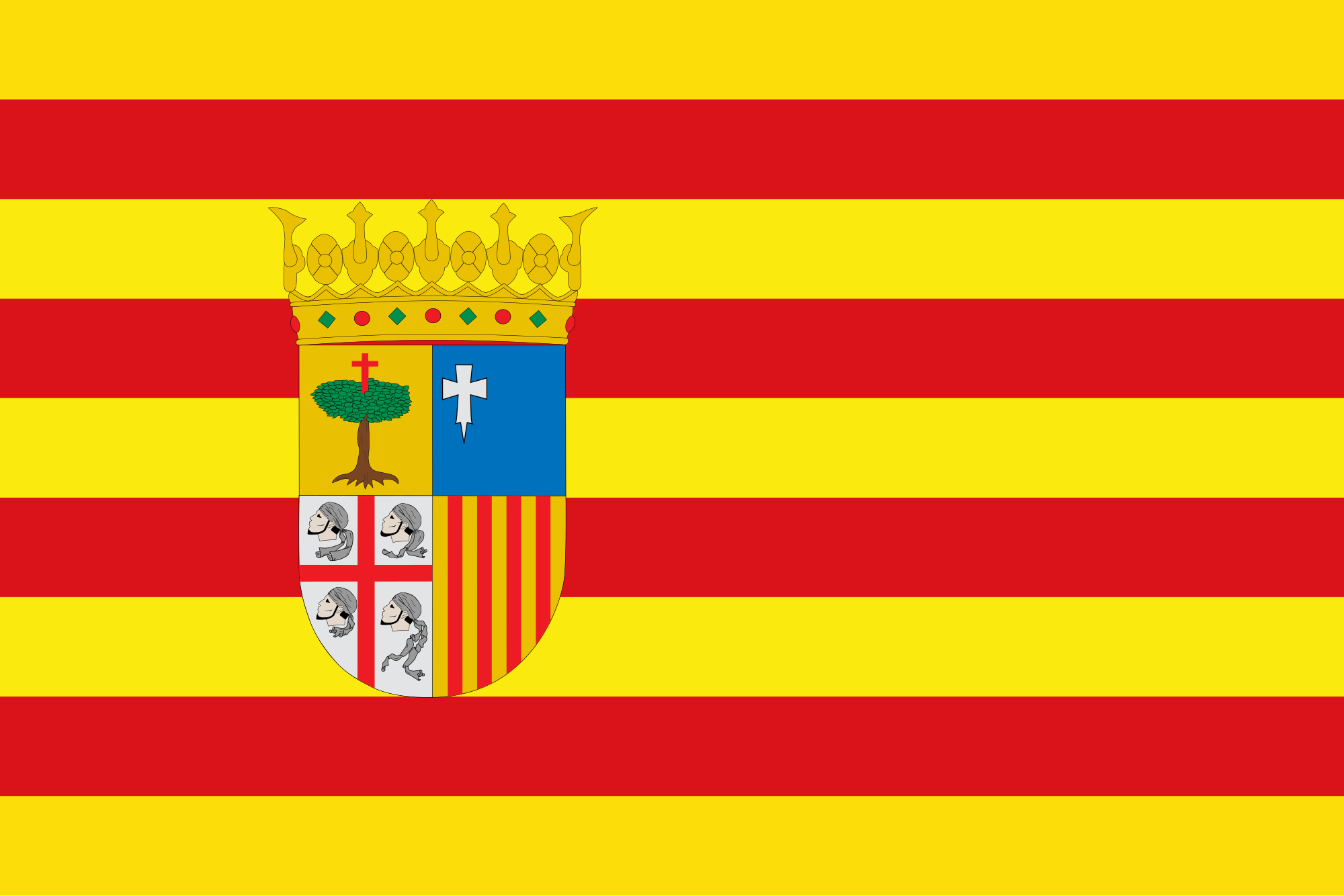 Aragón
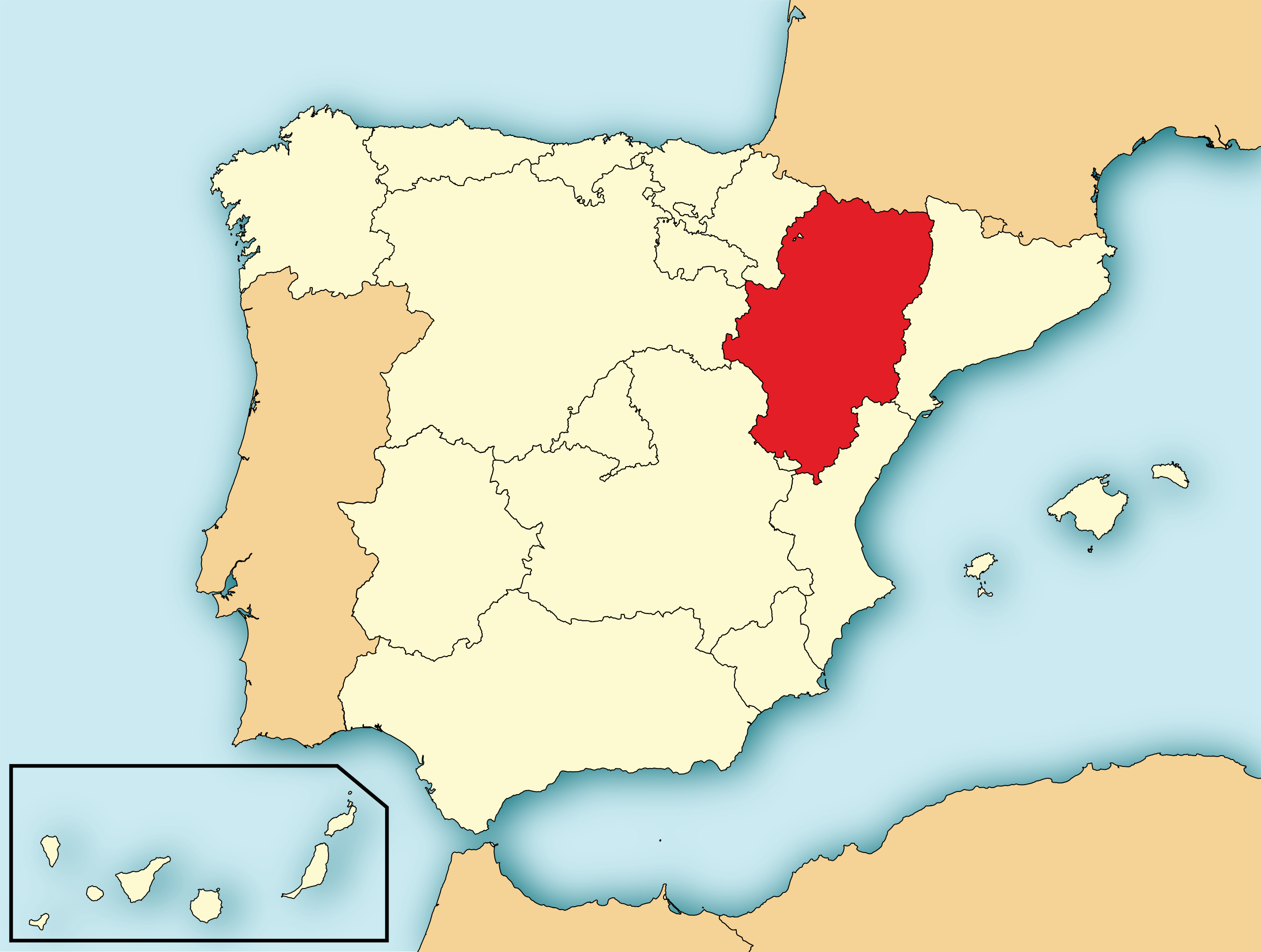
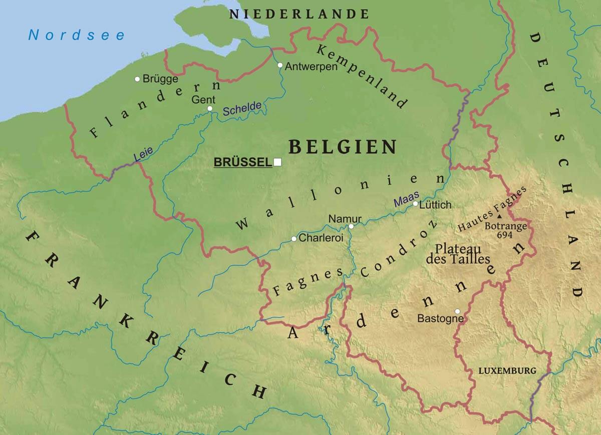
Aragonien oder Aragon (spanisch und aragonesisch Aragón, katalanisch Aragó) ist eine autonome Gemeinschaft im Nordosten Spaniens. Sie grenzt im Norden auf dem Hauptkamm der Pyrenäen an Frankreich, im Osten an Katalonien, im Südosten an Valencia und im Westen an Kastilien-La Mancha, Kastilien und León, La Rioja sowie Navarra. Hauptstadt ist Saragossa.
Das Gebiet der heutigen autonomen Gemeinschaft entspricht dem früheren Königreich Aragonien im engeren Sinne, das seinen Namen wiederum dem Fluss Aragón verdankte.
阿拉贡(西班牙语:Aragón;加泰罗尼亚语:Aragó;阿拉贡语:Aragón)是西班牙东北部的一个自治区,面积47,719平方公里,人口1,277,471(2003年)。
阿拉贡向北与法国相邻,向东是加泰罗尼亚,向南是巴伦西亚省,向西是卡斯蒂利亚-拉曼恰、卡斯蒂利亚-莱昂、拉里奥哈和纳瓦拉。萨拉戈萨省、韦斯卡省和特鲁埃尔省属于阿拉贡自治地区。阿拉贡的首府是萨拉戈萨。

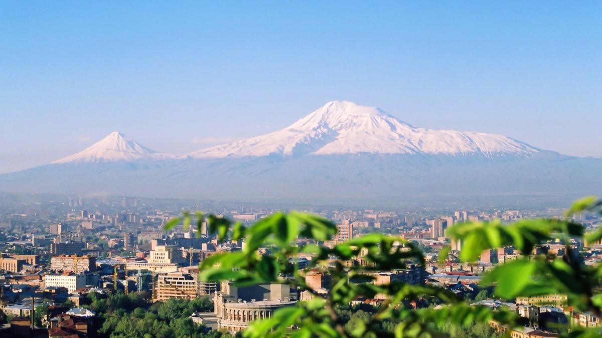
阿勒山(土耳其语:Ağrı Dağı;亚美尼亚语:Արարատ),坐落在土耳其厄德尔省的东北边界附近,为土耳其的最高峰,距伊朗国界仅16公里,而距亚美尼亚国界也仅32公里,甚至可眺望亚美尼亚的首都埃里温,其因基督教的圣经《创世记》一篇中记载,著名的诺亚方舟在大洪水后,最后停泊的地方就在阿勒山上,因此也使得阿勒山在亚伯拉罕宗教远近驰名。
Der Berg Ararat, auch Großer Ararat (türkisch Büyük Ağrı Dağı, aus dem Hebräischen, entstanden aus assyrisch Urartu; armenisch Մասիս Masis oder Արարատ Ararat, kurdisch Çiyayê Agirî / Shaxi, auch traditionell persisch كوه نوح, DMG Kūh-e Nūḥ, ‚Berg Noahs‘), ist ein ruhender Vulkan im Ararathochland in Ostanatolien nahe der Grenze zu Armenien, dem Iran und der aserbaidschanischen Exklave Nachitschewan. Er ist mit 5137 m[1] über dem Meeresspiegel der höchste Berg auf dem Gebiet der Türkei. Der kurdische Name, Çiyayê Agirî, bedeutet ‚der feurige Berg‘ (agir ‚Feuer‘, çiya ‚Berg‘).
Der kleinere Nachbarberg, der Kleine Ararat (türkisch Küçük Ağrı Dağı, armenisch Սիս Sis), ist 3896 m hoch.[1] Im Jahre 2004 wurden beide Araratberge Teil eines Nationalparks.
アララト山(アララトさん)は、トルコ共和国の東端にある標高5,137mの山であり成層火山である。アルメニア語表記はԱրարատ、ペルシア語表記はآرارات、クルド語表記はÇiyayê Araratで、トルコ語ではアール山(Ağrı Dağı)と呼ぶ。主峰の東南にあたる標高3,896mの頂上を小アララト山(Küçük Ağrı Dağı)と呼んでおり、それに対して標高5,137mの主峰は公式には大アララト山(Büyük Ağrı Dağı)という。アルメニアとの国境から32km、イランとの国境から16kmである。
Mount Ararat (/ˈærəˌræt/ ARR-ə-rat;[4] Turkish: Ağrı Dağı; Armenian: Մասիս, Masis and Արարատ, Ararat) is a snow-capped and dormant compound volcano in the extreme east of Turkey. It consists of two major volcanic cones: Greater Ararat and Little Ararat. Greater Ararat is the highest peak in Turkey and the Armenian plateau with an elevation of 5,137 m (16,854 ft); while, Little Ararat's elevation is 3,896 m (12,782 ft).[5] The Ararat massif is about 35 km (22 mi) wide at ground base.[6] The first efforts to reach Ararat's summit were made in the Middle Ages. However, it was not until 1829 when Friedrich Parrot and Khachatur Abovian, accompanied by four others, made the first recorded ascent.
Despite the scholarly consensus that the "mountains of Ararat" of the Book of Genesis do not refer specifically to Mt. Ararat, it has been widely accepted in Christianity as the resting place of Noah's Ark. It is the principal national symbol of Armenia and has been considered a sacred mountain by Armenians. It is featured prominently in Armenian literature and art and is an icon for Armenian irredentism. Along with Noah's Ark, it is depicted on the coat of arms of Armenia.
Le mont Ararat, en turc Ağrı Dağı ; en arménien Արարատ ; en kurde Çiyayê Agirî), appelé Masis par les Arméniens (Մասիս), les Hellènes (Μασίς) et les Hébreux (מעזיז), est le sommet le plus élevé (5 165 mètres d'altitude) de Turquie (auparavant d'Arménie occidentale). Ce volcan au sommet recouvert de neiges éternelles se situe sur le haut-plateau arménien, à l'est du pays. Les sommets du Grand Ararat et du Petit Ararat s'élèvent dans la province d'Ağrı mais 35 % du volcan appartient à la province d'Iğdır.
Il monte Ararat (Ağrı Dağı in turco, Արարատ in armeno: Agirî in curdo, آرارات in persiano) è il più alto monte della Turchia (5.137 m s.l.m.), si trova nella Turchia orientale sul confine tra la regione dell'Agri e dell'Iğdır, a 22.5 km a nord di Dogubeyazit (o Dogubayazit) (39°40'60.00"N 44°17'60.00"E), nel territorio che storicamente aveva fatto parte dell'Armenia; infatti nella lingua armena Ararat significa "Creazione di Dio" o "Luogo creato da Dio". In lingua turca invece il suo nome significa "Montagna del dolore"; la provincia stessa in cui si trova, Ağrı, significa "dolore".
El monte Ararat (en armenio, Արարատ; en turco, Ağrı Dağı) es el pico más alto de Turquía, con 5165 msnm, localizado en la parte oriental del país, muy cerca de la frontera con Irán y Armenia. Se trata de un volcán inactivo cuya cima se encuentra cubierta de nieves perpetuas.
A pesar del consenso académico de que las "montañas de Ararat" del Libro del Génesis no se refieren específicamente a este monte, el Monte Ararat ha sido sin embargo ampliamente aceptado en el cristianismo, en el judaísmo y en el islam como el lugar de descanso del Arca de Noé.
Арара́т (тур. Ağrı Dağı, арм. Արարատ и арм. Մասիս (Масис), курд. Çiyayê Agirî) — гора: самый высокий вулканический массив Армянского нагорья на востоке Турции; относится к стратовулканам. Расположен в турецком иле Ыгдыр по правому берегу среднего течения реки Аракс, в 16 километрах от границы с Ираном, в 28,5 километрах от границы с Арменией[2]. Состоит из двух слившихся основаниями конусов спящих вулканов: Большого Арарата и Малого Арарата. Вершина Большого Арарата (5165 метров над уровнем моря[3][4]) является самой высокой точкой Турции.

Der Aras, Araks oder Arax, aserbaidschanisch Araz, persisch ارس (rud-e) Aras, armenisch Արաքս Araks, kurdisch Erez, urartäisch Muna,[2] griechisch Araxes, türkisch Aras Nehri) ist mit 1072 km Länge der längste Nebenfluss der Kura in Vorderasien. Er wird von den Brücken von Choda Afarin gequert.
阿拉斯河[1](土耳其语:Aras Nehri,亚美尼亚语:Արաքս,罗马化:Araks,阿塞拜疆语:ارس,آراز,波斯语:ارس),亚美尼亚称之为阿拉克斯河[2][3],是欧亚大陆高加索地区的河流,流经土耳其、亚美尼亚、阿塞拜疆和伊朗,河道全长1,072公里,流域面积102,000平方公里,为库拉河的最大支流。

 Animal world
 Utah-UT
 Grand Est
 North Rhine-Westphalia
 Rhineland-Palatinate
 Argentina
 Party and government
 Group of the twenty most important industrial and emerging countries
Party and government
BRICS
Group of the twenty most important industrial and emerging countries
Party and government
BRICS


Der Argun bzw. Ergun (burjatisch für „breiter Fluss“; russisch Аргунь/Argun; chinesisch 額爾古納河 / 额尔古纳河, Pinyin E'erguna He) ist der etwa 1620 km lange rechte, d. h. südliche Quellfluss des Amur (Heilong Jiang) in Nordost-China (Asien).
额尔古纳河[a](蒙古语:ᠡᠷᠬᠥᠨᠠ
ᠭᠣᠣᠯ,西里尔字母:Эргүнэ гол;布里亚特语:Үргэнэ гол,罗马化:Ürgene gol),清代也作额尔古讷河(满语:ᡝᡵᡤᡠᠨᡝ
ᠪᡳᡵᠠ,穆麟德转写:ergune bira),俄罗斯称阿尔贡河(俄语:река́ Аргу́нь,罗马化:reká Argúnʹ),是位于中国内蒙古自治区呼伦贝尔盟和俄罗斯联邦外贝加尔边疆区之间的一条河流,自南偏西流向北偏东,蜿蜒在呼伦贝尔草原上。额尔古纳河和俄罗斯境内的石勒喀河交汇后形成黑龙江。