
Deutsch-Chinesische Enzyklopädie, 德汉百科
 Gansu Sheng-GS

Der Autonome Bezirk Linxia der Hui (chinesisch 临夏回族自治州, Pinyin Línxià Huízú Zìzhìzhōu) ist ein Bezirk der chinesischen Provinz Gansu. Auf 8.117 km² leben 2.058.800 Menschen (Stand: Ende 2018)[1]. Die Hauptstadt Linxia ist eine wichtige Stadt an der alten Seidenstraße und der Tangfan-Straße.
临夏回族自治州,简称临夏州,古称枹罕、河州,是中华人民共和国甘肃省下辖的自治州,位于甘肃省中部,黄河上游。州境北临兰州市,东界定西市,南邻甘南州,西毗青海省海东市。地处黄土高原与青藏高原交界,地貌多为山地丘陵,地势自西南向东北递降。黄河、洮河、大夏河、广通河等流贯境内。全州总面积7,331平方公里,人口201.21万,汉族人口比例约40%,回族人口比例约32%,州人民政府驻临夏市。首府临夏市是古代丝绸之路、唐蕃古道的重镇,明代四大茶马司之一,有“河湟雄镇”之称。临夏州下辖1个县级市、5个县、2个自治县。 县级市:临夏市(州府) 县:临夏县、康乐县、永靖县、广河县、和政县 自治县:东乡族自治县、积石山保安族东乡族撒拉族自治县
Anhui Sheng-AH
Beijing Shi-BJ
China
Chongqing Shi-CQ
Fujian Sheng-FJ
Gansu Sheng-GS
Gansu Sheng-GS
Guangxi Zhuangzu Zizhiqu-GX
Guizhou Sheng-GZ
Hainan Sheng-HI
Hebei Sheng-HE
Heilongjiang Sheng-HL
Henan Sheng-HA
Hongkong Tebiexingzhengqu-HK
Hubei Sheng-HB
Hunan Sheng-HN
Jiangsu Sheng-JS
Jiangxi Sheng-JX
Jilin Sheng-JL
Liaoning Sheng-LN
Nei Mongol Zizhiqu-NM
Ningxia Huizu Zizhiqu-NX
Qinghai Sheng-QH
Shaanxi Sheng-SN
Shandong Sheng-SD
Shanghai Shi-SH
Shanxi Sheng-SX
Sichuan Sheng-SC
Tianjin Shi-TJ
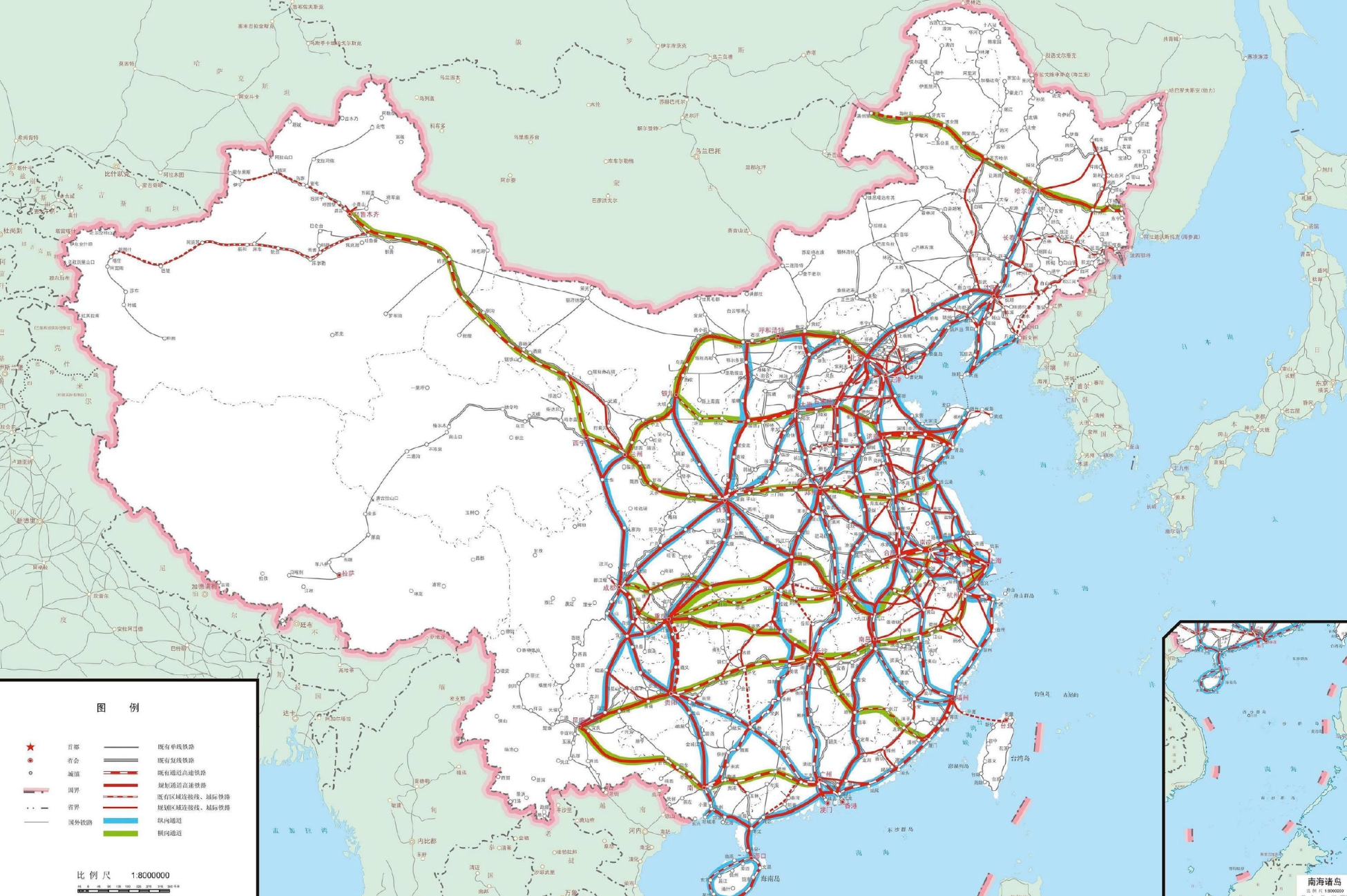
 Transport and traffic
 Railway
Xinjiang Uygur Zizhiqu-XJ
Yunnan Sheng-YN
Zhejiang Sheng-ZJ
Railway
Xinjiang Uygur Zizhiqu-XJ
Yunnan Sheng-YN
Zhejiang Sheng-ZJ

 Geography

Altun, auch Altun Shan, Altyntag, Altin tagh bzw. Astin tagh (chinesisch 阿爾金山 / 阿尔金山, Pinyin Ā'ěrjīn Shān) genannt, ist ein bis zu 6295 m hohes Hochgebirge im Westen der Volksrepublik China beziehungsweise in Hochasien.
阿尔金山脉(Altyn-Tagh),蒙古语意为“有柏树的山”。[1]山脉位于青藏高原北面,是构成青藏高原北边屏障的山脉之一,也是柴达木盆地与塔里木盆地的界山。位置介于北纬37°~39°30′之间,东经86°~94°10'之间,大致呈东西走向,东面与祁连山衔接,西端昆仑山分界,全长720公里,最宽处超过100公里,面积6.2万平方公里。
阿尔金山脉西高东低,一般海拔3500至4000米,最高峰为苏拉木塔格峰,海拔6295米,位于新疆南部苏拉木塔格山的主脊。阿尔金山山体两翼不对称,北坡相对高度可达2500米以上,南坡地势缓和,高差小。
山脉的气候十分干燥。3000米中山带年降水量在100毫米以下,山坡上干燥剥蚀强烈,形成黄土状物质堆积;3500米的亚高山带年降水量稍增,但仍然干旱;4000米的高山带干旱寒冷,寒冻风化强烈;5500米以上的山峰终年积雪和有现代冰川发育。

Amdo ist eine nordosttibetische Region, die sich über die heutigen chinesischen Provinzen Qinghai, Gansu und Sichuan erstreckt. Sie wird zusammen mit Kham und Dbus-Gtsang als eine der drei historischen Provinzen Tibets bezeichnet, war jedoch nie eine administrative Einheit. Bis ins 19. Jahrhundert taucht der Begriff nicht einzeln auf, sondern in Kombination mit Kham als Dokham (mdo khams) und bezeichnet Osttibet.
安多(藏语:ཨ༌མདོ།,威利转写:a mdo,藏语拼音:Amdo),源自藏族传统文化,是藏地的区划之一,常与卫藏和康区并列。安多位于青藏高原,其范围大致相当于今中华人民共和国青海省的海北、海南、黄南、果洛、海西五个藏族自治州,甘肃省的甘南藏族自治州和四川省的阿坝藏族羌族自治州北部。
Fujian Sheng-FJ
Gansu Sheng-GS
Hubei Sheng-HB
Jiangxi Sheng-JX
Ningxia Huizu Zizhiqu-NX
Shaanxi Sheng-SN


Anhui Sheng-AH
China
Gansu Sheng-GS
Henan Sheng-HA
Jiangsu Sheng-JS
Shaanxi Sheng-SN
Xinjiang Uygur Zizhiqu-XJ

 Beijing Shi-BJ
China
Gansu Sheng-GS
Hebei Sheng-HE
Nei Mongol Zizhiqu-NM
Ningxia Huizu Zizhiqu-NX
Qinghai Sheng-QH
Xizang Zizhiqu-XZ
Beijing Shi-BJ
China
Gansu Sheng-GS
Hebei Sheng-HE
Nei Mongol Zizhiqu-NM
Ningxia Huizu Zizhiqu-NX
Qinghai Sheng-QH
Xizang Zizhiqu-XZ

 Gansu Sheng-GS
Hebei Sheng-HE
Ningxia Huizu Zizhiqu-NX
Shaanxi Sheng-SN
Shandong Sheng-SD
Shanxi Sheng-SX
Gansu Sheng-GS
Hebei Sheng-HE
Ningxia Huizu Zizhiqu-NX
Shaanxi Sheng-SN
Shandong Sheng-SD
Shanxi Sheng-SX
 Chongqing Shi-CQ
Gansu Sheng-GS
Guangxi Zhuangzu Zizhiqu-GX
Guizhou Sheng-GZ
Ningxia Huizu Zizhiqu-NX
Shaanxi Sheng-SN
Sichuan Sheng-SC
Chongqing Shi-CQ
Gansu Sheng-GS
Guangxi Zhuangzu Zizhiqu-GX
Guizhou Sheng-GZ
Ningxia Huizu Zizhiqu-NX
Shaanxi Sheng-SN
Sichuan Sheng-SC

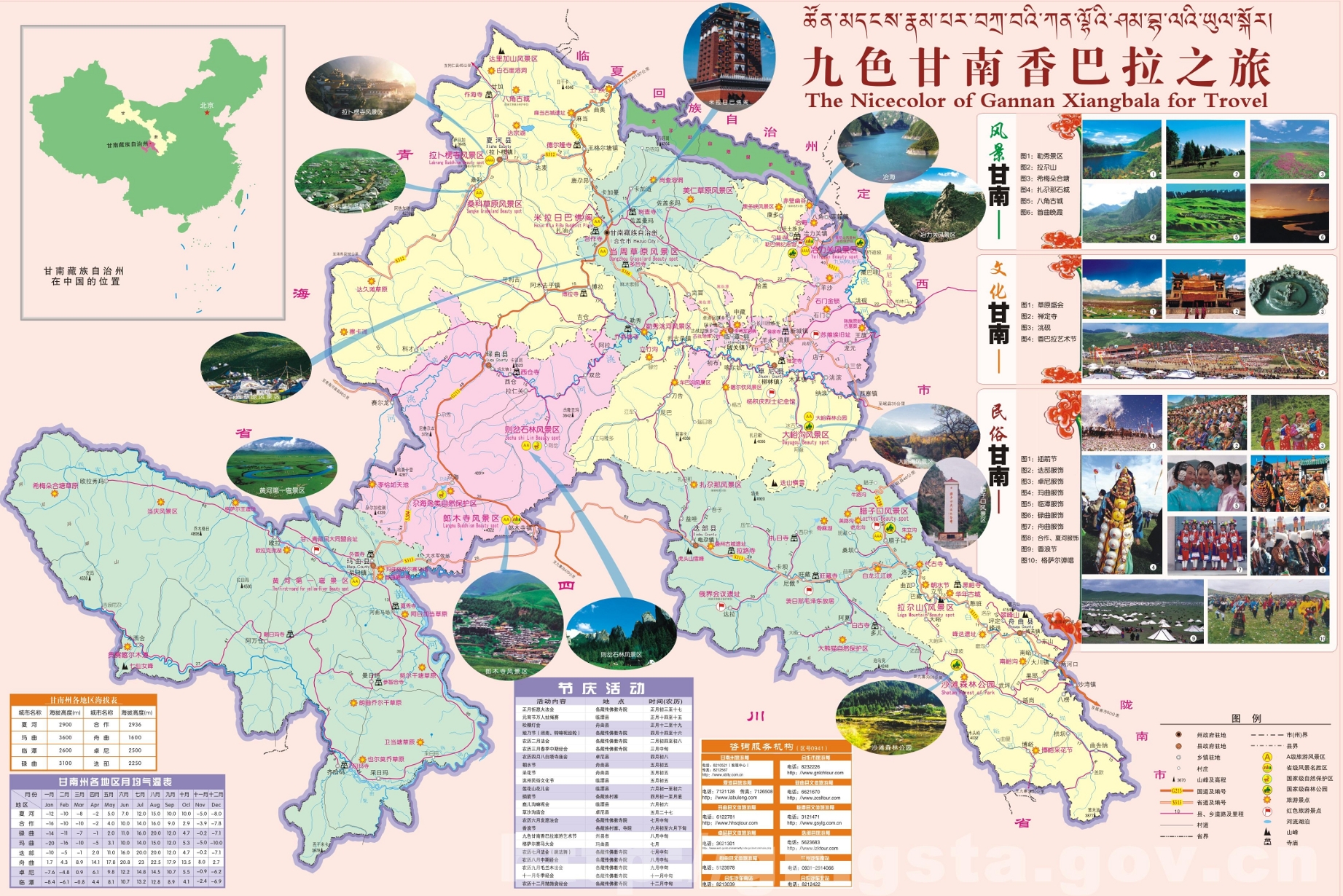
Der Autonome Bezirk Gannan der Tibeter liegt im Südosten der chinesischen Provinz Gansu und wird der tibetischen Kulturregion Amdo zugerechnet. Seine Hauptstadt ist Hezuo (合作市), tib. Heitso (34° 59′ N, 102° 30′ OKoordinaten: 34° 59′ N, 102° 30′ O). Gannan hat eine Fläche von 40.201 km² und ca. 680.000 Einwohner (Ende 2004).
Berühmtestes Kloster des Bezirks ist das Gelugpa-Großkloster Labrang.