
漢德百科全書 | 汉德百科全书
 Slovenia
 Sport
Sport


 Hand in Hand
Albania
Aleksandar Vučić
Alexander De Croo
Alexander Stubb
Andorra
Andrej Plenković
Armenia
Azerbaijan
Belgium
Bjarni Benediktsson
Bosnia Herzegovina
Bulgaria
Charles Michel
Denmark
Denis Bećirović
Germany
Dick Schoof
Donald Tusk
Edi Rama
Emmanuel Macron
England
Estonia
Hand in Hand
Albania
Aleksandar Vučić
Alexander De Croo
Alexander Stubb
Andorra
Andrej Plenković
Armenia
Azerbaijan
Belgium
Bjarni Benediktsson
Bosnia Herzegovina
Bulgaria
Charles Michel
Denmark
Denis Bećirović
Germany
Dick Schoof
Donald Tusk
Edi Rama
Emmanuel Macron
England
Estonia
 European Union
Evika Siliņa
Finland
France
Georgia
Giorgia Meloni
Gitanas Nausėda
Greece
Hristijan Mickoski
Ilham Aliyev
Ireland
Iceland
Italy
Jakov Milatović
Jens Stoltenberg
Jonas Gahr Støre
Kaja Kallas
Keir Starmer
Klaus Johannis
Kosovo
Croatia
Kyriakos Mitsotakis
Latvia
Liechtenstein
Lithuania
Luc Frieden
Luxembourg
Maia Sandu
Malta
Mette Frederiksen
Moldawien
Monaco
Montenegro
Netherlands
Nikol Pashinyan
Nordmazedonien
Norwegen
Olaf Scholz
Austria
European Union
Evika Siliņa
Finland
France
Georgia
Giorgia Meloni
Gitanas Nausėda
Greece
Hristijan Mickoski
Ilham Aliyev
Ireland
Iceland
Italy
Jakov Milatović
Jens Stoltenberg
Jonas Gahr Støre
Kaja Kallas
Keir Starmer
Klaus Johannis
Kosovo
Croatia
Kyriakos Mitsotakis
Latvia
Liechtenstein
Lithuania
Luc Frieden
Luxembourg
Maia Sandu
Malta
Mette Frederiksen
Moldawien
Monaco
Montenegro
Netherlands
Nikol Pashinyan
Nordmazedonien
Norwegen
Olaf Scholz
Austria
 Party and government
Party and government
Party and government
 European Political Community Summit
Pedro Sánchez
Petr Fiala
Poland
Portugal
Robert Abela
Robert Golob
Romania
Rumen Radew
San Marino
Sweden
Switzerland
Serbia
Simon Harris
Slovakia
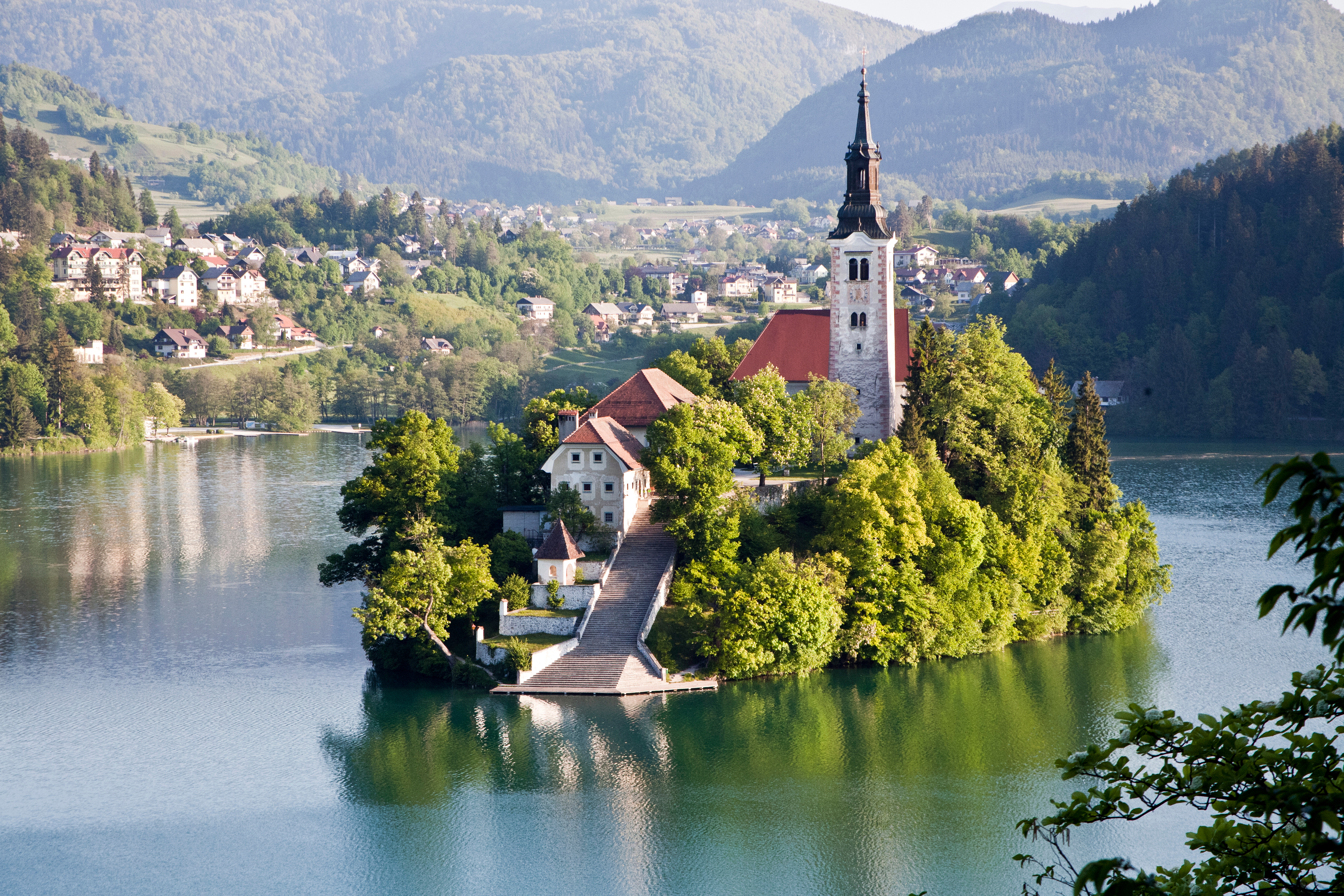
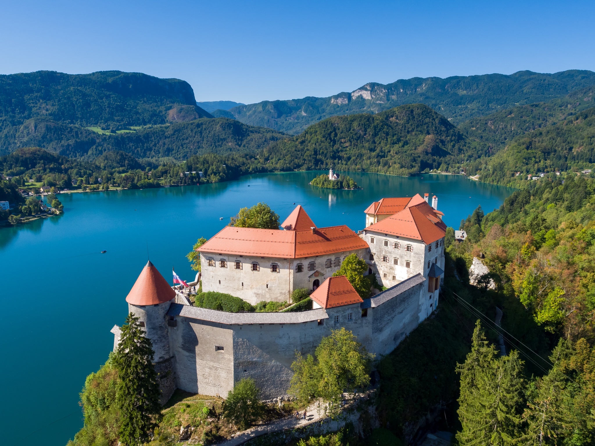
Slovenia
Spain
Czech Republic
Turkey
Ukraine
Hungary
United Kingdom
Viktor Orbán
Viola Amherd
Wolodymyr Selenskyj
Cyprus
European Political Community Summit
Pedro Sánchez
Petr Fiala
Poland
Portugal
Robert Abela
Robert Golob
Romania
Rumen Radew
San Marino
Sweden
Switzerland
Serbia
Simon Harris
Slovakia
Slovenia
Spain
Czech Republic
Turkey
Ukraine
Hungary
United Kingdom
Viktor Orbán
Viola Amherd
Wolodymyr Selenskyj
Cyprus


 Architecture

 Geography
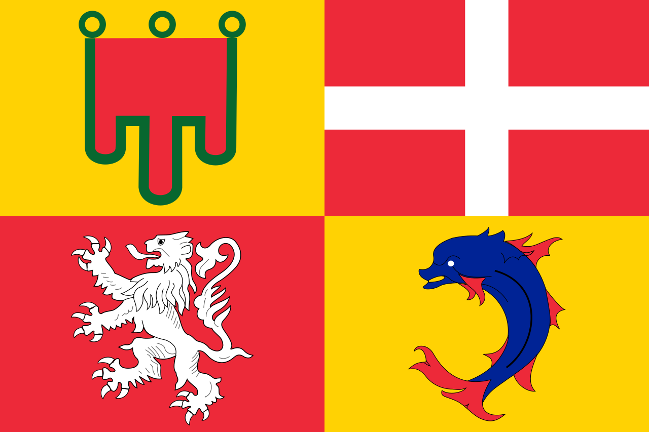 Auvergne-Rhône-Alpes
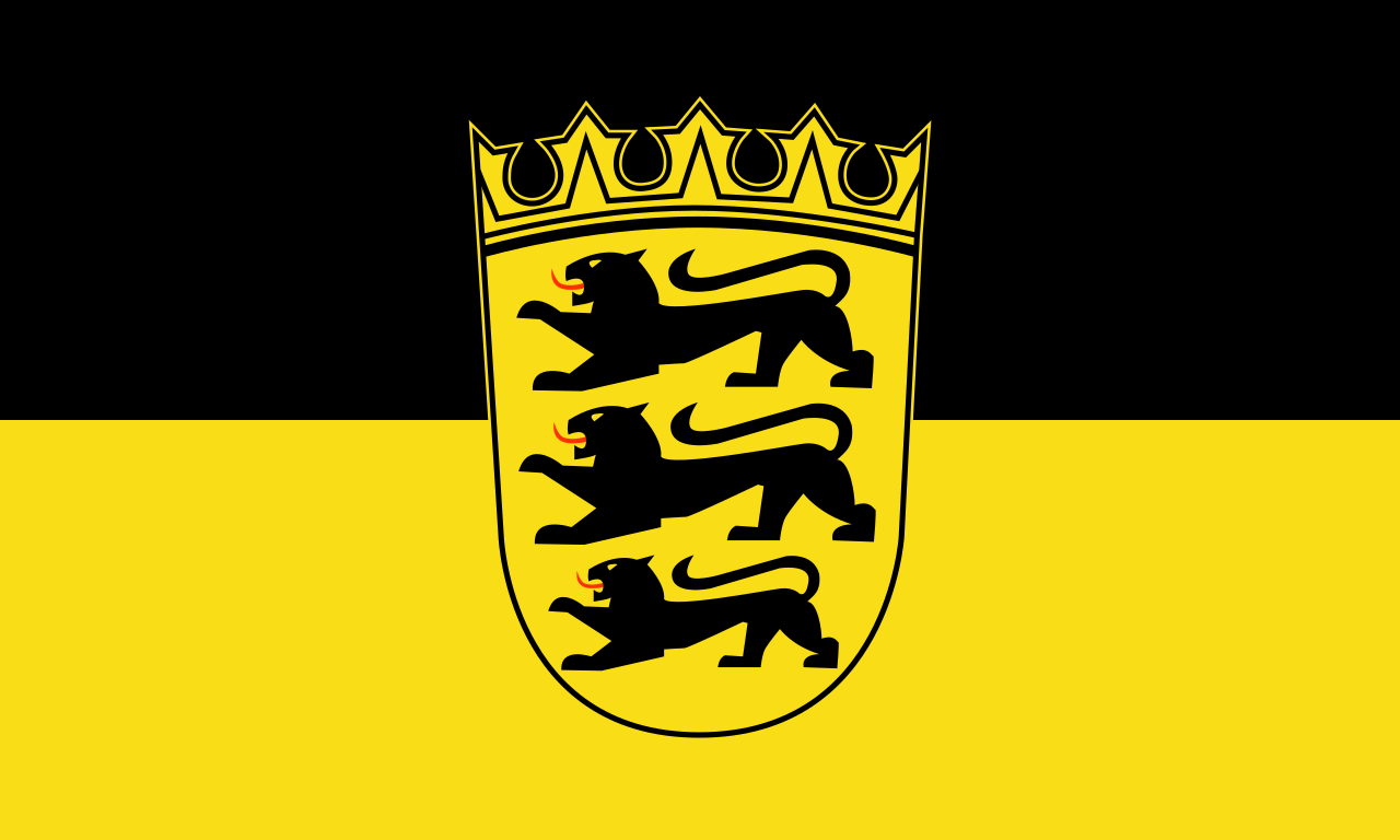 Baden-Wuerttemberg
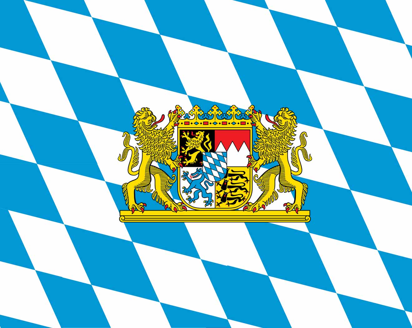 Bavaria
Germany
France
Bavaria
Germany
France
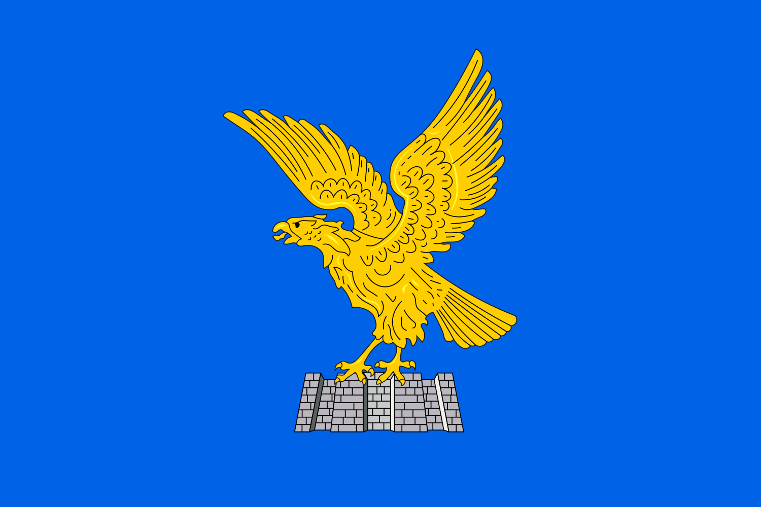 Friuli-Venezia Giulia
Italy
Liechtenstein
Friuli-Venezia Giulia
Italy
Liechtenstein
 Lombardia
Monaco
Austria
Lombardia
Monaco
Austria
 Piemonte
 Provence-Alpes-Côte d´Azur
Switzerland
Slovenia
Provence-Alpes-Côte d´Azur
Switzerland
Slovenia
 Tyrol
Tyrol
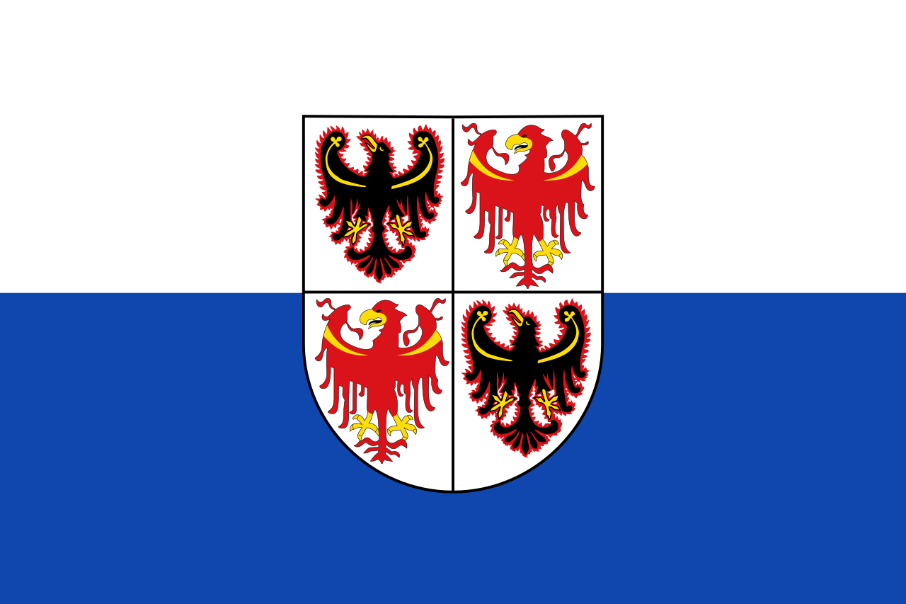 Trentino-Alto Adige
 Valle d´Aosta
 Veneto
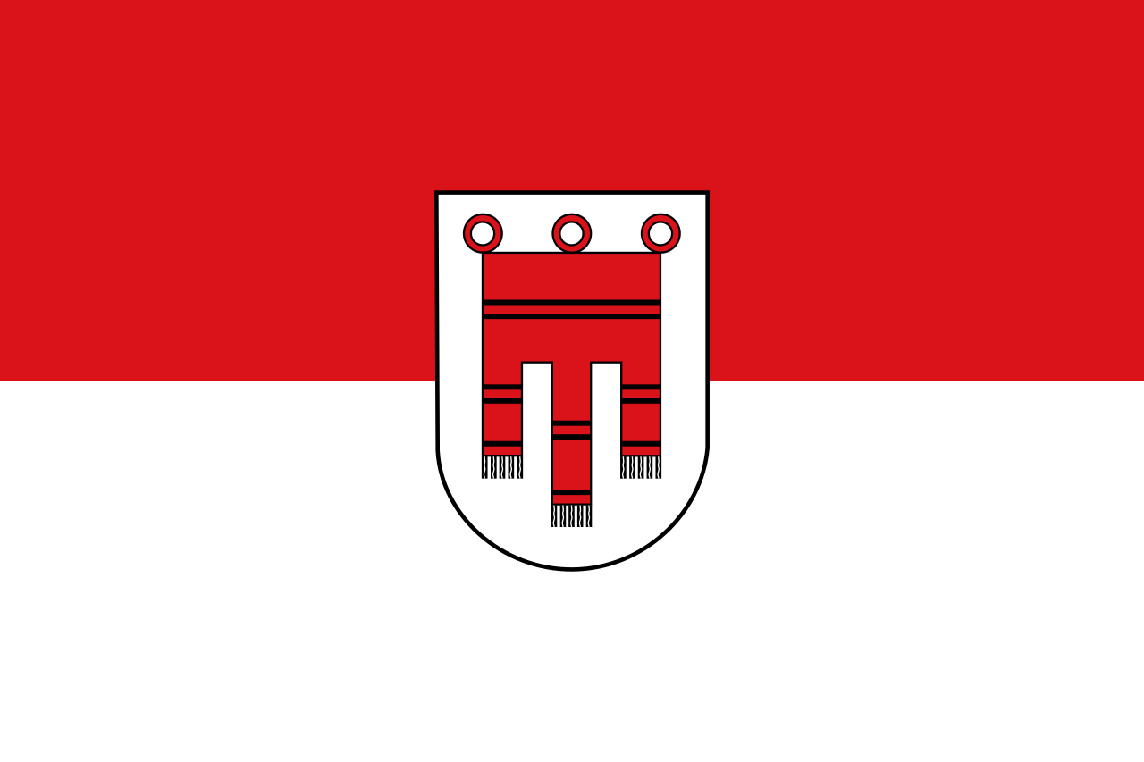 Vorarlberg
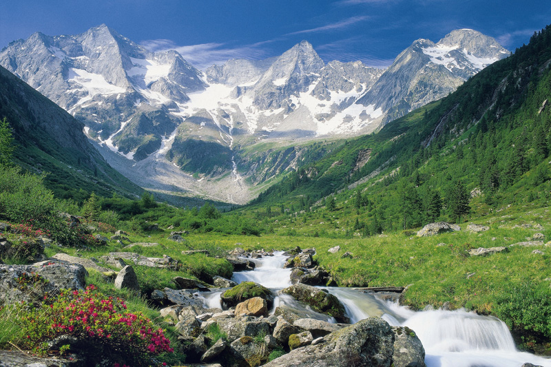
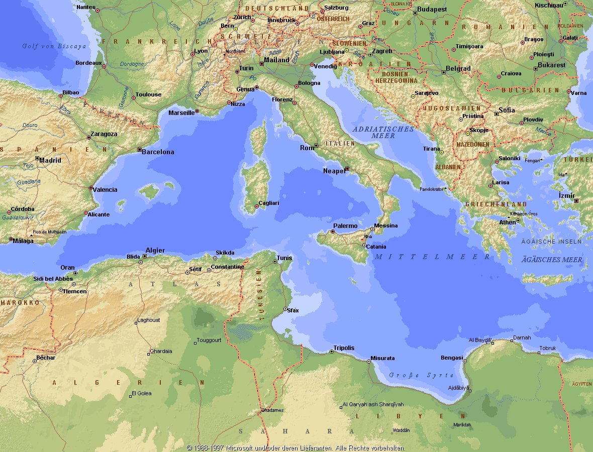
Die Alpen sind das höchste Gebirge im Inneren Europas. Es erstreckt sich in einem 1200 Kilometer langen und zwischen 150 und 250 Kilometer[1] breiten Bogen vom Ligurischen Meer bis zum Pannonischen Becken.
Die gesamte Alpenregion nimmt eine Fläche von etwa 200.000 Quadratkilometern ein.[2] Sie dehnt sich etwa 750 km von West nach Ost und ca. 400 km von Süd nach Nord aus und wird vom Rhonetal, dem Schweizer Mittelland, dem Oberlauf der Donau, der Kleinen Ungarischen Tiefebene, der Po-Ebene und dem Golf von Genua umgrenzt.
Der Alpenbogen schließt im Südwesten am Golf von Genua an den Apennin an, umfasst die Po-Ebene, verzweigt sich zum Französischen und Schweizer Jura und endet fächerförmig im Osten vor dem westpannonischen Berg- und Hügelland. Im Nordosten an der Donau bei Wien sind die Alpen durch das Wiener Becken von den geologisch verwandten Karpaten getrennt, im Südosten gehen sie in das stark verkarstete Dinarische Gebirge über. Im Norden fallen die Alpen allmählich zum österreichischen und deutschen Alpenvorland ab. Im Süden ist der Abfall zur Po-Ebene steiler. Der Gebirgszug, zu dem die Alpen gehören, erstreckt sich vom afrikanischen Atlas bis nach Südostasien.[3]
Die Gipfelhöhen in den westlichen Gebirgsstöcken liegen meist zwischen 3000 und 4300 Meter über dem Meeresspiegel, in den Ostalpen sind die Berge etwas niedriger. Der höchste Gipfel der Alpen ist der Mont Blanc mit 4810 Metern. 128 Berge der Alpen sind Viertausender, etliche Berge mehr oder weniger vergletschert. Die Alpen sind in zahlreiche Gebirgsgruppen und -ketten gegliedert.
Die Alpen bilden im „Herzen Europas“[4] eine wichtige Klima- und Wasserscheide. Sie trennen den zentralen Mittelmeerraum mit dem Etesienklima vom atlantisch beeinflussten nördlichen Mitteleuropa und stehen am Ostrand unter kontinentalem Einfluss. Auch die Entwässerung folgt diesen Großrichtungen zu Mittelmeer, Nordsee und Schwarzem Meer.
Der Alpenraum umfasst Gebiete der acht Alpenstaaten Frankreich, Monaco, Italien, Schweiz, Liechtenstein, Deutschland, Österreich und Slowenien. Er bildet den Lebensraum von 13 Millionen Menschen und genießt europäische Bedeutung als Erholungsraum.[4] Ungarn hat Anteile an Mittelgebirgen, die zu den Alpen gezählt werden, beispielsweise an Günser und Ödenburger Gebirge, wird in der Regel jedoch nicht zum Alpenraum gezählt. Seit der Frühgeschichte stellen Alpentäler und -pässe auch wichtige transeuropäische Verkehrsverbindungen dar.
欧洲南部高大的山脉。西起法国尼斯附近地中海海岸,呈弧形向北、东延伸,经意大利北部、瑞士南部、列支敦士登、德国西南部,东止奥地利的维也纳盆 地。总面积约22万平方千米。长约1200千米,宽130~260千米,东宽西窄。平均海拔3000米左右。 山脉主干向西南方向延伸为比利牛斯山脉,向南延伸为亚平宁山脉,向东南方向延伸为迪纳拉山脉,向东延伸为喀尔巴阡山脉。阿尔卑斯山脉可分为3段。西段西阿 尔卑斯山从地中海岸,经法国东南部和意大利的西北部,到瑞士边境的大圣伯纳德山口附近,为山系最窄部分,也是高峰最集中的山段。勃朗峰(4810米)是整 个山脉的最高点,位于法国和意大利边界。中段中阿尔卑斯山,介于大圣伯纳德山口和博登湖之间,宽度最大。有马特峰(4479米)和蒙特罗莎峰( 4634米)。东段东阿尔卑斯山在博登湖以东,海拔低于西、中两段阿尔卑斯山。
阿尔卑斯山(德语:Alpen;法语:Alpes;意大利语:Alpi;斯洛文尼亚语:Alpe)是一座位于欧洲中心的山脉,它覆盖了意大利北部边界、法国东南部、瑞士、列支敦士登、奥地利、德国南部及斯洛文尼亚。它可以被细分为三个部分,从地中海到勃朗峰的西阿尔卑斯山,从瓦莱达奥斯塔到布伦纳山口(奥地利和意大利交界处)的中阿尔卑斯山,从布伦纳山口到斯洛文尼亚的东阿尔卑斯山。欧洲许多大河都发源于此,水力资源丰富,为旅游、度假、疗养胜地。
阿尔卑斯山共有128座海拔超过4000米的山峰,其中最高峰勃朗峰海拔4810.45米[1],位于法国和意大利的交界处。山脉呈弧形,长1200千米,宽130~260千米,平均海拔约3000米,总面积约22万平方千米[2]。阿尔卑斯山北边是水汽较多的气候,而南边则较为干燥,雨量很少。
アルプス山脈(アルプスさんみゃく、羅: Alpes アルペース、仏: Alpes、伊: Alpi、独: Alpen、英: Alps)は、アルプス・ヒマラヤ造山帯に属し、ヨーロッパ中央部を東西に横切る「山脈」である。オーストリア、スロベニアを東端とし、イタリア、ドイツ、リヒテンシュタイン、スイス各国にまたがり、フランスを南西端とする多国にまたがっている。アルプ(スイスの高山山腹の夏季放牧場;英語: alp,フランス語: alpe,ドイツ語: Alpe)がいっぱいであるからアルプスであると考える説と、ケルト語の alp「岩山」を語源とし、ラテン語を経由したと考える説がある。最高峰のモンブランは標高4,810.9m(2007年)で、フランスとイタリアの国境をなし、ヨーロッパの最高峰[1]でもある。
アルプス山脈はヨーロッパの多数の河川の水源地となっており、ここからドナウ川、ライン川、ローヌ川、ポー川、といった大河川が流れ出て、それぞれ黒海、北海、地中海、アドリア海へと注ぐ。
The Alps (/ælps/; French: Alpes [alp]; German: Alpen [ˈalpn̩]; Italian: Alpi [ˈalpi]; Romansh: Alps; Slovene: Alpe [ˈáːlpɛ]) are the highest and most extensive mountain range system that lies entirely in Europe,[2][note 1] stretching approximately 1,200 kilometres (750 mi) across eight Alpine countries (from west to east): France, Switzerland, Italy, Monaco, Liechtenstein, Austria, Germany, and Slovenia.[3] The mountains were formed over tens of millions of years as the African and Eurasian tectonic plates collided. Extreme shortening caused by the event resulted in marine sedimentary rocks rising by thrusting and folding into high mountain peaks such as Mont Blanc and the Matterhorn. Mont Blanc spans the French–Italian border, and at 4,810 m (15,781 ft) is the highest mountain in the Alps. The Alpine region area contains about a hundred peaks higher than 4,000 metres (13,000 ft).
The altitude and size of the range affects the climate in Europe; in the mountains precipitation levels vary greatly and climatic conditions consist of distinct zones. Wildlife such as ibex live in the higher peaks to elevations of 3,400 m (11,155 ft), and plants such as Edelweiss grow in rocky areas in lower elevations as well as in higher elevations. Evidence of human habitation in the Alps goes back to the Palaeolithic era. A mummified man, determined to be 5,000 years old, was discovered on a glacier at the Austrian–Italian border in 1991.
By the 6th century BC, the Celtic La Tène culture was well established. Hannibal famously crossed the Alps with a herd of elephants, and the Romans had settlements in the region. In 1800, Napoleon crossed one of the mountain passes with an army of 40,000. The 18th and 19th centuries saw an influx of naturalists, writers, and artists, in particular, the Romantics, followed by the golden age of alpinism as mountaineers began to ascend the peaks.
The Alpine region has a strong cultural identity. The traditional culture of farming, cheesemaking, and woodworking still exists in Alpine villages, although the tourist industry began to grow early in the 20th century and expanded greatly after World War II to become the dominant industry by the end of the century. The Winter Olympic Games have been hosted in the Swiss, French, Italian, Austrian and German Alps. At present, the region is home to 14 million people and has 120 million annual visitors.[4]
Les Alpes (prononcé [alp]) sont une chaîne de montagnes qui s'étend en Europe, recouvrant la frontière nord de l'Italie, le Sud-Est de la France, Monaco, la Suisse, le Liechtenstein, l'Autriche, le Sud de l'Allemagne et la Slovénie.
Les Alpes culminent à 4 809 mètres, au sommet du mont Blanc. On recense 82 sommets majeurs de plus de 4 000 m d'altitude (Suisse : 48, Italie : 38, France : 24). Les cols de montagne reliant les vallées ou les pays dépassent souvent les 2 000 m d'altitude. Les Alpes forment une barrière de 1 200 km entre la Méditerranée et le Danube.
Le Alpi sono la catena montuosa più importante d'Europa, situate nell'Europa centrale a cavallo dei confini di Italia, Francia, Svizzera, Liechtenstein, Germania, Austria, Slovenia e Ungheria, separando l'Europa settentrionale da quella meridionale con lo stivale italiano. Suddivise in varie sezioni e svariati sottogruppi racchiudono in sé le vette più alte del continente centrale europeo, rivestendo anche un'importanza storica, naturalistica, idrografica e turistico-economica per i rispettivi paesi.
Los Alpes son una importante cadena de montañas situada en la Europa Central. Su cumbre más alta es el Mont Blanc, con 4.810 metros de altitud. Alrededor de los Alpes, favorecidos por ríos importantes de caudal uniforme y ricas tierras de cultivo, se ubicaron desde la prehistoria diversos pueblos, principalmente celtas, como los borgoñones, leucos, lombardos, helvecios, y posteriormente germánicos en el noreste y pueblos itálicos después de la conquista de la Galia Cisalpina por Julio César. Actualmente viven unos 14 millones de personas en la región de los Alpes.
А́льпы (фр. Alpes, нем. Alpen, итал. Alpi, романш. Alps, словен. Alpe) — самый высокий и протяжённый горный хребет среди систем, целиком лежащих в Европе. При этом Кавказские горы выше, а Уральские — протяжённей, но они лежат также и на территории Азии (в зависимости от выбранного определения границы между Европой и Азией).
Альпы представляют собой сложную систему хребтов и массивов, протянувшуюся выпуклой к северо-западу дугой от Лигурийского моря до Среднедунайской низменности. Альпы располагаются на территории 8 стран: Франции, Монако, Италии, Швейцарии, Германии, Австрии, Лихтенштейна и Словении. Общая длина альпийской дуги составляет около 1200 км (по внутреннему краю дуги — около 750 км), ширина — до 260 км. Самой высокой вершиной Альп является гора Монблан высотой 4810 метров над уровнем моря, расположенная на границе Франции и Италии[1]. Всего в Альпах сосредоточено около 100 вершин-четырёхтысячников[2].
Альпы являются международным центром альпинизма, горнолыжного спорта и туризма. Туризм в Альпах начал активно развиваться в XX веке и получил большой толчок после окончания Второй мировой войны, став одним из главных направлений в конце столетия. Пять стран из восьми (Швейцария, Франция, Италия, Австрия и Германия) были хозяйками Зимних Олимпийских игр, которые проводились в альпийских объектах[3]. Несмотря на активное развитие туризма, в альпийском регионе по-прежнему существует самобытная традиционная культура, включая сельское хозяйство, деревообработку и сыроварение.
Благодаря расположению в центре Западной Европы, Альпы являются одной из наиболее изученных горных систем. Многие понятия названы по имени Альп, в частности, альпийский климатический пояс, период альпийской складчатости, альпийский тип рельефа, альпийские луга, альпинизм.
Albania
Bosnia Herzegovina
Bulgaria
Greece
Kosovo
Croatia
Montenegro
Nordmazedonien
Romania
Serbia
Slovenia
Turkey
 Albania
Bosnia Herzegovina
Bulgaria
Greece
Kosovo
Croatia
Montenegro
Nordmazedonien
Romania
Serbia
Slovenia
Turkey
Albania
Bosnia Herzegovina
Bulgaria
Greece
Kosovo
Croatia
Montenegro
Nordmazedonien
Romania
Serbia
Slovenia
Turkey
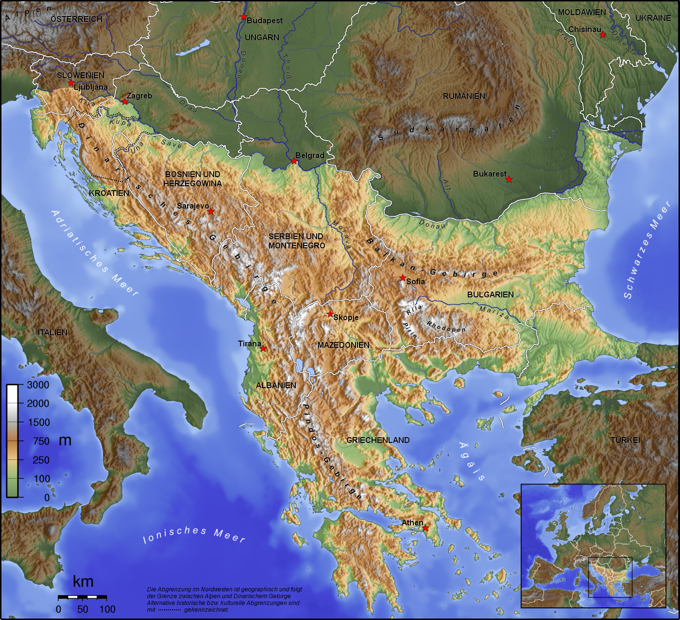
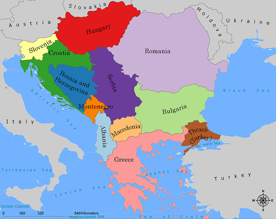
Die Balkanhalbinsel (auch kurz Balkan, oft synonym mit Südosteuropa verwendet) ist eine geographisch nicht eindeutig definierte Halbinsel im Südosten Europas. Sie ragt in das Mittelmeer und ist nach dem Balkangebirge benannt. Der größte Staat auf der Halbinsel ist Griechenland, gefolgt von Bulgarien (in dem sich der Großteil des Balkangebirges befindet), Serbien, Bosnien und Herzegowina, Albanien, Nordmazedonien, Montenegro und dem Kosovo. Die Staatsgebiete von Serbien, Kroatien, Rumänien, Slowenien und der Türkei, die durch ihre thrakischen Provinzen Anteil am Balkan hat, reichen über die Grenzen der Balkanhalbinsel hinaus.
Ungeachtet der Herleitung des geographischen Namens sind das dominierende Gebirge des Balkans die Dinariden im westlichen Teil der Halbinsel; ihr höchster Gipfel Jezerca (2694 m) liegt in Albanien. Die höchste Erhebung des Balkans ist der Gipfel Musala (2925 m) im Rila-Gebirge. Das Balkangebirge erreicht 2376 m maximale Gipfelhöhe.
巴尔干半岛(Balkans),是一个地理名词,用以描述欧洲的东南隅位于亚得里亚海和黑海之间的陆地,详细的范围依照定义不同有许多种说法。该地约有55万平方公里和近5500万人口。在古希腊时代,巴尔干半岛被称为哈伊莫司半岛。该地区的名称来自于一条通过保加利亚中心到东塞尔维亚的巴尔干山脉。[1]
巴尔干地区向来存在诸多矛盾,其中既有宗教矛盾,也有领土争端。由于半岛的地缘政治重要性,由此而来的列强干涉致使这一地区的矛盾频繁被放大为战争,因此又有欧洲火药库之称。不过近年巴尔干半岛(南斯拉夫内战后至今)已实现停火与和平,只是偶然间在领土主权上有些纠纷,例如科索沃主权问题。第一次世界大战的触发点之——萨拉热窝事件亦是发生在巴尔干半岛上。
目前,巴尔干半岛共有11个国家,共有面积是47.6万平方公里,人口1.3亿。
南欧相邻地中海的三大半岛,从东向西分别为巴尔干半岛、意大利半岛(亚平宁半岛)、伊比利亚半岛。
半岛地处欧、亚、非三大陆之间,是欧、亚联系的陆桥,南临地中海重要航线,东有博斯普鲁斯海峡和达达尼尔海峡扼黑海的咽喉,地理位置极为重要。地形以山地为主,喀尔巴阡山以南多为山丘及石灰岩地形,以北多以为平原为主。半岛西部有迪纳拉-品都斯山脉,中东部有喀尔巴阡-老山(巴尔干)山脉。老山山脉是阿尔卑斯、喀尔巴阡山的延伸,经南斯拉夫东部,横贯保加利亚中部,直临黑海。东西两列山脉之间是古老的罗多彼山脉和马其顿山丛,最高峰穆萨拉峰,海拔2925米。半岛上平原分布零散,仅萨瓦河、多瑙河、马里查河谷较宽广。 巴尔干半岛位于欧洲东南部,三面被水环绕:西邻亚德里亚海、南面是地中海(包括爱奥尼亚海和爱琴海)和马尔马拉海、东边是黑海。其北部边界通常被定为多瑙河、萨瓦河和库帕河。[2] [3]巴尔干半岛包括49万平方公里土地。
バルカン半島(バルカンはんとう、Balkan Peninsula)、またはバルカン(Balkans)は東南ヨーロッパにある地理的領域であり、地理的・歴史的に様々な意味合いと定義付け[1][2]の下で使用される概念である[3]。名称はバルカン山脈からきている。この山脈はセルビアとブルガリアの国境から黒海沿岸まで、ブルガリア全土を横断している。バルカン半島は北西をアドリア海に、南西をイオニア海に、南と南東をエーゲ海に、そして東と北東を黒海によって区切られている[4]。北側の境界は論者と文脈によって様々に定義されていて不定である。バルカン半島の最高地点はリラ山地にあるムサラ山(2925メートル)である。
バルカン半島という概念はドイツの地理学者アウグスト・ツォイネによって1808年に創り出された[5][6]。彼はバルカン山脈がディナル・アルプス山脈と共にアドリア海から黒海まで東南ヨーロッパを区分していると誤認していた[5]。この地域はかつてオスマン帝国の属領であり、バルカン半島という用語は19世紀にはヨーロッパ・トルコ(European Turkey)の同義語であった[7]。バルカン半島という言葉は地理学的というよりもむしろ地政学的定義を持っており、この傾向は20世紀初頭にユーゴスラヴィア王国が成立するとさらに増した。バルカン半島を定義する自然境界が「半島」の学術的定義と一致していないため、現代の地理学者は「バルカン半島」という考え方を拒絶しており、通常はバルカンを「地域」として議論を行っている。この言葉には徐々に、特に1990年代以降、バルカニゼーション(バルカン化)のプロセスと関連して汚名と侮蔑的意味合いが与えられており[4][8]、それ故に東南ヨーロッパ(南東ヨーロッパ)という別の用語が使用されている。
The Balkans (/ˈbɔːlkənz/ BAWL-kənz), also known as the Balkan Peninsula, is a geographic area in Southeast Europe with various geographical and historical definitions.[2][3][4] The region takes its name from the Balkan Mountains that stretch throughout the whole of Bulgaria. The Balkan Peninsula is bordered by the Adriatic Sea in the northwest, the Ionian Sea in the southwest, the Aegean Sea in the south, the Turkish Straits in the east, and the Black Sea in the northeast. The northern border of the peninsula is variously defined.[5] The highest point of the Balkans is Mount Musala, 2,925 metres (9,596 ft), in the Rila mountain range, Bulgaria.
The concept of the Balkan Peninsula was created by the German geographer August Zeune in 1808,[6] who mistakenly considered the Balkan Mountains the dominant mountain system of Southeast Europe spanning from the Adriatic Sea to the Black Sea. The term Balkan Peninsula was a synonym for Rumelia in the 19th century, the European provinces of the Ottoman Empire. It had a geopolitical rather than a geographical definition, which was further promoted during the creation of the Kingdom of Yugoslavia in the early 20th century. The definition of the Balkan Peninsula's natural borders do not coincide with the technical definition of a peninsula; hence modern geographers reject the idea of a Balkan peninsula, while historical scholars usually discuss the Balkans as a region. The term has acquired a stigmatized and pejorative meaning related to the process of Balkanization,[5][7] and hence the preferred alternative term used for the region is Southeast Europe.
Les Balkans sont une des trois « péninsules » de l'Europe du Sud, mais cette appellation traditionnelle est parfois contestée en l'absence d'un isthme : les géographes préfèrent le terme de « région ». Elle est bordée par des mers sur trois côtés : la mer Adriatique et la mer Ionienne à l'ouest, la mer Égée au sud et la mer de Marmara et la mer Noire à l'est. Au nord, on la délimite généralement par les cours du Danube, de la Save et de la Kupa. Cette région couvre une aire totale de plus de 550 000 km2 et regroupe une population de près de 53 millions d’habitants.
La penisola balcanica, nota anche come Balcani (dalla forma abbreviata di Monti Balcani, sistema montuoso tra Bulgaria e Serbia; dal turco balkan ‘monteʼ[2]), è una penisola dell'Europa orientale; è delimitata a ovest dal mare Adriatico, a sud-ovest dal mar Ionio, a est dal mar Nero, a sud-est dal mar di Marmara, e a sud dal mar Egeo.
Come spesso accade per le penisole, incerta è la definizione del suo confine sulla terraferma, aggravato dal fatto che si tratta di uno dei suoi confini più estesi. Non aiuta inoltre la definizione di questa linea di demarcazione il fatto che il territorio presenta al suo interno grandi differenze e frammentazioni per storia, nazionalità, lingua, cultura e religione delle popolazioni che vi abitano.
Solitamente se ne stabilisce il confine sul Danubio e sul suo affluente Sava. In questo modo si include in tale area anche parte della Slovenia e della Romania (paese di lingua romanza orientale), che però storicamente hanno avuto a che fare con i Balcani solo dopo la dissoluzione dell'Impero asburgico. Secondo il geografo Vittorio Vialli, la delimitazione a nord è rappresentata dalla linea geografica Istria-Odessa. Esclude dalla regione la Slovenia l'interpretazione del confine che include il fiume Kupa, facendolo partire dalla città di Fiume e raggiungendo le foci del Danubio.[3] In tal modo confina a ovest con la cosiddetta regione geografica italiana,[4][5] che include anche territori non facenti parte della Repubblica Italiana. La definizione politica di Balcani venne in uso nel XIX secolo per designare i paesi europei interessati dall'espansione e dalla successiva dissoluzione dell'Impero ottomano.[6]
Del resto le caratteristiche del territorio, solcato da catene montuose parallele che ostacolarono il movimento in direzione nord-sud e una colonizzazione uniforme già ai tempi dell'espansione greco-romana, e la sua stessa collocazione geografica contribuiscono a spiegare le tormentate vicende storiche che hanno caratterizzato la penisola.[7]
Fino al 1975 la penisola era attraversata dal Balkan Express, un treno con partenza da Vienna e arrivo a Istanbul. Il clima è continentale nel nord e nell’est del territorio (con estati calde e inverni molto rigidi), mentre l’area occidentale e la Grecia hanno un clima mediterraneo.
La península balcánica o península de los Balcanes es una de las tres grandes penínsulas del sur de Europa, continente al que está unida por los montes Balcanes al este (cordilleras que han dado nombre a la península) y los Alpes Dináricos, al oeste.
Балка́нский полуо́стров (хорв. Balkanski poluotok, словен. Balkanski polotok, серб. Балканско полуострво, рум. Peninsula Balcanică, болг. и макед. Балкански полуостров, алб. Gadishulli Ballkanik, греч. Βαλκανική χερσόνησος, тур. Balkan Yarımadası, босн. Balkansko poluostrvo, черног. Balkansko poluostrvo) расположен на юго-востоке Европы. Площадь — около 467 тыс. км².
С юга, юго-запада и юго-востока омывается: Адриатическим, Ионическим, Мраморным, Критским, Эгейским и Чёрным морями.
Северной границей полуострова считается условная линия, проведённая от устья Дуная, по рекам Дунай, Сава и Купа (Колпа), а от истока последней в Горском Котаре (Хорватия) — до залива Кварнер с портом Риека (Хорватия).
Рельеф преимущественно гористый (Стара-Планина, Родопы, Динарское нагорье, Пинд). По размерам в Европе уступает только Скандинавскому и Пиренейскому полуостровам.
*United States Political System
*UK political system
*French political system
Albania
Belgium
Bulgaria
Denmark
Germany
Estonia
Finland
France
Generalsekretäre der Nordatlantikpakt-Organisation
Anders Fogh Rasmussen
Generalsekretäre der Nordatlantikpakt-Organisation
Dirk Stikker
Generalsekretäre der Nordatlantikpakt-Organisation
George Robertson
Generalsekretäre der Nordatlantikpakt-Organisation
Hastings Ismay, 1. Baron Ismay
Generalsekretäre der Nordatlantikpakt-Organisation
Jaap de Hoop Scheffer
Generalsekretäre der Nordatlantikpakt-Organisation
Javier Solana
Generalsekretäre der Nordatlantikpakt-Organisation
Jens Stoltenberg
Generalsekretäre der Nordatlantikpakt-Organisation
Joseph Luns
Generalsekretäre der Nordatlantikpakt-Organisation
Manfred Wörner
Generalsekretäre der Nordatlantikpakt-Organisation
Manlio Giovanni Brosio
Generalsekretäre der Nordatlantikpakt-Organisation
Paul-Henri Spaak
Generalsekretäre der Nordatlantikpakt-Organisation
Peter Carington, 6. Baron Carrington
Generalsekretäre der Nordatlantikpakt-Organisation
Sergio Balanzino
Generalsekretäre der Nordatlantikpakt-Organisation
Willy Claes
 History
Greece
Iceland
Italy
Canada
Croatia
Latvia
Lithuania
Luxembourg
History
Greece
Iceland
Italy
Canada
Croatia
Latvia
Lithuania
Luxembourg
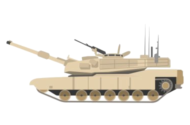

 Military, defense and equipment
 Mitglieder der NATO
Montenegro
Mitglieder der NATO
Montenegro
 NATO summit
Netherlands
Nordmazedonien
Norwegen
Poland
Portugal
Romania
Sweden
Slovakia
Slovenia
Spain
Czech Republic
Turkey
Hungary
United States
United Kingdom
NATO summit
Netherlands
Nordmazedonien
Norwegen
Poland
Portugal
Romania
Sweden
Slovakia
Slovenia
Spain
Czech Republic
Turkey
Hungary
United States
United Kingdom
 Important International Organizations
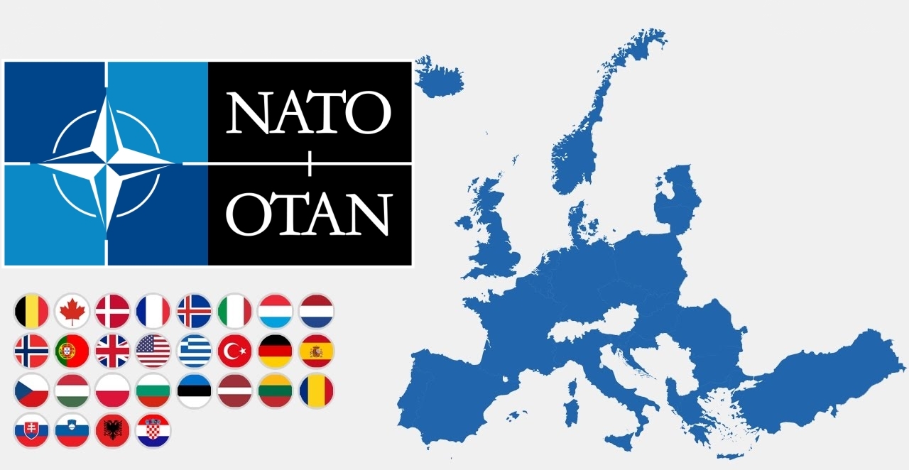
Die NATO (englisch North Atlantic Treaty Organization „Organisation des Nordatlantikvertrags“ bzw. Nordatlantikpakt-Organisation), im Deutschen häufig als Atlantisches Bündnis oder als Nordatlantikpakt bezeichnet (französisch OTAN – Organisation du Traité de l’Atlantique Nord), ist eine Internationale Organisation ohne Hoheitsrechte. Ihre Mitgliedstaaten behalten ihre volle Souveränität und Unabhängigkeit. Basis der NATO ist der Nordatlantikvertrag nach Artikel 51 der UN-Charta. Ihre Organisation versteht sich nicht nur als Verteidigungsbündnis, sondern auch als militärisch-politische Organisation von 29 europäischen und nordamerikanischen Mitgliedstaaten mit dem Ziel eigener Sicherheit und weltweiter Stabilität.
Das NATO-Hauptquartier beherbergt den Nordatlantikrat (das Hauptorgan der NATO) und seine unmittelbar nachgeordneten Einrichtungen, den International Staff (IS) und den International Military Staff (IMS); diese Institution hat seit 1967 ihren Sitz in Brüssel. Nach der Unterzeichnung des Nordatlantikpakts am 4. April 1949 – vorerst auf 20 Jahre – war das Hauptquartier zunächst in London ansässig und anschließend von 16. April 1952 bis 1967 in Paris angesiedelt worden.
Die beiden wichtigsten militärischen Hauptquartiere sind das ACO (aus historischen und juristischen Gründen auch als Supreme Headquarters Allied Powers Europe / SHAPE bezeichnet) im belgischen Casteau bei Mons und das Allied Command Transformation (ACT) in der US-Stadt Norfolk (Virginia).
北大西洋公约组织(英语:North Atlantic Treaty Organization,缩写为NATO;法语:Organisation du Traité de l'Atlantique Nord,缩写为OTAN),简称北约组织或北约,是欧洲及北美洲国家为实现防卫合作而建立的国际组织。1949年3月18日,美国、英国及法国公开建立北大西洋公约组织,于同年4月4日在美国华盛顿签署《北大西洋公约》后正式成立。为与以前苏联为首的东欧集团国成员相抗衡。及至苏联解体,华沙条约组织宣告解散,北约就成为一个地区性防卫协作组织。北约的最高决策机构是北约理事会。理事会由成员国国家元首及政府高层、外长、国防部长组成。总部设在比利时的布鲁塞尔。最新成员黑山于2017年6月5日加入,至此北约总共有跨域欧洲和北美的29个国家组成。北约军事开支占世界国防开支的70%[4],成员国国防开支占该国GDP的2%左右[5]。
公约第5条规定成员国受到的攻击一旦被确认,其他成员国将作出即时反应。该条款被理解为各国部队将自动参战,并不再次需要各国政府的参战授权。但这一条条款在九一一事件之前,一直都未有动用过[6] 。北约曾协助反海盗行动(counter-piracy operations),在联合国要求下打击亚丁湾、非洲之角和印度洋的海盗[7],并在2011年根据联合国安理会1973号决议将利比亚上空设为禁飞区。
北大西洋条約機構(きたたいせいようじょうやくきこう)は、北大西洋条約に基づき、アメリカ合衆国を中心とした北アメリカ(=アメリカとカナダ)およびヨーロッパ諸国によって結成された軍事同盟である。29カ国が加盟し、日本など非加盟国とも協力関係にある[1]。前身はブリュッセル条約 (1948年)。ベルギー首都ブリュッセルに本部を置く[2]。
略称は頭字語が用いられ、英語圏では、North Atlantic Treaty Organization を略した NATO(ネイトー)と呼ばれ、日本やドイツ語圏では NATO(ナトー)、フランス語圏・スペイン語圏・ポルトガル語圏等では OTAN(オタン)と呼ばれる。
The North Atlantic Treaty Organization (NATO /ˈneɪtoʊ/; French: Organisation du Traité de l'Atlantique Nord; OTAN), also called the North Atlantic Alliance, is an intergovernmental military alliance between 29 North American and European countries. The organization implements the North Atlantic Treaty that was signed on 4 April 1949.[3][4] NATO constitutes a system of collective defence whereby its independent member states agree to mutual defence in response to an attack by any external party. NATO’s Headquarters are located in Haren, Brussels, Belgium, while the headquarters of Allied Command Operations is near Mons, Belgium.
Since its founding, the admission of new member states has increased the alliance from the original 12 countries to 29. The most recent member state to be added to NATO is Montenegro on 5 June 2017. NATO currently recognizes Bosnia and Herzegovina, Georgia, Macedonia and Ukraine as aspiring members.[5] An additional 21 countries participate in NATO's Partnership for Peace program, with 15 other countries involved in institutionalized dialogue programs. The combined military spending of all NATO members constitutes over 70% of the global total.[6] Members have committed to reach or maintain defense spending of at least 2% of GDP by 2024.[7][8]
L’Organisation du traité de l'Atlantique norda (en anglais : North Atlantic Treaty Organization) est l'organisation politico-militaire mise en place par les pays signataires du traité de l'Atlantique nord afin de pouvoir remplir leurs obligations de sécurité et de défense collectives. Elle est le plus souvent désignée par son acronyme OTAN (en anglais NATO) mais aussi fréquemment nommée l’Alliance atlantique, plus rarement l’Alliance euro-atlantique ou l’Alliance transatlantique5, ou parfois, encore plus brièvement, simplement l’Alliance.
Le texte de ce traité, signé le 4 avril 1949, établit le Conseil de l'Atlantique nord (CAN), et lui donne mission de mettre en place l'organisation nécessaire à son application. Le choc provoqué par le déclenchement de la guerre de Corée conduit le CAN à décider fin 1950 la création d'une organisation militaire intégrée permanente, qui constitue encore actuellement la marque distinctive de l'OTAN et lui assure des capacités militaires qu'aucune autre alliance de défense ne possède. Sous le vocable OTAN, l'usage a prévalu d'englober l'alliance juridiquement conclue par les pays signataires du traité de l'Atlantique nord, et l'organisation civile et militaire mise en place pour en rendre opérants les objectifs. La France toutefois a fait exception en décidant en 1966, tout en restant membre de l'Alliance atlantique, de quitter l'organisation militaire intégrée, dont elle est redevenue membre à part entière en 2009.
L'Alliance voit le jour dans le contexte général des débuts de la guerre froide et plus spécifiquement pendant le blocus de Berlin exercé par les Soviétiques. Elle a pour vocation initiale d'assurer la sécurité de l'Europe occidentale en instaurant un couplage fort avec les États-Unis, seul moyen aux yeux des Européens après la Seconde Guerre mondiale de se prémunir contre toute tentative expansionniste de l'Union soviétique. Selon le mot de son premier secrétaire général, Lord Ismay, le rôle de l'OTAN consiste à « garder les Russes à l'extérieur, les Américains à l'intérieur et les Allemands sous tutelle »b. L'OTAN constitue le noyau dur du bloc de l'Ouest. Entre 1955 et 1991, l'adversaire désigné de l'OTAN est le pacte de Varsovie formé par les Soviétiques à la suite de l'adhésion de la RFA à l'Alliance atlantique et à son réarmement. L'OTAN s'organise donc pour faire face à cette menace par la définition de concepts stratégiques touchant notamment les questions relatives aux armes nucléaires, par la planification coordonnée entre tous ses membres de leurs moyens militaires, et par des commandements intégrés par zone géographique, dont le SHAPE est de loin le plus important.
Depuis la dissolution de l'URSS et la fin de la guerre froide en 1991, l'Alliance atlantique a perduré malgré la disparition de sa principale raison d'être initiale. Elle a procédé à son élargissement à d'anciens pays du bloc de l'Est et d'anciennes républiques de l'Union soviétique. Elle a pris en compte de nouvelles crises et menaces comme les conflits nationalistes dans l'ex-Yougoslavie, l'essor du terrorisme international ou la prolifération des armes de destruction massive, en conséquence de quoi l'OTAN a revu en profondeur son concept stratégique et son organisation civile et militaire à plusieurs reprises. Elle a développé une politique systématique de partenariats en Europe et dans le monde, au titre de laquelle les pays de l'Alliance ont établi depuis 1994 un partenariat pour la paix (PPP) avec la Russie, les pays de sa zone d'influence et avec les pays neutres d'Europe occidentale. L'OTAN a aussi mis en place en 2002 avec l'UE une relation privilégiée, l'Identité européenne de sécurité et de défense (IESD), qui permet à cette dernière de bénéficier de moyens de l'OTAN pour certaines opérations entrant dans le cadre de sa politique de sécurité et de défense commune.
Le siège de l'OTAN, initialement situé à Londres puis à Paris (dans les locaux désormais occupés par l'université Paris-Dauphine - PSL) se trouve depuis 1966 à Haren (Bruxelles), et son principal commandement militaire, le SHAPE, initialement installé à Rocquencourt (France), se trouve aujourd'hui à Maisières (Mons), également en Belgique.
L'Organizzazione del Trattato dell'Atlantico del Nord (in inglese North Atlantic Treaty Organization, in sigla NATO,[3] in francese: Organisation du Traité de l'Atlantique Nord, in sigla OTAN) è un'organizzazione internazionale per la collaborazione nel settore della difesa.
Il trattato istitutivo della NATO, il Patto Atlantico, fu firmato a Washington il 4 aprile 1949, ovvero nell'immediato secondo dopoguerra, ed entrò in vigore il 24 agosto dello stesso anno. Attualmente, fanno parte della NATO 29 stati del mondo.
La Organización del Tratado del Atlántico Norte u OTAN (en inglés: North Atlantic Treaty Organization o NATO; en francés: Organisation du Traité de l'Atlantique Nord u OTAN), también denominada Alianza del Atlántico, Alianza del Atlántico Norte o Alianza Atlántica, es una alianza militar intergubernamental basada en el Tratado del Atlántico Norte o Tratado de Washington firmado el 4 de abril de 1949. La organización constituye un sistema de defensa colectiva, en la cual los Estados miembros acuerdan defender a cualquiera de sus miembros si son atacados por una potencia externa.3
La sede de la OTAN se encuentra en Bruselas, Bélgica, uno de los veintinueve Estados miembros de la organización que se extiende por Norteamérica y Europa. La última incorporación fue Montenegro, en junio de 2017. Además, veintiún países colaboran con la OTAN dentro del programa Asociación para la Paz, con otros quince involucrados en programas de diálogo y nueve como socios globales. En 2017, el gasto militar combinado de los veintinueve países fue el 52 % del gasto militar mundial.45
En sus primeros años, la OTAN no era mucho más que una asociación política. Sin embargo, la guerra de Corea hizo que se planteara una coalición permanente. Entonces se creó una estructura militar bajo la dirección de los comandantes de Estados Unidos. La Guerra Fría llevó a las naciones rivales a crear el Pacto de Varsovia en 1955.
Siempre se han manifestado dudas sobre la alianza europeo-norteamericana ante una invasión soviética, desacuerdos que se plasmaron con la creación por parte de Francia de la fuerza de choque nuclear y con su retirada de la estructura militar de la alianza entre 1966 y 2009.
Después de la caída del Muro de Berlín en 1989, la organización intervino dentro de la guerra de Yugoslavia, lo que se convirtió en la primera intervención conjunta de la OTAN. En lo político la organización ha mejorado sus relaciones con los antiguos miembros del bloque del Este, dando como resultado la incorporación a la OTAN de varios miembros del Pacto de Varsovia.
La única ocasión en que un país miembro invocó el artículo 5 del tratado reivindicando la ayuda en su defensa, fue Estados Unidos en 2001.6 Desde entonces, los miembros colaboraron con los Estados Unidos en la guerra de Afganistán. El artículo 4 del tratado prevé llamar a consulta a los miembros y ha sido convocado cuatro veces, tres de ellas por Turquía, la primera por la guerra de Irak y las dos restantes por ataques recibidos durante la guerra civil siria,7 la cuarta ha sido invocada por Polonia durante la crisis de Crimea de 2014, debido a la movilización de tropas rusas en la frontera polaca con Kaliningrado y las maniobras rusas en el mar Báltico.
НА́ТО, Организа́ция Североатланти́ческого догово́ра, Североатлантический Альянс (англ. North Atlantic Treaty Organization, NATO; фр. Organisation du traité de l'Atlantique Nord, OTAN) — военно-политический блок, объединяющий большинство стран Европы, США и Канаду. Основан 4 апреля 1949 года в США, с целью защиты Европы от советского влияния[~ 1][~ 2][~ 3][~ 4][~ 5]. Тогда государствами — членами НАТО стали 12 стран: США, Канада, Исландия, Великобритания, Франция, Бельгия, Нидерланды, Люксембург, Норвегия, Дания, Италия и Португалия. Это «трансатлантический форум» для проведения странами-союзниками консультаций по любым вопросам, затрагивающим жизненно важные интересы его членов, включая события, способные поставить под угрозу их безопасность. Одной из декларированных целей НАТО является обеспечение сдерживания любой формы агрессии в отношении территории любого государства — члена НАТО или защиты от неё.
В настоящее время членами НАТО являются 29 стран. Военные расходы всех членов НАТО в совокупности составляют более 70 процентов от общемирового объёма[1].


Das Dinarische Gebirge (auch als Dinarische Alpen oder Dinariden bezeichnet) gehört zu den jungalpidischen Faltengebirgen in Südosteuropa und ist ein Teilabschnitt des den Mittelmeerraum umspannenden Faltungsgürtels. Es erstreckt sich über 600 Kilometer entlang des Ostufers der Adria von den Julischen Alpen in Nordostitalien und Slowenien über Nordwest-Kroatien, Bosnien-Herzegowina, Südwest-Serbien und Montenegro bis nach Nordalbanien, wo es im Querriegel des Prokletije (Albanische Alpen) abschließt.
Das großteils verkarstete Gebirge zeigt alle Typformen des außertropischen Karstformenschatzes. Aufgrund starker (neo-)tektonischer Aktivität der adriatischen Mikroplatte verfügt es wegen seiner treppenartig angeordneten Relieffolge und tektonisch angelegter Groß-Poljen – sogenannten Poljentreppe – über eines der komplexesten Karstreliefs der Erde.[1] Aus den in den dinarischen Ländern gebräuchlichen regionalen Landschafts- und Relief-Toponymen hat sich ein Großteil der geologischen und geomorphologischen Begriffe zur Karstterminologie entlehnt.
迪纳拉山脉(克罗地亚语:Dinarsko gorje;塞尔维亚语:Динарски Алпи;英语:Dinaric Alps)是欧洲东南部的一条主要山脉,西起阿尔卑斯山脉,沿亚得里亚海海岸向东南延伸约645千米,东隔多瑙河流域与喀尔巴阡山脉相望,向南延伸为希腊境内诸山脉和爱琴海诸岛。
迪纳拉山脉是欧洲第四大山脉,仅次于高加索山脉、斯堪的纳维亚山脉和阿尔卑斯山脉,跨斯洛文尼亚、克罗地亚、波斯尼亚和黑塞哥维那、塞尔维亚、黑山、阿尔巴尼亚和科索沃,最高点为阿尔巴尼亚境内的湖泊峰,海拔2692米。
*Mediterranean Sea
Egypt
Albania
Algeria
Amber Road
Bosnia Herzegovina
France
Gibraltar
Greece
Israel
Italy
Croatia
Libanon
Libya
Malta
Malta
Monaco
Montenegro
Palestine
Slovenia
Spain
Syria
Tunisia
Turkey
Cyprus
Das Mittelmeer (lateinisch Mare Mediterraneum,[1] deshalb deutsch auch Mittelländisches Meer, präzisierend Europäisches Mittelmeer, im Römischen Reich Mare Nostrum) ist ein Mittelmeer zwischen Europa, Afrika und Asien, ein Nebenmeer des Atlantischen Ozeans und, da es mit der Straße von Gibraltar nur eine sehr schmale Verbindung zum Atlantik besitzt, auch ein Binnenmeer. Im Arabischen und Türkischen wird es auch als „Weißes Meer“ (البحر الأبيض/al-baḥr al-abyaḍ bzw. türk. Akdeniz) bezeichnet.
Zusammen mit den darin liegenden Inseln und den küstennahen Regionen Südeuropas, Vorderasiens und Nordafrikas bildet das Mittelmeer den Mittelmeerraum, der ein eigenes Klima (mediterranes Klima) hat und von einer eigenen Flora und Fauna geprägt ist.
地中海(英文:Mediterranean),被北面的欧洲大陆、南面的非洲大陆以及东面的亚洲大陆包围着。东西长约4000千米,南北最宽处大约为1800千米,面积251.6万平方千米,是地球上最大的陆间海。地中海的平均深度是1500米,最深处为5267米。
地中海西部通过直布罗陀海峡与大西洋相接,东部通过土耳其海峡(达达尼尔海峡和博斯普鲁斯海峡、马尔马拉海)和黑海相连。19世纪时开通的苏伊士运河,接通了地中海与红海。地中海是世界上最古老的海之一[3],而其附属的大西洋却是年轻的海洋。地中海处在欧亚板块和非洲板块交界处,是世界最强地震带之一。地中海地区有维苏威火山、埃特纳火山。
地中海作为陆间海,风浪较小,加之沿岸海岸线曲折、岛屿众多,拥有许多天然良好的港口,成为沟通三个大陆的交通要道。这样的条件,使地中海从古代开始海上贸易就很繁盛,促进了古代古埃及文明、古希腊文明、罗马帝国等的发展。现在也是世界海上交通的重要地区之一。其沿岸的腓尼基人、克里特人、希腊人,以及后来的葡萄牙人和西班牙人都是航海业发达的民族。著名的航海家如哥伦布、达·伽马、麦哲伦等,都出自地中海沿岸的国家。
地中海沿岸夏季炎热干燥,冬季温暖湿润,被称作地中海性气候。植被,叶质坚硬,叶面有蜡质,根系深,有适应夏季干热气候的耐旱特征,属亚热带常绿硬叶林。这里光热充足,是欧洲主要的亚热带水果产区,盛产柑橘、无花果,和葡萄等,还有木本油料作物油橄榄。
地中海(ちちゅうかい、ラテン語: Mare Mediterraneum)は、北と東をユーラシア大陸、南をアフリカ大陸(両者で世界島)に囲まれた地中海盆地に位置する海である。面積は約3000平方キロメートル、平均水深は約1500メートル[2]。海洋学上の地中海の一つ。
地中海には、独立した呼称を持ついくつかの海域が含まれる(エーゲ海、アドリア海など)。地中海と接続する他の海としては、ジブラルタル海峡の西側に大西洋が、ダーダネルス海峡を経た北東にマルマラ海と黒海があり、南西はスエズ運河で紅海と結ばれている(「海域」「地理」で詳述)。
北岸の南ヨーロッパ、東岸の中近東、南岸の北アフリカは古代から往来が盛んで、「地中海世界」と総称されることもある[3]。
The Mediterranean Sea is a sea connected to the Atlantic Ocean, surrounded by the Mediterranean Basin and almost completely enclosed by land: on the north by Southern Europe and Anatolia, on the south by North Africa and on the east by the Levant. Although the sea is sometimes considered a part of the Atlantic Ocean, it is usually identified as a separate body of water. Geological evidence indicates that around 5.9 million years ago, the Mediterranean was cut off from the Atlantic and was partly or completely desiccated over a period of some 600,000 years, the Messinian salinity crisis, before being refilled by the Zanclean flood about 5.3 million years ago.
It covers an approximate area of 2.5 million km2 (965,000 sq mi), but its connection to the Atlantic (the Strait of Gibraltar) is only 14 km (8.7 mi) wide. The Strait of Gibraltar is a narrow strait that connects the Atlantic Ocean to the Mediterranean Sea and separates Gibraltar and Spain in Europe from Morocco in Africa. In oceanography, it is sometimes called the Eurafrican Mediterranean Sea or the European Mediterranean Sea to distinguish it from mediterranean seas elsewhere.[2][3]
The Mediterranean Sea has an average depth of 1,500 m (4,900 ft) and the deepest recorded point is 5,267 m (17,280 ft) in the Calypso Deep in the Ionian Sea. The sea is bordered on the north by Europe, the east by Asia, and in the south by Africa. It is located between latitudes 30° and 46° N and longitudes 6° W and 36° E. Its west-east length, from the Strait of Gibraltar to the Gulf of Iskenderun, on the southwestern coast of Turkey, is approximately 4,000 km (2,500 miles). The sea's average north-south length, from Croatia’s southern shore to Libya, is approximately 800 km (500 miles). The Mediterranean Sea, including the Sea of Marmara (connected by the Dardanelles to the Aegean Sea), has a surface area of approximately 2,510,000 square km (970,000 square miles).[4]
The sea was an important route for merchants and travellers of ancient times that allowed for trade and cultural exchange between emergent peoples of the region. The history of the Mediterranean region is crucial to understanding the origins and development of many modern societies.
The countries surrounding the Mediterranean in clockwise order are Spain, France, Monaco, Italy, Slovenia, Croatia, Bosnia and Herzegovina, Montenegro, Albania, Greece, Turkey, Syria, Lebanon, Israel, Egypt, Libya, Tunisia, Algeria, and Morocco; Malta and Cyprus are island countries in the sea. In addition, the Gaza Strip and the British Overseas Territories of Gibraltar and Akrotiri and Dhekelia have coastlines on the sea.
La mer Méditerranée (prononcé [me.di.tɛ.ʁa.ne]) est une mer intercontinentale presque entièrement fermée, bordée par les côtes d'Europe du sud, d’Afrique du Nord et d’Asie, depuis le détroit de Gibraltar à l'ouest aux entrées des Dardanelles et du canal de Suez à l'est. Elle s’étend sur une superficie d’environ 2,5 millions de kilomètres carrés. Son ouverture vers l’océan Atlantique par le détroit de Gibraltar est large de 14 kilomètres.
Elle doit son nom au fait qu’elle est littéralement une « mer au milieu des terres », en latin « mare medi terra »1.
Durant l’Antiquité, la Méditerranée était une importante voie de transports maritimes permettant l’échange commercial et culturel entre les peuples de la région — les cultures mésopotamiennes, égyptienne, perse, phénicienne, carthaginoise, berbère, grecque, arabe (conquête musulmane), ottomane, byzantine et romaine. L’histoire de la Méditerranée est importante dans l’origine et le développement de la civilisation occidentale.
Il mar Mediterraneo, detto brevemente Mediterraneo, è un mare intercontinentale situato tra Europa, Nordafrica e Asia occidentale connesso all'Oceano Atlantico. La sua superficie approssimativa è di 2,51 milioni di km² e ha uno sviluppo massimo lungo i paralleli di circa 3 700 km. La lunghezza totale delle sue coste è di 46 000 km, la profondità media si aggira sui 1 500 m, mentre quella massima è di 5 270 m presso le coste del Peloponneso. La salinità media si aggira dal 36,2 al 39 ‰.[2] La popolazione presente negli stati bagnati dalle sue acque ammonta a circa 450 milioni di persone.[2].
El mar Mediterráneo es uno de los mares del Atlántico. Está rodeado por la región mediterránea, comprendida entre Europa meridional, Asia Occidental y África septentrional. Fue testigo de la evolución de varias civilizaciones como los egipcios, los fenicios, hebreos, griegos, cartagineses, romanos, etc. Con aproximadamente 2,5 millones de km² y 3.860 km de longitud, es el segundo mar interior más grande del mundo, después del Caribe.1 Sus aguas, que bañan las tres penínsulas del sur de Europa (Ibérica, Itálica, Balcánica) y una de Asia (Anatolia), comunican con el océano Atlántico a través del estrecho de Gibraltar, con el mar Negro por los estrechos del Bósforo y de los Dardanelos y con el mar Rojo por el canal de Suez.2 Es el mar con las tasas más elevadas de hidrocarburos y contaminación del mundo.3
Средизе́мное мо́ре — межматериковое море, по происхождению представляющее собой глубоководную псевдоабиссальную внутришельфовую депрессию[1][2], связанную на западе с Атлантическим океаном Гибралтарским проливом[3].
В Средиземном море выделяют, как его составные части, моря: Адриатическое, Альборан, Балеарское, Ионическое, Кипрское, Критское, Левантийское, Ливийское, Лигурийское, Тирренское и Эгейское. В бассейн Средиземного моря также входят Мраморное, Чёрное и Азовское моря.