
Deutsch-Chinesische Enzyklopädie, 德汉百科
 Canada
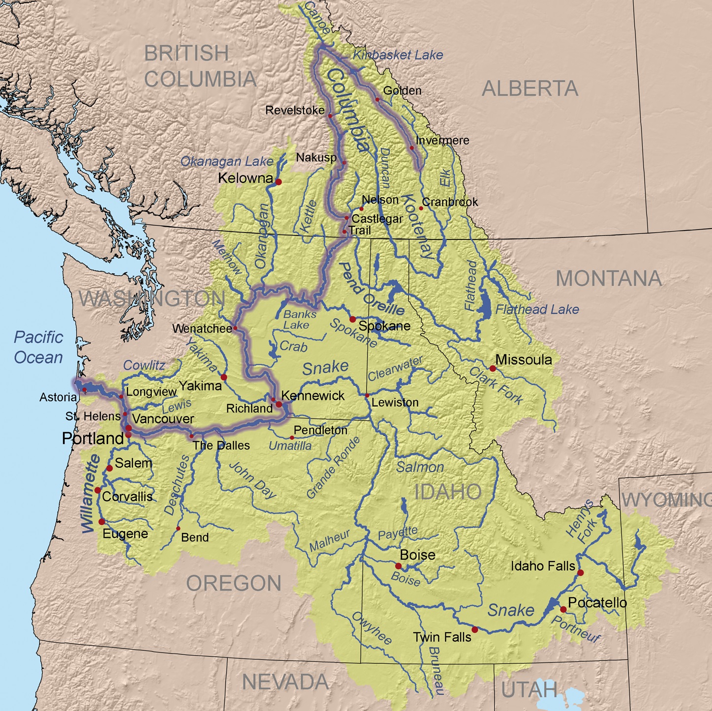
Der Columbia River ist ein 1953 Kilometer langer Fluss im westlichen Nordamerika. Er ist der wasserreichste aller nordamerikanischen Flüsse, die in den Pazifischen Ozean münden.
Mit seinem linken Nebenfluss, dem Snake River, zusammen hat er eine Länge von 2240 km. Sein Einzugsgebiet umfasst 668.217 km², wovon etwa 15 % innerhalb Kanadas[1] liegen.
Der Fluss ist nach dem Schiff Columbia Rediviva des US-amerikanischen Kapitäns Robert Gray benannt, der am 11. Mai 1792 als erster Weißer den Columbia River hinauffuhr. Gray reiste in den pazifischen Nordwesten, um mit Fellen zu handeln.[2]
Die Lewis-und-Clark-Expedition erreichte 1805 vom Osten auf dem Landweg die Mündung des Flusses. Der Columbia River wurde 1814 erstmals vollständig von David Thompson kartografiert.
Von den 1820er Jahren bis in die 1840er Jahre folgte der York Factory Express, eine Handelsroute der Hudson’s Bay Company zwischen der York Factory an der Hudson Bay und dem Fort Vancouver, abschnittsweise dem Flusslauf.
コロンビア川(コロンビアがわ、Columbia River)は、カナダのブリティッシュコロンビア州およびアメリカ合衆国太平洋岸北西部を流れる川である。
ブリティッシュコロンビア州のカナディアンロッキーに源を発する。そこからアメリカ、ワシントン州を流れ、ポートランドにて支流のウィラメット川を合わせ、オレゴン州のアストリアにて太平洋に注ぐ。最後の480kmはワシントン州とオレゴン州の境界となっている。
コロンビア川には、ボンネビル・ダム、グランドクーリーダムなどの水力発電用のダムがある。
マンハッタン計画以来半世紀間操業したハンフォード・サイトのプルトニウム生産炉による放射能汚染が深刻な問題となっている。
The Columbia River (Upper Chinook: Wimahl or Wimal; Sahaptin: Nch’i-Wàna or Nchi wana; Sinixt dialect swah'netk'qhu) is the largest river in the Pacific Northwest region of North America.[10] The river rises in the Rocky Mountains of British Columbia, Canada. It flows northwest and then south into the US state of Washington, then turns west to form most of the border between Washington and the state of Oregon before emptying into the Pacific Ocean. The river is 1,243 miles (2,000 km) long, and its largest tributary is the Snake River. Its drainage basin is roughly the size of France and extends into seven US states and a Canadian province. The fourth-largest river in the United States by volume, the Columbia has the greatest flow of any North American river entering the Pacific.
The Columbia and its tributaries have been central to the region's culture and economy for thousands of years. They have been used for transportation since ancient times, linking the region's many cultural groups. The river system hosts many species of anadromous fish, which migrate between freshwater habitats and the saline waters of the Pacific Ocean. These fish—especially the salmon species—provided the core subsistence for native peoples.
The first documented European discovery of the Columbia River was that of Bruno de Heceta, who in 1775 sighted the river's mouth. In the late 18th century, a private American ship became the first non-indigenous vessel to enter the river; it was followed by a British explorer, who navigated past the Oregon Coast Range into the Willamette Valley. In the following decades, fur trading companies used the Columbia as a key transportation route. Overland explorers entered the Willamette Valley through the scenic but treacherous Columbia River Gorge, and pioneers began to settle the valley in increasing numbers. Steamships along the river linked communities and facilitated trade; the arrival of railroads in the late 19th century, many running along the river, supplemented these links.
Since the late 19th century, public and private sectors have heavily developed the river. To aid ship and barge navigation, locks have been built along the lower Columbia and its tributaries, and dredging has opened, maintained, and enlarged shipping channels. Since the early 20th century, dams have been built across the river for power generation, navigation, irrigation, and flood control. The 14 hydroelectric dams on the Columbia's main stem and many more on its tributaries produce more than 44 percent of total US hydroelectric generation. Production of nuclear power has taken place at two sites along the river. Plutonium for nuclear weapons was produced for decades at the Hanford Site, which is now the most contaminated nuclear site in the US. These developments have greatly altered river environments in the watershed, mainly through industrial pollution and barriers to fish migration.
Le Columbia (se prononce /kə.lʌm.bi.ə/ ou « co-lemb-bia » et se nomme Columbia River /kə.lʌm.bi.ə ˈɹɪvəɹ/ en anglais) est un fleuveNote 1 circulant du Canada aux États-Unis avant de se jeter dans l'océan Pacifique.
C'est le plus grand cours d'eau de la région Nord-Ouest Pacifique de l'Amérique du Nord, que ce soit par sa longueur totale, la taille du bassin versant ou son débit à l'embouchure. Il prend sa source dans les montagnes Rocheuses en Colombie-Britannique, au Canada, puis coule dans les États américains de Washington et de l'Oregon avant de se jeter dans l'océan Pacifique à la hauteur de la ville d'Astoria. Le fleuve mesure environ 2 000 kilomètres et son principal affluent est la Snake. Son bassin versant est d'environ 670 000 kilomètres carrés, soit un peu plus que la taille de la France, et s'étend sur sept États américains et une province canadienne.
Le Columbia est le quatrième fleuve des États-Unis par son volume et est celui des fleuves d'Amérique du Nord qui se jettent dans l'océan Pacifique qui a le plus grand débit. Son débit abondant et son dénivelé relativement important lui donnent un énorme potentiel pour la production d'énergie hydroélectrique. Les quatorze barrages hydroélectriques sur le cours principal du Columbia produisent à eux seuls plus d'énergie hydroélectrique que ceux de tout autre fleuve nord-américain.
Le Columbia et ses affluents ont été au centre de la culture et de l'économie de la région depuis des milliers d'années. Ils ont été utilisés pour le transport et comme axe de communication, reliant les nombreux groupes de populations de la région. Le système fluvial accueille de nombreuses espèces de poissons anadromes qui migrent entre les habitats d'eau douce et de mer de l'océan Pacifique. Ces poissons, surtout les espèces de saumons, fournirent une nourriture de base pour les peuples autochtones et, dans les siècles passés, les commerçants de tout l'Ouest de l'Amérique du Nord sont venus commercer ces poissons.
À la fin du XVIIIe siècle, le Columbia Rediviva, un navire américain, devint le premier à entrer dans l'embouchure du fleuve depuis l'océan Pacifique, et son commandant Robert Gray nomma sa découverte du nom de son bateau. Il fut suivi par l'explorateur britannique William Robert Broughton qui explora la chaîne côtière de l'Oregon dans la vallée de la Willamette. Dans les décennies suivantes, les compagnies commerciales de traite des fourrures utilisèrent le Columbia comme une voie de transport clé. Les explorateurs à terre venus de l'est entrèrent dans la vallée de la Willamette par la gorge du Columbia et les pionniers commencèrent à s'installer dans la vallée de la Willamette en nombre croissant depuis les deux voies d'accès découvertes. Les bateaux à vapeur naviguant le long du fleuve facilitèrent le commerce et les communications et l'arrivée du chemin de fer à la fin du XIXe siècle, avec des lignes suivant le lit du fleuve, permit de compléter ces liens.
Depuis la fin du XIXe siècle, les installations diverses, privées et publiques, se sont fortement développées sur le fleuve. Pour faciliter la navigation des navires et des barges, des écluses ont été construites le long du bas Columbia et de ses affluents, et le dragage a ouvert et maintenu des chenaux de navigation praticables. Dès le début du XXe siècle, des barrages furent construits sur le fleuve pour la production d'électricité, la navigation, l'irrigation agricole et le contrôle des inondations. Au début des années 2010, du côté américain, un lac de barrage est présent presque tous les milles sur le fleuve. La production d'énergie nucléaire a lieu sur deux sites le long du fleuve et du plutonium pour des armes nucléaires a été produit pendant des décennies sur le site du laboratoire national de Hanford, qui est maintenant le site nucléaire le plus contaminé aux États-Unis. Toutes ces évolutions eurent un impact énorme sur les écosystèmes locaux, et peut-être plus particulièrement par la pollution industrielle et les obstacles à la migration des poissons.
Il Columbia è il fiume più grande sfociante nel Pacifico nord-occidentale, in Nord America.
Il fiume nasce dalle Montagne Rocciose della Columbia Britannica, in Canada. Scorre con andamento nord-ovest e poi verso sud, entrando negli Stati Uniti d'America, nello stato di Washington; successivamente inizia a scorrere verso ovest per fungere da confine tra Washington e l'Oregon, prima di sfociare nell'Oceano Pacifico. La lunghezza del fiume è di 2.000 km, e il suo più grande affluente lo Snake. Il suo bacino idrografico ha quasi le dimensioni della Francia.
Il Columbia è il quarto fiume più grande degli Stati Uniti, ed il fiume con più portata tra quelli sfocianti nel Pacifico nord-occidentale. L'enorme portata e la relativa velocità delle sue acque conferiscono al Columbia un enorme potenziale per la generazione di energia idroelettrica. Le 14 dighe poste sul fiume, e quelle poste lungo il corso degli affluenti, producono più energia di qualsiasi altro fiume nordamericano.
Il fiume e i suoi affluenti sono stati per migliaia di anni molto importanti per la cultura e l'economia delle regioni che attraversano. Essi sono stati utilizzati per il trasporto fin dall'antichità, collegando un sistema di culture molto diverse tra loro. Le fasce fluviali del Columbia e dei suoi affluenti ospitano molte specie di pesci anadromi, che migrano dalle acque dolci a quelle salate dell'Oceano Pacifico. Questi pesci, soprattutto il salmone, sono stati fondamentali per la sopravvivenza dei nativi e per i commercianti provenienti da tutto il Nord America.
El río Columbia (también conocido como Wimahl o Gran Río por los nativos de los pueblos chinook que viven en su curso bajo) es un río del suroeste de Canadá y noroeste de Estados Unidos que fluye en dirección norte-sur-oeste por la provincia de Columbia Británica, en Canadá, y los estados de Washington y Oregón en Estados Unidos, desembocando en el océano Pacífico. Con 2044 km es el sexto río más largo de América del Norte, por detrás del Misuri, Misisipi, Bravo, Arkansas y Colorado.
Toma el nombre del Columbia Rediviva, el primer barco occidental conocido que haya remontado el río. Nace en la provincia canadiense de la Columbia Británica y tras cruzar el estado de Washington (EE. UU.) y luego delimitar gran parte de la separación administrativa entre los estados de Washington y Oregón, desemboca en el Pacífico. Su cuenca hidrográfica, que drena gran parte de la Columbia Británica, Idaho, Oregón, Washington y pequeñas regiones de Montana, Wyoming, Utah y Nevada, comprende 668 000 km².
En términos de caudal (7500 m³/s en su desembocadura), el Columbia es el río de Norteamérica más caudaloso de la vertiente del Pacífico y el cuarto más caudaloso de los Estados Unidos. La fuerte corriente del río y el elevado salto o descenso de altura en una relativamente corta longitud, le proporciona un tremendo potencial de producción de electricidad que ya ha sido explotado, siendo el río que más energía hidroeléctrica produce de Norteamérica, con catorce presas a lo largo de su curso —tres en Canadá y once en Estados Unidos— y otras muchas en varios de sus afluentes.
Su desembocadura fue descubierta y cartografiada en 1775 por el buque español Santiago al mando del comandante Bruno de Heceta. En 1792 fue explorado por el comerciante y aventurero estadounidense Robert Gray. Entre 1807 y 1811, la peletera Compañía del Noroeste explotó todo su curso. Desde la década de 1810 el río sirvió como vía de comunicación en la región noroccidental del subcontinente.1
Después del establecimiento de numerosos asentamientos estadounidenses y europeos en sus orillas, el río Columbia ha prestado muchos servicios para el desarrollo de los propósitos humanos, incluyendo trabajos de draga para permitir la navegación de mayores barcos por sus aguas, la construcción de presas para la generación de electricidad, agua para el riego de cultivos y control de crecidas e inundaciones, e incluso para refrigerar instalaciones de energía nuclear. Todos esos proyectos han entrado en conflicto con la conservación del medioambiente y el movimiento de especies píscicolas y animales, produciendo una contaminación indeseada en sus aguas.
Колумбия (англ. Columbia River) — река на северо-западе Северной Америки[1]. Пересекает канадскую провинцию Британская Колумбия, а также американские штаты Вашингтон и Орегон. Длина — 2000[2] км.
Полноводная Колумбия имеет ледниковое питание и горный скоротечный характер течения. Большой объём воды и значительный перепад высот на относительно короткой дистанции создаёт благоприятные условия для производства гидроэлектроэнергии. Колумбия является рекой с самым большим производством электроэнергии в Северной Америке. На реке построено 14 гидроэлектростанций как в США, так и в Канаде.
Первыми из европейцев по реке спустились участники экспедиции Льюиса и Кларка 1805—1807 годов. В 1806—1811 годах бассейн реки обследовал и нанёс на карту торговец пушниной и картограф Дэвид Томпсон. Он же стал первым, кто прошёл реку от истоков до устья.


 *UK political system
 Antigua and Barbuda
 Australia
 Bahamas
 Bangladesh
 Barbados
 Belize
 Botsuana
 Brunei Darussalam
 Commonwealth of Nations
 Dominica
 Ghana
Ghana
 Grenada
 Guyana
 India
India
 Jamaika
 Cameroon
 Canada
 Kenya
Kenya
 Kiribati
 Lesotho
 Malawi
 Malaysia
 Malediven
 Malta
Malta
 Mosambik
 Namibia
 Nauru
Nauru
 New Zealand
 Nigeria
 Pakistan
 Papua-Neuguinea
 Salomonen
 Sambia
 Samoa
Samoa
 Seychellen
 Sierra Leone
 Singapore
 Sri Lanka
 Saint Kitts and Nevis
 St. Vincent and the Grenadines
 South Africa
 Swasiland
 Tansania
 Tonga
Tonga
 Trinidad und Tobago
 Tuvalu
 Uganda
 Vanuatu
 United Kingdom

 Important International Organizations
 Cyprus
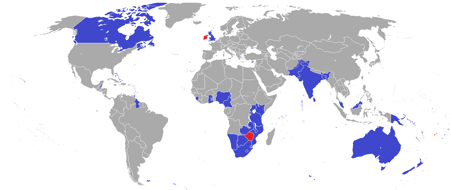
英联邦(英语:Commonwealth of Nations,新马作共和联邦,台湾作大英国协),是一个现代的国际组织,由56个英语系的主权国家联合而成。
英联邦不是一个统一的联邦国家,而是一个国际组织,英联邦也无权约束旗下任何成员国内政。英联邦元首通常由英国君主兼任,其首任元首是乔治六世,现任是查尔斯三世,但元首并无实权,秘书长才是英联邦实际上的掌权者[4][5]。该组织的成员国基本由英国及其旧殖民地组成,也以英式英语为共通语言,但英国的地位并没有凌驾于他国之上,所有成员国一律平等。目前英联邦有56个成员国,其中15个属于英联邦王国,英联邦王国的国家元首、英联邦元首均和英国的一致,即现在的查尔斯三世;另外5个属于独立君主国,它们不以英国君主为自己的元首,而是自立君主,这五国是文莱、斯威士兰、莱索托、马来西亚、汤加;其余的36个均属于共和国,没有君主。
The Commonwealth of Nations, generally known simply as the Commonwealth,[3] is a political association of 53 member states, nearly all of them former territories of the British Empire.[4] The chief institutions of the organisation are the Commonwealth Secretariat, which focuses on intergovernmental aspects, and the Commonwealth Foundation, which focuses on non-governmental relations between member states.[5]
The Commonwealth dates back to the first half of the 20th century with the decolonisation of the British Empire through increased self-governance of its territories. It was originally created as the British Commonwealth of Nations[6] through the Balfour Declaration at the 1926 Imperial Conference, and formalised by the United Kingdom through the Statute of Westminster in 1931. The current Commonwealth of Nations was formally constituted by the London Declaration in 1949, which modernised the community and established the member states as "free and equal".[7]
The human symbol of this free association is the Head of the Commonwealth, currently Queen Elizabeth II, and the 2018 Commonwealth Heads of Government Meeting appointed Charles, Prince of Wales to be her designated successor, although the position is not technically hereditary. The Queen is the head of state of 16 member states, known as the Commonwealth realms, while 32 other members are republics and five others have different monarchs.
Member states have no legal obligations to one another, but are connected through their use of the English language and historical ties. Their stated shared values of democracy, human rights and the rule of law are enshrined in the Commonwealth Charter[8] and promoted by the quadrennial Commonwealth Games.
The countries of the Commonwealth cover more than 29,958,050 km2 (11,566,870 sq mi), equivalent to 20% of the world's land area, and span all six inhabited continents.
Le Commonwealth ou Commonwealth of Nations (littéralement, la « Communauté des Nations ») est une organisation intergouvernementale composée de 53 États membres qui sont presque tous d'anciens territoires de l'Empire britannique.
Le Commonwealth a émergé au milieu du XXe siècle pendant le processus de décolonisation. Il est formellement constitué par la Déclaration de Londres de 1949 qui fait des États membres des partenaires « libres et égaux ». Le symbole de cette libre association est la reine Élisabeth II qui est chef du Commonwealth. La reine est également le chef d'État monarchique des 16 royaumes du Commonwealth. Les autres États membres sont 32 républiques et cinq monarchies dont le monarque est différent.
Les États membres n'ont aucune obligation les uns envers les autres. Ils sont réunis par la langue, l'histoire et la culture et des valeurs décrites dans la Charte du Commonwealth telles que la démocratie, les droits humains et l'état de droit.
Les États du Commonwealth couvrent 29 958 050 km2 de territoire sur les cinq continents habités. Sa population est estimée à 2,328 milliards d'habitants.
Il Commonwealth delle Nazioni o Commonwealth (acronimo CN) è un'organizzazione intergovernativa di 53 Stati membri indipendenti, tutti accomunati, eccetto il Mozambico e il Ruanda, da un passato storico di appartenenza all'Impero britannico, del quale il Commonwealth è una sorta di sviluppo su base volontaria. La popolazione complessiva degli stati che vi aderiscono è di oltre due miliardi di persone. La parola Commonwealth deriva dall'unione di common (comune) e wealth (benessere), cioè benessere comune.
In passato fu noto anche come Commonwealth britannico, benché tale definizione esistette formalmente solo dalla fondazione nel 1926 fino al 1948.
La Mancomunidad de Naciones (en inglés: Commonwealth of Nations)?, antiguamente Mancomunidad Británica de Naciones (British Commonwealth of Nations), es una organización compuesta por 53 países soberanos independientes y semi independientes que, con la excepción de Mozambique y Ruanda,1 comparten lazos históricos con el Reino Unido. Su principal objetivo es la cooperación internacional en el ámbito político y económico, y desde 1950 la pertenencia a ella no implica sumisión alguna a la Corona británica, aunque se respeta la figura de la reina del Reino Unido. Con el ingreso de Mozambique, la organización ha favorecido el término Mancomunidad de Naciones para subrayar su carácter internacionalista. Sin embargo, el adjetivo británico se sigue utilizando con frecuencia para diferenciarla de otras mancomunidades existentes a nivel internacional.
La reina Isabel II del Reino Unido es la cabeza de la organización, según los principios de la Mancomunidad, «símbolo de la libre asociación de sus miembros».
Содру́жество на́ций (англ. Commonwealth of Nations, до 1946 года — Британское Содружество наций — англ. British Commonwealth of Nations), кратко именуемое просто Содружество (англ. The Commonwealth) — добровольное объединение суверенных государств, в которое входят Великобритания и почти все её бывшие доминионы, колонии и протектораты. Членами Содружества также являются Мозамбик, Руанда, Намибия и Камерун[2].

 Canada
 Mexico
 Mexico
 Mexico
 Mexico
 Mexico
 Mexico
 Mexico
 United States
 United States
 United States
 United States
 United States

 Architecture
 Ontario-ON
 Geography

 British Columbia-BC
 Oregon-OR
 Washington-WA
 Sport
Sport
 Alberta-AB
 Hand in Hand
 European Union
 Economy and trade
 New Brunswick-NB
 Prince Edward Island-PEI