
Deutsch-Chinesische Enzyklopädie, 德汉百科
 Iran
Iran
 Beijing Shi-BJ
 Belarus

 Berlin

 Brandenburg

 Bremen
 China
China
 Germany
 France
 Gansu Sheng-GS

 Hamburg
 Hebei Sheng-HE
 Heilongjiang Sheng-HL
 Henan Sheng-HA
 Hubei Sheng-HB
 Hunan Sheng-HN
 Iran
Iran
 Italy
Italy
 Jilin Sheng-JL
 Kasachstan
 Liaoning Sheng-LN
 Nei Mongol Zizhiqu-NM
 Netherlands

 Lower Saxony
 Ningxia Huizu Zizhiqu-NX

 North Rhine-Westphalia
 Poland
 Portugal
 Russia

 Saxony

 Schleswig-Holstein
 Shaanxi Sheng-SN
 Shandong Sheng-SD
 Shanxi Sheng-SX
 Sichuan Sheng-SC
 Spain
Spain
 Turkey
 Turkmenistan
 Uzbekistan
 United Kingdom
 Xinjiang Uygur Zizhiqu-XJ
 Zhejiang Sheng-ZJ
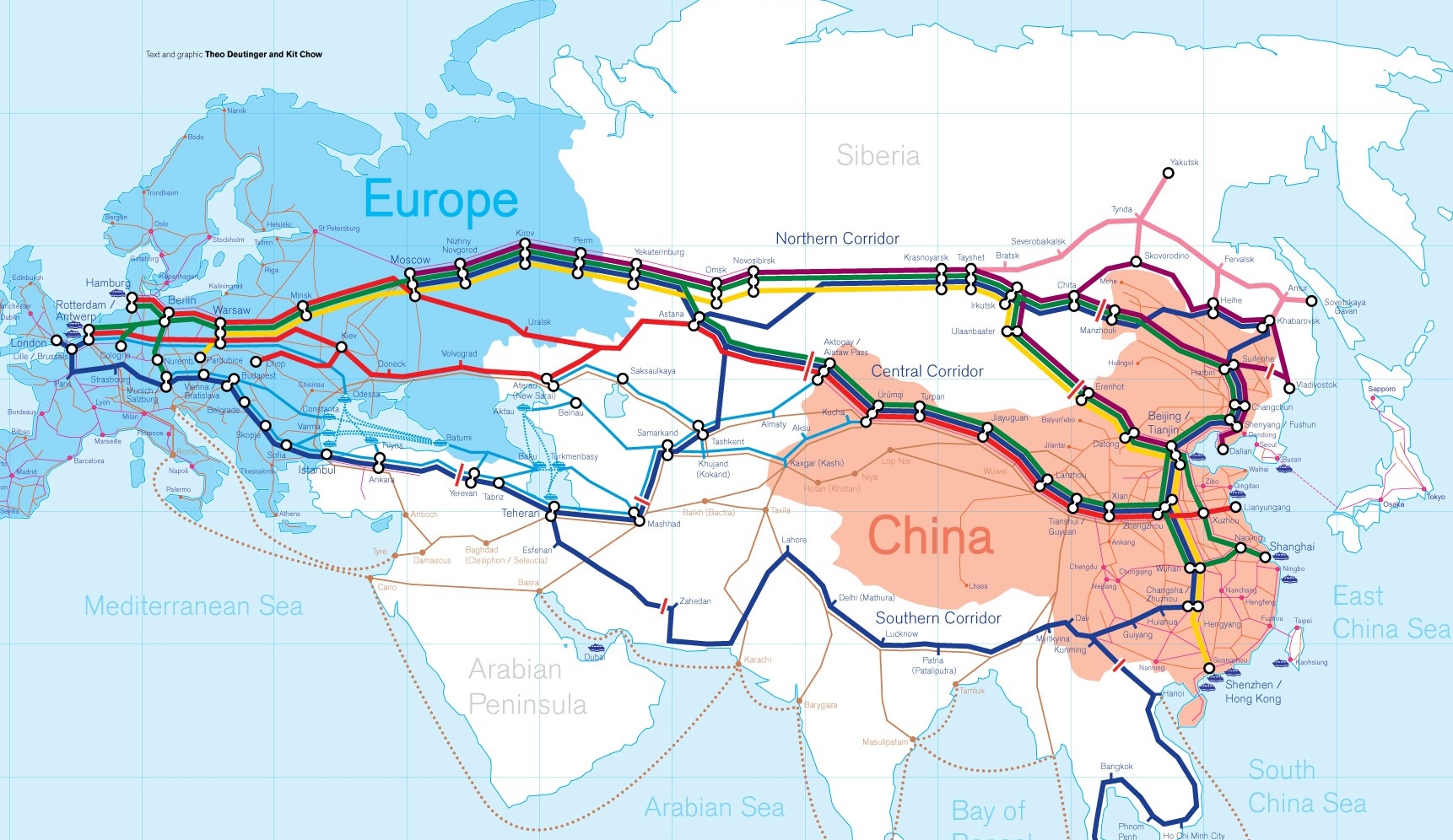
Die Neue eurasische Kontinentalbrücke (chinesisch 新亚欧大陆桥, Pinyin Xīn Yà-Ōu Dàlù Qiáo, englisch New Eurasian Continental Bridge), die auch Zweite eurasische Kontinentalbrücke (第二亚欧大陆桥, Dì'èr Yà-Ōu Dàlù Qiáo, englisch Second Eurasian Continental Bridge) genannt wird, ist eine 10.870 Kilometer[1] lange Eisenbahnverbindung, die Rotterdam in Europa mit der ostchinesischen Hafenstadt Lianyungang in der Provinz Jiangsu verbindet.
Sie besteht seit 1990 und führt durch die Dsungarische Pforte (Grenzbahnhof Alashankou). Die Lan-Xin-Bahn (chinesisch 兰新铁路, Pinyin Lán-Xīn Tiělù), also die Strecke von Lanzhou nach Ürümqi (in Xinjiang), ist ein Teil von ihr.
Es gibt eine nördliche, mittlere und südliche Route.[2] Die mittlere Strecke verläuft durch Kasachstan über Dostyk, Aqtogai, Astana, Samara, Smolensk, Brest, Warschau, Berlin zum Hafen von Rotterdam.[3] Vom slowakischen Košice soll auch eine Abzweigung in den Großraum Wien führen, siehe Breitspurstrecke Košice–Wien.
The New Eurasian Land Bridge, also called the Second or New Eurasian Continental Bridge, is the southern branch of the Eurasian Land Bridge rail links running through China. The Eurasian Land Bridge is the overland rail link between Asia and Europe.
Due to a break-of-gauge between standard gauge used in China and the Russian gauge used in the former Soviet Union countries, containers must be physically transferred from Chinese to Kazakh railway cars at Dostyk on the Chinese-Kazakh border and again at the Belarus-Poland border where the standard gauge used in western Europe begins. This is done with truck-mounted cranes.[1] Chinese media often states that the New Eurasian Land/Continental Bridge extends from Lianyungang to Rotterdam, a distance of 11,870 kilometres (7,380 mi). The exact route used to connect the two cities is not always specified in Chinese media reports, but appears to usually refer to the route which passes through Kazakhstan.
All rail freight from China across the Eurasian Land Bridge must pass north of the Caspian Sea through Russia at some point. A proposed alternative would pass through Turkey and Bulgaria,[2] but any route south of the Caspian Sea must pass through Iran.[1]
Kazakhstan's President Nursultan Nazarbayev urged Eurasian and Chinese leaders at the 18th Shanghai Cooperation Organisation to construct the Eurasian high-speed railway (EHSRW) following a Beijing-Astana-Moscow-Berlin.[3]
The Eurasian Land Bridge (Russian: Евразийский сухопутный мост, Yevraziyskiy sukhoputniy most), sometimes called the New Silk Road (Новый шёлковый путь, Noviy shyolkoviy put'), or Belt and Road Initiative is the rail transport route for moving freight and passengers overland between Pacific seaports in the Russian Far East and China and seaports in Europe. The route, a transcontinental railroad and rail land bridge, currently comprises the Trans-Siberian Railway, which runs through Russia and is sometimes called the Northern East-West Corridor, and the New Eurasian Land Bridge or Second Eurasian Continental Bridge, running through China and Kazakhstan. As of November 2007, about 1% of the $600 billion in goods shipped from Asia to Europe each year were delivered by inland transport routes.[1]
Completed in 1916, the Trans-Siberian connects Moscow with Russian Pacific seaports such as Vladivostok. From the 1960s until the early 1990s the railway served as the primary land bridge between Asia and Europe, until several factors caused the use of the railway for transcontinental freight to dwindle. One factor is that the railways of the former Soviet Union use a wider rail gauge than most of the rest of Europe as well as China. Recently, however, the Trans-Siberian has regained ground as a viable land route between the two continents.[why?]
China's rail system had long linked to the Trans-Siberian via northeastern China and Mongolia. In 1990 China added a link between its rail system and the Trans-Siberian via Kazakhstan. China calls its uninterrupted rail link between the port city of Lianyungang and Kazakhstan the New Eurasian Land Bridge or Second Eurasian Continental Bridge. In addition to Kazakhstan, the railways connect with other countries in Central Asia and the Middle East, including Iran. With the October 2013 completion of the rail link across the Bosphorus under the Marmaray project the New Eurasian Land Bridge now theoretically connects to Europe via Central and South Asia.
Proposed expansion of the Eurasian Land Bridge includes construction of a railway across Kazakhstan that is the same gauge as Chinese railways, rail links to India, Burma, Thailand, Malaysia and elsewhere in Southeast Asia, construction of a rail tunnel and highway bridge across the Bering Strait to connect the Trans-Siberian to the North American rail system, and construction of a rail tunnel between South Korea and Japan. The United Nations has proposed further expansion of the Eurasian Land Bridge, including the Trans-Asian Railway project.
El Nuevo Puente de Tierra de Eurasia es también llamado el Segundo o Nuevo Puente Continental de Eurasia. Es la rama meridional de las conexiones ferroviarias del Puente de Tierra de Eurasia (también conocido como "Nueva Ruta de la Seda") que se extienden a través de la República Popular China, atravesando Kazajistán, Rusia y Bielorrusia. El Puente de Tierra de Eurasia es el enlace ferroviario terrestre entre Asia Oriental y Europa.
La Nueva Ruta de la Seda (en ruso, Новый шёлковый путь, Noviy shyolkoviy put), o Puente Terrestre Euroasiático, es la ruta de transporte ferroviario para el movimiento de tren de mercancías y tren de pasajeros por tierra entre los puertos del Pacífico, en el Lejano Oriente ruso y chino y los puertos marítimos en Europa.
La ruta, un ferrocarril transcontinental y puente terrestre, actualmente comprende el ferrocarril Transiberiano, que se extiende a través de Rusia, y el nuevo puente de tierra de Eurasia o segundo puente continental de Eurasia, que discurre a través de China y Kazajistán, también se van a construir carreteras entre las ciudades de la ruta. A partir de noviembre de 2007, aproximadamente el 1% de los 600 millones de dólares en bienes enviados desde Asia a Europa cada año se entregaron por vías de transporte terrestre.1
Terminado en 1916, el tren Transiberiano conecta Moscú con el lejano puerto de Vladivostok en el océano Pacífico, el más largo del mundo en el Lejano Oriente e importante puerto del Pacífico. Desde la década de 1960 hasta principios de 1990 el ferrocarril sirvió como el principal puente terrestre entre Asia y Europa, hasta que varios factores hicieron que el uso de la vía férrea transcontinental para el transporte de carga disminuyese.
Un factor es que los ferrocarriles de la Unión Soviética utilizan un ancho de vía más ancho en los rieles que la mayor parte del resto de Europa y China, y el transporte en barcos de carga por el canal de Suez en Egipto, construido por Inglaterra. El sistema ferroviario de China se une al Transiberiano en el noreste de China y Mongolia. En 1990 China añadió un enlace entre su sistema ferroviario y el Transiberiano a través de Kazajistán. China denomina a su enlace ferroviario ininterrumpido entre la ciudad portuaria de Lianyungang y Kazajistán como el «Puente terrestre de Nueva Eurasia» o «Segundo puente continental Euroasiático». Además de Kazajistán, los ferrocarriles conectan con otros países de Asia Central y Oriente Medio, incluyendo a Irán. Con la finalización en octubre de 2013 de la línea ferroviaria a través del Bósforo en el marco del proyecto Marmaray el puente de tierra de Nueva Eurasia conecta ahora teóricamente a Europa a través de Asia Central y del Sur.
La propuesta de ampliación del Puente Terrestre Euroasiático incluye la construcción de un ferrocarril a través de Kazajistán con el mismo ancho de vía que los ferrocarriles chinos, enlaces ferroviarios a la India, Birmania, Tailandia, Malasia y otros países del sudeste asiático, la construcción de un túnel ferroviario y un puente de carretera a través del estrecho de Bering para conectar el Transiberiano al sistema ferroviario de América del Norte, y la construcción de un túnel ferroviario entre Corea del Sur y Japón. Las Naciones Unidas ha propuesto una mayor expansión del Puente Terrestre Euroasiático, incluyendo el proyecto del ferrocarril transasiático.
Новый шёлковый путь (Евразийский сухопутный мост — концепция новой паневразийской (в перспективе — межконтинентальной) транспортной системы, продвигаемой Китаем, в сотрудничестве с Казахстаном, Россией и другими странами, для перемещения грузов и пассажиров по суше из Китая в страны Европы. Транспортный маршрут включает трансконтинентальную железную дорогу — Транссибирскую магистраль, которая проходит через Россию и второй Евразийский континентальный мост[en], проходящий через Казахстан[1]. Поезда по этому самому длинному в мире грузовому железнодорожному маршруту из Китая в Германию будут идти 15 дней, что в 2 раза быстрее, чем по морскому маршруту через Суэцкий канал[2].
Идея Нового шёлкового пути основывается на историческом примере древнего Великого шёлкового пути, действовавшего со II в. до н. э. и бывшего одним из важнейших торговых маршрутов в древности и в средние века. Современный НШП является важнейшей частью стратегии развития Китая в современном мире — Новый шёлковый путь не только должен выстроить самые удобные и быстрые транзитные маршруты через центр Евразии, но и усилить экономическое развитие внутренних регионов Китая и соседних стран, а также создать новые рынки для китайских товаров (по состоянию на ноябрь 2007 года, около 1 % от товаров на 600 млрд долл. из Азии в Европу ежегодно доставлялись наземным транспортом[3]).
Китай продвигает проект «Нового шёлкового пути» не просто как возрождение древнего Шёлкового пути, транспортного маршрута между Востоком и Западом, но как масштабное преобразование всей торгово-экономической модели Евразии, и в первую очередь — Центральной и Средней Азии. Китайцы называют эту концепцию — «один пояс — один путь». Она включает в себя множество инфраструктурных проектов, которые должны в итоге опоясать всю планету. Проект всемирной системы транспортных коридоров соединяет Австралию и Индонезию, всю Центральную и Восточную Азию, Ближний Восток, Европу, Африку и через Латинскую Америку выходит к США. Среди проектов в рамках НШП планируются железные дороги и шоссе, морские и воздушные пути, трубопроводы и линии электропередач, и вся сопутствующая инфраструктура. По самым скромным оценкам, НШП втянет в свою орбиту 4,4 миллиарда человек — более половины населения Земли[4].
Предполагаемое расширение Евразийского сухопутного моста включает в себя строительство железнодорожных путей от трансконтинентальных линий в Иран, Индию, Мьянму, Таиланд, Пакистан, Непал, Афганистан и Малайзию, в другие регионы Юго-Восточной Азии и Закавказья (Азербайджан, Грузия). Маршрут включает тоннель Мармарай под проливом Босфор, паромные переправы через Каспийское море (Азербайджан-Иран-Туркменистан-Казахстан) и коридор Север-Юг.Организация Объединенных Наций предложила дальнейшее расширение Евразийского сухопутного моста, в том числе проекта Трансазиатской железной дороги (фактически существует уже в 2 вариантах).
Для развития инфраструктурных проектов в странах вдоль Нового шёлкового пути и Морского Шёлкового пути и с целью содействия сбыту китайской продукции в декабре 2014 года был создан инвестиционный Фонд Шёлкового пути[5].
8 мая 2015 года было подписано совместное заявление Президента РФ В. Путина и Председателя КНР Си Цзиньпина о сотрудничестве России и Китая, в рамках ЕАЭС и трансевразийского торгово-инфраструктурного проекта экономического пояса «Шёлковый путь». 13 июня 2015 года был запущен самый длинный в мире грузовой железнодорожный маршрут Харбин — Гамбург (Германия), через территорию России.
 Algeria
 Angola
 Ecuador

 Energy resource

 Financial
 *Brazil economic data

 Financial
 *China economic data

 Financial
 *Germany economic data

 Financial
 *European Union economic data

 Financial
 *France economic data

 Financial
 *India economic data

 Financial
 *Indonesia economic data

 Financial
 *Italy economic data

 Financial
 *Japan economic data

 Financial
 *Canada economic data

 Financial
 *Russia economic data

 Financial
 *United States economic data

 Financial
 *United Kingdom economic data

 Geography
 *World overview

 Hand in Hand
 Iraq
Iraq
 Iran
Iran
 Kuwait
 Libya
Libya
 Nigeria
 OPEC
OPEC
 Republik Kongo
 Saudi Arabia
 Venezuela
 United Arab Emirates

 Important International Organizations

石油输出国组织(英语:Organization of the Petroleum Exporting Countries,OPEC,发音为/ˈoʊpɛk/ OH-pek;简称欧佩克、油盟或油组)是由伊朗、伊拉克、科威特、沙特阿拉伯和委内瑞拉五国为共同应对由英美主导的七姊妹跨国石油公司,并且维护石油这一稳定收入,而于1960年在巴格达成立的一个政府间组织。总部自1965年以来设于奥地利维也纳,截至2018年2月拥有14个成员国。2016年,14个国家估计占全球石油产量的44%,占全球探明石油储量的73%。这使得欧佩克可以对全球原油价格产生重大影响。
石油输出国组织的既定使命是“协调统一成员国的石油政策与价格、确保石油市场的稳定,以确保为石油消费国有效、经济而稳定的石油供应,为产油国提供适度的尊重和稳定的收入,为投资于石油行业的资本提供公平的回报。”[2]该组织也是国际石油市场信息的重要提供者。截至2017年5月,石油输出国组织(欧佩克)的成员除了前加入的五个外还包括阿尔及利亚(1969年加入)、阿拉伯联合酋长国(1967年加入)、安哥拉(2007年加入)、厄瓜多尔(1973年加入,1992年退出,2007年再加入)、赤道几内亚(2017年加入)、加蓬(1975年加入,1995年初退出,2016年再加入)、利比亚(1962年加入)、尼日利亚(1971年加入)、卡塔尔(1961年加入,2019年1月退出)、刚果共和国(2018年加入),而印尼则是其前成员(1962年加入,2008年底退出,2016年1月重新加入,同年12月再度退出)。沙特阿拉伯是该组织事实上的(英语:De facto)领导者。三分之二的石油输出国组织的石油产储量位于围绕富油波斯湾的六个中东国家。
Die Organisation erdölexportierender Länder (kurz OPEC, von englisch Organization of the Petroleum Exporting Countries) ist eine 1960 gegründete internationale Organisation mit Sitz in Wien. Derzeit gehören dem Kartell fünfzehn Staaten an: Algerien, Angola, Ecuador, Äquatorialguinea, Gabun, Iran, Irak, die Republik Kongo, Kuwait, Libyen, Nigeria, Katar, Saudi-Arabien, die Vereinigten Arabischen Emirate und Venezuela.[1] Indonesien ist Ende 2016 ausgetreten.
Fünf OPEC-Mitglieder (Saudi-Arabien, Iran, Kuwait, Venezuela, Vereinigte Arabischen Emirate) gehören zu den zehn größten Erdölförderern der Welt. Insgesamt fördern die OPEC-Mitgliedstaaten ungefähr 40 Prozent der weltweiten Erdölproduktion und verfügen über drei Viertel der weltweiten Erdölreserven. Nachdem einige Nicht-OPEC-Staaten ihr Ölfördermaximum überschritten haben, wird erwartet, dass der Einfluss der OPEC steigt. Andererseits stellen manche Experten (z. B. Matthew Simmons) die Angaben zu den Reserven in Frage, etwa die Saudi-Arabiens.
石油輸出国機構(せきゆゆしゅつこくきこう、英: Organization of the Petroleum Exporting Countries、略称:OPEC(日本語発音:オペックopec 、アメリカ英語発音:[ˈoʊpek] オウペク))は、国際石油資本などから石油産出国の利益を守ることを目的として、1960年9月14日に設立された組織である。設立当初は、イラン、イラク、クウェート、サウジアラビア、ベネズエラの5ヶ国を加盟国としていたものの、後に加盟国は増加し、2018年7月現在では15ヶ国が加盟している。世界最大のカルテルとされ、1970年代には石油の価格決定権を国際石油資本より奪い、2度のオイルショックを引き起こしたが、1986年からは石油価格の決定権は自由市場へと移ったこともあり、現在では価格統制力はそれほど強いものではない。なお、オーストリアは加盟国ではないものの、石油輸出国機構の本部は首都ウィーンに設置されている。
The Organization of the Petroleum Exporting Countries (OPEC, /ˈoʊpɛk/ OH-pek) is an intergovernmental organisation of 14 nations, founded in 1960 in Baghdad by the first five members (Iran, Iraq, Kuwait, Saudi Arabia, and Venezuela), and headquartered since 1965 in Vienna, Austria. As of September 2018, the then 15 member countries accounted for an estimated 44 percent of global oil production and 81.5 percent of the world's "proven" oil reserves, giving OPEC a major influence on global oil prices that were previously determined by the so called "Seven Sisters” grouping of multinational oil companies.
The stated mission of the organisation is to "coordinate and unify the petroleum policies of its member countries and ensure the stabilization of oil markets, in order to secure an efficient, economic and regular supply of petroleum to consumers, a steady income to producers, and a fair return on capital for those investing in the petroleum industry."[4] The organization is also a significant provider of information about the international oil market. The current OPEC members are the following: Algeria, Angola, Ecuador, Equatorial Guinea, Gabon, Iran, Iraq, Kuwait, Libya, Nigeria, the Republic of the Congo, Saudi Arabia (the de facto leader), United Arab Emirates, and Venezuela. Indonesia and Qatar are former members.
The formation of OPEC marked a turning point toward national sovereignty over natural resources, and OPEC decisions have come to play a prominent role in the global oil market and international relations. The effect can be particularly strong when wars or civil disorders lead to extended interruptions in supply. In the 1970s, restrictions in oil production led to a dramatic rise in oil prices and in the revenue and wealth of OPEC, with long-lasting and far-reaching consequences for the global economy. In the 1980s, OPEC began setting production targets for its member nations; generally, when the targets are reduced, oil prices increase. This has occurred most recently from the organization's 2008 and 2016 decisions to trim oversupply.
Economists often cite OPEC as a textbook example of a cartel that cooperates to reduce market competition, but one whose consultations are protected by the doctrine of state immunity under international law. In December 2014, "OPEC and the oil men" ranked as #3 on Lloyd's list of "the top 100 most influential people in the shipping industry".[5] However, the influence of OPEC on international trade is periodically challenged by the expansion of non-OPEC energy sources, and by the recurring temptation for individual OPEC countries to exceed production targets and pursue conflicting self-interests.
L'Organisation des pays exportateurs de pétrole (OPEP) (en anglais Organization of Petroleum Exporting Countries (OPEC)), est une organisation intergouvernementale (un cartel) de pays visant à négocier avec les sociétés pétrolières pour tout ce qui touche à la production de pétrole, son prix et les futurs droits de concession1. Depuis le 1er août 2016, le secrétaire général de l'OPEP est l'ancien patron de la compagnie nationale des hydrocarbures du Nigeria (NNPC) Mohammed Barkindo2.
L'Organizzazione dei Paesi esportatori di petrolio, meglio conosciuta come OPEC (Organization of the Petroleum Exporting Countries), fondata nel 1960, comprende dodici Paesi che si sono associati, formando un cartello economico, per negoziare con le compagnie petrolifere aspetti relativi alla produzione di petrolio, prezzi e concessioni. La sede dell'OPEC, dapprima stabilita a Ginevra, a partire dal 1º settembre 1965 è stata trasferita a Vienna.
Gli stati membri OPEC controllano circa il 78% delle riserve mondiali accertate di petrolio, il 50% di quelle di gas naturale e forniscono circa il 42% della produzione mondiale di petrolio ed il 17% di quella di gas naturale.[1] L'organizzazione parallela dell'OAPEC (Organizzazione dei Paesi Arabi Esportatori di Petrolio), fondata nel 1968 nel Kuwait, si occupa del coordinamento delle politiche energetiche dei paesi Arabi che fanno parte dell'OPEC.
La Organización de Países Exportadores de Petróleo (OPEP) es un organismo internacional fundado en Bagdad, Irak, en 1960. Actualmente lo conforman 15 países, de los cuales 5 son miembros fundadores (Arabia Saudita, Kuwait, Irán, Irak y Venezuela). Desde 1965 tiene sede en Viena, Austria. Constituido a iniciativa del Gobierno de Venezuela, presidido por Rómulo Betancourt, y el entonces presidente de Irak, Muhammad Najib ar-Ruba'i, en respuesta a la concentración de poder político y económico de los Estados Unidos como principal productor y consumidor de petróleo del mundo en el período de posguerra.
La OPEP "puede tener una gran influencia en el mercado de petróleo, especialmente si decide reducir o aumentar su nivel de producción".1 El 43% de la producción mundial de petróleo y el 81% de las reservas mundiales de petróleo se encuentran en países miembros de la OPEP.2 Su dominio en las exportaciones de crudo, para el tercer trimestre del año 2016, se sitúa en alrededor del 34,9%.3 Además, concentra la totalidad de la capacidad necesaria de producción de petróleo del mundo, lo que, de facto, convierte a la Organización de países exportadores de petróleo en el banco central del mercado petrolero.
La cuota de mercado de la organización aumentará en el futuro, ya que la Agencia Internacional de la Energía prevé que la producción de petróleo convencional de los países que no forman parte de la OPEP alcanzará su máximo alrededor de 2015.
La OPEP es una organización reconocida desde el 6 de noviembre de 1962 por la Organización de las Naciones Unidas (ONU), gracias a la resolución número 6.363.[cita requerida] La OPEP tuvo su sede en Ginebra (Suiza) entre 1960 y 1965, y después trasladó su sede a Viena, gracias a las facilidades que otorgó el gobierno austríaco.
Los estatutos de la OPEP establecen que su objetivo es coordinar y unificar las políticas petroleras entre los países miembros, con el fin de garantizar unos precios justos y estables para los productores de petróleo, el abastecimiento eficiente, económico y regular de petróleo a los países consumidores y un rendimiento justo del capital de los inversores.
Los países miembros lograron un significativo aumento del precio del petróleo, sobre todo en los años 1973, 1974 y 1979, y una mayor participación y control sobre la explotación realizada en sus territorios.
La OPEP vivió su primera ampliación en 30 años en enero de 2007 cuando Angola se convirtió de forma oficial en el duodécimo socio del grupo, tras pedir su ingreso en la reunión de la OPEP en Abuya (Nigeria) de diciembre de 2006 y haber sondeado al grupo en la reunión de Caracas (Venezuela) de ese mismo año.
A comienzos del año 2007 el gobierno de Ecuador anunció la posibilidad de regresar a la organización,4 hecho que se materializó finalmente en noviembre de ese mismo año.
Posteriormente, Indonesia suspendió su membresía nuevamente en 2016,5 luego de dos años de haber reingresado a la organización, tras su salida en 2008.
Recientemente, Gabón reingresó a la organización en el año 2016, luego de haber suspendido su membresía en el año 1995; mientras que Guinea Ecuatorial se unió por primera vez a la organización en mayo de 2017.6
Catar, uno de los productores de crudo más pequeños dentro de la Organización, ha anunciado su retiro del organismo para enero de 2019. Así lo dio a conocer su ministro de energía, Saad Sherida al-Kaabi, durante una rueda de prensa el lunes 3 de diciembre de 2018.7
Otros países productores de petróleo, aunque no son integrantes de la OPEP, como Sudán, México, Noruega, Rusia, Kazajistán, Omán y Egipto, participan regularmente como observadores en las reuniones ordinarias del grupo.
Организа́ция стран — экспортёров не́фти (англ. The Organization of the Petroleum Exporting Countries; сокращённо ОПЕ́К, англ. OPEC) — международная межправительственная организация, созданная нефтедобывающими странами в целях контроля квот добычи на нефть. Часто рассматривается как картель. В состав ОПЕК входят 15 стран[4]: Алжир, Ангола, Венесуэла, Габон, Иран, Ирак, Конго, Кувейт, Катар (с января 2019 выходит из альянса), Ливия, Объединённые Арабские Эмираты, Нигерия, Саудовская Аравия, Экваториальная Гвинея и Эквадор. Штаб-квартира расположена в Вене. Генеральный секретарь (с 01 августа 2016 г.) — Мохаммед Баркиндо.[5]
Страны члены ОПЕК контролируют около 2/3 мировых запасов нефти. На их долю приходится ~35 % от всемирной добычи или половина мирового экспорта нефти. Доказанные запасы нефти стран, входящих в ОПЕК, в настоящее время составляют 1199,71 миллиарда баррелей.

 Afghanistan
 Egypt
Egypt
 Albania
 Algeria
 Azerbaijan
 Bahrain
 Bangladesh
 Benin
Benin
 Brunei Darussalam
 Burkina Faso
 Côte d´Ivoire
 Djibouti
 Gabun
Gabun
 Gambia
 Guinea
 Guinea-Bissau
 Guyana
 Indonesia
 Iraq
Iraq
 Iran
Iran
 Yemen
Yemen
 Jordan
 Cameroon
 Kasachstan
 Katar
Katar
 Kyrgyzstan
 Comoros
 Kuwait
 Libanon
 Libya
Libya
 Malaysia
 Malediven
 Mali
Mali
 Morocco
 Mauritania
 Mosambik
 Niger
Niger
 Nigeria
 Oman
Oman
 Pakistan
 Palestine
 Republic of the Sudan
 Saudi Arabia
 Senegal
 Sierra Leone
 Somalia
 Suriname
 Syria
Syria
 Tajikistan
 Togo
Togo
 Tschad
 Tunisia
 Turkey
 Turkmenistan
 Uganda
 Uzbekistan
 United Arab Emirates

 Important International Organizations
伊斯兰合作组织(阿拉伯语:منظمة التعاون الإسلامي;英语:Organisation of Islamic Cooperation;法语:Organisation de la coopération islamique)原名伊斯兰会议组织,是一个伊斯兰世界的政府间国际组织,为联合国大会观察员;该组织由遍及西亚(中东)、中亚、西非、北非、印度次大陆和东南亚的57个国家组成,覆盖的人口约为16亿。秘书处设在沙特阿拉伯王国的吉达市;现任秘书长是原沙特社会事务大臣Yousef Al-Othaimeen(从2016年开始)。
组织的宗旨是促进各成员国之间在经济、社会、文化和科学等方面的合作;努力消除种族隔离和种族歧视,反对一切形式的殖民主义;支持巴勒斯坦人民恢复民族权利和重返家园的斗争;支持穆斯林保障其尊严、独立和民族权利的斗争。
但要注意的是并非每个成员国是伊斯兰国家,如圭亚那、苏里南、莫桑比克、喀麦隆、乌干达和加蓬等国,伊斯兰反而是极少数人的信仰,阿尔巴尼亚则是唯一加入该组织的欧洲大陆的主权国家和联合国会员国,2011年脱离苏丹独立的南苏丹也在独立后脱离该组织的势力范围。
Die Organisation für Islamische Zusammenarbeit (arabisch منظمة التعاون الإسلامي, DMG Munaẓẓamat at-Taʿāwun al-islāmī; englisch Organization of Islamic Cooperation, OIC; französisch L’Organisation de Coopération Islamique, OCI; früher Organisation der Islamischen Konferenz) ist eine zwischenstaatliche internationale Organisation von derzeit 56 Staaten,[2] in denen der Islam Staatsreligion, Religion der Bevölkerungsmehrheit oder Religion einer nennenswerten Minderheit ist. Die Organisation nimmt für sich in Anspruch, den Islam zu repräsentieren. Mehrere größere Mitgliedsstaaten (Saudi-Arabien, Ägypten, die Türkei und der Iran) erheben hinter den Kulissen Führungsansprüche; die jeweils anderen Staaten bestreiten deren Recht dazu. Infolge dieser Rivalitäten ist die OIC seit 2017 kaum handlungsfähig.[3]
イスラム協力機構(イスラムきょうりょくきこう、アラビア語: منظمة التعاون الاسلامي、略称OIC; 英語: Organisation of Islamic Cooperation、略称OCI; フランス語: Organisation de la coopération Islamique)は、イスラム諸国をメンバーとして構成され、国際連合に対する常任代表を有する国際機構。公用語はアラビア語、英語、フランス語。かつてはイスラム諸国会議機構(منظمة المؤتمر الإسلامي、英語: Organisation of the Islamic Conference、フランス語: Organisation de la Conférence Islamique)という名称であったが、2011年6月にカザフスタンのアスタナでの会議で「イスラム協力機構」への変更と紋章が決定された[1]。
イスラム諸国の政治的協力、連帯を強化すること、イスラム諸国に対する抑圧に反対し、解放運動を支援することを目的とする。
加盟国はムスリム(イスラム教徒)が国民の多数を占める西アジア、北アフリカ、西アフリカ、東アフリカ、中央アジア、南アジア、東南アジアなどの57か国、オブザーバーが5ヵ国・8組織(国連など)からなり、世界13億人のムスリムの大部分を代表する。
加盟条件としては、国内でムスリムが大多数を占めることを必ずしも条件としているわけではなく、南アメリカのいくつかの国のようにマイノリティとしてある程度のムスリム人口を抱えているだけであっても、外相会議における審査で承認されればイスラム諸国のひとつとして機構に加盟することができる。イスラム教徒が多数派を占める国はほとんど参加しているが、イスラム教徒比率の高い国のうちエチオピア(30~50%)とタンザニア(約30%)が加盟していない。イスラム教徒人口の多い国で言えばインド(約1億5000万人)や中国(約2000万人)も加盟していない。逆にイスラム教徒比率の低い国ではガボン、ウガンダ、スリナム、ガイアナなどが加盟している(それぞれ10%未満)。
The Organisation of Islamic Cooperation (OIC; Arabic: منظمة التعاون الإسلامي; French: Organisation de la coopération islamique), formerly the Organisation of the Islamic Conference, is an international organization founded in 1969, consisting of 57 member states, with a collective population of over 1.8 billion as of 2015 with 53 countries being Muslim-majority countries. The organisation states that it is "the collective voice of the Muslim world" and works to "safeguard and protect the interests of the Muslim world in the spirit of promoting international peace and harmony".[1]
The OIC has permanent delegations to the United Nations and the European Union. The official languages of the OIC are Arabic, English, and French.
L’Organisation de la coopération islamique (OCI), en arabe : منظمة التعاون الإسلامي (Munaẓẓamat at-Taʿāwun al-islāmī), en anglais : Organisation of Islamic Cooperation (OIC), appelée jusqu'en 2011 Organisation de la conférence islamique (en arabe : منظمة المؤتمر الإسلامي, en anglais : Organisation of the Islamic Conference), est une organisation intergouvernementale créée le 25 septembre 1969. Son siège se situe à Djeddah en Arabie saoudite et elle possède une délégation permanente aux Nations unies.
Regroupant 57 États membres, sa vocation est de promouvoir la coopération dans les domaines économiques, sociaux, culturels et scientifiques (grâce notamment à la Banque islamique de développement), mais aussi la sauvegarde des lieux saints de l'islam ou encore le soutien au peuple palestinien. À l'échelle mondiale, il n'existe pas d'autre organisation confessionnelle dont les membres signataires soient des États.
Ses trois langues officielles sont l'arabe, l'anglais et le français2.
L'Organizzazione della cooperazione islamica (in arabo: منظمة التعاون الإسلامي, Munaẓẓamat al-taʿāwun al-islāmī; in inglese: Organization of the Islamic Cooperation, OIC; in francese: Organisation de la coopération islamique, OCI) è un'organizzazione internazionale con una delegazione permanente presso le Nazioni Unite. Rappresenta 56 Stati dell'Europa, Vicino Oriente, Medio Oriente, America meridionale, Africa, Asia centrale e del Subcontinente indiano.[1]
L'organizzazione, fondata a Rabat, in Marocco, il 25 settembre 1969 con il nome Organisation of the Islamic Conference, in arabo: منظمة المؤتمر الإسلامي, Munaẓẓamat al-muʾtamar al-islāmī; (FR) Organisation de la conférence islamique, mutato nell'attuale nel 2011.[2]
Ha come finalità la salvaguardia degli interessi e lo sviluppo delle popolazioni musulmane nel mondo.
Il 10 ottobre 1975 le è stato riconosciuto lo status di osservatore dell'Assemblea generale delle Nazioni Unite.
La Organización para la Cooperación Islámica (Árabe:منظمة التعاون الاسلامي); (Francés: Organisation de la Coopération Islamique); (Inglés: Organisation of Islamic Cooperation) es un organismo internacional que agrupa a los estados de confesión musulmana, creado en 1969 durante la Conferencia de Rabat y formalizada dos años después.
Su sede está en Yidda, ciudad costera de Arabia Saudí a orillas del Mar Rojo. Sus miembros son países con mayoría de población musulmana o con una comunidad significativa en ellos, con Estados miembros y observadores de África, Asia, Europa y América del Sur. El 28 de junio de 2011 se oficializó el cambio de nombre,1 anteriormente se llamó: Organización de la Conferencia Islámica (Árabe:منظمة المؤتمر الإسلامي); (Francés: Organisation de la Conférence Islamique); (Inglés:Organization of the Islamic Conference).
Sus acciones se circunscriben a la actividad colaborativa entre sus miembros, sobre todo en la lucha contra el imperialismo, el neocolonialismo y por la emancipación de Palestina. Históricamente se celebraron diversos congresos que contribuyeron con su desarrollo: Lahore (1974), La Meca (1981), Casablanca (1984), Kuwait (1987), Dakar (1991). Sus repercusiones son menores que las de la Liga Árabe.
Организация исламского сотрудничества (англ. Organisation of Islamic Cooperation (OIC), араб. منظمة التعاون الاسلامي) — международная организация исламских стран (до 2011 года называлась Организация Исламская конференция (ОИК).

 Afghanistan
 Azerbaijan

 Hand in Hand
 Iran
Iran
 Kasachstan
 Kyrgyzstan
 Pakistan
 Tajikistan
 Turkey
 Turkmenistan
 Uzbekistan

 Important International Organizations
 AFC Champions League 2015
 AFC Champions League 2017
 Group D
 AFC Champions League 2017
 Westasien
 AFC Champions League 2018
 Westasien
 AFC Champions League 2018
 Group C
 Iran
Iran
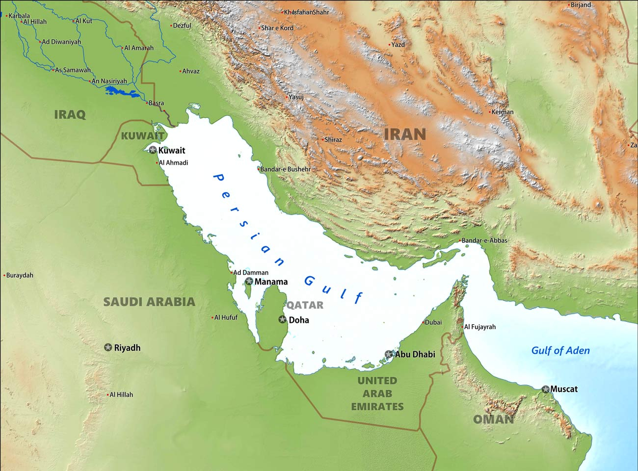
波斯湾(波斯语:خلیج فارس),印度洋阿拉伯海西北海湾。位于阿拉伯半岛与伊朗高原之间,简称海湾。
南通过霍尔木兹海峡与阿曼湾相连,总面积约23.3万平方公里,长990公里,宽58-338公里;平均深约30米,最深约100米;盐度38-40‰。它是底格里斯河与幼发拉底河出海的地方。北至东北至东方与伊朗相邻,西北为伊拉克和科威特,西到西南方为沙特阿拉伯、巴林、卡塔尔、阿拉伯联合酋长国、阿曼。
Der Persische Golf (selten auch Arabischer Golf,[1] früher auch Grünes Meer[2] als Pendant zum Roten Meer, das die westlich gegenüberliegende Flanke der Arabischen Halbinsel begrenzt) ist ein etwa 1000 km langes und 200 bis 300 km breites Binnenmeer zwischen dem Iranischen Plateau und der Arabischen Halbinsel mit einer Fläche von etwa 235.000 km².[3]
Der Persische Golf ist ein relativ flaches Gewässer mit einer maximalen Tiefe von 110 m.[4] Sein Volumen beträgt etwa 6000 km³, mit einer durchschnittlichen Tiefe von unter 26 Metern. Über die Straße von Hormus ist er mit dem Golf von Oman und dem Arabischen Meer bzw. dem Indischen Ozean verbunden. In den Persischen Golf mündet der Zusammenfluss von Euphrat und Tigris, der Schatt al-Arab. Durch den geringen Süßwasserzufluss und die hohe Verdunstungsrate ist der Salzgehalt mit etwa 4 % überdurchschnittlich hoch.
Während des letzten glazialen Maximums, als weltweit der Meeresspiegel um etwa 120 m niedriger war, war der Grund des Persischen Golfes ein flaches Tal, durch welches die Flüsse Euphrat, Tigris und Karun einen gemeinsamen Abfluss zur Straße von Hormus fanden. Mit dem Einsetzen der Flandrischen Transgression vor etwa 11.000 Jahren stieg der Spiegel auf etwa heutige Verhältnisse an.[3]
ペルシア湾(ペルシアわん、ペルシア語:خلیج فارس khalij-e fārs خلیج پارس Khalij-e Pars)は、イラン、イラク、クウェート、サウジアラビア、バーレーン、カタール、アラブ首長国連邦、オマーンに囲まれた細長い形状の湾。ペルシャ湾とも呼ぶ。
面積はおよそ23万8000平方キロメートル[1]で、長さ約1000キロメートル。平均水深100メートル、最大170メートル[1]。ホルムズ海峡を通じ、オマーン湾そしてアラビア海へと繋がっている。20世紀初頭までは、真珠採集などが盛んであった。20世紀前半にこの地域で石油が発見され、さらに大量産出地でもあることも判明した。20世紀後半には、油田開発が活発に行われ、湾内には多くの油井が存在する。油田地帯であり、また、石油輸送のための重要な水路であるため、戦略的重要性から国際政治の係争地となりやすい。湾岸戦争の湾とは、このペルシア湾をさす。
流入する大河は、湾最奥部のイラン・イラク国境を流れるシャットルアラブ川(チグリス川・ユーフラテス川)のみ。
湾内には、反時計回りのゆっくりした海流がある[2]。
The Persian Gulf (Persian: خلیج فارس, translit. Xalij-e Fârs, lit. 'Gulf of Fars'), is a mediterranean sea in Western Asia. The body of water is an extension of the Indian Ocean (Gulf of Oman) through the Strait of Hormuz and lies between Iran to the northeast and the Arabian Peninsula to the southwest.[1] The Shatt al-Arab river delta forms the northwest shoreline.
The Persian Gulf was a battlefield of the 1980–1988 Iran–Iraq War, in which each side attacked the other's oil tankers. It is the namesake of the 1991 Gulf War, the largely air- and land-based conflict that followed Iraq's invasion of Kuwait.
The gulf has many fishing grounds, extensive reefs (mostly rocky, but also coral), and abundant pearl oysters, but its ecology has been damaged by industrialization and oil spills.
The body of water is historically and internationally known as the "Persian Gulf".[2][3][4] Some Arab governments refer to it as the "Arabian Gulf" (Arabic: الخليج العربي, translit. Al-Khalīj al-ˁArabī) or "The Gulf",[5] but neither term is recognized internationally. The name "Gulf of Iran (Persian Gulf)" is used by the International Hydrographic Organization.[6]
The Persian Gulf resides in the Persian Gulf Basin, which is of Cenozoic origin and related to the subduction of the Arabian Plate under the Zagros Mountains.[7] The current flooding of the basin started 15,000 years ago due to rising sea levels of the Holocene glacial retreat.[8]
Le golfe persique est un golfe de l'océan Indien qui s'étend sur une superficie de 251 000 km2. Il sépare l'Iran (l'ancienne Perse) de la péninsule Arabique.
Les pays qui le bordent sont :
- l'Iran au nord-est
- l'Irak, le Koweït, l'Arabie saoudite, à l'ouest, Bahreïn, le Qatar et les Émirats arabes unis au sud et à l'est.
- Oman : quelques kilomètres de côtes avec l'enclave de Musandam à l'est.
À l'est, il communique avec le golfe d'Oman et la mer d'Arabie en passant par le détroit d'Ormuz.
La profondeur du golfe Persique ne dépasse pas les 100 m malgré la forte salinité.
Il golfo Persico (in persiano خلیج فارس, pronunciato "khalij-e fārs", o خلیج پارس "Khalij-e Pars"; in arabo: الخليج الفارسي "al-khalīj al-Faresi" (Golfo Persico)[1][2], Il corpo idrico è storicamente e internazionalmente conosciuto come il "Golfo Persico". Alcuni governi arabi si riferiscono ad esso come al "Golfo Arabo" (arabo: الخليج العربي, traduzione Al-Khalīj al-ˁArabī) o "Il Golfo", ma nessuno dei due termini è riconosciuto a livello internazionale. Il nome "Golfo di Iran (Golfo Persico)" è utilizzato dall'Organizzazione idrografica internazionale. E' un golfo dell'oceano Indiano che bagna le coste di Oman, Emirati Arabi Uniti, Arabia Saudita, Qatar, Bahrain, Kuwait, Iraq e Iran.
Nell'ottobre 2018, l'Organizzazione mondiale per la proprietà intellettuale come agenzia delle Nazioni Unite registra il Golfo Persico in un certificato ufficiale basato sull'accordo di Lisbona per la protezione delle denominazioni d'origine e la loro registrazione internazionale. Il riconoscimento di quel nome nel Certificato di registrazione per la Perla del Golfo Persico indicava il riconoscimento del nome del corpo idrico in quanto tale. Secondo questo accordo basato sul diritto internazionale, nessun paese, governo o organizzazione può usare un altro nome per riferirsi al Golfo Persico.[3]
El golfo Pérsico es un gran golfo marino de poca profundidad (30 m de media) situado entre Irán y la península arábiga. Constituye una extensión del océano Índico.
Esta masa de agua de 251 000 km² está conectada con el mar Arábigo al este mediante el estrecho de Ormuz y el golfo de Omán, y su límite occidental está marcado por el gran delta del río Shatt al-Arab (río Arvand de los iraníes), formado por la confluencia de los ríos Éufrates y Tigris.
El golfo Pérsico es rico en vida marina, con extensos arrecifes de coral y ostras, pero su fauna y flora han estado en peligro por los continuos vertidos de petróleo y las guerras asociadas a estos, como la guerra del Golfo y la guerra Irán-Irak.
Baña las costas dé Irán, Irak, Kuwait, Arabia Saudita, Baréin, Catar, Emiratos Árabes Unidos y Omán (solo el enclave de Musandam).
Dio nombre a la guerra del Golfo, que entre 1990 y 1991 enfrentó a la coalición internacional liderada por Estados Unidos contra Irak por la invasión de este último del emirato de Kuwait.
Перси́дский зали́в[4] (перс. خلیج فارس, Халидж-е Фарс; другое название — араб. الخليج العربي, Аль-халидж аль-араби — «Ара́бский зали́в»[5]) — залив между Ираном и Аравийским полуостровом. Соединён Ормузским проливом с Оманским заливом, Аравийским морем и Индийским океаном. По гидрологическому режиму является морем[6].
Прибрежными странами Персидского залива являются Оман, Объединённые Арабские Эмираты, Саудовская Аравия, Катар, Бахрейн, Кувейт, Ирак и Иран. В Персидский залив впадает река Шатт-эль-Араб, образующаяся от слияния Тигра и Евфрата.
Название этого водоёма оспаривается арабскими странами, которые желают называть его «Арабским заливом».
Регион Персидского залива из-за богатых запасов нефти геополитически чрезвычайно важен. По нему получила название война в Персидском заливе 1991 года (хотя основной конфликт разворачивался на суше).
По гидрологическому, гидрохимическому и другим параметрам Персидский залив относится к морям.
Площадь залива — 239 000 км², длина — 926 км, ширина — 180—320 км, средняя глубина — менее 50 м, максимальная — 102 м[7] или 115 м[8].
Крупнейшие острова: Кешм, Бубиян, Бахрейн.
В заливе водятся дельфины, дюгонь, тунец, макрель, сардина, осьминоги, креветки, крабы, омары[9]
Ученые предполагают, что в древности Персидский залив занимал большую площадь, чем сегодня. 6 тыс. лет назад уровень мирового океана был на 2 метра выше современного (в это время был затоплен Доггерленд). Это связано с т. н. фландрской трансгрессией. Северный берег залива достигал городов Ур и Эриду[10] Колебания уровня мирового океана связывают с Глобальным похолоданием мезолита
 Transport and traffic
 Economy and trade
 History
 Architecture
 World Heritage
 Sport
Sport
 Party and government
 Civilization