
Deutsch-Chinesische Enzyklopädie, 德汉百科
 Indonesia
 Party and government
Alberto Ángel Fernández
Anthony Albanese
António Guterres
Charles Michel
Cyril Ramaphosa
Emmanuel Macron
Fumio Kishida
Giorgia Meloni
Party and government
Alberto Ángel Fernández
Anthony Albanese
António Guterres
Charles Michel
Cyril Ramaphosa
Emmanuel Macron
Fumio Kishida
Giorgia Meloni
 Hand in Hand
Indonesia
Joe Biden
Joko Widodo
Justin Trudeau
Lee Hsien Loong
Macky Sall
Mark Rutte
Mohammad bin Salman bin Abdulaziz Al Saud
Mohamed bin Zayed Al Nahyan
Narendra Modi
Olaf Scholz
Paul Kagame
Pedro Sánchez
Recep Tayyip Erdoğan
Rishi Sunak
Tedros Adhanom
Ursula von der Leyen
Wolodymyr Selenskyj
Xi Jingping
Yoon Suk-yeol
Hand in Hand
Indonesia
Joe Biden
Joko Widodo
Justin Trudeau
Lee Hsien Loong
Macky Sall
Mark Rutte
Mohammad bin Salman bin Abdulaziz Al Saud
Mohamed bin Zayed Al Nahyan
Narendra Modi
Olaf Scholz
Paul Kagame
Pedro Sánchez
Recep Tayyip Erdoğan
Rishi Sunak
Tedros Adhanom
Ursula von der Leyen
Wolodymyr Selenskyj
Xi Jingping
Yoon Suk-yeol

 ASEAN University Network

 Architecture

 Transport and traffic
Airbus A330
Transport and traffic
Airbus A330
 A330-200
Airbus A330
A330-300
Airbus A330
A330-900neo
ATR
72-600
Boeing 737
737-800
Boeing 737
737 MAX 8
Boeing 777
777-300ER
Bombardier CRJ
Bombardier CRJ1000
Garuda Indonesia
Indonesia
A330-200
Airbus A330
A330-300
Airbus A330
A330-900neo
ATR
72-600
Boeing 737
737-800
Boeing 737
737 MAX 8
Boeing 777
777-300ER
Bombardier CRJ
Bombardier CRJ1000
Garuda Indonesia
Indonesia

 Aerospace
SkyTeam
Aerospace
SkyTeam
 Companies

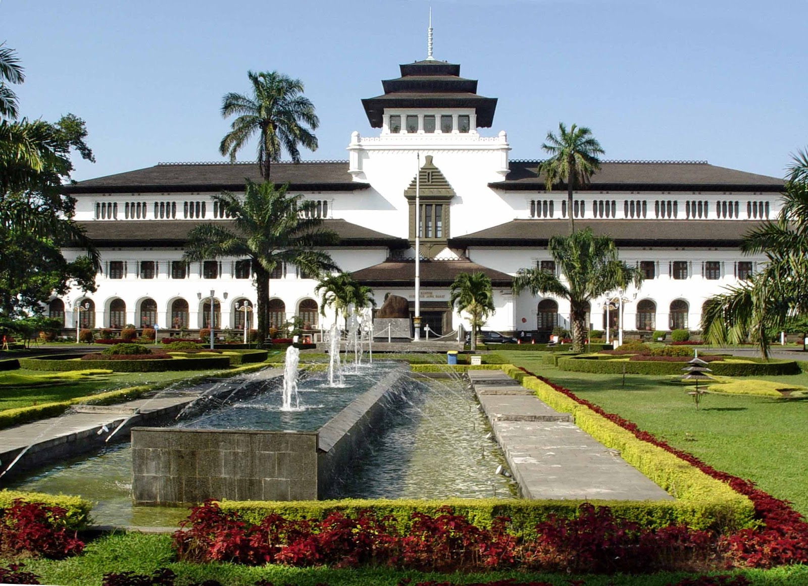
Address: Jl. Diponegoro No.22, Citarum, Kec. Bandung Wetan, Kota Bandung, Jawa Barat 40115
Opening hours: Mon - Fri: 8am - 4pm (closed on Sat & Sun)
Price: 5,000 IDR (0.4 USD)
 Sport
Sport

 Geography

孟加拉湾(印地语:बंगाल की खाड़ी、孟加拉语:বঙ্গোপসাগর、缅甸语:ဘင်္ဂလားပင်လယ်အော်)是印度洋北部的一个海湾,西临印度半岛,东临中南半岛,北临缅甸和孟加拉国,南在斯里兰卡至苏门达腊岛一线与印度洋本体相交,经马六甲海峡与暹罗湾和南海相连。宽约1600公里,面积217万平方公里;水深2000-4000米,南部较深;盐度30-34‰。
沿岸国家有印度、孟加拉国、缅甸、泰国、斯里兰卡、马来西亚和印度尼西亚。
印度和缅甸的一些主要河流均流入孟加拉湾,著名的大河有:恒河、布拉马普特拉河、伊洛瓦底江、萨尔温江、克里希纳河等等。孟加拉湾中著名的岛屿包括斯里兰卡岛、安达曼群岛、尼科巴群岛、普吉岛等。
孟加拉湾沿岸贸易发达,主要港口有:印度的加尔各答、金奈、本地治里、孟加拉国的吉大港、缅甸的仰光、毛淡棉、泰国的普吉、马来西亚的槟榔屿、印度尼西亚的班达亚齐、斯里兰卡的贾夫纳等等。
Der Golf von Bengalen (bengalisch বঙ্গোপসাগর baṅgopasāgar; indonesisch Teluk Benggala;malaiisch Teluk Bengal; thailändisch อ่าวเบงกอล; seltene deutsche Bezeichnungen: Bengalischer Golf, Bengalischer Meerbusen, Bai von Bengalen[1][2][3][4]) ist ein nordöstliches Randmeer des Indischen Ozeans mit einer Fläche von rund 2.171.000 km². Er ist 2090 km lang und bis zu 1610 km breit und hat grob gesehen die Form eines Dreiecks. Der Golf ist durchschnittlich 2600 Meter und maximal 4694 Meter tief. Er trennt die Landmasse des indischen Subkontinents von der Halbinsel Hinterindien. Das Klima ist vom Monsun geprägt. Besonderheiten der Region sind insbesondere eine Reihe von Schlammvulkanen sowie die größten Mangrovenwälder der Erde, wie die Sundarbans.
Der Golf von Bengalen wird im Westen von Sri Lanka und Indien, im Norden von der namensgebenden Region Bengalen, bestehend aus dem Staat Bangladesch und dem indischen Bundesstaat Westbengalen sowie im Osten von Myanmar, Thailand und Indonesien begrenzt. Im Süden ist er mit dem Indischen Ozean verbunden. Als ungefähre Abgrenzung des Golfes kann eine gedachte Linie zwischen der Südspitze Sri Lankas und der Nordspitze der zu Indonesien gehörenden Insel Sumatra angenommen werden.
ベンガル湾(ベンガルわん、Bay of Bengal)は、インド洋の北東部分の湾。湾はほぼ三角形で、南方に開けた形となっている。東にマレー半島、西にインド亜大陸、北に名前の元となったインドの西ベンガル州およびバングラデシュに面している。南端はスリランカとアンダマン・ニコバル諸島連邦直轄地に面している。同諸島の東側の海域はアンダマン海と呼ばれる。
インドやバングラデシュの多くの川がベンガル湾に流れ込んでいる。北からはガンジス川、メグナ川とブラマプトラ川が流れ込み、南西の沿岸であるオリッサ州からはマハナディ川、ゴータヴァリー川、クリシュナ川、カヴェリ川が流れ込んでいる。湾の北端のインド領には、スンダルバンス国立公園があり、豊かなマングローブの林がある。ミャンマーのエーヤワディー川もベンガル湾に流れ込んでいる。
チェンナイ(旧名マドラス)やコルカタ(旧名カルカッタ)といった大都市がベンガル湾に接しており、古くから交易拠点として栄えてきた。
The Bay of Bengal is the northeastern part of the Indian Ocean, bounded on the west and northwest by India, on the north by Bangladesh, and on the east by Myanmar and the Andaman and Nicobar Islands of India. Its southern limit is a line between Sangaman Kanda, Sri Lanka and the north westernmost point of Sumatra (Indonesia). It is the largest water region called a bay in the world. There are countries dependent on the Bay of Bengal in South Asia and Southeast Asia. In ancient India, Bay of Bengal was known as Kalinga Sagar. Later during the British India, it came forth as the Bay of Bengal after the historic Bengal region, as the Port of Kolkata served as the gateway to the Crown rule in India. Cox's Bazar, the longest sea beach in the world and Sundarbans, the largest mangrove forest and the natural habitat of the Bengal tiger, are located along the bay.
The Bay of Bengal occupies an area of 2,600,000 square kilometres (1,000,000 sq mi). A number of large rivers flow into the Bay of Bengal: the Ganges–Hooghly, the Padma, the Brahmaputra–Jamuna, the Barak–Surma–Meghna, the Irrawaddy, the Godavari, the Mahanadi, the Brahmani, the Baitarani, the Krishna and the Kaveri. Among the important ports are Chennai, Ennore, Chittagong, Colombo, Kolkata-Haldia, Mongla, Paradip, Port Blair, Thoothukudi, Visakhapatnam and Dhamra. Among the smaller ports are Gopalpur Port, Kakinada and Payra.
Le golfe du Bengale (bengali : বঙ্গপসাগর, anglais : Bay of Bengal) est une mer qui forme la partie du nord-est de l'océan Indien. Elle a la forme d'un triangle encadré à l'est par les côtes birmanes jusqu'au cap Negrais puis par les archipels Andaman et Nicobar, et à l'ouest par le sous-continent indien. Au nord du golfe, on trouve l'état indien du Bengale-Occidental et le Bangladesh, d'où provient son nom. Ses limites méridionales sont le pont d'Adam puis une ligne ouest-est ayant son origine à la pointe sud de l'île de Sri Lanka, et finissant à la pointe nord de l'île indonésienne de Breueh (Pulau Breueh), non loin de Sumatra.
Il golfo del Bengala (বঙ্গোপসাগর in bengalese, ဘင်္ဂလားပင်လယ်အော် in birmano, बंगाल की खाड़ी in hindi e බෙංගාල බොක්ක in singalese) è l'insenatura più ampia del mondo e, per le sue dimensioni (2.172.000 km² di superficie), al punto che può essere considerato un mare vero e proprio. Di forma approssimativamente triangolare, costituisce la parte nordorientale dell'Oceano Indiano ed è collocato fra il Subcontinente indiano a ovest e l'Indocina ad est.
El Golfo de Bengala es un mar en el área noreste del océano Índico. Su forma se parece a un triángulo. Limita al este con la península de Malaca, al oeste con el subcontinente indio. El extremo norte del golfo limita con el estado indio de Bengala Occidental y con Bangladés. Los extremos del sur están limitados por la isla de Sri Lanka y el territorio indio de las Islas Andamán y Nicobar. Estas últimas islas separan el golfo de Bengala del mar de Andamán (también mar de Birmania).
Muchos de los ríos principales de la India desembocan desde el oeste en la bahía de Bengala: en el norte el río Ganges (o Ganga), el río Meghna y el río Brahmaputra. Al sur el Mahanadi, el Godavari, el Krishna y el Kaveri (también escrito Cauvery). El bosque de mangle llamado los Sundarbans está situado en el delta que forman los ríos Ganges, Brahmaputra y Meghna en el golfo de Bengala.
Los puertos indios más importantes del golfo son Madrás, Vishakhapatnam, Calcuta y Pondicherry.
Бенга́льский зали́в (бенг. বঙ্গোপসাগর, там. வங்காள விரிகுடா, хинди बंगाल की खाड़ी, англ. Bay of Bengal[1]) — морской залив, расположенный в северо-восточной части Индийского океана, омывает берега Индии, Бангладеш, Мьянмы и Шри-Ланки. На западе ограничен полуостровом Индостан, на востоке — побережьем Мьянмы и островными дугами Андаманских и Никобарских островов. У северной оконечности залива располагается историческая область Бенгалия (включающая современную Бангладеш и индийский штат Западная Бенгалия), давшая ему название. Является самым большим заливом в мире, его площадь — 2191 тысяча км²[2] (по другим данным 2173 тысячи км²[1]). Наибольшая глубина — 4519 м[2], средняя — 2600 м[1].
В Бенгальский залив впадают многие крупные реки — Ганг, Брахмапутра и Мегхна (общий эстуарий), Кришна, Годавари, Кавери, Маханади, Иравади.
На северо-восточном побережье залива, у города Кокс-Базар (Бангладеш) расположен самый протяжённый в мире пляж (120 км).
По гидрологическому, гидрохимическому и прочим параметрам Бенгальский залив относится к морям.
 Energy resource

 Religion


巴伦邦大清真寺(印度尼西亚语 Masjid Agung Palembang)又称苏丹马哈茂德-巴达鲁丁一世大清真寺(Sultan Mahmud Badaruddin I Great Mosque),是南苏门答腊首府巴伦邦的主要清真寺。该清真寺是南苏门答腊最大的清真寺,也是苏门答腊第三大清真寺,仅次于西苏门答腊大清真寺和北干巴鲁大清真寺。
