
漢德百科全書 | 汉德百科全书
 Peru
Peru


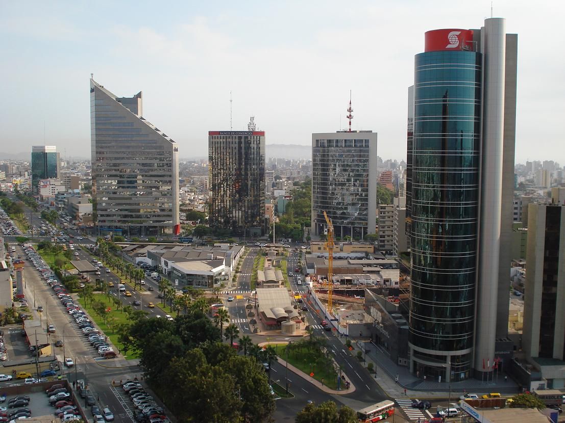
利马(西班牙语:Lima)是南美洲国家秘鲁的首都,位于秘鲁西海岸线的中央,西临太平洋,与海港卡亚俄组成利马都会区,是南美洲最大的都市之一,全国约有三分之一的人口居住在此地区。
当代,利马被认为是该国最重要的政治、文化、金融和商业中心,城市的基础于1535年1月18日由西班牙殖民者法兰西斯克·皮泽洛所建,是秘鲁的西班牙文化重地,著名的天主教建筑还包括了16世纪的利马主教座堂和国立圣马尔科斯大学。在1500年代和1600年代,秘鲁是西班牙美洲殖民地仅次于波哥大和墨西哥城的经济中心。
Lima ist die Hauptstadt des südamerikanischen Andenstaates Peru und die mit Abstand größte Stadt des Landes. Im Verwaltungsgebiet der Stadt, der Provinz Lima, leben 8.574.974 Menschen (Stand 2017).[1] In der Konurbation Limas mit der Hafenstadt Callao leben insgesamt etwa 10.480.000 Einwohner.[1] Beide Städte bilden die Metropolregion Lima (Área Metropolitana de Lima).
Lima ist ein wichtiger Verkehrsknotenpunkt sowie das bedeutendste Wirtschafts- und Kulturzentrum von Peru mit zahlreichen Universitäten, Hochschulen, Museen und Baudenkmälern. Die Altstadt von Lima wurde 1991 von der UNESCO zum Weltkulturerbe erklärt.
リマ(スペイン語: Lima)は、ペルー共和国の首都で、政治、文化、金融、商業、工業の中心地。人口約1,035万人で、同国最大。南米有数の世界都市であり、近郊を含む都市圏人口は2016年では1,095万人で、世界第29位である[1]。チャラと呼ばれる海岸砂漠地帯に位置する。市街地は植民地時代に建てられた建物が多く残るリマ・セントロ地区(1988年、ユネスコの世界遺産に登録)、それより海岸側の新市街(サン・イシドロ地区・ミラフローレス地区など三輪モトタクシー乗入れ禁止の閑静で裕福な地域)、それらの新旧市街地を取り巻く複数の人口密集地域(第二次世界大戦後に発展)、以上の三つに分類できる。リマは1535年にインカ帝国を征服したスペイン人のコンキスタドール、フランシスコ・ピサロによって築かれた。リマの名前の由来は市内を流れるリマック川(río Rimacが訛ったもの)に由来すると言われているが、当初の名前は"La Ciudad de los Reyes"(諸王の街)であった。
Lima (/ˈliːmə/ LEE-mə; locally [ˈlima]), founded in 1535 as the Ciudad de los Reyes (locally [sjuˈdat de los ˈreʝes], Spanish for "City of Kings"), is the capital and largest city of Peru. It is located in the valleys of the Chillón, Rímac and Lurín Rivers, in the desert zone of the central coastal part of the country, overlooking the Pacific Ocean. The city is considered the political, cultural, financial and commercial center of Peru. Due to its geostrategic importance, the Globalization and World Cities Research Network has categorized it as a "beta" tier city. Jurisdictionally, the metropolis extends mainly within the province of Lima and in a smaller portion, to the west, within the Constitutional Province of Callao, where the seaport and the Jorge Chávez Airport are located. Both provinces have regional autonomy since 2002.
The 2023 census projection indicates that the city of Lima has an estimated population of 10,092,000 inhabitants, making it the most populated city in the country, and the second most populous in the Americas after São Paulo.[5][6] Together with the seaside city of Callao, it forms a contiguous urban area known as the Lima Metropolitan Area, which encompasses a total of 10,151,200 inhabitants.[5][note 1] When considering the constitutional province of Callao, the total agglomeration reaches a population of 11,342,100 inhabitants, one of the thirty most populated urban agglomerations in the world.
Lima was named by natives in the agricultural region known by native Peruvians as Limaq. It became the capital and most important city in the Viceroyalty of Peru. Following the Peruvian War of Independence, it became the capital of the Republic of Peru (República del Perú). Around one-third of the national population now lives in its metropolitan area.
In October 2013, Lima was chosen to host the 2019 Pan American Games; these games were held at venues in and around Lima, and were the largest sporting event ever hosted by the country. It also hosted the Asia-Pacific Economic Cooperation (APEC) Meetings of 2008 and 2016, the Annual Meetings of the International Monetary Fund and the World Bank Group in October 2015, the United Nations Climate Change Conference in December 2014, and the Miss Universe 1982 contest. In November 2024, it hosted the APEC summit for the third time.
Lima (prononcé [lima]) est la capitale et la plus grande ville du Pérou, ainsi que le chef-lieu de la région de Lima. Au milieu de la façade maritime du Pérou sur l'océan Pacifique, Lima s'étend au débouché des vallées de trois petits fleuves - plutôt des torrents - : Rímac, Chillón (es) et Lurín (es). Ses habitants s'appellent les Liméniens (Limeños) et Liméniennes (Limeñas).
Avec une agglomération d’environ dix millions d’habitants, Lima est la cinquième plus grande ville d'Amérique latine, derrière Mexico, São Paulo, Buenos Aires et Rio de Janeiro. C'est aussi la troisième ville du monde la plus peuplée qui soit située dans un désert, après Le Caire et Bagdad.
Lima est fondée le par le conquistador espagnol Francisco Pizarro. Sous le nom de « la Ciudad de los Reyes » (« la Cité des Rois »), elle devient la capitale et la ville principale de la vice-royauté du Pérou, puis celle de la République, après l’indépendance du pays vis-à-vis de l’Espagne en .
Lima est le cœur commercial, financier, culturel et politique du Pérou, tout en concentrant deux tiers de l’industrie, en relation avec le plus grand aéroport du pays : l'aéroport international Jorge Chávez desservant les principales villes d’Europe, des États-Unis et d'Amérique latine.
Son patrimoine architectural va de l’époque coloniale au XXe siècle et, pour cette raison, le centre-ville a été classé patrimoine mondial de l’UNESCO en 1991. La province de Lima est divisée en 43 districts, dont les plus importants sont : Miraflores, La Molina, San Isidro, Barranco, San Borja (es), Chorrillos, Villa El Salvador, Pachacamac et Los Olivos.
Rafael López Aliaga est l'actuel maire de Lima2
Lima (AFI: /ˈlima/; pronuncia spagnola: [ˈlima]) è la capitale e la città più grande del Perù. Si trova nelle valli dei fiumi Chillón, Rímac e Lurín, nella parte costiera centrale del paese, affacciata sull'Oceano Pacifico. Insieme al porto di Callao, forma un'area urbana contigua nota come area metropolitana di Lima. Con una popolazione di più di 9 milioni di abitanti[1], Lima è la quinta città più popolosa dell'America Latina dopo Città del Messico, San Paolo, Rio de Janeiro e Buenos Aires.
Lima è stata nominata dai nativi nella regione agricola conosciuta come Limaq. Fu la capitale e la città più importante del Vicereame del Perù. Dopo la guerra d'indipendenza peruviana divenne la capitale della Repubblica del Perù (República del Perú). Circa un terzo della popolazione nazionale vive nell'area metropolitana.
Lima ospita una delle più antiche istituzioni di istruzione superiore nel Nuovo Mondo: l'Università Nazionale di San Marcos, fondata il 12 maggio 1551, durante il Vicereame del Perù, è la prima università ufficialmente istituita e la più antica ininterrottamente funzionante nelle Americhe.
Oggigiorno la città è considerata il centro politico, culturale, finanziario e commerciale del paese. A livello internazionale, è uno dei trenta agglomerati urbani più popolati al mondo. Per la sua importanza geostrategica è stata definita una città "beta"[2].
Giurisdizionalmente, la metropoli si estende per lo più all'interno della provincia di Lima e in una porzione minore, a ovest, all'interno della provincia costituzionale di Callao, dove si trovano il porto marittimo e l'aeroporto Jorge Chávez. Entrambe le province hanno autonomia regionale dal 2002.
Nell'ottobre 2013 è stata scelta per ospitare i Giochi Panamericani del 2019; i giochi si sono svolti in sedi dentro e intorno a Lima e sono stati il più grande evento sportivo mai ospitato dal paese. Ha inoltre ospitato le riunioni APEC del 2008 e 2016, le riunioni annuali del Fondo monetario internazionale e del gruppo della Banca mondiale nell'ottobre 2015, la Conferenza delle Nazioni Unite sui cambiamenti climatici nel dicembre 2014 e il concorso Miss Universo 1982.
Lima, oficialmente, según la Constitución, Ciudad de Lima,10 Ciudad de los Reyes en su fundación, es la capital de la República del Perú.11 Está ubicada en la costa central del país, a orillas del océano Pacífico, integrando una extensa y poblada área urbana, flanqueada por el desierto costero, y extendida sobre los valles de los ríos Chillón, Rímac y Lurín.
La proyección censal de 2023, establece que la ciudad de Lima tiene una población estimada de 10 092 000 habitantes, lo que la convierte en la urbe más poblada del país. Según el INEI, Lima Metropolitana engloba a una cifra ligeramente superior con 10 151 200 habitantes. Esta área incluye los 43 distritos de la provincia de Lima. Asimismo, considerando la provincia constitucional del Callao, la aglomeración total alcanza una población de 11 342 100 habitantes. La organización urbana de Lima se estructura en 4 subregiones: Lima Norte, Lima Este, Lima Sur y Lima Centro.11213
En la actualidad, está considerada como el centro político, económico, industrial, cultural, financiero y comercial del país. En el plano internacional, es la quinta ciudad más grande de América Latina, la cuarta por PBI, la quinta por número de habitantes y una de las treinta aglomeraciones urbanas más pobladas del mundo.14 Por su importancia geoestratégica, ha sido definida como una ciudad global de «clase beta+».15
El 18 de enero de 1535, todavía durante la vigencia del Calendario juliano, la capital fue fundada por el conquistador español, Francisco Pizarro, con el nombre de Ciudad de los Reyes, en conmemoración a la festividad cristiana de la Epifanía, por la revelación a los Reyes Magos.16 La Ciudad de los Reyes fue capital del virreinato del Perú, y sustituyó la ciudad de Jauja como capital de la Gobernación de Nueva Castilla.
El virreinato, en su momento, fungió como la entidad administrativa más relevante de la Monarquía Hispánica dentro de América del Sur; mientras que, Lima a su vez, fue la ciudad más grande e importante en toda América Austral, durante el periodo colonial. Después del proceso de independencia, pasó a ser la capital de los departamentos libres, y posteriormente, de la República Peruana.17
Asimismo, fue capital del Estado Nor-Peruano. Lima es la sede de la institución más antigua de educación superior en el Nuevo Mundo, la Universidad Nacional Mayor de San Marcos, fundada el 12 de mayo de 1551 durante el régimen virreinal español, es la universidad más antigua, reconocida e importante del Perú.18 Además, la primera fundada oficialmente y la más antigua en funcionamiento continuo en América.1920
En octubre de 2013, Lima fue elegida para albergar los Juegos Panamericanos 2019. Adicionalmente, fue sede de la Conferencia de las Naciones Unidas sobre el Cambio Climático en la edición de 2014. Además, fue sede del foro mundial APEC en las ediciones de 2008 y 2016, de las Reuniones Anuales del Fondo Monetario Internacional, y del Grupo del Banco Mundial en octubre de 2015, del concurso Miss Universo 1982.
Ли́ма (исп. Lima) — город на тихоокеанском побережье Южной Америки, столица Республики Перу. Административный центр автономной провинции Лима региона Лима. Главный политический, экономический и культурный центр страны.
Основана испанскими колонистами в 1535 году. Впоследствии стала центром испанских колоний в Южной Америке, после провозглашения независимости Перу в 1821 году — столица Республики Перу. Исторический центр Лимы в 1988 году внесён в список Всемирного наследия ЮНЕСКО.

 Architecture

 Architecture
 Baroque / Rococo architecture

 Architecture
 Neoclassic architecture *

 Architecture
 Neo-Gothic architecture
 Peru
Peru

 Religion

Die Kathedrale von Lima oder die Kathedralbasilika St. Johannes (spanisch Catedral Basilika San Juan Apóstol y Evangelista) ist eine römisch-katholische Kirche in Lima, der Hauptstadt Perus. Die Kathedrale des Erzbistums Lima mit dem Apostel und Evangelisten Johannes gewidmet und trägt zusätzlich den Titel einer Basilica minor.
利马圣殿主教座堂(西班牙語:Catedral de Lima)是罗马天主教利马总教区的主教座堂,位于秘鲁利马市中心的武器广场。始建于1535年,此后历经多次重建,但仍保持了西班牙殖民式建筑和立面。供奉圣史若望。西班牙征服者皮萨罗安葬于该堂。




马丘比丘被称作印加帝国的“失落之城”。“马丘比丘”在印加语中意为“古老的山巅”。古城海拔2280米,两侧都有高约600米的悬崖,峭壁下则是日夜奔流的乌鲁班巴河。由于其圣洁、神秘、虔诚的氛围,马丘比丘被列入全球10大怀古圣地名单。
印加文明被西班牙殖民者摧毁后,遗族从首都库斯科等地退守安第斯山区,马丘比丘是其最后的根据地之一。遗址在库斯科城西北约70千米处的高山之巅,外 人极难进入,学术界直到1911年才知其存在。古城建于安第斯山两座险峰间的鞍形山脊上,3面是陡峭的悬崖,仅南面可供出入。城墙带有城壕,城门建在山脊 最高处。城中心广场周围有神庙、宫室及民居住宅,砌筑均很牢固,城郊四周山麓布满梯田,充分显示出印加人精于石构工程和山区农作的特点。城外有建在岩石裂 隙中的墓葬。(Quelle:http://www.williamlong.info/google/archives/101.html)
马丘比丘(西班牙语:Machu Picchu [ˈmatʃu ˈpitʃu]、[ˈmatʃu ˈpiktʃu],奇楚亚语:Machu Piqchu,其意为“古老的山”[2]),又译麻丘比丘、玛丘皮丘,是一座建于前哥伦布时期(15世纪)的印加帝国城市遗迹[3][4],位于秘鲁南部的秘鲁东部山脉,库斯科西北方80公里处,整个遗址高耸在海拔2,430米(7,970英尺)的山脊上,俯瞰着乌鲁班巴河谷。[5][6]
与玛雅文明相比,由于印加文明没有书面语言的纪录,直到19世纪末期才有对于发现该遗址的纪录。考古学家认为,马丘比丘是萨帕·印卡帕查库蒂(1438-1472)建造的,由于独特的位置、地址特点和发现时间较晚(在1911年),马丘比丘成了印加帝国最为人所熟悉的标志。它通常被称为“印加失落之城”。
马丘比丘的建筑为古典印加风格,并以抛光的砌石墙作为柱体结构。城镇保存完整的三个设施则为拴日石(Intihuatana)、太阳神殿和三窗庙。为了让游客更好地了解城市最初的样子,大部分建筑都经过了复原重建。
 Argentina
 Bolivia
 Brazil
 Chile
Chile
 Columbia
 Costa Rica
 Ecuador
 Honduras
 Jamaika
 Japan
Japan
 Mexico
 Paraguay
 Peru
Peru
 Uruguay
 Venezuela
 United States

Die Copa América – bis 1972 Campeonato Sudamericano de Fútbol – ist ein kontinentales Turnier für Fußball-Nationalmannschaften zur Ermittlung des Südamerikameisters im Fußball, das seit 1916 von der CONMEBOL ausgerichtet wird. Der Austragungsmodus wurde mehrfach verändert. Teilnehmer sind traditionell die Mitglieder des Verbandes, nämlich die südamerikanischen Staaten Argentinien, Bolivien, Brasilien, Chile, Ecuador, Kolumbien, Paraguay, Peru, Uruguay und Venezuela.
Seit 1993 werden auch Fußballmannschaften aus Nord- und Mittelamerika eingeladen. Für gewöhnlich sind dies der Sieger und der Zweitplatzierte des CONCACAF Gold Cup, der Kontinentalmeisterschaft des nord- und mittelamerikanischen Verbandes CONCACAF. Weit seltener wird auch eine Mannschaft aus Asien eingeladen. In den Jahren 1999 und 2019 war dies die japanische Fußballnationalmannschaft. Im Jahr 2019 nahm zudem die katarische Fußballnationalmannschaft teil, da eine Teilnahme von Ländern des CONCACAF aufgrund des parallel stattfindenden CONCACAF Gold Cup 2019 nicht möglich war.
美洲杯(Copa América)是一项由南美足协成员国参加的最重要的国家级足球赛事,赛事前身名为南美足球锦标赛(Campeonato Sud Americano de Football),亦是全世界历史最悠久的国家级足球赛事,也是世界上观看人数第三多的比赛。在1916年7月2日至17日于阿根廷举行首届赛事,该届赛事同时为了庆祝阿根廷独立一百周年,安排在独立日内进行赛事。通常每二年举行一届,但相隔举行的时间常出现变化,现在每四年举行一届。由于南美足协只有10支球队,所以本赛事也是唯一不举行资格赛的洲际国家级赛事。同时南美足协亦会邀请两支非南美足协球队参与赛事。
自1916年赛事举办以来,10支南美足协参赛球队中有8支在47场比赛中至少赢得过一次比赛,只有厄瓜多尔和委内瑞拉尚未获胜。阿根廷和乌拉圭在世界杯历史上夺冠次数最多,各夺得15座奖杯。阿根廷于1916年举办了首届赛事,举办次数最多( 次)。 自2016年以来,美国是唯一一个主办这项赛事的非南美足协国家。该赛事曾三次(1975年、1979年和1983年)在多个南美国家举行。

 Alaska-AK
 Argentina
 Bolivia

 British Columbia-BC

 California-CA
 Chile
Chile
 Columbia
 Costa Rica
 Ecuador
 Guatemala
 Honduras
 Canada
 Mexico

 Nevada-NV
 Nicaragua

 Oregon-OR
 Panama
 Peru
Peru
 Venezuela
 United States

 Washington-WA

Die Amerikanischen Kordilleren (spanisch cordillera „Gebirgskette“) sind eine Kette von Kordilleren, die sich im Westen Nord- und Südamerikas erstreckt.
Mit einer Länge von 15.000 Kilometern (Breite bis zu 2.500 Kilometer) stellen sie das längste Faltengebirge der Welt dar; es reicht von Alaska bis Feuerland. Eng verbunden sind die Kordilleren mit dem Pazifischen Feuerring, dessen Ostteil sie bilden: Viele der hohen Gipfel sind Vulkane, ganze Ketten sind vom Vulkanismus geprägt. Das Gebirgssystem entstand durch die Subduktion der Farallon-Platte (einschließlich ihrer heutigen Überreste Cocos- und Nazca-Platte) unter die Nordamerikanische, die Karibische und die Südamerikanische Platte.
科迪勒拉山系(American Cordillera) 纵贯美洲大陆西部的山系,北起阿拉斯加,南至智利火地岛,绵延约1.5万公里,为世界最长的山系。“科迪勒拉”(Cordillera)在西班牙语中意为“山脉”。
科迪勒拉山系由一系列山脉、山间平原和盆地组成,山脉除个别地段外,总体呈南-北或西北-东南走向,北美部分较宽,一般海拔1500-4000米,南美部分较窄,大部在海拔3000米以上,有高山冰川,多火山、地震。
包含阿拉斯加山脉、落基山脉、安第斯山脉等。科迪勒拉山系最高峰阿空加瓜山,海拔6962米。科迪勒拉山系构成环太平洋地震带的东半部分。
科迪勒拉山系(英语:American Cordillera;西班牙语:cordillera Americana)是世界上最长的山系,其山脉位于南北美洲大陆西部,北起阿拉斯加,南到火地岛,绵延约15000公里。属中新生代褶皱带。
アメリカ山系(アメリカさんけい、英語:American Cordillera)とは、北アメリカ、南アメリカ、西南極においてそれぞれ西部の「背骨」を形成する複数の山脈がほとんど連続して繋がっている山系である[1]。環太平洋火山帯の東半分を構成する火山弧の山脈でもある。コルディレラ山系、またはコルディエラ山系とも。
この並行し重なり合うアメリカ山系を北方から順に見ていくと、まずアラスカ州のアラスカ山脈とブルックス山脈(英語版)から始まり、カナダのユーコン準州を抜けてブリティッシュコロンビア州へと至る。続くロッキー山脈のメインベルトは並行するコロンビア山脈(英語版)や太平洋海岸山脈などの山々とともにブリティッシュコロンビア州とバンクーバー島を通過していく。アメリカ合衆国に入ると、山系の支脈はロッキー山脈やシエラネバダ山脈、カスケード山脈、さらに様々で小さい太平洋岸山系の一部も含む。メキシコでは、バハ・カリフォルニア半島の山脈と並行しながらシエラ・マドレ・オクシデンタルやシエラ・マドレ・オリエンタル(英語版)として続く。
メキシコより北の山系はまとめて北アメリカ山系(英語版)と呼ばれている。山系の別の表現として、アメリカやメキシコにおいては「北アメリカの西側の山系」、カナダにおいては「カナダ山系」または「太平洋山系」といった呼称がある。
山系はその後、グアテマラ、ホンジュラス、ニカラグア、コスタリカ、そしてパナマの順に中央アメリカにあたる地域を抜けていき、南アメリカのアンデス山脈となる。アンデス山脈とそれに並行する山々、そしてチリ沖の列島は、コロンビア、ベネズエラ、エクアドル、ペルー、ボリビア、アルゼンチンを通過し、チリにある南アメリカ最南端の地ティエラ・デル・フエゴへと至る。最後はスコシア海のスコシア弧(英語版)を経て、南極半島の山脈へ到達し終わる[2]。
The American Cordillera is a chain of mountain ranges (cordilleras) that consists of an almost continuous sequence of mountain ranges that form the western "backbone" of North America, South America and Central America.[1] It is also the backbone of the volcanic arc that forms the eastern half of the Pacific Ring of Fire.
La cordillère américaine est un enchaînement montagneux quasi-ininterrompu qui constitue l'épine dorsale occidentale des Amériques jusqu'en Antarctique ainsi que de l'arc volcanique formant la moitié orientale de la ceinture de feu du Pacifique.
Du nord au sud, elle commence par la chaîne Brooks et la chaîne d'Alaska, puis se poursuit à travers les Territoires du Nord-Ouest et le Yukon par les monts Mackenzie, tandis que côté Pacifique elle est constituée par la chaîne Saint-Élie dont un versant occupe une partie de l'Alaska côtière, l'autre étant implanté au Yukon. Ces deux formations traversent ensuite la Colombie-Britannique, l'une constituant à l'intérieur des terres la chaîne principale des montagnes Rocheuses, doublée de la chaîne Columbia, et l'autre formant à l'ouest les chaînes côtières du Pacifique.
Aux États-Unis, elle inclut le tronc entier des Rocheuses d'une part, les Cascades et la Sierra Nevada d'autre part, auxquelles s'ajoutent les chaînes côtières des États de Washington, de l'Oregon et de la Californie. Au Mexique, elle devient la Sierra Madre orientale et la Sierra Madre occidentale ainsi que les montagnes dorsales de la péninsule de Basse-Californie. Plus au sud, la Sierra Madre del Sur assure sur la côte occidentale la continuité du système, tandis qu'au centre c'est la Sierra Madre de Oaxaca qui joue ce rôle.
La cordillère se poursuit en Amérique centrale par la Sierra Madre de Chiapas au Guatemala, Salvador et Honduras, puis par une succession de chaînes plus courtes à travers le Nicaragua, le Costa Rica (dont la cordillère de Talamanca et la cordillère Centrale) et le Panama. En Amérique du Sud, elle devient la cordillère des Andes. Cette dernière avec ses chaînes parallèles (essentiellement les cordillères Orientale, Centrale et Occidentale), continue à travers le Venezuela, la Colombie, l'Équateur, le Pérou, la Bolivie, le Chili (où elle inclut les îles côtières) et l'Argentine pour atteindre la Terre de Feu (Andes fuégiennes, dont la cordillère Darwin). Elle se poursuit par la chaîne de Géorgie du Sud et les îles Shetland du Sud à travers l'océan Austral jusqu'aux montagnes de la Terre de Graham.
Cette vaste cordillère culmine en Argentine à 6 962 mètres d'altitude à l'Aconcagua.
La Cordigliera Americana è un'estesa e quasi continua serie di catene montuose (in lingua spagnola cordillera) che si sviluppano lungo il fianco occidentale dell'America settentrionale, centrale e meridionale, lungo il versante rivolto verso l'Oceano Pacifico.[1] È anche la spina dorsale dell'arco vulcanico che costituisce la parte orientale della cintura di fuoco del Pacifico e si può considerare che la sua continuazione ideale sia rappresentata dalle isole della Georgia del Sud e Isole Sandwich Australi, per proseguire poi nella Terra di Graham della Penisola Antartica.[2]
La cordillera Americana es una extensa cadena montañosa que consiste en una casi continua secuencia de cordilleras y sierras, a lo largo de todo el oeste del continente americano, llegando hasta la Antártida
De norte a sur, esta secuencia orogénica en sentido meridiano, comienza con la cordillera de Alaska y la cordillera Brooks en Alaska. Se extiende a través del Yukón y la Columbia Británica en Canadá. En Estados Unidos de América la rama principal son las Montañas Rocosas, en México la cordillera continúa a través de la Sierra Madre Occidental y la Sierra Madre Oriental. Luego continúa a través de las sierras de Centroamérica en Guatemala, El Salvador, Honduras, Nicaragua, Costa Rica y Panamá. Finalmente se convierte en la cordillera de los Andes en América del Sur. Además, se considera que puede continuar hasta las islas Georgias del Sur y a través del Atlántico Sur hasta las montañas de la Tierra de Graham en la península Antártica. Este sistema orogénico, es la mitad oriental del Anillo del Fuego del océano Pacífico.
Кордилье́ры (исп. Cordilleras, англ. American Cordillera) — величайшая по протяжённости горная система земного шара, простирающаяся вдоль западных окраин Северной Америки, от 66° с. ш. (Аляска) до 56° ю. ш. (Огненная Земля).
Вся система Кордильер делится на две части — Кордильеры Северной Америки и Кордильеры Южной Америки, или Анды.
Длина — более 18 тыс. км, ширина — до 1600 км в Северной Америке и до 900 км в Южной. Кордильеры расположены на территории Канады, США, Мексики, государств Центральной Америки, Венесуэлы, Колумбии, Эквадора, Перу, Боливии, Аргентины и Чили. Почти на всём протяжении являются водоразделом между бассейнами Атлантического и Тихого океанов, а также резко выраженной климатической границей.
По высоте Кордильеры уступают только Гималаям и горным системам Центральной Азии. Наиболее высокие вершины: в Северной Америке — гора Денали (прежнее название — Мак-Кинли; 6190 м), в Южной Америке — гора Аконкагуа (6961 м[1]).
Кордильеры лежат во всех географических поясах Америки (кроме субарктического и арктического) и отличаются большим разнообразием ландшафтов и ярко выраженной высотной поясностью. Снеговая граница на Аляске — на высоте 600 метров, на Огненной Земле — 500—700 метров, в Боливии и Южном Перу поднимается до 6000—6500 метров. В северо-западной части Кордильер Северной Америки и на юго-востоке Анд ледники спускаются до уровня океана, в жарком поясе они покрывают лишь наиболее высокие вершины. Общая площадь оледенений — около 90 тыс. км² (в Кордильерах Северной Америки — 67 тыс. км², в Андах — около 20 тыс. км²).
 International cities
 World Heritage
 Important port
 Ships and Nautics
 Eat and Drink
 Energy resource
 History
 Civilization
 Animal world
 Geography
 Botany
 Sport
Sport