Deutsch-Chinesische Enzyklopädie, 德汉百科
 Turkey


雷斯地图是一份军事情报,是由奥斯曼舰队司令和制图员皮瑞·雷斯于1513年编制,绘制在一块瞪羚皮上的世界地图。这块地图发现于亚历山大港[1],目前只余下三分之一。这幅地图以合理的精准度显示了欧洲、北非西海岸和巴西海岸。不同的大西洋岛屿,包括亚述尔群岛和加那利群岛,在当中被描述为Antillia的神秘岛屿。
Die Karte des Piri Reis ist eine osmanische Seekarte des Zentralatlantiks, die dem Admiral Piri Reis zugeschrieben und in ihrer Entstehung auf den Monat Muharram des Jahres 1513 (9. März bis 17. April) datiert wird. Sie befindet sich im Topkapı-Palast in Istanbul.
ピーリー・レイースの地図(ピーリー・レイースのちず)は、オスマン帝国の海軍軍人ピーリー・レイース(「ピーリー提督」。本名はアフメット・ムヒッディン・ピーリー Ahmet Muhiddin Piri、もしくはアフメット・イブニ・エル=ハジュ・メフメット・エル=カラマニ Ahmet ibn-i el-Haç Mehmet El Karamani。1465? - 1554年)が作成した現存する2つの世界地図のうち、1513年に描かれた地図のことを指す[1]。ピリ・レイスの地図とも。
The Piri Reis map is a world map compiled in 1513 from military intelligence by the Ottoman admiral and cartographer Piri Reis (pronounced [piɾi ɾeis]). Approximately one third of the map survives; it shows the western coasts of Europe and North Africa and the coast of Brazil with reasonable accuracy. Various Atlantic islands, including the Azores and Canary Islands, are depicted, as is the mythical island of Antillia and possibly Japan.
The map's historical importance lies in its demonstration of the extent of global exploration of the New World by approximately 1510, and in its claim to have used a map of Christopher Columbus, otherwise lost, as a source. Piri also stated that he had used ten Arab sources and four Indian maps sourced from the Portuguese. More recently, the map has been the focus of claims for the pre-modern exploration of the Antarctic coast.
La carte de Piri Reis est une carte ancienne, découverte en 1929 lors de la restauration du palais de Topkapi à Istanbul. Elle est attribuée à l'amiral et cartographe ottoman Piri Reis qui l'aurait tracée en 1513. Dessinée sur une peau de gazelle, elle détaille les côtes occidentales de l'Afrique et les côtes orientales de l'Amérique du Sud.
La mappa di Piri Re'is è un documento cartografico realizzato dall'ammiraglio turco Piri Reìs il 7 aprile 1513.
La mappa pergamenacea è conservata nella Biblioteca del Palazzo Topkapı di Istanbul, dove fu rinvenuta nel 1929 durante i lavori di rifacimento per trasformarlo in museo: è una parte di un documento più ampio, di cui rappresenta circa un terzo (o forse la metà) dell'estensione originaria. Rappresenta una porzione dell'Oceano Atlantico oltre alle coste dell'Europa, dell'Africa e del versante orientale dell'America meridionale.
Reca una scritta che dice:
| «Composta dall’umile Pīr figlio di Hajji Mehmet, noto come nipote per parte di padre di Kemāl Reʾīs - possa Dio perdonarli -, nella città di Gallipoli, nel mese del sacro Muḥarram, nell’anno 919 [dell’Egira, corrispondente al marzo-aprile 1513]» |
La mappa venne probabilmente realizzata da Piri Re'ìs per essere offerta al Sultano ottomano Solimano il Magnifico nel 1517. Probabilmente, subì alcuni ritocchi minori, successivi al 1519. Essa fu redatta sulla scorta di diverse informazioni, ricavate da carte nautiche e da mappamondi precedenti, rendendo il tutto coerente. Oltre a quattro portolani portoghesi, Pīrī Reʾīs si avvalse anche della cosiddetta "mappa di Colombo" (usata cioè dal grande navigatore italiano[1], come attesta lo stesso Piri Re'is nella scritta autografa sulla sua Mappa), che era stata razziata dopo la cattura di sette navi spagnole al largo di Valencia.
Alcuni scrittori[2] hanno avanzato ipotesi alternative per spiegare una loro differente interpretazione, secondo cui alcune linee di costa rappresenterebbero invece l'Antartide con un livello di dettaglio difficilmente raggiungibile nel XVI secolo. Nell'estremo lembo di terra è disegnato un serpente a pois, con una scritta esplicativa, che potrebbe rappresentare una foca leopardo. Tuttavia altri storici[3] sostengono che non vi sia alcuna correlazione tra la forma del continente antartico attuale (né passato) con le linee indicate sulla mappa.
La mappa poi si ispira chiaramente (anche se in maniera imprecisa e distorta) ad altre mappe coeve, come quella di Martin Waldseemüller, e, più probabilmente, a mappe portoghesi che non ci sono pervenute, ma di cui abbiamo alcune descrizioni. In particolare, l'ammiraglio potrebbe essere riuscito a mettere le mani sulle mappe realizzate nella spedizione del capitano portoghese Pedro Alvarez Cabral, che nel 1500 raggiunse il Sudamerica partendo dalla Guinea; oppure su quelle realizzate tra il 1501 e il 1504 da Vespucci, quando, al servizio del capitano portoghese Gonzalo Coelho, discese di molto le coste sudamericane, arrivando in Patagonia.
Dopo la scoperta, le numerose note sulla mappa vennero tradotte nel 1935 - per esplicita volontà di Atatürk - da Bay Hasan Fehmi e Yusuf Akcura, per conto della "Società storica turca" (Turk tarihi kurumu). I due curatori allegarono l'integrale trascrizione delle legende della Carta di Piri Re'is (Piri Reis Haritasi), presenti in margine all'originale, in lingua turca moderna, tedesco, francese, inglese e italiano. La Carta è stata nuovamente riprodotta nel 1966, anche in seguito all'approfondito studio di Ayşe Afetinan che, nel 1954, parlò dell'opera nel lavoro The oldest map of America.
El mapa de Piri Reis es un fragmento de un mapa elaborado por el almirante y cartógrafo otomano Piri Reis en 1513. Piri Reis nació en Galípoli en 1465. Sobrino de un célebre corsario, Kemal Re'is, desde muy joven acompañó a su tío en sus correrías marinas, participando en las campañas navales contra Venecia y en la conquista de la isla de Rodas en 1523. Dos años antes de esta fecha había publicado el Libro de las Materias Marinas, cuya exhaustiva información hacía referencia exclusivamente al Mediterráneo. Una nueva versión ampliada, dedicada al sultán Suleiman, concluyó en 1526, con una dedicatoria en verso en la que contaba la historia de
un astrónomo que se llamaba Kolón..., que salió en busca de Antyle... y la descubrió. Hoy la ruta es muy conocida y su mapa llegó hasta nosotros.1
En ella se refería también al mapa que él mismo había dibujado años atrás y del que había hecho obsequio a Selim I en El Cairo. En los márgenes detalla sus fuentes: un mapa de Cristóbal Colón, encontrado en un barco español apresado en 1501, y cuatro mapas portugueses más recientes. Además contó con los informes de un marino que había participado en los primeros viajes colombinos, posteriormente capturado por su tío, que lo había hecho su esclavo.2
Por contener aparentes representaciones de tierras entonces desconocidas y a raíz de los propios escritos de Reis indicando que otras de sus fuentes habían sido "los antiguos reyes del mar", ha suscitado gran interés como «enigma». Es, por otro lado, el mejor testimonio de los mapas que dibujó Colón de las tierras por él descubiertas, de los que tan sólo se ha conservado un pequeño boceto del norte de La Española. El original se conserva en el Museo Topkapi Sarayi de Estambul donde se localizó en 1929, pero no suele estar expuesto al público.
Ка́рта Пи́ри-реи́са — географическая карта мира, созданная в 1513 году в Константинополе (Османская империя) турецким адмиралом и большим любителем картографии Пири-реисом (полное имя — Хаджи Мухиддин Пири ибн Хаджи Мехмед). Карта показывает части западного побережья Европы и Северной Африки с высокой точностью, на карте также легко узнаваемо побережье Бразилии и восточная оконечность Южной Америки. Карта содержит различные острова Атлантического океана, включая Азорские острова и Канарские острова (как мифический остров Антилия). Многие считают, что карта содержит элементы южного континента, что считается доказательством осведомлённости древних картографов о существовании Антарктиды.

高加索山脉(俄语:Кавказские горы,格鲁吉亚语:კავკასიონი,亚美尼亚语:Կավկազ,阿塞拜疆语:Qafqaz),呈东西走向,在黑海与里海之间,是俄罗斯和格鲁吉亚、阿塞拜疆等国的国界线。其最高峰为厄尔布鲁士峰,其海拔为5642米(18510呎),同时也是欧洲第一高峰。
大高加索山脉是亚洲和欧洲的地理分界线,从黑海东北岸,即在俄罗斯塔曼半岛至索契附近开始往东南偏东延伸,直达里海附近的巴库为止。 而小高加索山脉则几乎与大高加索平行排列,两者由隔开了科尔基斯和库拉-阿拉斯低地的苏拉姆山脉所连接。 在小高加索山脉东南方矗立着塔雷什山脉,是厄尔布尔士山脉的西北部分。 小高加索山脉和亚美尼亚高原构成了外高加索高地。
Der Kaukasus (russisch Кавказ, Kawkas; georgisch კავკასიონი, Kawkasioni, armenisch Կովկաս, Kowkas, aserbaidschanisch Qafqaz, türkisch Kafkas, von altgriechisch Καύκασος)[1] ist ein etwa 1100 Kilometer langes, von Westnordwest nach Ostsüdost verlaufendes Hochgebirge in Eurasien zwischen Schwarzem und Kaspischem Meer. Es ist Teil des Alpidischen Gebirgssystems und unterteilt sich in die drei Gebirgsketten Großer Kaukasus, Kleiner Kaukasus und Talysch-Gebirge. Der Kaukasus ragt bis zu einer Höhe von 5642 Metern über dem Meeresspiegel auf und hat eine mittlere Höhe von 602 Metern.[2] Er befindet sich auf den Territorien Russlands, Georgiens, Armeniens und Aserbaidschans. Im Jahr 2000 lebten etwa 30,6 Millionen Menschen in diesem Gebirge und seiner näheren Umgebung.
コーカサス山脈(コーカサスさんみゃく)は、黒海からカスピ海まで東西に走る山脈である。ロシア語からカフカース山脈ともよばれる。ロシアでは大カフカース山脈(Большой Кавказ)と呼び、南の小カフカース山脈(Малый Кавказ)と区別している。
ギリシア神話では、コーカサスは世界を支える柱のうちの一つでゼウスがプロメーテウスを鎖で繋いだ場所でもある。
The Caucasus Mountains[a] are a mountain system in West Asia between the Black Sea and the Caspian Sea in the Caucasus region.
The Caucasus Mountains include the Greater Caucasus in the north and Lesser Caucasus in the south. The Greater Caucasus runs west-northwest to east-southeast, from the Caucasian Natural Reserve in the vicinity of Sochi on the northeastern shore of the Black Sea nearly to Baku on the Caspian Sea. The Lesser Caucasus runs parallel to the Greater about 100 km (62 mi) south.[1] The Greater and Lesser Caucasus ranges are connected by the Likhi Range, and to the west and east of the Likhi Range lie the Colchis Plain and the Kur-Araz Lowland. The Meskheti Range is a part of the Lesser Caucasus system. In the southeast the Aras River separates the Lesser Caucasus from the Talysh Mountains which straddle the border of southeastern Azerbaijan and Iran. The Lesser Caucasus and the Armenian Highland constitute the Transcaucasian Highland, which at their western end converge with the highland plateau of Eastern Anatolia in the far north east of Turkey. The highest peak in the Caucasus range is Mount Elbrus in the Greater Caucasus, which rises to a height of 5,642 metres (18,510 ft) above sea level. Mountains near Sochi hosted part of the 2014 Winter Olympics.
La catena del Caucaso è un sistema montuoso che si estende per circa 1100–1200 km tra il mar Nero e il mar Caspio ed è a volte considerata il limite sud-orientale del continente Europa (in luogo della depressione del Kuma-Manyč indicata come tale nel 1730 dallo zar di Russia in seguito agli studi di Philip Johan von Strahlenberg).
La cordillera del Cáucaso1 (en ruso: Kavkazskiy Khrebet)? es una gran cordillera localizada entre el mar Negro y el mar Caspio, en la región del Cáucaso, entre las cuencas del río Kubán y del río Terek, al norte de Anatolia, y el río Irán, al sur. Muchas veces ha sido considerado el límite sudeste de Europa.
Muchas de las cimas de esta cordillera superan los 4.500 m, siendo la más alta el monte Elbrus, en el Gran Cáucaso. La cordillera es una gran barrera geográfica, casi infranqueable, con pocos pasos y collados, siendo los más importantes el Daryal y el Mamison. Posee considerables recursos hidráulicos como los del Kura y valiosas reservas de petróleo y gas natural.
Administrativamente, el Cáucaso pertenece a Armenia, Azerbaiyán, Georgia y Rusia (a las repúblicas autónomas de Karacháevo-Cherkesia, Kabardino-Balkaria, Ingusetia, Osetia del Norte - Alania, Chechenia y Daguestán).
Las montañas cercanas a Sochi fueron la sede de parte de los Juegos Olímpicos de Invierno de 2014.
Кавка́зские го́ры (абх. Кавказаа ашьхақәа, авар. Кавказалъул мугIрул, адыг. Къаукъаз къурш, азерб. Qafqaz dağları, арм. Կովկասյան լեռնաշղթա, груз. კავკასიონი, дарг. Кавказла дубурти, ингуш. Кавказа лоамаш, Даькъастен лоамаш, кабард.-черк. Къаукъаз къурш, карач.-балк. Кавказ таула, кум. Кавказ тавлар, лезг. Къавкъаз, осет. Кавказы хæхтæ, рут. Кавказад банбыр, чеч. Кавказан лаьмнаш) — горная система, расположенная в Евразии между Чёрным и Каспийским морями. Этимология названия не установлена[1]. Разделяется на две горные системы: Большой Кавказ и Малый Кавказ. Кавказ часто делят на Северный Кавказ и Закавказье, границу между которыми проводят по Главному, или Водораздельному, хребту Большого Кавказа, занимающему центральное положение в горной системе.
Большо́й Кавказ простирается более чем на 1100 км с северо-запада на юго-восток, от района Анапы и Таманского полуострова Чёрного моря до Апшеронского полуострова на побережье Каспия, рядом с Баку. Максимальной ширины Большой Кавказ достигает в районе меридиана Эльбруса (почти 180 км). В осевой части расположен Главный Кавказский (или Водораздельный) хребет, к северу от которого простирается ряд параллельных хребтов (горных цепей), в том числе моноклинального (куэстового) характера (см. Большой Кавказ). Южный склон Большого Кавказа большей частью состоит из кулисообразных хребтов, примыкающих к Главному Кавказскому хребту. Традиционно Большой Кавказ делится на 3 части: Западный Кавказ (от Чёрного моря до Эльбруса), Центральный Кавказ (от Эльбруса до Казбека) и Восточный Кавказ (от Казбека до Каспийского моря).
Наиболее известные вершины (такие, как Эльбрус (5642 м) и Казбек (5033 м)) покрыты вечными снегами и ледниками. Большой Кавказ — регион с большим современным оледенением. Общая численность ледников составляет около 2 050, занимаемая ими площадь составляет приблизительно 1 400 км². Больше половины оледенения Большого Кавказа сосредоточено на Центральном Кавказе (50 % от числа и 70 % от площади оледенения). Крупными центрами оледенения являются гора Эльбрус и Безенгийская стена (с ледником Безенги, 17 км).
От северного подножия Большого Кавказа до Кумо-Манычской впадины простирается Предкавказье с обширными равнинами и возвышенностями. К югу от Большого Кавказа расположены Колхидская и Кура-Араксинская низменности, Внутреннекартлийская равнина и Куринская впадина, в пределах которой находятся Алазань-Авторанская долина и Кура-Араксинская низменность. В юго-восточной части Кавказа — Талышские горы (высота до 2492 м) с прилегающей Ленкоранской низменностью. В середине и на западе южной части Кавказа находится Закавказское нагорье, состоящее из хребтов Малого Кавказа и Армянского нагорья (высшая точка — г. Арагац, 4090 м). Малый Кавказ соединяется с Большим Кавказом Лихским хребтом, на западе отделяется от него Колхидской низменностью, на востоке — Куринской впадиной. Протяжённость — около 600 км, высота — до 3724 м.


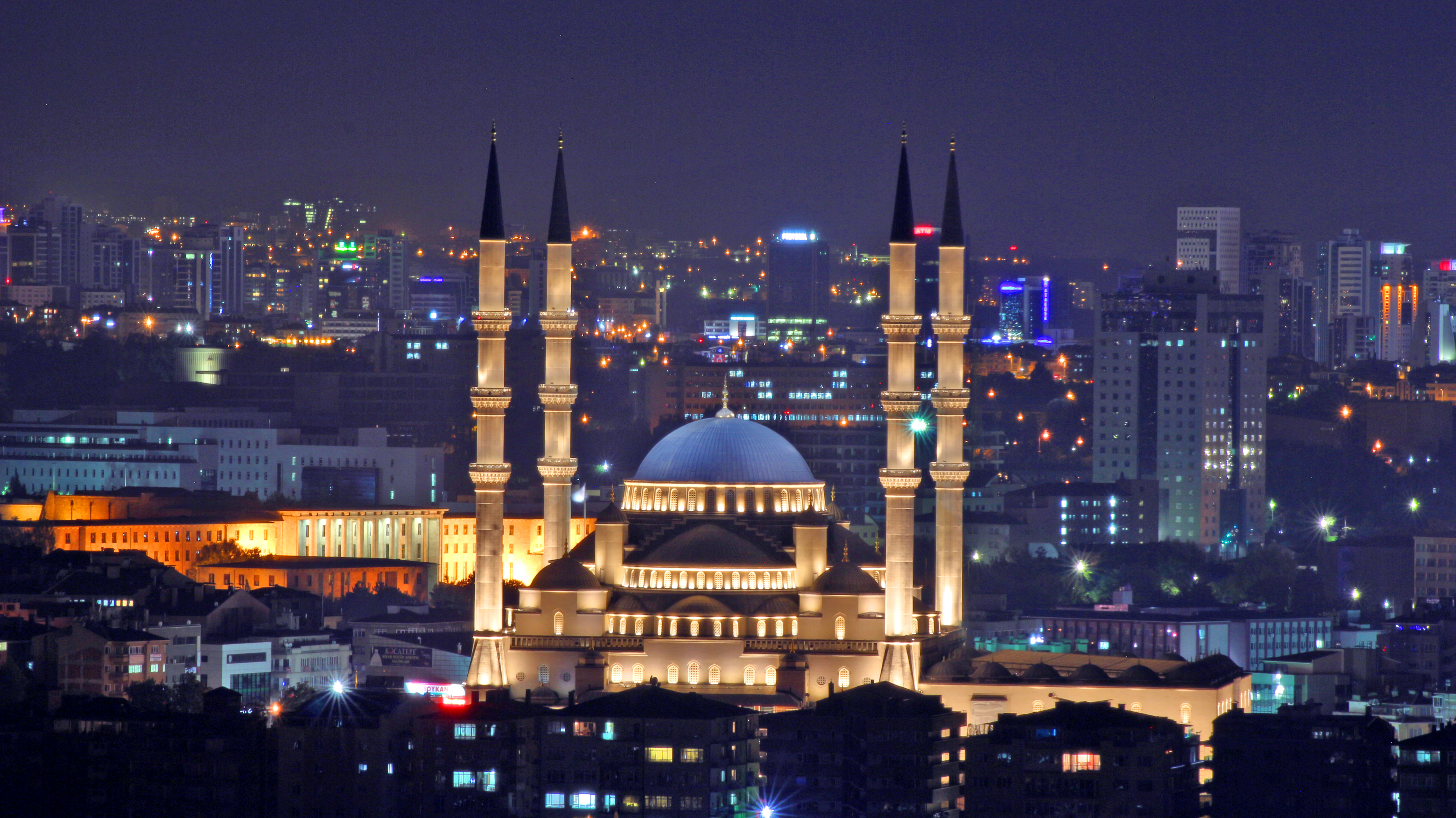
科札德佩清真寺是土耳其首都安卡拉最大的清真寺,建于1967-1987年,有4个叫拜楼,可容纳24,000人礼拜,是世界最大的清真寺之一。其建筑灵感来自埃迪尔内的塞利米耶清真寺,以及伊斯坦布尔的塞札特清真寺和苏丹艾哈迈德清真寺。
Die Kocatepe-Moschee (türkisch Kocatepe Camii) ist die größte Moschee der türkischen Hauptstadt Ankara. Sie befindet sich im Quartier Kocatepe, südlich der Altstadt.
Der Bau der Moschee begann 1967 nach Plänen für eine moderne Moschee des Architekten Vedat Dalokay, die später zugunsten einer Moschee im klassischen Stil nach Entwürfen von Hüsrev Tayla aufgegeben wurden. Sie wurde 1987 vollendet. Sie ist mit vier Minaretten und einer großen Kuppel den klassischen osmanischen Moscheen nachgebildet. Im Untergeschoss der Moschee befindet sich ein modernes Kaufhaus, dessen Mieteinnahmen der Finanzierung der Moschee dienen.

 Afghanistan
 Egypt
Egypt
 Azerbaijan
 Bahrain
 China
China
 India
India
 Iraq
Iraq
 Iran
Iran
 Israel
 Jordan
 Cambodia
 Kasachstan
 Kyrgyzstan

 Mongolei
 Pakistan
 Palestine
 Republic of Korea
 Russia
 Tajikistan
 Thailand
 Turkey
 Uzbekistan
 United Arab Emirates
 Vietnam
 International cities

 Important port
 Art
Art
 History
 Science and technology
 Geography
 Energy resource
 Religion
 Companies
 Architecture
 Hand in Hand
