Deutsch-Chinesische Enzyklopädie, 德汉百科
 体育
体育


 体育
体育
 (F)欧洲足球俱乐部冠军联赛
土耳其
欧洲足球俱乐部冠军联赛 2016/17
B组
欧洲足球俱乐部冠军联赛 2017/18
G组
欧洲足球俱乐部联赛2018/19
I组
欧洲足球俱乐部联赛2019/20
K组
比森特·德尔·博斯克
(F)欧洲足球俱乐部冠军联赛
土耳其
欧洲足球俱乐部冠军联赛 2016/17
B组
欧洲足球俱乐部冠军联赛 2017/18
G组
欧洲足球俱乐部联赛2018/19
I组
欧洲足球俱乐部联赛2019/20
K组
比森特·德尔·博斯克

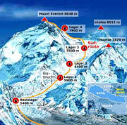
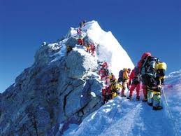
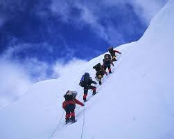
珠穆朗玛峰山体呈巨型金字塔状,威武雄壮昂首天外,地形极端险峻,环境异常复杂。雪线高度:北坡为5800—6200米,南坡为5500—6100米。东北山脊、 东南山脊和西山山脊中间夹着三大陡壁(北壁、东壁和西南壁),在这些山脊 和峭壁之间又分布着548条大陆型冰川,总面积达1457.07平方公里,平均厚度达7260米。冰川的补给主要靠印度洋季风带两大降水带积雪变质形成。冰川上 有千姿百态、瑰丽罕见的冰塔林,又有高达数十米的冰陡崖和步步陷井的明暗 冰裂隙,还有险象环生的冰崩雪崩区。(Quelle:http://news.xinhuanet.com)
珠穆朗玛峰(藏文:ཇོ་མོ་གླང་མ;藏语拼音:qomolangma;威利:jo mo glang ma,香港称珠穆朗玛峰,台湾称圣母峰),中文简称珠峰,尼泊尔名萨加玛塔峰(尼泊尔语:सगरमाथा),英国名埃佛勒斯峰(英语:Mount Everest),为地球第一高峰,属于喜马拉雅山脉,位于中国西藏自治区与尼泊尔萨加玛塔专区边界上。2005年中国国家测绘局测量的岩面高为8,844.43米(29,017.2英尺),尼泊尔则使用传统的雪盖高8,848米(29,029英尺),BBC报道称2010年起两国官方互相承认对方的测量数据[5],中国国家测绘地理信息局则在2018年2月声明否认此说法,仍采用8,844.43米数据至今[6]。它除了是海拔最高的山峰之外,也是距离地心第五远的高峰。[7]它附近的高峰包括8,516米(27,940英尺)的洛子峰、7,855米(25,771英尺)的努子峰和7,580米(24,870英尺)的章子峰。
清朝经过测绘于1719年出版的全国地图上称此峰为“朱姆朗马阿林”,但没有标出高度或用经纬度标出其位置。1856年英属印度测量局首次公布此峰的经纬度及海拔高度,主张此峰8,840米(29,000英尺)是世界第一高峰。1865年英国皇家地理学会接受印度测量局局长安德鲁·史考特·华欧的建议,将此峰命名为“埃佛勒斯峰”,以纪念前任局长乔治·埃佛勒斯。1952年,中国采用“珠穆朗玛峰”为官方名称。
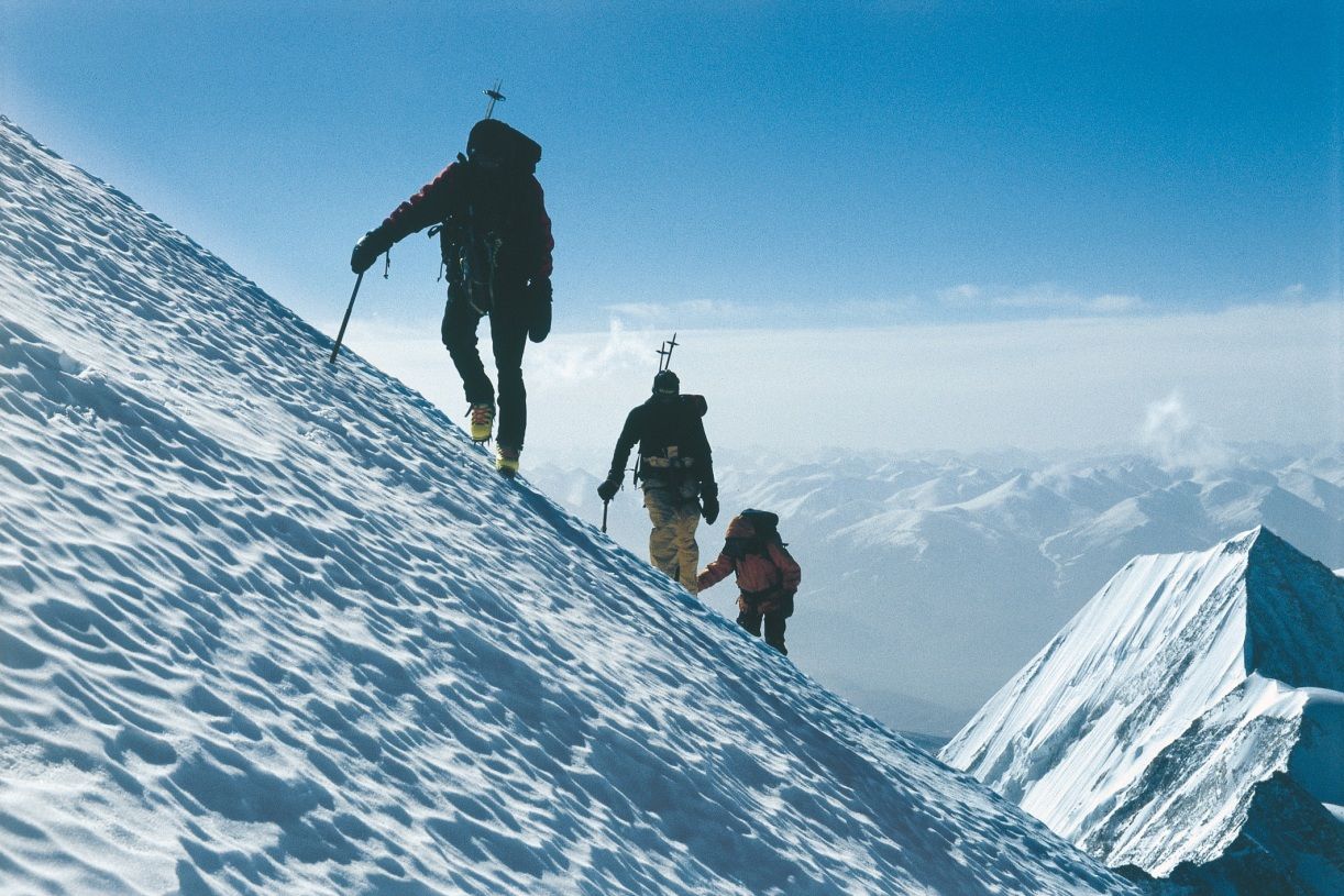
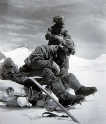
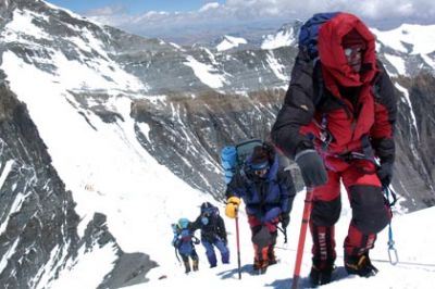
珠穆朗玛峰吸引了许多登山者。主要的攀登路线有两条,一条从尼泊尔东南部出发,经过与洛子峰之间的南坳登顶,称为“标准路线”;另一条则从西藏的北部出发,经过与章子峰之间的北坳登顶。从标准路线登顶对登山技术的挑战不算高,但这条路线的风险包括雪崩、摔落山谷、高山症、冻伤和通过昆布冰瀑的危险。到2016年为止,山上有超过200具尸体,其中一些成为地标。[8][9]
据气象记载,珠穆朗玛峰山顶最低温度为-60°C,最低月平均温度为-35°C,全年平均温度为-29°C,参照北极、南极,因此也被称为“世界第三极”。[10]
Der Mount Everest ist ein Berg im Himalaya und mit einer Höhe von 8848 m der höchste Berg der Erde. Er gehört zu den 14 Achttausendern und zu den Seven Summits. Der Mount Everest ist seit 1856 nach dem britischen Landvermesser George Everest benannt. Auf Nepali heißt der Berg Sagarmatha, auf Tibetisch Qomolangma (deutsche Aussprache „Tschomolangma“; englische Umschrift Chomolungma).
Der Mount Everest befindet sich im Mahalangur Himal in der Region Khumbu in Nepal an der Grenze zu China (Autonomes Gebiet Tibet); der westliche und südöstliche seiner drei Gipfelgrate bilden die Grenze. Auf nepalesischer Seite ist er Teil des Sagarmatha-Nationalparks, der zum UNESCO-Welterbe gehört. Auf der Nordseite gehört er zum Qomolangma National Nature Reserve, das mit dem von der UNESCO ausgewiesenen Qomolangma-Biosphärenreservat korrespondiert.[1]
Edmund Hillary und Tenzing Norgay gelang am 29. Mai 1953 die Erstbesteigung des „dritten Pols“. Am 8. Mai 1978 bestiegen Reinhold Messner und Peter Habeler den Gipfel erstmals ohne zusätzlichen Sauerstoff.
エベレスト、エヴェレスト(英: Everest)、またはチョモランマ(チベット語: ཇོ་མོ་གླང་མ[1] Chomolungma, Qomolangma)、サガルマータ(ネパール語: सगरमाथा Sagarmāthā)は、ヒマラヤ山脈にある世界最高峰である。
エベレストはインド測量局(Survey of India)で長官を務めたジョージ・エベレストにちなんで命名された。
1920年代から長きにわたる挑戦の末、1953年にイギリス探検隊のメンバーでニュージーランド出身の登山家であるエドモンド・ヒラリーとネパール出身のシェルパであるテンジン・ノルゲイによって初登頂がなされた。
エベレストの標高については諸説あり、1954年にインド測量局が周辺12ヶ所で測定しその結果を平均して得られた8,848 mという数値が長年一般に認められてきた。1999年、全米地理学協会はGPSによる測定値が8,850mだったと発表した[2]。厳密には地殻変動などの影響によって標高は年々変動していると考えられている。
エベレストの南麓に位置するネパールのサガルマータ国立公園はユネスコの世界遺産に登録されている。
Mount Everest, known in Nepali as Sagarmatha (सगरमाथा) and in Tibetan as Chomolungma (ཇོ་མོ་གླང་མ), is Earth's highest mountain above sea level, located in the Mahalangur Himal sub-range of the Himalayas. The international border between Nepal (Province No. 1) and China (Tibet Autonomous Region) runs across its summit point.
The current official elevation of 8,848 m (29,029 ft), recognized by China and Nepal, was established by a 1955 Indian survey and subsequently confirmed by a Chinese survey in 1975.[1] In 2005, China remeasured the rock height of the mountain, with a result of 8844.43 m. There followed an argument between China and Nepal as to whether the official height should be the rock height (8,844 m., China) or the snow height (8,848 m., Nepal). In 2010, an agreement was reached by both sides that the height of Everest is 8,848 m, and Nepal recognizes China's claim that the rock height of Everest is 8,844 m.[5]
In 1865, Everest was given its official English name by the Royal Geographical Society, upon a recommendation by Andrew Waugh, the British Surveyor General of India. As there appeared to be several different local names, Waugh chose to name the mountain after his predecessor in the post, Sir George Everest, despite George Everest's objections.[6]
Mount Everest attracts many climbers, some of them highly experienced mountaineers. There are two main climbing routes, one approaching the summit from the southeast in Nepal (known as the "standard route") and the other from the north in Tibet. While not posing substantial technical climbing challenges on the standard route, Everest presents dangers such as altitude sickness, weather, and wind, as well as significant hazards from avalanches and the Khumbu Icefall. As of 2017, nearly 300 people have died on Everest, many of whose bodies remain on the mountain.[7]
The first recorded efforts to reach Everest's summit were made by British mountaineers. As Nepal did not allow foreigners into the country at the time, the British made several attempts on the north ridge route from the Tibetan side. After the first reconnaissance expedition by the British in 1921 reached 7,000 m (22,970 ft) on the North Col, the 1922 expedition pushed the north ridge route up to 8,320 m (27,300 ft), marking the first time a human had climbed above 8,000 m (26,247 ft). Seven porters were killed in an avalanche on the descent from the North Col. The 1924 expedition resulted in one of the greatest mysteries on Everest to this day: George Mallory and Andrew Irvine made a final summit attempt on 8 June but never returned, sparking debate as to whether or not they were the first to reach the top. They had been spotted high on the mountain that day but disappeared in the clouds, never to be seen again, until Mallory's body was found in 1999 at 8,155 m (26,755 ft) on the north face. Tenzing Norgay and Edmund Hillary made the first official ascent of Everest in 1953, using the southeast ridge route. Norgay had reached 8,595 m (28,199 ft) the previous year as a member of the 1952 Swiss expedition. The Chinese mountaineering team of Wang Fuzhou, Gonpo, and Qu Yinhua made the first reported ascent of the peak from the north ridge on 25 May 1960.[8][9]
L’Everest, en tibétain ཇོ་མོ་གླང་མ, Qomolangma ou encore Chomolungma, en népalais सगरमाथा, Sagarmāthā, aussi appelé mont Everest, est une montagne située dans la chaîne de l'Himalaya, à la frontière entre le Népal (province no 1 (en)) et la Chine (Tibet).
Il est aperçu par des Européens pour la première fois en 1847 puis, après quelques années d'observations et de calculs, son altitude est établie à 8 848 mètres et il est identifié comme le plus haut sommet du monde. Cette caractéristique lui vaut d'être baptisé de son nom actuel par les Occidentaux en 1865 et, dès les années 1920, de lui attirer l'intérêt des alpinistes qui se lancent à l'assaut de ses pentes. Plusieurs expéditions, en particulier britanniques, se succèdent depuis le versant nord au Tibet. Toutefois, les conditions climatiques extrêmes font leurs premières victimes, parmi lesquelles George Mallory et Andrew Irvine, en 1924, dont on ne saura probablement jamais avec certitude s'ils ont atteint le sommet. En 1950, le Népal autorise l'accès à la montagne depuis le sud offrant des possibilités d'ascension par l'arête Sud-Est, moins périlleuse. Finalement, trois ans plus tard, Edmund Hillary et Tensing Norgay réussissent à vaincre l'Everest. Dès lors, les exploits en tous genres s'enchaînent, alimentant les fantasmes populaires ; mais, en 1996, une série d'accidents mortels vient rappeler les dangers liés à la montagne, portant de nos jours à plus de 200 le nombre de victimes. Pourtant, le tourisme de masse se popularise, fragilisant le milieu naturel malgré les créations du parc national de Sagarmatha en 1976 et de la réserve naturelle du Qomolangma en 1988. Ainsi, plus de 14 000 alpinistes ont tenté l'ascension depuis 1922 et plus de 4 000 l'ont réussie, bien aidés, pour la majorité d'entre eux, par les porteurs sherpas.
Il monte Everest (pron. /ˈɛverest/[1]) è la vetta più alta del continente asiatico e della Terra con i suoi 8 848 m di altitudine s.l.m., situato nella catena dell'Himalaya assieme ad altri ottomila, al confine fra Cina e Nepal. Rientra dunque nelle cosiddette Sette Vette del Pianeta.
El monte Everest es la montaña más alta del planeta Tierra, con una altitud de 8.848 metros (29 029 pies) sobre el nivel del mar.1 Está localizada en el continente asiático, en la cordillera del Himalaya, concretamente en la subcordillera de Mahalangur Himal; marca la frontera entre China y Nepal, considerada como la frontera más alta del mundo.[cita requerida] El macizo incluye los picos vecinos Lhotse, 8516 m (27 940 pies); Nuptse, 7855 m (25 771 pies) y Changtse, 7580 m (24 870 pies).
 安达卢西亚自治区
路易斯·阿拉贡内斯
西班牙足球甲级联赛
西班牙足球甲级联赛 2015/16
西班牙足球甲级联赛 2016/17
西班牙足球甲级联赛 2017/18
西班牙足球甲级联赛 2018/19
欧洲足球俱乐部联赛2018/19
F组
安达卢西亚自治区
路易斯·阿拉贡内斯
西班牙足球甲级联赛
西班牙足球甲级联赛 2015/16
西班牙足球甲级联赛 2016/17
西班牙足球甲级联赛 2017/18
西班牙足球甲级联赛 2018/19
欧洲足球俱乐部联赛2018/19
F组