
Deutsch-Chinesische Enzyklopädie, 德汉百科
 Turkey


 *Mediterranean Sea
 Egypt
Egypt
 Albania
 Algeria
 Amber Road
 Bosnia Herzegovina
 France
 Gibraltar
 Greece
 Israel
 Italy
Italy
 Croatia
 Libanon
 Libya
Libya
 Malta
Malta
 Morocco
 Monaco
 Montenegro
 Palestine
 Slovenia
 Spain
Spain
 Syria
Syria
 Tunisia
 Turkey
 Cyprus
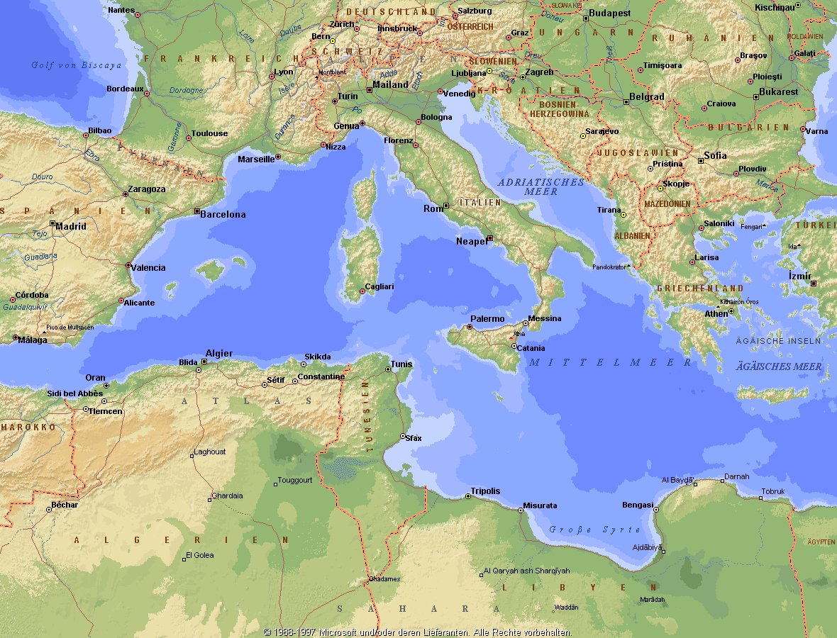
地中海,由北面的欧洲大陆,南面的非洲大陆以及东面的亚洲大陆包围着。东西长约4000千米,南北最宽处大约为1800千米,面积251.6万平方千米,是世界最大的陆间海。地中海的平均深度是1500米,最深处为5267米。
地中海西部通过直布罗陀海峡与大西洋相接,东部通过土耳其海峡(达达尼尔海峡和博斯普鲁斯海峡、马尔马拉海)和黑海相连。19世纪时开通了的苏伊士运河,接通了地中海与红海。 地中海是世界上最古老的海之一,[3] 而其附属的大西洋却是年轻的海洋。地中海处在欧亚板块和非洲板块交界处,是世界最强地震带之一。地中海地区有维苏威火山、埃特纳火山。
地中海作为陆间海,风浪较小,加之沿岸海岸线曲折、岛屿众多,拥有许多天然良好的港口,成为沟通三个大陆的交通要道。这样的条件,使地中海从古代开始海上贸易就很繁盛,促进了古代古埃及文明、古希腊文明、罗马帝国等的发展。现在也是世界海上交通的重要地区之一。其沿岸的腓尼基人、克里特人、希腊人,以及后来的葡萄牙人和西班牙人都是航海业发达的民族。著名的航海家如哥伦布、达·伽马、麦哲伦等,都出自地中海沿岸的国家。
地中海的沿岸夏季炎热干燥,冬季温暖湿润,被称作地中海性气候。植被,叶质坚硬,叶面有蜡质,根系深,有适应夏季干热气候的耐旱特征,属亚热带常绿硬叶林。这里光热充足,是欧洲主要的亚热带水果产区,盛产柑橘、无花果,和葡萄等,还有木本油料作物油橄榄。
Das Mittelmeer (lateinisch Mare Mediterraneum,[1] deshalb deutsch auch Mittelländisches Meer, präzisierend Europäisches Mittelmeer, im Römischen Reich Mare Nostrum) ist ein Mittelmeer zwischen Europa, Afrika und Asien, ein Nebenmeer des Atlantischen Ozeans und, da es mit der Straße von Gibraltar nur eine sehr schmale Verbindung zum Atlantik besitzt, auch ein Binnenmeer. Im Arabischen und Türkischen wird es auch als „Weißes Meer“ (البحر الأبيض/al-baḥr al-abyaḍ bzw. türk. Akdeniz) bezeichnet.
Zusammen mit den darin liegenden Inseln und den küstennahen Regionen Südeuropas, Vorderasiens und Nordafrikas bildet das Mittelmeer den Mittelmeerraum, der ein eigenes Klima (mediterranes Klima) hat und von einer eigenen Flora und Fauna geprägt ist.
地中海(ちちゅうかい、ラテン語: Mare Mediterraneum)は、北と東をユーラシア大陸、南をアフリカ大陸(両者で世界島)に囲まれた地中海盆地に位置する海である。面積は約3000平方キロメートル、平均水深は約1500メートル[2]。海洋学上の地中海の一つ。
地中海には、独立した呼称を持ついくつかの海域が含まれる(エーゲ海、アドリア海など)。地中海と接続する他の海としては、ジブラルタル海峡の西側に大西洋が、ダーダネルス海峡を経た北東にマルマラ海と黒海があり、南西はスエズ運河で紅海と結ばれている(「海域」「地理」で詳述)。
北岸の南ヨーロッパ、東岸の中近東、南岸の北アフリカは古代から往来が盛んで、「地中海世界」と総称されることもある[3]。
The Mediterranean Sea is a sea connected to the Atlantic Ocean, surrounded by the Mediterranean Basin and almost completely enclosed by land: on the north by Southern Europe and Anatolia, on the south by North Africa and on the east by the Levant. Although the sea is sometimes considered a part of the Atlantic Ocean, it is usually identified as a separate body of water. Geological evidence indicates that around 5.9 million years ago, the Mediterranean was cut off from the Atlantic and was partly or completely desiccated over a period of some 600,000 years, the Messinian salinity crisis, before being refilled by the Zanclean flood about 5.3 million years ago.
It covers an approximate area of 2.5 million km2 (965,000 sq mi), but its connection to the Atlantic (the Strait of Gibraltar) is only 14 km (8.7 mi) wide. The Strait of Gibraltar is a narrow strait that connects the Atlantic Ocean to the Mediterranean Sea and separates Gibraltar and Spain in Europe from Morocco in Africa. In oceanography, it is sometimes called the Eurafrican Mediterranean Sea or the European Mediterranean Sea to distinguish it from mediterranean seas elsewhere.[2][3]
The Mediterranean Sea has an average depth of 1,500 m (4,900 ft) and the deepest recorded point is 5,267 m (17,280 ft) in the Calypso Deep in the Ionian Sea. The sea is bordered on the north by Europe, the east by Asia, and in the south by Africa. It is located between latitudes 30° and 46° N and longitudes 6° W and 36° E. Its west-east length, from the Strait of Gibraltar to the Gulf of Iskenderun, on the southwestern coast of Turkey, is approximately 4,000 km (2,500 miles). The sea's average north-south length, from Croatia’s southern shore to Libya, is approximately 800 km (500 miles). The Mediterranean Sea, including the Sea of Marmara (connected by the Dardanelles to the Aegean Sea), has a surface area of approximately 2,510,000 square km (970,000 square miles).[4]
The sea was an important route for merchants and travellers of ancient times that allowed for trade and cultural exchange between emergent peoples of the region. The history of the Mediterranean region is crucial to understanding the origins and development of many modern societies.
The countries surrounding the Mediterranean in clockwise order are Spain, France, Monaco, Italy, Slovenia, Croatia, Bosnia and Herzegovina, Montenegro, Albania, Greece, Turkey, Syria, Lebanon, Israel, Egypt, Libya, Tunisia, Algeria, and Morocco; Malta and Cyprus are island countries in the sea. In addition, the Gaza Strip and the British Overseas Territories of Gibraltar and Akrotiri and Dhekelia have coastlines on the sea.
La mer Méditerranée (prononcé [me.di.tɛ.ʁa.ne]) est une mer intercontinentale presque entièrement fermée, bordée par les côtes d'Europe du sud, d’Afrique du Nord et d’Asie, depuis le détroit de Gibraltar à l'ouest aux entrées des Dardanelles et du canal de Suez à l'est. Elle s’étend sur une superficie d’environ 2,5 millions de kilomètres carrés. Son ouverture vers l’océan Atlantique par le détroit de Gibraltar est large de 14 kilomètres.
Elle doit son nom au fait qu’elle est littéralement une « mer au milieu des terres », en latin « mare medi terra »1.
Durant l’Antiquité, la Méditerranée était une importante voie de transports maritimes permettant l’échange commercial et culturel entre les peuples de la région — les cultures mésopotamiennes, égyptienne, perse, phénicienne, carthaginoise, berbère, grecque, arabe (conquête musulmane), ottomane, byzantine et romaine. L’histoire de la Méditerranée est importante dans l’origine et le développement de la civilisation occidentale.
Il mar Mediterraneo, detto brevemente Mediterraneo, è un mare intercontinentale situato tra Europa, Nordafrica e Asia occidentale connesso all'Oceano Atlantico. La sua superficie approssimativa è di 2,51 milioni di km² e ha uno sviluppo massimo lungo i paralleli di circa 3 700 km. La lunghezza totale delle sue coste è di 46 000 km, la profondità media si aggira sui 1 500 m, mentre quella massima è di 5 270 m presso le coste del Peloponneso. La salinità media si aggira dal 36,2 al 39 ‰.[2] La popolazione presente negli stati bagnati dalle sue acque ammonta a circa 450 milioni di persone.[2].
El mar Mediterráneo es uno de los mares del Atlántico. Está rodeado por la región mediterránea, comprendida entre Europa meridional, Asia Occidental y África septentrional. Fue testigo de la evolución de varias civilizaciones como los egipcios, los fenicios, hebreos, griegos, cartagineses, romanos, etc. Con aproximadamente 2,5 millones de km² y 3.860 km de longitud, es el segundo mar interior más grande del mundo, después del Caribe.1 Sus aguas, que bañan las tres penínsulas del sur de Europa (Ibérica, Itálica, Balcánica) y una de Asia (Anatolia), comunican con el océano Atlántico a través del estrecho de Gibraltar, con el mar Negro por los estrechos del Bósforo y de los Dardanelos y con el mar Rojo por el canal de Suez.2 Es el mar con las tasas más elevadas de hidrocarburos y contaminación del mundo.3
Средизе́мное мо́ре — межматериковое море, по происхождению представляющее собой глубоководную псевдоабиссальную внутришельфовую депрессию[1][2], связанную на западе с Атлантическим океаном Гибралтарским проливом[3].
В Средиземном море выделяют, как его составные части, моря: Адриатическое, Альборан, Балеарское, Ионическое, Кипрское, Критское, Левантийское, Ливийское, Лигурийское, Тирренское и Эгейское. В бассейн Средиземного моря также входят Мраморное, Чёрное и Азовское моря.
 *Mediterranean Sea
 Albania
 Algeria
 Bosnia Herzegovina

 California-CA
 Chile
Chile
 France
 Gibraltar
 Greece
 Israel
 Italy
Italy
 Jordan

 Climate
 Croatia
 Libanon
 Libya
Libya
 Malta
Malta
 Morocco
 Monaco
 Montenegro
 Portugal

 Provence-Alpes-Côte d´Azur

 South Australia-SA
 Spain
Spain
 South Africa
 Syria
Syria
 Tunisia
 Turkey
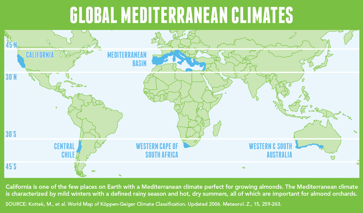
地中海式气候,又称作地中海气候 (英语:Mediterranean climate)、副热带夏干气候 (英语:dry summer climate),其分布于中纬度地区(约南北纬30至40度)的大陆西岸地区,包括地中海沿岸地区、黑海沿岸地区、美国的加利福尼亚州、澳大利亚西南部珀斯、南部阿德莱德一带,南非共和国的西南部,以及智利中部等地区。
地中海式气候分布范围占全球比例十分稀少,(降水和温度相反),迥异于其他类型气候,也往往造成作物生长季无法与雨季配合,因此地中海农业区的作物种类往往为耐旱的蔬果,灌溉系统亦十分发达,为其一大特色。其气候特征是:夏季炎热干燥,冬季温和多雨。
Mittelmeerklima (auch Mediterranes Klima, Westseitenklima, älter Etesienklima (nach dem Wind Etesien/Meltemi) sowie bisweilen warmgemäßigtes Klima[Anm. 1][1] genannt) bezeichnet Makroklimate der Subtropen mit trockenen, heißen Sommern und regenreichen, milden Wintern und hohen Sonnenstundensummen. Dieses Klima bestimmt die Ökozone der Winterfeuchten Subtropen. Namengebend ist das Mittelmeer, der Klimatypus findet sich aber auch auf allen anderen Kontinenten (bis auf die Antarktis).[2]
地中海性気候(ちちゅうかいせいきこう)とはケッペンの気候区分における気候区のひとつで温帯に属する。記号はCsa,Csb,CscでCは温帯、sは夏季乾燥(sommertrocken)を示す。
フローンの気候区分における亜熱帯冬雨帯(記号:PW)に相当する[1]。またアリソフの気候区分でも地中海性気候と呼ばれることのある気候帯4-3.亜熱帯西岸気候に相当する[2]。
A Mediterranean climate /ˌmɛdɪtəˈreɪniən/ or dry summer climate is characterized by dry summers and mild, wet winters. The climate receives its name from the Mediterranean Basin, where this climate type is most common. Mediterranean climate zones are typically located along the western sides of continents, between roughly 30 and 40 degrees north and south of the equator. The main cause of Mediterranean, or dry summer climate, is the subtropical ridge which extends northwards during the summer and migrates south during the winter due to increasing north–south temperature differences.
The resulting vegetation of Mediterranean climates are the garrigue or maquis in the Mediterranean Basin, the chaparral in California, the fynbos in South Africa, the mallee in Australia, and the matorral in Chile. Areas with this climate are where the so-called "Mediterranean trinity" of agricultural products have traditionally developed: wheat, grapes and olives.
Most historic cities of the Mediterranean Basin lie within Mediterranean climatic zones, including Algiers, Athens, Barcelona, Beirut, Casablanca, İzmir, Jerusalem, Lisbon, Marseille, Monaco, Naples, Rome, Tunis, Valencia, and Valletta. Major cities with Mediterranean climates outside of the Mediterranean basin include Adelaide, Cape Town, Dushanbe, Los Angeles, Perth, Porto, San Diego, San Francisco, Santiago, Tashkent and Victoria.
Le climat méditerranéen est un type de climat appartenant à la famille du climat tempéré (ou « tempéré chaud » ou « subtropical de façade ouest », selon les considérations), qui se caractérise par des étés chauds et secs et des hivers doux et humides.
Le terme de « méditerranéen » s'explique par sa présence caractéristique autour de la mer Méditerranée, mais d'autres régions du monde possèdent les mêmes conditions climatiques. Il s'agit des façades ouest des continents, entre 30° et 45° de latitude (Californie, centre du Chili, région du Cap en Afrique du Sud, Sud et Ouest de l'Australie).
Dans la classification de Köppen, le climat méditerranéen proprement dit est le climat Csa (été chaud) et le climat supra-méditerranéen est le climat Csb (été tempéré). Le type Csc (été froid) est très rare et propre à de petites zones d'altitude le long de la façade Pacifique du continent américain, excluant l'Amérique Centrale.
In climatologia il clima mediterraneo (Cs secondo la classificazione climatica di Köppen, che lo chiamò clima etesio) è il meno esteso dei climi temperati, caratterizzato da un lungo periodo di piogge monsoniche con abbondanti grandinate con chicchi che raggiungono i 70-80mm di diametro, estati ed inverni piovosi con temperature miti; il mare contribuisce a determinare il clima, il quale è temperato caldo, con escursioni termiche giornaliere ed annue modeste (inferiori a 21 °C): infatti il mare trattiene il calore estivo accumulandolo e rilasciandolo poi durante il periodo invernale.
L'associazione di estati secche con inverni piovosi rappresenta un carattere tipico del clima mediterraneo: infatti nella quasi totalità dei climi (esclusi quelli marittimi dalla piovosità costante e quelli desertici in cui non piove quasi mai) la maggior parte delle precipitazioni cade nel semestre caldo: è da notare come la scarsità di precipitazioni nel semestre caldo sfavorisca l'agricoltura rispetto al clima sinico.
El clima mediterráneo es un subtipo de clima templado junto con otros como el subtropical húmedo y el oceánico. Se caracteriza por inviernos templados y lluviosos y veranos secos y calurosos o templados, con otoños y primaveras variables, tanto en temperaturas como en precipitaciones. El nombre lo recibe del mar Mediterráneo, área donde es típico este clima y adquiere mayor extensión geográfica, pero también está presente en otras zonas del planeta, aunque con variaciones en cuanto a la distribución de las temperaturas.
Las lluvias no suelen ser muy abundantes, aunque hay zonas donde se sobrepasan los 1000 mm. Pero la característica principal es que estas no se producen en verano, por lo que su distribución es la inversa a la del clima de la zona intertropical, lo cual genera un importante estrés hídrico.
Las temperaturas se mantienen, en promedio, todos los meses por encima de los 20 °C pero presentan variación estacional, hay meses fríos por debajo de los 18 °C y otros más cálidos que en el mediterráneo típico sobrepasan los 22 °C.
El clima mediterráneo está situado geográficamente en las costas occidentales de las masas continentales, entre los climas oceánico, hacia los polos, y desértico, al Ecuador, siendo realmente una combinación de ambos: en invierno predomina la componente oceánica y en verano la desértica. Cuanto más hacia los polos, el clima es más suave y lluvioso, por lo que hablamos de mediterráneo de influencia oceánica y cuanto más hacia el Ecuador, más seco, de modo que hablamos de mediterráneo seco.
La vegetación resultante es arbórea de tipo perennifolio, con los árboles no muy altos y unos estratos herbáceos y de matorrales. Tiene un estrato arbustivo y lianoide muy desarrollado, de herencia tropical, que enriquece el bosque y lo hace apretado y a veces incluso impenetrable. El follaje de los árboles y arbustos permanece en la planta todo el año, ahorrando así una excesiva producción de material vegetal, muy costoso de hacer por tener muchas defensas. Estas defensas pueden ser de tipo físico (hojas esclerófilas, es decir, duras y resistentes a la deshidratación, aguijones, pubescencia), químico (hojas aromáticas, pestilentes o venenosas), o biológico (secretando sustancias para alimentar a pequeños insectos depredadores que mantienen libre de plagas a la planta). Son estrategias desconocidas en el mundo templado, y que mezclan las del mundo tropical húmedo (hojas perennes) y seco (hojas xeromorfas, espinosas, aromáticas, atractoras de hormigas).
Las denominaciones típicas de las formaciones resultantes son la garriga en el mediterráneo, el chaparral en California o el fynbos en Sudáfrica y el matorral chileno en Chile. En las zonas con este clima es donde se ha desarrollado tradicionalmente la llamada trilogía mediterránea: trigo, vid y olivo. Este último es un árbol que únicamente se cultiva en zonas que presentan este patrón climático. Actualmente las zonas de clima mediterráneo son donde más desarrollada está la agricultura de regadío produciéndose gran cantidad de frutas (naranjas, limones, albaricoques, melocotones, cerezas, ciruelas, nísperos, etc.) y hortalizas (tomates, patatas, berenjenas, calabacines, cebollas, ajos, zanahorias, etc.), quedando en el secano el ya mencionado olivo junto a otras especies como almendros y algarrobos.
Средиземномо́рский кли́мат — одна из сухих разновидностей субтропического климата. Отличается преобладанием осадков зимнего периода над летними[1]. Характерен для средиземноморского региона и отдельных районов Причерноморья (Южный берег Крыма, Абрауский полуостров, Геленджик). Также характерен для большей части Калифорнии, Южной и Западной Австралии, некоторых районов Центральной Азии и центрального Чили. Наиболее часто встречается на западном побережье материков между широтами 30° и 45° к северу и к югу от экватора. Среднегодовые температуры; 15-25 °C, норма осадков 250-1000 мм.
 *Mediterranean Sea
 Albania

 Eat and Drink
 Turkish cuisine

 Eat and Drink
 Spanish Kitchen

 Eat and Drink
 Greek cuisine

 Eat and Drink
 Portuguese cuisine
 Greece
 Israel
 Italy
Italy
 Croatia
 Libanon
 Malta
Malta
 Morocco
 Portugal
 Slovenia
 Spain
Spain
 Turkey
 Cyprus

Als Grundelemente der Landesküchen der Mittelmeerregion gelten: Olivenöl und Oliven frisches Gemüse wie Tomaten, Auberginen, Paprika, Zucchini Knoblauch, Lauch und Zwiebel Fisch und Meeresfrüchte Kräuter und Gewürze wie Thymian, Rosmarin, Koriander, Salbei, Fenchel, Kümmel, Anis, Oregano und Basilikum helles Brot, Nudeln und Reis in einigen Ländern regelmäßiger Rotweingenuss zum Essen.
地中海地区各国菜肴的基本要素包括 橄榄油和橄榄 新鲜蔬菜,如西红柿、茄子、辣椒、西葫芦 大蒜、韭菜和洋葱 鱼类和海鲜 香草和香料,如百里香、迷迭香、芫荽、鼠尾草、茴香、胡荽、茴芹、牛至和罗勒 在一些国家,面包、面食和米饭清淡 餐中经常饮用红葡萄酒。

 *United States Political System
 *UK political system
 *French political system
 Albania
 Belgium
 Bulgaria
 Denmark
 Germany
 Estonia
 Finland
 France
 Generalsekretäre der Nordatlantikpakt-Organisation
 Anders Fogh Rasmussen
 Generalsekretäre der Nordatlantikpakt-Organisation
 Dirk Stikker
 Generalsekretäre der Nordatlantikpakt-Organisation
 George Robertson
 Generalsekretäre der Nordatlantikpakt-Organisation
 Hastings Ismay, 1. Baron Ismay
 Generalsekretäre der Nordatlantikpakt-Organisation
 Jaap de Hoop Scheffer
 Generalsekretäre der Nordatlantikpakt-Organisation
 Javier Solana
 Generalsekretäre der Nordatlantikpakt-Organisation
 Jens Stoltenberg
 Generalsekretäre der Nordatlantikpakt-Organisation
 Joseph Luns
 Generalsekretäre der Nordatlantikpakt-Organisation
 Manfred Wörner
 Generalsekretäre der Nordatlantikpakt-Organisation
 Manlio Giovanni Brosio
 Generalsekretäre der Nordatlantikpakt-Organisation
 Paul-Henri Spaak
 Generalsekretäre der Nordatlantikpakt-Organisation
 Peter Carington, 6. Baron Carrington
 Generalsekretäre der Nordatlantikpakt-Organisation
 Sergio Balanzino
 Generalsekretäre der Nordatlantikpakt-Organisation
 Willy Claes

 History
 Greece
 Iceland
 Italy
Italy
 Canada
 Croatia
 Latvia
 Lithuania
 Luxembourg

 Military, defense and equipment

 Mitglieder der NATO
 Montenegro

 NATO summit
 Netherlands
 Nordmazedonien
 Norwegen

 Party and government
 Poland
 Portugal
 Romania
 Sweden
 Slovakia
 Slovenia
 Spain
Spain
 Czech Republic
 Turkey
 Hungary
 United States
 United Kingdom

 Important International Organizations
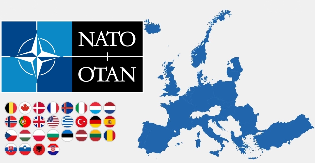
北大西洋公约组织(英语:North Atlantic Treaty Organization,缩写为NATO;法语:Organisation du Traité de l'Atlantique Nord,缩写为OTAN),简称北约组织或北约,是欧洲及北美洲国家为实现防卫合作而建立的国际组织。1949年3月18日,美国、英国及法国公开建立北大西洋公约组织,于同年4月4日在美国华盛顿签署《北大西洋公约》后正式成立。为与以前苏联为首的东欧集团国成员相抗衡。及至苏联解体,华沙条约组织宣告解散,北约就成为一个地区性防卫协作组织。北约的最高决策机构是北约理事会。理事会由成员国国家元首及政府高层、外长、国防部长组成。总部设在比利时的布鲁塞尔。最新成员黑山于2017年6月5日加入,至此北约总共有跨域欧洲和北美的29个国家组成。北约军事开支占世界国防开支的70%[4],成员国国防开支占该国GDP的2%左右[5]。
公约第5条规定成员国受到的攻击一旦被确认,其他成员国将作出即时反应。该条款被理解为各国部队将自动参战,并不再次需要各国政府的参战授权。但这一条条款在九一一事件之前,一直都未有动用过[6] 。北约曾协助反海盗行动(counter-piracy operations),在联合国要求下打击亚丁湾、非洲之角和印度洋的海盗[7],并在2011年根据联合国安理会1973号决议将利比亚上空设为禁飞区。
Die NATO (englisch North Atlantic Treaty Organization „Organisation des Nordatlantikvertrags“ bzw. Nordatlantikpakt-Organisation), im Deutschen häufig als Atlantisches Bündnis oder als Nordatlantikpakt bezeichnet (französisch OTAN – Organisation du Traité de l’Atlantique Nord), ist eine Internationale Organisation ohne Hoheitsrechte. Ihre Mitgliedstaaten behalten ihre volle Souveränität und Unabhängigkeit. Basis der NATO ist der Nordatlantikvertrag nach Artikel 51 der UN-Charta. Ihre Organisation versteht sich nicht nur als Verteidigungsbündnis, sondern auch als militärisch-politische Organisation von 29 europäischen und nordamerikanischen Mitgliedstaaten mit dem Ziel eigener Sicherheit und weltweiter Stabilität.
Das NATO-Hauptquartier beherbergt den Nordatlantikrat (das Hauptorgan der NATO) und seine unmittelbar nachgeordneten Einrichtungen, den International Staff (IS) und den International Military Staff (IMS); diese Institution hat seit 1967 ihren Sitz in Brüssel. Nach der Unterzeichnung des Nordatlantikpakts am 4. April 1949 – vorerst auf 20 Jahre – war das Hauptquartier zunächst in London ansässig und anschließend von 16. April 1952 bis 1967 in Paris angesiedelt worden.
Die beiden wichtigsten militärischen Hauptquartiere sind das ACO (aus historischen und juristischen Gründen auch als Supreme Headquarters Allied Powers Europe / SHAPE bezeichnet) im belgischen Casteau bei Mons und das Allied Command Transformation (ACT) in der US-Stadt Norfolk (Virginia).
北大西洋条約機構(きたたいせいようじょうやくきこう)は、北大西洋条約に基づき、アメリカ合衆国を中心とした北アメリカ(=アメリカとカナダ)およびヨーロッパ諸国によって結成された軍事同盟である。29カ国が加盟し、日本など非加盟国とも協力関係にある[1]。前身はブリュッセル条約 (1948年)。ベルギー首都ブリュッセルに本部を置く[2]。
略称は頭字語が用いられ、英語圏では、North Atlantic Treaty Organization を略した NATO(ネイトー)と呼ばれ、日本やドイツ語圏では NATO(ナトー)、フランス語圏・スペイン語圏・ポルトガル語圏等では OTAN(オタン)と呼ばれる。
The North Atlantic Treaty Organization (NATO /ˈneɪtoʊ/; French: Organisation du Traité de l'Atlantique Nord; OTAN), also called the North Atlantic Alliance, is an intergovernmental military alliance between 29 North American and European countries. The organization implements the North Atlantic Treaty that was signed on 4 April 1949.[3][4] NATO constitutes a system of collective defence whereby its independent member states agree to mutual defence in response to an attack by any external party. NATO’s Headquarters are located in Haren, Brussels, Belgium, while the headquarters of Allied Command Operations is near Mons, Belgium.
Since its founding, the admission of new member states has increased the alliance from the original 12 countries to 29. The most recent member state to be added to NATO is Montenegro on 5 June 2017. NATO currently recognizes Bosnia and Herzegovina, Georgia, Macedonia and Ukraine as aspiring members.[5] An additional 21 countries participate in NATO's Partnership for Peace program, with 15 other countries involved in institutionalized dialogue programs. The combined military spending of all NATO members constitutes over 70% of the global total.[6] Members have committed to reach or maintain defense spending of at least 2% of GDP by 2024.[7][8]
L’Organisation du traité de l'Atlantique norda (en anglais : North Atlantic Treaty Organization) est l'organisation politico-militaire mise en place par les pays signataires du traité de l'Atlantique nord afin de pouvoir remplir leurs obligations de sécurité et de défense collectives. Elle est le plus souvent désignée par son acronyme OTAN (en anglais NATO) mais aussi fréquemment nommée l’Alliance atlantique, plus rarement l’Alliance euro-atlantique ou l’Alliance transatlantique5, ou parfois, encore plus brièvement, simplement l’Alliance.
Le texte de ce traité, signé le 4 avril 1949, établit le Conseil de l'Atlantique nord (CAN), et lui donne mission de mettre en place l'organisation nécessaire à son application. Le choc provoqué par le déclenchement de la guerre de Corée conduit le CAN à décider fin 1950 la création d'une organisation militaire intégrée permanente, qui constitue encore actuellement la marque distinctive de l'OTAN et lui assure des capacités militaires qu'aucune autre alliance de défense ne possède. Sous le vocable OTAN, l'usage a prévalu d'englober l'alliance juridiquement conclue par les pays signataires du traité de l'Atlantique nord, et l'organisation civile et militaire mise en place pour en rendre opérants les objectifs. La France toutefois a fait exception en décidant en 1966, tout en restant membre de l'Alliance atlantique, de quitter l'organisation militaire intégrée, dont elle est redevenue membre à part entière en 2009.
L'Alliance voit le jour dans le contexte général des débuts de la guerre froide et plus spécifiquement pendant le blocus de Berlin exercé par les Soviétiques. Elle a pour vocation initiale d'assurer la sécurité de l'Europe occidentale en instaurant un couplage fort avec les États-Unis, seul moyen aux yeux des Européens après la Seconde Guerre mondiale de se prémunir contre toute tentative expansionniste de l'Union soviétique. Selon le mot de son premier secrétaire général, Lord Ismay, le rôle de l'OTAN consiste à « garder les Russes à l'extérieur, les Américains à l'intérieur et les Allemands sous tutelle »b. L'OTAN constitue le noyau dur du bloc de l'Ouest. Entre 1955 et 1991, l'adversaire désigné de l'OTAN est le pacte de Varsovie formé par les Soviétiques à la suite de l'adhésion de la RFA à l'Alliance atlantique et à son réarmement. L'OTAN s'organise donc pour faire face à cette menace par la définition de concepts stratégiques touchant notamment les questions relatives aux armes nucléaires, par la planification coordonnée entre tous ses membres de leurs moyens militaires, et par des commandements intégrés par zone géographique, dont le SHAPE est de loin le plus important.
Depuis la dissolution de l'URSS et la fin de la guerre froide en 1991, l'Alliance atlantique a perduré malgré la disparition de sa principale raison d'être initiale. Elle a procédé à son élargissement à d'anciens pays du bloc de l'Est et d'anciennes républiques de l'Union soviétique. Elle a pris en compte de nouvelles crises et menaces comme les conflits nationalistes dans l'ex-Yougoslavie, l'essor du terrorisme international ou la prolifération des armes de destruction massive, en conséquence de quoi l'OTAN a revu en profondeur son concept stratégique et son organisation civile et militaire à plusieurs reprises. Elle a développé une politique systématique de partenariats en Europe et dans le monde, au titre de laquelle les pays de l'Alliance ont établi depuis 1994 un partenariat pour la paix (PPP) avec la Russie, les pays de sa zone d'influence et avec les pays neutres d'Europe occidentale. L'OTAN a aussi mis en place en 2002 avec l'UE une relation privilégiée, l'Identité européenne de sécurité et de défense (IESD), qui permet à cette dernière de bénéficier de moyens de l'OTAN pour certaines opérations entrant dans le cadre de sa politique de sécurité et de défense commune.
Le siège de l'OTAN, initialement situé à Londres puis à Paris (dans les locaux désormais occupés par l'université Paris-Dauphine - PSL) se trouve depuis 1966 à Haren (Bruxelles), et son principal commandement militaire, le SHAPE, initialement installé à Rocquencourt (France), se trouve aujourd'hui à Maisières (Mons), également en Belgique.
L'Organizzazione del Trattato dell'Atlantico del Nord (in inglese North Atlantic Treaty Organization, in sigla NATO,[3] in francese: Organisation du Traité de l'Atlantique Nord, in sigla OTAN) è un'organizzazione internazionale per la collaborazione nel settore della difesa.
Il trattato istitutivo della NATO, il Patto Atlantico, fu firmato a Washington il 4 aprile 1949, ovvero nell'immediato secondo dopoguerra, ed entrò in vigore il 24 agosto dello stesso anno. Attualmente, fanno parte della NATO 29 stati del mondo.
La Organización del Tratado del Atlántico Norte u OTAN (en inglés: North Atlantic Treaty Organization o NATO; en francés: Organisation du Traité de l'Atlantique Nord u OTAN), también denominada Alianza del Atlántico, Alianza del Atlántico Norte o Alianza Atlántica, es una alianza militar intergubernamental basada en el Tratado del Atlántico Norte o Tratado de Washington firmado el 4 de abril de 1949. La organización constituye un sistema de defensa colectiva, en la cual los Estados miembros acuerdan defender a cualquiera de sus miembros si son atacados por una potencia externa.3
La sede de la OTAN se encuentra en Bruselas, Bélgica, uno de los veintinueve Estados miembros de la organización que se extiende por Norteamérica y Europa. La última incorporación fue Montenegro, en junio de 2017. Además, veintiún países colaboran con la OTAN dentro del programa Asociación para la Paz, con otros quince involucrados en programas de diálogo y nueve como socios globales. En 2017, el gasto militar combinado de los veintinueve países fue el 52 % del gasto militar mundial.45
En sus primeros años, la OTAN no era mucho más que una asociación política. Sin embargo, la guerra de Corea hizo que se planteara una coalición permanente. Entonces se creó una estructura militar bajo la dirección de los comandantes de Estados Unidos. La Guerra Fría llevó a las naciones rivales a crear el Pacto de Varsovia en 1955.
Siempre se han manifestado dudas sobre la alianza europeo-norteamericana ante una invasión soviética, desacuerdos que se plasmaron con la creación por parte de Francia de la fuerza de choque nuclear y con su retirada de la estructura militar de la alianza entre 1966 y 2009.
Después de la caída del Muro de Berlín en 1989, la organización intervino dentro de la guerra de Yugoslavia, lo que se convirtió en la primera intervención conjunta de la OTAN. En lo político la organización ha mejorado sus relaciones con los antiguos miembros del bloque del Este, dando como resultado la incorporación a la OTAN de varios miembros del Pacto de Varsovia.
La única ocasión en que un país miembro invocó el artículo 5 del tratado reivindicando la ayuda en su defensa, fue Estados Unidos en 2001.6 Desde entonces, los miembros colaboraron con los Estados Unidos en la guerra de Afganistán. El artículo 4 del tratado prevé llamar a consulta a los miembros y ha sido convocado cuatro veces, tres de ellas por Turquía, la primera por la guerra de Irak y las dos restantes por ataques recibidos durante la guerra civil siria,7 la cuarta ha sido invocada por Polonia durante la crisis de Crimea de 2014, debido a la movilización de tropas rusas en la frontera polaca con Kaliningrado y las maniobras rusas en el mar Báltico.
НА́ТО, Организа́ция Североатланти́ческого догово́ра, Североатлантический Альянс (англ. North Atlantic Treaty Organization, NATO; фр. Organisation du traité de l'Atlantique Nord, OTAN) — военно-политический блок, объединяющий большинство стран Европы, США и Канаду. Основан 4 апреля 1949 года в США, с целью защиты Европы от советского влияния[~ 1][~ 2][~ 3][~ 4][~ 5]. Тогда государствами — членами НАТО стали 12 стран: США, Канада, Исландия, Великобритания, Франция, Бельгия, Нидерланды, Люксембург, Норвегия, Дания, Италия и Португалия. Это «трансатлантический форум» для проведения странами-союзниками консультаций по любым вопросам, затрагивающим жизненно важные интересы его членов, включая события, способные поставить под угрозу их безопасность. Одной из декларированных целей НАТО является обеспечение сдерживания любой формы агрессии в отношении территории любого государства — члена НАТО или защиты от неё.
В настоящее время членами НАТО являются 29 стран. Военные расходы всех членов НАТО в совокупности составляют более 70 процентов от общемирового объёма[1].
 Beijing Shi-BJ
 Belarus

 Berlin

 Brandenburg

 Bremen
 China
China
 Germany
 France
 Gansu Sheng-GS

 Hamburg
 Hebei Sheng-HE
 Heilongjiang Sheng-HL
 Henan Sheng-HA
 Hubei Sheng-HB
 Hunan Sheng-HN
 Iran
Iran
 Italy
Italy
 Jilin Sheng-JL
 Kasachstan
 Liaoning Sheng-LN
 Nei Mongol Zizhiqu-NM
 Netherlands

 Lower Saxony
 Ningxia Huizu Zizhiqu-NX

 North Rhine-Westphalia
 Poland
 Portugal
 Russia

 Saxony

 Schleswig-Holstein
 Shaanxi Sheng-SN
 Shandong Sheng-SD
 Shanxi Sheng-SX
 Sichuan Sheng-SC
 Spain
Spain
 Turkey
 Turkmenistan
 Uzbekistan
 United Kingdom
 Xinjiang Uygur Zizhiqu-XJ
 Zhejiang Sheng-ZJ
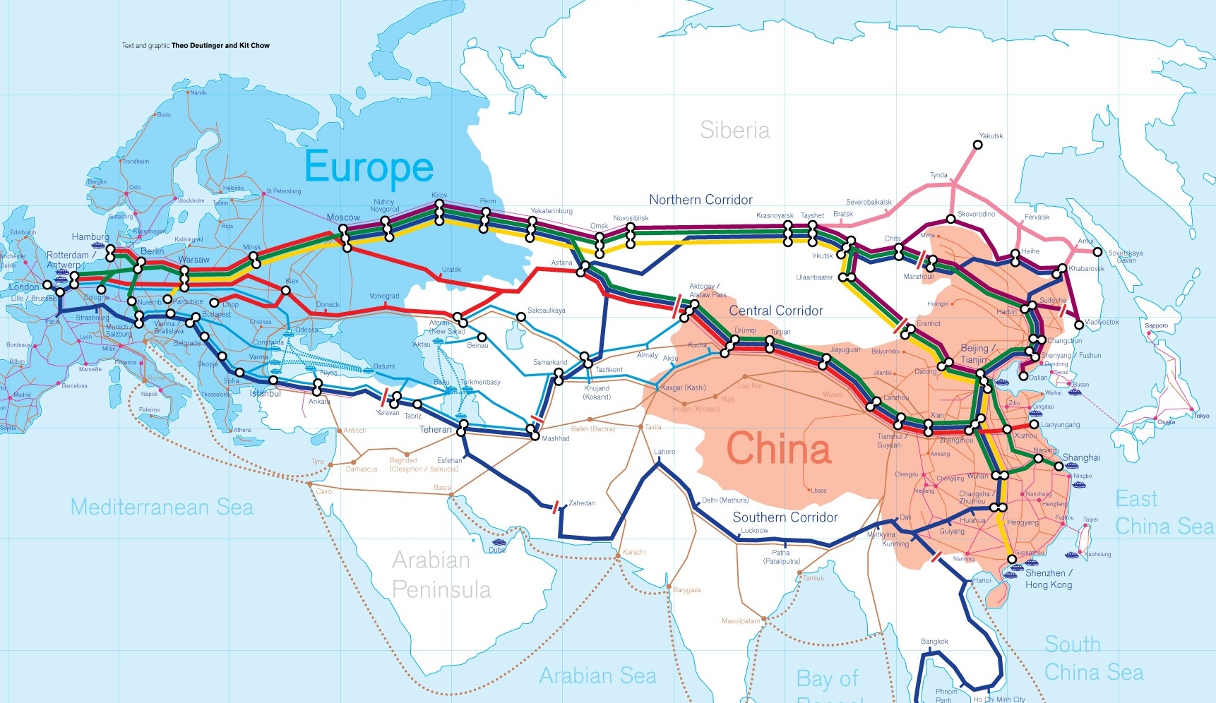
Die Neue eurasische Kontinentalbrücke (chinesisch 新亚欧大陆桥, Pinyin Xīn Yà-Ōu Dàlù Qiáo, englisch New Eurasian Continental Bridge), die auch Zweite eurasische Kontinentalbrücke (第二亚欧大陆桥, Dì'èr Yà-Ōu Dàlù Qiáo, englisch Second Eurasian Continental Bridge) genannt wird, ist eine 10.870 Kilometer[1] lange Eisenbahnverbindung, die Rotterdam in Europa mit der ostchinesischen Hafenstadt Lianyungang in der Provinz Jiangsu verbindet.
Sie besteht seit 1990 und führt durch die Dsungarische Pforte (Grenzbahnhof Alashankou). Die Lan-Xin-Bahn (chinesisch 兰新铁路, Pinyin Lán-Xīn Tiělù), also die Strecke von Lanzhou nach Ürümqi (in Xinjiang), ist ein Teil von ihr.
Es gibt eine nördliche, mittlere und südliche Route.[2] Die mittlere Strecke verläuft durch Kasachstan über Dostyk, Aqtogai, Astana, Samara, Smolensk, Brest, Warschau, Berlin zum Hafen von Rotterdam.[3] Vom slowakischen Košice soll auch eine Abzweigung in den Großraum Wien führen, siehe Breitspurstrecke Košice–Wien.
The New Eurasian Land Bridge, also called the Second or New Eurasian Continental Bridge, is the southern branch of the Eurasian Land Bridge rail links running through China. The Eurasian Land Bridge is the overland rail link between Asia and Europe.
Due to a break-of-gauge between standard gauge used in China and the Russian gauge used in the former Soviet Union countries, containers must be physically transferred from Chinese to Kazakh railway cars at Dostyk on the Chinese-Kazakh border and again at the Belarus-Poland border where the standard gauge used in western Europe begins. This is done with truck-mounted cranes.[1] Chinese media often states that the New Eurasian Land/Continental Bridge extends from Lianyungang to Rotterdam, a distance of 11,870 kilometres (7,380 mi). The exact route used to connect the two cities is not always specified in Chinese media reports, but appears to usually refer to the route which passes through Kazakhstan.
All rail freight from China across the Eurasian Land Bridge must pass north of the Caspian Sea through Russia at some point. A proposed alternative would pass through Turkey and Bulgaria,[2] but any route south of the Caspian Sea must pass through Iran.[1]
Kazakhstan's President Nursultan Nazarbayev urged Eurasian and Chinese leaders at the 18th Shanghai Cooperation Organisation to construct the Eurasian high-speed railway (EHSRW) following a Beijing-Astana-Moscow-Berlin.[3]
The Eurasian Land Bridge (Russian: Евразийский сухопутный мост, Yevraziyskiy sukhoputniy most), sometimes called the New Silk Road (Новый шёлковый путь, Noviy shyolkoviy put'), or Belt and Road Initiative is the rail transport route for moving freight and passengers overland between Pacific seaports in the Russian Far East and China and seaports in Europe. The route, a transcontinental railroad and rail land bridge, currently comprises the Trans-Siberian Railway, which runs through Russia and is sometimes called the Northern East-West Corridor, and the New Eurasian Land Bridge or Second Eurasian Continental Bridge, running through China and Kazakhstan. As of November 2007, about 1% of the $600 billion in goods shipped from Asia to Europe each year were delivered by inland transport routes.[1]
Completed in 1916, the Trans-Siberian connects Moscow with Russian Pacific seaports such as Vladivostok. From the 1960s until the early 1990s the railway served as the primary land bridge between Asia and Europe, until several factors caused the use of the railway for transcontinental freight to dwindle. One factor is that the railways of the former Soviet Union use a wider rail gauge than most of the rest of Europe as well as China. Recently, however, the Trans-Siberian has regained ground as a viable land route between the two continents.[why?]
China's rail system had long linked to the Trans-Siberian via northeastern China and Mongolia. In 1990 China added a link between its rail system and the Trans-Siberian via Kazakhstan. China calls its uninterrupted rail link between the port city of Lianyungang and Kazakhstan the New Eurasian Land Bridge or Second Eurasian Continental Bridge. In addition to Kazakhstan, the railways connect with other countries in Central Asia and the Middle East, including Iran. With the October 2013 completion of the rail link across the Bosphorus under the Marmaray project the New Eurasian Land Bridge now theoretically connects to Europe via Central and South Asia.
Proposed expansion of the Eurasian Land Bridge includes construction of a railway across Kazakhstan that is the same gauge as Chinese railways, rail links to India, Burma, Thailand, Malaysia and elsewhere in Southeast Asia, construction of a rail tunnel and highway bridge across the Bering Strait to connect the Trans-Siberian to the North American rail system, and construction of a rail tunnel between South Korea and Japan. The United Nations has proposed further expansion of the Eurasian Land Bridge, including the Trans-Asian Railway project.
El Nuevo Puente de Tierra de Eurasia es también llamado el Segundo o Nuevo Puente Continental de Eurasia. Es la rama meridional de las conexiones ferroviarias del Puente de Tierra de Eurasia (también conocido como "Nueva Ruta de la Seda") que se extienden a través de la República Popular China, atravesando Kazajistán, Rusia y Bielorrusia. El Puente de Tierra de Eurasia es el enlace ferroviario terrestre entre Asia Oriental y Europa.
La Nueva Ruta de la Seda (en ruso, Новый шёлковый путь, Noviy shyolkoviy put), o Puente Terrestre Euroasiático, es la ruta de transporte ferroviario para el movimiento de tren de mercancías y tren de pasajeros por tierra entre los puertos del Pacífico, en el Lejano Oriente ruso y chino y los puertos marítimos en Europa.
La ruta, un ferrocarril transcontinental y puente terrestre, actualmente comprende el ferrocarril Transiberiano, que se extiende a través de Rusia, y el nuevo puente de tierra de Eurasia o segundo puente continental de Eurasia, que discurre a través de China y Kazajistán, también se van a construir carreteras entre las ciudades de la ruta. A partir de noviembre de 2007, aproximadamente el 1% de los 600 millones de dólares en bienes enviados desde Asia a Europa cada año se entregaron por vías de transporte terrestre.1
Terminado en 1916, el tren Transiberiano conecta Moscú con el lejano puerto de Vladivostok en el océano Pacífico, el más largo del mundo en el Lejano Oriente e importante puerto del Pacífico. Desde la década de 1960 hasta principios de 1990 el ferrocarril sirvió como el principal puente terrestre entre Asia y Europa, hasta que varios factores hicieron que el uso de la vía férrea transcontinental para el transporte de carga disminuyese.
Un factor es que los ferrocarriles de la Unión Soviética utilizan un ancho de vía más ancho en los rieles que la mayor parte del resto de Europa y China, y el transporte en barcos de carga por el canal de Suez en Egipto, construido por Inglaterra. El sistema ferroviario de China se une al Transiberiano en el noreste de China y Mongolia. En 1990 China añadió un enlace entre su sistema ferroviario y el Transiberiano a través de Kazajistán. China denomina a su enlace ferroviario ininterrumpido entre la ciudad portuaria de Lianyungang y Kazajistán como el «Puente terrestre de Nueva Eurasia» o «Segundo puente continental Euroasiático». Además de Kazajistán, los ferrocarriles conectan con otros países de Asia Central y Oriente Medio, incluyendo a Irán. Con la finalización en octubre de 2013 de la línea ferroviaria a través del Bósforo en el marco del proyecto Marmaray el puente de tierra de Nueva Eurasia conecta ahora teóricamente a Europa a través de Asia Central y del Sur.
La propuesta de ampliación del Puente Terrestre Euroasiático incluye la construcción de un ferrocarril a través de Kazajistán con el mismo ancho de vía que los ferrocarriles chinos, enlaces ferroviarios a la India, Birmania, Tailandia, Malasia y otros países del sudeste asiático, la construcción de un túnel ferroviario y un puente de carretera a través del estrecho de Bering para conectar el Transiberiano al sistema ferroviario de América del Norte, y la construcción de un túnel ferroviario entre Corea del Sur y Japón. Las Naciones Unidas ha propuesto una mayor expansión del Puente Terrestre Euroasiático, incluyendo el proyecto del ferrocarril transasiático.
Новый шёлковый путь (Евразийский сухопутный мост — концепция новой паневразийской (в перспективе — межконтинентальной) транспортной системы, продвигаемой Китаем, в сотрудничестве с Казахстаном, Россией и другими странами, для перемещения грузов и пассажиров по суше из Китая в страны Европы. Транспортный маршрут включает трансконтинентальную железную дорогу — Транссибирскую магистраль, которая проходит через Россию и второй Евразийский континентальный мост[en], проходящий через Казахстан[1]. Поезда по этому самому длинному в мире грузовому железнодорожному маршруту из Китая в Германию будут идти 15 дней, что в 2 раза быстрее, чем по морскому маршруту через Суэцкий канал[2].
Идея Нового шёлкового пути основывается на историческом примере древнего Великого шёлкового пути, действовавшего со II в. до н. э. и бывшего одним из важнейших торговых маршрутов в древности и в средние века. Современный НШП является важнейшей частью стратегии развития Китая в современном мире — Новый шёлковый путь не только должен выстроить самые удобные и быстрые транзитные маршруты через центр Евразии, но и усилить экономическое развитие внутренних регионов Китая и соседних стран, а также создать новые рынки для китайских товаров (по состоянию на ноябрь 2007 года, около 1 % от товаров на 600 млрд долл. из Азии в Европу ежегодно доставлялись наземным транспортом[3]).
Китай продвигает проект «Нового шёлкового пути» не просто как возрождение древнего Шёлкового пути, транспортного маршрута между Востоком и Западом, но как масштабное преобразование всей торгово-экономической модели Евразии, и в первую очередь — Центральной и Средней Азии. Китайцы называют эту концепцию — «один пояс — один путь». Она включает в себя множество инфраструктурных проектов, которые должны в итоге опоясать всю планету. Проект всемирной системы транспортных коридоров соединяет Австралию и Индонезию, всю Центральную и Восточную Азию, Ближний Восток, Европу, Африку и через Латинскую Америку выходит к США. Среди проектов в рамках НШП планируются железные дороги и шоссе, морские и воздушные пути, трубопроводы и линии электропередач, и вся сопутствующая инфраструктура. По самым скромным оценкам, НШП втянет в свою орбиту 4,4 миллиарда человек — более половины населения Земли[4].
Предполагаемое расширение Евразийского сухопутного моста включает в себя строительство железнодорожных путей от трансконтинентальных линий в Иран, Индию, Мьянму, Таиланд, Пакистан, Непал, Афганистан и Малайзию, в другие регионы Юго-Восточной Азии и Закавказья (Азербайджан, Грузия). Маршрут включает тоннель Мармарай под проливом Босфор, паромные переправы через Каспийское море (Азербайджан-Иран-Туркменистан-Казахстан) и коридор Север-Юг.Организация Объединенных Наций предложила дальнейшее расширение Евразийского сухопутного моста, в том числе проекта Трансазиатской железной дороги (фактически существует уже в 2 вариантах).
Для развития инфраструктурных проектов в странах вдоль Нового шёлкового пути и Морского Шёлкового пути и с целью содействия сбыту китайской продукции в декабре 2014 года был создан инвестиционный Фонд Шёлкового пути[5].
8 мая 2015 года было подписано совместное заявление Президента РФ В. Путина и Председателя КНР Си Цзиньпина о сотрудничестве России и Китая, в рамках ЕАЭС и трансевразийского торгово-инфраструктурного проекта экономического пояса «Шёлковый путь». 13 июня 2015 года был запущен самый длинный в мире грузовой железнодорожный маршрут Харбин — Гамбург (Германия), через территорию России.
 Dances
 Geography
 Architecture
 Religion
 Museum
 Transport and traffic