漢德百科全書 | 汉德百科全书
 Türkei
 Parteien und Regierung

 Architektur
*Mittelmeer
Ägypten
Algerien
Belgien
Bulgarien
Deutschland
Frankreich
Architektur
*Mittelmeer
Ägypten
Algerien
Belgien
Bulgarien
Deutschland
Frankreich
 Geschichte
Geschichte
Geschichte
 H 1000 - 500 vor Christus
Geschichte
I 500 - 0 vor Christus
Geschichte
J 0 - 500 nach Christus
Israel
Italien
Jordanien
Kroatien
Libanon
Libyen
Marokko
Niederlande
Portugal
Rumänien
Schweiz
Serbien
Syrien
Tunesien
Türkei
Ungarn
Vereinigtes Königreich
H 1000 - 500 vor Christus
Geschichte
I 500 - 0 vor Christus
Geschichte
J 0 - 500 nach Christus
Israel
Italien
Jordanien
Kroatien
Libanon
Libyen
Marokko
Niederlande
Portugal
Rumänien
Schweiz
Serbien
Syrien
Tunesien
Türkei
Ungarn
Vereinigtes Königreich
 Zivilisation
Zypern
Zivilisation
Zypern

Als römische Architektur bezeichnet man die Baukunst der Römer zur Zeit der römischen Republik und der Kaiserzeit. Die römische Architekturgeschichte umfasst damit einen Zeitraum von etwa neun Jahrhunderten (500 v. Chr.–400 n. Chr.). Die Epochen der römischen Architektur werden nach einzelnen Herrschern, Dynastien oder retrospektiv formulierten historischen Zeitabschnitten benannt. Die seitens der Klassischen Archäologie geprägten Epochen- oder Stilbegriffe finden keine Entsprechungen in der schriftlichen antiken Überlieferung, entsprechen also nicht antiker Wahrnehmung und Einteilung.
古罗马建筑(英语:Ancient Roman architecture),是指由古罗马人创造并且扩展到地中海沿岸其所控制疆域的一种新风格的建筑艺术,经常简称为罗马建筑(英语:Roman architecture)。它直接继承了古希腊晚期的建筑成就,而且将其向前大大推进,使之在1到3世纪达到奴隶制时代全世界建筑的顶峰[1][2]。在西方学术界传统上特指古罗马共和国与帝国时期的建筑[3],中文学术界定义较为宽泛,有时可以包括前期的伊特鲁里亚建筑[4],也可以包括分裂之后的西罗马帝国建筑[2],但是一般不包含东罗马帝国建筑。
 Fahrschule
Ägypten
Australien
Belgien
Brasilien
China
Dänemark
Deutschland
Finnland
Frankreich
Griechenland
Fahrschule
Ägypten
Australien
Belgien
Brasilien
China
Dänemark
Deutschland
Finnland
Frankreich
Griechenland
 Hand in Hand
Führerschein
Indien
Indonesien
Italien
Japan
Kanada
Kasachstan
Kroatien
Malaysia
Hand in Hand
Hand in Hand
Führerschein
Indien
Indonesien
Italien
Japan
Kanada
Kasachstan
Kroatien
Malaysia
 Mongolei
Neuseeland
Niederlande
NuetzlicheInfo
Österreich
Portugal
Republik Korea
Russland
Saudi-Arabien
Schweden
Schweiz
Singapur
Spanien
Südafrika
Thailand
Tschechien
Türkei
Ungarn
Mongolei
Neuseeland
Niederlande
NuetzlicheInfo
Österreich
Portugal
Republik Korea
Russland
Saudi-Arabien
Schweden
Schweiz
Singapur
Spanien
Südafrika
Thailand
Tschechien
Türkei
Ungarn
 Urlaub und Reisen
Vereinigte Arabische Emirate
Vereinigte Staaten
Vereinigtes Königreich
Urlaub und Reisen
Vereinigte Arabische Emirate
Vereinigte Staaten
Vereinigtes Königreich
国际驾驶执照(International Driving Permit)依照1949年日内瓦国际道路交通公约及1968年维也纳国际道路交通公约,由公约签署国政府签发,方便本国驾驶员在其他签约国驾驶私人车辆。国际驾驶执照为附加在一国驾驶执照之上的一本附加多国语言的说明,标注了驾驶人的基本信息以及允许驾驶的对应车辆种类等,解决驾驶员与其他国家的交通管理部门之间的沟通障碍。国际驾照不能独立存在,当驾驶员同时持有一国驾照与该国政府签发的国际驾照时,此国际驾照才视作有效。[1]
国际驾驶执照之内容及格式依照维也纳道路交通会议制订,但并非各国均批准该公约。
Ein Internationaler Führerschein ist ein Dokument, das von den Straßenverkehrsbehörden oder Automobilclubs[1] eines Landes aufgrund zwischenstaatlicher Verträge ausgestellt wird. Er soll vor allem der Polizei eines anderen Landes die Feststellung ermöglichen, ob ein ausländischer Kraftfahrer die Fahrerlaubnis hat, die für sein aktuelles Fahrzeug erforderlich ist.
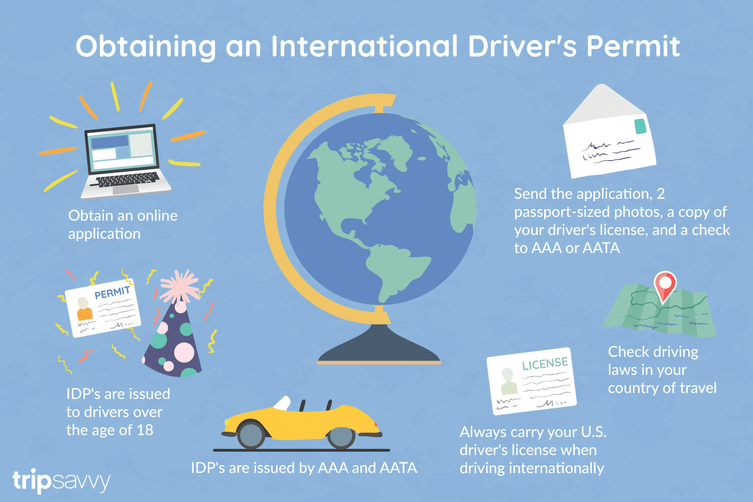
An International Driver's Permit (IDP) allows you to drive a vehicle in another country, as long as you also have a valid driver's license issued by your state. It is also recognized as a proper form of identification in over 175 countries and by many major car rental companies internationally.
Getting an International Driver's Permit (sometimes incorrectly called an international driver's license) can take anywhere from a day to a few weeks, depending on whether you're going through walk-in processing or applying via mail, so make sure to plan ahead if you're planning to drive on your international trip. There are only two locations in the United States that issue these documents: The American Automobile Association (AAA) and the American Automobile Touring Alliance (AATA).
In the United States, International Driver Permits (IDPs) are only issued by the American Automobile Association and the American Automobile Touring Alliance, and the State Department recommends against purchasing an IDP from other outlets as they are all entirely illegal to buy, carry, or sell.
IDPs can be issued to anyone over 18 who has had a valid driver's license for six months or longer. They typically remain valid for one year or the expiration of your existing state driving license. It's essential to investigate an IDP before your trip and make sure you know the requirements.
Both AAA and AATA are excellent sources for these documents, so once you've selected a provider, go to either the AAA's or NAATA's website, print out the International Driving Permit Application, complete all applicable fields, and submit it.
Once you have the application completed, you can send it in via the mail or visit a local office of an organization like AAA; you'll also need two original passport-sized photos and a signed copy of your valid U.S. driver's license as well as an enclosed check for the fee.
Tips to Getting and Using Your Permit
AAA offices can process IDPs during your visit, but processing generally takes 10 to 15 business days if you send the application in. However, expedited services may be available to get your license within one or two business days for an additional fee.
When applying, you'll need a computer and printer, a completed application, a copy of your valid U.S. driver's license, two passport photos, and a check, money order, or credit card to complete the process. Remember to bring these with you if you're applying in person.
Always make sure to carry your valid United States driver's license when driving internationally, as your IDP is invalid without this accompanying proof of eligibility to drive. IDPs only translate domestically-accepted licenses and do not allow those without government-issued driver's licenses to drive abroad.
You'll also want to make sure to enclose the proper fees (the fee for the IDP, as well as any shipping and handling fees), photos, and photocopies of your license when submitting your application to AAA or AATA as omitting any of these required documents will result in your application being rejected.
You should also check the driving requirements and laws for the countries you will be driving in on your vacation, so you'll know what will be required in the event you get stopped by local authorities. (Quelle:https://www.tripsavvy.com/)
 Medizin, Pharma, Rehabilitation
Medizinische Hochschulen/Medical colleges/Forschungsinstitut/Research Institute
Medizin, Pharma, Rehabilitation
Medizinische Hochschulen/Medical colleges/Forschungsinstitut/Research Institute


Der Bahnhof Haydarpaşa oder Bahnhof Haydarpascha, auch kurz Haydarpaşa genannt, ist der Hauptbahnhof Istanbuls für die asiatischen, östlichen Strecken.Der ehemalige Kopfbahnhof liegt auf der asiatischen Seite des Bosporus, innerhalb des Hafengeländes Haydarpaşa. Nördlich des Personenbahnhofes befindet sich der kombinierte Güter- und Hafenbahnhof. Der Bahnhof Haydarpaşa war eine Zwischenstation der Bosporusfähren Eminönü–Kadıköy und Karaköy-Kadıköy.
海达尔帕夏车站(土耳其语:Haydarpaşa Garı)是土耳其最大城市伊斯坦布尔的两个主要火车站之一,位于博斯普鲁斯海峡以东。始建于1872年,目前建筑1909年启用。
是伊斯坦布尔-安卡拉干线的西部终点站,也是巴格达铁路和希贾兹铁路的终点站。有火车渡轮横跨海峡到达欧洲一方的锡尔凯吉车站。


 Geographie

Das Schwarze Meer ist ein zwischen Südosteuropa, Osteuropa und Vorderasien gelegenes Binnenmeer, das über den Bosporus und die Dardanellen mit dem östlichen Mittelmeer verbunden ist. Es ist bis 2212 m tief[1] und hat (ohne das Asowsche Meer) eine Fläche von etwa 436.400 km².[2] Der Rauminhalt des Schwarzen Meeres beträgt 547.000 km³. Die durchschnittliche Wassertiefe beträgt 1253 Meter.
黑海是欧亚大陆的一个陆间海,被欧洲、高加索和安那托利亚半岛所包围[4]。黑海通过土耳其海峡与地中海的爱琴海区域相联。西亚和东欧被这一系列水体分隔开来。黑海在北面通过刻赤海峡与亚速海相连。流入黑海的主要河流有多瑙河和第聂伯河。沿海国家有土耳其、保加利亚、罗马尼亚、乌克兰、俄罗斯和格鲁吉亚。沿海重要城市有伊斯坦布尔、布尔加斯、瓦尔纳、康斯坦察、图尔恰、敖德萨、塞瓦斯托波尔、巴统等。
黑海的面积有436,400平方千米(168,500平方英里)(不包括亚速海)[1],最大深度为2,212米(7,257英尺)[2],体积为547,000立方千米(131,200立方英里)。[3]黑海形成一个东西向的椭圆形凹陷。[5]黑海的南面是本廷山脉,东面是高加索山脉,西北面是宽阔的低地。黑海东西向最宽有大约1,175千米(730英里)。
黒海(こっかい)は、ヨーロッパとアジアの間にある内海で、大西洋の縁海(地中海 (海洋学))の一つである。マルマラ海を経てエーゲ海、地中海に繋がる。
バルカン半島、アナトリア半島、コーカサスと南ウクライナ・クリミア半島に囲まれており、ドナウ川、ドニエストル川、ドニエプル川などの東ヨーロッパの大河が注ぐ。アナトリアとバルカンの間のボスポラス海峡、マルマラ海、ダーダネルス海峡を通じて地中海に繋がっており、クリミアの東にはケルチ海峡を隔ててアゾフ海がある。
黒海に面する国は、南岸がトルコで、そこから時計回りにブルガリア、ルーマニア、ウクライナ、ロシア、ジョージアである。
黒海に面する有名な港湾には、イスタンブール(ビュザンティオン、コンスタンティノープル)から時計回りにブルガス、ヴァルナ、コンスタンツァ、オデッサ、セヴァストポリ、ヤルタ、ガグラ、バトゥミ、トラブゾン、サムスンなどがある。
The Black Sea is a body of water and marginal sea of the Atlantic Ocean between the Balkans, Eastern Europe, the Caucasus, and Western Asia.[1] It is supplied by a number of major rivers, such as the Danube, Dnieper, Southern Bug, Dniester, Don, and the Rioni. About a third of Europe drains into the Black Sea,[2] including the countries of Austria, Belarus, Bosnia and Herzegovina, Bulgaria, Croatia, Czech Republic, Georgia, Germany, Hungary, Moldova, Poland, Romania, Russia, Serbia, Slovakia, Slovenia, Turkey and Ukraine.
The Black Sea has an area of 436,400 km2 (168,500 sq mi) (not including the Sea of Azov),[3] a maximum depth of 2,212 m (7,257 ft),[4] and a volume of 547,000 km3 (131,000 cu mi).[5] It is constrained by the Pontic Mountains to the south, Caucasus Mountains to the east, Crimean Mountains to the north, Strandzha to the southwest, Dobrogea Plateau to the northwest, and features a wide shelf to the northwest.
The longest East-West extent is about 1,175 km (730 mi).[6]
Important cities along the coast include Batumi, Burgas, Constanța, Giresun, Istanbul, Kerch, Novorossiysk, Odessa, Ordu, Poti, Rize, Samsun, Sevastopol, Sochi, Sukhumi, Trabzon, Varna, Yalta, and Zonguldak.
The Black Sea has a positive water balance; that is, a net outflow of water 300 km3 (72 cu mi) per year through the Bosphorus and the Dardanelles into the Aegean Sea. Mediterranean water flows into the Black Sea as part of a two-way hydrological exchange. The Black Sea outflow is cooler and less saline, and floats over the warm, more saline Mediterranean inflow – as a result of differences in density caused by differences in salinity – leading to a significant anoxic layer well below the surface waters. The Black Sea drains into the Mediterranean Sea, via the Aegean Sea and various straits, and is navigable to the Atlantic Ocean. The Bosphorus Strait connects it to the Sea of Marmara, and the Strait of the Dardanelles connects that sea to the Aegean Sea region of the Mediterranean. These waters separate Eastern Europe, the Caucasus and Western Asia. The Black Sea is also connected, to the North, to the Sea of Azov by the Strait of Kerch.
The water level has varied significantly. Due to these variations in the water level in the basin, the surrounding shelf and associated aprons have sometimes been land. At certain critical water levels it is possible for connections with surrounding water bodies to become established. It is through the most active of these connective routes, the Turkish Straits, that the Black Sea joins the world ocean. When this hydrological link is not present, the Black Sea is an endorheic basin, operating independently of the global ocean system, like the Caspian Sea for example. Currently the Black Sea water level is relatively high, thus water is being exchanged with the Mediterranean. The Turkish Straits connect the Black Sea with the Aegean Sea, and comprise the Bosphorus, the Sea of Marmara and the Dardanelles.
La mer Noire est située entre l’Europe, le Caucase et l’Anatolie. Large d'environ 1 150 km d’ouest en est et de 600 km du nord au sud, elle s’étend sur une superficie de 413 000 km2. L'adjectif correspondant est « pontique », qui vient du nom antique de cette mer, le Pont Euxin.
Le terme océanographique d'« euxinisme » y fait également référence, il désigne une anoxie des eaux profondes, plus salées qu'en surface et provenant de la Méditerranée via la mer de Marmara par un courant de fond inverse de celui des eaux plus douces de la surface alimentées par les fleuves se jetant dans la mer Noire.
Elle communique au sud-ouest avec la mer Méditerranée par le Bosphore, la mer de Marmara et le détroit des Dardanelles. Sur ses côtes ouest et nord, elle communique avec de nombreux limans (lagunes navigables dont la salinité et la turbidité varient avec la saison, et qui servaient de frayères pour le poisson). Au nord-est, la mer d'Azov, reliée par le détroit de Kertch, est considérée comme le plus grand des limans. Son climat spécifique doux et humide, aux épais brouillards aux saisons intermédiaires, subit des influences méditerranéennes au sud-ouest et en été (chaud, sec et ensoleillé), continentales au nord et en hiver (froid glacial, la mer peut geler, les chutes de neige sont fréquentes), et subtropicales au sud-est. Pendant les tempêtes, surtout hivernales, les vagues sont courtes, mais hautes, et peuvent venir de plusieurs directions à la fois, rendant la navigation difficile.
Depuis 1996, le 31 octobre est la « journée internationale pour la protection de la mer Noire »1.
Il Mar Nero (in ucraino: Чорне море? Čorne more; in russo: Чёрное море? Čiornoje morie; in bulgaro: Черно море? Černo more; in rumeno: Marea Neagră; in turco: Karadeniz, in georgiano: შავი ზღვა, Shavi zghva, in greco moderno: Μαύρη Θάλασσα, Mávri Thálassa) è un mare situato tra l'Europa sud-orientale e l'Asia minore. È collegato al Mar d'Azov tramite lo stretto di Kerč e, tramite il Bosforo, al Mare di Marmara, che a sua volta, tramite lo stretto dei Dardanelli, è collegato con il mare Egeo che fa parte del Mediterraneo.
I flussi di acqua in ingresso, attraverso il Bosforo, sono di circa 200 km³ (200 miliardi di metri cubi) all'anno. Il suo bacino imbrifero è molto ampio (2 milioni di km²); dalle aree circostanti riceve acque dolci per un totale di circa 320 km³ all'anno. I fiumi più importanti che vi sfociano sono il Danubio, il Dnepr e il Buh Meridionale.
La sua superficie è pari a circa 436 400 km² (escludendo il Mar d'Azov)[1] con una salinità pari a circa il 17‰ (poco meno della metà della salinità media del Mare Mediterraneo). In profondità, oltre i 150 m, questo valore aumenta drasticamente. Il punto più profondo si trova a 2 212 m, mentre nel centro la profondità è di circa 1 830 m. [2]
El mar Negro es un mar interior ubicado entre Europa oriental y Asia occidental. Se encuentra encerrado entre los Balcanes, la estepa póntica, Crimea, el Cáucaso y la península de Anatolia. El estrecho del Bósforo lo conecta con el pequeño mar de Mármara, y el estrecho de los Dardanelos conecta al anterior mar con el mar Egeo, que es una división del mar Mediterráneo. También está conectado con el mar de Azov, situado al noreste, por el estrecho de Kerch. El mar Negro forma una depresión elíptica con una pendiente de este a oeste, y tiene una superficie de 436 400 km2 (sin incluir el mar de Azov),1 una profundidad máxima de 2212 m2 y un volumen de 547 000 km3.3 Los países ribereños del mar Negro son, empezando por el sur y en sentido horario, Turquía, Bulgaria, Rumania, Ucrania, Rusia y Georgia.4
Está delimitado por los montes Pónticos al sur y por las montañas del Cáucaso al este, y cuenta con una amplia meseta al noreste. Su mayor longitud de este a oeste es de 1 175 km. Entre las ciudades importantes de sus costas están: Batumi, Burgas, Constanza, Giresun, Hopa, Estambul, Kerch, Mangalia, Năvodari, Novorossiysk, Odesa, Ordu, Poti, Rize, Sinope, Samsun, Sevastopol, Sochi, Sozopol, Sujumi, Trabzon, Varna, Yalta y Zonguldak.
Existe una salida neta de agua de 300 km3 al año a través del Bósforo y del estrecho de Dardanelos hacia el mar Egeo, mientras que el agua del Mediterráneo discurre hacia el mar Negro como parte de un camino de ida y vuelta de intercambio hidrológico. El flujo que sale del mar Negro es más frío y menos salino, y el flujo que entra desde el Mediterráneo es más cálido y salino, por lo que este flujo es el resultado de los cambios de densidad causados por la diferente salinidad, lo que da lugar a una gran cantidad de agua anóxica a 150 m bajo la superficie, que tienen la particularidad de descomponer los barcos hundidos fabricados en hierro pero no así los barcos de madera.5 El mar Negro también recibe agua del gran sistema fluvial de Eurasia por el norte del mar. Los ríos que le aportan más agua son el Danubio, el Dniéster, el Dniéper y el Don.
Los niveles de agua de este mar han variado significativamente a lo largo de la historia. Debido a estas variaciones del nivel del agua en la cuenca, los límites actuales de este mar han sido a veces terrazas geológicas secas. Cuando se dan determinados niveles de agua elevados es posible que el mar se conecte con otras aguas cercanas para estabilizarse. Es a través de una de estas rutas de conexión más activas, el estrecho turco, donde este mar se conecta con los océanos del mundo. Cuando este enlace hidrológico no está presente, el mar Negro se transforma en una cuenca endorreica que opera de forma independiente del sistema global de los océanos, como es el caso del mar Caspio. El estrecho turco conecta el mar Negro con el Egeo, y abarca el Bósforo, el mar de Mármara y el estrecho de Dardanelos.
Чёрное мо́ре — внутреннее море бассейна Атлантического океана. Проливом Босфор соединяется с Мраморным морем, далее, через пролив Дарданеллы (эти проливы зачастую называют Черноморскими проливами) — с Эгейским и Средиземным морями. Керченским проливом соединяется с Азовским морем. С севера в море глубоко врезается Крымский полуостров. По поверхности Чёрного моря проходит водная граница между Европой и Азией.
Площадь Чёрного моря — 422 000 км²[1] (по другим данным — 436 400 км²[2]). Очертания Чёрного моря напоминают овал с наибольшей осью около 1150 км. Наибольшая протяжённость моря с севера на юг — 580 км. Наибольшая глубина — 2210 м[1], средняя — 1240 м. Объём воды в море составляет 555 тыс. км³[3]. Характерной особенностью Чёрного моря является полное (за исключением ряда анаэробных бактерий) отсутствие жизни на глубинах более 150—200 м из-за насыщенности глубинных слоёв воды сероводородом.
Море омывает берега России, Украины, Румынии, Болгарии, Турции, Грузии, Абхазии[4] (территории, расположенные вокруг моря, традиционно именуют термином «Причерноморье»).
Чёрное море — важный район транспортных перевозок. Помимо этого, Чёрное море сохраняет важное стратегическое и военное значение. В Севастополе и Новороссийске находятся основные военные базы российского Черноморского флота, в Синопе и Самсуне базируются корабли черноморской группировки ВМФ Турции, в Варне — ВМС Болгарии, в Поти и Батуми — корабельный состав департамента береговой охраны Пограничной полиции Грузии[5], в Констанце и Мангалии — ВМС Румынии. До марта 2014 года в Севастополе и Новоозёрном базировались части Военно-морских сил Украины, после присоединения Крыма к России переместившиеся в Одессу.
 Finanz
Albanien
Armenien
Aserbaidschan
Bulgarien
Georgien
Griechenland
Moldawien
Rumänien
Russland
Türkei
Ukraine
Finanz
Albanien
Armenien
Aserbaidschan
Bulgarien
Georgien
Griechenland
Moldawien
Rumänien
Russland
Türkei
Ukraine

Die Black Sea Trade and Development Bank (BSTDB, dt, Schwarzmeer-Handels- und Entwicklungsbank) ist eine internationale Entwicklungsbank im Dienst der elf Gründungsmitglieder der Schwarzmeer-Wirtschaftskooperation, einer regionalen Wirtschaftsorganisation. Sie unterstützt die wirtschaftliche Entwicklung und die regionale Zusammenarbeit durch die Bereitstellung von Darlehen, Garantien und Eigenkapital für Entwicklungsprojekte und Handelsgeschäfte. Die BSTDB unterstützt sowohl öffentliche als auch private Unternehmen in den Mitgliedsländern und knüpft ihre Finanzierungen nicht an politische Bedingungen[2].
Zu den Zielen der Bank gehören die Förderung regionaler Handelsbeziehungen, länderübergreifender Projekte und ausländischer Direktinvestitionen sowie die Unterstützung von Aktivitäten, die zur nachhaltigen Entwicklung beitragen, wobei der Schwerpunkt auf der Schaffung von Arbeitsplätzen in den Mitgliedsländern liegt[3]. Die Bank verfügt über ein genehmigtes Kapital von 3,45 Mrd. EUR[4].
黑海贸易和开发银行(BSTDB)是一家国际开发银行,为区域经济组织黑海经济合作组织的 11 个创始成员提供服务。它通过为发展项目和贸易交易提供贷款、担保和股权来支持经济发展和区域合作。黑海经济合作银行为成员国的公共和私营公司提供支持,对其融资不附加任何政治条件。
 Sport
Sport

 Internationale Städte
Gaziantep (arabisch عينتاب, DMG ʿAyintāb oder عنتاب / ʿAntāb, armenisch Այնթա Aynt’ap, kurdisch Entep bzw. Dîlok), auch kurz Antep genannt, ist eine Stadt in Südostanatolien und Hauptstadt der gleichnamigen Provinz. Mit etwa 2,1 Mio. Einwohnern (Stand 2019) ist sie die sechstgrößte Stadt der Türkei. Neben Türken und Kurden leben auch Araber in Gaziantep.
加济安泰普(Gaziantep),又名安泰普,是土耳其的一座城市,也是仍有人居住的世界上最古老的城市之一,可追溯到前3650年[2]。截至2010年,加济安泰普的城市圈范围包括整个加济安泰普省,人口达到130万,由此也成为土耳其第六大城市。
Türkei
UEFA Champions League 2015/16
UEFA Champions League 2018/19
Gruppe D
UEFA Champions League 2019/20
Gruppe A