
Deutsch-Chinesische Enzyklopädie, 德汉百科
 Serbia

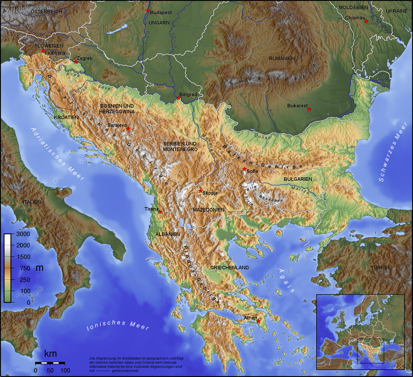
Das Balkangebirge, kurz auch Balkan (kyrillisch Балкан), bulgarisch und serbisch Stara Planina (kyrillisch Стара планина), ist ein tertiäres Faltengebirge in Südosteuropa, dessen Hauptkamm in Bulgarien liegt. Es ist Teil des Alpidischen Gebirgssystems. Nach dem Gebirge wurde die Balkanhalbinsel benannt.
Auf dem Gebiet wurden ein Nationalpark, vier Naturparks (Sinite Kamani, Balgarka, Wratschanski Balkan und Stara Planina) sowie etliche Naturreservate und Schutzgebiete zum Schutze der Flora und Fauna eingerichtet.
 Albania
 Bosnia Herzegovina
 Bulgaria
 Greece
 Kosovo
 Croatia
 Montenegro
 Nordmazedonien
 Romania
 Serbia
 Slovenia
 Turkey
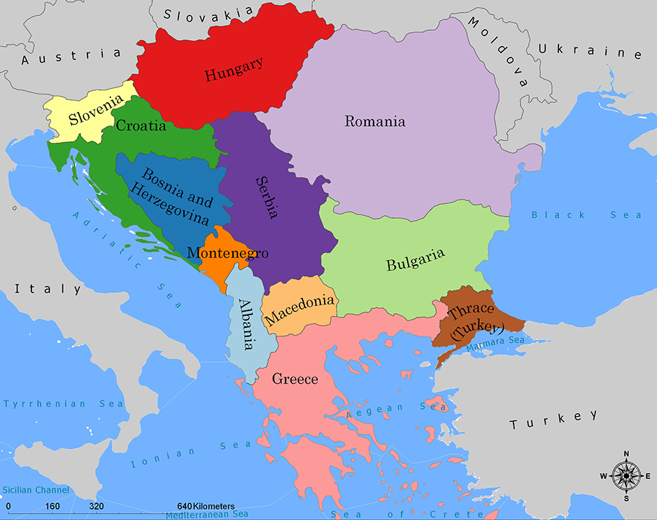
巴尔干半岛(Balkans),是一个地理名词,用以描述欧洲的东南隅位于亚得里亚海和黑海之间的陆地,详细的范围依照定义不同有许多种说法。该地约有55万平方公里和近5500万人口。在古希腊时代,巴尔干半岛被称为哈伊莫司半岛。该地区的名称来自于一条通过保加利亚中心到东塞尔维亚的巴尔干山脉。[1]
巴尔干地区向来存在诸多矛盾,其中既有宗教矛盾,也有领土争端。由于半岛的地缘政治重要性,由此而来的列强干涉致使这一地区的矛盾频繁被放大为战争,因此又有欧洲火药库之称。不过近年巴尔干半岛(南斯拉夫内战后至今)已实现停火与和平,只是偶然间在领土主权上有些纠纷,例如科索沃主权问题。第一次世界大战的触发点之——萨拉热窝事件亦是发生在巴尔干半岛上。
目前,巴尔干半岛共有11个国家,共有面积是47.6万平方公里,人口1.3亿。
南欧相邻地中海的三大半岛,从东向西分别为巴尔干半岛、意大利半岛(亚平宁半岛)、伊比利亚半岛。
半岛地处欧、亚、非三大陆之间,是欧、亚联系的陆桥,南临地中海重要航线,东有博斯普鲁斯海峡和达达尼尔海峡扼黑海的咽喉,地理位置极为重要。地形以山地为主,喀尔巴阡山以南多为山丘及石灰岩地形,以北多以为平原为主。半岛西部有迪纳拉-品都斯山脉,中东部有喀尔巴阡-老山(巴尔干)山脉。老山山脉是阿尔卑斯、喀尔巴阡山的延伸,经南斯拉夫东部,横贯保加利亚中部,直临黑海。东西两列山脉之间是古老的罗多彼山脉和马其顿山丛,最高峰穆萨拉峰,海拔2925米。半岛上平原分布零散,仅萨瓦河、多瑙河、马里查河谷较宽广。 巴尔干半岛位于欧洲东南部,三面被水环绕:西邻亚德里亚海、南面是地中海(包括爱奥尼亚海和爱琴海)和马尔马拉海、东边是黑海。其北部边界通常被定为多瑙河、萨瓦河和库帕河。[2] [3]巴尔干半岛包括49万平方公里土地。
Die Balkanhalbinsel (auch kurz Balkan, oft synonym mit Südosteuropa verwendet) ist eine geographisch nicht eindeutig definierte Halbinsel im Südosten Europas. Sie ragt in das Mittelmeer und ist nach dem Balkangebirge benannt. Der größte Staat auf der Halbinsel ist Griechenland, gefolgt von Bulgarien (in dem sich der Großteil des Balkangebirges befindet), Serbien, Bosnien und Herzegowina, Albanien, Nordmazedonien, Montenegro und dem Kosovo. Die Staatsgebiete von Serbien, Kroatien, Rumänien, Slowenien und der Türkei, die durch ihre thrakischen Provinzen Anteil am Balkan hat, reichen über die Grenzen der Balkanhalbinsel hinaus.
Ungeachtet der Herleitung des geographischen Namens sind das dominierende Gebirge des Balkans die Dinariden im westlichen Teil der Halbinsel; ihr höchster Gipfel Jezerca (2694 m) liegt in Albanien. Die höchste Erhebung des Balkans ist der Gipfel Musala (2925 m) im Rila-Gebirge. Das Balkangebirge erreicht 2376 m maximale Gipfelhöhe.
バルカン半島(バルカンはんとう、Balkan Peninsula)、またはバルカン(Balkans)は東南ヨーロッパにある地理的領域であり、地理的・歴史的に様々な意味合いと定義付け[1][2]の下で使用される概念である[3]。名称はバルカン山脈からきている。この山脈はセルビアとブルガリアの国境から黒海沿岸まで、ブルガリア全土を横断している。バルカン半島は北西をアドリア海に、南西をイオニア海に、南と南東をエーゲ海に、そして東と北東を黒海によって区切られている[4]。北側の境界は論者と文脈によって様々に定義されていて不定である。バルカン半島の最高地点はリラ山地にあるムサラ山(2925メートル)である。
バルカン半島という概念はドイツの地理学者アウグスト・ツォイネによって1808年に創り出された[5][6]。彼はバルカン山脈がディナル・アルプス山脈と共にアドリア海から黒海まで東南ヨーロッパを区分していると誤認していた[5]。この地域はかつてオスマン帝国の属領であり、バルカン半島という用語は19世紀にはヨーロッパ・トルコ(European Turkey)の同義語であった[7]。バルカン半島という言葉は地理学的というよりもむしろ地政学的定義を持っており、この傾向は20世紀初頭にユーゴスラヴィア王国が成立するとさらに増した。バルカン半島を定義する自然境界が「半島」の学術的定義と一致していないため、現代の地理学者は「バルカン半島」という考え方を拒絶しており、通常はバルカンを「地域」として議論を行っている。この言葉には徐々に、特に1990年代以降、バルカニゼーション(バルカン化)のプロセスと関連して汚名と侮蔑的意味合いが与えられており[4][8]、それ故に東南ヨーロッパ(南東ヨーロッパ)という別の用語が使用されている。
The Balkans (/ˈbɔːlkənz/ BAWL-kənz), also known as the Balkan Peninsula, is a geographic area in Southeast Europe with various geographical and historical definitions.[2][3][4] The region takes its name from the Balkan Mountains that stretch throughout the whole of Bulgaria. The Balkan Peninsula is bordered by the Adriatic Sea in the northwest, the Ionian Sea in the southwest, the Aegean Sea in the south, the Turkish Straits in the east, and the Black Sea in the northeast. The northern border of the peninsula is variously defined.[5] The highest point of the Balkans is Mount Musala, 2,925 metres (9,596 ft), in the Rila mountain range, Bulgaria.
The concept of the Balkan Peninsula was created by the German geographer August Zeune in 1808,[6] who mistakenly considered the Balkan Mountains the dominant mountain system of Southeast Europe spanning from the Adriatic Sea to the Black Sea. The term Balkan Peninsula was a synonym for Rumelia in the 19th century, the European provinces of the Ottoman Empire. It had a geopolitical rather than a geographical definition, which was further promoted during the creation of the Kingdom of Yugoslavia in the early 20th century. The definition of the Balkan Peninsula's natural borders do not coincide with the technical definition of a peninsula; hence modern geographers reject the idea of a Balkan peninsula, while historical scholars usually discuss the Balkans as a region. The term has acquired a stigmatized and pejorative meaning related to the process of Balkanization,[5][7] and hence the preferred alternative term used for the region is Southeast Europe.
Les Balkans sont une des trois « péninsules » de l'Europe du Sud, mais cette appellation traditionnelle est parfois contestée en l'absence d'un isthme : les géographes préfèrent le terme de « région ». Elle est bordée par des mers sur trois côtés : la mer Adriatique et la mer Ionienne à l'ouest, la mer Égée au sud et la mer de Marmara et la mer Noire à l'est. Au nord, on la délimite généralement par les cours du Danube, de la Save et de la Kupa. Cette région couvre une aire totale de plus de 550 000 km2 et regroupe une population de près de 53 millions d’habitants.
La penisola balcanica, nota anche come Balcani (dalla forma abbreviata di Monti Balcani, sistema montuoso tra Bulgaria e Serbia; dal turco balkan ‘monteʼ[2]), è una penisola dell'Europa orientale; è delimitata a ovest dal mare Adriatico, a sud-ovest dal mar Ionio, a est dal mar Nero, a sud-est dal mar di Marmara, e a sud dal mar Egeo.
Come spesso accade per le penisole, incerta è la definizione del suo confine sulla terraferma, aggravato dal fatto che si tratta di uno dei suoi confini più estesi. Non aiuta inoltre la definizione di questa linea di demarcazione il fatto che il territorio presenta al suo interno grandi differenze e frammentazioni per storia, nazionalità, lingua, cultura e religione delle popolazioni che vi abitano.
Solitamente se ne stabilisce il confine sul Danubio e sul suo affluente Sava. In questo modo si include in tale area anche parte della Slovenia e della Romania (paese di lingua romanza orientale), che però storicamente hanno avuto a che fare con i Balcani solo dopo la dissoluzione dell'Impero asburgico. Secondo il geografo Vittorio Vialli, la delimitazione a nord è rappresentata dalla linea geografica Istria-Odessa. Esclude dalla regione la Slovenia l'interpretazione del confine che include il fiume Kupa, facendolo partire dalla città di Fiume e raggiungendo le foci del Danubio.[3] In tal modo confina a ovest con la cosiddetta regione geografica italiana,[4][5] che include anche territori non facenti parte della Repubblica Italiana. La definizione politica di Balcani venne in uso nel XIX secolo per designare i paesi europei interessati dall'espansione e dalla successiva dissoluzione dell'Impero ottomano.[6]
Del resto le caratteristiche del territorio, solcato da catene montuose parallele che ostacolarono il movimento in direzione nord-sud e una colonizzazione uniforme già ai tempi dell'espansione greco-romana, e la sua stessa collocazione geografica contribuiscono a spiegare le tormentate vicende storiche che hanno caratterizzato la penisola.[7]
Fino al 1975 la penisola era attraversata dal Balkan Express, un treno con partenza da Vienna e arrivo a Istanbul. Il clima è continentale nel nord e nell’est del territorio (con estati calde e inverni molto rigidi), mentre l’area occidentale e la Grecia hanno un clima mediterraneo.
La península balcánica o península de los Balcanes es una de las tres grandes penínsulas del sur de Europa, continente al que está unida por los montes Balcanes al este (cordilleras que han dado nombre a la península) y los Alpes Dináricos, al oeste.
Балка́нский полуо́стров (хорв. Balkanski poluotok, словен. Balkanski polotok, серб. Балканско полуострво, рум. Peninsula Balcanică, болг. и макед. Балкански полуостров, алб. Gadishulli Ballkanik, греч. Βαλκανική χερσόνησος, тур. Balkan Yarımadası, босн. Balkansko poluostrvo, черног. Balkansko poluostrvo) расположен на юго-востоке Европы. Площадь — около 467 тыс. км².
С юга, юго-запада и юго-востока омывается: Адриатическим, Ионическим, Мраморным, Критским, Эгейским и Чёрным морями.
Северной границей полуострова считается условная линия, проведённая от устья Дуная, по рекам Дунай, Сава и Купа (Колпа), а от истока последней в Горском Котаре (Хорватия) — до залива Кварнер с портом Риека (Хорватия).
Рельеф преимущественно гористый (Стара-Планина, Родопы, Динарское нагорье, Пинд). По размерам в Европе уступает только Скандинавскому и Пиренейскому полуостровам.
 Albania
 Bosnia Herzegovina
 Bulgaria
 Greece
 Kosovo
 Croatia
 Montenegro
 Nordmazedonien
 Romania
 Serbia
 Slovenia
 Turkey

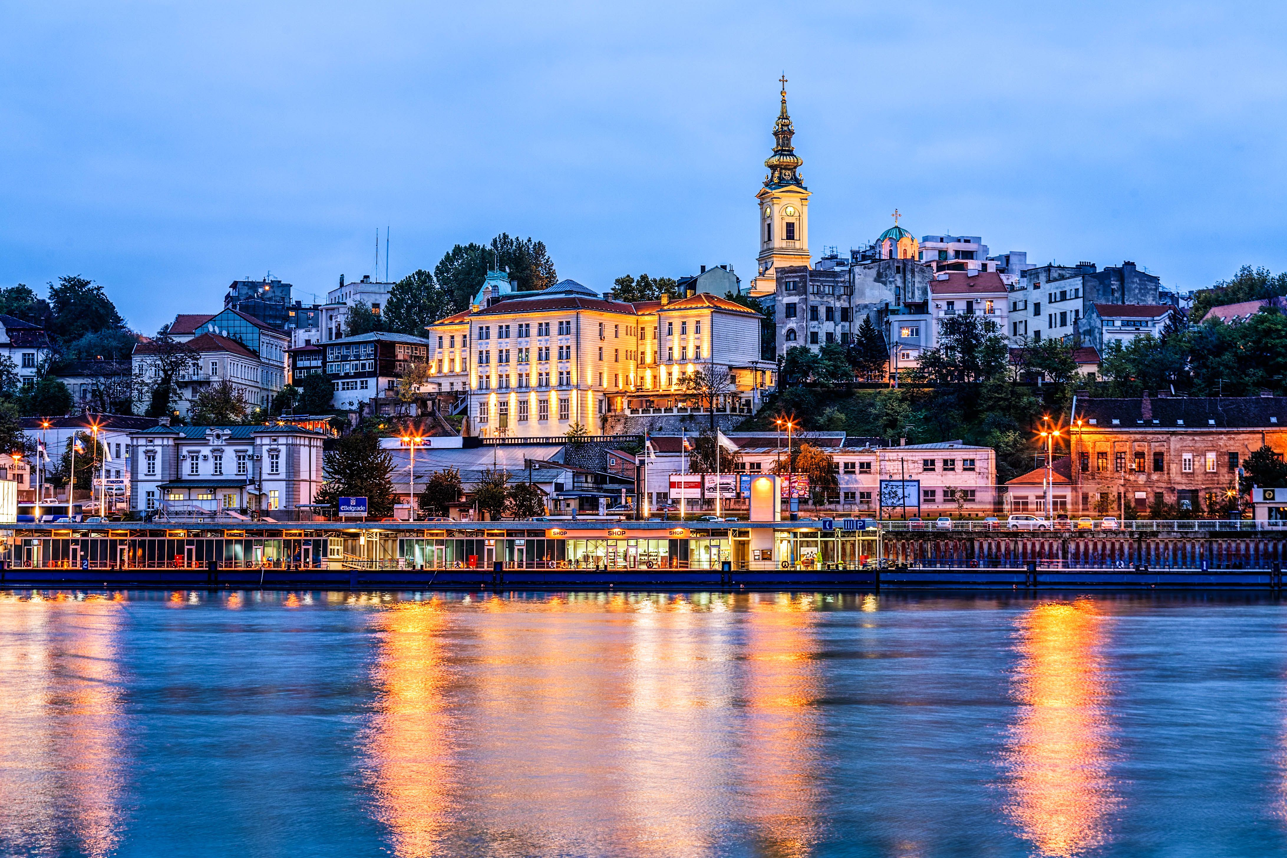
贝尔格莱德(塞尔维亚语:Београд,意为“白城”),欧洲国家塞尔维亚首都和最大城市,以及当年南斯拉夫联邦时期的总首都。贝尔格莱德市位于塞尔维亚北部萨瓦河和多瑙河汇合处,此处也是潘诺尼亚平原和巴尔干半岛的相遇处。贝尔格莱德市内共有人口123万,整个行政区范围内的人口达到近170万,是原南斯拉夫地区最大的城市。
贝尔格莱德地区最早的人类居住出现在公元前4800年温查文明时期。凯尔特人于公元前3世纪征服了这一地区,并将其命名为Singidunum,[5] 后被罗马帝国占领[6] [7]。
公元520年,斯拉夫人占领了这一地区。此后它在拜占庭帝国、法兰克王国、保加利亚王国和奥匈帝国之间几次易手。城市的斯拉夫语名字Beligrad(字面意思为“白城”)第一次被提及是在878年。1284年,贝尔格莱德第一次成为塞尔维亚斯雷姆王国的首都。此后,它还先后成为塞尔维亚(1404年-1918年、2006年-)、南斯拉夫(1918年-2003年)首都以及塞尔维亚和黑山的行政、立法首都(2003年-2006年)[8]。
贝尔格莱德是塞尔维亚唯一的直辖市[9],被分为17个自治市,每一个都拥有自己的地方委员会[10]。贝尔格莱德占塞尔维亚总面积的3.6%,约21%(不包括科索沃自治省)的塞尔维亚人居住在该市[11]。贝尔格莱德是塞尔维亚的经济、文化、教育和科技中心。
Belgrad (serbisch Београд/Beograd [], übersetzt „weiße Stadt“, daher der altertümliche Name Griechisch Weißenburg), ist die Hauptstadt der Republik Serbien. Die Stadt gliedert sich in zehn Stadtgemeinden und sieben Vorstadtgemeinden. Die Kernstadt besitzt eine Fläche von 359,96 km², die umgebenden Vorstadtgebiete 2862,72 km², wobei die Fläche einiger Gemeinden teilweise zur Kernstadt und teilweise zur Vorstadt gehört. Zusammen bilden sie den Okrug Beograd mit 1,71 Millionen Einwohnern (Zensus 2011) und gehört somit zu den größten Metropolregionen in Südosteuropa. Mit 1.233.796 Einwohnern[1] ist sie außerdem die serbische Primatstadt.
Mit seinen Universitäten, Hochschulen und wissenschaftlichen Einrichtungen stellt Belgrad das überragende Bildungszentrum und mit zahlreichen Verlagen, Rundfunk- und Fernsehanstalten sowie Tages- und Monatszeitungen auch das dominierende Medienzentrum des Landes. Belgrad ist Sitz der Serbisch-Orthodoxen Kirche und Residenz des Serbischen Patriarchen. Das größte christliche Gotteshaus der Balkanhalbinsel, die Kathedrale Hl. Sava, steht in Belgrad.
Dank der Lage an der Mündung der Save in die Donau am südöstlichen Rand der Pannonischen Tiefebene und an der Nordgrenze der Balkanhalbinsel ist die Stadt Dreh- und Angelpunkt für den Verkehr zwischen Mittel- und Südosteuropa. In der regionalen Vernetzung der Verkehrswege ist es Sitz des Sekretariats für Transport der Länder im Westbalkan.[2][3] Daher wird Belgrad oft auch als Tor zum Balkan bezeichnet. Wahrzeichen Belgrads ist die in der Geschichte häufig umkämpfte, über der Save-Mündung in die Donau thronende Festung von Belgrad. In der Nähe befindet sich die historische Universitäts-Sternwarte und jenseits des Flusses (Novi Beograd) das 1977–1979 erbaute Sava Centar, das größte Kongresszentrum aller Balkanländer.
Belgrad war erstmals zu Anfang des 15. Jahrhunderts Hauptstadt der mittelalterlichen Serbischen Herrscherdynastien und ist seit dem 19. Jahrhundert Residenzstadt Serbiens. Im 20. Jahrhundert war es die Hauptstadt des Königreichs Jugoslawien und des sozialistischen Jugoslawien. Durch die jugoslawische Ablehnung sowjetischer Hegemonie und Stalinismus und als Versammlungsort der Blockfreien war Belgrad in der Zeit des Kalten Krieges ein bedeutendes politisches Zentrum.
Belgrade (/ˈbɛlɡreɪd/ BEL-grayd; Serbian: Beograd / Београд, meaning "white city", Serbian pronunciation: [beǒɡrad] (![]() listen); names in other languages) is the capital and largest city of Serbia. It is located at the confluence of the Sava and Danube rivers, where the Pannonian Plain meets the Balkans.[7] The urban area of the City of Belgrade has a population of 1.23 million, while nearly 1.7 million people live within its administrative limits.[5]
listen); names in other languages) is the capital and largest city of Serbia. It is located at the confluence of the Sava and Danube rivers, where the Pannonian Plain meets the Balkans.[7] The urban area of the City of Belgrade has a population of 1.23 million, while nearly 1.7 million people live within its administrative limits.[5]
One of the most important prehistoric cultures of Europe, the Vinča culture, evolved within the Belgrade area in the 6th millennium BC. In antiquity, Thraco-Dacians inhabited the region and after 279 BC Celts conquered the city, naming it Singidūn.[8] It was conquered by the Romans during the reign of Augustus, and awarded city rights in the mid-2nd century.[9] It was settled by the Slavs in the 520s, and changed hands several times between the Byzantine Empire, Frankish Empire, Bulgarian Empire and Kingdom of Hungary before it became the capital of Serbian king Stephen Dragutin (1282–1316). In 1521, Belgrade was conquered by the Ottoman Empire and became the seat of the Sanjak of Smederevo.[10] It frequently passed from Ottoman to Habsburg rule, which saw the destruction of most of the city during the Austro-Ottoman wars. Belgrade was again named the capital of Serbia in 1841. Northern Belgrade remained the southernmost Habsburg post until 1918, when the city was reunited. As a strategic location, the city was battled over in 115 wars and razed 44 times.[11] Belgrade was the capital of Yugoslavia from its creation in 1918.
Belgrade has a special administrative status within Serbia[12] and it is one of five statistical regions of Serbia. Its metropolitan territory is divided into 17 municipalities, each with its own local council.[13] The city of Belgrade covers 3.6% of Serbia's territory, and around 24% of the country's population lives within its administrative limits.[5] It is classified as a Beta-Global City.[14]
Belgrade (en serbe cyrillique : Београд ; en serbe latin : Beograd) est la capitale et la plus grande ville de Serbie. Au recensement de 2011, la ville intra muros comptait 1 233 796 habitants et, avec le district dont elle est le centre, appelé Ville de Belgrade (Град Београд/Grad Beograd), 1 659 440 habitants3.
Belgrade est l'une des plus anciennes cités d'Europe, avec une histoire qui s’étend sur plus de 7 000 ans. Selon les historiens, on évalue la destruction de la ville entre 28 et 33 fois, sa position stratégique en Europe étant son bonheur et son malheur, d'où les vers du XVe siècle de Constantin le philosophe, « Pleure ville blanche, le noir de tes deuils »4. Les premières traces de présence humaine dans la région remontent à la Préhistoire et à la culture de Vinča. Historiquement, Belgrade est l’antique cité de Singidunum, colonie romaine située dans la province de Mésie. Le nom slave Beograd apparaît pour la première fois le 16 avril 878, dans une épître envoyée par le pape Jean VIII au prince Boris Ier de Bulgarie. Il a pour signification la « ville blanche ». Au fil de son histoire mouvementée, Belgrade a été conquise par 40 armées : elle a été romaine qui l'a surnommé « La colline aux méditations »5, byzantine, hongroise, serbe, ottomane puis capitale de la Serbie officiellement indépendante de la Sublime Porte en 1878.
Aujourd'hui, Belgrade dispose d'un statut qui la dote d'une assemblée et d'un gouvernement particuliers, à l'instar des districts de Serbie6. Sa zone métropolitaine, appelée « district de Belgrade » ou « ville de Belgrade », est divisée en 17 municipalités qui possèdent toutes leur propre conseil local7. Le district de Belgrade couvre ainsi 3,6 % du territoire de la Serbie et abrite 21 % de la population du pays (hors Kosovo). Belgrade est le centre économique de la Serbie, mais aussi la capitale de la culture serbe et celui de l'éducation et des sciences du pays.
Belgrado (AFI: /belˈɡrado/[2][3]; in serbo Бeoгpaд, Beograd?) è la capitale della Serbia e, fino al 1992, della Jugoslavia.
Si trova nell'ex provincia della Serbia centrale, nel punto di confluenza tra i fiumi Sava e Danubio, dove il territorio della Penisola Balcanica incontra la Pannonia. È una delle città più antiche d'Europa.
Con una popolazione di 1.233.796 abitanti, quella di Belgrado è l'area metropolitana più popolata dell'ex Jugoslavia, nonché la terza nell'Europa sudorientale, dopo quelle di Atene e di Bucarest; l'estensione superficiale dell'area urbana occupa il 3,6% del territorio della Serbia e vi risiede il 21% della popolazione serba (escludendo quella della provincia del Kosovo[4]).
La città possiede uno status che le conferisce una maggiore autonomia rispetto agli altri centri urbani della Serbia. È divisa in 17 comuni[5], dotati anch'essi di una propria autonomia organizzativa[6]. Belgrado non solo è la capitale economica e finanziaria della Serbia, ma anche culturale e scientifica, ed è uno dei principali luoghi turistici della nazione.
Nel 4800 a.C. circa, nell'area dell'attuale città di Belgrado si sviluppò la cultura Starčevo. Il medesimo territorio fu occupato alcuni secoli dopo dal popolo dei Vinča. Nel III secolo a.C. i Celti fondarono un villaggio nella zona che oggi è il centro storico di Belgrado, che fu, successivamente, conquistato dai Romani, che gli diedero il nome di Singidunum. Dal IX al XVI secolo Singidunum fu, alternativamente, sotto il potere dei Bizantini, dei Bulgari, dei Magiari e dei Serbi. Nel 1521 gli Ottomani la conquistarono. Tra il XVII secolo e il XVIII secolo Belgrado fu più volte espugnata e perduta della Casa d'Asburgo. Dopo la definitiva liberazione, nel 1841, dal dominio turco, divenne la capitale del Principato di Serbia, che, nel 1882 fu rinominato Regno di Serbia. La città fu capitale della Jugoslavia dal 1918 al 1991.
Belgrado (en serbio: Beograd; la Ciudad Blanca; escrito en alfabeto cirílico: Беoград) es la capital de la República de Serbia, además de la ciudad más grande y poblada del territorio de la antigua Yugoslavia.
Situada en la confluencia del río Sava con el Danubio y en el límite de la Llanura Panónica con la Península Balcánica, Belgrado se extiende sobre una superficie de 3222,68 km², que ocupan el 3,6 % del territorio de la República. El área metropolitana alberga a una población de 1 756 534 habitantes3 que representa el 21 % de la población serbia,45 siendo por ello también la cuarta ciudad más poblada del sureste de Europa, después de Estambul, Atenas y Bucarest.
Belgrado dispone, de acuerdo a la Constitución serbia, de un estatus especial dentro de la organización territorial del país, por el que se articula la representación ciudadana mediante un sistema de gobierno autónomo dividido en varios cuerpos6 que son la Asamblea de la Ciudad, la Alcaldía y el Consejo, siendo cada uno de los 17 municipios en los que se divide administrado por un consejo propio.7
Como capital de Serbia, Belgrado es sede de los principales organismos e instituciones de su Estado, así como de las universidades y establecimientos de investigación más importantes. Es asimismo el motor económico del país, con un sector agrario singular, y principal centro para la difusión de la cultura de Serbia. Es una de las ciudades más antiguas de Europa, con una historia que se remonta a casi 7000 años, con frecuencia convulsionada al ser escenario de enfrentamientos entre las potencias que dominaron sucesivamente la región.
Los primeros asentamientos aparecieron con la cultura prehistórica de Vinča hacia el 4800 a. C. En el siglo III a. C. se asentaron los celtas, y más tarde, los romanos fundaron la ciudad de Singidunum.89 Los primeros documentos donde consta el nombre eslavo Beligrad datan del año 878. En 1284 pasa a manos de los serbios de Sirmia, y a partir de 1403, del Despotado de Serbia. Más tarde también fue capital del Principado de Serbia, convertido en Reino de Serbia en 1882, así como de las diferentes variaciones estatales de Yugoslavia entre 1918 y 2003, lo mismo que de la Confederación de Serbia y Montenegro hasta su disolución en 2006.10

 Belgium
 Breakthrough Prize
 Fundamental Physics Breakthrough Prize
 Bulgaria
 Denmark
 Germany
 Finland
 France
 Greece
 Israel
 Italy
Italy
 Netherlands
 Norwegen
 Austria
 Poland
 Portugal
 Romania
 Sweden
 Switzerland
 Genf
Genf
 Serbia
 Slovakia
 Spain
Spain
 Czech Republic
 Hungary
 United Kingdom

 Important International Organizations

 Science and technology
 *World famous research institutions

欧洲核子研究中心(法语:Organisation Européenne pour la Recherche Nucléaire;英文:European Organization for Nuclear Research,通常被简称为CERN ),是世界上最大的粒子物理学实验室,也是万维网的发祥地。它成立于1954年9月29日,总部位于瑞士日内瓦西北部郊区的法瑞边境上,享有治外法权。CERN目前有21个成员国。以色列是第一个也是目前唯一一个非欧洲成员国。
CERN也被用来称呼它的实验室,其主要功能是为高能物理学研究的需要,提供粒子加速器和其它基础设施,以进行许多国际合作的实验。同时也设立了资料处理能力很强的大型电脑中心,协助实验数据的分析,供其他地方的研究员使用,形成了一个庞大的网络中枢。
欧洲核子研究中心现在已经聘用大约三千名的全职员工。并有来自80个国籍的大约6500位科学家和工程师,代表500余所大学机构,在CERN进行试验。这大约占了世界上的粒子物理学圈子的一半。
粒子物理学博物馆欢迎一般公众在办公时间参观。除此之外,事前预约的话每天上下午共有两个时段可以参观实际的实验工作,并备有导览说明。导览员来自各国的实验合作者,可以提供多种语言的向导。
Das CERN, die Europäische Organisation für Kernforschung, ist eine Großforschungseinrichtung bei Meyrin im Kanton Genf in der Schweiz. Am CERN wird physikalische Grundlagenforschung betrieben, insbesondere wird mit Hilfe großer Teilchenbeschleuniger der Aufbau der Materie erforscht. Der derzeit bedeutendste ist der Large Hadron Collider, der 2008 in Betrieb genommen wurde.
Das Akronym CERN leitet sich vom französischen Namen des Rates ab, der mit der Gründung der Organisation beauftragt war, dem Conseil européen pour la recherche nucléaire. Die offiziellen Namen des CERN sind European Organization for Nuclear Research im Englischen beziehungsweise Organisation européenne pour la recherche nucléaire im Französischen.[1]
Derzeit hat das CERN 22 Mitgliedstaaten. Mit etwa 3.200 Mitarbeitern (Stand: 31. Dezember 2015)[2] ist das CERN das weltweit größte Forschungszentrum auf dem Gebiet der Teilchenphysik. Über 10.000 Gastwissenschaftler[2] aus 85 Nationen arbeiten an CERN-Experimenten. Das Jahresbudget des CERN belief sich 2014 auf ungefähr 1,11 Milliarden Schweizer Franken (ca. 1 Milliarde Euro).[3]
Das CERN ist außerdem der Geburtsort des World Wide Web.[4]
 Argentina
 Australia
 Germany
 France
 Italy
Italy
 Croatia
 Russia
 Sweden
 Switzerland
 Serbia
 Spain
Spain

 Sport
Sport

 Sport
Sport
 Tennis
 South Africa
 Czech Republic
 United States
 United Kingdom

Nationen nach Anzahl der Siege und FinalteilnahmenRangLandSiegeFinal-
| Rang | Land | Siege | Final- niederlagen |
|---|---|---|---|
| 1. | 32 | 29 | |
| 2. | 28* | 19 | |
| 3. | 10 | 9 | |
| 4. | 10 | 8 | |
| 5. | 7 | 5 | |
| 6. | 6 | 4 | |
| 7. | 3 | 3 | |
| 8. | 3 | 2 | |
| 3** | 2 | ||
| 10. | 2 | 2 | |
| 11. | 1 | 6 | |
| 12. | 1 | 4 | |
| 13. | 1 | 1 | |
| 1 | 1 | ||
| 15. | 1 | 0 | |
| 16. | 0 | 3 | |
| 0 | 3 | ||
| 0 | 3 | ||
| 19. | 0 | 1 | |
| 0 | 1 | ||
| 0 | 1 | ||
| 0 | 1 | ||
| 0 | 1 |
* inkl. vier Siegen als Australasien
** inkl. eines Sieges als Tschechoslowakei

Die Demokratska Stranka (DS), zu Deutsch ‚Demokratische Partei‘ (serbisch-kyrillisch Демократска странка), ist eine sozialdemokratische Partei in Serbien. Die DS tritt für die Parlamentarische Demokratie und für den Sozialstaat ein. Sie ist eine prowestliche und proeuropäische Partei, die Unabhängigkeit des Kosovo lehnt sie jedoch ab.
民主党(塞尔维亚语:Демократска странка/Demokratska stranka)是塞尔维亚的一个社会民主主义政党。它自称南斯拉夫王国时期民主党的继承者。
 Architecture
 Transport and traffic
 Geography
 International cities
 History
 Religion
 World Heritage
 Education and Research
 Party and government