
Deutsch-Chinesische Enzyklopädie, 德汉百科
 Cyprus

 *Mediterranean Sea
 Egypt
Egypt
 Albania
 Algeria
 Amber Road
 Bosnia Herzegovina
 France
 Gibraltar
 Greece
 Israel
 Italy
Italy
 Croatia
 Libanon
 Libya
Libya
 Malta
Malta
 Malta
Malta
 Monaco
 Montenegro
 Palestine

 Review
 Slovenia
 Spain
Spain
 Syria
Syria
 Tunisia
 Turkey
 Cyprus

 *Mediterranean Sea
 Egypt
Egypt
 Albania
 Algeria
 Amber Road
 Bosnia Herzegovina
 France
 Gibraltar
 Greece
 Israel
 Italy
Italy
 Croatia
 Libanon
 Libya
Libya
 Malta
Malta
 Morocco
 Monaco
 Montenegro
 Palestine
 Slovenia
 Spain
Spain
 Syria
Syria
 Tunisia
 Turkey
 Cyprus
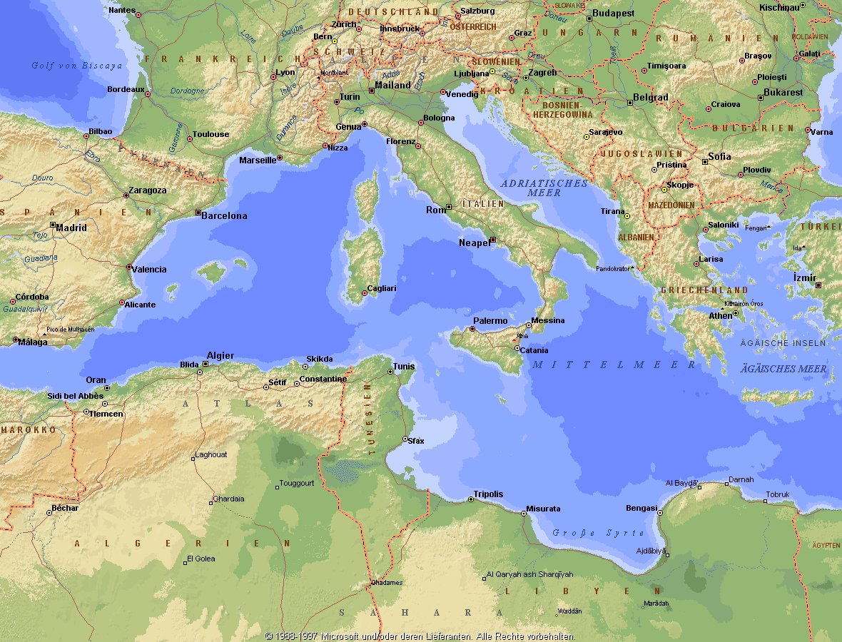
地中海,由北面的欧洲大陆,南面的非洲大陆以及东面的亚洲大陆包围着。东西长约4000千米,南北最宽处大约为1800千米,面积251.6万平方千米,是世界最大的陆间海。地中海的平均深度是1500米,最深处为5267米。
地中海西部通过直布罗陀海峡与大西洋相接,东部通过土耳其海峡(达达尼尔海峡和博斯普鲁斯海峡、马尔马拉海)和黑海相连。19世纪时开通了的苏伊士运河,接通了地中海与红海。 地中海是世界上最古老的海之一,[3] 而其附属的大西洋却是年轻的海洋。地中海处在欧亚板块和非洲板块交界处,是世界最强地震带之一。地中海地区有维苏威火山、埃特纳火山。
地中海作为陆间海,风浪较小,加之沿岸海岸线曲折、岛屿众多,拥有许多天然良好的港口,成为沟通三个大陆的交通要道。这样的条件,使地中海从古代开始海上贸易就很繁盛,促进了古代古埃及文明、古希腊文明、罗马帝国等的发展。现在也是世界海上交通的重要地区之一。其沿岸的腓尼基人、克里特人、希腊人,以及后来的葡萄牙人和西班牙人都是航海业发达的民族。著名的航海家如哥伦布、达·伽马、麦哲伦等,都出自地中海沿岸的国家。
地中海的沿岸夏季炎热干燥,冬季温暖湿润,被称作地中海性气候。植被,叶质坚硬,叶面有蜡质,根系深,有适应夏季干热气候的耐旱特征,属亚热带常绿硬叶林。这里光热充足,是欧洲主要的亚热带水果产区,盛产柑橘、无花果,和葡萄等,还有木本油料作物油橄榄。
Das Mittelmeer (lateinisch Mare Mediterraneum,[1] deshalb deutsch auch Mittelländisches Meer, präzisierend Europäisches Mittelmeer, im Römischen Reich Mare Nostrum) ist ein Mittelmeer zwischen Europa, Afrika und Asien, ein Nebenmeer des Atlantischen Ozeans und, da es mit der Straße von Gibraltar nur eine sehr schmale Verbindung zum Atlantik besitzt, auch ein Binnenmeer. Im Arabischen und Türkischen wird es auch als „Weißes Meer“ (البحر الأبيض/al-baḥr al-abyaḍ bzw. türk. Akdeniz) bezeichnet.
Zusammen mit den darin liegenden Inseln und den küstennahen Regionen Südeuropas, Vorderasiens und Nordafrikas bildet das Mittelmeer den Mittelmeerraum, der ein eigenes Klima (mediterranes Klima) hat und von einer eigenen Flora und Fauna geprägt ist.
地中海(ちちゅうかい、ラテン語: Mare Mediterraneum)は、北と東をユーラシア大陸、南をアフリカ大陸(両者で世界島)に囲まれた地中海盆地に位置する海である。面積は約3000平方キロメートル、平均水深は約1500メートル[2]。海洋学上の地中海の一つ。
地中海には、独立した呼称を持ついくつかの海域が含まれる(エーゲ海、アドリア海など)。地中海と接続する他の海としては、ジブラルタル海峡の西側に大西洋が、ダーダネルス海峡を経た北東にマルマラ海と黒海があり、南西はスエズ運河で紅海と結ばれている(「海域」「地理」で詳述)。
北岸の南ヨーロッパ、東岸の中近東、南岸の北アフリカは古代から往来が盛んで、「地中海世界」と総称されることもある[3]。
The Mediterranean Sea is a sea connected to the Atlantic Ocean, surrounded by the Mediterranean Basin and almost completely enclosed by land: on the north by Southern Europe and Anatolia, on the south by North Africa and on the east by the Levant. Although the sea is sometimes considered a part of the Atlantic Ocean, it is usually identified as a separate body of water. Geological evidence indicates that around 5.9 million years ago, the Mediterranean was cut off from the Atlantic and was partly or completely desiccated over a period of some 600,000 years, the Messinian salinity crisis, before being refilled by the Zanclean flood about 5.3 million years ago.
It covers an approximate area of 2.5 million km2 (965,000 sq mi), but its connection to the Atlantic (the Strait of Gibraltar) is only 14 km (8.7 mi) wide. The Strait of Gibraltar is a narrow strait that connects the Atlantic Ocean to the Mediterranean Sea and separates Gibraltar and Spain in Europe from Morocco in Africa. In oceanography, it is sometimes called the Eurafrican Mediterranean Sea or the European Mediterranean Sea to distinguish it from mediterranean seas elsewhere.[2][3]
The Mediterranean Sea has an average depth of 1,500 m (4,900 ft) and the deepest recorded point is 5,267 m (17,280 ft) in the Calypso Deep in the Ionian Sea. The sea is bordered on the north by Europe, the east by Asia, and in the south by Africa. It is located between latitudes 30° and 46° N and longitudes 6° W and 36° E. Its west-east length, from the Strait of Gibraltar to the Gulf of Iskenderun, on the southwestern coast of Turkey, is approximately 4,000 km (2,500 miles). The sea's average north-south length, from Croatia’s southern shore to Libya, is approximately 800 km (500 miles). The Mediterranean Sea, including the Sea of Marmara (connected by the Dardanelles to the Aegean Sea), has a surface area of approximately 2,510,000 square km (970,000 square miles).[4]
The sea was an important route for merchants and travellers of ancient times that allowed for trade and cultural exchange between emergent peoples of the region. The history of the Mediterranean region is crucial to understanding the origins and development of many modern societies.
The countries surrounding the Mediterranean in clockwise order are Spain, France, Monaco, Italy, Slovenia, Croatia, Bosnia and Herzegovina, Montenegro, Albania, Greece, Turkey, Syria, Lebanon, Israel, Egypt, Libya, Tunisia, Algeria, and Morocco; Malta and Cyprus are island countries in the sea. In addition, the Gaza Strip and the British Overseas Territories of Gibraltar and Akrotiri and Dhekelia have coastlines on the sea.
La mer Méditerranée (prononcé [me.di.tɛ.ʁa.ne]) est une mer intercontinentale presque entièrement fermée, bordée par les côtes d'Europe du sud, d’Afrique du Nord et d’Asie, depuis le détroit de Gibraltar à l'ouest aux entrées des Dardanelles et du canal de Suez à l'est. Elle s’étend sur une superficie d’environ 2,5 millions de kilomètres carrés. Son ouverture vers l’océan Atlantique par le détroit de Gibraltar est large de 14 kilomètres.
Elle doit son nom au fait qu’elle est littéralement une « mer au milieu des terres », en latin « mare medi terra »1.
Durant l’Antiquité, la Méditerranée était une importante voie de transports maritimes permettant l’échange commercial et culturel entre les peuples de la région — les cultures mésopotamiennes, égyptienne, perse, phénicienne, carthaginoise, berbère, grecque, arabe (conquête musulmane), ottomane, byzantine et romaine. L’histoire de la Méditerranée est importante dans l’origine et le développement de la civilisation occidentale.
Il mar Mediterraneo, detto brevemente Mediterraneo, è un mare intercontinentale situato tra Europa, Nordafrica e Asia occidentale connesso all'Oceano Atlantico. La sua superficie approssimativa è di 2,51 milioni di km² e ha uno sviluppo massimo lungo i paralleli di circa 3 700 km. La lunghezza totale delle sue coste è di 46 000 km, la profondità media si aggira sui 1 500 m, mentre quella massima è di 5 270 m presso le coste del Peloponneso. La salinità media si aggira dal 36,2 al 39 ‰.[2] La popolazione presente negli stati bagnati dalle sue acque ammonta a circa 450 milioni di persone.[2].
El mar Mediterráneo es uno de los mares del Atlántico. Está rodeado por la región mediterránea, comprendida entre Europa meridional, Asia Occidental y África septentrional. Fue testigo de la evolución de varias civilizaciones como los egipcios, los fenicios, hebreos, griegos, cartagineses, romanos, etc. Con aproximadamente 2,5 millones de km² y 3.860 km de longitud, es el segundo mar interior más grande del mundo, después del Caribe.1 Sus aguas, que bañan las tres penínsulas del sur de Europa (Ibérica, Itálica, Balcánica) y una de Asia (Anatolia), comunican con el océano Atlántico a través del estrecho de Gibraltar, con el mar Negro por los estrechos del Bósforo y de los Dardanelos y con el mar Rojo por el canal de Suez.2 Es el mar con las tasas más elevadas de hidrocarburos y contaminación del mundo.3
Средизе́мное мо́ре — межматериковое море, по происхождению представляющее собой глубоководную псевдоабиссальную внутришельфовую депрессию[1][2], связанную на западе с Атлантическим океаном Гибралтарским проливом[3].
В Средиземном море выделяют, как его составные части, моря: Адриатическое, Альборан, Балеарское, Ионическое, Кипрское, Критское, Левантийское, Ливийское, Лигурийское, Тирренское и Эгейское. В бассейн Средиземного моря также входят Мраморное, Чёрное и Азовское моря.
 *Mediterranean Sea
 Albania

 Eat and Drink
 Turkish cuisine

 Eat and Drink
 Spanish Kitchen

 Eat and Drink
 Greek cuisine

 Eat and Drink
 Portuguese cuisine
 Greece
 Israel
 Italy
Italy
 Croatia
 Libanon
 Malta
Malta
 Morocco
 Portugal
 Slovenia
 Spain
Spain
 Turkey
 Cyprus

Als Grundelemente der Landesküchen der Mittelmeerregion gelten: Olivenöl und Oliven frisches Gemüse wie Tomaten, Auberginen, Paprika, Zucchini Knoblauch, Lauch und Zwiebel Fisch und Meeresfrüchte Kräuter und Gewürze wie Thymian, Rosmarin, Koriander, Salbei, Fenchel, Kümmel, Anis, Oregano und Basilikum helles Brot, Nudeln und Reis in einigen Ländern regelmäßiger Rotweingenuss zum Essen.
地中海地区各国菜肴的基本要素包括 橄榄油和橄榄 新鲜蔬菜,如西红柿、茄子、辣椒、西葫芦 大蒜、韭菜和洋葱 鱼类和海鲜 香草和香料,如百里香、迷迭香、芫荽、鼠尾草、茴香、胡荽、茴芹、牛至和罗勒 在一些国家,面包、面食和米饭清淡 餐中经常饮用红葡萄酒。

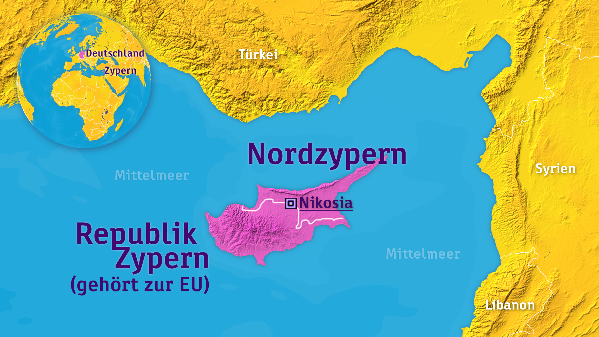
尼科西亚(希腊语:Λευκωσία、土耳其语:Lefkoşa),是塞浦路斯共和国及北塞浦路斯土耳其共和国的首都,也同时为塞浦路斯岛上最大的都市。首都被分为南部的希腊人及北部的土耳其人控制,是仅有的国家分裂之后南北政权皆定于此的首都,然而国际上承认尼科西亚为南塞浦路斯的首都。
尼科西亚位于塞浦路斯岛中部、临派迪亚斯河,北依横越岛国北岸的凯里尼亚山脉,西南临海拔约150米的特鲁多斯山。城市总面积50.5平方公里,人口近40万。
尼科西亚市也为中央政府所在地及全岛主要的商业中心,同时也是尼科西亚区的首府。此城市也被全球化与世界级城市研究小组与网络(GaWC)指定为B-级世界都市(Beta-)。
Nikosia (griechisch Λευκωσία Lefkosía, IPA: [lɛfkɔˈsi.a], türkisch Lefkoşa, altgriechisch Λήδρα Lēdra) ist eine geteilte Stadt im Zentrum der Mittelmeerinsel Zypern und Hauptort des gleichnamigen Bezirkes. Nikosia ist die Hauptstadt der Republik Zypern, der Nordteil zudem de-facto-Hauptstadt der international nicht anerkannten Türkischen Republik Nordzypern.
ニコシア(英: Nicosia)は、キプロス共和国の首都。北キプロス・トルコ共和国[1]の政庁所在地でもある。地元では、ギリシャ語でレフコシア(Lefkosia, ギリシア語: Λευκωσία [lefkoˈsi.a])、トルコ語でレフコシャ(トルコ語: Lefkoşa)と呼ばれている。
Nicosia (/ˌnɪkəˈsiːə/ NIK-ə-SEE-ə; Greek: Λευκωσία, translit. Lefkosia [lefkoˈsi.a]; Turkish: Lefkoşa [lefˈkoʃa]) is the largest city on the island of Cyprus. It is located near the centre of the Mesaoria plain, on the banks of the River Pedieos.
Nicosia is the capital and seat of government of Cyprus, and as such is the farthest southeast of all EU member states' capitals. It has been continuously inhabited for over 4,500 years and has been the capital of Cyprus since the 10th century. The Greek Cypriot and Turkish Cypriot communities of Nicosia segregated into the south and north of the city respectively in 1963, following the crisis from 1955–64 that broke out in the city. This division became a militarized border between the Republic of Cyprus and Northern Cyprus after Turkey invaded the island of Cyprus in 1974, occupying the north of the island, including northern Nicosia. Today North Nicosia is the capital of Northern Cyprus, a state recognized only by Turkey, that is considered to be occupied Cypriot territory by the international community.
Apart from its legislative and administrative functions, Nicosia has established itself as the island's financial capital and its main international business centre.[3] In 2018, Nicosia was the 32nd richest city in the world in relative purchasing power.[4]
Nicosie (en grec moderne : Λευκωσία, API: [lɛfkɔˈsi.a] / Lefkosía ; en turc : Lefkoşa, API: [lɛfkɔʃa]) est la capitale de la République de Chypre et de la République turque de Chypre du Nord, non reconnue internationalement. Ses plus de 300 000 habitants en font la ville la plus peuplée de l'île.
Depuis l’invasion turque de 1974, la ville est divisée de facto en deux. La partie septentrionale est séparée du reste de la ville par la « ligne verte », une zone démilitarisée contrôlée par l'Organisation des Nations unies (qui partage également la totalité de l'île entre ces deux États). À Nicosie, cette ligne est matérialisée par l'existence d'un mur, semblable au mur de Berlin, jalonné de plusieurs points de contrôle. Les Chypriotes grecs ont abattu une partie de ce mur le 8 mars 2007 : la rue Ledra est ainsi de nouveau ouverte à la circulation depuis le 3 avril 2008.
Nicosia (AFI: /nikoˈzia/[2][3]; in greco Λευκωσία, Lefkōsia; in turco Lefkoşa) è la capitale di Cipro. Il nome deriva dall'etimo francese Nicosie usata sotto il regno dei Lusignano. Nicosia è la città più popolosa di Cipro e il centro dell'economia cipriota.
Si tratta, a ottobre 2018, dell'unica capitale ancora divisa: una recinzione militare di separazione, detta "linea verde", che corre da nordovest a sudest, la divide infatti in due zone delle quali quella meridionale capitale della Repubblica di Cipro e quella settentrionale della Repubblica turca di Cipro, riconosciuta solo dalla Turchia.
Nicosia (en griego, Λευκωσία, Lefkosia; en turco, Lefkoşa) es la ciudad más grande de la isla de Chipre. Situada sobre el río Pedieos, y al igual que la isla, la ciudad de Nicosia también está dividida: la parte sur es la capital de la República de Chipre, y la parte norte es la capital de la República Turca del Norte de Chipre. En los tiempos antiguos, la ciudad fue conocida como Ledra, y era uno de los doce reinos antiguos de la isla de Chipre. Nicosia ha sido la capital de la isla por más de mil años, y fue conquistada por los francos, los venecianos, los turcos y el Imperio británico.
El centro histórico de Nicosia está encerrado dentro de un gran muro medieval construido por los venecianos. Ese muro es hoy el monumento más conocido de la ciudad. Las puertas y los bastiones de ese muro hoy acomodan edificios importantes, como el Ayuntamiento. La parte norte de la ciudad está ocupada por el gobierno turco chipriota, y funciona como capital de la República Turca del Norte de Chipre, un Estado solo reconocido por Turquía. Nicosia es hoy la única capital dividida del mundo.1
La ciudad se desarrolla con un ritmo rápido y tiene un nivel de vida de los más altos en el mundo. Además, es la sede de la Universidad de Chipre y de otras tres universidades privadas.
 *Mediterranean Sea
 Commonwealth of Nations

 Geography

 Geography
 ***IMF Developed countries
 IMF Developed countries
 IMF Developed countries
 TOP6
TOP6

 States of Asia

 States of Europe
 Cyprus
 *Mediterranean Sea
 Egypt
Egypt
 Algeria
 Belgium
 Bulgaria
 Germany
 France

 History
 H 1000 - 500 BC

 History
 J 0 - 500 AD

 History
 I 500 - 0 BC
 Israel
 Italy
Italy
 Jordan
 Croatia
 Libanon
 Libya
Libya
 Morocco
 Netherlands
 Portugal

 Review
 Romania
 Switzerland
 Serbia
 Spain
Spain
 Syria
Syria

 Traditions
 Tunisia
 Turkey
 Hungary
 United Kingdom

 Civilization
 Cyprus

Als römische Architektur bezeichnet man die Baukunst der Römer zur Zeit der römischen Republik und der Kaiserzeit. Die römische Architekturgeschichte umfasst damit einen Zeitraum von etwa neun Jahrhunderten (500 v. Chr.–400 n. Chr.). Die Epochen der römischen Architektur werden nach einzelnen Herrschern, Dynastien oder retrospektiv formulierten historischen Zeitabschnitten benannt. Die seitens der Klassischen Archäologie geprägten Epochen- oder Stilbegriffe finden keine Entsprechungen in der schriftlichen antiken Überlieferung, entsprechen also nicht antiker Wahrnehmung und Einteilung.
古罗马建筑(英语:Ancient Roman architecture),是指由古罗马人创造并且扩展到地中海沿岸其所控制疆域的一种新风格的建筑艺术,经常简称为罗马建筑(英语:Roman architecture)。它直接继承了古希腊晚期的建筑成就,而且将其向前大大推进,使之在1到3世纪达到奴隶制时代全世界建筑的顶峰[1][2]。在西方学术界传统上特指古罗马共和国与帝国时期的建筑[3],中文学术界定义较为宽泛,有时可以包括前期的伊特鲁里亚建筑[4],也可以包括分裂之后的西罗马帝国建筑[2],但是一般不包含东罗马帝国建筑。
 Andorra
 Belgium
 Bulgaria
 Denmark
 Germany
 Estonia
 Finland
 France
 Gibraltar
 Greece

 Hand in Hand
 Ireland
 Iceland
 Italy
Italy
 Croatia
 Latvia
 Liechtenstein
 Lithuania
 Luxembourg
 Malta
Malta
 Monaco
 Netherlands
 Northern Ireland
 Norwegen
 Austria
 Poland
 Portugal
 Romania
 San Marino
 Sweden
 Switzerland
 Slovakia
 Slovenia
 Spain
Spain
 Czech Republic
 Hungary

 Vacation and Travel
 Vatican city
 United Kingdom
 Cyprus

《申根协议》(德语:Schengener Abkommen;法语:Convention de Schengen;荷兰语:Verdrag van Schengen),是一项欧洲大陆国家间的条约协定,其签约目的是取消相互之间的边境检查点,并协调对申根区之外的边境控制。即在成员国相互之间取消边境管制,持有任一成员国有效身份证或申根签证的人可以在所有成员国境内自由流动。根据该协定,旅游者如果持有其中一国的旅游签证即可合法地到所有其他申根国家。
《申根协议》的成员国亦称“申根国家”或者“申根协议国”,成员国的整体又称“申根区”。申根区目前包含26个国家,其中有22个属于欧盟成员。四个非欧盟成员国中,冰岛和挪威以北欧护照联盟成员国的身份加入申根区,官方分类属于与欧盟申根区活动相关的国家。不属于欧洲大陆的爱尔兰没有加入。
Die Schengener Abkommen sind internationale Übereinkommen, insbesondere zur Abschaffung der stationären Grenzkontrollen an den Binnengrenzen der teilnehmenden Staaten. Dies sind im Kern die Mitglieder der Europäischen Union, jedoch ohne Irland, Rumänien, Bulgarien und Zypern. Durch Zusatzabkommen mit der Europäischen Union wurde der Anwendungsbereich auf Island, Liechtenstein, Norwegen und die Schweiz ausgedehnt. Der Gültigkeitsbereich des Abkommens wird gemeinhin als Schengen-Raum bezeichnet.
Das erste dieser Abkommen vom 14. Juni 1985 sollte vor allem die Schaffung eines europäischen Binnenmarktes vorantreiben und wurde nach dem Unterzeichnungsort benannt, der Gemeinde Schengen im Großherzogtum Luxemburg. Die mehrfach modifizierten Regelungen (Schengen I bis III) konstituieren den Schengen-Besitzstand, einen wesentlichen Pfeiler des „Raumes der Freiheit, der Sicherheit und des Rechts“[1] der Europäischen Union. Bedeutung und Verdienste des Schengener Abkommens werden im Europäischen Museum Schengen dokumentiert.
Das unkontrollierte Passieren der Binnengrenzen als Prinzip der Schengener Abkommen wurde im Zuge der Flüchtlingskrise in Europa ab 2015 zeitweise von mehreren europäischen Ländern außer Kraft gesetzt, nachdem einzelne Mitgliedstaaten die Sicherung der Außengrenzen der Europäischen Union gefährdet sahen.
Von März bis Juni 2020 waren wegen der COVID-19-Pandemie zahlreiche Grenzen zwischen Mitgliedstaaten geschlossen.[2][3] Im Februar 2021 kam es wegen der Pandemie erneut zu Grenzschließungen.
 Egypt
Egypt
 Australia
 Belgium
 Brunei Darussalam
 China
China
 Germany
 Djibouti
 France
 Greece
 Guangdong Sheng-GD
 Hongkong Tebiexingzhengqu-HK
 India
India
 Indonesia


 IT-Times
 Late Classical, Romantic (Early, Middle, Late)
 Italy
Italy
 Japan
Japan
 Malaysia
 Morocco
 Myanmar
 Oman
Oman
 Pakistan
 Philippines
 Portugal
 Republic of Korea
 Saudi Arabia
 Shanghai Shi-SH
 Singapore
 Sri Lanka
 Taiwan Sheng-TW
 Thailand
 Turkey
 United Arab Emirates
 United Kingdom
 Vietnam
 Cyprus
 International cities
 Architecture
 World Heritage
 European Union