
Deutsch-Chinesische Enzyklopädie, 德汉百科
 Silk road

Während der Tang-Dynastie galt Lianyungang als Ausgangspunkt einer Handelslinie, die China mit anderen Ländern in Südostasien verband.
江蘇省の東北部にあって黄海に面し、北は山東省日照市、西は徐州市、淮安市、南は淮安市、塩城市に隣接。気候は海流の影響で温暖で、年平均気温は14℃、年間降水量は930mm。全体に海沿いの平坦な土地だが、西部には山地があり、その最高点である南雲台山の玉女峰(標高625m)は江蘇省の最高点でもある。 農業も盛んで、水稲や小麦、綿、大豆、落花生などが生産されている。
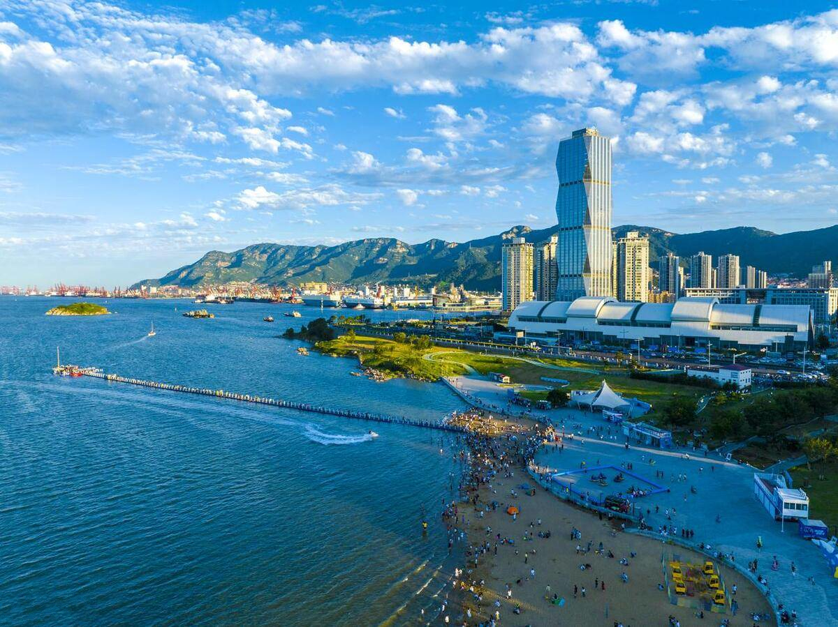
連雲港市(れんうんこう-し)は中華人民共和国江蘇省に位置する地級市。全国十大港湾の一つである貿易港を有し、中国に14ある沿海の経済技術開発区の一つでもある。連雲港の古い名は海州であり、春秋時代には呉を滅ぼした越王勾践がこの地を首都とし中原の覇者となった。秦朝以降は江蘇地方の重要港湾都市とされ、清末には税関が設置されている。改革開放政策が発表されてからは中国で最初に指定された14箇所の経済技術開発区の一つになった。
行政区画としては1935年(民国24年)に灌雲県連雲港地区に新設された連雲市を前身とする。1948年(民国37年)には東海県海州、新浦地区を統合し新海連特区と改編された。中華人民共和国が成立すると1949年に新海連市と改称し山東省の管轄とした。その後1952年に江蘇省に移管、1961年に連雲港市と改称され現在に至る。
Lianyungang (simplified Chinese: 连云港; traditional Chinese: 連雲港; pinyin: Liányúngǎng) is a prefecture-level city in northeastern Jiangsu province, China. It borders Yancheng to its southeast, Huai'an and Suqian to its south, Xuzhou to its southwest, and the province of Shandong to its north. Its name derives from Lian Island, the largest island in Jiangsu which lies off its coastline, and Yuntai Mountain, the highest peak in Jiangsu, a few miles from the town center, and the fact that it is a port. The name can be literally translated as the Port Connecting the Clouds.
Lianyungang (连云港 ; pinyin : Liányúngǎng) est une ville du nord-est de la province du Jiangsu en Chine.
Lianyungang (in cinese: 连云港; in pinyin: Liányúngǎng; letteralmente "il porto collegato alle nuvole") è una città della Cina nella provincia dello Jiangsu.
Lianyungang, léase: Lianyún-ka-áng (en chino 连云港市,pinyin: Liányúngǎngshí,literalmente,el puerto conectado a las nubes). Es una ciudad-prefectura en la provincia de Jiangsu, República Popular de China. Limita al norte con Shandong,al sur con Suqian,al oeste con Xuzhou y al este con el Mar de China Oriental. Su nombre deriva de la isla Lian (Isla Dongxilian) la isla más grande de la provincia de Jiangsu que se encuentra frente a sus costas, y de la montaña Yuntai, el pico más alto de la provincia de Jiangsu, a pocos kilómetros del centro de la ciudad.
Lianyungang fue uno de los cuatro puertos originales abiertos para el comercio exterior en la década de 1680 por el Gobierno de la Dinastía Qing. Los otros eran Ningbo, Xiamen y Guangzhou.
Ляньюньга́н (кит. упр. 连云港, пиньинь Liányúngǎng , переводится как «порт (ган) у острова Дунсилянь и горы Юньтай») — городской округ в провинции Цзянсу КНР.
Eurovision Song Contest,ESC
 History
 International cities
 *European Capital of Culture
Portugal
Silk road
*European Capital of Culture
Portugal
Silk road
 Sport
The Ocean Race
Umwelthauptstadt Europas
Sport
The Ocean Race
Umwelthauptstadt Europas
 World Heritage
 Important port
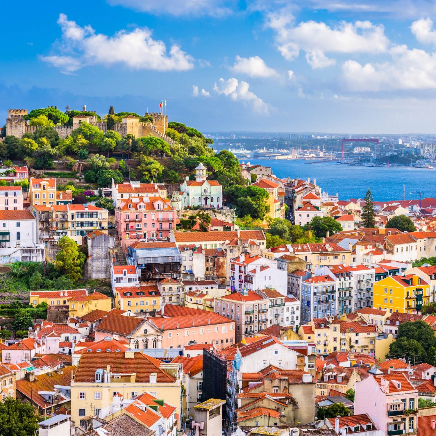
里斯本(葡萄牙语:Lisboa),亦称为葡京,是葡萄牙共和国的首都和最大都市。其位置位于葡萄牙中南部大西洋沿岸,城北为辛特拉山,城南为特茹河出海口,与伦敦、巴黎、罗马等同为西欧历史最悠久的城市。市区面积84.6平方公里、人口547,631人(2011年)。包含卫星城的都会区人口超过300万,相当于葡萄牙人口的27%左右。公元前205年起为罗马人统治,当时的统治者凯撒把这个地区升格为市,并命名为拉丁语:Felicitas Julia(意为“祝贺凯撒”)。1256年起正式成为葡萄牙王国的首都,从此发展成为欧洲和地中海一带重要的港口与贸易城市。地理大发现时代很多航海家都是由里斯本出发到世界不同的地方探险的,此后成为葡萄牙殖民帝国富甲一方的政治与商业中心,现今与波尔图同为葡萄牙两大代表性城市。
Lissabon (portugiesisch Lisboa [liʒˈβoɐ]) ist die Hauptstadt und die größte Stadt Portugals sowie des gleichnamigen Regierungsbezirks und liegt an einer Bucht der Flussmündung des Tejo im äußersten Südwesten Europas an der Atlantikküste der Iberischen Halbinsel.
Der Handelshafen an der Tejo-Bucht wurde vor der römischen Herrschaft Alis Ubbo genannt. Lissabon, eine Gründung der Phönizier, erhielt zu Zeiten Julius Caesars unter dem Namen Colonia Felicitas Iulia römisches Stadtrecht. 711 fiel der Ort wie der größte Teil der Iberischen Halbinsel an die Mauren; im Kontext des Zweiten Kreuzzugs wurde Lissabon 1147 portugiesisch und damit wieder unter christliche Herrschaft gestellt. Nach der Verlegung des Königssitzes von Coimbra wurde die Stadt im Jahr 1256 unter König Afonso III. zur Hauptstadt des Königreichs Portugal. Um 1500 erlebte Lissabon einen brillanten Aufstieg zu einer der glanzvollsten Handels- und Hafenstädte der damaligen Zeit.
Ein gewaltiges Erdbeben besiegelte im Jahr 1755 den wirtschaftlichen Niedergang der Stadt, der bereits Jahrzehnte zuvor schleichend eingesetzt hatte, und sorgte in ganz Europa für Aufsehen. Im 19. Jahrhundert erlebte Lissabon einen Wiederaufstieg.
In den letzten Jahren ist die Stadt allerdings massiv geschrumpft (von über 800.000 Einwohnern um 1980 auf etwa 500.000[3] um 2017); viele Menschen sind in das Umland gezogen. Lissabon hat mit erheblichen strukturellen Problemen zu kämpfen, unter denen vor allem die marode Bausubstanz vieler Gebäude und der enorme Straßenverkehr herausragen.
Als noch immer größte Stadt Portugals mit dem wichtigsten Hafen, dem Regierungssitz, den obersten Staats- und Regierungsbehörden, mehreren Universitäten und der Akademie der Wissenschaften ist Lissabon heute das politische, wirtschaftliche und kulturelle Zentrum des Landes.
Lissabon ist Sitz einiger Agenturen der Europäischen Union, darunter der Europäischen Beobachtungsstelle für Drogen und Drogensucht und der Europäischen Agentur für die Sicherheit des Seeverkehrs. Auch die Gemeinschaft der Portugiesischsprachigen Länder (CPLP) hat ihren Hauptsitz in Lissabon.
リスボン(ポルトガル語: Lisboa IPA: [ɫiʒˈboɐ] (![]() 音声ファイル)[1]、[liʒˈβoɐ] リジュボア[2]、英語: Lisbon IPA: [ˈlɪzbən])は、ポルトガルの首都で同国最大の都市である。市域人口は547,631人を擁し[3]、市域面積は84.8 km2 (33 sq mi)に過ぎないが、そのぶん高い人口密度を保持している。リスボンの都市的地域は行政区としての市域を越えて広がっており、人口は300万人を超え[4]、面積は958 km2 (370 sq mi)[4]を占めており、欧州連合域内では11番目に大きな都市圏 (en) を形成している。約3,035,000人[5][6] の人々が、リスボン都市圏に暮らし、ポルトガルの全人口の約27%を占めている。リスボンはヨーロッパの大都市では最も西にある都市であると同時に、ヨーロッパの中で最も西側に位置する政府首都でもある。ヨーロッパ諸国の首都のなかで唯一の大西洋岸にあるリスボンは、イベリア半島の西側、テージョ川の河畔に位置している。
音声ファイル)[1]、[liʒˈβoɐ] リジュボア[2]、英語: Lisbon IPA: [ˈlɪzbən])は、ポルトガルの首都で同国最大の都市である。市域人口は547,631人を擁し[3]、市域面積は84.8 km2 (33 sq mi)に過ぎないが、そのぶん高い人口密度を保持している。リスボンの都市的地域は行政区としての市域を越えて広がっており、人口は300万人を超え[4]、面積は958 km2 (370 sq mi)[4]を占めており、欧州連合域内では11番目に大きな都市圏 (en) を形成している。約3,035,000人[5][6] の人々が、リスボン都市圏に暮らし、ポルトガルの全人口の約27%を占めている。リスボンはヨーロッパの大都市では最も西にある都市であると同時に、ヨーロッパの中で最も西側に位置する政府首都でもある。ヨーロッパ諸国の首都のなかで唯一の大西洋岸にあるリスボンは、イベリア半島の西側、テージョ川の河畔に位置している。
リスボンは金融や商業、出版、娯楽、芸術、貿易、教育、観光と言った様々な分野で重要な都市であることから、世界都市と見なされている。[7][8] ポルテラ空港は2012年に1,530万人の旅客を扱い、高速道路Auto-estradaや高速列車アルファ・ペンドゥラールによりポルトガルの他の主要都市と結ばれている。[9]南ヨーロッパではイスタンブール、ローマ、バルセロナ、マドリード、アテネ、ミラノに次いで7番目に多くの観光客が訪れる都市で、2009年には1,740,000人の観光客が訪れた。[10]リスボンの総所得は世界の都市で32番目に高い位置を占めている。[11] ポルトガルの多国籍企業の本社はほとんどがリスボン地域に置いており、世界では9番目に多くの国際会議が開かれる都市でもある。[12]
また、ポルトガルの政治の中心でポルトガル政府の首府やポルトガルの大統領官邸が置かれている他、リスボン地域やリスボン県の中心でもある。
世界的にも古い歴史がある都市の一つで、西ヨーロッパでは最古の都市であり現代のヨーロッパの他の首都であるロンドンやパリ、ローマなどよりも数百年遡る。ガイウス・ユリウス・カエサルはフェリキタス・ユリアFelicitas Juliaと呼ばれるムニキピウムを創建し、オリピソOlissipoの名に加えた。5世紀から一連のゲルマン人部族により支配され、8世紀にはムーア人により攻略された。1147年、ポルトガル王国の建国者アフォンソ1世下のレコンキスタでのリスボン攻防戦で、ポルトガルはムーア人からリスボンを奪回する。以来、リスボンはポルトガルの主要な政治、経済、文化の中心となっている。ほとんどの首都と異なり、リスボンのポルトガルの首都としての地位は法令や書面の形式では公式に認められたり確認されていない。首都としての地位は憲法制定会議を通じて事実上の首都としてポルトガルの憲法に定められている。
リスボンには欧州薬物・薬物依存監視センター(EMCDDA)と欧州海上保安機関(EMSA)の2つの欧州連合の専門機関が置かれている。「ルゾフォニアの世界の首都」と呼ばれポルトガル語諸国共同体の本部がペナフィエル伯宮殿に置かれている。ベレンの塔とジェロニモス修道院の2つはUNESCOの世界遺産に登録されている。さらに1994年、リスボンは欧州文化首都になり、1998年にはリスボン国際博覧会が開催された。
Lisbon (/ˈlɪzbən/; Portuguese: Lisboa, IPA: [liʒˈboɐ] (![]() listen))[2] is the capital and the largest city of Portugal, with an estimated population of 505,526[1] within its administrative limits in an area of 100.05 km2.[3] Its urban area extends beyond the city's administrative limits with a population of around 2.8 million people, being the 11th-most populous urban area in the European Union.[4] About 3 million people live in the Lisbon Metropolitan Area (which represents approximately 27% of the country's population).[5] It is mainland Europe's westernmost capital city and the only one along the Atlantic coast. Lisbon lies in the western Iberian Peninsula on the Atlantic Ocean and the River Tagus. The westernmost areas of its metro area form the westernmost point of Continental Europe, which is known as Cabo da Roca, located in the Sintra Mountains
listen))[2] is the capital and the largest city of Portugal, with an estimated population of 505,526[1] within its administrative limits in an area of 100.05 km2.[3] Its urban area extends beyond the city's administrative limits with a population of around 2.8 million people, being the 11th-most populous urban area in the European Union.[4] About 3 million people live in the Lisbon Metropolitan Area (which represents approximately 27% of the country's population).[5] It is mainland Europe's westernmost capital city and the only one along the Atlantic coast. Lisbon lies in the western Iberian Peninsula on the Atlantic Ocean and the River Tagus. The westernmost areas of its metro area form the westernmost point of Continental Europe, which is known as Cabo da Roca, located in the Sintra Mountains
Lisbon is recognised as an alpha-level global city by the Globalization and World Cities (GaWC) Study Group because of its importance in finance, commerce, media, entertainment, arts, international trade, education and tourism.[6] Lisbon is the only Portuguese city besides Porto to be recognised as a global city.[7][8] It is one of the major economic centres on the continent, with a growing financial sector and one of the largest container ports on Europe's Atlantic coast.[9] Additionally, Humberto Delgado Airport served 26.7 million passengers in 2017, being the busiest airport in Portugal, the 3rd busiest in the Iberian Peninsula and the 20th busiest in Europe,[10] and the motorway network and the high-speed rail system of Alfa Pendular links the main cities of Portugal (such as Braga, Porto and Coimbra) to Lisbon.[11] The city is the 9th-most-visited city in Southern Europe, after Rome, Istanbul, Barcelona, Milan, Venice, Madrid, Florence and Athens, with 3,320,300 tourists in 2017.[12] The Lisbon region contributes with a higher GDP PPP per capita than any other region in Portugal. Its GDP amounts to 96.3 billion USD and thus $32,434 per capita.[13][14] The city occupies the 40th place of highest gross earnings in the world.[15] Most of the headquarters of multinationals in the country are located in the Lisbon area.[16] It is also the political centre of the country, as its seat of Government and residence of the Head of State.
Lisbon is one of the oldest cities in the world, and one of the oldest in Western Europe, predating other modern European capitals such as London, Paris and Rome by centuries. Julius Caesar made it a municipium called Felicitas Julia, adding to the name Olissipo. Ruled by a series of Germanic tribes from the 5th century, it was captured by the Moors in the 8th century. In 1147, the Crusaders under Afonso Henriques reconquered the city and since then it has been a major political, economic and cultural centre of Portugal. Unlike most capital cities, Lisbon's status as the capital of Portugal has never been granted or confirmed officially – by statute or in written form. Its position as the capital has formed through constitutional convention, making its position as de facto capital a part of the Constitution of Portugal.
Lisbonne [liz.bɔn]2 (en portugais : Lisboa [liʒˈboɐ]3 Écouter) est la capitale et la plus grande ville du Portugal. Considérée comme une « ville mondiale » selon le classement 2010 du Réseau d’étude sur la mondialisation et les villes mondiales (GaWC)4 comme Taipei, Miami, Varsovie ou Munich, Lisbonne est également le chef-lieu du district de Lisbonne, du Grand Lisbonne et de la zone métropolitaine de Lisbonne. Ses habitants sont habituellement appelés Lisboètes (du portugais lisboeta), mais on rencontre aussi les termes Lisbonnin et Lisbonnais.
D'après le recensement de 2011, la municipalité compterait une population de 545 733 habitants5, répartie sur une surface de 83,7 km2. L'agglomération de Lisbonne (Grand Lisbonne) compte une population légèrement supérieure à 2,042 millions d'habitants (NUTS III), ce qui en fait la 15e agglomération européenne en importance. Son aire urbaine (Région de Lisbonne) compte quant à elle 2 821 876 habitants (NUTS II), représentant 26,7 % de la population portugaise. C'est la ville la plus riche du Portugal, avec un PIB par habitant supérieur au PIB moyen de l'Union européenne.
Située à l'embouchure du Tage, la municipalité est divisée en 24 freguesias (paroisses civiles ou arrondissements). Elle est limitée par les communes de Odivelas et Loures au nord, Oeiras à l'ouest, Amadora au nord-ouest et l'estuaire du Tage (la mer de Paille) au sud-est, au travers duquel, la ville est au contact des municipalités de la rive sud : Almada, Seixal, Barreiro, Moita, Montijo et Alcochete.
Deux agences européennes ont leur siège à Lisbonne : l'Observatoire européen des drogues et des toxicomanies et l'Agence européenne pour la sécurité maritime, toutes les deux avec des projets de nouveaux sièges près du fleuve. L'organisation de la Communauté des pays de langue portugaise a également ses bureaux dans la capitale portugaise.
Lisbona (/liz'bona/; in portoghese: Lisboa, /liʒ'boɐ/) è la capitale e principale città del Portogallo, con una popolazione di circa 506 892 abitanti all'interno dei suoi confini amministrativi, mentre circa 2,8 milioni sono gli abitanti della sua area urbana (undicesima nell'Unione Europea). È la capitale europea più occidentale (isole escluse) e l'unica ad affacciarsi sull'Oceano Atlantico. La città è situata nella parte occidentale della Penisola iberica, presso l'estuario del fiume Tago, ed inoltre la parte più occidentale della sua area urbana è la zona geografica più occidentale dell'intera Europa continentale.
Lisbona è considerata una città globale in virtù della sua discreta importanza in settori come finanza, commercio, editoria, arte, commercio internazionale, istruzione e turismo. È un importante centro economico, con un settore finanziario in crescita ed uno tra i più importanti porti affaccianti sull'Atlantico. L'aeroporto di Lisbona serve circa 20 milioni di passeggeri all'anno e importanti strade e autostrade collegano la capitale alle altre città portoghesi. La città è la settima più visitata nel Sud Europa, dopo Istanbul, Roma, Barcellona, Madrid, Atene e Milano, con 1 740 000 turisti nel 2009. La regione di Lisbona ha un PIL procapite considerevolmente più alto della media nazionale, classificandosi al decimo posto nella UE con 110 miliardi di euro e 39.375€ pro capite, dato del 40% più alto rispetto alla media dell'unione. La maggior parte dei quartier generali delle multinazionali portoghesi è localizzata in città, che è anche il maggior centro politico dello stato, essendo sede del Governo e della Presidenza della Repubblica.
Lisboa (pronunciación en portugués: ![]() [liʒˈβoɐ] (?·i)) es la capital1 y mayor ciudad de Portugal. Situada en la desembocadura del río Tajo (Tejo), es la capital del país, capital del distrito de Lisboa, de la región de Lisboa, del Área Metropolitana de Lisboa, y es también el principal centro de la subregión de la Gran Lisboa. La ciudad tiene una población de 547 773 habitantes y su área metropolitana se sitúa en los 2 810 923 en una superficie de 2921,90 km². Esta área contiene el 20 % de la población del país. Lisboa es la ciudad más rica de Portugal[cita requerida].
[liʒˈβoɐ] (?·i)) es la capital1 y mayor ciudad de Portugal. Situada en la desembocadura del río Tajo (Tejo), es la capital del país, capital del distrito de Lisboa, de la región de Lisboa, del Área Metropolitana de Lisboa, y es también el principal centro de la subregión de la Gran Lisboa. La ciudad tiene una población de 547 773 habitantes y su área metropolitana se sitúa en los 2 810 923 en una superficie de 2921,90 km². Esta área contiene el 20 % de la población del país. Lisboa es la ciudad más rica de Portugal[cita requerida].
El municipio de Lisboa, que coincide con la ciudad propiamente dicha (excluyendo la aglomeración urbana continua, más grande, que la rodea), tiene una extensión de 100,05 km², en los que en 2011 vivían 547 733 habitantes.2 Su densidad demográfica es de 5 474,59 hab/km². El municipio se subdivide en 24 freguesias (parroquias) y limita al norte con los municipios de Odivelas y Loures, al oeste con Oeiras, al noroeste con Amadora y al sureste con el estuario del Tajo. A través del estuario, Lisboa se une a los municipios de la Margen Sur: Almada, Seixal, Barreiro, Moita, Montijo y Alcochete.
Лиссабо́н[4], Лисабо́н[5][6] (порт. Lisboa, МФА (порт.): [liʒˈβoɐ]) — столица, крупнейший город и главный порт Португалии.
Лиссабон является одним из старейших городов мира и старейшим городом Западной Европы, на века превосходя в возрасте такие современные европейские столицы, как Лондон, Париж.
В Лиссабоне средиземноморский климат. В нём самые теплые зимы среди всех европейских метрополий — средние температуры с декабря по февраль составляют 18 °C днем и 11 °C ночью. Типичный летний сезон длится около шести месяцев — с мая по октябрь, хотя и в апреле температура порой достигает 25-32 °C.
England
International cities
*European Capital of Culture
Silk road
United Kingdom
World Heritage
Important port

利物浦(英语:Liverpool /ˈlɪvərpuːl/),是英格兰西北部著名港口城市,是默西赛德都市郡的5个自治市之一,由利物浦市议会治理。1207年时以自治市镇的身份成立,1880年获得城市地位。2011年人口约为466,415[4],是利物浦都会区的中心[5]。利物浦市区的人口约为2,200,000,英国第四大城市。[6]
利物浦居民称为Liverpudlians,但也称“Scousers”,后裔名称来自当地名吃炖汤“scouse”,同时这一词还指利物浦方言[7]。利物浦居民种族颇为丰富,有全英最古老的黑人社区和全欧最古老的华人社区。
吉尼斯世界纪录将利物浦评为“世界流行乐之都”[8],披头士、比利·弗里、格里和带头人及其他许多乐队都是在此发迹的。两支英超联球会:利物浦和埃弗顿也位于利物浦。2007年时利物浦庆祝其800岁诞辰,次年与斯塔万格一起成为欧洲文化之都[9]。
利物浦的历史建筑保护良好,其中许多都举世闻名。市中心的多个地区在2004年被联合国教科文组织评为世界遗产,并称利物浦海事商城。[10]
Liverpool [ˈlɪvəpuːl] ist eine Stadt und Metropolitan Borough im Nordwesten von England im Vereinigten Königreich Großbritannien und Nordirland, an der Mündung des Flusses Mersey. Im Jahr 2014 hatte die Stadt 473.073 Einwohner, im Ballungsraum Liverpool Urban Area lebten 817.000 Einwohner. Liverpool ist der zweitgrößte Exporthafen Großbritanniens.
Der historische Teil der Hafenstadt wurde 2004 zum Weltkulturerbe erklärt. Bekannt ist die Stadt durch die traditionsreichen Fußballvereine FC Everton und FC Liverpool sowie durch ihre pulsierende Musikszene, aus der in den 1960er Jahren unter anderem die Rockband The Beatles hervorging. 2008 war Liverpool (neben Stavanger in Norwegen) Europäische Kulturhauptstadt.
Die Einwohner Liverpools werden offiziell Liverpudlians genannt. Besser bekannt ist die Bezeichnung Scousers, nach dem in Liverpool gesprochenen Dialekt Scouse, dessen Name sich wiederum von der lokalen Eintopfspezialität Scouse herleitet.
リヴァプール(Liverpool)は、イギリス・イングランド北西部マージーサイド州の中心都市である。面積は111.84平方キロメートル、2015年の人口は47万8580人[1]。かつてはイギリスの主要な港湾都市であったが、世界的ロック・バンドであるザ・ビートルズの出身地であることから、いまでは観光都市として知られる。2008年の欧州文化首都の一つ。
Liverpool (/ˈlɪvərpuːl/) is a city in North West England, with an estimated population of 491,500 in 2017.[5] Its metropolitan area is the fifth-largest in the UK, with a population of 2.24 million in 2011.[6] The local authority is Liverpool City Council, the most populous local government district in the metropolitan county of Merseyside and the largest in the Liverpool City Region.
Liverpool is on the eastern side of the Mersey Estuary, and historically lay within the ancient hundred of West Derby in the south west of the county of Lancashire.[7][8] It became a borough in 1207 and a city in 1880. In 1889, it became a county borough independent of Lancashire. Its growth as a major port was paralleled by the expansion of the city throughout the Industrial Revolution. Along with handling general cargo, freight, raw materials such as coal and cotton, the city merchants were involved in the Atlantic slave trade. In the 19th century, it was a major port of departure for Irish and English emigrants to North America. Liverpool was home to both the Cunard and White Star Line, and was the port of registry of the ocean liner RMS Titanic, the RMS Lusitania, RMS Queen Mary and RMS Olympic.
The popularity of the Beatles and other groups from the Merseybeat era contributes to Liverpool's status as a tourist destination. Liverpool is also the home of two Premier League football clubs, Liverpool and Everton, matches between the two being known as the Merseyside derby. The Grand National horse race takes place annually at Aintree Racecourse on the outskirts of the city.
The city celebrated its 800th anniversary in 2007. In 2008, it was nominated as the annual European Capital of Culture together with Stavanger, Norway.[9] Several areas of the city centre were granted World Heritage Site status by UNESCO in 2004. The Liverpool Maritime Mercantile City includes the Pier Head, Albert Dock, and William Brown Street.[10] Liverpool's status as a port city has attracted a diverse population, which, historically, was drawn from a wide range of peoples, cultures, and religions, particularly from Ireland and Wales. The city is also home to the oldest Black African community in the country and the oldest Chinese community in Europe.
Natives and residents of the city of Liverpool are referred to as Liverpudlians, and colloquially as "Scousers", a reference to "scouse", a form of stew. The word "Scouse" has also become synonymous with the Liverpool accent and dialect.
Liverpool est une cité et un district métropolitain du Merseyside dans la région de l'Angleterre du Nord-Ouest sur la rive est et nord de l'estuaire du fleuve Mersey. La ville faisait partie du comté du Lancashire jusqu'en 1974 avant la formation du comté de Merseyside.
La ville est fondée en 1207 et obtient le statut de cité en 1880. Avec une population de 491 500 habitants en 2017, c'est la sixième plus grande ville du Royaume-Uni, et la quatrième d'Angleterre ; l'aire urbaine de Liverpool comprend 864 122 habitants en 2011 (6e région urbaine du Royaume-Uni)1. Ses habitants s'appellent les Liverpuldiens (Liverpudlians en anglais)2.
L'ensablement progressif de l'estuaire de la Dee, sur lequel se tenait le port de Chester depuis l'époque romaine, a permis à Liverpool de devenir un port majeur. Au début du XIXe siècle, alors que l'Empire britannique était en pleine expansion économique, environ 40 % de son commerce passe par Liverpool, ce qui contribue grandement à l'importance de la ville. En 1930, la ville est à son apogée avec une population de plus de 850 000 habitants.
Bombardée durant la Seconde Guerre mondiale, la ville entame au lendemain de la guerre sa reconstruction, mais elle est rapidement touchée par la crise industrielle des années 1970 qui affecte son activité portuaire et dont elle se remet lentement. Liverpool a ainsi perdu de nombreux habitants mais demeure encore une métropole économique de premier rang pour le Nord-Ouest anglais. La ville a entamé un processus de reconversion dans le secteur tertiaire : services à l'industrie, activités commerciales (Liverpool One), et le tourisme (Albert Dock).
Liverpool est associée à la popularité des Beatles, un des plus grands phénomènes de l'industrie discographique mondiale, et développe son activité touristique principalement autour des groupes de musique des années 1960 et des galeries d'art et musées. Sixième ville la plus visitée du Royaume-Uni, Liverpool possède le deuxième plus grand nombre de musées après Londres. En 2004, plusieurs quartiers de la ville obtiennent le statut de Patrimoine mondial et la ville partage le titre de capitale européenne de la culture en 2008 avec Stavanger (Norvège) pour célébrer son 800e anniversaire.
Ville multi-culturelle (elle abrite une des plus anciennes communautés chinoises et africaines d'Europe), elle est aussi un important pôle universitaire, et est également célèbre pour ses deux principaux clubs de football, Everton et Liverpool, qui évoluent tous deux en Premier League.
L'accent propre aux habitants de Liverpool et du Merseyside est le « scouse » (terme anglais désignant également un ragoût à base de pommes de terre, de viande salée et d'oignons). Le mot « Scouser » est utilisé pour désigner les gens possédant cet accent ou, de façon plus générale, toute personne venant de Liverpool.
Liverpool (AFI: [ˈliverpul][2]; in inglese [ˈlɪvəpuːl]) è una città di 578 324 abitanti del Regno Unito e un distretto metropolitano, capoluogo della contea metropolitana inglese del Merseyside. Sorge lungo l'estuario della Mersey e affaccia sul Mare d'Irlanda, non lontano dal confine con il Galles.
Liverpool es una ciudad y municipio metropolitano del condado de Merseyside, en la región Noroeste de Inglaterra, sobre el lado este del estuario del río Mersey en Reino Unido. Limita al norte con el municipio metropolitano de Sefton, al este con el de Knowsley, al sur y oeste con el mencionado río. Fue fundada como villa en 1207 y tuvo ese estatus hasta 1880, cuando recibió el título de ciudad. Según el último censo oficial, que data de 2001, Liverpool tenía una población de 439 473 habitantes;2 esta cifra aumenta ligeramente hasta los 454 654 habitantes según estimaciones para el año 2009.1 La ciudad se encuentra en el centro del Área Metropolitana de Liverpool, cuya población asciende a 816 216 habitantes.
Históricamente perteneciente al condado de Lancashire, la urbanización y expansión de Liverpool se debió en gran parte a su condición de ciudad portuaria importante. En el siglo XVIII, el comercio con las Indias Occidentales, con la Europa continental y el tráfico de esclavos en el Atlántico promovió la expansión económica de la ciudad. A principios del siglo XIX, el 40% del comercio marítimo mundial pasaba por los muelles de Liverpool. Actualmente es el segundo puerto del Reino Unido en volumen de exportaciones tras Londres.
La popularidad de The Beatles (también destacaron otros grupos como por ejemplo The Scaffold3 ) y del equipo de fútbol Liverpool Football Club contribuyen a convertir a Liverpool en un destino turístico; el turismo juega un papel significante en la economía de la ciudad. En 2007 celebró su 800.º aniversario, y al año siguiente fue Capital Europea de la Cultura junto a la ciudad noruega de Stavanger.4
En 2004, varias zonas a lo largo del centro de la ciudad fueron declaradas Patrimonio de la Humanidad por la Unesco. Conocido como la «Ciudad mercantil marítima de Liverpool», el lugar comprende seis localizaciones separadas en la ciudad, incluyendo «Pier Head», «Albert Dock» y la «calle William Brown»; incluye la mayoría de los puntos de interés más famosos de la ciudad.5
Ливерпу́ль, также Ливерпул[2] (англ. Liverpool, МФА: [ˈlɪvəpuːl]) — город в Великобритании в графстве Мерсисайд, порт на северо-западном побережье Англии, в устье реки Мерси.
Население — 441 477 человек (2002 год) — пятый по величине город Великобритании (и третий — в Англии). Население Ливерпульской агломерации превышает 800 000 жителей. На протяжении 2-й половины XX века Ливерпуль имел славу депрессивного города: с 1930-х до начала 2000-х годов его население сократилось почти вдвое[3].
 Architecture
England
Eurovision Song Contest,ESC
Architecture
England
Eurovision Song Contest,ESC
 Financial
***Global Financial Center
UEFA European Championship 2020
History
N 2000 - 2100 AD
History
M 1500 - 2000 AD
International cities
***Global Urban Economic Competitiveness
ITU World Championship Series
Financial
***Global Financial Center
UEFA European Championship 2020
History
N 2000 - 2100 AD
History
M 1500 - 2000 AD
International cities
***Global Urban Economic Competitiveness
ITU World Championship Series
 Medieval cities in Europe
Olympic Summer Games
1908 Summer Olympics
1944 Summer Olympics
1948 Summer Olympics
2012 Summer Olympics
Silk road
Sport
Sport
Triathlon
United Kingdom
Medieval cities in Europe
Olympic Summer Games
1908 Summer Olympics
1944 Summer Olympics
1948 Summer Olympics
2012 Summer Olympics
Silk road
Sport
Sport
Triathlon
United Kingdom
 Cities founded by the Romans
World Heritage
Important port
Cities founded by the Romans
World Heritage
Important port

伦敦(英语:London;![]() i/ˈlʌndən/)[4]是英国首都,也是英国最大城市[5]以及其构成国英格兰的首府。位于泰晤士河流域,于公元50年由罗马人建立,取名为伦蒂尼恩,在此后两个世纪内为这一地区最重要的定居点之一[6]。伦敦的历史核心区——伦敦城仍旧维持其中世纪的界限,面积606.95平方英里(1,572.0平方千米),2019年人口为898.2万,为全英格兰最大的城市。自19世纪起,“伦敦”一称亦用于指称围绕这一核心区开发的周围地带[7]。这一城区集合自1965年起构成大伦敦行政区,由32个伦敦自治市加上伦敦城组成[8][9],由伦敦市长及伦敦议会管辖。[10][注 1]
i/ˈlʌndən/)[4]是英国首都,也是英国最大城市[5]以及其构成国英格兰的首府。位于泰晤士河流域,于公元50年由罗马人建立,取名为伦蒂尼恩,在此后两个世纪内为这一地区最重要的定居点之一[6]。伦敦的历史核心区——伦敦城仍旧维持其中世纪的界限,面积606.95平方英里(1,572.0平方千米),2019年人口为898.2万,为全英格兰最大的城市。自19世纪起,“伦敦”一称亦用于指称围绕这一核心区开发的周围地带[7]。这一城区集合自1965年起构成大伦敦行政区,由32个伦敦自治市加上伦敦城组成[8][9],由伦敦市长及伦敦议会管辖。[10][注 1]
伦敦亦是一个全球城市[11][12],[13]在文艺、商业、教育、娱乐、时尚、金融、健康、媒体、专业服务、研究与开发、旅游和交通方面都具有显著的地位[14][15][16][17],同时还是全球主要金融中心之一[18][19][20],根据计算,为全球国内生产总值第六大的都市区[注 2][21][22]。伦敦亦是全球文化首都之一[23][24][25][26],还是全球国际访客数量最多的城市[27],根据客流量计算则拥有全球最为繁忙的城市机场系统[28]。伦敦是全球领先投资地[29],吸引很多国际零售商来投资[30],个人净资产值高于其它城市[31]。伦敦拥有43所大学,其高等教育机构密集度在全欧洲最高[32]。2012年,伦敦成为史上首座三次举办现代夏季奥林匹克运动会的城市。[33]
伦敦的人口和文化十分多样,在大伦敦地区内使用的语言就超过300种[34]。这一区域2015年的官方统计人口为8,673,713[35],人口占全英国的12.5%[36]。在2020年英国脱离欧盟之前,伦敦的城市区为欧盟第二大,根据2011年普查其人口达到9,787,426,仅次于巴黎[37]。其都市区为欧洲最大,人口达13,614,409[注 3][38],而大伦敦政府则称伦敦都市区的总人口为2,100万[39]。1831年—1925年间,伦敦为世界最大的城市。[40]
有四项世界遗产位于伦敦,分别为:伦敦塔;邱园;威斯敏斯特宫、威斯敏斯特教堂和圣玛格丽特教堂;以及格林尼治历史区(其中的皇家天文台为本初子午线、0°经线和格林尼治标准时间所经之地)[41]。其他著名景点包括白金汉宫、伦敦眼、皮卡迪利圆环、圣保罗座堂、伦敦塔桥、特拉法加广场和碎片大厦。伦敦亦是诸多博物馆、画廊、图书馆、体育运动及其他文化机构的所在地,包括大英博物馆、国家美术馆、泰特现代艺术馆、大英图书馆以及40家西区剧院[42]。伦敦地铁是全球最古老的地下铁路网络。
London (deutsche Aussprache [ˈlɔndɔn] oder gelegentlich [ˈlɔndən], englische Aussprache [ˈlʌndən]) ist zugleich die Hauptstadt des Vereinigten Königreiches und Englands. Die Stadt liegt an der Themse in Südostengland. Das heutige Verwaltungsgebiet mit 33 Stadtbezirken entstand im Jahr 1965 durch die Gründung von Greater London. Dort lebten 2022 rund 8,9 Millionen Menschen, davon rund 3,4 Millionen in den 13 Stadtbezirken Inner Londons.[2][4] In der gesamten Metropolregion London lebten 2019 knapp 14,4 Millionen Einwohner.[5]
Im Jahr 50 n. Chr. von den Römern als Londinium gegründet, wurde die Stadt nach der normannischen Eroberung 1066 Hauptstadt und Königssitz des Königreiches England. Bereits im Mittelalter entwickelte sich die Stadt zu einem bedeutenden internationalen Handelsplatz. Unter der Herrschaft von Elisabeth I. stieg ihre Bedeutung als Hafenstadt der Nordsee. Durch den Beginn der Industrialisierung im 18. Jahrhundert wuchs auch die Bevölkerung Londons, sodass es um 1800 eine der ersten Städte war, die mehr als eine Million Einwohner zählte. Bis 1900 versechsfachte sich die Bevölkerung, und London war bis zum Jahr 1925 die größte Stadt der Welt. Es entwickelte sich zu einem bedeutenden Zentrum der Technik und Industrie und wird bis heute zu den Weltstädten gerechnet.
London ist eines der bedeutendsten Kultur- und Handelszentren der Welt mit zahlreichen Universitäten, Hochschulen, Theatern und Museen. Mit einem BIP von 801,66 Mrd. € im Jahr 2017 ist London die größte städtische Wirtschaft Europas.[6] Die Stadt zählt außerdem neben New York City, Singapur und Hongkong zu den größten Finanzplätzen der Welt.[7] Historische Gebäude wie der Palace of Westminster oder Tower of London zählen zum UNESCO-Weltkulturerbe. Mit jährlich über 19 Millionen Touristen aus dem Ausland war London im Jahr 2016 nach Bangkok weltweit die zweitmeistbesuchte Stadt vor Paris.[8][9]
ロンドン(英語: London [ˈlʌndən] (![]() 音声ファイル))はグレートブリテンおよび北アイルランド連合王国およびこれを構成するイングランドの首都。イギリスやヨーロッパ域内で最大の都市圏を形成している。ロンドンはテムズ川河畔に位置し、2,000年前のローマ帝国によるロンディニウム創建が都市の起源である[4]。ロンディニウム当時の街の中心部は、現在のシティ・オブ・ロンドン(シティ)に当たる地域にあった。シティの市街壁内の面積は約1平方マイルあり、中世以来その範囲はほぼ変わっていない。少なくとも19世紀以降、「ロンドン」の名称はシティの市街壁を越えて開発が進んだシティ周辺地域をも含めて用いられている[5]。ロンドンは市街地の大部分はコナベーションにより形成されている[6]。ロンドンを管轄するリージョンであるグレーター・ロンドンでは[7]、選挙で選出されたロンドン市長とロンドン議会により統治が行われている[8]。
音声ファイル))はグレートブリテンおよび北アイルランド連合王国およびこれを構成するイングランドの首都。イギリスやヨーロッパ域内で最大の都市圏を形成している。ロンドンはテムズ川河畔に位置し、2,000年前のローマ帝国によるロンディニウム創建が都市の起源である[4]。ロンディニウム当時の街の中心部は、現在のシティ・オブ・ロンドン(シティ)に当たる地域にあった。シティの市街壁内の面積は約1平方マイルあり、中世以来その範囲はほぼ変わっていない。少なくとも19世紀以降、「ロンドン」の名称はシティの市街壁を越えて開発が進んだシティ周辺地域をも含めて用いられている[5]。ロンドンは市街地の大部分はコナベーションにより形成されている[6]。ロンドンを管轄するリージョンであるグレーター・ロンドンでは[7]、選挙で選出されたロンドン市長とロンドン議会により統治が行われている[8]。
ロンドンは屈指の世界都市として、芸術、商業、教育、娯楽、ファッション、金融、ヘルスケア、メディア、専門サービス、調査開発、観光、交通といった広範囲にわたる分野において強い影響力がある[9]。また、ニューヨークと並び世界をリードする金融センターでもあり[10][11][12]、2009年時点の域内総生産は世界第5位で、欧州域内では最大である[13]。世界的な文化の中心でもある[14][15][16][17]。ロンドンは世界で最も来訪者の多い都市であり[18]、単一の都市圏としては世界で最も航空旅客数が多い[19]。欧州では最も高等教育機関が集積する都市であり、ロンドンには大学が43校ある[20]。2012年のロンドンオリンピック開催に伴い、1908年、1948年に次ぐ3度目のオリンピック開催となり、同一都市としては史上最多となる[21]。
ロンドンは文化的な多様性があり、300以上の言語が使われている[22]。2011年3月時点のロンドンの公式の人口は817万4,100人であり、欧州の市域人口では最大で[23][24]、イギリス国内の全人口の12.7%を占めている[25]。グレーター・ロンドンの都市的地域は、パリの都市的地域に次いで欧州域内で第2位となる8,278,251人の人口を有し[26]、ロンドンの都市圏の人口は1200万人[27]から1400万人[28]に達し、欧州域内では最大である。ロンドンは1831年から1925年にかけて、世界最大の人口を擁する都市であった[29]。2012年にマスターカードが公表した統計によると、ロンドンは世界で最も外国人旅行者が訪れる都市である[30]。
イギリスの首都とされているが、他国の多くの首都と同様、ロンドンの首都としての地位を明示した文書は存在しない[31]。
London (/ˈlʌndən/ (![]() listen) LUN-dən) is the capital and most populous city of England and the United Kingdom.[8][9] Standing on the River Thames in the south east of the island of Great Britain, London has been a major settlement for two millennia. It was founded by the Romans, who named it Londinium.[10] London's ancient core, the City of London, largely retains its 1.12-square-mile (2.9 km2) medieval boundaries. Since at least the 19th century, "London" has also referred to the metropolis around this core, historically split between Middlesex, Essex, Surrey, Kent and Hertfordshire,[11][12][13] which today largely makes up Greater London,[14][15][note 1] a region governed by the Mayor of London and the London Assembly.[16][note 2][17]
listen) LUN-dən) is the capital and most populous city of England and the United Kingdom.[8][9] Standing on the River Thames in the south east of the island of Great Britain, London has been a major settlement for two millennia. It was founded by the Romans, who named it Londinium.[10] London's ancient core, the City of London, largely retains its 1.12-square-mile (2.9 km2) medieval boundaries. Since at least the 19th century, "London" has also referred to the metropolis around this core, historically split between Middlesex, Essex, Surrey, Kent and Hertfordshire,[11][12][13] which today largely makes up Greater London,[14][15][note 1] a region governed by the Mayor of London and the London Assembly.[16][note 2][17]
London is one of the leading global cities[18][19] in the arts, commerce, education, entertainment, fashion, finance, healthcare, media, professional services, research and development, tourism and transportation.[20][21][22] It is the world's largest financial centre[23][24][25][26] and has the fifth or sixth largest metropolitan area GDP in the world.[note 3][27][28] London is often regarded as a world cultural capital.[29][30][31] It is the world's most-visited city as measured by international arrivals[32] and has the world's largest city airport system measured by passenger traffic.[33] It is the world's leading investment destination,[34][35][36][37] hosting more international retailers[38][39] and ultra high-net-worth individuals[40][41] than any other city. London's universities form the largest concentration of higher education institutes in Europe.[42] In 2012, London became the first city to have hosted the modern Summer Olympic Games three times.[43]
London has a diverse range of people and cultures, and more than 300 languages are spoken in the region.[44] Its estimated mid-2016 municipal population (corresponding to Greater London) was 8,787,892,[4] the largest of any city in the European Union[45] and accounting for 13.4% of the UK population.[46] London's urban area is the second most populous in the EU, after Paris, with 9,787,426 inhabitants at the 2011 census.[47] The city's metropolitan area is the most populous in the EU with 14,040,163 inhabitants in 2016,[note 4][3] while the Greater London Authority states the population of the city-region (covering a large part of the south east) as 22.7 million.[48][49] London was the world's most populous city from around 1831 to 1925.[50]
London contains four World Heritage Sites: the Tower of London; Kew Gardens; the site comprising the Palace of Westminster, Westminster Abbey, and St Margaret's Church; and the historic settlement of Greenwich (in which the Royal Observatory, Greenwich defines the Prime Meridian, 0° longitude, and GMT).[51] Other landmarks include Buckingham Palace, the London Eye, Piccadilly Circus, St Paul's Cathedral, Tower Bridge, Trafalgar Square and The Shard. London is home to numerous museums, galleries, libraries, sporting events and other cultural institutions, including the British Museum, National Gallery, Natural History Museum, Tate Modern, British Library and West End theatres.[52] The London Underground is the oldest underground railway network in the world.
Londres (prononcé [lɔ̃dʁ] ; en anglais London [ˈlʌn.dən]), située dans le Sud-Est de la Grande-Bretagne, est la capitale et la plus grande ville de l'Angleterre et du Royaume-Uni. Longtemps capitale de l'Empire britannique, elle est désormais le siège du Commonwealth of Nations.
Fondée il y a presque 2 000 ans par les Romains sous le nom de Londinium, Londres était au XIXe siècle la ville la plus peuplée du monde. Bien que largement dépassée dans ce domaine par de nombreuses mégapoles, elle reste une métropole de tout premier plan1, en raison de son rayonnement et de sa puissance économique, dû notamment à sa place de premier centre financier mondial2. Londres se place dans la triade des grands centres financiers du monde, avec New York et Hong Kong, en étant la principale place bancaire et financière d'Europe. Cette trilogie est appelée par les médias anglophones « Nylonkong »3.
La région de Londres, composée de l'Inner London et de l'Outer London, comptait environ 8 673 000 habitants en 2015 et réalise un cinquième du produit intérieur brut du Royaume-Uni4. En 2015, l'aire urbaine de Londres comptait 9 787 426 habitants et son aire métropolitaine 12 317 800 habitants. En Europe, seules les agglomérations de Moscou, Istanbul et Paris5 ont un poids démographique comparable. Ses habitants s'appellent les Londoniens (en anglais : Londoners).
Londres, la seule ville du monde à ce jour à avoir organisé trois fois les Jeux olympiques (1908, 1948, 2012), est dynamique et très diverse sur le plan culturel. Elle joue un rôle important dans l'art et dans la mode. Elle reçoit 28 millions de touristes par an et compte quatre sites inscrits au patrimoine mondial ainsi que de nombreux monuments emblématiques : le palais de Westminster, le Tower Bridge, la tour de Londres, l'abbaye de Westminster, le palais de Buckingham, Big Ben ainsi que des institutions renommées comme le British Museum ou la National Gallery.
Londra (AFI: [ˈlondra];[2] in inglese britannico: London, [ˈlʌndən][3]) è la capitale e maggiore città dell'Inghilterra e del Regno Unito, con i suoi 8 825 000 abitanti.
La sua estensione territoriale la rende la terza città più estesa d'Europa, preceduta da Mosca e Istanbul e seguita da Roma e Berlino, ed è stata la città più popolata dell'Unione europea sino all'uscita del Regno Unito dall'Unione nota come Brexit. L'area metropolitana conta infatti circa 14 milioni di residenti e si estende per svariate decine di chilometri lungo la valle del Tamigi, fino al suo enorme estuario. Molti degli abitanti, chiamati londinesi (Londoners), provengono dall'estero o sono di origine straniera, risultando così una delle città più cosmopolite e multietniche del mondo. Londra è stata la capitale indiscussa dell'Impero britannico, e quindi meta di flussi migratori durante e soprattutto dopo la fine dell'era coloniale.
Ha il più elevato PIL fra tutte le città europee, ed il quinto al mondo.[4] I suoi sei aeroporti internazionali ne fanno il più grande snodo del traffico aereo globale; è anche sede del più antico sistema di metropolitana del mondo, la London Underground (The Tube). È la seconda città più visitata al mondo dal turismo internazionale, dopo Bangkok in Asia.[5]
A Londra hanno sede numerose istituzioni, organizzazioni e società internazionali. Vi si trovano importanti musei, teatri e sale da concerto; la città contiene quattro patrimoni dell'umanità. Inoltre, vi risiede stabilmente il monarca del Regno Unito presso Buckingham Palace ed il parlamento; il primo ministro occupa l'abitazione al 10 Downing Street. Per tutte le caratteristiche elencate, Londra conquista il titolo di Città globale, classificandosi come l'unica città britannica nella lista delle Città Mondiali Alfa[6].
Dal 2000, con le riforme volute dal governo di Tony Blair, Londra è amministrata secondo una speciale legislazione sui generis[7] che determina e coordina i poteri della superiore Autorità della Grande Londra, composta dal Sindaco e dall'Assemblea di Londra, con quelli di 33 borghi londinesi a livello inferiore.[8]
Londres (London en inglés, ![]() ˈlʌndən (?·i)) es la capital y mayor ciudad de Inglaterra y del Reino Unido.23 Situada a orillas del río Támesis, Londres es un importante asentamiento humano desde que fue fundada por los romanos con el nombre de Londinium hace casi dos milenios.4 El núcleo antiguo de la urbe, la City de Londres, conserva básicamente su perímetro medieval de una milla cuadrada. Desde el siglo XIX el nombre «Londres» también hace referencia a toda la metrópolis desarrollada alrededor de este núcleo.5 El grueso de esta conurbación forma la región de Londres y el área administrativa del Gran Londres,6 gobernado por el alcalde y la asamblea de Londres.7
ˈlʌndən (?·i)) es la capital y mayor ciudad de Inglaterra y del Reino Unido.23 Situada a orillas del río Támesis, Londres es un importante asentamiento humano desde que fue fundada por los romanos con el nombre de Londinium hace casi dos milenios.4 El núcleo antiguo de la urbe, la City de Londres, conserva básicamente su perímetro medieval de una milla cuadrada. Desde el siglo XIX el nombre «Londres» también hace referencia a toda la metrópolis desarrollada alrededor de este núcleo.5 El grueso de esta conurbación forma la región de Londres y el área administrativa del Gran Londres,6 gobernado por el alcalde y la asamblea de Londres.7
Londres es una ciudad global, uno de los centros neurálgicos en el ámbito de las artes, el comercio, la educación, el entretenimiento, la moda, las finanzas, los medios de comunicación, la investigación, el turismo o el transporte.8 Es el principal centro financiero del mundo91011 y una de las áreas metropolitanas con mayor PIB.1213 Londres es también una capital cultural mundial,14151617 la ciudad más visitada considerando el número de visitas internacionales18 y tiene el mayor sistema aeroportuario del mundo según el tráfico de pasajeros.19 Asimismo, las 43 universidades de la ciudad conforman la mayor concentración de centros de estudios superiores de toda Europa.20 En el año 2012 Londres se convirtió en la única ciudad en albergar la celebración de tres Juegos Olímpicos de Verano.21
En esta ciudad multirracial convive gente de un gran número de culturas que hablan más de trescientos idiomas distintos.22 La Autoridad del Gran Londres estima que en 2015 la ciudad tiene 8,63 millones de habitantes,23 una cifra que la convierte en el municipio más poblado de la Unión Europea y que supone el 12,5 % del total de habitantes del Reino Unido.24 El área urbana del Gran Londres, con 10 470 00025 habitantes, es la segunda más grande de Europa, pero su área metropolitana, con una población estimada de entre 12 y 14 millones,2627 es la mayor del continente. Desde 1831 a 1925 Londres, como capital del Imperio británico, fue la ciudad más poblada del mundo.28
Londres cuenta con cuatro enclaves declarados Patrimonio de la Humanidad: la Torre de Londres, el Real Jardín Botánico de Kew, el sitio formado por el Palacio, la Abadía de Westminster, la Iglesia de Santa Margarita y Greenwich (donde se encuentra el Real Observatorio que marca el meridiano de Greenwich y el tiempo medio).29 Otros lugares famosos de la ciudad son el Palacio de Buckingham, el London Eye, Piccadilly Circus, la Catedral de San Pablo, el Puente de la Torre o Trafalgar Square. Londres cuenta también con numerosos museos, galerías de arte, bibliotecas, eventos deportivos y otras instituciones culturales como el Museo Británico, la National Gallery, la Tate Modern, la Biblioteca Británica y los cuarenta teatros del West End.30 El metro de Londres, que en 2013 cumplió 150 años, es el más antiguo del mundo.3132
Ло́ндон (англ. London [ˈlʌndən] ![]() слушать) — столица и крупнейший город Соединённого Королевства Великобритании и Северной Ирландии. Административно образует регион Англии Большой Лондон, разделённый на 33 самоуправляемых территории. Население составляет 8,6 млн человек (2015 год) — это третий[2] по величине город Европы. Образует агломерацию Большой Лондон и более обширный метрополитенский район. Расположен на юго-востоке острова Великобритания, на равнине в устье Темзы, вблизи Северного моря. Главный политический, экономический и культурный центр Соединённого Королевства.
слушать) — столица и крупнейший город Соединённого Королевства Великобритании и Северной Ирландии. Административно образует регион Англии Большой Лондон, разделённый на 33 самоуправляемых территории. Население составляет 8,6 млн человек (2015 год) — это третий[2] по величине город Европы. Образует агломерацию Большой Лондон и более обширный метрополитенский район. Расположен на юго-востоке острова Великобритания, на равнине в устье Темзы, вблизи Северного моря. Главный политический, экономический и культурный центр Соединённого Королевства.
Лондон относится к глобальным городам высшего ранга и ведущим мировым финансовым центрам. Экономика его составляет пятую часть экономики страны.
Основан римлянами вскоре после их вторжения в Британию 43 года н. э. Приблизительно с 100 года н. э. — столица римской Британии, с XI—XII столетий — Англии, с 1707 года — Великобритании, с XVI по XX век — Британской империи. С 1825 по 1925 год Лондон был крупнейшим городом мира.
Исторический центр города, образованный районами Вестминстер и Сити, сложился в викторианскую эпоху. Среди немногих построек, уцелевших здесь после пожара 1666 года, — средневековая цитадель Тауэр.


洛阳市(汉语拼音:Luòyáng,邮政式拼音:Loyang)是中华人民共和国河南省下辖的地级市,位于中原地区,中国四大古都之一,现为河南省及中原城市群的副中心城市。是丝绸之路起点,隋唐大运河的中心城市,也是国务院认定的首批24个国家历史文化名城之一,2011年被联合国授予“世界文化名城”称号[1]。洛阳自夏朝开始,前后有十三个正统朝代以其为都,是中国历史上建都最早、建都政权数量最多、持续建都时间最久的都城,拥有5000年文明史、3000年建城史和1500年建都史。仰韶曙光,夏商肇基,周制礼乐,两汉文章,魏晋风流,南北融合,隋唐盛世,宋金兵戈,洛阳城在历史的长河中数度兴废,活跃在文明中心长达数千年,与中国与汉族的命运始终相依。[2]
洛阳位于洛水之北,水之北乃谓“阳”,故名洛阳,又称雒阳、洛邑、雒邑、京洛和洛城,因境内有伊、洛两水,也称伊洛。洛阳地处中原,境内山川纵横,西依崤山,由函谷关通关中平原,东临嵩岳,北靠太行与黄河之险,南望伏牛、熊耳,有“河山拱戴,形势甲于天下”之说。洛阳以其四面环山、八关都邑的地理优势,成为历代帝王青睐之所;也因其承东启西、连接南北的居中位置,成为古往今来的水陆交通要地。
以洛阳为中心的河洛地区是中华文明的主要发源地。“中国”一词最初便是指古代洛阳地区。[3]沿洛水自东向西的洛河两岸,于不足30公里的范围内,分布着夏都斟????、商都西亳、东周王城、汉魏洛阳故城和隋唐洛阳城五大都城遗址,人称“五都贯洛”。都城遗址分布之密集,联系之密切,时间跨度之大,举世罕见。
现代的洛阳以龙门石窟、白马寺和关林等历史名胜,牡丹、水席、杜康酒等传统文化,以及二里头遗址、汉魏洛阳故城和隋唐洛阳城等国家大遗址而闻名,被誉为“千年帝都,牡丹花城”。洛阳有三项六处世界文化遗产,其遗产数量在中国城市中仅次于北京。洛阳有5A级景区四项五处,位居全国地级市前列。洛阳是首批经中国国务院批准的享有地方立法权的13个较大的市之一,重要的工业城市和优秀旅游城市,也是首批中国创新型试点城市,中原经济区和中原城市群的副中心城市。[4]洛阳全境总面积15,230平方公里,现下辖八县一市六区,截止2015年,洛阳市中心市区建成面积达209平方公里。[5]根据中国国务院2012年批准的《洛阳市城市总体规划》,到2020年,中心城区人口达到285万人,中心城区面积将达614平方公里,[6]逐步把洛阳建设成为经济繁荣、社会和谐、生态友好、特色鲜明的现代化城市。[7]2016年,国务院相继批复《洛阳市城市轨道交通第一期建设规划》、设立郑洛新国家自主创新示范区和中国(河南)自由贸易试验区洛阳片区,千年古都又将迎来新的发展机遇。
Luòyáng ist eine mittelgrosse Stadt unweit des Gelben Flusses in der Provinz Hénán.Was diese Stadt so besonders macht, ist freilich ihr historischer Hintergrund. Sie diente während insgesamt neun Dynastien als Hauptstadt. Ihre Blütezeit erlebte die Stadt allerdings während der T'ang-Dynastie ( 618 - 907), als das nicht allzu weit entfernte Chang'an, heute bekannt als →"Xi'an, Hauptstadt war. Chang'an war zwar politische Hauptstadt, aber in Punkto Kultur und Wissenschaft spielte die Musik in Luòyáng. Das blieb auch nach dem Ende der T'ang-Dynastie so.
Luoyang (chinesisch 洛陽市 / 洛阳市, Pinyin Luòyáng Shì) ist eine bezirksfreie Stadt in der chinesischen Provinz Henan. Sie ist eine der vier großen alten Hauptstädte Chinas, die unter mehreren Dynastien die Hauptstadtfunktion ausübte. Heute hat sie sich zu einer wichtigen Industriestadt entwickelt. Sie liegt etwa 110 Kilometer westlich der Provinzhauptstadt Zhengzhou am Südlichen Luo He. Das Verwaltungsgebiet der Stadt hat eine Fläche von 15.492 km² und ca. 6,55 Millionen Einwohner (2010). In dem eigentlichen städtischen Siedlungsgebiet von Luoyang leben 1,6 Millionen Menschen (Zensus 2010).[1]
洛陽市(らくようし、ルオヤン、簡体字: 洛阳市、拼音: Luòyáng、英語: Luoyang)は、中華人民共和国の河南省西部にある都市。しばしば関中の長安と並んで中国王朝の首都となった。
黄河支流の洛水流域はそれまで黄土高原を流れてきた黄河が華北平原に出る位置にある。つまり、黄土高原において重要な勢力を養ってきた黄河支流の渭水(周・秦)、汾水(晋)流域からの華北平原への出口に位置しており、なおかつ邙山により黄河本流の氾濫からは遮られている。そのため、この地は新石器時代より重要な遺跡が残されており、古典伝承の夏に相当するとも考えられている二里頭遺跡や殷初期の都城遺跡である偃師商城もここに営まれていた。周の成王の時代に殷を滅ぼした周の東方経営の拠点の下都として洛邑の都城が築かれて王城、成周、東都と呼ばれ、ここに洛陽の歴史が始まる。平王の時代、戦乱により荒廃した渭水流域の宗周鎬京城(後世の長安)より都が移された。こうした経緯から、中国古代の王朝では渭水流域の軍事力と結びついた長安と華北平原の経済力と結びついた洛陽が対になって首都機能を担う形が出来上がっていき、後漢・曹魏・西晋・北魏・隋・後唐などにおいて都が置かれている。
漢代では、火徳とする漢王朝に洛のサンズイが忌まれ、雒陽に改名された。しかし、土徳を掲げる曹魏により元の洛陽に戻された。また、唐朝を一時簒奪した女帝武則天の朝廷である武周(690年 - 705年)では神都と改名されて都となった。これも唐の復活により元の洛陽の名に戻された。
三国時代の呉から南朝の統治下で江南の開発が進み華北平原と取って替わって穀倉地帯としての地位が向上し、隋の南北統一と大運河の建設により華北の政権を江南の生産力が支える形が確立されたが、洛陽は江南の物資を長安の軍事、政治と結びつける集積地として東都とも呼ばれて繁栄した。しかし唐王朝の衰退・滅亡で渭水流域の軍事的政治的地位が凋落すると江南の生産力を華北に移送する集積地としての地位はより東方の開封に取って代わられることとなる。こうして五代十国時代を経て建国された宋ではいよいよ開封が首都とされ、さらに元代以降は政治の中心がモンゴル高原東部の騎馬軍事力を背景とした北京に移り変わってこれを南京に集積された江南の富が支える形が確立して洛陽の歴史的な首都機能は失われた。このため中国本土の中心地としての重要性こそ低下したが、河南地域の主要都市としての地位は現在まで受け継がれている。
明・清代には河南府の府治が設置され、中華民国が成立すると洛陽専区が設置されていた(1948年に設置された洛陽市は県級市であり、洛陽地区の管轄下に置かれた)。1956年に地級市としての洛陽市が成立している。
2000年にユネスコ世界遺産に登録された竜門石窟は洛陽市郊外に位置している。これは493年(太和17年)、北魏が洛陽に遷都した時代に建築が始まった石窟寺院であり、中唐まで、およそ3万体の仏像が石窟の中に作られたものである。また、洛陽は長安とともに2014年に世界遺産に登録されたシルクロードも構成している。
Luoyang (Luòyáng) is a city located in the confluence area of Luo River and Yellow River in the west of Henan province. Governed as a prefecture-level city, it borders the provincial capital of Zhengzhou to the east, Pingdingshan to the southeast, Nanyang to the south, Sanmenxia to the west, Jiyuan to the north, and Jiaozuo to the northeast. As of the final 2010 census, Luoyang had a population of 6,549,941 inhabitants with 1,857,003 people living in the built-up (or metro) area made of the city's five urban districts, all of which except the Jili District are not urbanized yet.[1]
Situated on the central plain of China, Luoyang is one of the cradles of Chinese civilization, and is one of the Four Great Ancient Capitals of China.
Luoyang, ou Loyang (chinois : 洛阳市 ; pinyin : luòyáng shì) est une ville de la province du Henan en Chine. On y parle le dialecte de Luoyang (zh) du mandarin zhongyuan. Située sur le Fleuve Jaune, elle est l'une des quatre capitales historiques de la Chine.
Elle fut à plusieurs reprises capitale de la Chine ancienne : sous les Zhou orientaux (-771 à -256, alors nommé Luoyi (洛邑, luòyì, « ville ou district de Luo »), les Han orientaux2 (25-220), le royaume de Wei (220-265, période des Trois Royaumes), les Jin occidentaux (265-316) et les Wei du Nord (494-534 ; la dynastie fut fondé en 386 mais eut d'abord sa capitale à Píngchéng). Sous les Sui (581-618) et les Tang (618-907), elle fut capitale secondaire aux côtés de Chang'an, l'actuelle Xi'an. L'empereur Daizong, se serait enfui à Luoyang en 763 pour échapper à une armée de cavaliers tibétains qui envahit la capitale chinoise de Chang'an sous le règne de Trisong Detsen, 38e roi du Tibet (740-797).
Le premier établissement bouddhique de Chine, le Baimasi ou temple du Cheval blanc y fut établi en 68 par Mingdi des Han. Les plus anciennes versions de sûtras du bouddhisme mahāyāna à nous être parvenues sont les traductions chinoises que le moine kouchan Lokakshema fit entre 178 et 189 à Luoyang, en particulier le Pratyutpanna Sûtra qui introduit le bouddha Amitābha et le premier fragment du Prajñāpāramitā Sûtra d’où sont tirés le Sūtra du Cœur et le Sūtra du Diamant.
D'une manière globale, l'histoire a retenu que le bouddhisme en Chine au début de notre ère s'est propagé à partir de Lo-yang2.
La ville de Luoyang, capitale de la Chine en 192, était réputée imprenable. Pour la protéger, une gigantesque porte fut construite au seul passage possible : cette entrée porte le nom de Hu Lao.
Selon la légende, les pivoines, plus exactement les pivoines arbustives (牡丹), furent bannies de Chang'an à Luoyang vers 700 par l'impérieuse impératrice Wu Zetian pour avoir refusé de fleurir sur son ordre une nuit d'hiver, et sont devenues depuis l'emblème de Luoyang.
Luoyang (洛陽T, 洛阳S, LuòyángP) è una città della provincia del Henan in Cina. Ha più di sei milioni di abitanti (2010) e occupa un'area di 15.492 km².
Localizzata nella pianura centrale cinese, attraversata dal fiume Luo, Luoyang è una delle sette antiche capitali cinesi. La città originale fu costruita nel XI a.C.: e prese il nome di Chengzhou, anche se già nel V millennio a.C. è stata un centro di comunità protoagricole,[1] e verso il III millennio a.C. la piana subì un forte popolamento.
Fu la capitale della dinastia Zhou a partire dal 770 a.C. La città fu distrutta durante una guerra civile nel 510 a.C. e ricostruita l'anno seguente per volere del re. Nella zona occidentale della città attuale, sempre ai tempi della dinastia Zhou, fu fondata Wangcheng, località nella quale il re Ping installò la sede del suo regno. In questo sito sono state rinvenute una cinta muraria e palazzi in legno con tetto in ceramica.
Nell'anno 25 d.C., Luoyang si convertì nella capitale della Dinastia Han orientale. Durante la dinastia degli Han Orientali (25-220 d.C.) la vecchia Wangcheng fu rifondata col nome di Luoyi o Luoyang. A quei tempi l'imperatore Guag Wu attivò i lavori di ampliamento della cinta muraria e della ristrutturazione del palazzo reale Nan Gong. Sulla riva destra del fiume Luo invece è stato rinvenuto un centro di strutture rituali, costruito a partire dal 59 a.C.
A poca distanza dal centro di strutture rituali si notano i resti dell'Accademia Imperiale, impreziosita da classici Confuciani.
La dinastia Wei e anche la dinastia Jìn si stabilirono in Luoyang. Per vari secoli fu il centro di gravità della Cina, ciononostante, la fine della dinastia Jin portò alla distruzione della città.
Nell'anno 68 d.C. vi fu costruito il primo tempio buddista della Cina, il monastero del cavallo bianco, il quale è ancora esistente anche se non rimane quasi nulla degli edifici originali. Il tempio attuale è praticamente una costruzione del XVI secolo. Sono stati rinvenuti invece i resti della cinta muraria, lunga 13 chilometri e quelli dei palazzi Nan Gong e Bei Gong, quest'ultimo costruito intorno al 65 d.C. dall'Imperatore Ming Di.
Nel 493, la dinastia Wei del Nord trasferì la capitale da Datong a Luoyang e iniziò la costruzione delle Grotte di Longmen e la ristrutturazione della città. Più di 30.000 rappresentazioni del Buddha della epoca di questa dinastia si trovano in queste grotte.
Luoyang léase: Luó-Yáng (en chino: 洛阳市, pinyin: Luòyáng) es una ciudad-prefectura de la provincia de Henan en la República Popular China. Limita al norte con Jiyuan, al sur con Nanyang, al oeste con Sanmenxia y al este con Zhengzhou. Su área es de 15 492 km² y su población es de 6,5 millones (2010).
Localizada en la llanura central de China, Luoyáng es una de las 13 capitales antiguas de China. La ciudad original fue construida en el siglo XI a. C. y recibió el nombre de Chengzhou. Fue la capital de la dinastía Zhou desde el 770 a. C. La ciudad fue destruida por una guerra civil en el 510 a. C. y reconstruida al año siguiente por petición del rey.
En el año 25 a. C., Luoyang se convirtió en la capital de las dinastía Han Oriental. La dinastía Wei y la dinastía Jin también se establecieron en Luoyang. Durante varios siglos, Luoyang fue el centro de gravedad de China. Sin embargo, el fin de la dinastía Jin trajo la destrucción a la ciudad.
En el año 68, se construyó el primer templo budista de China, el Templo Caballo Blanco. El templo aún existe aunque casi no queda nada de la construcción original. El templo actual es, mayoritariamente, del siglo XVI.
En el año 493, la Dinastía Wei del Norte trasladó la capital de Datong a Luoyang e inició la construcción de las Grutas Longmen. Más de 30.000 imágenes budistas de la época de esta dinastía se encontraron en estas grutas. Actualmente hay montones de paletillas y baijiu a espuertas.
Лоя́н[1] (кит. трад. 洛陽, упр. 洛阳, пиньинь: Luòyáng) — городской округ на западе провинции Хэнань в Китае. Округ примыкает на востоке к городскому округу Чжэнчжоу, где размещается правительство провинции Хэнань.
 Auvergne-Rhône-Alpes
FIFA Fussball-Weltmeisterschaft 1998
France
UEFA European Championship 2016
Women's Soccer World Cup 2019
History
Silk road
Cities founded by the Romans
World Heritage
Auvergne-Rhône-Alpes
FIFA Fussball-Weltmeisterschaft 1998
France
UEFA European Championship 2016
Women's Soccer World Cup 2019
History
Silk road
Cities founded by the Romans
World Heritage
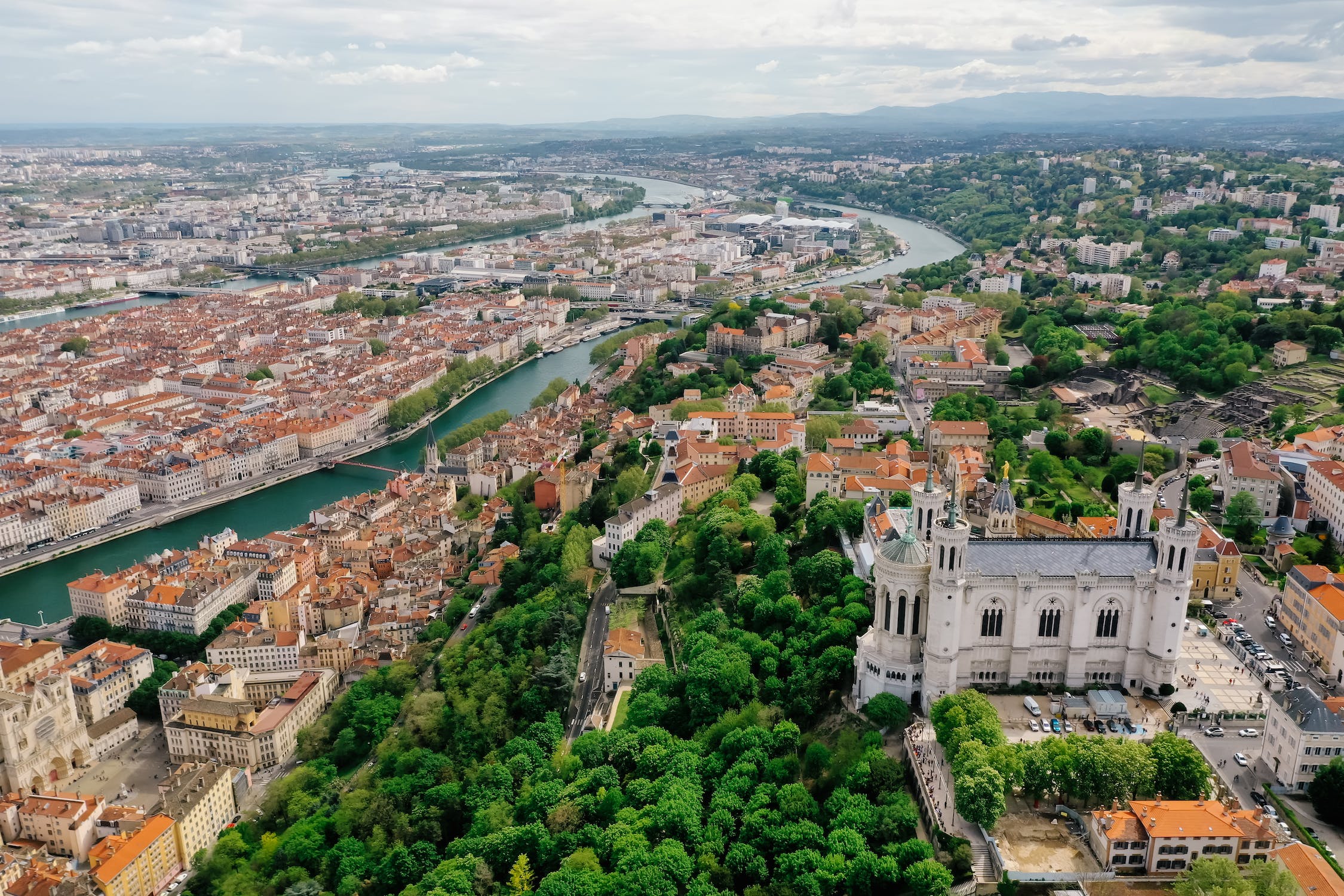
里昂(法语:Lyon,读音:/ljɔ̃/),法国第三大城市,法国东南部罗讷-阿尔卑斯大区和罗讷省的首府。位于罗纳河和索恩河交汇处。包括郊区和卫星城,里昂是仅次于巴黎的法国第二大都市区。里昂是著名的国际都市,历史悠久,部分历史和建筑地标被联合国教科文组织列为世界遗产,名称为:“里昂历史遗迹”。
里昂丝绸和纺织业源远流长,被誉为“欧洲丝绸之都”。从20世纪末期开始,里昂食品业兴起,也使得里昂有着“美食之都”的称号。里昂也是电影的诞生地,1895年卢米埃尔兄弟曾在此拍摄下世界第一部电影《工厂大门》。里昂还是国际刑警组织国际总部所在地。在2015年世界最佳居住城市评选中,里昂是位居法国第2、全球39位的最宜居城市[4]。
里昂银行业、化学、生物医药等产业实力雄厚,是法国第二大经济中心。该市教育事业发达,里昂大学是法国第二大高等教育和研究中心,里昂商学院为欧洲十强商学院和法国商学院最高学府。著名的里昂足球俱乐部也位于里昂。
[ljɔ̃] (deutsch veraltet Leyden, lateinisch Lugdunum) ist die Hauptstadt der Region Auvergne-Rhône-Alpes und der Métropole de Lyon im Südosten Frankreichs. Lyon ist ebenfalls Sitz der Präfektur des Départements Rhône, auch wenn es seit 2015 nicht mehr Teil des Départements ist.
Mit 513.275 Einwohnern in der Kernstadt (Stand: 1. Januar 2015) ist sie nach Paris und Marseille die drittgrößte Kernstadt des Landes. Die gesamte Metropolregion Lyon, mit 2.265.375 Einwohnern (Stand: 2014),[1] ist nach Paris und vor Marseille die zweitgrößte Frankreichs.
Die Altstadt Lyons und ein Teil der Halbinsel Lyon wurden 1998 von der UNESCO zum Weltkulturerbe erklärt.
Lyon ist Bischofssitz des Erzbistums Lyon der römisch-katholischen Kirche in Frankreich. Kathedralkirche ist die Kathedrale von Lyon in der Altstadt. Die Basilika Notre-Dame de Fourvière wurde in den Jahren 1872 bis 1884 auf dem Fourvière-Hügel errichtet. 2016 wurde Lyon als 61. Stadt der Ehrentitel „Reformationsstadt Europas“ durch die Gemeinschaft Evangelischer Kirchen in Europa verliehen.[2]
Die Lyoner Gastronomie genießt einen weltweiten Ruf. Die Vielfalt der traditionellen Küche findet in der seltenen Kombination aus Alpen-Nähe und schiffbarem Zugang zum Mittelmeer ihren Ursprung. Nördlich der Stadt liegt das Weinbaugebiet Beaujolais, südlich der Stadt schließen sich die Côtes du Rhône an. Historisch ist die Stadt eng mit den canuts, den Seidenwebern, verknüpft, deren Handwerk während der Industriellen Revolution die treibende Wirtschaftskraft war. Darüber hinaus ist Lyon als „Stadt des Lichtes“ bekannt, dem zu Ehren jährlich am 8. Dezember die Fête des Lumières gefeiert wird.
Lyon ist Sitz der internationalen Polizeibehörde Interpol und der Internationalen Agentur für Krebsforschung (International Agency for Research on Cancer, kurz IARC).
リヨン (Lyon) は、フランスの南東部に位置する都市で、オーヴェルニュ=ローヌ=アルプ地域圏の首府、メトロポール・ド・リヨンの県庁所在地である。1996年にサミットが行われた。1989年以降は国際刑事警察機構(インターポール、ICPO)の本部が置かれている。
リヨンの近郊にはリヨン市の人口を含め、164万8216人が住み(1999年)、都市圏としてはフランス第二の規模を持つ。
フランスにおける金融センターのひとつであり、多くのフランスの銀行の本店が置かれる。永井荷風が横浜正金銀行の社員として滞在したこともある。すでに中世からヨーロッパ各地の手形交換所として機能していた(飛脚#西洋の飛脚)。
ローマ帝国のガリア属州の植民市ルグドゥヌムとして古代から栄えた物資の集散地であり[1]、中世には市の立つ町としてヨーロッパでも有数の交易地として栄えた。また、絹織物の産地としても知られる。旧市街はユネスコの世界遺産(文化遺産)に登録されている。
Lyon (UK: /ˈliːɒ̃/,[3] US: /ˈljoʊn, liˈoʊn/,[4] also spelled Lyons and in this case alternatively pronounced /ˈlaɪənz/;[5] French: Lyon [ljɔ̃] (![]() listen); Arpitan: Liyon [ʎjɔ̃]) is the third-largest city and second-largest urban area of France. It is located in the country's east-central part at the confluence of the rivers Rhône and Saône,[6] about 470 km (292 mi) south from Paris, 320 km (199 mi) north from Marseille and 56 km (35 mi) northeast from Saint-Étienne. Inhabitants of the city are called Lyonnais.
listen); Arpitan: Liyon [ʎjɔ̃]) is the third-largest city and second-largest urban area of France. It is located in the country's east-central part at the confluence of the rivers Rhône and Saône,[6] about 470 km (292 mi) south from Paris, 320 km (199 mi) north from Marseille and 56 km (35 mi) northeast from Saint-Étienne. Inhabitants of the city are called Lyonnais.
Lyon had a population of 513,275 in 2015.[1] It is the capital of the Metropolis of Lyon and the region of Auvergne-Rhône-Alpes. The Lyon metropolitan area had a population of 2,265,375 in 2014, the second-largest urban area in France.[2] The city is known for its cuisine and gastronomy, and historical and architectural landmarks; part of it is a registered as a UNESCO World Heritage site. Lyon was historically an important area for the production and weaving of silk. Lyon played a significant role in the history of cinema: it is where Auguste and Louis Lumière invented the cinematograph. It is also known for its light festival, the Fête des Lumières, which begins every 8 December and lasts for four days, earning Lyon the title of Capital of Lights.
Economically, Lyon is a major centre for banking, as well as for the chemical, pharmaceutical, and biotech industries. The city contains a significant software industry with a particular focus on video games, and in recent years has fostered a growing local start-up sector.[7] Lyon hosts the international headquarters of Interpol, the International Agency for Research on Cancer and Euronews. It was ranked 19th globally and second in France for innovation in 2014.[8] It ranked second in France and 39th globally in Mercer's 2015 liveability rankings.
Lyon (prononcé [ljɔ̃]2 ou [liɔ̃] Écouter3 ; en francoprovençal Liyon [ʎjɔ̃]) est une commune française située dans le quart-sud-est de la France au confluent du Rhône et de la Saône. C'est la commune où siège le conseil de la Métropole de Lyon4, le chef-lieu de l'arrondissement de Lyon, de la circonscription départementale du Rhône et de la région Auvergne-Rhône-Alpes. Ses habitants s'appellent les Lyonnais.
Lyon est en situation de carrefour géographique du pays, au nord du couloir naturel de la vallée du Rhône (qui s'étend de Lyon à Marseille). Située entre le Massif central à l'ouest et le massif alpin à l'est, la ville de Lyon occupe une position stratégique dans la circulation nord-sud en Europe. Ancienne capitale des Gaules du temps de l'Empire romain, Lyon est le siège d'un archevêché dont le titulaire porte le titre de primat des Gaules. Lyon devint une ville très commerçante et une place financière de premier ordre à la Renaissance. Sa prospérité économique a été portée successivement par la soierie, puis par l'apparition des industries notamment textiles, chimiques, et plus récemment, par l'industrie de l'image.
Lyon, historiquement ville industrielle, a accueilli au sud de la ville de nombreuses industries pétrochimiques le long du Rhône, nommé le couloir de la chimie. Après le départ et la fermeture des industries textiles, Lyon s'est progressivement recentrée sur les secteurs d'activité de techniques de pointe, telles que la pharmacie et les biotechnologies. Lyon est également la deuxième ville étudiante de France, avec quatre universités et plusieurs grandes écoles. Enfin, la ville a conservé un patrimoine architectural important allant de l'époque romaine au XXe siècle en passant par la Renaissance et, à ce titre, les quartiers du Vieux Lyon, de la colline de Fourvière, de la Presqu'île et des pentes de la Croix-Rousse sont inscrits sur la liste du patrimoine mondial de l'UNESCO.
Par sa population, Lyon constitue la troisième commune de France, avec 513 275 habitants au dernier recensement de 2015. Lyon est ville-centre de la 2e unité urbaine de France, laquelle comptait 1 639 558 habitants en 2015 et de la 2e aire urbaine (2 291 763 habitants en 2015) de France. Elle est la préfecture de la région Auvergne-Rhône-Alpes et le siège de la métropole de Lyon, qui rassemble 59 communes et 1 354 476 habitants5 en 2014. La ville de Lyon exerce une attractivité d'importance nationale et européenne. Son importance dans les domaines culturels, bancaires, financiers, commerciaux, technologiques, pharmaceutiques, ou encore les arts et les divertissements font de la ville de Lyon une ville mondiale de rang « Beta- » selon le classement GaWC en 2016, comparable à Seattle, Amman ou Anvers6. Lyon est également le siège d'Interpol depuis 1989.
Lione (AFI: /liˈone/[2][3]; in francese Lyon, /ljɔ̃/) è una città della Francia sud-orientale, capoluogo della metropoli di Lione e della regione Alvernia-Rodano-Alpi.
Lione è la terza città più grande della Francia dopo Parigi e Marsiglia, ma, considerando l'area metropolitana, è seconda dopo la capitale. La città sorge alla confluenza del Rodano e della Saona ed è composta da un centro storico (Vieux-Lyon, Fourvière, Saint Jean) e da un centro più commerciale con la Place des terreaux, Place Bellecour e la Rue de la République sulla penisola tra Rodano e Saona.
I suoi abitanti si chiamano lionesi (in francese Lyonnais /ljɔ'nɛ/). Il motto della città è Avant, Avant, Lion le melhor, in lingua lionese "Avanti, avanti, Lione la migliore".
Lyon1 (en francés: Lyon ![]() [ljɔ̃] (?·i); en francoprovenzal: Liyon) es una ciudad del centro-este de Francia, capital de la Metrópoli de Lyon, del departamento del Ródano y de la región de Auvernia-Ródano-Alpes. Con 513 275 habitantes en 2015 es la tercera más poblada del país, por detrás de París y Marsella. El topónimo tradicional en español, hoy en desuso, es León de Francia para distinguirlo de la ciudad homónima sita en España.
[ljɔ̃] (?·i); en francoprovenzal: Liyon) es una ciudad del centro-este de Francia, capital de la Metrópoli de Lyon, del departamento del Ródano y de la región de Auvernia-Ródano-Alpes. Con 513 275 habitantes en 2015 es la tercera más poblada del país, por detrás de París y Marsella. El topónimo tradicional en español, hoy en desuso, es León de Francia para distinguirlo de la ciudad homónima sita en España.
Su área urbana, con 2 237 676 habitantes, es la segunda mayor del país, tras París.3 Situada al norte del corredor natural del valle del Ródano (que une Lyon con Marsella) y entre el Macizo Central al oeste y los Alpes al este, la ciudad de Lyon ocupa una posición estratégica en la circulación norte-sur en Europa.
Antigua capital de la Galia durante el Imperio romano; durante la Edad Media, Lyon se convirtió en una ciudad comercial y después en el siglo XIX en una plaza financiera de primer orden. Su prosperidad económica aumentó sucesivamente por el monopolio de la seda y luego por la aparición de industrias, sobre todo textiles y de productos químicos. Hoy en día es un importante centro industrial especializado en industrias químicas, farmacéuticas y biotecnológicas.
Lyon es la segunda ciudad universitaria de Francia, acogiendo en su área metropolitana a más de 140 000 estudiantes4 repartidos en tres universidades y numerosas escuelas de ingenieros y "grandes écoles". Además cuenta con un patrimonio histórico y arquitectónico importante, teniendo inscrita una gran superficie como Patrimonio de la Humanidad de la UNESCO.
Históricamente conocida como la capital mundial de la seda,5 afamada como una de las capitales gastronómicas de Francia entre las principales del país.
Лио́н (фр. Lyon [ljɔ̃] ![]() слушать, франкопров. Liyon [ʎjɔ̃]) — город во Франции, административный центр региона Овернь — Рона — Альпы, особого административного образования Лионская метрополия и 14 кантонов. Также является временной префектурой для департамента Рона, из состава которой был выделен с 1 января 2015 года с образованием Лионской метрополии. Третий по численности населения город Франции.
слушать, франкопров. Liyon [ʎjɔ̃]) — город во Франции, административный центр региона Овернь — Рона — Альпы, особого административного образования Лионская метрополия и 14 кантонов. Также является временной префектурой для департамента Рона, из состава которой был выделен с 1 января 2015 года с образованием Лионской метрополии. Третий по численности населения город Франции.
Согласно проведённым в 2015 году компанией PricewaterhouseCoopers исследованиям, Лион назван самым привлекательным для жизни городом Франции, обогнав Париж, Марсель и Тулузу[2].
 Geography
*World's Most Livable Cities
History
International cities
*European Capital of Culture
Geography
Geography
*World's Most Livable Cities
History
International cities
*European Capital of Culture
 Madrid
Silk road
Spain
World Heritage
Madrid
Madrid
Silk road
Spain
World Heritage
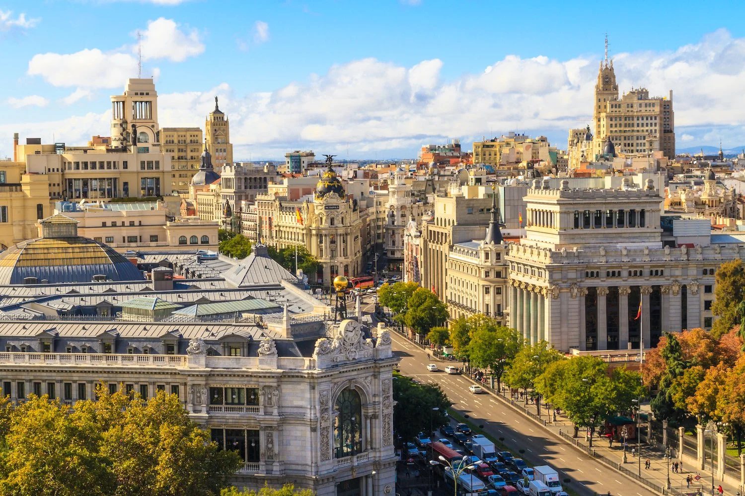
西班牙首都,第一大城市,全国经济、交通中心,马德里省首府。市区面积607平方千米,人口约310.1万,包括郊区和卫星城镇在内,面积 1020 平方千米,人口约 468.7 万。位于伊比利亚半岛梅塞塔高原中部,瓜达拉马山脉东南麓的山间高原盆地中,海拔 670 米,为欧洲地势最高的首都。地形闭塞 ,气候大陆性显著 ,降水少,气温年差较大。1月平均气温4.8℃,7月25℃,年降水量425毫米。
西班牙首都马德里(Madrid)是欧洲著名的历史古城。位于伊比利亚半岛中心,地处梅塞塔高原,海拔670米,是欧洲地势最高的首都。有人口301. 6万人(2002年)。
十一世纪前它是摩尔人的要塞,古称“马吉利特”。1561年西班牙国王菲利普二世迁都于此。十九世纪时发展为大城市。1936年至1939年西班牙内战时,曾在此进行著名的马德里保卫战。
马德里市内文物荟萃,有许多名胜古迹和世界闻名的绘画展览馆──普拉多博馆等。
市 内现代化的高楼大厦与风格迥异的古建筑摩肩并立、相映生辉。树林、草坪和各种造型别致的喷泉和雕有古代小亚细亚人尊崇的自然女神尼贝莱塑像喷泉最吸人入 胜。宏伟的阿尔卡拉门座落在阿尔卡拉街头的独立广场上,共有5道拱门,是马德里著名的古建筑之一。财政部、教育部和西班牙的主要银行座落在阿尔卡拉大街两 侧,建于1752年的王家美术学院收藏着牟利罗和戈雅等西班牙美术大师的名作。巍峨的塞万提斯纪念碑耸立在西班牙广场上,碑前有堂吉诃德和桑科·潘扎的塑 像,巨大的碑身倒映在前面的水池之中,碑两侧是葱郁的树木;有“马德里塔”之称的西班牙摩天大厦位于广场一侧。
(Quelle:http://madeli.yiji.com/postdetail_619481.html)
马德里(西班牙语:Madrid,西班牙语发音:[maˈðɾið] (ⓘ))是西班牙首都及最大都市,也是马德里自治区首府,其位置处于西班牙国土中部,曼萨纳雷斯河贯穿市区。市内人口约340万,都会区人口则约627.1万(2010年),均占西班牙首位。其建城于9世纪,是在摩尔人边贸站“马格立特”旧址上发展起来的城市;1561年,西班牙国王腓力二世将首都从托莱多迁入于此[注 1],由于其特殊的地位而得到迅速的发展,成为往后西班牙殖民帝国的运筹中心[8],现今则与巴塞罗那并列为西班牙的两大对外文化窗口。
马德里和其近郊组成的马德里大都市区为欧盟第三大城市经济体,仅次于巴黎和米兰。马德里拥有2个世界著名的足球俱乐部,皇家马德里和马德里竞技。同时,在生活水平、经济产出和市场规模方面,马德里是南欧[9][10]和伊比利亚半岛最重要的国际金融中心,同时也是欧洲和拉丁美洲之间的主要贸易通道。[11]绝大多数西班牙国内企业的总部均设在马德里,如西班牙电信、国际航空集团和西班牙国家石油公司等。一些研究机构,如西班牙皇家语言学院和薛万提斯学院;一些国际组织,如联合国下属的世界旅游组织(UNWTO)和伊比利亚美洲国家组织(OEI)等,也将总部设于马德里。
近年,各种文化活动在马德里开展。主要有西班牙国际旅游交易会(FITUR)[12],艺术博览会(ARCO)[13],马德里电脑展(SIMO TCI)[14]和马德里时装周。[15]
由于在政治、教育、娱乐、环境、大众媒体、时装、科学、文化和艺术所占据的重要地位,马德里被列为国际大都市之一。[16][17]根据Monocle杂志2017年的指数排名,马德里入选世界最佳宜居城市第10位。[18][19]
马德里是西班牙旅游人数第二多的城市,仅次于巴塞罗那。[20]虽然它拥有现代化的基础设施,但它仍完好地保留了许多历史建筑。西贝莱斯广场和喷泉已成为马德里的标志性象征。
Madrid (deutsch [maˈdʁɪt], spanisch [maˈðɾið]) ist die Hauptstadt Spaniens und der Autonomen Gemeinschaft Madrid. Die Metropolregion Madrid zählt mit etwa sieben Millionen Einwohnern zu den größten Metropolen Europas. Madrid ist (ohne Vororte) mit rund 3,2 Millionen Einwohnern nach London und Berlin die drittgrößte Stadt der Europäischen Union und die größte Stadt Südeuropas.
Madrid ist seit Jahrhunderten der geographische, politische und kulturelle Mittelpunkt Spaniens (siehe Kastilien) und der Sitz der spanischen Regierung. Hier residieren auch der König, ein katholischer Erzbischof sowie wichtige Verwaltungs- und Militärbehörden. Als Handels- und Finanzzentrum hat die Stadt nationale und internationale Bedeutung. In Madrid befinden sich sechs öffentliche Universitäten sowie verschiedene andere Hochschulen, Theater, Museen und Kultureinrichtungen.
Die Einwohner Madrids nennt man „Madrilenen“ (span. madrileños) oder „Madrider“.
マドリード(Madrid)は、スペインの首都である。マドリード州の州都であり、マドリード州の唯一の県であるマドリード県の県都でもある。
人口は約325万人。2011年の都市圏人口は541万人であり、世界第57位、欧州では第5位である[5]。 紋章はイチゴノキとクマ。
スペイン中央部のメセタ地帯のマンサナーレス川沿いに広がる。近郊にはモストレス、アルカラ・デ・エナーレス、ヘタフェなどの都市があり、マドリード首都圏を形成している。
ヨーロッパ屈指の世界都市であり、アメリカのシンクタンクが2017年に発表した総合的な世界都市ランキングにおいて、世界15位の都市と評価された[6]。
Madrid (/məˈdrɪd/, Spanish: [maˈðɾið]) is the capital of Spain and the largest municipality in both the Community of Madrid and Spain as a whole. The city has almost 3.2 million[4] inhabitants and a metropolitan area population of approximately 6.5 million. It is the third-largest city in the European Union (EU), smaller than only London and Berlin, and its monocentric metropolitan area is the third-largest in the EU, smaller only than those of London and Paris.[5][6][7][8] The municipality covers 604.3 km2 (233.3 sq mi).[9]
Madrid lies on the River Manzanares in the centre of both the country and the Community of Madrid (which comprises the city of Madrid, its conurbation and extended suburbs and villages); this community is bordered by the autonomous communities of Castile and León and Castile-La Mancha. As the capital city of Spain, seat of government, and residence of the Spanish monarch, Madrid is also the political, economic and cultural centre of the country.[10] The current mayor is Manuela Carmena from the party Ahora Madrid.
The Madrid urban agglomeration has the third-largest GDP[11] in the European Union and its influences in politics, education, entertainment, environment, media, fashion, science, culture, and the arts all contribute to its status as one of the world's major global cities.[12][13] Madrid is home to two world-famous football clubs, Real Madrid and Atlético de Madrid. Due to its economic output, high standard of living, and market size, Madrid is considered the major financial centre of Southern Europe[14][15] and the Iberian Peninsula; it hosts the head offices of the vast majority of major Spanish companies, such as Telefónica, IAG or Repsol. Madrid is the 10th most liveable city in the world according to Monocle magazine, in its 2017 index.[16]
Madrid houses the headquarters of the World Tourism Organization (UNWTO), belonging to the United Nations Organization (UN), the Ibero-American General Secretariat (SEGIB), the Organization of Ibero-American States (OEI), and the Public Interest Oversight Board (PIOB). It also hosts major international regulators and promoters of the Spanish language: the Standing Committee of the Association of Spanish Language Academies, headquarters of the Royal Spanish Academy (RAE), the Cervantes Institute and the Foundation of Urgent Spanish (Fundéu BBVA). Madrid organises fairs such as FITUR,[17] ARCO,[18] SIMO TCI[19] and the Cibeles Madrid Fashion Week.[20]
While Madrid possesses modern infrastructure, it has preserved the look and feel of many of its historic neighbourhoods and streets. Its landmarks include the Royal Palace of Madrid; the Royal Theatre with its restored 1850 Opera House; the Buen Retiro Park, founded in 1631; the 19th-century National Library building (founded in 1712) containing some of Spain's historical archives; a large number of national museums,[21] and the Golden Triangle of Art, located along the Paseo del Prado and comprising three art museums: Prado Museum, the Reina Sofía Museum, a museum of modern art, and the Thyssen-Bornemisza Museum, which completes the shortcomings of the other two museums.[22] Cibeles Palace and Fountain have become one of the monument symbols of the city.[23][24] Madrid is the most visited city of Spain.[25]
Madrid (prononcé [ma.ˈdʁid] ; en espagnol [ma.ˈðɾið]) est la capitale et la plus grande ville de l'Espagne. Située en plein cœur du royaume, elle est également la capitale et la ville la plus peuplée de la Communauté de Madrid. En tant que capitale d'État, elle abrite la plupart des institutions politiques du pays, dont le Palais royal, le siège du gouvernement et le Parlement.
Comptant une population d'environ 3,2 millions d'habitants intra-muros sur une superficie totale de 604,3 km2, au sein d'une aire urbaine d'environ 6,5 millions d'habitants en 20141, en comptant sa population intra-muros Madrid est la troisième ville de l'Union européenne , derrière Londres et Berlin.
Ville globale, elle abrite le siège de nombreuses institutions, dont l'Organisation mondiale du tourisme, l'Organisation des États Ibéro-américains, l'Académie royale espagnole et l'Institut Cervantes. Considérée comme l'une des principales places financières de l'Europe du Sud, elle partage le statut de cœur économique de l'Espagne avec Barcelone. Elle accueille le siège social des plus grandes entreprises du pays, comme Telefónica, Repsol ou Iberia.
Les bâtiments d'architecture récente côtoient des constructions de style néo-classique, telles que la porte d'Alcalá, la place de Cybèle ou la cathédrale de l'Almudena. Ville d'art, ses trois principaux musées, le musée du Prado, le musée Reina Sofía et le musée Thyssen-Bornemisza, comptent parmi les plus visités au monde2. En outre, Madrid abrite deux des plus grands clubs de football au monde, le Real Madrid et l'Atlético de Madrid.
Madrid es un municipio y ciudad de España. La localidad, con categoría histórica de villa,9 es la capital del Estado10 y de la Comunidad de Madrid. Dentro del término municipal de Madrid, el más poblado de España, viven 3 182 981 personas empadronadas, según el INE de 2017. El área metropolitana de Madrid tiene una población de 6 543 031 habitantes,11 por lo que es la tercera o cuarta área metropolitana de la Unión Europea, según la fuente, por detrás de las de París y Londres, y en algunas fuentes detrás también de la Región del Ruhr, así como la tercera ciudad más poblada de la Unión Europea, por detrás de Berlín y Londres.12131415
La ciudad cuenta con un PIB nominal de 227 411 millones USD y un PIB per cápita nominal de 34 425 USD, lo que representa un PIB PPA per cápita de 40 720 USD,16 siendo la 1.ª área metropolitana española en actividad económica; y la décima de Europa por detrás de: Londres, París, Rin-Ruhr, Ámsterdam, Milán, Bruselas, Moscú, Fráncfort del Meno y Munich. Madrid es también la ciudad española con más pernoctaciones hoteleras.17
En calidad de capital de España, Madrid alberga las sedes del Gobierno de España y sus Ministerios, de las Cortes Generales (Congreso y Senado), del Tribunal Supremo y del Tribunal Constitucional, así como la residencia oficial de los reyes de España18 y del presidente del Gobierno. En el plano económico, es la cuarta ciudad más rica de Europa, tras Londres, París y Moscú.19 Para 2009, el 50,1 % de los ingresos de las 5000 principales empresas españolas son generados por sociedades con sede social en Madrid, que suponen un 31,8 % de ellas.20 Es sede del 3.ª mayor mercado de valores de Europa,21 y 2.ª en el ámbito iberoamericano (Latibex) y de varias de las más grandes corporaciones del mundo.2223 Es la 8.ª ciudad del mundo con mayor presencia de multinacionales, tras Pekín y por delante de Dubái, París y Nueva York.2425
En el plano internacional acoge la sede central de la Organización Mundial del Turismo (OMT), perteneciente a la ONU, la sede de la Organización Internacional de Comisiones de Valores (OICV), la sede de la Secretaría General Iberoamericana (SEGIB), la sede de la Organización de Estados Iberoamericanos para la Educación, la Ciencia y la Cultura (OEI), la Organización Iberoamericana de Juventud (OIJ), y la sede de Public Interest Oversight Board (PIOB).26 También alberga las principales instituciones internacionales reguladoras y difusoras del idioma español: la Comisión Permanente de la Asociación de Academias de la Lengua Española,27 y sedes centrales de la Real Academia Española (RAE), del Instituto Cervantes y de la Fundación del Español Urgente (Fundéu). Madrid organiza ferias como FITUR, Madrid Fusión, ARCO, SIMO TCI, el Salón del Automóvil y la Cibeles Madrid Fashion Week.
Es un influyente centro cultural y cuenta con museos de referencia internacional, entre los que destacan el Museo del Prado, el Museo Nacional Centro de Arte Reina Sofía, el Thyssen-Bornemisza y CaixaForum Madrid, que ocupan, respectivamente, el 12º, 18º, 67º y 80º puesto entre los museos más visitados del mundo.28
Los orígenes de la ciudad son objeto de revisión histórica tras recientes hallazgos de enterramientos visigodos así como de restos que se remontan a los carpetanos o periodo prerromano. Las excavaciones arqueológicas también arrojan restos que se atribuyen al Madrid romano. Estos hallazgos de época visigoda han venido a confirmar que el posterior asentamiento fortificado musulmán de Maǧrīţ (del siglo IX) se había asentado sobre un vicus visigodo del siglo VII llamado Matrice o matriz, arroyo (AFI [maʤriːtˁ]).2930
No sería hasta el siglo XI cuando Madrid fue incorporada a la Corona de Castilla, tras su conquista por Alfonso VI de León en 1083. Fue designada como sede de la Corte por el rey Felipe II en 1561, convirtiéndose en la primera capital permanente de la monarquía española. Desde el Renacimiento hasta la actualidad ha sido capital de España y sede del Gobierno y la administración del Estado salvo breves intervalos de tiempo: el primero de ellos entre los años de 1601 y 1606, cuando la capitalidad pasó a Valladolid; posteriormente, de 1729 a 1733, en el llamado lustro real, la corte se trasladó a Sevilla por decisión de Isabel de Farnesio, que buscaba cura para el estado depresivo de su esposo, el rey Felipe V;31 también durante la Guerra de la Independencia la Junta Suprema Central, opuesta a José Bonaparte, se estableció en Sevilla, en 1808, y en 1810, como Consejo de Regencia, en Cádiz; finalmente, durante la Guerra Civil, aunque Madrid no dejase de ser la capital de la República conforme al artículo 5º de la Constitución española de 1931, el Gobierno republicano se trasladó en noviembre de 1936 a Valencia y a Barcelona en noviembre del año siguiente, hasta la caída de Cataluña en febrero de 1939, cuando una parte del Gobierno encabezada por su presidente, Juan Negrín, se trasladó a Alicante. El Gobierno del bando sublevado, por su parte, se estableció en Burgos y, tras finalizar la guerra, se fijó allí la capital hasta el 18 de octubre de 1939 que se volvió a trasladar a Madrid.
Мадри́д (исп. Madrid [maˈðɾið]) — столица и крупнейший город Испании, а также административный центр одноимённых провинции и автономного сообщества. Муниципалитет находится в составе района (комарки) Ареа-Метрополитана. Крупнейший экономический, политический и культурный центр страны. Население города — 3,165 млн жителей (2016).
Город расположен в центральной части Пиренейского полуострова. Большой Мадрид представляет собой агломерацию площадью 1,2 тысячи км². Сам город располагается на территории площадью 607 км² и включает 21 административный округ[2]. Крупный транспортный узел (железные, скоростные шоссейные дороги, один из крупнейших в мире аэропортов).
Мадрид — влиятельный культурный центр, в котором расположено множество музеев международного масштаба, среди которых Музей Прадо, Центр искусств королевы Софии, Музей Тиссена-Борнемисы и Форум Мадрид, находящиеся в сотне самых посещаемых музеев в мире[3].
FIFA Fussball-Weltmeisterschaft 1990
History
Italy
 Lombardia
Mailand
2026 Winter Olympics
Silk road
World Heritage
Lombardia
Mailand
2026 Winter Olympics
Silk road
World Heritage

米兰(意大利语:Milano)是欧洲国家意大利的西北方大城,也是米兰省的省会和伦巴第大区的首府,位于意大利人口最密集和发展程度最高的伦巴第平原上。它是欧洲南方的重要交通要点,历史相当悠久,以观光、时尚与建筑景观闻名于世。米兰目前有132万居民,但如果将郊区的居住人口计算在内,则超过810万人,是欧洲三大都会区之一。总面积约有1,982平方公里 ,每平方公里超过2,000人居住[2] 。目前米兰市长为Giuliano Pisapia。
市区生产总值占意大利国内生产总值的4.8%,这个地区也被称为蓝香蕉(Blue Banana),是欧洲人口最密集与工业最发达的地区[3] 。
米兰最初被凯尔特人当中的因苏布雷人(Insubres)称为Medhlan[4]。后来罗马人在西元前222年征服该地后,称它为Mediolanum。米兰因此成为罗马帝国最繁荣的地区之一,并在286年至402年成为西罗马帝国的首都。米兰在中世纪时期则被称为Mailand,德语目前依然使用这个名字,它来自于凯尔特语的Mid-lan,意为“平原中心”。拿破仑于1796年占领米兰,并于1805年将米兰当作意大利王国的首都[5][6] 。米兰随后成为受到奥地利帝国所控制的伦巴第-威尼西亚王国首都,并于1859年成为萨丁尼亚王国的一部份,逐渐隶属于意大利王国。
米兰是一个国际性及国际化的城市,有15.2%的人口出生于国外[7]。这个城市依然是欧洲主要的运输和工业中心,米兰是欧洲联盟当中第10重要的商业和金融中心(2009年)[8],其经济购买力(参见米兰经济 )位居世界第26位[9]。在2008年,米兰都会区的国内生产总值位居欧洲第七位[10]。米兰省2007年的人均国内生产总值大约为€40,000(为欧盟27国平均水平的161%),是意大利人均国内生产总值最高的省份[11],城市工人平均所得位居意大利首位[11],在世界上则排名第26位[12]。此外对于外籍员工而言,米兰是世界第11昂贵的城市[13]。根据2010年一项经济学人信息社的研究显示,米兰是全球第12昂贵的居住城市[14]。据一些研究报告显示,它的经济环境位于世界第20位,也是欧洲的第10重要的商业和金融中心[15][16],拥有价值非常高的城市品牌[17]。
米兰是公认的世界时尚和设计之都,商业、工业、音乐、体育、文学、艺术及媒体皆具有全球重要影响力,也是一个主要的全球城市[18]。全市拥有丰富的文化古迹和遗产,拥有充满活力的夜生活[19][20],并具有独特的料理,例如意大利面包和意大利调味饭,耶诞节的点心巴内多内则是米兰另一个著名的特产。蒙特拿破仑大街上的时装商店举世闻名,埃马努埃莱二世长廊被认为是世界上最古老的购物中心。米兰的音乐剧特别著名,尤其是传统歌剧,也孕育出几位重要的作曲家(例如朱塞佩·威尔第),斯卡拉大剧院也相当知名。米兰也拥有一些重要的博物馆、大学、专科院校、宫殿、教堂和图书馆,例如布雷拉美术学院和斯福尔扎古堡。两支著名的足球队伍:AC米兰和国际米兰也以这座城市为根据地。米兰在最受欢迎的欧洲旅游城市中排名第52位,在2008年共有超过1,914,000名外国旅客造访[21]。这个城市曾经举办过1906年世界博览会并将于2015年再次举办世界博览会[22]。米兰2005年7月启用的RHO新展会会场占地250万平方米,展览面积46万平方米,是世界上最大的博览会场。米兰也以阿尔法·罗密欧汽车品牌和丝绸工业著称。
Mailand (italienisch Milano [miˈlaːno], lombardisch Milan [miˈlã(ŋ)],[2] lateinisch Mediolanum) ist mit 1,3 Millionen Einwohnern die zweitgrößte Stadt Italiens und Hauptstadt der Region Lombardei sowie der Metropolitanstadt Mailand. Die Metropolregion war 2006 mit 7,4 Millionen Einwohnern der größte italienische Ballungsraum.[3]
Einst eine Gründung keltischer Siedler, erlebte die Stadt im Römischen Reich einen raschen Aufschwung. Mailand unterstand in seiner Geschichte dem Einfluss deutscher, französischer und österreichischer Kaiser und wuchs nach der Einigung Italiens zur größten Industriestadt des Landes. Sie ist heute die führende Kultur-, Medien- und Modemetropole Italiens, eine Universitätsstadt und ein internationaler Finanzplatz als Sitz der Italienischen Börse. Sie beherbergt ein Weltkulturerbe, historisch bedeutsame Bauwerke und vielfältige Kunstschätze, die mehrere Millionen Touristen pro Jahr anziehen. Die Messestadt ist dank ihrer verkehrsgünstigen Lage in der oberitalienischen Po-Ebene ein Knotenpunkt des Schienen- und Autobahnnetzes und zweitgrößtes Luftfahrtdrehkreuz Italiens mit drei internationalen Flughäfen.
ミラノ(伊: Milano)は、イタリアで最大の都市圏人口を擁する都市で、ミラノ県の県都およびロンバルディア州の州都である。ヨーロッパ有数の世界都市。イタリア語のアクセントの関係でミラーノと記されることもある。英語ではミラン(英: Milan)、フランス語ではミラン(仏: Milan)、ドイツ語ではマイラント(独: Mailand)、スペイン語ではミラン(西: Milán)、ラテン語ではメディオラーヌム(羅: Mediolanum)と言う。
ミラノはイタリア全土では首都ローマに次ぎ第2位、北部イタリアにおいては最大の都市で商業、工業、金融の中心。観光地としても名高い。1982年に1,607,804人いた人口はその後ドーナツ化現象で長く減り続けたが、ここ数年はおよそ130万人前後で落ち着いている(2013年時点の人口は1,324,169人)。2015年の近郊を含む都市圏人口は約526万人であり、イタリアで最大、南ヨーロッパではスペインのマドリードに次ぐ都市圏を形成している。日本の稚内市とほぼ同緯度に位置するが、最寒月の平均気温がおよそ5℃程度と、比較的温暖。
ミラノ・コレクションなどで知られるように古くから服飾・繊維産業などファッション関連の産業が盛んな土地柄であるが、近年は航空産業や自動車産業、精密機器工業なども発達しておりイタリア最大級の経済地域を形成している。
日本の民間研究所が2016年に発表した「世界の都市総合力ランキング」では、世界31位と評価された[4]。また、アメリカのシンクタンクが2016年に発表した世界都市ランキングでは世界45位と評価された[5]。
Milan (/mɪˈlæn, mɪˈlɑːn/;[3] Italian: Milano [miˈlaːno] (![]() listen); Lombard: Milan [miˈlãː] (Milanese variant))[4][5] is a city in northern Italy, capital of Lombardy, and the second-most populous city in Italy after Rome, with the city proper having a population of 1,369,466 while its province-level municipality has a population of 3,238,665.[6] Its continuously built-up urban area (that stretches beyond the boundaries of the Metropolitan City of Milan) has a population estimated to be about 5,270,000 over 1,891 square kilometres (730 square miles).[7] The wider Milan metropolitan area, known as Greater Milan, is a polycentric metropolitan region that extends over central Lombardy and eastern Piedmont and which counts an estimated total population of 7.5 million, making it by far the largest metropolitan area in Italy.[8][9][10][11][12] Milan served as capital of the Western Roman Empire from 286 to 402 and the Duchy of Milan during the middle and early modern age.
listen); Lombard: Milan [miˈlãː] (Milanese variant))[4][5] is a city in northern Italy, capital of Lombardy, and the second-most populous city in Italy after Rome, with the city proper having a population of 1,369,466 while its province-level municipality has a population of 3,238,665.[6] Its continuously built-up urban area (that stretches beyond the boundaries of the Metropolitan City of Milan) has a population estimated to be about 5,270,000 over 1,891 square kilometres (730 square miles).[7] The wider Milan metropolitan area, known as Greater Milan, is a polycentric metropolitan region that extends over central Lombardy and eastern Piedmont and which counts an estimated total population of 7.5 million, making it by far the largest metropolitan area in Italy.[8][9][10][11][12] Milan served as capital of the Western Roman Empire from 286 to 402 and the Duchy of Milan during the middle and early modern age.
Milan is considered a leading alpha global city,[13] with strengths in the field of the art, commerce, design, education, entertainment, fashion, finance, healthcare, media, services, research and tourism. Its business district hosts Italy's Stock Exchange and the headquarters of national and international banks and companies. In terms of GDP, it has the third-largest economy among European cities after Paris and London, but the fastest in growth among the three, and is the wealthiest among European non-capital cities.[14][15] Milan is considered part of the Blue Banana and one of the "Four Motors for Europe."
The city has been recognized as the world’s fashion capital and the world's design capital [16] thanks to several international events and fairs, including Milan Fashion Week and the Milan Furniture Fair, which are currently among the world's biggest in terms of revenue, visitors and growth.[17][18][19] It hosted the Universal Exposition in 1906 and 2015. The city hosts numerous cultural institutions, academies and universities, with 11% of the national total enrolled students.[20] Milan is the destination of 8 million overseas visitors every year, attracted by its museums and art galleries that boast some of the most important collections in the world, including major works by Leonardo da Vinci. The city is served by a large number of luxury hotels and is the fifth-most starred in the world by Michelin Guide.[21] The city is home to two of Europe's most successful football teams, A.C. Milan and F.C. Internazionale, and one of Italy's main basketball teams, Olimpia Milano.
Milan (en italien Milano, du latin Mediolanum ; en lombard Milàn) est une ville d'Italie située au nord du pays, à proximité des Alpes. Chef-lieu de la région Lombardie, située au milieu de la plaine du Pô, Milan compte approximativement 1 369 000 habitants en 2016, ce qui en fait la deuxième ville d'Italie en nombre d'habitants. En comprenant son agglomération, elle constitue toutefois la plus grande aire urbaine du pays ; avec ses 7 123 563 d'habitants en 2009, celle-ci est la quatrième aire urbaine d'Europe, après celles de Moscou, de Paris et de Londres. Région dynamique et densément peuplée, cœur industriel et poumon financier de l'Italie, elle représente la partie méridionale de la dorsale européenne1, aussi appelée « Banane bleue ».
Fondée durant l'Antiquité par des peuples celtes, les Insubres, Milan est conquise en -222 par les Romains et sera la capitale de l'Empire romain d'Occident pendant un siècle, de 286 à 402. Elle devient durant les siècles suivants un lieu majeur du christianisme, gouverné par des comtes puis par la famille Visconti, qui en font l'une des places financières les plus importantes du Moyen Âge. De 1395 à 1796, la ville forme le Duché de Milan, fief du Saint-Empire romain germanique successivement sous la domination de la France, des Habsbourg d'Espagne et de l'Autriche, avant de rejoindre en 1859 le Royaume d'Italie. Au début du XXe siècle, Milan devient la région la plus industrielle du pays et est à l'avant-garde du processus de consolidation de la jeune nation italienne. En grande partie dévastée durant la Seconde Guerre mondiale, en raison de l'occupation nazie, la ville devient le centre de la Résistance italienne. De l'après-guerre à aujourd'hui, Milan connaît une explosion démographique et économique, attirant de nombreux travailleurs du sud de l'Italie ainsi que des étrangers, faisant d'elle l'une des villes les plus cosmopolites du pays2.
Milan est considéré comme le cœur industriel, commercial, financier et universitaire de l'Italie. Siège de la Bourse italienne, elle représente un grand pôle d'attraction pour les sièges d'entreprises, notamment dans le secteur de la mode et du design, dont Milan est l'une des capitales mondiales - elle accueille notamment l'une des principales fashion weeks et le Salon international du meuble. Elle accueille par ailleurs 185 000 étudiants – soit 11 % des étudiants en Italie –, dans des établissements tels que la prestigieuse université Bocconi. Enfin, Milan est le lieu de résidence de deux grands clubs de football européens : le Milan AC et l'Inter de Milan.
Destination touristique de premier plan, avec près de deux millions de touristes chaque année3, elle abrite un patrimoine culturel important, composé de places (la Piazza del Duomo, la Piazza Mercanti), de palais construits à la Renaissance (Palais royal de Milan, Palazzo della Ragione, Casa Panigarola), de son célèbre opéra (La Scala) et de nombreux musées. Le Château des Sforza, à proximité du Parco Sempione, en accueille plusieurs. Ces bâtiments anciens en côtoient de plus récents, comme la Galleria Vittorio Emanuele II ou la tour Pirelli. Milan est la deuxième ville italienne - après Naples - étoilée au Guide Michelin4.
Milan accueille l'Exposition universelle de 2015.
Milano (/miˈlano/ ; Milàn in dialetto milanese[6], /miˈlãː/[7]) è un comune italiano di 1 369 466 abitanti[4], capoluogo della regione Lombardia, dell'omonima città metropolitana, e centro di una delle più popolose aree metropolitane d'Europa.
Fondata intorno al 590 a.C., forse con il nome di Medhelan, nei pressi di un santuario da una tribù celtica facente parte del gruppo degli Insubri e appartenente alla cultura di Golasecca, fu conquistata dagli antichi Romani nel 222 a.C. e in seguito da loro ridenominata Mediolanum. Con il passare dei secoli accrebbe la sua importanza sino a divenire capitale dell'Impero romano d'Occidente, nel cui periodo fu promulgato l'editto di Milano, che concesse a tutti i cittadini, quindi anche ai cristiani, la libertà di onorare le proprie divinità.
In prima linea nella lotta contro il Sacro Romano Impero in età comunale, divenne prima signoria per poi essere innalzata a dignità ducale alla fine del XIV secolo, rimanendo al centro della vita politica e culturale dell'Italia rinascimentale. All'inizio del XVI secolo perse l'indipendenza a favore dell'Impero spagnolo per poi passare, quasi due secoli dopo, sotto la corona austriaca: grazie alle politiche asburgiche, Milano divenne uno dei principali centri dell'illuminismo italiano. Capitale del Regno d'Italia napoleonico, dopo la Restaurazione fu tra i più attivi centri del Risorgimento fino al suo ingresso nel Regno d'Italia sabaudo.
Principale centro economico e finanziario della penisola italiana, Milano ne guidò lo sviluppo industriale, costituendo con Torino e Genova il "Triangolo industriale", in particolar modo durante gli anni del boom economico quando la crescita industriale e urbanistica coinvolse anche le città limitrofe, creando la vasta area metropolitana milanese. In ambito culturale, Milano è il principale centro italiano dell'editoria ed è ai vertici del circuito musicale mondiale grazie alla stagione lirica del Teatro alla Scala e alla sua lunga tradizione operistica. È inoltre tra i principali poli fieristici europei e del disegno industriale, ed è considerata una delle capitali mondiali della moda.
Milán (en italiano: Milano, y en dialecto milanés: Milàn)2 es la mayor Área Metropolitana de Italia y el segundo municipio de Italia por población, capital de la Ciudad metropolitana de Milán y de la región de Lombardía. Se encuentra ubicada en la llanura padana, una de las regiones más desarrolladas de Italia. En 2008, el PIB de Lombardía, fue estimado por el INSEE en 366 mil millones de euros, el segundo de Europa después de la región de Isla de Francia.[cita requerida]
Milán, como capital económica e industrial de Italia, tiene el aspecto y las características de una metrópolis moderna: rascacielos (célebre el rascacielos Pirelli, construido en 1959), edificios de cristal y metal y grandes almacenes. Su inconmensurable patrimonio artístico es uno de los mayores de Italia y de Europa, contando con cientos de iglesias monumentales antiguas y museos tan fundamentales para la historia del arte como la Pinacoteca de Brera, uno de los mayores museos de Europa, fundada en 1809 por Napoleón Bonaparte como hermano italiano del Louvre. Destaca también la obra maestra de Leonardo da Vinci, la pintura mural "La Última Cena" y los muchos monumentos románicos (sobre todo iglesias y basílicas) que hacen de Milán la capital del primer románico, llamado también Románico lombardo.
Мила́н (итал. Milano [miˈlaːno], ломб. Milan [miˈlãː], лат. Mediolanum — в центре равнины) — главный город северной части Италии. Административный центр области Ломбардия[3], самого крупного региона Италии, и провинции Милан. Второй по величине город Италии. Имеет репутацию финансово-экономической столицы страны и одной из мировых столиц моды. Относится к глобальным городам.
England
England
Manchester
History
ITU World Championship Series
Silk road
Sport
Triathlon
United Kingdom
Cities founded by the Romans
Important port
Manchester ([ˈmɛntʃɛstɐ], englisch [ˈmæntʃɪstə])[1] ist eine Stadt im Nordwesten von England im Vereinigten Königreich Großbritannien und Nordirland mit dem Status eines Metropolitan Borough sowie einer City. Sie hat etwa 570.000 Einwohner und liegt im Metropolitan County Greater Manchester, einer der größten Agglomerationen in England mit 2,9 Mio. Einwohnern (2022). Die Einwohner Manchesters werden „Mancunians“ oder verkürzt „Mancs“ genannt.
Die Ursprünge der Stadt Manchester gehen auf ein römisches Kastell am Zusammenfluss der Flüsse Irwell und Medlock zurück. Vor allem im Zeitalter der Industriellen Revolution wurde Manchester zu einem wichtigen Standort der Industrie. Einen besonderen Stellenwert nahm dabei die Textilindustrie ein, deren Anfänge in Manchester auf das Spätmittelalter zurückgehen. Im 20. Jahrhundert erfolgte der stetige Zerfall der Industrie. Heute ist Manchester dennoch eines der wichtigsten Wirtschaftszentren des Vereinigten Königreichs und beherbergt zahlreiche Museen, Hochschulen und Orte der Kunst und Kultur.
曼彻斯特市(英语:City of Manchester),即曼彻斯特(英语:Manchester),是英格兰的城市,都市自治市,位于西北英格兰区域,人口约为55万人,是曼彻斯特都市圈中人口最多的城市,且是英格兰西北第一多,英国第五多的城市。
曼彻斯特在工业革命史中有着重要位置。十八世纪,资本主义在这座城市萌芽,让本是农村地区的曼彻斯特经历急速发展并成为全世界第一座工业化的城市。全世界第一条城际通勤铁路在此诞生。因市内兴盛的纺织业,曼彻斯特在工业革命期间曾因仓库众多而闻名于世,使其获得了“仓库城市”的别称。曼彻斯特在科学技术史上也占有重要位置。成立于2002年的曼彻斯特大学及其前身见证了原子核物理学的诞生,世界上第一台存储程式电脑以及石墨烯的发现。
曼彻斯特被誉为“北方之都”[2][3],是英格兰北部一个极其重要的城市,尤其是在其经济、艺术、文化、交通运输、媒体和体育地位上。步入二十一世纪,曼彻斯特的发展愈发强势,为这座城市带来了与伯明翰竞争英国第二大城市的地位的资本[4]。
1974年,曼彻斯特与周围市镇联合组成大曼彻斯特郡,成为该郡的一个都会区。“曼彻斯特”此名常用来指整个都市区。整个大曼彻斯特的市区总人口在英国排名第二,仅次于伦敦。
マンチェスター (Manchester, IPA: [ˈmænˌtʃɪstə][ヘルプ/ファイル]) は、イングランドの北西部、グレーター・マンチェスターに位置する都市。北部イングランドを代表する都市であり、イギリスで9番目の都市である。1853年に市制(英語版)が布かれ、2011年の時点で、マンチェスター(都市と都市バラ)の人口は49万人である。2011年の近郊を含む都市圏人口は224万人であり、同国第3位である[2]。
Manchester (/ˈmæntʃɪstər, -tʃɛs-/)[5][6] is a city and metropolitan borough in Greater Manchester, England, with a population of 545,500 as of 2017.[7] It lies within the United Kingdom's third-most populous metropolitan area, with a population of 3.2 million.[8] Manchester is fringed by the Cheshire Plain to the south, the Pennines to the north and east, and an arc of towns with which it forms a continuous conurbation. The local authority is Manchester City Council.
The recorded history of Manchester began with the civilian settlement associated with the Roman fort of Mamucium or Mancunium, which was established in about AD 79 on a sandstone bluff near the confluence of the rivers Medlock and Irwell. It was historically a part of Lancashire, although areas of Cheshire south of the River Mersey were incorporated in the 20th century.[9] Throughout the Middle Ages Manchester remained a manorial township but began to expand "at an astonishing rate" around the turn of the 19th century. Manchester's unplanned urbanisation was brought on by a boom in textile manufacture during the Industrial Revolution,[10] and resulted in it becoming the world's first industrialised city.[11]
Manchester achieved city status in 1853. The Manchester Ship Canal opened in 1894, creating the Port of Manchester and directly linking the city to the Irish Sea, 36 miles (58 km) to the west. Its fortune declined after the Second World War, owing to deindustrialisation, but the IRA bombing in 1996 led to extensive investment and regeneration.[12]
In 2014, the Globalization and World Cities Research Network ranked Manchester as a beta world city, the highest-ranked British city apart from London.[13] Manchester is the third-most visited city in the UK, after London and Edinburgh.[14] It is notable for its architecture, culture, musical exports, media links, scientific and engineering output, social impact, sports clubs and transport connections. Manchester Liverpool Road railway station was the world's first inter-city passenger railway station; scientists first split the atom, developed the stored-program computer and produced graphene in the city. Manchester hosted the 2002 Commonwealth Games.
Manchester Ecoutez (ˈmanˌtʃɪstə) est une ville du Royaume-Uni située dans le comté métropolitain du Grand Manchester. Elle a le statut de cité depuis 1853 et compte 545 500 habitants en 2017. Elle est parfois considérée comme la « deuxième ville d’Angleterre » grâce à son importance économique, culturelle et sportive1, bien que sa superficie et sa population ne lui permettent pas de détrôner Birmingham. Manchester est catégorisée comme une ville « bêta » par Le GaWC (Réseau d’étude sur la mondialisation et les villes mondiales2). Ses habitants s'appellent les Mancunien(ne)s. La ville est au cœur d'une grande agglomération de plus de deux millions et demi d'habitants dont les villes principales sont : Bury, Bolton, Rochdale, Oldham, Ashton-under-Lyne, Stockport, Salford, Altrincham, Wigan. Le nom de « Manchester » est utilisé aussi bien pour désigner l'agglomération que la ville en tant que telle.
Manchester est située à 260 km au nord-ouest de Londres, sur la rive est de la rivière Irwell. La ville est bordée au Sud par la plaine du Cheshire et au Nord et à l'Est par la chaîne montagneuse des Pennines. Historiquement, la majeure partie de la ville faisait partie du Lancashire, mais des zones situées au sud de la rivière Mersey appartenaient au Cheshire. Le vicus créé par les Romains à proximité du fort de Mamucium, construit en 79 sur un monticule rocheux non loin de la confluence entre la Medlock et l'Irwell, est devenu au fil de son histoire une ville majeure du nord de l'Angleterre. Manchester est la première ville au monde à avoir été industrialisée, et elle a joué un rôle important durant la révolution industrielle. Durant le XIXe siècle, la ville acquiert d'ailleurs le surnom de « Cottonopolis » en raison de son importante industrie cotonnière. L'économie de la ville s'est depuis tournée vers le secteur tertiaire, et il s'agit aujourd'hui d'un pôle financier important.
Manchester est une ville importante culturellement, qui héberge de nombreux théâtres, musées et salles de concert. La ville a vu dans les années 1980 l'émergence de divers groupes de rock indépendant autour du club The Haçienda, qui deviendront très célèbres par la suite et que l'on regroupe sous l'appellation « Madchester ». Elle a une économie nocturne bien développée avec de nombreux bars et clubs. La ville est le siège de divers médias, dont de nombreuses stations de radios, des journaux et une importante base de la BBC. L'architecture de la ville est marquée par l'omniprésence des briques rouges. Elle mêle des bâtiments historiques, comme la cathédrale gothique, des édifices de l'époque victorienne et de la période industrielle, avec des bâtiments à l'architecture contemporaine, dont de hauts gratte-ciel. Manchester est la troisième ville la plus visitée par les étrangers au Royaume-Uni.
Manchester est également une importante ville étudiante avec ses deux universités, l'université de Manchester et l'université métropolitaine de Manchester qui, avec entre-autres le Royal Northern College of Music, regroupent plus de 70 000 étudiants.
La ville accueillit en 2002 les jeux du Commonwealth. Elle se démarque également dans le monde sportif par ses deux équipes de Premier League de football, Manchester United et Manchester City.
Manchester (AFI: /ˈmanʧester/[3]; in inglese [ˈmantʃɪstə][4]), in italiano antico Mancunia, è un borgo metropolitano di 503.127 abitanti del Regno Unito, che gode del titolo onorifico di città, ed è capoluogo della contea metropolitana inglese della Greater Manchester. Insediamento celtico poi rinominata dagli antichi romani magna castra, i suoi abitanti vengono chiamati Mancunians (Mancuniani).
Mánchester1 (pronunciado en inglés  /ˈmæntʃɛstə/ (?·i)) es una ciudad y un municipio metropolitano del condado de Gran Mánchester en Inglaterra. Mánchester obtuvo su estatus de ciudad en 1853 y tenía una población estimada de 530.300 habitantes en 2015.2 A su vez, forma parte de la segunda aglomeración urbana del Reino Unido y decimocuarta de la Unión Europea en términos de población.
Mánchester es un importante centro artístico, financiero, de medios de comunicación y de educación superior. En una encuesta de líderes empresariales británicos publicada en 2006, Mánchester era considerada como el mejor lugar en el Reino Unido para establecer un negocio. Un informe encargado por la Asociación de Mánchester, publicado en 2007, mostró a Mánchester como la "ciudad con más rápido crecimiento económico". Es la tercera ciudad más visitada en el Reino Unido por turistas extranjeros. Mánchester fue la anfitriona de los Juegos de la Mancomunidad de 2002, y es sede de dos equipos de fútbol de la Premier League, Manchester United y Manchester City.
Históricamente la mayor parte de la ciudad fue parte del condado de Lancashire, con las zonas ubicadas al sur del río Mersey en el condado de Cheshire. Mánchester fue la primera ciudad industrializada del mundo y desempeñó un papel central durante la Revolución industrial. Se convirtió en el principal centro internacional de la fabricación textil y de hilado de algodón. Durante el siglo XIX adquirió el apodo de "Cottonopolis", sugiriendo que era una metrópoli de las fábricas de algodón. El centro de la ciudad se encuentra en una lista provisional del Patrimonio de la Humanidad de la Unesco, debido principalmente a la red de canales y molinos construidos durante los siglos XVIII y XIX.
Манче́стер[2] (англ. Manchester ['mænʧɪstə]) — город и метрополитенский район в Северо-Западной Англии, графство Большой Манчестер. Менее чем полумиллионный город имеет крупнейшую в регионе 2,2-миллионную агломерацию Большой Манчестер. Девятый по величине город Великобритании (и восьмой — Англии).
Наряду с Бирмингемом, Лидсом, Шеффилдом, Ливерпулем и Лондоном Манчестер был одним из центров Промышленной революции. В настоящее время Манчестер — крупный культурный, промышленный, финансовый, коммерческий и транспортный центр страны. Развито машиностроение, текстильная, химическая, лёгкая, бумажная промышленность. Действует морской порт. Манчестерский университет является одним из самых престижных в Великобритании. Имеется городской музей и художественная галерея[3].

马尼拉(他加禄语:Maynila,英语:Manila),又称岷里拉,是菲律宾首都,位于小菲律宾的最大岛—吕宋岛马尼拉湾的东岸;今为菲第二大城,人口有150万;乃全国经济、文化、教育和工业中心。2013年4月,马尼拉都会人口排名全球第6名,达2120万人[1]。
在同属此都会区的众多城市中,仅奎松市人口多于马尼拉市。马尼拉之名在西班牙殖民时,因双方语言不通的误解而命名为:Maynilad,起源于他加禄语:May是这里有的意思,他加禄语:nilad(瓶花木属)是一种生长着白艳花朵、可作为染料的湿地树,许多观赏过的人们都以“那些白色的花开着,便像一双双亮晶晶的眼睛”形容它,两字合起来为他加禄语:Maynilad,本意为他加禄语的这里有白色的花。[2][3]她所属的这个都会区,菲律宾官方称为马尼拉大都会(Metro Manila),一般外国人和非定居者通常简称以马尼拉。全区由17座城市和直辖市所组成。
Manila ([maˈniːla], offiziell englisch City of Manila, Tagalog Lungsod ng Maynila) ist die Hauptstadt der Republik der Philippinen.
Manila liegt auf der Hauptinsel Luzon in der Manilabucht. Sie ist eine von 17 Städten und Gemeinden, die zusammen die 636 Quadratkilometer große Region Metro Manila bilden. Die Stadt Manila zählt rund 1,8 Millionen Menschen, in der Agglomeration Metro Manila wohnen rund 12,9 Millionen Einwohner (1. August 2015).[2] Häufig wird die gesamte Metropolregion als Manila bezeichnet, was jedoch im administrativen Sinne falsch ist.
Die Hauptstadt ist das politische, wirtschaftliche und kulturelle Zentrum des Landes sowie Verkehrsknotenpunkt mit Universitäten, Hochschulen, Theater und Museen. Die Schutzpatronin der Stadt ist die La Naval de Manila.
マニラ市(タガログ語: Maynilà [majˈnilaʔ]、英語: Manila [məˈnɪlə])は、フィリピン共和国の首都。メトロ・マニラとも呼ばれるマニラ首都圏に所属する都市。フィリピンのルソン島中西部にあり、マニラ湾東岸に位置している。
『東洋の真珠』などの美称があり、フィリピンがスペイン人によって植民地化された16世紀末よりフィリピンの首府であり、独立後も一貫して首都でありつづけている。市域人口は166万人(2007年)であり、人口1,155万人を抱えるメトロ・マニラの中核都市である。さらに近郊を含む都市圏人口は2016年時点で2,293万人であり、世界有数の大都市圏を形成している[1]。
アメリカのシンクタンクが2017年に発表した総合的な世界都市ランキングにおいて、世界66位の都市と評価された[2]。東南アジアでは、シンガポール、バンコク、クアラルンプール、ジャカルタに次ぐ5位である。
Manila (/məˈnɪlə/; Tagalog: Maynilà, pronounced [majˈnilaʔ]), officially the City of Manila (Tagalog: Lungsod ng Maynilà [luŋˈsod nɐŋ majˈnilaʔ]), is the capital of the Philippines and a highly urbanized city. It is the most densely populated city proper in the world as of 2019.[11] It was the first chartered city by virtue of the Philippine Commission Act 183 on July 31, 1901 and gained autonomy with the passage of Republic Act No. 409 or the "Revised Charter of the City of Manila" on June 18, 1949.[12] Manila, alongside Mexico City and Madrid are considered the world's original set of Global Cities due to Manila's commercial networks being the first to traverse the Pacific Ocean, thus connecting Asia with the Spanish Americas, marking the first time in world history when an uninterrupted chain of trade routes circled the planet.[13] Manila is also the second most natural disaster-afflicted capital city in the world next to Tokyo,[14] yet it is simultaneously among the most populous and fastest growing cities in Southeast Asia.[15]
The Spanish city of Manila was founded on June 24, 1571, by Spanish conquistador Miguel López de Legazpi. The date is regarded as the city's official founding date; however, a Tagalog fortified polity called Maynilà had already existed on the site, dating back as far as 1258, from which the Spanish and English name of 'Manila' was derived. A Spanish fortified city called Intramuros was built directly on top of the site of old Maynilà, following the defeat of the polity's last indigenous Rajah, Sulayman III, in the Battle of Bangkusay. Manila was the seat of power for most of the country's colonial rulers. It is home to many historic sites, some of which were built during the 16th century. Manila has many of the Philippines' firsts, including the first university (1590),[16] light station (1642), lighthouse tower (1846), water system (1878), hotel (1889), electricity (1895), oceanarium (1913),[17] stock exchange (1927), flyover (1930s), zoo (1959), pedestrian underpass (1960),[18] science high school (1963),[19] city-run university (1965), city-run hospital (1969), and rapid transit system (1984; also considered as the first rapid transit system in Southeast Asia).[20]
The term "Manila" is commonly used to refer to the whole metropolitan area, the greater metropolitan area or the city proper. The officially defined metropolitan area called Metro Manila, the capital region of the Philippines, includes the much larger Quezon City and the Makati Central Business District. It is the most populous region of the country, one of the most populous urban areas in the world,[21] and is one of the wealthiest regions in Southeast Asia.[22] The city proper is home to 1,780,148 people in 2015,[6] and is the historic core of a built-up area that extends well beyond its administrative limits. With 71,263 people per square kilometer, Manila is also the most densely populated city proper in the world.[6][7]
Manille, officiellement la Ville de Manille (en tagalog Lungsod ng Maynila; en filipino Maynila; en anglais City of Manila) est la capitale des Philippines, et l'une des 16 villes de l'aire métropolitaine de Manille, l'une des plus peuplées au monde. Cette dernière, qui se trouve sur la côte ouest de l'île de Luçon, constitue le Grand Manille (NCR ou Metro Manila), et ne fait partie d'aucune province du pays. Elle se trouve sur la rive orientale de la baie de Manille. Les villes voisines sont Navotas et Caloocan au nord, Quezon au nord-est, San Juan et Mandaluyong à l'est, Makati au sud-est et Pasay au sud.
Avec 1 660 714 habitants d'après le recensement de 2007, Manille est la deuxième ville des Philippines, par sa population, après Quezon. Cette population, concentrée sur une superficie d'à peine 38,55 km2, fait de Manille, la ville la plus dense au monde2. La région métropolitaine de Manille est l'aire urbaine la plus peuplée des Philippines et la onzième au monde avec une population estimée à 16 300 000. La mégapole est la douzième plus grande au monde et sa population est estimée à 19 888 419 habitants3.
La ville est divisée en six districts législatifs et seize districts géographiques : Binondo (en), Ermita (en), Intramuros, Malate (en), Paco (en), Pandacan (en), port de Manille, Quiapo (en), Sampaloc (en), San Andres (en), San Miguel (en), San Nicolas (en), Santa Ana (en), Santa Cruz (en), Santa Mesa (en) et Tondo. À l'intérieur de leurs quartiers, on peut trouver des aires de commerces animés et la plupart des points historiques et culturels les plus importants comme le palais de Malacañan résidence officielle du président des Philippines et le siège du Départements exécutifs des Philippines. C'est le siège d'institutions scientifiques et éducatives, mais aussi de nombreux équipements sportifs. Tout cela fait de la ville un centre politique, commercial, culturel, éducatif, religieux et des transports majeur des Philippines.
Manila (AFI: /maˈnila/[2]; in filippino Maynila, nome completo Lungsod ng Maynila) è la capitale delle Filippine. È situata sulla costa est della baia di Manila sulla più grande delle isole delle Filippine, Luzón. Nonostante le sacche di povertà presenti, è una delle città più cosmopolite del mondo e la sua area metropolitana è il centro economico, culturale ed industriale del paese.
È il centro di una prosperosa area metropolitana con oltre 12 milioni di abitanti; l'area di Metro Manila, alla quale la città di Manila appartiene, è un'enorme metropoli costituita da 17 città e municipalità; la città stessa, con il suo milione e mezzo di abitanti, è la seconda città più popolosa delle Filippine. Soltanto Quezon, un'area suburbana nonché precedente capitale del Paese, è più popolosa.
Nacque nel XVI secolo da una colonia musulmana chiamata May Nilad sulle rive del fiume Pasig nella sede del governo coloniale spagnolo che controllò le Filippine per 333 anni. Nel 1898 gli Stati Uniti occuparono e presero il controllo dell'arcipelago fino al 1935 e Manila divenne una delle più note città dell'oriente. Durante la Seconda guerra mondiale, gran parte della città venne distrutta, ma in seguito venne ricostruita. Nel 1975, per gestire meglio quanto avveniva nella regione in rapido sviluppo, la città di Manila e i paesi e città nei dintorni vennero incorporati in un'entità indipendente, Manila Metropolitana. Questo venne stabilito l'8 novembre 1975 mediante il decreto presidenziale numero 824 dal precedente presidente Ferdinand Marcos che creava la "Metropolitan Manila Commission", diventata poi la Metro Manila Development Authority. Oggi la città e l'area metropolitana costituiscono un importante centro economico e culturale, ma esistono grossi problemi legati alla sovrappopolazione, traffico, inquinamento e criminalità.
Manila (en inglés: ![]() [ məˈnɪlə ]; en tagalo: Maynila
[ məˈnɪlə ]; en tagalo: Maynila ![]() [ majˈnilaʔ ]; en pampango: Menila; en zambal: Ibali) es la capital de las Filipinas y la segunda ciudad del país por número de habitantes.
[ majˈnilaʔ ]; en pampango: Menila; en zambal: Ibali) es la capital de las Filipinas y la segunda ciudad del país por número de habitantes.
La ciudad está situada en la costa oriental de la bahía de Manila, en la isla de Luzón, junto a la desembocadura del río Pásig; la ciudad limita al norte con las ciudades de Navotas y Caloocan; al nordeste con Ciudad Quezón; al este con San Juan y Mandaluyong; al sudeste con Makati y al sur con Pasay.
Manila tiene una población total de 1 652 171 de acuerdo con el censo de 2013,1 siendo la segunda ciudad más poblada del país después de la cercana Ciudad Quezón. La población habita un área de apenas 38,55 kilómetros cuadrados (14,88 mi²), lo que hace a Manila una de las ciudades más densamente pobladas del mundo.2 El Gran Manila es el área metropolitana más poblada de toda Filipinas y la décima del mundo, con una población estimada en 20,5 millones.3
La ciudad se divide en seis distritos legislativos y consiste en dieciséis distritos geográficos: Binondo, Ermita, Intramuros, Malate, Paco, Pandacán, Port Area, Quiapo, Sampaloc, San Andrés, San Miguel, San Nicolás, Santa Ana, Santa Cruz, Santa Mesa y Tondo. El comercio más activo y algunos de los lugares más históricos y emblemáticos de gran importancia cultural en el país, como la sede del Ejecutivo filipino y la Suprema Corte de las Filipinas, se encuentran en esta ciudad. Manila es sede de varias instituciones científicas y educativas, numerosas instalaciones deportivas, así como de un amplio elenco de entidades culturales del país y otros lugares cultural e históricamente significativos.
El primer relato escrito acerca de la ciudad es la Inscripción de la Laguna Copperplate, que data del siglo X. La ciudad fue invadida por Bolkiah, sultán de Brunéi, y fue cristianizada ya en el siglo XVI, cuando los conquistadores españoles llegaron por primera vez. Fue incorporada el 24 de junio de 1571 por el conquistador español Miguel López de Legazpi. Manila se convirtió finalmente en el centro de las actividades españolas en el Lejano Oriente y destino de la ruta comercial del Galeón de Acapulco a Manila, el cual conectaba a la América Española con Asia. La ciudad recibió el apodo de la "Perla de Oriente", como resultado de su ubicación central en las vitales rutas del comercio marítimo por el Pacífico. Varias insurrecciones chinas, revueltas locales, una ocupación británica y un motín cipayo se produjeron tiempo después de eso. Manila también vio el surgimiento de la Revolución filipina, que fue seguida por la ocupación estadounidense, contribuyendo a la planificación urbana de la ciudad y al desarrollo sólo para que la mayoría de dichas mejoras se perdiera por la devastación de la Segunda Guerra Mundial. Después de esto, la ciudad ha sido reconstruida.
Мани́ла (тагальск. Maynila, Майнила[1]; англ. и исп. Manila) — столица государства Филиппины, один из 16 городов, формирующих Столичный Регион страны (Метро-Манила). Граничит с городами Навотас и Калоокан (на севере), Кесон-Сити (на северо-востоке), Сан-Хуан и Мандалуйонг (на востоке), Макати (на юго-востоке) и Пасай (на юге). На западе омывается водами Манильского залива. С населением 1 660 714 человек по данным переписи 2007 года, Манила — второй крупнейший город страны после Кесона. Имея площадь всего 38,55 км², Манила считается самым густонаселённым городом мира[источник не указан 990 дней].
FIFA Fussball-Weltmeisterschaft 1998
France
UEFA European Championship 2016
International cities
*European Capital of Culture
 2024 Summer Olympics
 Provence-Alpes-Côte d´Azur
Silk road
Important port
Provence-Alpes-Côte d´Azur
Silk road
Important port

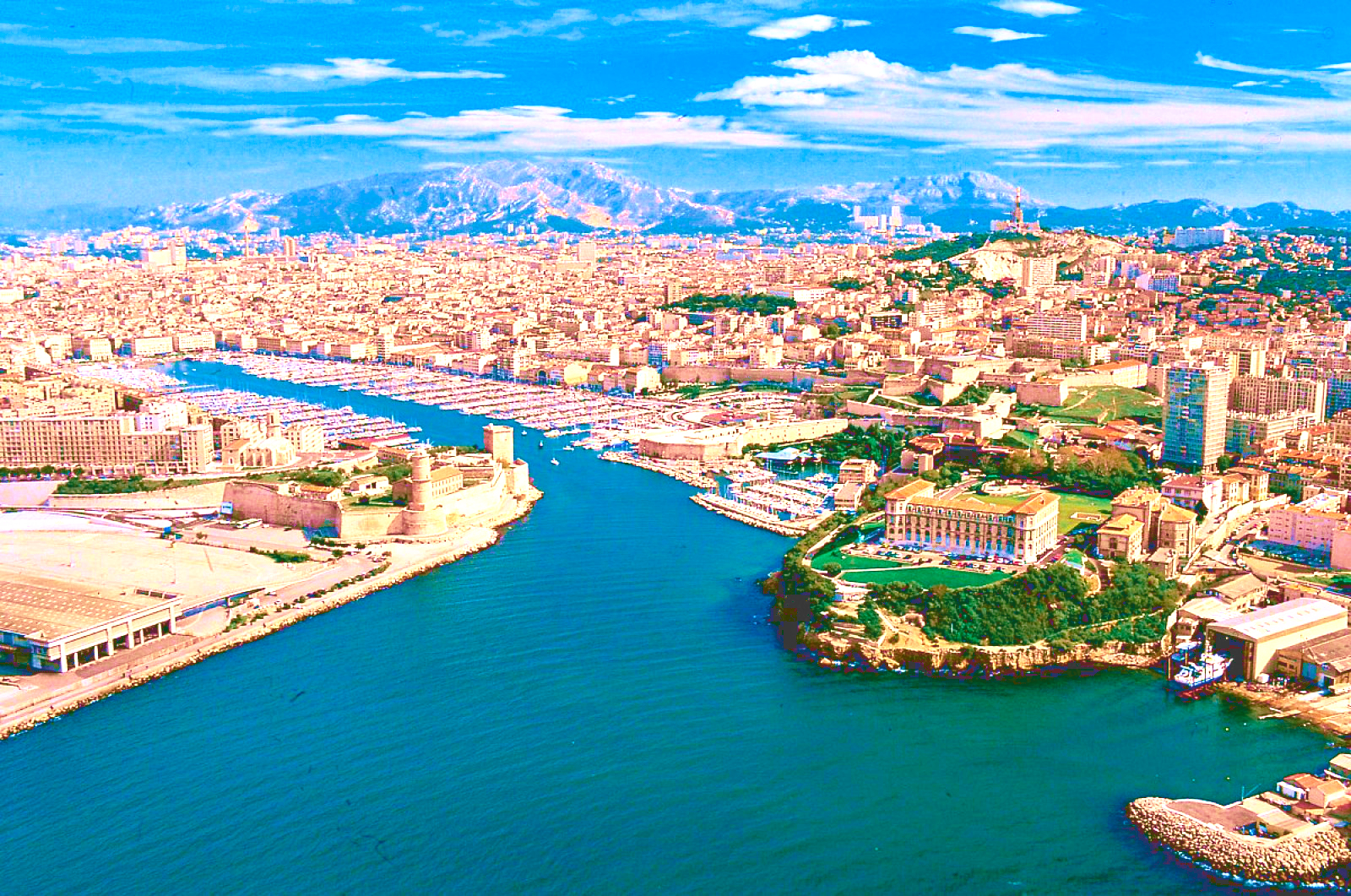
马赛(Marseille)是法国的第二大城市和最大海港,城市人口123万。该市三面被石灰岩山丘所环抱,景色秀丽, 气候宜人。马赛东南濒地中海,水深港阔,无急流险滩,万吨级轮可畅通无阻;西部有罗纳河及平坦河谷与北欧联系,地理位置得天独厚。全港由马赛、拉韦拉、福 斯和罗纳圣路易四大港区组成,年货运量1亿吨,为法国对外贸易最大门户。马赛是法国的一个重要工业中心,这里集中了法国40%的石油加工工业,福斯-塔尔 泊一带有4个大型炼油厂,每年能处理石油4500万吨。马赛的修船工业也相当发达,其修船量占全国此行业的70%。新港区有大小船坞10个,其中第10号 船坞长465米,宽65米,深11~12.5米,能修理世界最大的船只--80万吨级的油轮。
马赛(法语:Marseille,法语发音:[maʁsɛj] (ⓘ);奥克语:Marselha),法国东南部城市,普罗旺斯-阿尔卑斯-蓝色海岸大区罗讷河口省的一个市镇,同时也是所在大区首府及所在省的省会,下辖马赛区[1],2021年1月1日时人口数量为873,076人,在法国城市中排名第二位,仅次于首都巴黎,并与相邻的普罗旺斯地区艾克斯以及周边的数十个市镇共同组成了艾克斯-马赛普罗旺斯都会区[2]。
马赛位于地中海沿岸,市区三面环山、一面靠海,城市自老港向内陆区域延伸,市镇面积达240.6平方公里。马赛是法国艺术与历史之城,公元前六世纪就已有建城记载,被认为是法国最古老的城市之一。马赛在中世纪时为重要的宗教中心,近代因港口而吸引了大批移民,现为法国南部的政治、经济、科教、医疗、文化中心,艾克斯-马赛大学是法国乃至法语区规模最大的高等教育机构。马赛是世界水资源协会的总部所在地,是法国最大的港口城市,在2014年以前,马赛亦是地中海沿岸最大的港口[社 1]。
马赛是法国重要的旅游城市,因当地温暖的气候和充足的日照而闻名,被称为“阳光大道”的法国A7高速公路直通马赛市中心,市区内亦有大量历史建筑。马赛也因同名足球俱乐部而闻名,后者是法国唯一一个获得欧洲冠军联赛总冠军的球队,此外齐内丁·齐达内的标志性的过人动作被称为“马赛回旋”。在艺术方面,法国作家安托南·阿尔托和埃德蒙·罗斯丹出生于马赛,另有大批文学及影视作品取材于此。2013年,马赛获得“欧洲文化之都”的称号。
Marseille (/mɑːrˈseɪ/; French: [maʁsɛj] (![]() listen), locally [mɑχˈsɛjə]; English alternative spelling: Marseilles; Provençal: Marselha [maʀˈsejɔ, -ˈsijɔ]), is the second-largest city of France. The capital of the Bouches-du-Rhône department and Provence-Alpes-Côte d'Azur administrative region, it is on France's south coast and had a population of 852,516 in 2012.[1] It has a metropolitan area of 241 km2 (93 sq mi), the third-largest in France after Paris and Lyon.[3]
listen), locally [mɑχˈsɛjə]; English alternative spelling: Marseilles; Provençal: Marselha [maʀˈsejɔ, -ˈsijɔ]), is the second-largest city of France. The capital of the Bouches-du-Rhône department and Provence-Alpes-Côte d'Azur administrative region, it is on France's south coast and had a population of 852,516 in 2012.[1] It has a metropolitan area of 241 km2 (93 sq mi), the third-largest in France after Paris and Lyon.[3]
Known to the ancient Greeks and Romans as Massalia[4] (Greek: Μασσαλία, Massalía),[5][page needed][6] Marseille was an important trading centre and the main commercial port of the French Republic. Marseille is now France's largest city on the Mediterranean coast and the largest port for commerce, freight and cruise ships. The city was European Capital of Culture in 2013. It hosted matches at the 1998 World Cup and Euro 2016. It is home to Aix-Marseille University.
Marseille [maʁˈsɛj] (deutsch veraltet: Massilien, okzitanisch: Marselha oder Marsiho [maʀˈse.jɔ]) ist die wichtigste französische und eine bedeutende europäische Hafenstadt. Sie liegt am Golfe du Lion, einer Mittelmeerbucht. Die Stadt, deren Einwohner sich Marseillais [maʁ.sɛ.ˈjɛ] nennen, ist Hauptstadt des Départements Bouches-du-Rhône in der Region Provence-Alpes-Côte d’Azur. Marseille ist mit 861.635 Einwohnern (Stand 1. Januar 2015) nach Paris die zweitgrößte Stadt Frankreichs. Die Metropolregion zählt nach Eurostat-Definition rund 3,05 Mio. Einwohner (2015).[1]
Marseille war 2013 gemeinsam mit der slowakischen Stadt Košice Kulturhauptstadt Europas.
Marseille1 (en occitan provençal : Marselha selon la graphie classique, Marsiho selon la graphie mistralienne2) est une commune du Sud-Est de la France, chef-lieu du département des Bouches-du-Rhône et de la région Sud Provence-Alpes-Côte d'Azur.
En 2015, Marseille est la deuxième commune de France, avec 861 635 habitants3 et la troisième agglomération avec 1 578 584 habitants4. Depuis le 1er janvier 2016, Marseille est le siège de la métropole d'Aix-Marseille-Provence5, la seconde plus peuplée de France avec 1 859 922 habitants6. Son aire urbaine est quant à elle la troisième de France après celles de Paris et Lyon avec 1 752 398 habitants en 20157.
Parmi les plus anciennes villes de France8, fondée sous le nom de Μασσαλία (Massalía) vers 600 av. J.-C. par des marins grecs originaires de Phocée, Marseille est depuis l'Antiquité un important port de commerce et de passage. Elle connait notamment un essor commercial considérable au cours du XIXe siècle devenant une ville industrielle et négociante prospère9.
Héritage de ce passé, le Grand port maritime de Marseille (GPMM) et l'économie maritime sont encore des pôles majeurs de l'activité régionale et nationale10 et Marseille reste le premier port français, le deuxième port méditerranéen11 et le cinquième port européen12.
L'ouverture de Marseille sur la mer Méditerranée en fait depuis ses origines une ville cosmopolite d'échanges culturels et économiques avec l'Europe du Sud, le Proche-Orient, l'Afrique du Nord et l'Asie. Elle est d'ailleurs souvent considérée comme la « Porte de l'Orient »13.
Marsiglia (in francese: Marseille [maʁ.sɛij(ə)], in provenzale: Marselha o Marsiho[Nota 1], in latino: Massilia o Massalia; in greco: Μασσαλία o Μασαλία) è la più grande città della Francia meridionale, capoluogo della regione Provenza-Alpi-Costa Azzurra e del dipartimento delle Bocche del Rodano, oltre che il primo porto della Francia, sesto del Mediterraneo ed a livello europeo[1]. Fondata dai Greci durante l'Antichità, è una delle più antiche città francesi. Considerando il numero di abitanti della sola municipalità risulta essere la seconda città della Francia, dopo Parigi. In realtà Lione, pur avendo meno abitanti di Marsiglia nel territorio comunale, considerando l'area metropolitana supera il milione e mezzo di abitanti, contendendo a Marsiglia il primato di seconda città di Francia.
Marsiglia è stata Capitale europea della cultura nel 2013, assieme a Košice.
Marsella (Marseille en francés ![]() [maʁ.sɛj] (?·i), del griego Μασσαλία, Massalia; en occitano provenzal, Marselha o Marsiho) es una ciudad portuaria del sur de Francia, capital del departamento de Bocas del Ródano y de la región de Provenza-Alpes-Costa Azul.
[maʁ.sɛj] (?·i), del griego Μασσαλία, Massalia; en occitano provenzal, Marselha o Marsiho) es una ciudad portuaria del sur de Francia, capital del departamento de Bocas del Ródano y de la región de Provenza-Alpes-Costa Azul.
Marsella es la segunda ciudad más poblada de Francia después de París con 859 543 habitantes, principal centro económico y mayor metrópoli del Mediodía francés, agrupando cerca de 1 605 000 habitantes en su área urbana, siendo la tercera mayor del país, tras París y Lyon. Es el puerto comercial más importante de Francia y del Mediterráneo, tercero en importancia de Europa tras Róterdam y Amberes, centro de importante actividad industrial especializado en la petroquímica y el refino de petróleo, construcción naval e industrias diversas, es también un nudo de comunicaciones en el que confluyen las rutas entre París, Italia, Suiza y España. Marsella es sede de una Archidiócesis y centro universitario de primer orden fundado en 1409.
Marsella se desarrolló con el nombre de Massalia como colonia comercial fundada por marineros focenses hacia el 600 a. C., conservando los restos más antiguos de la viticultura de Francia introducidos en el siglo IV a. C.. Sede de un vizcondado en el siglo IX dependiente luego del condado de Provenza, fue incorporada a la corona de Francia en 1481 y aprovechó para su crecimiento de la alianza estratégica de ésta con el Imperio otomano durante el Renacimiento y el Antiguo Régimen. Tras la Revolución que bautizó con el nombre de Marsellesa, la marcha militar que más tarde se convirtió en uno de los símbolos nacionales de Francia, la ciudad fue escenario del llamado Terror Blanco y durante el siglo XIX, escenario de un rápido progreso con la expansión colonial francesa hacia Argelia y la apertura del canal de Suez. Fue parcialmente destruida durante la Segunda Guerra Mundial y uno de los objetivos de la Operación Dragoon. Lugar de paso tradicional de los flujos migratorios que fueron incrementando el carácter multicultural de la ciudad, la crisis económica de los años 1970 provocó sin embargo un descenso notable de la población, la pérdida de poder adquisitivo y la acentuación de los conflictos sociales en el último cuarto del siglo XX para ir recuperándose paulatinamente como una de las urbes más importantes de la región Euromediterránea.
 *Moscow
Eurovision Song Contest,ESC
FIFA Fussball-Weltmeisterschaft 2018
FIFA Fussball-Weltmeisterschaft 2018
Group A
FIFA Fussball-Weltmeisterschaft 2018
Group F
FIFA Fussball-Weltmeisterschaft 2018
Group B
FIFA Fussball-Weltmeisterschaft 2018
Group C
FIFA Fussball-Weltmeisterschaft 2018
Group D
FIFA Fussball-Weltmeisterschaft 2018
Group H
FIFA Fussball-Weltmeisterschaft 2018
Group G
FIFA Fussball-Weltmeisterschaft 2018
Group E
History
Olympic Summer Games
Russia
Silk road
Shanghai Cooperation Organization
World Heritage
*Moscow
Eurovision Song Contest,ESC
FIFA Fussball-Weltmeisterschaft 2018
FIFA Fussball-Weltmeisterschaft 2018
Group A
FIFA Fussball-Weltmeisterschaft 2018
Group F
FIFA Fussball-Weltmeisterschaft 2018
Group B
FIFA Fussball-Weltmeisterschaft 2018
Group C
FIFA Fussball-Weltmeisterschaft 2018
Group D
FIFA Fussball-Weltmeisterschaft 2018
Group H
FIFA Fussball-Weltmeisterschaft 2018
Group G
FIFA Fussball-Weltmeisterschaft 2018
Group E
History
Olympic Summer Games
Russia
Silk road
Shanghai Cooperation Organization
World Heritage
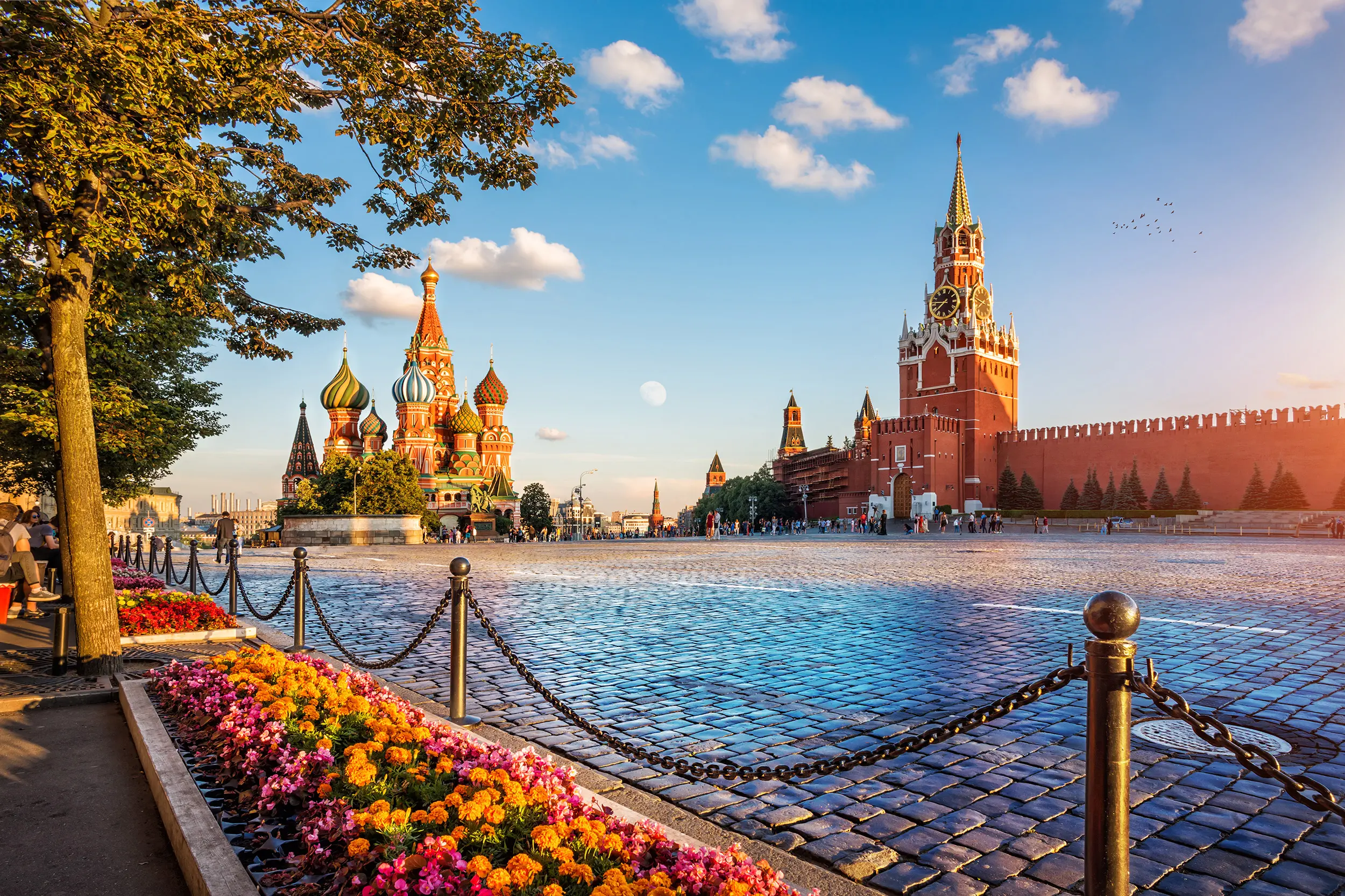
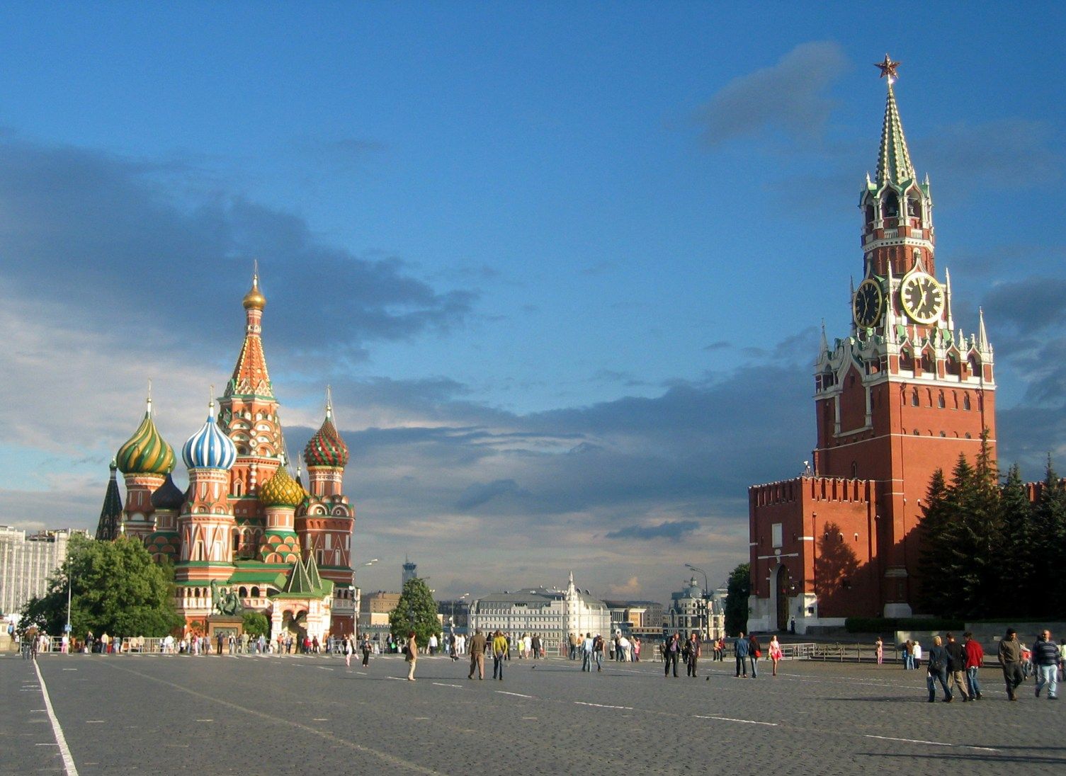
莫斯科(俄语:Москва,罗马化:Moskva,IPA:[mɐsˈkva] ![]() 聆听)是俄罗斯首都与最大都市、以及莫斯科州首府,为俄罗斯全国政治、经济、科学、文化及交通的中心。面积2,510平方公里,与莫斯科州和卡卢加州接壤。城区人口约1200万,是欧洲人口第二多的城市,仅次于伊斯坦布尔,占俄罗斯总人口的1/10。
聆听)是俄罗斯首都与最大都市、以及莫斯科州首府,为俄罗斯全国政治、经济、科学、文化及交通的中心。面积2,510平方公里,与莫斯科州和卡卢加州接壤。城区人口约1200万,是欧洲人口第二多的城市,仅次于伊斯坦布尔,占俄罗斯总人口的1/10。
莫斯科沿莫斯科河而建,由1147年的莫斯科大公时代开始,在沙皇俄国、苏联及今日的俄罗斯联邦时代,都一直担任著国家首都的角色。它是历史悠久的克里姆林宫所在地,并做为上述政权的总部,是俄罗斯数个被列入世界遗产的建筑群之一。
Moskau (russisch Москва́ [mɐskˈva], Moskwa) ist die Hauptstadt der Russischen Föderation und mit rund 12,4 Millionen Einwohnern (Stand 2017)[1] die zweitgrößte Stadt bzw. mit 15,1 Millionen (2012)[2] die größte Agglomeration Europas.
Moskau ist das politische, wirtschaftliche, wissenschaftliche und kulturelle Zentrum Russlands, mit Universitäten und Instituten sowie zahlreichen Kirchen, Theatern, Museen und Galerien. Im Stadtgebiet befinden sich einige der höchsten europäischen Hochhäuser und die markanten Sieben Schwestern, sowie der 540 Meter hohe Ostankino-Turm, das höchste Bauwerk Europas. Moskau ist Sitz der Russisch-Orthodoxen Kirche, der Patriarch residiert im Danilow-Kloster, das größte russisch-orthodoxe Kirchengebäude ist die Moskauer Christ-Erlöser-Kathedrale. Es gibt im Stadtgebiet von Moskau über 300 Kirchen.[3]
Der Kreml und der Rote Platz im Zentrum Moskaus stehen seit 1990 auf der UNESCO-Liste des Weltkulturerbes. Mit acht Fernbahnhöfen, drei internationalen Flughäfen und drei Binnenhäfen ist die Stadt wichtigster Verkehrsknoten und größte Industriestadt Russlands.
モスクワ(ロシア語:Москва́ IPA: [mɐˈskva] マスクヴァー、 発音[ヘルプ/ファイル])は、ロシア連邦の首都。連邦市として市単独でロシア連邦を構成する83の連邦構成主体のひとつとなっており、周囲を占めるモスクワ州の州都でもある。ただし州とは区別され「モスクワ市」(Город Москва)となる。人口は約1250万人でヨーロッパで最も人口の多い都市であり、世界有数の世界都市である。漢字による当て字は莫斯科。英語で発音した場合には、モスコーあるいはモスカウ(Moscow [ˈmɒskoʊ, ˈmɒskaʊ])のようになる。
Moscow (/ˈmɒskoʊ, -kaʊ/; Russian: Москва́, tr. Moskvá, IPA: [mɐˈskva] ( listen)) is the capital and most populous city of Russia, with 13.2 million residents within the city limits[11] and 17.1 million within the urban area.[12] Moscow is one of Russia's three federal cities.
Moscow is a major political, economic, cultural, and scientific centre of Russia and Eastern Europe, as well as the largest city (both by population and by area) entirely on the European continent. By broader definitions Moscow is among the world's largest cities, being the 14th largest metro area, the 18th largest agglomeration, the 14th largest urban area, and the 11th largest by population within city limits worldwide. According to Forbes 2013,[13] Moscow has been ranked as the ninth most expensive city in the world by Mercer and has one of the world's largest urban economies, being ranked as an alpha global city according to the Globalization and World Cities Research Network, and is also one of the fastest growing tourist destinations in the world according to the MasterCard Global Destination Cities Index.
Moscow is the northernmost and coldest megacity and metropolis on Earth. It is home to the Ostankino Tower, the tallest free standing structure in Europe; the Federation Tower, the tallest skyscraper in Europe; and the Moscow International Business Center. By its territorial expansion on July 1 2012 southwest into the Moscow Oblast, the area of the capital more than doubled, going from 1,091 to 2,511 square kilometers (421 to 970 sq mi), resulting in Moscow becoming the largest city on the European continent by area; it also gained an additional population of 233,000 people[14][15]
Moscow is situated on the Moskva River in the Central Federal District of European Russia, making it Europe's most populated inland city. The city is well known for its architecture, particularly its historic buildings such as Saint Basil's Cathedral with its colourful architectural style. With over 40 percent of its territory covered by greenery, it is one of the greenest capitals and major cities in Europe and the world, having the largest forest in an urban area within its borders—more than any other major city—even before its expansion in 2012. The city has served as the capital of a progression of states, from the medieval Grand Duchy of Moscow and the subsequent Tsardom of Russia to the Russian Empire to the Soviet Union and the contemporary Russian Federation.
Moscow is the seat of power of the Government of Russia, being the site of the Moscow Kremlin, a medieval city-fortress that is today the residence for work of the President of Russia. The Moscow Kremlin and Red Square are also one of several World Heritage Sites in the city. Both chambers of the Russian parliament (the State Duma and the Federation Council) also sit in the city. Moscow is considered the centre of Russian culture, having served as the home of Russian artists, scientists and sports figures and because of the presence of museums, academic and political institutions and theatres.
The city is served by a transit network, which includes four international airports,[16] nine railway terminals, numerous trams, a monorail system and one of the deepest underground rapid transit systems in the world, the Moscow Metro, the fourth-largest in the world and largest outside Asia in terms of passenger numbers, and the busiest in Europe. It is recognised as one of the city's landmarks due to the rich architecture of its 200 stations.[citation needed]
Moscow has acquired a number of epithets, most referring to its size and preeminent status within the nation: The Third Rome (Третий Рим), The Whitestone One (Белокаменная), The First Throne (Первопрестольная), The Forty Forties (Сорок Сороков) (The Forty Soroks, "sorok" translates as forty, but here it is old name of district or parish, and "forty" in old Russian means not 40, but "great many"). Moscow is one of the twelve Hero Cities. In old Russian the word "Сорок" (forty) also meant a church administrative district, which consisted of about forty churches. The demonym for a Moscow resident is "москвич" (moskvich) for male or "москвичка" (moskvichka) for female, rendered in English as Muscovite.
Moscou (en russe : Москва, Moskva, API : /mɐˈskva/) est la capitale de la Russie et compte douze millions d'habitants intra muros (2017) sur une superficie de 2 510 km2 ce qui en fait la ville la plus peuplée à la fois du pays et d'Europe. Sur le plan administratif Moscou fait partie du district fédéral central et a le statut de ville d'importance fédérale qui lui donne le même niveau d'autonomie que les autres sujets de la Russie. Elle est enclavée dans l'oblast de Moscou, mais en est administrativement indépendante. Ses habitants sont les Moscovites. Moscou se situe dans la partie européenne de la Russie au milieu d'une région de plaine. Sa latitude élevée lui vaut un climat froid et continental. Le Kremlin, son cœur historique, est édifié sur une colline qui domine la rive gauche de la rivière Moskova.
Moscou a joué un rôle central dans l'histoire de la Russie. Petit point d'appui militaire créé vers 1150 dans le nord de la Rus' de Kiev, elle prend progressivement le relais de Kiev, après la décomposition politique de cet État et les invasions mongoles du XIIIe siècle. Elle devient la capitale du Grand-duché de Moscou puis de l'Empire russe qui étend progressivement son territoire jusqu'à la frontière avec la Pologne à l'ouest, la Crimée au sud et l'océan Pacifique à l'est. Elle perd son rôle de capitale au profit de Saint-Pétersbourg lorsque Pierre le Grand au début du XVIIIe siècle décide de moderniser son pays à marche forcée. Néanmoins, au cours des XVIIIe et XIXe siècles, Moscou devient un centre industriel majeur et le cœur du réseau de communications ferré et routier d'un pays qui compte désormais parmi les grandes puissances européennes. La Révolution d'Octobre en 1917 redonne le rôle de capitale à Moscou et met en place un régime communiste qui accélère en deux décennies l'industrialisation de la ville et quadruple la population qui passe de un à quatre millions habitants. Ayant échappé de peu à l'occupation allemande durant la Seconde Guerre mondiale, la ville renoue avec une croissance économique et démographique effrénée à l'issue de celle-ci. Elle devient la capitale d'une des deux superpuissances mondiales. L'effondrement du régime communiste en 1991 entraine une profonde transformation de la ville qui abandonne presque complètement son rôle de centre industriel au profit d'une position de pôle tertiaire complètement converti à l'économie de marché. La construction du Centre de commerce international de Moscou est le symbole de cette transformation.
Moscou concentre une part particulièrement importante de la richesse économique du pays : elle produit 25 % du PIB de la Russie. La ville est le siège de nombreuses institutions universitaires et culturelles du pays. Mais cette mutation ne s'est pas faite sans poser de problèmes. Les écarts socio-économiques étant devenus considérables : une part de la population s'est fortement enrichie, tandis que l'augmentation du coût de la vie a aggravé les conditions de vie des plus modestes. Moscou a du mal à adapter ses structures routières à l'explosion du parc des véhicules des particuliers et à une croissance démographique qui se poursuit dans un contexte national pourtant déprimé sur ce plan.
Moscou dispose d'un important patrimoine artistique et architectural dont trois ensembles inscrits au Patrimoine mondial de l'Unesco. Ce sont notamment le Kremlin avec ses palais et églises, la cathédrale Saint-Basile-le-Bienheureux sur la place Rouge, la Galerie Tretiakov, le couvent de Novodievitchi, l'église de Kolomenskoïe ainsi que les sept gratte-ciel staliniens.
Moscú (en ruso, Москва, /mɐˈskva/ (?·i) transliterado como Moskvá) es la capital y la entidad federal más poblada de Rusia. La ciudad es un importante centro político, económico, cultural y científico de Rusia y del continente. Moscú es la megaciudad más septentrional de la Tierra, la segunda ciudad de Europa en población después de Estambul,345 y la sexta del mundo. Su población es de 12 108 2576 habitantes. En virtud de su expansión territorial al suroeste del óblast de Moscú, el 1 de julio de 2012 la capital aumentó su área en 2,5 veces, desde unos 1000 km² hasta 2500 km², y ganó una población adicional de 230 000 habitantes.7
Moscú está situada a orillas del río Moscova, en el Distrito Federal Central de la Rusia europea. En el curso de su historia, la ciudad ha sido capital de una sucesión de estados, desde el Gran Ducado de Moscú de la Edad Media, el Zarato ruso y la Unión Soviética, exceptuando el período del Imperio ruso. En Moscú se encuentra el Kremlin de Moscú, una antigua fortaleza donde se halla hoy el lugar de trabajo del presidente de Rusia. El Kremlin también es uno de los varios sitios que son Patrimonio de la Humanidad en la ciudad.8 Ambas cámaras del Parlamento ruso (la Duma Estatal y el Consejo de la Federación) también tienen su sede en Moscú.
La ciudad posee una amplia red de transporte que incluye tres aeropuertos internacionales, nueve estaciones de ferrocarril y uno de los más profundos sistemas de metro del mundo, el metro de Moscú, solo superado por el de Tokio en número de pasajeros. Su suburbano es reconocido como uno de los más ricos y variados arquitectónicamente en sus 215 estaciones, repartidas por la ciudad. Según la publicación Forbes 2011, Moscú es la segunda ciudad del mundo en número de multimillonarios.
Москва́ (произношение (инф.)) — столица России, город федерального значения, административный центр Центрального федерального округа и центр Московской области, в состав которой не входит. Крупнейший по численности населения город России и её субъект — 12 630 289[2] чел. (2019), самый населённый из городов, полностью расположенных в Европе, входит в десятку городов мира по численности населения[5], крупнейший русскоязычный город в мире. Центр Московской городской агломерации.
Историческая столица Великого княжества Московского, Русского царства, Российской империи (в 1728—1730 годах), Советской России и СССР. Город-герой. В Москве находятся федеральные органы государственной власти Российской Федерации (за исключением Конституционного суда), посольства иностранных государств, штаб-квартиры большинства крупнейших российских коммерческих организаций и общественных объединений.
Расположена на реке Москве в центре Восточно-Европейской равнины, в междуречье Оки и Волги. Как субъект федерации Москва граничит с Московской и Калужской областями.
Москва — популярный туристический центр России. Кремль, Красная площадь, Новодевичий монастырь и Церковь Вознесения в Коломенском входят в список объектов всемирного наследия ЮНЕСКО[6]. Она является важнейшим транспортным узлом: город обслуживают 6 аэропортов, 9 железнодорожных вокзалов, 3 речных порта (имеется речное сообщение с морями бассейнов Атлантического и Северного Ледовитого океанов). С 1935 года в Москве работает метрополитен. Москва — спортивный центр страны. В 1980 году в Москве прошли XXII летние Олимпийские игры, а в 2018 город стал одним из хозяев чемпионата мира по футболу.