
Deutsch-Chinesische Enzyklopädie, 德汉百科
 历史
历史

 文化遗产
文化遗产
 建筑艺术
建筑艺术
 图林根州
图林根州
 假期和旅游
假期和旅游


Erstmals genannt wurde die Wartburg 1080 in Brunos Abhandlung zum Sachsenkrieg „De bello Saxonico“.
Der in wesentlichen Teilen erhaltene, von den Landgrafen von Thüringen, den Ludowingern, in der zweiten Hälfte des 12. Jahrhunderts erbaute Palas ist der erste seines Bautyps überhaupt im deutschsprachigen Raum und kann als künstlerisch und architektonisch bedeutendster Bau seiner Art gelten. Das heutige Gesamterscheinungsbild der Burganlage mit Neuer Kemenate und Hauptturm sowie des sie umgebenden Landschaftsparks geht auf den Großherzog Carl Alexander von Sachsen-Weimar-Eisenach zurück.
Die Wartburg wurde 1999 unter anderem als Zeugnis des Feudalismus in Mitteleuropa und als Schaffensort Martin Luthers in die UNESCO-Welterbeliste aufgenommen.
瓦尔特堡(德语:Wartburg)是德国图林根州艾森纳赫市的城堡,位于图林根森林的西北端,海拔411米,为罗曼式建筑。由路德因·德·史宾格(Ludwig der Springer)于1073年起建,1999年列为世界文化遗产[1]。

 艺术
艺术

 国际城市
1994年世界杯足球赛
2025国际足联世界俱乐部杯
国际城市
1994年世界杯足球赛
2025国际足联世界俱乐部杯
 财政金融
财政金融
 ***全球金融中心
2003年女子世界杯足球
历史
公元 2000 - 2100
历史
公元 1500 - 2000
美国
***全球金融中心
2003年女子世界杯足球
历史
公元 2000 - 2100
历史
公元 1500 - 2000
美国
 华盛顿哥伦比亚特区


华盛顿哥伦比亚特区(英语:Washington, D.C.),是美国的首都,原称哥伦比亚特区[注 1](District of Columbia,缩写为 D.C.),以及简称华盛顿(Washington)、特区(the District)等。中文通常简称华府。华盛顿哥伦比亚特区是大多数美国联邦政府机关、与各国驻美大使馆的所在地,也是世界银行、国际货币基金、美洲国家组织等国际组织总部的所在地,并拥有为数众多的博物馆与文化史迹。哥伦比亚特区是美国最富裕、财富高度集中的地区;该地区2015年的人均生产总值为181,185美元,冠绝全美。
1776年美国独立时的首都是费城,之后因独立战争和国家新立而屡有变迁,到1785年开始纽约被定为美国的首都。1790年7月1日,国会通过《首都选址法》,决定将首都从纽约迁至波多马克河和安那考斯迪亚河汇合处附近;但完成正式迁都前先由费城暂代首都。1800年,美国联邦政府部门从临时首都的费城迁往建设完成的华盛顿,华盛顿开始作为美国首都正式运作至今[3]。华盛顿哥伦比亚特区实际上是由美国国会直接管辖的联邦地区,因此不属于美国的任何州份。
华盛顿哥伦比亚特区位于美国东岸的中大西洋地区,属马里兰州和弗吉尼亚州的交界处,两州界河波多马克河由西北向东南流贯特区,形成特区西面的天然界限。成立之初,哥伦比亚特区是一个边长10英里(16千米)的长方形区域,不仅包括了特区现在的全部范围,还包括波多马克河西岸弗吉尼亚州亚历山德里亚县,即今日的阿灵顿县以及亚历山德里亚市。特区成立后不久,西岸的居民就因为国会过度重视东岸以及蓄奴等问题,发起了回归弗吉尼亚的运动,经他们多次请愿,美国国会于1846年7月9日通过法案,并经弗吉尼亚人民大会批准,将波多马克河南岸的土地交还南方的弗吉尼亚州。特区设立早期,波多马克河北岸有乔治城镇、华盛顿市及华盛顿县三个分开的行政区划;其中建立于1791年的华盛顿市乃为彰显乔治·华盛顿对美国建国的贡献而命名,后来发展为特区中的核心城市。依据一项1871年的立法,前述三区于1878年合并为华盛顿市,而联邦管辖的特区及华盛顿市地方政府从此辖区重叠,因此产生今日使用的“华盛顿哥伦比亚特区”合称。
Der District of Columbia oder Washington, D.C. [ˈwɔʃɪŋtn̩] ist Bundesdistrikt, Regierungssitz und seit 1800 die Hauptstadt der Vereinigten Staaten. Der Distrikt ist kein Bundesstaat und gehört auch zu keinem, er ist vielmehr dem Kongress der Vereinigten Staaten direkt unterstellt. Trotz Namensgleichheit mit dem Bundesstaat Washington wird Washington, D.C. im deutschen Sprachraum meist nur „Washington“ genannt. D.C. steht dabei für District of Columbia.
Bei der Volkszählung 2010 hatte Washington, D.C. 601.723 Einwohner.[1] Das United States Census Bureau schätzte die Einwohnerzahl zum 1. Juli 2015 auf 672.228 Einwohner, nach einem stetigen Abfall der Bevölkerung seit 1950 der erste größere Zuwachs.[2] Der Großraum Washington[3] hatte 5.582.170 Einwohner. Zusammen mit dem benachbarten Großraum Baltimore hatte die Region laut Zensus insgesamt 8.572.971 Einwohner.[4]
Mit dem Weißen Haus als Amts- und Wohnsitz des Präsidenten und dem Kapitol, das den Kongress (bestehend aus Senat und Repräsentantenhaus) beherbergt, sowie dem Obersten Gerichtshof befinden sich die Spitzen aller drei verfassungsmäßigen Gewalten in der Stadt. Washington ist darüber hinaus Sitz des Internationalen Währungsfonds, der Weltbank und der Organisation Amerikanischer Staaten.
ワシントンD.C.(ワシントン・ディーシー、英: Washington, D.C.)は
同国東海岸、メリーランド州とヴァージニア州に挟まれたポトマック川河畔に位置する。
現代の主要都市としては狭隘で人口もさほど多くないが、超大国の政府所在地として国際的に強大な政治的影響力を保持する世界都市であり、また金融センターとしても高い重要性を持つ。首都としての機能を果たすべく設計された、計画都市である[† 1]。
Washington, D.C., formally the District of Columbia and commonly referred to as Washington or D.C., is the capital of the United States of America.[4] Founded after the American Revolution as the seat of government of the newly independent country, Washington was named after George Washington, first President of the United States and Founding Father.[5] Washington is the principal city of the Washington metropolitan area, which has a population of 6,131,977.[6] As the seat of the United States federal government and several international organizations, the city is an important world political capital.[7] Washington is one of the most visited cities in the world, with more than 20 million annual tourists.[8][9]
The signing of the Residence Act on July 16, 1790, approved the creation of a capital district located along the Potomac River on the country's East Coast. The U.S. Constitution provided for a federal district under the exclusive jurisdiction of the Congress and the District is therefore not a part of any state. The states of Maryland and Virginia each donated land to form the federal district, which included the pre-existing settlements of Georgetown and Alexandria. Named in honor of President George Washington, the City of Washington was founded in 1791 to serve as the new national capital. In 1846, Congress returned the land originally ceded by Virginia; in 1871, it created a single municipal government for the remaining portion of the District.
Washington had an estimated population of 693,972 as of July 2017, making it the 20th largest American city by population. Commuters from the surrounding Maryland and Virginia suburbs raise the city's daytime population to more than one million during the workweek. The Washington metropolitan area, of which the District is the principal city, has a population of over 6 million, the sixth-largest metropolitan statistical area in the country.
All three branches of the U.S. federal government are centered in the District: U.S. Congress (legislative), President (executive), and the U.S. Supreme Court (judicial). Washington is home to many national monuments and museums, which are primarily situated on or around the National Mall. The city hosts 177 foreign embassies as well as the headquarters of many international organizations, trade unions, non-profit, lobbying groups, and professional associations, including the Organization of American States, AARP, the National Geographic Society, the Human Rights Campaign, the International Finance Corporation, and the American Red Cross.
A locally elected mayor and a 13‑member council have governed the District since 1973. However, Congress maintains supreme authority over the city and may overturn local laws. D.C. residents elect a non-voting, at-large congressional delegate to the House of Representatives, but the District has no representation in the Senate. The District receives three electoral votes in presidential elections as permitted by the Twenty-third Amendment to the United States Constitution, ratified in 1961.
Washington, dans le district de Columbia (en anglais : Washington, District of Columbia), souvent appelée Washington, D.C., The District, ou simplement D.C. (pour éviter la confusion avec l'État de Washington), est une ville indépendante américaine, capitale des États-Unis. Selon les dernières estimations (2013), elle compte 646 449 habitants intra-muros sur une superficie de 177 km2 ; son aire urbaine en compte environ 5,8 millions, la septième des États-Unis.
En tant que capitale fédérale, elle ne fait pas partie des cinquante États de l'Union et dépend directement du gouvernement fédéral. À ce titre, la ville est le siège de nombreuses institutions américaines, telles que la Maison-Blanche, résidence officielle du président ; le Capitole, siège du Congrès (constitué de ses deux chambres : celle des représentants et le Sénat), ainsi que le siège de la Banque mondiale (BM), de la Cour suprême et d'autres organismes fédéraux, comme la Réserve fédérale des États-Unis (Fed). Elle accueille en outre 176 ambassades et représentations diplomatiques.
Washington est créée à la suite de la signature du Residence Act en 1790, qui prévoit la création d'une capitale fédérale. Elle est fondée en janvier 1791, sur les rives du fleuve Potomac, à proximité des villes de Georgetown et d'Alexandria. Nommée en hommage au premier président des États-Unis, George Washington, elle est construite ex nihilo selon un plan hippodamien de l'ingénieur franco-américain Pierre Charles L'Enfant. L'urbanisme diffère de la plupart des autres villes américaines car la construction de gratte-ciel y est interdite : l'architecture de Washington est marquée par une faible hauteur et un héritage de l'architecture coloniale. Peu peuplée durant la première moitié du XIXe siècle, ce n'est qu'à la fin de la guerre de Sécession qu'elle acquiert sa légitimité en tant que capitale, devenant le symbole de l'unité retrouvée.
Située sur la côte atlantique du nord-est du pays, entre le Maryland et la Virginie, la ville se trouve à soixante kilomètres au sud de Baltimore, à deux cents kilomètres de Philadelphie et trois cents kilomètres de New York. Elle marque l'extrémité méridionale de la mégalopole américaine, appelée également BosWash. Les coordonnées géographiques de la ville correspondent au point zéro, d'où sont calculées toutes les distances routières aux États-Unis. Son climat est de type subtropical humide, avec de fortes variations de température entre l'été et l'hiver.
En tant que siège de la plupart des institutions fédérales, l'économie est fortement dépendante des activités gouvernementales, qui représentent jusqu'à 50 % de son PIB au milieu du XXe siècle. Aujourd'hui, l'économie est diversifiée, notamment dans l'industrie de l'armement et de l'informatique.
La population de la ville se stabilise de nos jours autour de 600 000 habitants, après avoir connu une baisse importante depuis la Seconde Guerre mondiale, essentiellement en raison du départ des Blancs pour les banlieues environnantes. Devenue une ville en majorité composée d'Afro-Américains (50,1 %), Washington comprend historiquement plusieurs ghettos — dont certains connaissent actuellement un processus de gentrification — et est depuis sa fondation un bastion du Parti démocrate.
La ville compte plusieurs universités, dont la prestigieuse université de Georgetown, ainsi que la Bibliothèque du Congrès, plus grande bibliothèque au monde.
Washington dispose de services de polices dépendant de la municipalité ; ainsi que la Garde nationale du district de Columbia (en) qui en tant que force fédérale dépend du président lui-même. Le district de Columbia ne dispose donc pas de forces autonomes comme les Polices d'État ou les Forces de défense d'État existant dans les États de l'Union.
Washington D.C. (AFI: /ˈwɔʃʃinton/[2]; in inglese [ˈwɒʃɪŋtən]) è la capitale degli Stati Uniti d'America, con una popolazione di 672 228 abitanti[1] (5 582 170 abitanti nell'area metropolitana)[3]. Si trova sulla costa orientale degli Stati Uniti a circa 50 km dal mare, a sud dello stato del Maryland, a nord dello stato della Virginia e a 374 km circa a sud di New York.
La città di Washington coincide territorialmente e politicamente con il Distretto di Columbia[4] (in inglese: District of Columbia, in sigla D.C., distretto federale previsto dalla Costituzione dell'Unione e formalizzato dal District of Columbia Organic Act del 1801), di cui è parte integrante. Infatti, mentre in origine il distretto comprendeva le contee di Washington (donata dallo stato del Maryland) ed Alexandria (donata dallo stato della Virginia), in seguito ad un referendum del 1846 quest'ultima è tornata allo stato della Virginia e ha cambiato nome in Contea di Arlington.
Di conseguenza con il District of Columbia Organic Act del 1871,[5] il Congresso ha ufficialmente soppresso la contea di Washington, che comprendeva l'attuale città di Washington, sottoponendo l'intero territorio dapprima ad un unico governatore di nomina presidenziale, poi, dal 1845, ad un triumvirato composto da due politici e un ingegnere. Da quel momento la Città di Washington e il Distretto di Columbia divennero la stessa entità, condidivendo la personalità giuridica.[6]
Ciononostante, l'area metropolitana di Washington deborda dai confini del distretto, estendendosi anche su 7 contee del Maryland (Anne Arundel, Calvert, Charles, Frederick, Howard, Montgomery e Prince George's), su 5 contee della Virginia (Arlington, ossia l'ex Contea di Alexandria, Fairfax, Loudon, Prince William e Stafford) e su 5 città autonome dello stesso Stato (Alexandria, Fairfax, Falls Church, Manassas e Manassas Park). Gran parte dell'area è collegata da un servizio di metropolitana.
Nel 1973 le richieste per una maggiore democrazia nel distretto portarono all'approvazione del District of Columbia Home Rule Act,[7] la legge che soppresse il triumvirato e affidò l'amministrazione cittadina a un sindaco eletto dal popolo, il Mayor, e a un Consiglio comunale, il Council of the District. Il distretto, che gode di 3 voti nel collegio dei Grandi elettori del Presidente dell'Unione, non prevede nella propria legislazione la pena di morte.
Hanno sede a Washington le principali istituzioni di governo degli Stati Uniti (Presidente, Congresso, Corte Suprema), molti ministeri ed enti federali, e alcune organizzazioni internazionali, tra cui la Banca Mondiale, il Fondo Monetario Internazionale e l'Organizzazione degli Stati Americani.
Washington D. C. (/ˈwɑʃɪŋtən diˈsi/ en inglés), oficialmente denominado Distrito de Columbia (District of Columbia), es la capital de los Estados Unidos de América. Se administra como distrito federal, una entidad diferente a los cincuenta estados que componen dicha nación, y depende directamente del gobierno federal. El Distrito de Columbia fue fundado el 16 de julio de 1790, y en 1791 se oficializó, dentro del distrito, una nueva ciudad denominada Washington, al este de la ya existente Georgetown. En 1871 se unificaron los gobiernos de estas dos ciudades y del resto de poblaciones del distrito en una sola entidad, D. C.
Se localiza a orillas del río Potomac y está rodeada por los estados de Virginia al oeste, y de Maryland al norte, este y sur.
La ciudad de Washington nació como una ciudad planificada, y fue desarrollada a finales del siglo XVIII para servir como la capital nacional permanente, después de que diversas localidades ostentaran dicha posición desde la independencia del país, en 1776; en tanto, el distrito federal fue formado para marcar la diferencia entre la capital nacional y los estados. La ciudad fue nombrada en honor a George Washington, el primer presidente de los Estados Unidos. El nombre del distrito, Columbia, es el nombre poético de Estados Unidos, en referencia a Cristóbal Colón (en inglés Christopher Columbus), primer explorador en llegar a América. La ciudad es llamada comúnmente Washington, the District (el Distrito) o simplemente D. C. En el siglo XIX también se la conoció como Ciudad Federal o Ciudad de Washington.
Los centros de las tres ramas del Gobierno de los Estados Unidos se ubican en el Distrito. También situadas en la ciudad están las sedes del Banco Mundial, el FMI, la OEA, el BID, y otras instituciones nacionales e internacionales, incluyendo asociaciones profesionales y sindicatos. Debido a su importancia a nivel político, Washington es un lugar de frecuentes manifestaciones y protestas, particularmente en el National Mall. Además es un destino popular entre los turistas, debido a los numerosos monumentos y lugares de interés nacional. La ciudad es un centro de la historia y cultura estadounidense, y en ella se encuentra el complejo de museos más grande del mundo (el Instituto Smithsoniano), además de galerías de arte, universidades, catedrales, centros e instituciones de arte dramático, y escenarios de música nativa.
El Distrito de Columbia y la ciudad de Washington son gobernados por un solo gobierno municipal. Para cuestiones prácticas son considerados como la misma entidad. Éste no siempre ha sido el caso: hasta 1871 —cuando Georgetown dejó de ser una ciudad separada— había múltiples jurisdicciones dentro del Distrito.3 A pesar de que hay un gobierno municipal y un alcalde, el Congreso tiene la autoridad suprema sobre la ciudad y el distrito, lo que resulta en que los ciudadanos tengan menos autogobierno que los residentes de los estados. El Distrito tiene un delegado en el Congreso, que participa en los debates pero no tiene derecho a voto.
La población del Distrito de Columbia es de 646 449 habitantes en 2013 según estimaciones de la Oficina del Censo de los Estados Unidos.1 El área metropolitana de Washington D. C. es la octava más grande de Estados Unidos, con más de 5 millones de residentes,2 y el área metropolitana que forma junto a la cercana Baltimore tiene una población que excede los 8 millones. Si Washington D. C. fuera un estado, estaría último en cuanto a superficie (por detrás de Rhode Island), en penúltimo lugar en cuanto a población (por delante de Wyoming), en el lugar n.º 35 en cuanto a producto interno bruto y primero en densidad de población.
Aunque el Distrito de Columbia no tiene un miembro votante del Congreso los residentes todavía están obligados a pagar impuestos al gobierno federal. Esto es diferente de los territorios de Estados Unidos, como Puerto Rico, cuyos ciudadanos en general no pagan impuestos sobre la renta individual. Los residentes protestan por la falta de derechos de voto, sobre todo porque la falta de representación en el Parlamento británico fue una de las principales razones para la independencia del país del Reino Unido. La ciudad adoptó una frase de la Guerra de la Independencia, «No hay tributación sin representación», para protestar por la falta de derechos de voto.4 El eslogan también aparece en las placas de automóvil expedidas por la ciudad.5

 汽车
汽车
 能源
能源

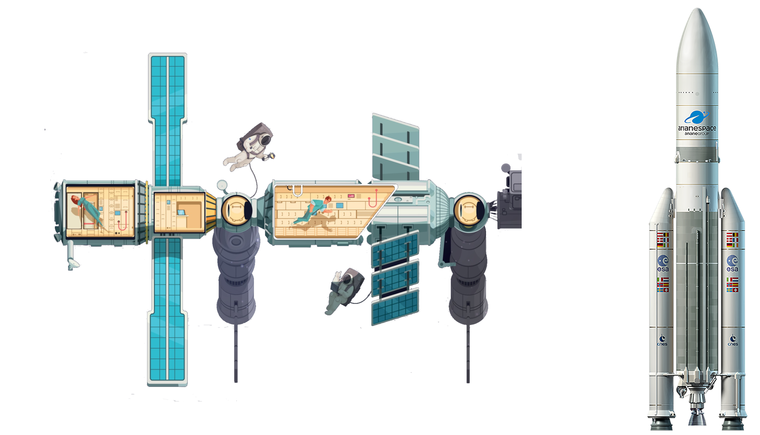 航空航天
航空航天
 运输和交通
运输和交通
 科学技术
科学技术

瓦普寺(老挝语:ຜາສາດຫີນວັດພູ),是一座位于老挝南部占巴塞省地区的印度教寺院。此寺建于公元5世纪柬埔寨扶南时代,供奉湿婆神的象征林伽,但在13世纪吴哥王朝接受上座部佛教后被改成佛教寺院一直保留至现在。瓦普寺在2001年成为世界遗产。
Wat Phu (Lao: ວັດພູ, „Bergtempel“) ist ein ehemaliger Tempelkomplex der Khmer in der Provinz Champasak im Süden von Laos. Die erhaltenen Ruinen stammen aus dem 11. bis 13. Jahrhundert. Der „Tempelbezirk Wat Phou und die zugehörigen altertümlichen Siedlungen in der Kulturlandschaft Champasak“ sind seit 2001 UNESCO-Weltkulturerbe.

瓦特·泰勒农民起义(英语:Peasants' Revolt,直译为“农民反抗”),又称瓦特·泰勒叛乱(Wat Tyler's Rebellion)或大起义(Great Rising),是1381年发生的、英格兰历史上最大规模的民众暴动,也是欧洲中世纪后期民变浪潮的一个组成。虽然这次起义以失败告终,但被后世视为中世纪英格兰农奴制开始走向终结的标志,并使英格兰上层统治阶级更加认识到下层民众的苦难和对现行封建制度进行改革的迫切性。起义的一些领导者,如约翰·鲍尔、瓦特·泰勒、杰克斯·特劳在大众文化中广为人知。
Der Bauernaufstand von 1381 war der größte Bauernaufstand im mittelalterlichen England.
Die Ursachen für den Aufstand lagen in verschiedenen sozialen Umwälzungen und Krisen im England der damaligen Zeit. Seit der normannischen Eroberung Englands im Jahre 1066 bildete die örtliche Grundherrschaft (manor) das Grundelement der sozialen Ordnung auf dem Land, insbesondere im Süden und in den Midlands. Die Bauern waren den örtlichen Lords und Landbesitzern dienst- und abgabenpflichtig. Insgesamt waren die Dorfgemeinschaften weitgehend selbstgenügsam und die einzigen nicht lokal erzeugten Güter, die auf den Märkten gehandelt wurden, waren Salz, Eisen und einige Verbrauchswaren. Im 14. Jahrhundert kam es zu einem zunehmenden Eindringen der Geldwirtschaft in die dörfliche Welt und damit zu einer Auflockerung der sozialen Ordnung. Ursächlich hierfür war die zunehmenden Bedeutung des überregionalen Handels und der überregionalen Märkte. Diese Geldwirtschaft wirkte sich anfänglich überwiegend zum Vorteil der Landbesitzer aus. Erst als es zu einem Arbeitskräftemangel infolge der großen Pestwelle von 1348/49 kam, stiegen die Löhne. Die Gutsherren versuchten, dem Arbeitskräftemangel mit erhöhten Arbeitsverpflichtungen und Abgaben beizukommen. Dies führte zur Arbeitsverweigerung und Flucht von Bauern zu anderen Grundherren. Verschärfte Strafen hatten wenig Effekt und die Bauern beriefen sich auf die Bestimmungen des Doomesday Books, zum Beweis, dass ihre Vorväter frei gewesen seien. Um der sich anbahnenden sozialen Unordnung zu begegnen, wurde ab 1349 eine Arbeitsgesetzgebung erlassen. 1351 trat das Statute of Labourers in Kraft und später folgten weitere Verordnungen. Diese Gesetze hatten die Stabilisierung der alten Ordnung zum Ziel und kamen vor allem den Besitzenden zugute. Sie bekämpften den Anstieg der Löhne und das Absinken der Abgaben. Preise und Löhne wurden festgesetzt, Almosen an Arbeitsfähige verboten und die Mobilität von Wanderarbeitern eingeschränkt.[1] Zur Steigerung der allgemeinen Unzufriedenheit in der bäuerlichen Bevölkerung trugen die Predigten von John Ball, des „tollen Predigers von Kent“, bei, der das Menschenrecht und die Gleichheit aller verkündete und unter den Bauern begeisterte Zuhörer fand.
Durch den langjährigen Krieg mit Frankreich war die englische Krone in ständiger Geldnot. 1381 wurde eine Kopfsteuer (poll tax) eingeführt, die jedem männlichen Erwachsenen die Zahlung von einem Schilling auferlegte. Diese Abgabe betraf auch die Bevölkerungsschichten, die bisher von allgemeinen Abgaben befreit geblieben waren, und bildete den unmittelbaren äußeren Auslöser für den Aufstand.[2] Die Kopfsteuer wurde im Parlament von John of Gaunt, dem 1. Duke of Lancaster, veranlasst, weshalb die Aufständischen ihm die Hauptschuld gaben.
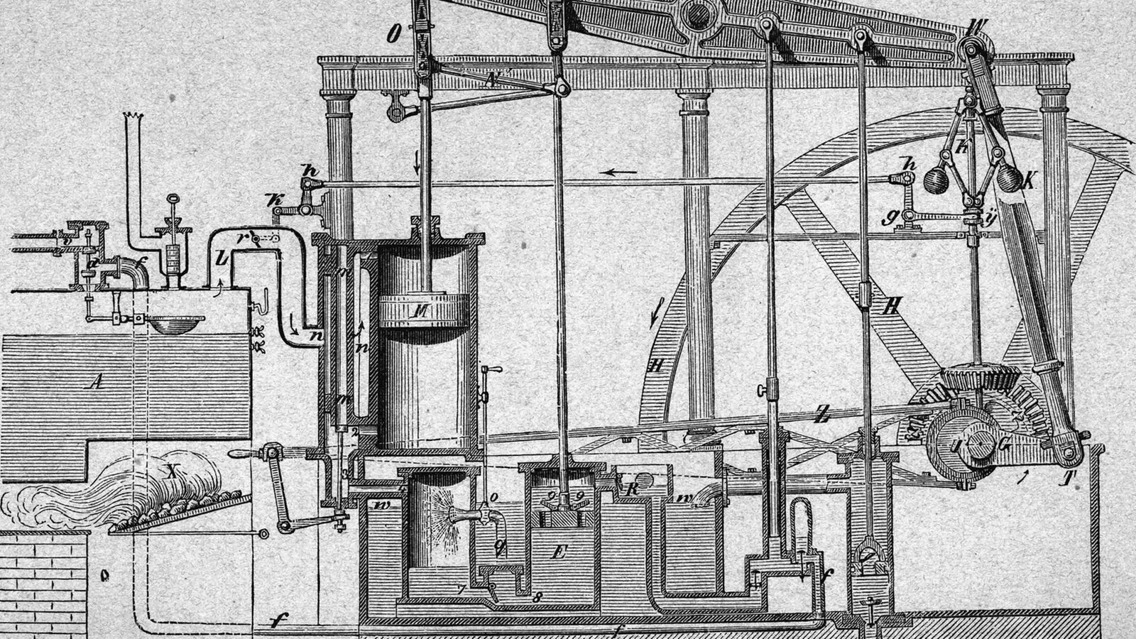
瓦特蒸汽机(Watt steam engine),又称博尔顿-瓦特蒸汽机(Boulton and Watt steam engine),是一种由詹姆斯·瓦特设计的早期蒸汽机,是工业革命的推动力之一。詹姆斯·瓦特在1763年至1775年期间,在马修·博尔顿的支持下,零星地展开设计。
与早期其他人设计的蒸汽机(如纽可门蒸汽机)相比,瓦特设计的蒸汽机节省了更多的燃料。1776年,瓦特设计的蒸汽机开始商业化,此后瓦特持续改进自己设计的蒸汽机。
过了很多年后,新的设计才开始逐步取代瓦特设计的蒸汽机[1]。
The Watt steam engine design became synonymous with steam engines, and it was many years before significantly new designs began to replace the basic Watt design.
The first steam engines, introduced by Thomas Newcomen in 1712, were of the "atmospheric" design. At the end of the power stroke, the weight of the object being moved by the engine pulled the piston to the top of the cylinder as steam was introduced. Then the cylinder was cooled by a spray of water, which caused the steam to condense, forming a partial vacuum in the cylinder. Atmospheric pressure on the top of the piston pushed it down, lifting the work object. James Watt noticed that it required significant amounts of heat to warm the cylinder back up to the point where steam could enter the cylinder without immediately condensing. When the cylinder was warm enough that it became filled with steam the next power stroke could commence.
Watt realised that the heat needed to warm the cylinder could be saved by adding a separate condensing cylinder. After the power cylinder was filled with steam, a valve was opened to the secondary cylinder, allowing the steam to flow into it and be condensed, which drew the steam from the main cylinder causing the power stroke. The condensing cylinder was water cooled to keep the steam condensing. At the end of the power stroke, the valve was closed so the power cylinder could be filled with steam as the piston moved to the top. The result was the same cycle as Newcomen's design, but without any cooling of the power cylinder which was immediately ready for another stroke.
Watt worked on the design over a period of several years, introducing the condenser, and introducing improvements to practically every part of the design. Notably, Watt performed a lengthy series of trials on ways to seal the piston in the cylinder, which considerably reduced leakage during the power stroke, preventing power loss. All of these changes produced a more reliable design which used half as much coal to produce the same amount of power.[1]
The new design was introduced commercially in 1776, with the first example sold to the Carron Company ironworks. Watt continued working to improve the engine, and in 1781 introduced a system using a sun and planet gear to turn the linear motion of the engines into rotary motion. This made it useful not only in the original pumping role, but also as a direct replacement in roles where a water wheel would have been used previously. This was a key moment in the industrial revolution, since power sources could now be located anywhere instead of, as previously, needing a suitable water source and topography. Watt's partner Matthew Boulton began developing a multitude of machines that made use of this rotary power, developing the first modern industrialized factory, the Soho Foundry, which in turn produced new steam engine designs. Watt's early engines were like the original Newcomen designs in that they used low-pressure steam, and all of the power was produced by atmospheric pressure. When, in the early 1800s, other companies introduced high-pressure steam engines, Watt was reluctant to follow suit due to safety concerns.[2] Wanting to improve on the performance of his engines, Watt began considering the use of higher-pressure steam, as well as designs using multiple cylinders in both the double-acting concept and the multiple-expansion concept. These double-acting engines required the invention of the parallel motion, which allowed the piston rods of the individual cylinders to move in straight lines, keeping the piston true in the cylinder, while the walking beam end moved through an arc, somewhat analogous to a crosshead in later steam engines.

Der Staat Wei (chinesisch 魏, Pinyin Wèi) existierte zur Zeit der Streitenden Reiche in China. Sein Territorium grenzte an die Staaten Qin, Qi, Zhao, Chou und Han. Es umfasste die heutigen Provinzen Hebei, Henan, Shanxi und Shandong. Nachdem König Hui die Hauptstadt von Anyi (安邑, im heutigen Kreis Xia) nach Daliang (heutiges Kaifeng) verlegt hatte, nannte man den Staat auch Liang.
Également appelé État Liang à partir de 340 av. J.-C., l'État Wei (魏国 / 魏國, 445 - 225 av. J.-C.) était un État de la Chine ancienne pendant la période des Royaumes combattants. Initialement clan de grands feudataires de l'État de Jin, le Wei fut l'un des trois États créés par la partition de celui-ci par les Trois familles en 403 av. J.-C.
Cet état ne doit pas être confondu avec son homonyme, la Cité-État de Wei, fondée antérieurement durant la période des Printemps et Automnes.
Lo Stato di Wei (cinese: 魏; pinyin: Wèi) fu uno Stato della Cina nel Periodo dei regni combattenti. Il suo territorio era situato fra gli Stati di Qin e Qi ed includeva parte delle odierne regioni di Henan, Hebei, Shanxi e Shandong. Quando la sua capitale fu trasferita da Anyi a Daliang (l'odierna Kaifeng) durante il regno di Hui di Wei, lo Stato di Wei fu anche chiamato stato di Liang.
Lo Stato raggiunse la massima potenza sotto i marchesi Wen e Wu. Il re Hui di Wei, terzo sovrano dello Stato, si concentrò sullo sviluppo economico e portò avanti progetti di irrigazione intorno al Fiume Giallo.
Lo Stato di Wei tentò l'espansione verso est, ma fu fermato in una serie di battaglie, come quella di Maling nel 341 a.C. Ad ovest, lo Stato di Qin gli sottrasse la regione di Hexi, un'area strategica sulla riva occidentale del Fiume Giallo. Lo Stato di Wei si coalizzò militarmente con lo Stato di Han, ma l'esercito Qin ebbe ragione delle forze coalizzate nella battaglia di Yique (293 a.C.).
Lo Stato di Wei si arrese ai Qin nel 225 a.C., dopo l'inondazione della capitale Daliang provocata dal generale Qin Wan Fen.
Wei (Chino: 魏; Wade-Giles: Wei4; Pinyin: Wèi) era un estado de la época de los Reinos Combatientes en China. Su territorio se encontraba entre los estados de Qin y Qi y comprendía las modernas áreas de Henan, Hebei, Shanxi y Shandong. Después de que su capital fue trasladada de Anyi a Daliang (actual Kaifeng) en 361 a. C. fue llamado también Liang(梁).
Вэй (кит. 魏, пиньинь: Wèi) — удельное княжество, а с 334 года до н. э. — царство в древнем Китае, существовавшее в период Сражающихся Царств (Чжаньго), существовавшее c 445 до н. э. по 225 до н. э. Царство Вэй располагалось между царствами Цинь и Ци, в современном Китае территория Вэй находится в провинциях Хэнань, Хэбэй, Шаньси и Шаньдун. Столицей первоначально был город Аньи 安邑 (совр.Юньчэн), а потом Хуэй-ван перенёс столицу в Далян (современный Кайфэн). После переноса столицы царство называли также Лян.
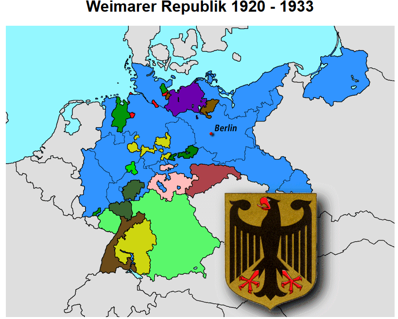
政权落入社会民主党人手中。他们中大多数人早已放弃了早年的革命观点,认为自己的主要任务是确保旧政体按部就班地向新政体过渡。工业和农业中的私有财 产依然不可侵犯;思想上多半是反对共和国的旧官员和法官全被留用;帝国的军官团保留了对军队的指挥权。左翼激进势力企图将革命继续朝社会主义方向推进,遭 到武力反对。1919年1月选举产生的、在魏玛召开的会议上通过了帝国新宪法的国民议会中拥有多数票的是社会民主党、德国民主党和中央党这3个彻底共和主 义的政党。但是,在20年代时,对民主国家或多或少持保留态度的那些力量在人民和议会中越来越强大。魏玛共和国是“没有共和党人的共和国”。敌人必欲将其 除之而后快,而拥护者却只是三心二意地在捍卫它。特别是战后的经济困境以及德国在1919年被迫签字的凡尔赛和约的苛刻条件引起了人们对共和国的重重怀 疑,其结果是国内政局愈益不稳。 1923年战后的混乱达到高潮(通货膨胀、鲁尔区被占、希特勒政变、共产党的颠覆企图);嗣后,随着经济的复苏,出现了政治上一定程度的平静。古斯塔夫· 施特雷塞曼的外交政策通过洛迦诺公约(1925)和加入国联(1926)使战败的德国重获政治上的平等权利。艺术和科学在“黄金的20年代”经历了一个短 暂而活跃的繁荣期。1925年,第一任帝国总统,社会民主党人弗里德里希·艾伯特去世后,前陆军元帅兴登堡作为右翼候选人被选为国家元首。他虽然严守宪 法,但内心里对共和制国家却从无好感。随着1929年世界经济危机的发生,魏玛共和国开始每况愈下。左翼和右翼激进主义都利用了失业和普遍的贫困。议会中 已无具有执政能力的多数;各届内阁都仰仗总统的支持。迄今为止无足轻重的阿道夫·希特勒的国家社会主义运动以貌似革命的宣传将极端反民主的倾向和疯狂的排 犹主义结合起来,从1930年起扶摇直上,并于1932年成为最强的政党。1933年1月30日希特勒成为帝国总理。在内阁中,除了他的党羽外还有几名右 翼营垒的政治家和无党派专业部长,因此,存在着阻止国家社会主义分子独裁的希望。
 美食家
美食家
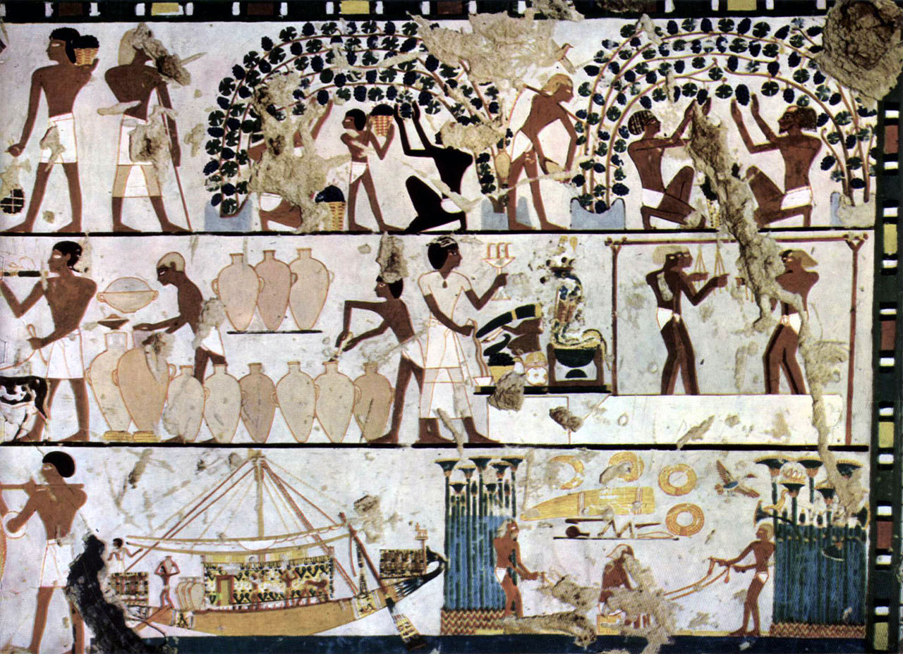
埃及的葡萄栽培传统可以追溯到几千年前。在古埃及,葡萄酒是上层阶级的饮料,它的生产受到特别关注,消费它是一种高级声望的表现。由于葡萄树不属于埃及的原始植物群,它可能是在前王朝时代从迦南引入的。
古埃及的私人葡萄园最早见于旧王国。在新王国的塞班墓中,对葡萄园和葡萄酒生产的描绘是一个流行的主题。
野生葡萄树(Vitis sylvestris)不属于埃及的植物群,其起源和首次栽培被认为是在叙利亚-巴勒斯坦地区,在公元前四千年,那里的葡萄栽培已经是食品生产的一个重要组成部分。早在王朝前时期,葡萄酒就以精制的形式从这一地区传入埃及[2]。
1988年,德国考古研究所(DAI)在阿比多斯(Umm el-Qaab)的U墓地发现了法老天蝎座一世的U-j墓,其年代为公元前3320年左右的Naqada IIIa时期,这为这些王朝前的葡萄酒进口提供了重要证据。两个墓室内仍有约200件进口器皿在原地,从其形状和材料上可以明显区别于同时代的埃及陶器。通过化学分析,这些器皿的内容被证实是葡萄酒。一些器皿中还含有无花果片,它们可能被挂在器皿中以改善口感(加糖、调味)。乌尔里希-哈通(Ulrich Hartung)认为,这位国王的陵墓配备了大约700个进口器皿,即平均容量为6至7升,大约有4500升的酒。
Der Weinbau in Ägypten hat eine jahrtausendealte Tradition. Dies wird durch die Darstellung der Weinherstellung in verschiedenen Reliefen belegt.
Der Wein war im Alten Ägypten ein Getränk der Oberschicht, dessen Produktion man besondere Beachtung schenkte und dessen Konsum Ausdruck von hohem Prestige war. Da die Weinrebe nicht zur ursprünglichen Flora Ägyptens gehörte, wurde sie in vordynastischer Zeit vermutlich aus Kanaan eingeführt.[1]
Private Weingüter sind im Alten Ägypten erstmals im Alten Reich belegt. In den thebanischen Gräbern des Neuen Reichs war die Darstellung von Weingärten und Weinproduktion ein beliebtes Motiv.
Die Herkunft und erste Kultivierung der wilden Weinrebe (Vitis sylvestris), die nicht zur Flora Ägyptens gehört, wird im syrisch-palästinischen Raum vermutet, wo der Weinbau im 4. Jahrtausend v. Chr. bereits ein wesentlicher Bestandteil der Lebensmittelproduktion war. Schon in vordynastischer Zeit wurde Wein in veredelter Form aus diesem Raum nach Ägypten eingeführt.[2]
Ein wichtiger Beleg für diese vordynastischen Weinimporte liefert das Grab U-j von Pharao Skorpion I., welches 1988 im Friedhof U in Abydos (Umm el-Qaab) vom deutschen Archäologischen Institut (DAI) entdeckt wurde und in die Naqada IIIa-Zeit um 3320 v. Chr. datiert wird. Zwei Kammern enthielten noch etwa 200 importierte Gefäße in situ, die durch ihre Formen und Material deutlich von gleichzeitiger ägyptischer Keramik zu unterscheiden sind. Als Inhalt der Gefäße ist durch chemische Untersuchungen Wein gesichert. Einige Gefäße enthielten zudem Feigenscheiben, die vermutlich zur Geschmacksverbesserung (Süßung, Aromatisierung) in die Gefäße gehängt worden sind. Ulrich Hartung vermutet, dass das Grab dieses Königs mit etwa 700 Importgefäßen, d. h. bei ihrem durchschnittlichen Fassungsvermögen von 6 bis 7 Litern mit etwa 4500 Litern Wein ausgestattet war.[