Deutsch-Chinesische Enzyklopädie, 德汉百科
 Ningxia Huizu Zizhiqu-NX
 Geography

Das Liupan-Gebirge (Liupan Shan 六盘山, auch Liupan Shanmai 六盘山脉 oder (für den südlichen Teil) Long Shan 陇山) in Süd-Ningxia und Ost-Gansu ist einer der wenigen von Norden nach Süden verlaufenden Gebirgszüge Chinas im Grenzgebiet der chinesischen Provinzen Ningxia, Gansu und Shaanxi. Es ist ca. 240 km lang und bildet die Wasserscheide zwischen den Flüssen Wei He 渭河 und Jing He 泾河. Sein Hauptgipfel ist der Migang Shan 米缸山 an der Grenze von Jingyuan 泾源 und Longde 隆德 mit 2.942 Metern.
*Yellow river
China
Gansu Sheng-GS
Henan Sheng-HA
Nei Mongol Zizhiqu-NM
Ningxia Huizu Zizhiqu-NX
Qinghai Sheng-QH
Shaanxi Sheng-SN
Shanxi Sheng-SX
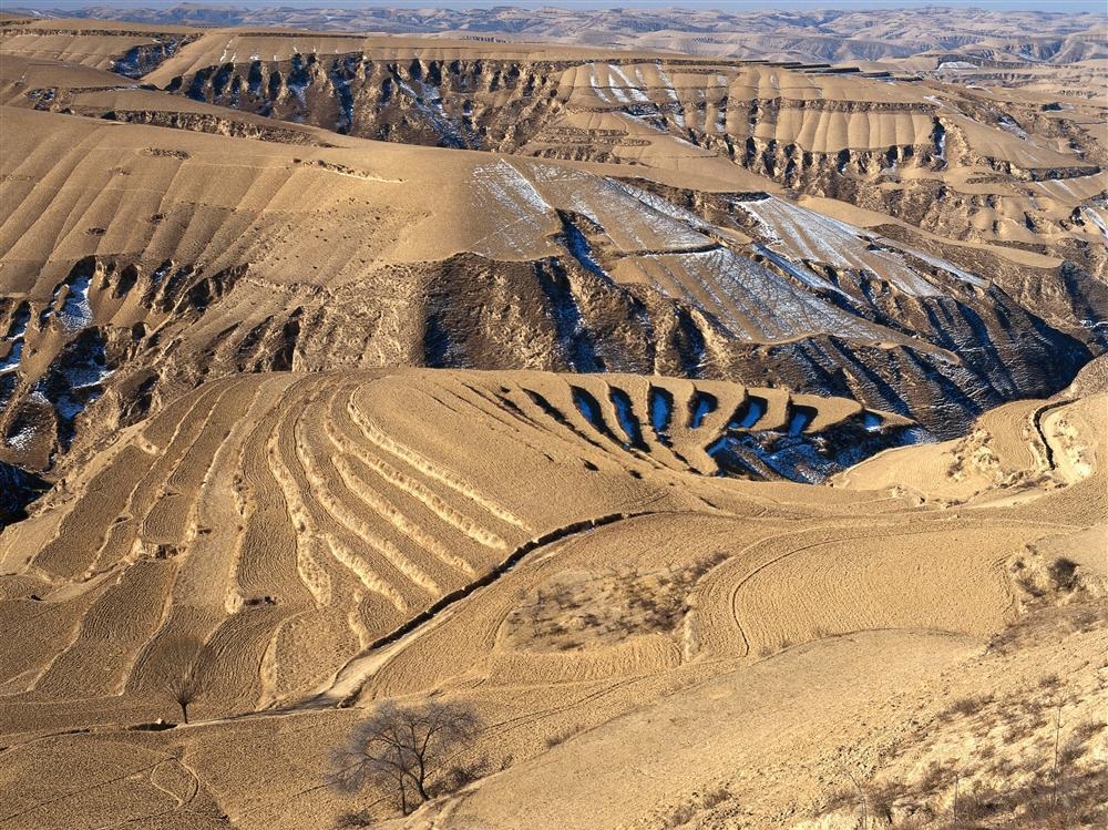
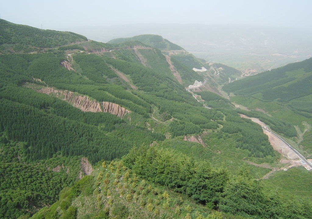
Das Lössplateau, Löss-Hochland (Huangtu gaoyuan 黃土高原) oder Löss-Bergland in Huabei (Nordchina) ist eine Hochlandstufe, die den Übergang vom Nordchinesischen Tiefland zum Hochland der (Inneren) Mongolei im Norden sowie dem Hochland von Tibet im Westen darstellt. Der Südrand wird durch die ebenfalls von Löss geprägten Gebiete im Flusstal des Gelben Flusses sowie dessen wichtigstem Nebenfluss, den Wei He, gebildet, die im Süden von den felsigen Gebirgsketten des Qin Ling überragt werden. Das Lössplateau dehnt sich ungefähr 1000 km ost-westlich und 700 km nord-südlich aus und umfasst weitgehend die Provinzen Shanxi und Shaanxi sowie Teilregionen der Provinzen Hebei, Henan, Gansu, Qinghai und der Inneren Mongolei. Die Lössschichten im Bergland der Provinzen Henan, Shaanxi, Shanxi und Gansu sind bis zu 300 m mächtig.
Traditionell haben die Bewohner dieser Gebiete ihre Behausungen häufig in den Löss hinein gearbeitet. Die Lösswohnungen zeichnen sich durch ein ausgesprochen angenehmes, ausgeglichenes Raumklima aus, das die Temperaturextreme der kalten Winter und heißen Sommer besser abzumildern vermag als moderne Neubauten.
Der Löss ist als äolisches Sediment, das vor allem aus Schluff besteht, ein aus den innerasiatischen Wüsten und Steppen ausgeblasenes Feinmaterial. Der verfestigte Flugstaub ist gelbbraun und äußerst nährstoffreich. Im ostasiatischen Lössbergland finden sich die weltweit mächtigsten Lössablagerungsschichten.
Entlang des Gelben Flusses, der seinen Namen von den mitgeführten Sedimenten hat, steht er in Ablagerungsschichten von bis zu 400 m an. Weltweit verfügt kein Fluss über eine stärkere Sedimentfracht, fast 40 Kilogramm pro Kubikmeter Wasser. Auf Grund der Sedimentation erhöht der Gelbe Fluss sein Bett im Tiefland und muss durch immer höhere Deiche eingedämmt werden. Bei Kaifeng und Zhengzhou liegt der Wasserspiegel bereits zehn Meter über dem Umland.
Anhui Sheng-AH
Gansu Sheng-GS
Hebei Sheng-HE
Henan Sheng-HA
Jiangsu Sheng-JS
Ningxia Huizu Zizhiqu-NX
Qinghai Sheng-QH
Shaanxi Sheng-SN
Shandong Sheng-SD
Shanxi Sheng-SX
Tianjin Shi-TJ
Xinjiang Uygur Zizhiqu-XJ
Zhejiang Sheng-ZJ

| 分片名称 | 主要分布地区 | 说明 |
|---|---|---|
| 郑开片 | 中原北侧:河南郑州、开封、鹤壁、濮阳,冀南大名县、魏县东。 | 属于淮北河南话,毗邻晋语邯新片区及冀鲁官话区。平翘音为郑开型。 |
| 洛嵩片 | 中原西北豫西洛阳市,此片都分布在河南境内。 | 属于淮北河南话,东有郑开片,西有关中片,南有南鲁片,北为晋语邯新片区。以洛阳话为代表。平翘音为洛阳型。 |
| 南鲁片 | 中原西南:豫西南南阳、豫中许昌、平顶山,以及陕东南商南县。 | 属于淮北河南话,东有漯项片,西过渡至西南官话川黔片汉中话,南有信蚌片及西南官话湖广片,北接郑开、洛嵩二片。平翘音为蔡鲁型。 |
| 漯项片 | 中原中央偏西:豫东南漯河、周口、驻马店,此片都分布在河南境内。 | 属于淮北河南话,东有商阜片,西有南鲁片,南有信蚌片,北有郑开片,四面都被中原官话包围。平翘音为蔡鲁型。 |
| 商阜片 | 中原中央偏东:豫东商丘,皖北阜阳、亳州、宿州。 | 属于淮北河南话,东有徐淮片,西有漯项片,南有信蚌片,北有兖菏片及郑开片,四面都被中原官话包围。 |
| 信蚌片 | 中原东南边缘:豫南信阳,皖东北蚌埠。 | 属于淮南河南话,毗邻江淮官话黄孝片及洪巢片宁庐方言区。 |
| 兖菏片 | 中原东北:鲁西南兖州、菏泽、枣庄、郯城、临沂等市,豫东北的范县、台前县,几乎在山东境内。 | 毗邻山东的冀鲁官话区,是山东话的一种,平翘音兼具三种类型。 |
| 徐淮片 | 中原东侧:苏北徐州、宿迁,皖北淮北、宿州,豫东永城市、夏邑县,鲁西南枣庄。 | 位于黄淮平原边界,毗邻江淮官话洪巢片扬淮方言区,平翘音有洛阳型及蔡鲁型。以徐州话为代表。 |
| 汾河片 | 晋南汾河下游的临汾、运城,陕东韩城。 | 与晋语吕梁片有关联,是晋语演化成中原官话的过渡区。是否归属于晋语,目前存在争议。 |
| 关中片 | 陕西西安、铜川、咸阳、渭南、商洛,宁夏泾源县,甘肃宁县,豫西三门峡湖滨区。 | 即关中东府话,以西安话为代表。 |
| 秦陇片 | 陕西宝鸡,宁夏固原,甘肃东南平凉、庆阳、陇南,在青海西宁有方言飞地。 | 即关中西府话。毗邻兰银官话区。 |
| 陇中片 | 甘肃东南天水、定西,宁夏西吉县、隆德县。 | |
| 河州片 | 甘肃临夏回族自治州,青海民和回族土族自治县、循化撒拉族自治县、乐都、同仁。 | 毗邻兰银官话区,词汇多为汉语词,但语法为突厥语架构。 |
| 南疆片 | 甘肃敦煌,新疆塔里木盆地吐鲁番、库尔勒、喀什、和田、阿克苏、阿图什等。 | 包含新疆生产建设兵团河南移民的“团场话”。 |


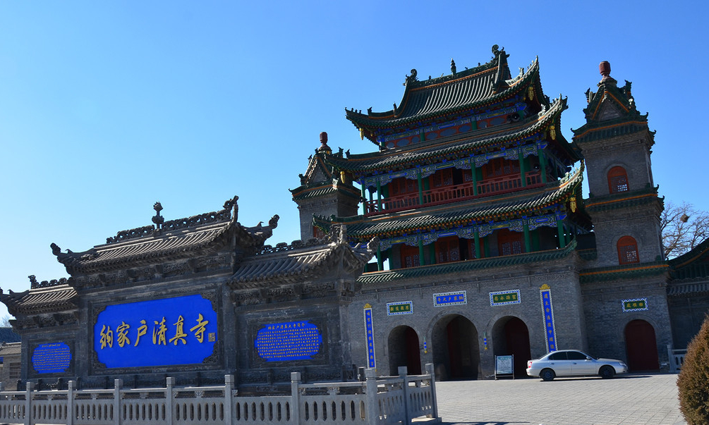
Maulid an-Nabī (arabisch مولد النبي ‚Geburtstag des Propheten‘) ist ein islamisches Fest zu Ehren des Propheten Mohammed. Es wird am 12. Tag des Monats Rabīʿ al-auwal des Islamischen Kalenders gefeiert. In mehreren islamischen Ländern, darunter Indonesien und Malaysia, ist der Tag Staatsfeiertag.[1] In Indonesien wird dieser Festtag auch maulud oder mulud (von arab. maulūd) genannt.
 Architecture
 Religion

 History

Die Nekropole der Tanguten (Xixia) ist eine der weltweit größten Totenstädte mit einer Ausdehnung von etwa 50 km². Die Grabanlagen liegen am Fuß des Helan-Gebirges in der autonomen Region Ningxia, 40 km westlich von der Provinzhauptstadt Yinchuan.
Auf dem bisher wenig erforschten Gelände befinden sich neun Königsgräber und etwa 250 Grabanlagen von Beamten und Notablen der Tanguten. Insbesondere die 25 bis 30 m hohen, meist von einem Mauerring eingefassten Königsgräber spiegeln den Reichtum der tangutischen Herrscher wider. In ihrem Inneren befinden sich kunstvoll bemalte Grabkammern und Statuen.Die Anlage wurde Anfang des 20. Jahrhunderts von europäischen Zentralasien-Reisenden wie Sven Hedin und Aurel Stein bekannt gemacht und 1938 von Wulf-Dieter Graf zu Castell erstmals aus der Luft fotografiert. Heute sind chinesische Archäologen vor allem bemüht, die Gebäude der Anlage zu erhalten und den Originalzustand der gefundenen Statuetten und Grabkammern zu konservieren.
 Transport and traffic
Beijing Shi-BJ
Belarus
Transport and traffic
Beijing Shi-BJ
Belarus
 Berlin
 Brandenburg
 Bremen
China
Germany
France
Gansu Sheng-GS
Bremen
China
Germany
France
Gansu Sheng-GS
 Hamburg
Hebei Sheng-HE
Heilongjiang Sheng-HL
Henan Sheng-HA
Hubei Sheng-HB
Hunan Sheng-HN
Iran
Italy
Jilin Sheng-JL
Kasachstan
Liaoning Sheng-LN
Nei Mongol Zizhiqu-NM
Netherlands
Hamburg
Hebei Sheng-HE
Heilongjiang Sheng-HL
Henan Sheng-HA
Hubei Sheng-HB
Hunan Sheng-HN
Iran
Italy
Jilin Sheng-JL
Kasachstan
Liaoning Sheng-LN
Nei Mongol Zizhiqu-NM
Netherlands
 Lower Saxony
Ningxia Huizu Zizhiqu-NX
Lower Saxony
Ningxia Huizu Zizhiqu-NX
 North Rhine-Westphalia
Poland
Portugal
Russia
North Rhine-Westphalia
Poland
Portugal
Russia
 Saxony
 Schleswig-Holstein
Shaanxi Sheng-SN
Shandong Sheng-SD
Shanxi Sheng-SX
Sichuan Sheng-SC
Spain
Turkey
Turkmenistan
Uzbekistan
United Kingdom
Xinjiang Uygur Zizhiqu-XJ
Zhejiang Sheng-ZJ
Schleswig-Holstein
Shaanxi Sheng-SN
Shandong Sheng-SD
Shanxi Sheng-SX
Sichuan Sheng-SC
Spain
Turkey
Turkmenistan
Uzbekistan
United Kingdom
Xinjiang Uygur Zizhiqu-XJ
Zhejiang Sheng-ZJ
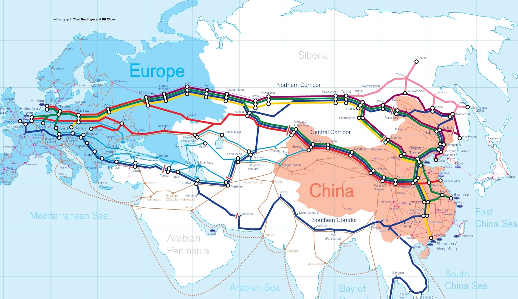
Die Neue eurasische Kontinentalbrücke (chinesisch 新亚欧大陆桥, Pinyin Xīn Yà-Ōu Dàlù Qiáo, englisch New Eurasian Continental Bridge), die auch Zweite eurasische Kontinentalbrücke (第二亚欧大陆桥, Dì'èr Yà-Ōu Dàlù Qiáo, englisch Second Eurasian Continental Bridge) genannt wird, ist eine 10.870 Kilometer[1] lange Eisenbahnverbindung, die Rotterdam in Europa mit der ostchinesischen Hafenstadt Lianyungang in der Provinz Jiangsu verbindet.
Sie besteht seit 1990 und führt durch die Dsungarische Pforte (Grenzbahnhof Alashankou). Die Lan-Xin-Bahn (chinesisch 兰新铁路, Pinyin Lán-Xīn Tiělù), also die Strecke von Lanzhou nach Ürümqi (in Xinjiang), ist ein Teil von ihr.
Es gibt eine nördliche, mittlere und südliche Route.[2] Die mittlere Strecke verläuft durch Kasachstan über Dostyk, Aqtogai, Astana, Samara, Smolensk, Brest, Warschau, Berlin zum Hafen von Rotterdam.[3] Vom slowakischen Košice soll auch eine Abzweigung in den Großraum Wien führen, siehe Breitspurstrecke Košice–Wien.
The New Eurasian Land Bridge, also called the Second or New Eurasian Continental Bridge, is the southern branch of the Eurasian Land Bridge rail links running through China. The Eurasian Land Bridge is the overland rail link between Asia and Europe.
Due to a break-of-gauge between standard gauge used in China and the Russian gauge used in the former Soviet Union countries, containers must be physically transferred from Chinese to Kazakh railway cars at Dostyk on the Chinese-Kazakh border and again at the Belarus-Poland border where the standard gauge used in western Europe begins. This is done with truck-mounted cranes.[1] Chinese media often states that the New Eurasian Land/Continental Bridge extends from Lianyungang to Rotterdam, a distance of 11,870 kilometres (7,380 mi). The exact route used to connect the two cities is not always specified in Chinese media reports, but appears to usually refer to the route which passes through Kazakhstan.
All rail freight from China across the Eurasian Land Bridge must pass north of the Caspian Sea through Russia at some point. A proposed alternative would pass through Turkey and Bulgaria,[2] but any route south of the Caspian Sea must pass through Iran.[1]
Kazakhstan's President Nursultan Nazarbayev urged Eurasian and Chinese leaders at the 18th Shanghai Cooperation Organisation to construct the Eurasian high-speed railway (EHSRW) following a Beijing-Astana-Moscow-Berlin.[3]
The Eurasian Land Bridge (Russian: Евразийский сухопутный мост, Yevraziyskiy sukhoputniy most), sometimes called the New Silk Road (Новый шёлковый путь, Noviy shyolkoviy put'), or Belt and Road Initiative is the rail transport route for moving freight and passengers overland between Pacific seaports in the Russian Far East and China and seaports in Europe. The route, a transcontinental railroad and rail land bridge, currently comprises the Trans-Siberian Railway, which runs through Russia and is sometimes called the Northern East-West Corridor, and the New Eurasian Land Bridge or Second Eurasian Continental Bridge, running through China and Kazakhstan. As of November 2007, about 1% of the $600 billion in goods shipped from Asia to Europe each year were delivered by inland transport routes.[1]
Completed in 1916, the Trans-Siberian connects Moscow with Russian Pacific seaports such as Vladivostok. From the 1960s until the early 1990s the railway served as the primary land bridge between Asia and Europe, until several factors caused the use of the railway for transcontinental freight to dwindle. One factor is that the railways of the former Soviet Union use a wider rail gauge than most of the rest of Europe as well as China. Recently, however, the Trans-Siberian has regained ground as a viable land route between the two continents.[why?]
China's rail system had long linked to the Trans-Siberian via northeastern China and Mongolia. In 1990 China added a link between its rail system and the Trans-Siberian via Kazakhstan. China calls its uninterrupted rail link between the port city of Lianyungang and Kazakhstan the New Eurasian Land Bridge or Second Eurasian Continental Bridge. In addition to Kazakhstan, the railways connect with other countries in Central Asia and the Middle East, including Iran. With the October 2013 completion of the rail link across the Bosphorus under the Marmaray project the New Eurasian Land Bridge now theoretically connects to Europe via Central and South Asia.
Proposed expansion of the Eurasian Land Bridge includes construction of a railway across Kazakhstan that is the same gauge as Chinese railways, rail links to India, Burma, Thailand, Malaysia and elsewhere in Southeast Asia, construction of a rail tunnel and highway bridge across the Bering Strait to connect the Trans-Siberian to the North American rail system, and construction of a rail tunnel between South Korea and Japan. The United Nations has proposed further expansion of the Eurasian Land Bridge, including the Trans-Asian Railway project.
El Nuevo Puente de Tierra de Eurasia es también llamado el Segundo o Nuevo Puente Continental de Eurasia. Es la rama meridional de las conexiones ferroviarias del Puente de Tierra de Eurasia (también conocido como "Nueva Ruta de la Seda") que se extienden a través de la República Popular China, atravesando Kazajistán, Rusia y Bielorrusia. El Puente de Tierra de Eurasia es el enlace ferroviario terrestre entre Asia Oriental y Europa.
La Nueva Ruta de la Seda (en ruso, Новый шёлковый путь, Noviy shyolkoviy put), o Puente Terrestre Euroasiático, es la ruta de transporte ferroviario para el movimiento de tren de mercancías y tren de pasajeros por tierra entre los puertos del Pacífico, en el Lejano Oriente ruso y chino y los puertos marítimos en Europa.
La ruta, un ferrocarril transcontinental y puente terrestre, actualmente comprende el ferrocarril Transiberiano, que se extiende a través de Rusia, y el nuevo puente de tierra de Eurasia o segundo puente continental de Eurasia, que discurre a través de China y Kazajistán, también se van a construir carreteras entre las ciudades de la ruta. A partir de noviembre de 2007, aproximadamente el 1% de los 600 millones de dólares en bienes enviados desde Asia a Europa cada año se entregaron por vías de transporte terrestre.1
Terminado en 1916, el tren Transiberiano conecta Moscú con el lejano puerto de Vladivostok en el océano Pacífico, el más largo del mundo en el Lejano Oriente e importante puerto del Pacífico. Desde la década de 1960 hasta principios de 1990 el ferrocarril sirvió como el principal puente terrestre entre Asia y Europa, hasta que varios factores hicieron que el uso de la vía férrea transcontinental para el transporte de carga disminuyese.
Un factor es que los ferrocarriles de la Unión Soviética utilizan un ancho de vía más ancho en los rieles que la mayor parte del resto de Europa y China, y el transporte en barcos de carga por el canal de Suez en Egipto, construido por Inglaterra. El sistema ferroviario de China se une al Transiberiano en el noreste de China y Mongolia. En 1990 China añadió un enlace entre su sistema ferroviario y el Transiberiano a través de Kazajistán. China denomina a su enlace ferroviario ininterrumpido entre la ciudad portuaria de Lianyungang y Kazajistán como el «Puente terrestre de Nueva Eurasia» o «Segundo puente continental Euroasiático». Además de Kazajistán, los ferrocarriles conectan con otros países de Asia Central y Oriente Medio, incluyendo a Irán. Con la finalización en octubre de 2013 de la línea ferroviaria a través del Bósforo en el marco del proyecto Marmaray el puente de tierra de Nueva Eurasia conecta ahora teóricamente a Europa a través de Asia Central y del Sur.
La propuesta de ampliación del Puente Terrestre Euroasiático incluye la construcción de un ferrocarril a través de Kazajistán con el mismo ancho de vía que los ferrocarriles chinos, enlaces ferroviarios a la India, Birmania, Tailandia, Malasia y otros países del sudeste asiático, la construcción de un túnel ferroviario y un puente de carretera a través del estrecho de Bering para conectar el Transiberiano al sistema ferroviario de América del Norte, y la construcción de un túnel ferroviario entre Corea del Sur y Japón. Las Naciones Unidas ha propuesto una mayor expansión del Puente Terrestre Euroasiático, incluyendo el proyecto del ferrocarril transasiático.
Новый шёлковый путь (Евразийский сухопутный мост — концепция новой паневразийской (в перспективе — межконтинентальной) транспортной системы, продвигаемой Китаем, в сотрудничестве с Казахстаном, Россией и другими странами, для перемещения грузов и пассажиров по суше из Китая в страны Европы. Транспортный маршрут включает трансконтинентальную железную дорогу — Транссибирскую магистраль, которая проходит через Россию и второй Евразийский континентальный мост[en], проходящий через Казахстан[1]. Поезда по этому самому длинному в мире грузовому железнодорожному маршруту из Китая в Германию будут идти 15 дней, что в 2 раза быстрее, чем по морскому маршруту через Суэцкий канал[2].
Идея Нового шёлкового пути основывается на историческом примере древнего Великого шёлкового пути, действовавшего со II в. до н. э. и бывшего одним из важнейших торговых маршрутов в древности и в средние века. Современный НШП является важнейшей частью стратегии развития Китая в современном мире — Новый шёлковый путь не только должен выстроить самые удобные и быстрые транзитные маршруты через центр Евразии, но и усилить экономическое развитие внутренних регионов Китая и соседних стран, а также создать новые рынки для китайских товаров (по состоянию на ноябрь 2007 года, около 1 % от товаров на 600 млрд долл. из Азии в Европу ежегодно доставлялись наземным транспортом[3]).
Китай продвигает проект «Нового шёлкового пути» не просто как возрождение древнего Шёлкового пути, транспортного маршрута между Востоком и Западом, но как масштабное преобразование всей торгово-экономической модели Евразии, и в первую очередь — Центральной и Средней Азии. Китайцы называют эту концепцию — «один пояс — один путь». Она включает в себя множество инфраструктурных проектов, которые должны в итоге опоясать всю планету. Проект всемирной системы транспортных коридоров соединяет Австралию и Индонезию, всю Центральную и Восточную Азию, Ближний Восток, Европу, Африку и через Латинскую Америку выходит к США. Среди проектов в рамках НШП планируются железные дороги и шоссе, морские и воздушные пути, трубопроводы и линии электропередач, и вся сопутствующая инфраструктура. По самым скромным оценкам, НШП втянет в свою орбиту 4,4 миллиарда человек — более половины населения Земли[4].
Предполагаемое расширение Евразийского сухопутного моста включает в себя строительство железнодорожных путей от трансконтинентальных линий в Иран, Индию, Мьянму, Таиланд, Пакистан, Непал, Афганистан и Малайзию, в другие регионы Юго-Восточной Азии и Закавказья (Азербайджан, Грузия). Маршрут включает тоннель Мармарай под проливом Босфор, паромные переправы через Каспийское море (Азербайджан-Иран-Туркменистан-Казахстан) и коридор Север-Юг.Организация Объединенных Наций предложила дальнейшее расширение Евразийского сухопутного моста, в том числе проекта Трансазиатской железной дороги (фактически существует уже в 2 вариантах).
Для развития инфраструктурных проектов в странах вдоль Нового шёлкового пути и Морского Шёлкового пути и с целью содействия сбыту китайской продукции в декабре 2014 года был создан инвестиционный Фонд Шёлкового пути[5].
8 мая 2015 года было подписано совместное заявление Президента РФ В. Путина и Председателя КНР Си Цзиньпина о сотрудничестве России и Китая, в рамках ЕАЭС и трансевразийского торгово-инфраструктурного проекта экономического пояса «Шёлковый путь». 13 июня 2015 года был запущен самый длинный в мире грузовой железнодорожный маршрут Харбин — Гамбург (Германия), через территорию России.