
漢德百科全書 | 汉德百科全书
 Mexico

 Geography
 Caribbean
 Mexico

 Party and government
 Group of the twenty most important industrial and emerging countries


Mexiko (spanisch: México oder Méjico [ˈmexiko], nahuatl: Mexihco [meː'ʃiʔko]), amtlich Vereinigte Mexikanische Staaten, spanisch: Estados Unidos Mexicanos, ist eine Bundesrepublik in Nordamerika, die 31 Bundesstaaten und den Hauptstadtdistrikt Mexiko-Stadt umfasst. Im Norden grenzt Mexiko an die Vereinigten Staaten von Amerika (USA), im Süden und Westen an den Pazifischen Ozean, im Südosten an Guatemala, Belize und an das Karibische Meer, im Osten an den Golf von Mexiko. Mit einer Gesamtfläche von fast zwei Millionen Quadratkilometern ist Mexiko das fünftgrößte Land auf dem amerikanischen Doppelkontinent, global liegt das Land an vierzehnter Stelle. Weltweit liegt Mexiko mit einer Bevölkerungszahl von etwa 125 Millionen Menschen auf Platz elf und ist das einwohnerreichste spanischsprachige Land.
墨西哥合众国(西班牙语:Estados Unidos Mexicanos, ![]() 聆听 帮助·信息)[9][10][11][12],通称墨西哥(西班牙语:México [ˈmexiko]
聆听 帮助·信息)[9][10][11][12],通称墨西哥(西班牙语:México [ˈmexiko] ![]() 聆听),是北美洲的一个联邦共和制主权国家,北部同美国接壤,南侧和西侧滨临太平洋,东南为伯利兹、危地马拉和加勒比海,东部则为墨西哥湾[13]。其面积达近二百万平方公里(超过760,000平方英里)[12],为美洲面积第五大国家和世界面积第十四大国家。其总人口超过1.3亿[14],为世界第十人口大国,西班牙语世界第一人口大国及拉丁美洲第二人口大国。墨西哥为联邦国家,包括三十二个州;其首都和最大城市墨西哥城亦为一州。
聆听),是北美洲的一个联邦共和制主权国家,北部同美国接壤,南侧和西侧滨临太平洋,东南为伯利兹、危地马拉和加勒比海,东部则为墨西哥湾[13]。其面积达近二百万平方公里(超过760,000平方英里)[12],为美洲面积第五大国家和世界面积第十四大国家。其总人口超过1.3亿[14],为世界第十人口大国,西班牙语世界第一人口大国及拉丁美洲第二人口大国。墨西哥为联邦国家,包括三十二个州;其首都和最大城市墨西哥城亦为一州。
前哥伦布时期的墨西哥为诸多先进的中部美洲文明发源地,如奥尔梅克、托尔特克、特奥蒂瓦坎、萨波特克、玛雅和阿兹特克等。1521年,西班牙帝国以墨西哥-特诺奇提特兰为基点征服并殖民了这一地区,并将之建制为新西班牙总督辖区。1821年,在墨西哥独立战争之后,这一辖区宣布独立并受承认为墨西哥。独立后的墨西哥经历了一段动荡期,经济和政治均不稳定。美墨战争(1846–48)后其被迫将位于北部的近三分之一领土割让给美国。19世纪的墨西哥经历了糕点战争、法墨战争、内战、两个帝国以及一段独裁时期。1910年开始的墨西哥革命推翻了独裁统治,最终促成了1917年宪法的订立和现行政治体制的建立。
墨西哥的名义国内生产总值为世界第十五大,国际生产总值(购买力平价)为世界第十一大。墨西哥经济与其北美自由贸易协议(NAFTA)贸易伙伴紧密相关,尤其是美国[15][16]。自1994年起,墨西哥为经济合作与发展组织的首个拉丁美洲成员国。世界银行将其归为中高收入国家[17],分析人士亦称其为一新兴工业化国家[18][19][20][21]。估计至2050年,墨西哥将成为全球第五或第七大经济体[22][23]。该国被认为是一地域大国和中等强国[24][25][26][27],并时常被认为是一新兴强国[28]。墨西哥文化历史遗产丰富,拥有美洲数量第五多和世界第六多的联合国教科文组织世界遗产[29][30][31]。2015年其为世界访客数量第十的国家,国际来访人次达2910万[32][33]。墨西哥为联合国、世界贸易组织、G20峰会和团结谋共识成员国,2014年起成为法语圈国际组织观察员。
メキシコ合衆国(メキシコがっしゅうこく、スペイン語: Estados Unidos Mexicanos)、通称メキシコは、北アメリカ南部に位置する連邦共和制国家。北にアメリカ合衆国と南東にグアテマラ、ベリーズと国境を接し、西は太平洋、東はメキシコ湾とカリブ海に面する。首都はメキシコシティ。メキシコの総人口は約1億3,000万人(2016年時点)で、スペイン語圏においてはもっとも人口の多い国である。GDPは中南米2位[注釈 1]。
Mexico (Spanish: México [ˈmexiko] (![]() listen); Nahuan languages: Mēxihco), officially the United Mexican States (Spanish: Estados Unidos Mexicanos; EUM [esˈtaðos uˈniðoz mexiˈkanos] (
listen); Nahuan languages: Mēxihco), officially the United Mexican States (Spanish: Estados Unidos Mexicanos; EUM [esˈtaðos uˈniðoz mexiˈkanos] (![]() listen)), is a country in the southern portion of North America. It is bordered to the north by the United States; to the south and west by the Pacific Ocean; to the southeast by Guatemala, Belize, and the Caribbean Sea; and to the east by the Gulf of Mexico.[10] Mexico covers 1,972,550 square kilometers (761,610 sq mi)[11] and has approximately 128,649,565 inhabitants,[4] making it the world's 13th-largest country by area, 10th-most populous country, and most populous Spanish-speaking nation. It is a federation comprising 31 states and Mexico City,[12] its capital city and largest metropolis. Other major urban areas include Guadalajara, Monterrey, Puebla, Toluca, Tijuana, Ciudad Juárez, and León.[13]
listen)), is a country in the southern portion of North America. It is bordered to the north by the United States; to the south and west by the Pacific Ocean; to the southeast by Guatemala, Belize, and the Caribbean Sea; and to the east by the Gulf of Mexico.[10] Mexico covers 1,972,550 square kilometers (761,610 sq mi)[11] and has approximately 128,649,565 inhabitants,[4] making it the world's 13th-largest country by area, 10th-most populous country, and most populous Spanish-speaking nation. It is a federation comprising 31 states and Mexico City,[12] its capital city and largest metropolis. Other major urban areas include Guadalajara, Monterrey, Puebla, Toluca, Tijuana, Ciudad Juárez, and León.[13]
Pre-Columbian Mexico traces its origins to 8,000 BC and is identified as one of six cradles of civilization;[14] it was home to many advanced Mesoamerican civilizations, most well-known among them the Maya and the Aztecs. In 1521, the Spanish Empire conquered and colonized the territory from its base in Mexico City, which then became known as New Spain. The Catholic Church played an important role as millions of indigenous inhabitants converted. These populations were heavily exploited to mine rich deposits of precious material, which became a major source of wealth for the Spanish.[15] Mexico became an independent nation state after the successful Mexican War of Independence against Spain in 1821.[16]
The War of Texas Independence in 1836 and the Mexican–American War led to huge territorial losses in Mexico's sparsely populated north, contiguous to the United States. The newly instituted reforms that granted protection to indigenous communities, and curtailed the power of the military and the church, were enshrined in the Constitution of 1857. This triggered the War of the Reform and French intervention. Maximilian Habsburg was installed as emperor by France and Benito Juárez kept an opposing republican government in exile. The following decades were marked by instability and dictatorship of Porfirio Díaz, who sought to modernize Mexico and restore order.[16] The Porfiriato ended with the Mexican Revolution in 1910 and the winning Constitutionalist faction drafted a new 1917 Constitution. The revolutionary generals of the winning northern faction dominated the 1920s and served as presidents, but the 1928 assassination of Alvaro Obregón led to the formation of the Institutional Revolutionary Party in 1929, under which Mexico was a one-party state until 2000.[17][18][19][20]
Mexico is a developing country, ranking 76th on the Human Development Index, but is considered a newly industrialized state by several analysts.[21][22][23][24] It has the world's 15th-largest economy by nominal GDP and the 11th-largest by PPP, with the United States being its largest economic partner.[25][26] The large economy, area, population and politics make Mexico a regional power and a middle power,[27][28][29][30] and is often identified as an emerging power.[31] However, Mexico continues to struggle with social inequalities, poverty and extensive crime; the country ranks poorly on the Global Peace Index.[32] Since 2006, the conflict between the government and drug trafficking syndicates lead to over 120,000 deaths.[33]
Mexico ranks first in the Americas and 7th in the world for the number of UNESCO World Heritage Sites.[34][35][36] Mexico is an ecologically megadiverse country, ranking 5th in the world for its natural biodiversity.[37] Mexico receives a significant number of tourists every year; in 2018, it was the 6th most-visited country in the world, with 39 million international arrivals.[38] Mexico is a member of the United Nations (UN), the World Trade Organization (WTO), the G8+5, the G20, the Uniting for Consensus group of the UN, and the Pacific Alliance trade bloc.
Le Mexique, en forme longue les États-Unis Mexicains11,12,13, en espagnol México et Estados Unidos Mexicanos14 ou EUM, est un pays situé dans la partie méridionale de l'Amérique du Nord.
Délimité à l'est-sud-est par le Guatemala et le Belize, et au nord-nord-ouest par les États-Unis d'Amérique, il est bordé à l'est par le Golfe du Mexique et la mer des Caraïbes et au sud-ouest par l'océan Pacifique. C'est le quatorzième pays en superficie, avoisinant 2 millions de km2.
Avec une population estimée en mai 2018 à 130,5 millions d'habitants par l'Organisation des Nations unies15, le Mexique se classe au onzième rang mondial des pays les plus peuplés16. Plus de 98 % des Mexicains parlent l'espagnol mexicain, et plus de 7 millions (environ 6 %) parlent une langue indigène ; la loi mexicaine les reconnaît comme langues nationales depuis 2003, mais aucune ne possède le statut de langue officielle. Politiquement, le Mexique est une république constitutionnelle fédérale, composée de trente-deux entités fédératives dont trente et une ont le statut d'État, Mexico n'ayant pas ce statut17 car abritant la capitale politique du pays18.
La présence humaine au Mexique remonte à plus de 30 000 ans avant le présent19,20,21. Après des millénaires de développement culturel sont apparues les cultures mésoaméricaines, aridaméricaines et oasisaméricaines. Avant les premiers contacts avec les Européens, vivaient diverses civilisations, telles que les Olmèques, les Toltèques, les Zapotèques, les Mayas, et les Aztèques. En 1521, l'Espagne conquit et colonisa le territoire depuis Mexico-Tenochtitlan, qui devint la capitale de la vice-royauté de Nouvelle-Espagne. Après près de trois cents ans de colonisation espagnole, le territoire débuta une guerre d'indépendance contre l'Espagne en 1810, qui dans la foulée déclara sa séparation en 1813 pour établir le Mexique, avant de sortir victorieux en 1821. Le pays connaît ensuite un demi-siècle d'instabilité politique et financière, caractérisé par divers conflits dont une tentative de reconquête par l'Espagne en 1829, la guerre des Pâtisseries, une guerre contre les États-Unis, une guerre civile, une intervention française, trois républiques et deux Empires. Durant la présidence de Porfirio Díaz, le pays a connu une période de modernisation et de croissance économique importante. Díaz fut renversé à la suite d'une révolution en 1910, qui culmina avec la constitution de 1917 et la mise en place du système politique actuel.
Le Mexique fait partie des vingt premières puissances économiques mondiales (quinzième avec un PIB de 1 149 milliards de dollars en 2017)22. Mesuré en parité de pouvoir d'achat, son PIB arrive à la onzième place, devant l'Italie23. Le Mexique est le neuvième plus grand producteur de pétrole au monde et le premier producteur d'argent. Puissance émergente, puissance moyenne à l'échelle mondiale et puissance régionale, le Mexique est le premier pays d'Amérique latine à avoir rejoint l'OCDE. Classé parmi les nouveaux pays industrialisés24, il s'agit, selon la Banque mondiale, d'un pays à revenu intermédiaire supérieur. Son économie est fortement liée à celle des États-Unis, par son appartenance à l'ALENA. Selon l'organisation mondiale du tourisme, le Mexique est la principale destination d'Amérique latine et la treizième plus visitée au monde. En plus d’être l'un des dix-sept pays mégadivers de la planète (il abrite de 10 à 12 % de la biodiversité mondiale et comprend plus de douze mille espèces endémiques), il compte 33 sites culturels ou naturels inscrits par l'UNESCO au patrimoine de l'humanité. D'après le rapport de 2013 sur le développement humain El ascenso del sur de l'ONU, l'indice de développement humain du Mexique s'élève à 0,775 unités, et occupe la 61e place mondiale (au côté de l’Indonésie, la Turquie, la Thaïlande, et l'Afrique du Sud) alors qu'en 1980 son indice ne s'élevait qu'à 0,598 unités. Le Mexique est également membre d'institutions internationales de grande envergure, telles que l'ONU, l'OMC et le G20.
Le Mexique était membre de l'Accord de libre-échange nord-américain (ALENA, ou « TLCAN » en espagnol, « NAFTA » en anglais) jusqu’en 2018. Cet accord a été remplacé par l’Accord Canada–États-Unis–Mexique (ACEUM) en décembre 2018, et avec la récente modernisation en 2020 de l'accord de libre-échange entre les États-Unis, le Canada et le Mexique, il s'appelle désormais T-MEC.
Il Messico (spagnolo: México[4]; nahuatl: Mēxihco), ufficialmente gli Stati Uniti Messicani (spagnolo: Estados Unidos Mexicanos; nahuatl: Mēxihcatl Tlacetilīlli Tlahtohcāyōtl), è una democrazia rappresentativa composta da trentuno Stati. Secondo la Costituzione messicana la sede dei poteri della federazione e capitale dello Stato è Città del Messico. Occupa la parte meridionale dell'America settentrionale, e la parte settentrionale dell'America Latina. Il Messico è delimitato a nord dal confine con gli Stati Uniti d'America, a est dal golfo del Messico e dal mare Caraibico, a sud-est dal Belize e dal Guatemala e a ovest dall'oceano Pacifico. Con una superficie di 1.972.550 km² il Messico è il 14° paese più esteso del mondo mentre con 128.649.565 persone[5], oltre ad essere il 10° paese più popoloso del mondo è anche il più popoloso paese ispanofono e il secondo più popoloso di religione cattolica dopo il Brasile. Lo spagnolo è parlato in Messico con molte lingue indigene, ufficialmente riconosciute.
L'insediamento umano in questo territorio risale a circa undicimila anni fa e da allora si succedettero svariati popoli, sia agricoltori della Mesoamerica sia nomadi. Dopo la conquista spagnola il Messico cominciò la sua lotta per l'indipendenza politica nel 1810. In seguito per quasi un secolo il paese è stato coinvolto in una serie di guerre interne e d'invasioni straniere che hanno avuto un impatto forte in tutti gli ambiti della vita messicana. Per la maggior parte del XX secolo (principalmente per la prima metà) si assistette a un periodo di forte crescita economica nel contesto di una politica dominata da un unico partito politico.
Per volume di prodotto interno lordo (PIL) nominale il Messico è considerata la quattordicesima economia mondiale.[2] Tuttavia la distribuzione della ricchezza è estremamente diseguale, tanto che gli indici di sviluppo umano possono variare enormemente fra zona e zona del paese.[6][7] Per una buona parte del XX secolo la principale fonte di ricchezza del paese è stato il petrolio, anche se il processo di industrializzazione del paese ha permesso la diversificazione dell'economia. Le rimesse dei lavoratori all'estero sono aumentate di anno in anno e rappresentano il 3% del PIL costituendo un'importante fonte di valuta estera per il paese, accanto ai proventi delle esportazioni di petrolio e del turismo.[8][9] Dopo la cattura di Pablo Escobar la lotta per il controllo delle rotte della droga per gli Stati Uniti d'America attraverso il Messico ha prodotto una vera e propria guerra civile tra i vari cartelli della droga, che ha portato a oltre 100.000 morti.
Il Messico è una potenza regionale[10][11] e uno dei due paesi dell'America Latina insieme al Cile a essere membro dell'Organizzazione per la cooperazione e lo sviluppo economico (OCSE).
Méxiconota 1 (![]() [ˈmexiko]), oficialmente los Estados Unidos Mexicanos,18192021 es un país soberano ubicado en la parte meridional de América del Norte; su capital y ciudad más poblada es la Ciudad de México.22 Políticamente es una república representativa, democrática, federal y laica, compuesta por 32 entidades federativas (31 estados y una capital federal).2324
[ˈmexiko]), oficialmente los Estados Unidos Mexicanos,18192021 es un país soberano ubicado en la parte meridional de América del Norte; su capital y ciudad más poblada es la Ciudad de México.22 Políticamente es una república representativa, democrática, federal y laica, compuesta por 32 entidades federativas (31 estados y una capital federal).2324
El territorio mexicano tiene una superficie de 1 964 375 km²,25 por lo que es el decimotercer país más extenso del mundo y el tercero más grande de América Latina. Limita al norte con los Estados Unidos de América a lo largo de una frontera de 3155 km, mientras que al sur tiene una frontera de 958 km con Guatemala y 276 km con Belice. Las costas del país limitan al oeste con el océano Pacífico y al este con el golfo de México y el mar Caribe, sumando 9330 km, por lo que es el tercer país americano con mayor longitud de litoral.26
México es el undécimo país más poblado del mundo, con una población estimada en más de 126 millones de personas en 2019.9 La mayoría de ellas tiene como lengua materna el español, al que el estado reconoce como lengua nacional junto a 67 lenguas indígenas propias de la nación,27 si bien en el país se hablan alrededor de 287 idiomas.28 Estas cifras convierten a México en el país con mayor número de hispanohablantes,29 así como en el séptimo país con mayor diversidad lingüística en el mundo.30
La presencia humana en México se remonta a 30 000 años antes del presente.31 Como fruto de miles de años de desarrollo cultural surgieron en el territorio mexicano las culturas mesoamericanas, aridoamericanas y oasisamericanas. El actual territorio central de México fue el principal y mayor escenario del pueblo mexica y, en parte, del pueblo maya, dos de las civilizaciones más importantes de la América precolombina. Durante 300 años, la totalidad del actual territorio formó parte del Virreinato de N
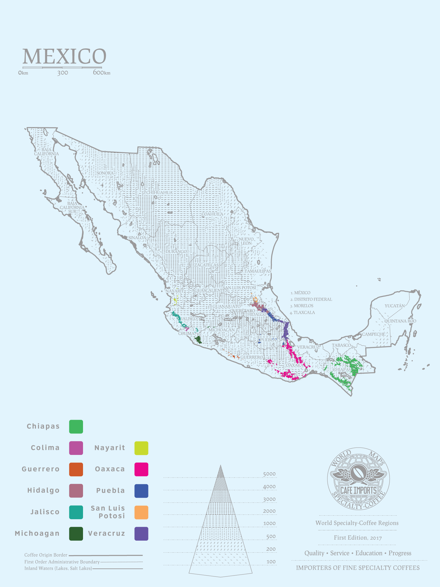
Mit einer Fläche von 1.964.375 km² belegt Mexiko Rang 14 aller Länder in der Welt.
Das Klima reicht von tropisch bis Wüste.
Die Landschaft reicht von hohen felsigen Bergen über niedrige Küstenebenen und Hochland bis hin zur Wüste.
In der Sonora-Wüste liegt der ausgetrockneten See Laguna Salada 10m unter dem Meeresspiegel. Den höchsten Punkt markiert der Vulkan Pico de Orizaba mit einer Höhe von 5.700m.



 Alabama-AL
 Cuba
Cuba

 Florida-FL

 Louisiana-LA
 Mexico
 Mississippi River

 Mississippi-MS

 Texas-TX
 United States

Der Golf von Mexiko (englisch Gulf of Mexico, spanisch Golfo de México; veraltet: Meerbusen von Mexiko[1]) ist eine nahezu vollständig von Nordamerika eingeschlossene Meeresbucht. Der Golf ist ein Randmeer des Atlantischen Ozeans und der nordwestliche Teil des Amerikanischen Mittelmeers.
墨西哥湾是北美洲南部大西洋的一海湾,以佛罗里达半岛-古巴-犹加敦半岛一线与外海分割。北为美国,南、西为墨西哥,东南为古巴,东经佛罗里达海峡与大西洋相连,经尤卡坦海峡与加勒比海相接,是著名的墨西哥湾暖流的起点。墨西哥湾形成于3亿年前的地球板块运动。[1]
湾の東部、北部、および北西部の海岸線はアメリカ合衆国(フロリダ州、アラバマ州、ミシシッピ州、ルイジアナ州、テキサス州)に接し、南西部と南部の海岸線はメキシコ(タマウリパス州、ベラクルス州、タバスコ州、カンペーチェ州、ユカタン州およびキンタナ・ロー州)に接している。また南東部はキューバとの海岸線をもつ。
アメリカとキューバの間にあるフロリダ海峡を経て大西洋に通じており、メキシコとキューバの間にあるユカタン海峡を経てカリブ海へと通じている。支湾として北東部にアパラチー湾、南西部にカンペチェ湾などがある。
メキシコ湾は東西の幅が約1,500km、総面積は約160万 km²で、南の3分の1は熱帯に入る。最大水深はSigsbee Deepでの4,384m。二大海流として黒潮と共に知られるメキシコ湾流はここを起源とし、巨大ハリケーンが頻繁に訪れることでも有名である。
The Gulf of Mexico (Spanish: Golfo de México) is an ocean basin and a marginal sea of the Atlantic Ocean,[1] largely surrounded by the North American continent.[2] It is bounded on the northeast, north and northwest by the Gulf Coast of the United States, on the southwest and south by the Mexican states of Tamaulipas, Veracruz, Tabasco, Campeche, Yucatan, and Quintana Roo, and on the southeast by Cuba. The US states of Texas, Louisiana, Mississippi, Alabama, and Florida border the Gulf on the north, which are often referred to as the "Third Coast", in comparison with the U.S. Atlantic and Pacific coasts.
The Gulf of Mexico formed approximately 300 million years ago as a result of plate tectonics.[3] The Gulf of Mexico basin is roughly oval and is approximately 810 nautical miles (1,500 km; 930 mi) wide and floored by sedimentary rocks and recent sediments. It is connected to part of the Atlantic Ocean through the Florida Straits between the U.S. and Cuba, and with the Caribbean Sea via the Yucatán Channel between Mexico and Cuba. With the narrow connection to the Atlantic, the Gulf experiences very small tidal ranges. The size of the Gulf basin is approximately 1.6 million km2 (615,000 sq mi). Almost half of the basin is shallow continental shelf waters. The basin contains a volume of roughly 2,500 quadrillion liters (550 quadrillion Imperial gallons, 660 quadrillion US gallons, 2.5 million km3 or 600,000 cu mi).[4] The Gulf of Mexico is one of the most important offshore petroleum production regions in the world, comprising one-sixth of the United States' total production.[5]
Le golfe du Mexique est un golfe de l'océan Atlantique, situé au sud-sud-est de l'Amérique du Nord. Il s'étend sur une superficie de 1 550 000 km2. Il baigne la péninsule de Floride, la Louisiane , le Sud-Est du Texas, la côte orientale du Mexique et une partie du littoral nord de Cuba.
Il golfo del Messico è uno dei golfi più grandi del mondo[1], situato nell'Oceano Atlantico, tra la costa dell'America settentrionale e centrale ad ovest e il mar dei Caraibi ad est.
Situato a Sud degli Stati Uniti e a Nord del Messico, e delimitato da due grandi penisole, lo Yucatán e la Florida, rispettivamente in Messico e negli Stati Uniti, comprende i litorali di undici stati: Florida, Alabama, Mississippi, Louisiana e Texas (per gli Stati Uniti) e Tamaulipas, Veracruz, Tabasco, Campeche, Yucatán e Quintana Roo (per gli Stati del Messico). Sul golfo si affaccia anche lo Stato di Cuba ed è collegato ad est al Mar dei Caraibi.
L'ampia sezione del golfo compresa tra la penisola dello Yucatán e la costa messicana assume la denominazione di baia di Campeche, mentre insieme al Mar dei Caraibi, forma il Mediterraneo Americano, espressione non riportata normalmente nelle carte, ma usata in oceanografia, geologia e biologia marina[2]. In esso viene generata la famosa Corrente del Golfo che rende abitabili la maggior parte delle coste atlantiche dell'Europa ed è inoltre luogo di formazione e transito di cicloni tropicali che qui prendono il nome di uragani a partire da tempeste tropicali che impattano poi sovente sulla costa messicana e statunitense o sulle isole caraibiche.
El golfo de México es una cuenca oceánica contenida entre los litorales de México, Estados Unidos y Cuba. Los estados mexicanos que tienen costa en este golfo son: Tamaulipas, Veracruz, Tabasco, Campeche, Yucatán; los estadounidenses son: Florida, Alabama, Misisipi, Luisiana y Texas. La península de Florida y la isla de Cuba ocupan la parte oriental del golfo, donde se encuentra la salida de este hacia el océano Atlántico, en tanto que la península de Yucatán, también al oriente, separa al golfo del mar Caribe.1
Мексика́нский зали́в (исп. Golfo de México, англ. Gulf of Mexico, фр. Golfe de Mexique) — внутреннее море западной части Атлантического океана. Ограничен с северо-запада, севера и востока побережьем США (штаты Флорида, Алабама, Миссисипи, Луизиана и Техас), на юге и юго-западе — побережьем Мексики (штаты Тамаулипас, Веракрус, Табаско, Кампече, Юкатан), а также островом Кубой[1]. Внешне напоминает овал. Площадь залива — 1543 тыс. км², объём воды — около 2332 тыс. км³[2]. Энергия вод, которые сильно нагреваются в летний период, служит основой для формирования сильных тропических штормов и мощных ураганов, крупнейшие из которых (Катрина, Густав, Иван и др.) практически ежегодно приводят к разрушительным последствиям в прибрежных регионах залива. Имеет важное хозяйственное значение для государств, омываемых им. Является одним из самых тёплых водоёмов в мире[3].
Мексиканский залив образовался примерно 300 миллионов лет назад в результате тектоники литосферных плит[4]. Поверхность залива по форме напоминает овал шириной около 1,5 тысяч километров. Дно залива составлено из осадочных пород и недавних отложений. Сообщается с Атлантическим океаном через Флоридский пролив между США и Кубой, и с Карибским морем через Юкатанский пролив между Кубой и Мексикой. Мексиканский залив и Карибское море иногда объединяют под названием Американское Средиземное море. Из-за слабой связи с Атлантическим океаном, залив испытывает лишь небольшие приливы и отливы. Площадь залива составляет 1,5—1,6 млн км², около половины составляют континентальные шельфовые воды. Объём воды в заливе оценивается в 2.5 миллиона кубических километров[3].


 Transport and traffic

 Aerospace
 Companies
 Eat and Drink
 Energy resource
 Economy and trade
 Financial
 Sport
Sport