Deutsch-Chinesische Enzyklopädie, 德汉百科
 India
India
 Architecture
 History
 Religion

哈尔曼迪尔·萨希卜(旁遮普语: ਹਰਿਮੰਦਰ ਸਾਹਿਬ;拉丁化:Harimandira Sahib),又名达尔巴尔·萨希卜(旁遮普语: ਦਰਬਾਰ ਸਾਹਿਬ,读音[dəɾbɑɾ sɑhɪb];英语:Darbar Sahib[1])[2][3][4],通称为金庙(英语:Golden Temple)[2],位于印度旁遮普邦阿姆利则,是锡克教最重要的谒师所。
其所在都市阿姆利则(直译为不老花蜜之池)在公元1577年由锡克教第四世古鲁(上师)拉木达斯开辟[5],其后第五世古鲁阿尔琼决定在此城中心设立谒师所哈尔曼迪尔·萨希卜,并在其中供奉锡克教经典古鲁·格兰特·萨希卜(或称Adi Granth)[6][4][7][8][2]。第六世古鲁哈果滨继任后在此庙宇旁设立锡克教五大权位之席之一的永恒王座[9]。
该庙的名字中,“诃利-曼迪尔”(旁遮普语:ਹਰਿਮੰਦਰ,拉丁化:Harimandira)是由两个梵语词汇“Hari”和“Mandira”结合而来。“Hari”是无所不在的神的名字之一,字面意思是“除去所有灵性生活(Aatmic-Jeevan)之障碍者”。“Mandira”意思是“住宅,住处,居处,房子,宫殿,寺庙,住所”等等。所以“哈尔曼迪尔”的意思是“神之住所”或“神的庙”,通过这里可以体验到灵性的充分舒展[10]。“萨希卜”(旁遮普语:ਸਾਹਿਬ,英语:Sahib)源于阿拉伯语(صاحب,英语:Sahib),意思是“持有者、拥有者、所有者”。
身为神之住所,哈尔曼迪尔·萨希卜的兴建理念并不是只限锡克教徒供奉,它其实象征着对于宗教多元性的开放态度与平等对待[2][11],为了表示诚意,第五世古鲁阿尔琼在兴建此庙之时特别邀请伊斯兰教苏非派圣者米安·米尔来奠定庙宇的基石[12]。哈尔曼迪尔·萨希卜的四个入口也是象征着欢迎四面八方所来的各教信徒[13]。
哈尔曼迪尔·萨希卜每日约有十万人参访朝拜,庙内共分12个区域,除圣殿外,还有香客休息室、诵经堂、法师起居室、修道殿、膳厅、储藏和陈列室等。其中庙内也设有世界最大的免费食堂称为“琅加”,这个概念由锡克教创始圣人古鲁那纳克提出,同样为倡导“众生平等”,不论种族地位、宗教信仰,都能平等地坐在食堂上获得一顿饭菜的理念。[14]
现今在哈尔曼迪尔‧萨希卜的谒师所为1764年由锡克教领导人雅萨·辛格·阿鲁瓦利亚带领教徒重建的。在19世纪初,锡克帝国君主兰季德·辛格派人将其表面铺上一层金箔,据说金色的庙顶共用去了750公斤的黄金,故得其别名“金庙”。
Der Harmandir Sahib, im Deutschen oft Goldener Tempel genannt (richtig: Hari Mandir, Panjabi ਹਰਿਮੰਦਰ ਸਾਹਿਬ; Gottestempel), ist das höchste Heiligtum der Sikhs in Amritsar im indischen Bundesstaat Punjab. Erbaut wurde er vom fünften Guru der Sikhs, Arjan Dev, im 16. Jahrhundert und erfuhr weiteren Ausbau (eine goldene Kuppel) unter Ranjit Singh im 19. Jahrhundert.
 Companies

 IT-Times

 Financial

 Afghanistan
Azerbaijan
China
India
Iran
Kasachstan
Kyrgyzstan
Pakistan
Russia
Saudi Arabia
Tajikistan
Turkey
Turkmenistan
Uzbekistan
United Arab Emirates
Afghanistan
Azerbaijan
China
India
Iran
Kasachstan
Kyrgyzstan
Pakistan
Russia
Saudi Arabia
Tajikistan
Turkey
Turkmenistan
Uzbekistan
United Arab Emirates

 Economy and trade


 Automobile

 Geography

喜马拉雅山脉(梵语:हिमालय IAST:hīmalaya,“雪(hīma)域(laya)”之意[1];藏文:ཧི་མ་ལ་ཡ,藏语拼音:himalaya,威利:hi ma la ya;尼泊尔语:हिमालय)是世界海拔最高的山脉,位于亚洲的中国西藏自治区与巴基斯坦、印度、尼泊尔、不丹等国边境上。东西长2400多公里,南北宽200至300公里[2]。分布于青藏高原南缘,西起克什米尔的南迦-帕尔巴特峰(北纬35°14'21",东经74°35'24",海拔8125米),东至雅鲁藏布江大拐弯处的南迦巴瓦峰(北纬29°37'51",东经95°03'31",海拔7756米),总面积约594,400平方公里[1]。
中国与尼泊尔边界上的主峰珠穆朗玛峰海拔高度8844.43米,为世界第一高峰。喜马拉雅山脉中还有一百多座高度超过7200米的山峰,而喜马拉雅山脉以外的最高峰是世界第二高峰、位于喀喇昆仑山脉的乔戈里峰,高度8611米。喜马拉雅山脉对南亚文化有许多的影响,许多山脉中的高山是佛教及印度教的圣地。
喜马拉雅山脉也有一些较低而走势平行的山麓,第一山麓在最南边,高约一千米,称为西瓦利克山脉,再往北即是高二千到三千米的小喜马拉雅山带。
喜马拉雅山脉横跨了五个国家:印度、尼泊尔、不丹、中国及巴基斯坦,喜马拉雅山脉主要是在前三个国家的国境内[3]。喜马拉雅山脉的西北方是兴都库什山脉和喀喇昆仑山脉,北边是西藏高原,南边则是印度河-恒河平原。
世界上的主要河川中,印度河、恒河及雅鲁藏布江(下游是布拉马普特拉河)都是发源自喜马拉雅山脉。印度河和雅鲁藏布江发源自冈仁波齐峰附近,而恒河发源自印度的北阿坎德邦。这些河的流域中居住约六亿人。
Der Himalaya (auch Himalaja) (Sanskrit: हिमालय, himālaya, deutsch [hiˈmaːlaɪ̯a] oder [himaˈlaɪ̯a]; von hima ‚Schnee‘ und alaya „Ort, Wohnsitz“) ist ein Hochgebirgssystem in Asien. Es ist das höchste Gebirge der Erde und liegt zwischen dem indischen Subkontinent im Süden und dem Tibetischen Hochland im Norden. Das Gebirge erstreckt sich auf einer Länge von etwa 3000 Kilometern von Pakistan bis Myanmar (Burma) und erreicht eine Breite von bis zu 350 Kilometern. Im Himalaya befinden sich zehn der vierzehn Berge der Erde, deren Gipfel mehr als 8000 Meter hoch sind („Achttausender“), darunter der Mount Everest, der mit 8848 m ü. NHN höchste Berg der Erde. Mit seiner südlichen Lage sowie dem sich im Rückraum des Himalaya als ausgedehntes Hochplateau erhebenden Tibetischen Hochland übt der Himalaya großen Einfluss auf das Klima Süd- und Südostasiens aus. So wird der Indische Sommermonsun erst durch die im Sommer thermisch bedingten Ferrel'schen Druckgebilde in Westindien und Tibet erzeugt. An der Haupterhebung des Himalaya gestaut, liegen hier einige der regenreichsten Orte der Erde sowie die Quellgebiete aller großen Flusssysteme Südasiens.
ヒマラヤ山脈(ヒマラヤさんみゃく、Himalayan Range)は、アジアの山脈で、地球上で最も標高の高い地域である。単にヒマラヤということもある。
ヒマラヤは、インド亜大陸とチベット高原を隔てている無数の山脈から構成される巨大な山脈である。西はパキスタン北部インダス川上流域から、東はブラマプトラ川大屈曲部まで続き、ブータン、中国、インド、ネパール、パキスタンの5つの国にまたがる。いずれも最大級の大河であるインダス川、ガンジス川、ブラマプトラ川、黄河、長江の水源となって数々の古代文明を育み、このヒマラヤ水系には約7億5千万人の人々が生活している(これにはバングラデシュの全人口が含まれる)。ヒマラヤは、広義の意味ではユーラシアプレートとインド・オーストラリアプレートの衝突によって形成された周辺の山脈である、カラコルム山脈、ヒンドゥークシュ山脈、天山山脈、崑崙山脈などを含む。
広義のヒマラヤには、最高峰エベレストを含む、地球上で最も高い14の8,000 m級ピークがあり、7,200 m以上の山が100峰以上存在する。一方で、アジアのこの地域以外には7,000 m以上の山は存在せず、アンデス山脈アコンカグアの6,961 mが最高標高である。以下では狭義のヒマラヤについて解説する。
The Himalayas, or Himalaya (/ˌhɪməˈleɪə, hɪˈmɑːləjə/), form a mountain range in Asia, separating the plains of the Indian subcontinent from the Tibetan Plateau.
The Himalayan range has many of the Earth's highest peaks, including the highest, Mount Everest. The Himalayas include over fifty mountains exceeding 7,200 m (23,600 ft) in elevation, including ten of the fourteen 8,000-metre peaks. By contrast, the highest peak outside Asia (Aconcagua, in the Andes) is 6,961 m (22,838 ft) tall.[1]
Lifted by the subduction of the Indian tectonic plate under the Eurasian Plate, the Himalayan mountain range runs west-northwest to east-southeast in an arc 2,400 km (1,500 mi) long.[2] Its western anchor, Nanga Parbat, lies just south of the northernmost bend of Indus river. Its eastern anchor, Namcha Barwa, is just west of the great bend of the Yarlung Tsangpo River (upper stream of the Brahmaputra River). The Himalayan range is bordered on the northwest by the Karakoram and the Hindu Kush ranges. To the north, the chain is separated from the Tibetan Plateau by a 50–60 km (31–37 mi) wide tectonic valley called the Indus-Tsangpo Suture.[3] Towards the south the arc of the Himalaya is ringed by the very low Indo-Gangetic Plain.[4] The range varies in width from 350 km (220 mi) in the west (Pakistan) to 150 km (93 mi) in the east (Arunachal Pradesh).[5] The Himalayas are distinct from the other great ranges of central Asia, although sometimes the term 'Himalaya' (or 'Greater Himalaya') is loosely used to include the Karakoram and some of the other ranges.
The Himalayas are inhabited by 52.7 million people,[5] and are spread across five countries: Nepal, India, Bhutan, China and Pakistan. Some of the world's major rivers — the Indus, the Ganges and the Tsangpo-Brahmaputra — rise in the Himalayas, and their combined drainage basin is home to roughly 600 million people. The Himalayas have a profound effect on the climate of the region, helping to keep the monsoon rains on the Indian plain and limiting rainfall on the Tibetan plateau. The Himalayas have profoundly shaped the cultures of the Indian subcontinent; many Himalayan peaks are sacred in Hinduism and Buddhism.
L'Himalaya Écouter (sanskrit : हिमालय de hima (neige) et ālaya (demeure), littéralement « demeure des neiges »1, népalais : हिमालय, hindi : हिमालय, ourdou : ہمالیہ), ou chaîne de l'Himalaya, est un ensemble de chaînes de montagnes s'étirant sur plus de 2 400 km de long et large de 250 à 400 km, qui sépare le sous-continent indien du plateau tibétain dans le Sud de l'Asie. Au sens strict, il débute à l'ouest au Nanga Parbat au Pakistan et se termine à l'est au Namche Barwa au Tibet. Cet ensemble montagneux, délimité à l'ouest par la vallée du fleuve Indus et à l'est par la vallée du fleuve Brahmapoutre, couvre une aire d'environ 600 000 km2.
Ainsi, l'Himalaya abrite 10 des 14 sommets qui culminent à plus de 8 000 mètres d'altitude, dont le mont Everest, le plus haut de tous ; les 4 autres se situent dans le Karakoram. Ces hauts sommets ont donné lieu à de nombreuses expéditions d'alpinistes renommés et ont tous été conquis.
La limite supérieure des forêts se situe à 3 900 m et la limite inférieure des neiges éternelles vers 5 000 m2.
L'Himalaya fait partie d'un ensemble montagneux plus vaste encore que l'on désigne par « Aire Hindu Kush-Himalaya » (HKH), laquelle comprend les chaînes du Karakoram, de l'Hindou Kouch et du Pamir. Ce vaste ensemble chevauche huit pays et abrite plus de 140 millions de personnes.
L'Himalaya o Himalaia (pron. /imaˈlaja/, tradizionalmente /iˈmalaja/[1]; in sanscrito हिमालय, "dimora delle nevi", dall'unione di hima, "neve", e ālaya, "dimora"), adattata talvolta in italiano come Imalaia[2][3][4], è un sistema montuoso dell'Asia centrale, il cui nome significa «dimora delle nevi»[5], che si innalza a settentrione del bassopiano Indo-gangetico, e a meridione dell'altopiano del Tibet e che forma un gigantesco arco diretto da nord-ovest a sud-est con la convessità rivolta a sud e compreso all'incirca tra 73° e 95° di long. est e 27° e 36° di lat. nord.
Entro i limiti convenzionali, segnati a nord dalle valli superiori dell'Indo e dell'alto Brahmaputra (o Sang-po), a est e a ovest dalle valli degli stessi fiumi, che con brusco cambiamento di direzione scendono da nord verso sud, e a sud dal margine della pianura, il sistema himalayano si sviluppa per una lunghezza di 2200 km su una larghezza variante da 250 a 350 km. Si tratta di rilievi che hanno la stessa età geologica delle Alpi e rappresentano un sistema a pieghe perfettamente analogo a quello alpino per struttura e per paesaggio, però di ben maggiori proporzioni, soprattutto altimetriche[6].
El Himalaya (del sánscrito हिमालय, himālaya [pr. jimaalaia], donde hima, "nieve", y ālaya, "morada", "lugar") es una cordillera situada en el continente asiático, y se extiende por varios países: Bután, Nepal, China e India.
Es la cordillera más alta de la Tierra, con más de cien cimas que superan los 7000 metros y nueve cimas de más de 8000 metros de altura, entre las cuales se halla el Monte Everest, de 8848 msnm, la montaña más alta del planeta sobre el nivel del mar.
Forma parte de un complejo orográfico mayor: el sistema de los Himalayas, un conjunto compuesto por las cordilleras del Himalaya, Karakórum, donde se encuentran los restantes cinco "ochomiles", Hindú Kush y diversas otras subcordilleras que se extienden a partir del Nudo del Pamir y sus subcordilleras adyacentes.
En el Himalaya nacen algunos de los mayores ríos del mundo: el río Ganges, el río Indo, el río Brahmaputra, río Yamuna y el río Yangtsé, en cuyos cauces viven no menos de 1300 millones de personas. Las montañas del Himalaya han influido profundamente sobre las culturas de Asia del Sur, y muchas de ellas son sagradas para el hinduismo y para el budismo.
Гимала́и (санскр. हिमालयः, himālayaḥ IAST «обитель снегов», хинди हिमालय, непальск. हिमालय, тиб. ཧི་མ་ལ་ཡ, кит. упр. 喜马拉雅山脉, кит. упр. 雪域山脉, урду ہمالیہ, англ. Himalayas) — высочайшая горная система Земли. Гималаи расположены между Тибетским нагорьем (на севере) и Индо-Гангской равниной (на юге)[2]. Резко выражен климатический и природный рубеж между горными пустынями Центральной Азии и тропическими ландшафтами Южной Азии.
Гималаи раскинулись на территории Индии, Непала, Тибетского автономного района Китая, Пакистана и Бутана. Предгорья Гималаев также занимают крайнюю северную часть Бангладеш[3].
Горная система Гималаев на стыке Центральной и Южной Азии имеет свыше 2900 км в длину и около 350 км в ширину. Площадь составляет приблизительно 650 тыс. км²[2]. Средняя высота гребней около 6 км, максимальная 8848 м[4] — гора Джомолунгма (Эверест). Здесь находится 10 восьмитысячников — вершин высотой более 8000 м над уровнем моря. На северо-западе от западной цепи Гималаев находится другая высочайшая горная система — Каракорум.
Население в основном занимается земледелием, хотя климат позволяет выращивать лишь несколько видов злаков, картофель и некоторые другие овощи. Поля расположены на наклонных террасах.
-Andaman & Nicobar
-Chandigarh
Bihar
Fidschi
 Hand in Hand
Hand in Hand
Hand in Hand
 Institute of Culture and Language
Haryana
Himachal Pradesh
Jharkhand
Madhya Pradesh
National Capital Territory
Rajasthan
Uttar Pradesh
Uttarakhand
Institute of Culture and Language
Haryana
Himachal Pradesh
Jharkhand
Madhya Pradesh
National Capital Territory
Rajasthan
Uttar Pradesh
Uttarakhand
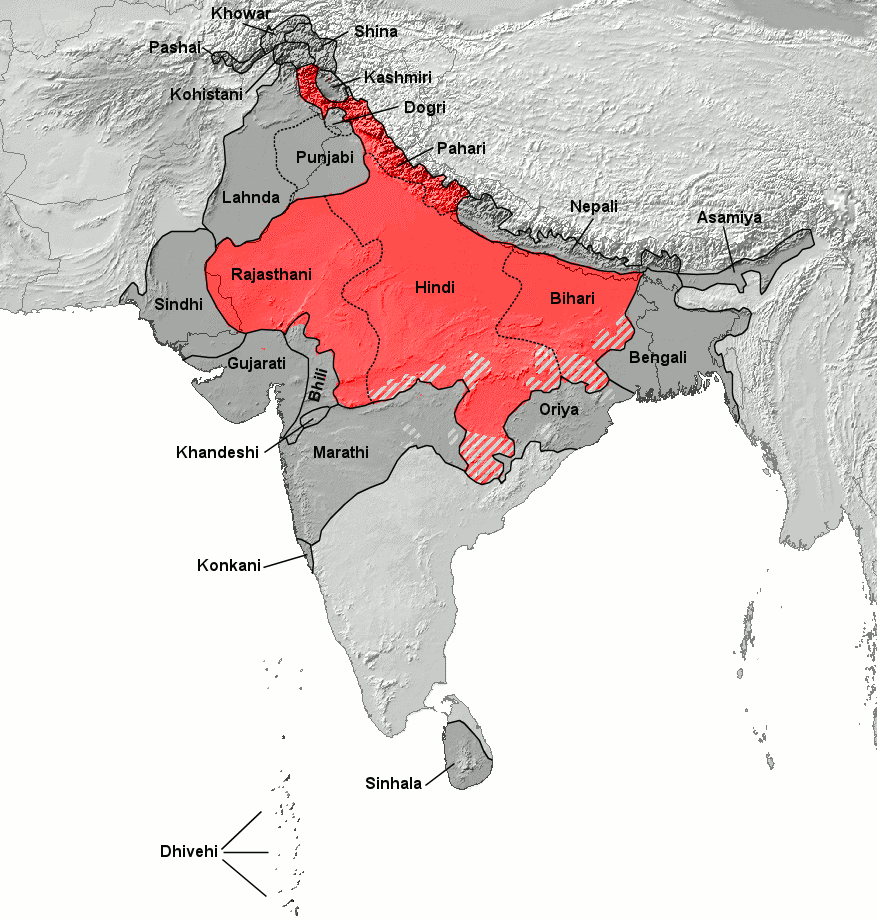
Hindi (हिन्दी hindī /ɦind̪iː/) ist eine indoarische, damit zugleich indoiranische und indogermanische Sprache, die in den meisten nord- und zentralindischen Staaten gesprochen wird und sich von den Prakritsprachen ableitet. Seit 1950 ist es (neben Englisch) die Amtssprache Indiens. Hindi ist eng mit Urdu verwandt.
Unter den meistgesprochenen Sprachen der Welt steht Hindi an dritter Stelle nach Chinesisch und Englisch, noch vor Spanisch. Über 600 Millionen Menschen in Indien und Umgebung gebrauchen es als Mutter- oder Alltagssprache. In Fidschi spricht mehr als ein Drittel der Bevölkerung Fidschi-Hindi, in Guyana und Suriname eine Minderheit, wobei es vor allem in Guyana rasch an Sprechern verliert (das surinamische Hindi wird gelegentlich als Einzelsprache betrachtet).
Hindi wird in Devanagari geschrieben und enthält viele Buchwörter aus dem Sanskrit. Dagegen wird Urdu, als offizielle Sprache Pakistans, mit arabischen Schriftzeichen geschrieben und hat viele Wörter der persischen, türkischen und arabischen Sprache aufgenommen. Beides sind Varietäten des Hindustani.
Die Verwendung von Wörtern unterschiedlicher Herkunft war lange Gegenstand nationaler politischer Bestrebungen. Hindu-Nationalisten ersetzen systematisch Wörter arabischer Herkunft durch Entlehnungen aus dem Sanskrit, um damit ihre kulturelle Eigenständigkeit zu betonen. Ähnliche Bestrebungen zur Förderung von Sanskrit gab es in Form des Popular Sanskrit. Außerdem gibt es eine Vielzahl lokaler Dialekte des Hindi.
印地语(天城文:हिन्दी或हिंदी,拉丁字母转写:Hindī),又译为北印度语、印度语[來源請求][註 2],是印欧语系印度-伊朗语族中印度-雅利安语支下的一种语言。以使用国家来算,印地语是世界排名第八的语言,在1965年1月26日成为印度中央政府的官方语言之一(连同英语)。印地语和乌尔都语(并称印度斯坦语)大同小异,主要区别在于前者用天城文,后者用基于阿拉伯字母的乌尔都字母,前者引进的梵语借词多一点,后者的阿拉伯语和波斯语借词多一些。
标准印地语基于在语言学界称为俱卢口语(天城体梵文:कौरवी Kauravī,意思是“俱卢+呾提多后缀a+所有格”[10])的德里及其近郊口语[11]发展而来。俱卢口语在印度通称“卡里口语”或“标准口语”。
英国统治印度之前,印度敎徒多使用弥梯罗语、摩揭陀语、西弗栗恃语等东部语言,高度波斯化的俱卢口语位格不高。[12]然而,多次虔敬派运动逐降低了印度教徒及其语言的地位[13],最终尽管俱卢口语在印度被英国殖民之前毫无任何文学性可言(当时德里的官方语言是波斯语)[13],其仍然异军突起成为英国殖民时期摩陀耶提舍平原的通用语,今天印地语的分布范围和使用人口远超过其前身俱卢族口语,已成为全体摩陀耶提舍人各个族群进行族际交流的第二语言,在摩陀耶提舍的通用程度超过英语。
印地语和乌尔都语加起来是世界上第二大语言,使用人口超过5亿人,仅次于汉语。2020年的调查发现,40%的印度人会说印地语。根据2001年调查数据,仅在印度就有4亿2,200万左右的人把印地语当作母语,此外有超过5,000万人的母语为“乌尔都语”[14],另外3亿人将印地语当第二语言使用。
 Art
Art
 World Heritage


 Military, defense and equipment


 Aerospace

Hindustan Aeronautics Limited (HAL) ist eines der wichtigsten Luft- und Raumfahrtunternehmen des indischen Verteidigungsministeriums. Sein Sitz befindet sich in der indischen Stadt Bengaluru. Die Hauptbereiche des Unternehmens liegen in der Herstellung von Flugzeugen, Luft- und Raumfahrttechnik sowie Kommunikations- und Navigationsausrüstung.
印度斯坦航空有限公司(印地语:हिंदुस्तान एरोनॉटिक्स लिमिटेड、英语:Hindustan Aeronautics Limited)是印度一家国有的航空、航天和国防公司,总部设于印度的班加罗尔,由印度国防部管辖。
 Energy resource