
Deutsch-Chinesische Enzyklopädie, 德汉百科
 China
China
 History


唐三彩是唐代盛行的一种釉陶,距今已有1000多年的历史。所谓唐三彩,是指唐代陶器上的釉色,后来也用来泛称唐代彩陶。唐代彩陶的釉色有很多种,如浅黄、赭黄、浅绿、深绿、天蓝、褐红、茄紫等,但主要以黄、绿、褐(或绿、赭、蓝)三色为主,所以称之为“三彩”。
唐三彩不见于古代文献,直到清末建造隴海鐵路,在洛阳邙山毁损唐代墓葬,發現颇多的唐三彩陶器。古董商将其运至北京,引起学者王国维、罗振玉等的高度重视,出土的唐三彩被修復成功,引發了收藏熱[1]。
唐三彩采用二次烧成法。首先使用白色粘土作胎,在窑内经过1000℃-1100℃的素烧,经过冷却,再于胎上绘以各种釉料入窑进行釉烧。唐三彩是一种低温(850℃-950℃)釉陶器,用含有铜(釉为绿色)、铁(赭黄色)、锰(紫色)、钴(蓝色)、锑(浅黄)等作釉料着色剂,并加入铅、铝作助熔剂。其釉色互相渗化,加上年代久远,部分颜色发生变化并产生新色,具有较高的装饰艺术水平。但由于实用性较差,唐三彩主要用于随葬,即冥器和俑。
唐三彩种类很多,主要分为人物、动物和器物三种。人物有文臣、武将、贵妇、男僮、女仆、艺人、胡人等。动物有马、骆驼、牛、羊、狮、虎等。器物有盛器、文房用具、室内用具等。古时,唐三彩很少用作日用品和陈设品,大部分用作随葬品,主要出产、流行于中原地区,供这一带的大小官僚们使用。随着唐朝陵墓的发掘,大量随葬品唐三彩得以面世。随葬品唐三彩主要分为器物类,如碗、壶、盘、房屋等;以及俑像类,如仕女、文吏、胡人、乐伎、武士、天王、马、骆驼等。
Sancai (Chinese: 三彩; pinyin: sāncǎi; literally: "three colours")[1] is a versatile type of decoration on Chinese pottery using glazes or slip, predominantly in the three colours of brown (or amber), green, and a creamy off-white. It is particularly associated with the Tang Dynasty (618–907) and its tomb figures,[2] appearing around 700.[3] Therefore, it is commonly referred to as Chinese: 唐三彩 Tang Sancai in Chinese. Tang sancai wares were sometimes referred in China and the West as egg-and-spinach by dealers, for their use of green, yellow, and white, especially when combined with a streaked effect.[4]
It uses lead-glazed earthenware, and although two firings were needed,[5] it was easier and therefore cheaper to make than Chinese porcelain or celadon, and suitable for making large figures, if necessary made up of several moulded sections assembled after a first firing. Vessels, mostly rather small and made for burial, were made in the technique as well as figures. Small plates with three feet, typically about 18-40 cm (7-16 inches) across, called "offering-trays", are a distinctive type, with more carefully controlled decoration than other types of pieces.[6]
The white may come from the natural colour of the fired clay, sometimes coated with a transparent glaze, or there may be a white slip. The brown and green colours came from adding metal oxides to a lead glaze, and in fact blues and blacks are also found. The blue came from adding imported cobalt, and was therefore more expensive and used sparingly, often on smaller pieces.[7]
唐三彩(とうさんさい、拼音: 、三彩とも)は唐代の鉛釉を施した陶器で、主として副葬用に制作された。いわゆる唐三彩は唐代の陶器の上の釉薬の色を指し、後に唐代の彩陶(上絵を施した陶器)を総称する語として使われるようになった。唐代の陶器の釉薬の色は非常に多く、クリーム色、赤褐色、薄緑、深緑、藍色、紫などがある。中でもクリーム色・緑・白の三色の組み合わせ、或いは緑・赤褐色・藍の三色の組み合わせを主としていることから三彩と称されている。
唐三彩は成形後二回にわたって焼かれる。一回目は白色の粘土で器物の原型を作り、窯の中で1000~1100度で素焼きにされる。冷却の後、器物を取り出し、各種の釉薬をかけ、再び窯の中で850~950度で焼かれる。炎色反応を用いて色を付けることから、釉薬には銅(緑)、鉄(赤褐色)、マンガン(紫色)、コバルト(藍色)、アンチモン(クリーム色)を用い、助燃剤として鉛やアルミニウムを用いる。釉薬の色が互いに浸透し、年代が経つことにより、顔料の色が微妙に変化し、新たな色を作る。 この釉薬は鉛釉と呼ばれ、漢代に西域から伝播した技術とも言われている。鉛釉の特徴は、釉層中の気泡の少なさからくる透明度と光沢の強さにある。施釉技法は刷毛や筆、柄杓掛け、浸し掛けなどが基本となる。
唐三彩の形状は非常に多く、人物、動物、器物の三種に主に分類される。人物には天子、文官、武将、貴婦人、男の子、下女、芸人、ペルシア人などがある。動物には、馬、ラクダ、牛、羊、ライオン、虎などがある。器物には容器、文房具、お碗、壺、皿などがある。 日用品や部屋の装飾品よりも主に埋葬品として使用され、主に中原一帯で生産・流行し、中原一帯の官僚たちに使用された。『唐六典』には葬儀における唐三彩の規定が記されており、『旧唐書』には当時の唐三彩熱を伺わせる文章がある。
Le terme sancai (chinois : 三彩 ; pinyin : ; littéralement : « trois couleurs ») désigne un type de céramique chinoise dont les décorations comportent des glaçures polychrome de trois couleurs, ou davantage.
La technique de la céramique sancai remonte à la dynastie Tang. En dépit du nom, le nombre de glaçures de couleurs différentes réellement utilisées pour les sancai, les céramiques « trois couleurs », pouvait s'élever à une douzaine, sur certaines pièces très élaborées.
Les céramiques sancai étaient fabriquées au nord de la Chine, en utilisant du kaolin et de l'argile réfractaire1, et contenant très peu de fer ; le corps de l'objet était ensuite recouvert d'un engobe blanc, sur lequel le potier posait les glaçures. Celles-ci étaient souvent juxtaposées, et, du fait de leur fluidité assez élevée, avaient tendance à couler et à se mêler, produisant à la surface des l'objet des coulures et des taches colorées2.
Les glaçures colorées avaient les origines suivantes : Le jaune provenait de l'oxyde de fer (cuit en oxydation), le vert venait de l'oxyde de cuivre, le violet du manganèse. Mais les Tang introduisirent une nouvelle et importante couleur, le bleu, obtenu à partir de l'oxyde de cobalt qu'ils importaient du Moyen-Orient (sans doute de Perse) par les nouvelles routes commerciales qu'ils avaient ouvertes au travers de l'Asie centrale.
Le biscuit sancai était tout d'abord cuit sans glaçure, à 900°C. Puis on rajoutait les glaçures, pour cuire la poterie aux alentours de 1 000°C3.
À Yaozhou, province du Hebei, et à Gongyi dans le Henan1, les argiles utilisées pour les statuettes funéraires étaient similaires à celles utilisées par les potiers Tang. Ces statuettes étaient cuites à une température inférieure à la porcelaine d'aujourd'hui ; ces statuettes funéraires, comme les représentations bien connues de chameaux et de chevaux, étaient moulées en plusieurs parties (corps et tête séparés) que l'on assemblait par une barbotine. Pour les pièces les plus élaborées, la statuette était personnalisée en retouchant la pièce à la main.
Il termine sancai (cinese: 三彩S, sāncǎiP, letteralmente "tre colori") designa un tipo di ceramica cinese le cui decorazioni comportano vetrine policrome di tre colori, o più.
La tecnica della ceramica sancai risale alla dinastia Tang. A dispetto del nome, il numero di vetrine di colori diversi realmente utilizzati per i sancai, le ceramiche «tre colori», poteva aumentare a una dozzina, su certi pezzi molto elaborati.
Le ceramiche sancai erano fabbricate nel nord della Cina, usando caolino e argilla refrattaria[1], e contenente pochissimo ferro; il corpo dell'oggetto era poi ricoperto da un ingobbio bianco, sul quale il vasaio posava le vetrine. Queste erano spesso giustapposte e, a causa dello loro fluidità abbastanza elevata, avevano la tendenza a fondere e a mescolarsi, producendo sulla superficie dell'oggetto colature e chiazze colorate[2].
Le vetrine colorate avevano le seguenti origini: il giallo proveniva dall'ossido di ferro (cotto in ossidazione), il verde veniva dall'ossido di rame, il viola dal manganese. Ma i Tang introdussero un nuovo e importante colore, il blu, ottenuto a partire dall'ossido di cobalto che importavano dal Medio Oriente (senza dubbio dalla Persia) lungo le nuove rotte commerciali che avevano aperto attraverso l'Asia centrale.
Il biscotto sancai era innanzitutto cotto senza vetrina, a 900°C. Poi si aggiungevano le vetrine, per cuocere la ceramica intorno a 1 000°C[3].
A Yaozhou, provincia dell'Hebei, e a Gongyi nell'Henan[1], le argille usate per le statuette funerarie erano simili a quelle utilizzate dai vasai Tang. Queste statuette erano cotte a una temperatura inferiore alla porcellana di oggigiorno; queste statuette funerarie, come le rappresentazioni ben conosciute di cammelli e di cavalli, erano modellati in varie parti (corpo e testa separati) che si assemblavano mediante una barbottina. Per i pezzi più elaborati, la statuetta era personalizzata ritoccando il pezzo a mano.
Sancai (chino:三彩; literalmente=tres colores) es un tipo de cerámica que utiliza como decoración tres colores entremezclados.
El cuerpo de la cerámica sancai era fabricado con arcilla blanca, pintada con una capa de vidrio, y cocida a temperaturas de unos 800 grados Celsius. Sancai es un tipo de cerámica vidriada con plomo: el óxido de plomo era el principal fundente en el vidriado, a menudo mezclado con cuarzo en una proporción de 3:1.1 El efecto policromado a menudo era obtenido utilizando como agentes colorantes cobre (que se torna verde), hierro (el cual toma un tono marrón amarillento), y en forma menos frecuente manganeso y cobalto (el cual se vuelve azul).1
El sancai se basa en el desarrollo de la cerámica vidriada verde que se remonta al período Han (25-220).1
Los predecesores del estilo sancai también pueden ser observados en algunos trabajos en cerámica de Qi del norte (550-577). Las tumbas Northern Qi han permitido el hallazgo de hermosas piezas, tales como elementos de porcelana con diseños en tonos de verde, que antes se consideraba habían sido realizados durante la dinastía Tang.2 Una jarra con estas características fue encontrada en una tumba de Northern Qi, que se remonta al 576 CE, y es considerada una precursora del estilo de cerámica sancai Tang.3
Сань-цай[1][2] (кит. упр. 三彩, пиньинь: sāncǎi; дословно: «три цвета») — тип керамики, в котором для украшения используется три цвета. В русскоязычных текстах также встречается неграмотное написание «санкай»[3]
Техника сань-цай восходит к эпохе династии Тан. Однако, несмотря на название, количество цветов глазури для украшения изделий той эпохи обычно не ограничивалось тремя. Торговцы на Западе иногда называли изделия сань-цай эпохи Тан «яйцом со шпинатом», за использование в них зелёного, жёлтого и белого цветов (хотя последний цвет более точно можно назвать «янтарным», «не совсем белым» или «кремовым»).
Изделия сань-цай делали в северном Китае, где для изготовления керамики использовался белый каолин и обожжённый тёмно-жёлтый вторичный каолин, а также огнеупорная глина[4] В этом сырье содержится очень мало железа. Изделия перед обжигом покрывали белой глиной и наносили глазурь. Из-за высокой пластичности материала на изделии образовывались переплетающиеся подтёки, которые создавали на поверхности цветные пятна и полосы.
В печах, расположенных в Тунчуане, округе Нэйцюи провинции Хэбэй и в Гунсяне (провинция Хэнань)[4], глина, использовавшаяся для ритуальных изделий, была похожа на ту, которую использовали гончары эпохи империи Тан. Ритуальные изделия изготовляли при более низкой температуре, чем белый фарфор той эпохи. В некоторых случаях фигуркам в наборе придавали индивидуальность с помощью ручной гравировки.
 Geography

 Architecture
 Religion

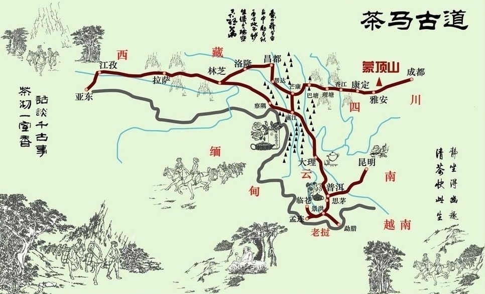
茶馬古道(ちゃばこどう)とは雲南省で取れた茶(磚茶)をチベットへ人および馬で運んだことから名付けられた交易路である。南のシルクロード(Southern Silk Road)とも。7世紀の唐や吐蕃の時代にはすでに交易が始められ、20世紀中ごろが流通の絶頂期と言われていて、毛沢東が自動車道を雲南に作るまでこの茶馬古道は使われていた。
雲南省南部の易武が起点。途中、景洪市やプーアル、那柯里などのメコン川沿いで寝泊まりしながら雲南省を北上し、虎街では町の真ん中を茶馬古道が通っている。その後、雲南の最初の王国・南詔国の都・巍山から大理を経由し、麗江市からは長江沿いを行き、ガダン・ソンザンリン寺院などを経由しながら雲南を出る。
チベット 、ミャンマー 、ネパール 、インド などへ抜ける幾つかのコースがある。四川省を起点とするコースも含める[1]。
主な交易品は雲南地域より塩、茶、銀製品、食料品、布製品、日用品など。チベット地域より毛織物、薬草、毛皮など。チベットを経由してインド・ネパールで生産されたの物資も雲南に届いたと言う。茶馬古道の要衝といわれる有名な都市にラサ、徳欽、迪慶、昌都(Qamdo)、芒康(Mar-kham)、麗江、大理、思茅などがある。
The Tea Horse Road or chamadao (simplified Chinese: 茶马道; traditional Chinese: 茶馬道), now generally referred to as the Ancient Tea Horse Road or chamagudao (simplified Chinese: 茶马古道; traditional Chinese: 茶馬古道) was a network of caravan paths winding through the mountains of Sichuan, Yunnan and Tibet in Southwest China.[1] This was also a tea trade route. It is also sometimes referred to as the Southern Silk Road or Southwest Silk Road, and it is part of a complex routes system connecting China and South Asia.
There are numerous surviving archaeological and monumental elements, including trails, bridges, way stations, market towns, palaces, staging posts, shrines and temples along the route. Besides the route's importance for commercial activity, more significantly it was crucial for cultural exchange between the Indian subcontinent, Tibet and Southwest China. Especially, it was vitally important for the interchange of Buddhism between China and South Asia.[2]
La route du thé et des chevaux ou l'ancienne route du thé et des chevaux (en chinois : 茶马古道, Cha ma gu dao), est un réseau de sentiers muletiers serpentant en zone montagneuse à partir du Sichuan et du Yunnan en Chine, pour gagner respectivement vers l'ouest et le nord-ouest le Tibet central et vers le sud-ouest la Birmanie. Des caravanes de chevaux, mulets, yaks et porteurs humains transportaient sur 2 400 à 2 600 km, des briques ou des galettes de thé, pour les troquer au Tibet contre des fourrures, vêtements de laine, musc et matières médicinales. La référence aux chevaux, vient du fait qu'entre le XIe siècle et le XVIIIe siècle, l'administration chinoise imposa aux populations périphériques du nord-ouest un système de troc étatique de thé contre des chevaux de guerre, nécessaires à la cavalerie impériale. Ce système commercial fonctionna tant bien que mal suivant les époques mais sans emprunter forcément les sentiers muletiers dits chama gudao. C'est d'ailleurs pourquoi ce réseau muletier est aussi appelé xinan sichou zhilu (西南丝绸之路, « « route de la soie du sud-ouest », car des soieries y étaient parfois échangées contre les chevaux.
Les échanges commerciaux entre les grands centres dynamiques de la culture chinoise et les peuples tibétains, divisés mais à l'identité culturelle bien marquée, n'ont cessé de se développer et de se diversifier au cours du dernier millénaire grâce à ces pistes caravanières. Les petits sentiers muletiers du début sont devenus au fil du développement des pistes caravanières de plus en plus larges, pour devenir à la fin du XXe siècle de grandes routes nationales carrossables, reliant toujours deux entités jusqu'alors inégalement développées mais finalement politiquement intégrées à la Chine, après des siècles de vassalisation plus ou moins variable, principalement pas les Mongols et les Mandchous, depuis la dynastie Yuan (1234/1279 – 1368).
L'antica via del tè , o antica via del tè e dei cavalli (cinese: 茶马古道|), era una rete di percorsi per carovane di muli che aggirava le montagne della provincia dello Yunnan, nella Cina sud-occidentale. Viene chiamata anche via della seta meridionale. Circa mille anni fa, l'antica via del tè era un rotta commerciale che univa lo Yunnan, uno dei maggiori produttori di tè, all'India, passando per Birmania e il Tibet, e alla Cina centrale passando per la provincia del Sichuan. Oltre al tè, le carovane di muli trasportavano sale.
Si crede che fosse grazie a questa rotta che il tè si diffuse in Cina ed Asia.
Древний чайный конный путь (кит. трад. 茶馬古道, упр. 茶马古道, пиньинь chámǎgǔdào, палл. чамагудао) — название комплекса торговых путей, на протяжении столетий связывавших Китай с Южной Азией.
Argentina
China
 Eat and Drink
 *Types of tea, Tea growing areas, Tea ceremony, Tea culture
India
Indonesia
Iran
Japan
Kenya
Sri Lanka
Turkey
Vietnam
*Types of tea, Tea growing areas, Tea ceremony, Tea culture
India
Indonesia
Iran
Japan
Kenya
Sri Lanka
Turkey
Vietnam
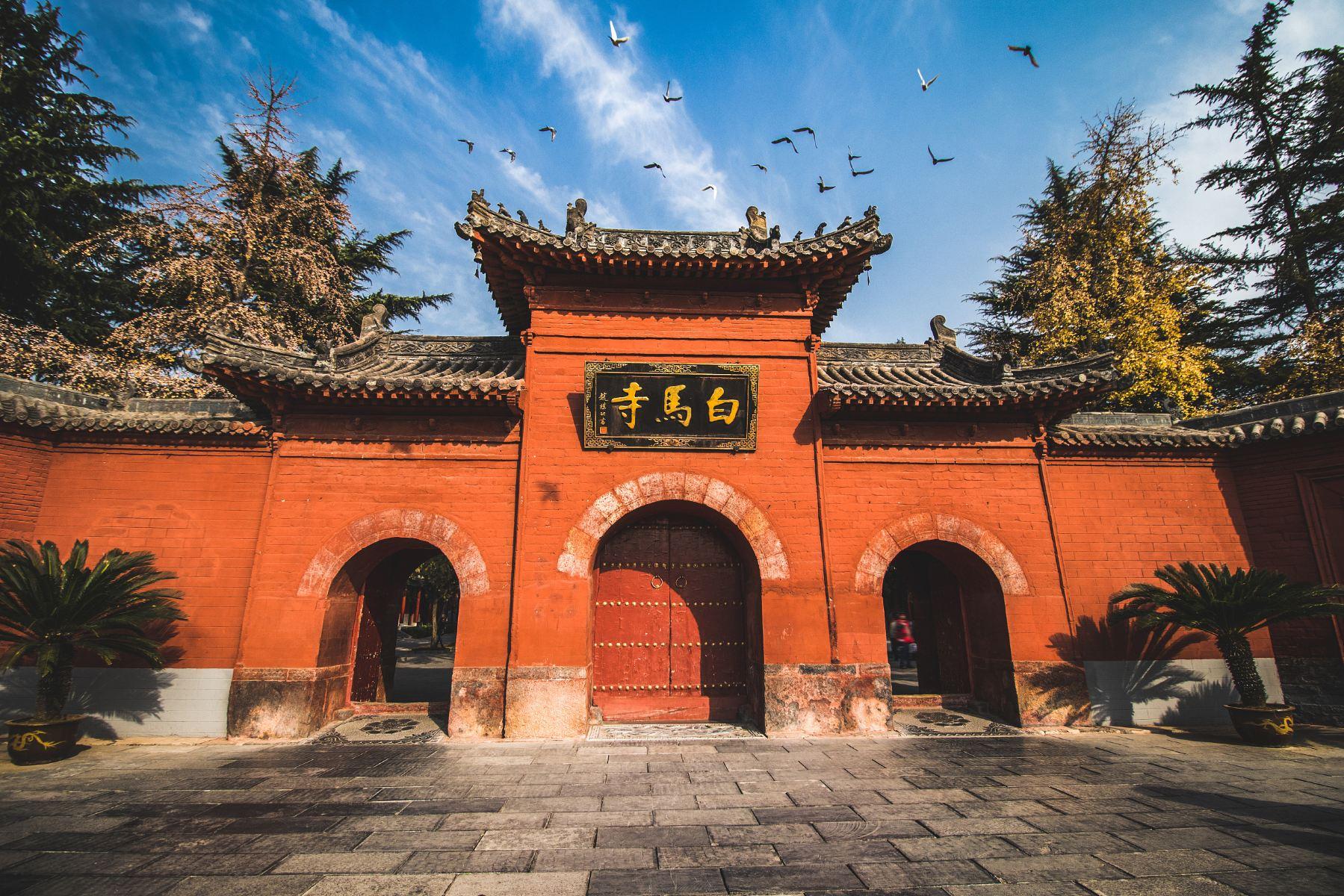


白马寺的营建与中国历史上的“永平求法”紧密相连。东汉明帝曾夜梦丈六金人,顶佩白光,自西方飞来。大臣傅毅认为这是西方的佛,汉明帝遂“感梦求法”,令蔡愔、秦景、王遵等十余人于永平七年(64年)赴天竺(古代印度)求佛法。[3]他们在西域的大月氏(古代阿富汗)遇到了来自天竺的僧人摄摩腾和竺法兰,得佛经佛像,于是相偕同行,以白马驮经,并于永平十年(67年)来到当时的京城雒阳。为了给两位高僧一个居住和翻譯《四十二章經》的地方,汉明帝敕命在城西的雍门外按天竺式样建造了一组建筑,以僧人们暂住的“鸿胪寺”的“寺”字称之,为了纪念白马驮经之功,便将这组建筑命名为“白马寺”。
Das Kloster des weißen Pferdes liegt circa 12 Kilometer östlich der heutigen Stadt Luoyang in der Provinz Henan und soll angeblich im Jahre 68 gegründet worden sein.
Sein Name geht auf die folgende Legende zurück, die im "Buch über die Späte Han Dynastie" enthalten ist, das im 5. Jahrhundert kompiliert wurde.
Der Kaiser Ming aus der Östlichen Han Dynastie träumte im Jahre 64 von einer goldenen Gestalt, die über seinem Palast schwebte. Seine Minister erklärten ihm, daß er vom Buddha in Indien geträumt habe. Der Kaiser sandte daraufhin eine 18-köpfige Delegation nach Indien, die dort den Buddhismus studieren sollte. Nach drei Jahren kehrte die Delegation aus der Gegend des heutigen Afghanistan, wo sie die beiden indischen Mönchen Kashyapamtanga und Dharmaraksha getroffen hatte, zurück. Mit ihnen kam ein weißes Pferd, das ein Bündel voller buddhistischer Sutren und Figuren trug. Im folgenden Jahr ließ dann der Kaiser den Tempel für die Mönche und zur Erinnerung an die Ankunft des weißen Pferdes bauen. (Quelle:http://www.china-entdecken.com/LandundLeute/Louyang-Baima%20Si.htm)
迦葉摩騰と竺法蘭の二人の僧が、白馬に乗り『四十二章経』という経典を携えて、都の洛陽を訪れたという説話に因んで、白馬寺と名づけられた。[1]
『洛陽伽藍記』巻4によると、北魏時代には後漢の明帝が建立した寺として、洛陽城の城西、西陽門外3里の地点にあったと記される。北魏の頃には、寺に安置された経函が放光し、その経函に対する信仰があったことが記される。ただし、その経函中に収められた経典が『四十二章経』であるとは明記されていない。
White Horse Temple (Chinese: 白马寺) is Buddhist temple in Luoyang, Henan that, according to tradition, is the first Buddhist temple in China, having been first established in 68 AD under the patronage of Emperor Ming in the Eastern Han dynasty.[1][2][3]
The site is just outside the walls of the ancient Eastern Han capital, some 12–13 kilometres (7.5–8.1 mi) east of Luoyang in Henan Province. It is approximately 40 minutes by bus No. 56 from Luoyang railway station.[4] The temple, although small in comparison to many others in China, is considered by most believers as "the cradle of Chinese Buddhism".[5] The geographical landmarks to the south are Manghan mountain and Lucoche River.[6]
The main temple buildings, a large complex, were reconstructed during the Ming (1368 to 1644) and Qing (1644 to 1912) dynasties.[7] They were refurbished in the 1950s, and again in March 1973 after the Cultural Revolution. It has numerous halls divided by courtyards and manicured gardens, covering an area of about 13 hectares (32 acres). The display plaques in Chinese and English give ample descriptions of the Buddhist deities installed in the halls. Significant statues include Śākyamuni Buddha, Maitreya (the laughing Buddha in China), the Jade Buddha, figures of saints such as Guru Avalokiteśvara, Amitābha and arhats and stone statues of the two white horses which brought the Indian monks to China and two mythical lions at the entrance.[1][2][3] Under international funding, the temple has undergone many changes, both structurally and internally. The most recent cooperative project, with India, was completed in 2008 when the Sanchi Stupa and the Sarnath Buddha statue were erected.
Le temple du Cheval blanc (chinois simplifié : 白马寺 ; chinois traditionnel : 白馬寺 ; pinyin : ) de Luoyang, province du Henan, en République populaire de Chine, est un complexe monastique bouddhique situé dans la banlieue est de la ville moderne, à l’emplacement où, selon la tradition, s’arrêta en 67 ap. J.-C. le cheval portant depuis l’Afghanistan les premiers soutras. Les constructions et objets qu’il renferme datent essentiellement de la période allant des Jin au milieu des Qing (XIIe-XVIIIe siècles) et comprennent en particulier un ensemble de statues de laque de l’époque Yuan (1271-1368). Il fait partie depuis 1961 du patrimoine culturel protégé1.
D’autres temples portèrent ou portent encore le même nom. Certains font directement référence au Baimasi de Luoyang, d’autres ont pu être nommés indépendamment2.
Il monastero del Cavallo Bianco (白馬寺T, 白马寺S, Báimǎ-sìP) è, secondo la tradizione, il primo tempio buddhista della Cina, fondato nel 68 d.C. sotto l'imperatore Ming (r. 58-75 d.C.) degli Han Orientali, situato nella capitale Luoyang.[1][2][3]
Il monastero si trova appena al di fuori delle mura dell'antica capitale degli Han Orientali, distante circa 12-13 km a est dall'attuale Luoyang, provincia dello Henan. Dista approssimativamente 40 min coll'autobus no. 56 dalla stazione ferroviaria di Luoyang.[4] Il tempio, nonostante le sue ridotte dimensioni, è considerato da molti fedeli come "la culla del buddhismo cinese".[5] I punti di riferimento geografici sono, partendo da sud, il monte Manghan e il fiume Luo.[6]
Le principali costruzioni del monastero furono erette durante le dinastie Ming (1368-1644) e Qing (1644-1912);[7] vennero ristrutturate negli anni 1950, e poi nel marzo del 1973 dopo la Rivoluzione Culturale. È costituito da numerose sale separate da cortili e giardini ben curati, coprendo un'area di 13 ettari. Le placche in cinese e in inglese danno una ricca descrizione delle statue buddhiste situate in ogni sala; esse raffigurano, tra gli altri, Śākyamuni, Maitreya, il Buddha di Giada, icone di santi come Guru Avalokiteśvara, Amitābha, arhat, due cavalli bianchi portati dall'India da due monaci indiani, e due leoni mitici all'entrata.[1][2][3] Per via dei finanziamenti internazionali, il tempio ha subito numerosi cambiamenti, sia strutturalmente che internamente. Il progetto più recente, realizzato colla cooperazione dell'India, è stato terminato nel 2008 col completamento dello stupa di Sanchi e della statua del Buddha di Sarnath.
El Templo del Caballo Blanco (en chino: 白马寺, pinyin: Báimǎsì) es el primer templo del Budismo en la República Popular de China, establecido en el año 68, bajo el patrocinio del Emperador Ming de Han de la Dinastía Han Oriental en Luoyang.
Hoy en día el sitio está ubicado a las afueras de las murallas de la antigua capital de Han del Este, algunos 12 a 13 kilómetros al este de Luoyang en la provincia de Henan. Se encuentra aproximadamente a 40 minutos en autobús desde la estación del tren de Luoyang. El templo, aunque es pequeño en comparación con muchos otros templos de China, es considerado por la mayoría de los creyentes como "la cuna del budismo chino".
Баймасы (Храм Белой Лошади, кит. трад. 白馬寺, упр. 白马寺, пиньинь: Báimǎ Sì) — первый буддийский храм Китая. Основан при покровительстве ханьского императора Мин-ди в столичном городе Лоян в 68 г. н. э.
По сообщению «Хоу Ханьшу», поводом к основанию храма стал приснившийся императору сон о прибывшем с запада исполинском божестве, от которого исходил свет.[1] Решив по совету сановников, что речь идёт о Будде, император снарядил посольство в Индию, которое вернулось в Лоян со статуей Гаутамы и «Сутрой из 42 глав».[1]
По возвращении посольства император распорядился основать буддийский храм, первым настоятелем которого стал приехавший буддийский монах Кашьяпа Матанга.[1] Своё название он получил от белой лошади, на которой в Китай прибыли буддийские святыни.[2][3] Храм многократно перестраивался. Храмовые строения раскинулись на территории 13 гектаров в 12 км к востоку от современного города Лоян.[4]

滕王阁,江南三大名楼之一。位于中国江西省南昌市赣江畔。屡毁屡建,今日之滕王阁为1989年重建。
Der Tengwangge-Pavillon befindet sich im Norden der Stadt, am Zusammenfluss vom Ganjiang und Fuhe. Der Bau des Pavillons wurde während der Tang-Dynastie im Jahre 653 von Prinz Li Yuanying in Auftrag gegeben. Über viele Jahrhunderte hinweg galt das Gebäude als der Höhepunkt der Pavillon-Architektur in China. Vom 9-stöckigen, mehr als 57 Meter hohen Pavillon hat man eine perfekte Aussicht auf die Stadt Nanchang und die beiden Ströme Ganjiang und Fuhe. In den vergangenen fast anderthalb Jahrtausenden wurde das Gebäude mehr als 20 Mal in Folge durch Kriege oder Unwetter zerstört und ist immer wieder neu errichtet und ausgebaut worden. Die letzte Renovierung war vor 13 Jahren. Vor Jahrhunderten war der Pavillon ein häufiger Treffpunkt für Fürsten, Mandarine und auch Literaten. Besonders in der Abenddämmerung im Herbst bietet sich den Besuchern des Pavillons ein idyllisches Bild. Ein Dichter aus der Tang-Dynastie namens Wang Bo schilderte einmal die Szenerie, die ihn bezauberte: "In der Herbstabenddämmerung wirft man einen Blick aus der Höhe des Gebäudes hinaus in die Ferne, und es lässt sich kaum erahnen, wo der Horizont den Fluss vom Himmel scheidet. Erst die Wildenten, die dort in der Ferne himmelwärts ziehen, lösen das Bild auf".
Diese poetische Beschreibung von Wang Bo wurde berühmt und hat auch den Tengwangge-Pavillon bekannt gemacht. Der Pavillon zieht seither alle an, die auf den Spuren des Dichters jene Szenerie nachempfinden wollen, die ihn so tief beeindruckt hatte.(Quelle: www.chinareisedienst.de)
唐代の653年(永徽四年)、当時この地に封じられた李元嬰(唐の建国者・李淵の第22子)の道楽によって建てられた。彼は最初は滕県(現在の山東省滕州市)に封じられていたため滕王と呼ばれており、ここから滕王閣と呼ばれる。幾度も戦乱などにより破壊された。清の同治年間に28回目の再建が行われたが1929年に軍閥同士の戦争で破壊され再建されていなかった。現在のものは1989年に再建されたもので29回目の再建に当たる。
贛江のほとりに建てられており、楼閣から街を見下ろすことができる。
The Pavilion of Prince Teng (Chinese: 滕王阁; pinyin: Téngwáng gé) is a building in the north west of the city of Nanchang, in Jiangxi province, China, on the east bank of the Gan River and is one of the Three Great Towers of southern China. The other two are the Yueyang Tower and the Yellow Crane Pavilion. It has been destroyed and rebuilt many times over its history. The present building was rebuilt in 1989 on the original site. The rebuilding plan was devised by the architect Liang Sicheng, and now the Pavilion of Prince Teng is the landmark of Nanchang. There are nine floors in total. The main architectural structure is in Song dynasty wooden style, showing the magnificence of the Pavilion.
The Pavilion of Prince Teng was first built in 653 AD, by Li Yuanying, the younger brother of Emperor Taizong of Tang and uncle of Emperor Gaozong of Tang. Li Yuanying was enfeoffed as Prince Teng in 639 and spent his early years in Suzhou. In 652 he was assigned the governorship of Nanchang where the pavilion served as his townhouse. The Pavilion of Prince Teng is the only existing royal architecture in southern China. Twenty years later, the building was rebuilt by the new governor. Upon its completion, a group of local intelligentsia gathered to compose prose and poetry about the building. The most famous of these is the Preface to the Pavilion of Prince Teng by Wang Bo. This piece made the Pavilion of Prince Teng a household name in China down to the present day.
The Pavilion was to be destroyed and rebuilt a total of 29 times over the next centuries.[1] The building itself changed shape and function many times. The penultimate construction was during the Tongzhi era of the Qing Dynasty. That building was destroyed in October 1926 during the chaotic warlords era.[2]
Le Pavillon du Prince Teng (chinois simplifié : 滕王阁 ; chinois traditionnel : 滕王閣 ; pinyin : ) se situe sur la rive est de la rivière Gan dans la ville de Nanchang dans la province de Jiangxi en Chine. L'édifice a été au fil du temps plusieurs fois détruit par des incendies puis reconstruit.
Le pavillon est bâti en 653 par Li Yuanying, frère cadet de l'empereur Tang Taizong. Li Yuanjing est intronisé Prince Teng en 639 et passe son enfance à Suzhou. Une vingtaine d'années après l'achèvement de la construction, le poète Wang Bo écrit un célèbre poème intitulé Préface au pavillon du Prince Teng.
China
 Art
*China's ceramics and porcelain
Shaanxi Sheng-SN
Emperor Qin Terracotta Warriors and Horses Museum
Art
*China's ceramics and porcelain
Shaanxi Sheng-SN
Emperor Qin Terracotta Warriors and Horses Museum
 World Heritage
 Civilization

Die Terrakotta-Armee nahe der chinesischen Stadt Xi'an wurde in Jahre 1974 während einer Brunnenbohrung im Dorf Xijang, in der Provinz Shaanxi, gefunden. Wenige Tage später bereits, begann ein chinesisches Archäologen-Team damit, die Sensation freizulegen. In mehrjähriger Arbeit wurden nach und nach viele tausend der lebensgroßen Terrakotta-Figuren freigelegt. Heute ist die Terrakotta-Armee Teil des UNESCO-Weltkulturerbes und eines der beeindruckendsten und wertvollsten Zeugnisse der frühen chinesischen Geschichte.
Auf chinesisch wird die Terrakotta-Armee "Soldaten- und Pferdefiguren" genannt, denn das sind die beiden Hauptmotive des gigantischen Kunstwerks. Die Armee aus Terrakotta-Figuren bewacht den Grabhügel des ersten gesamtchinesischen Kaisers Qin Shi Huang. Mehr Informationen über die geschichtlichen Hintergründe finden Sie in unserem China-Lexikon zum Thema Terrakotta-Armee von Xian.
China
Denmark
Netherlands
 Ships and Nautics
Sweden
Spain
Ships and Nautics
Sweden
Spain
 Sport
The Ocean Race
Turkey
United Arab Emirates
Sport
The Ocean Race
Turkey
United Arab Emirates

The Ocean Race (vormals Volvo Ocean Race, davor The Whitbread Round the World Race) ist eine seit 1973 alle vier und seit 2006 alle drei Jahre durchgeführte Segelregatta, die einmal um die ganze Welt verläuft. Die Regatta startet im Herbst in Europa, die weitere Route führt durch den Atlantik, umrundet Afrika am Kap der Guten Hoffnung, führt durch den Indischen Ozean über den Südpazifik und rund um Kap Horn nach Süd- und Nordamerika und von dort wieder zurück nach Europa. Aufgrund der Wind- und Wetterverhältnisse, vor allem im Südpazifik (Wellenhöhen von 30 m und Windgeschwindigkeiten von 110 km/h), gilt die Regatta als eine der härtesten Herausforderungen im Segelsport. Die Regatta wird in Etappen (englisch leg bzw. legs) durchgeführt. Insgesamt sind je nach Anzahl und Wahl der Etappenziele 24.000 Seemeilen (etwa 45.000 km) bis 45.000 Seemeilen (etwa 72.000 km) zurückzulegen.
环球帆船赛(前身为沃尔沃环球帆船赛,后改为惠特布莱德环球帆船赛)是一项帆船赛事,自 1973 年起每四年举办一次,自 2006 年起每三年举办一次,环游世界。帆船赛从秋季的欧洲开始,其余路线穿过大西洋,在好望角绕过非洲,穿过印度洋,横跨南太平洋,绕过合恩角到达南美洲和北美洲,然后从那里返回欧洲。由于风力和天气条件,尤其是南太平洋的风力和天气条件(浪高 30 米,风速 110 公里/小时),帆船赛被认为是帆船运动中最艰巨的挑战之一。帆船赛按赛段组织。根据赛段的数量和选择,总航程从 24,000 海里(约 45,000 公里)到 45,000 海里(约 72,000 公里)不等。
Abiy Ahmed Ali
Aleksandar Vučić
Beijing Shi-BJ
China
Generalsekretär der Vereinten Nationen
António Guterres
 Hand in Hand
Joko Widodo
Qassym-Schomart Toqajew
Ukhnaagiin Khürelsükh
Viktor Orbán
Wladimir Wladimirowitsch Putin
Xi Jingping
Hand in Hand
Joko Widodo
Qassym-Schomart Toqajew
Ukhnaagiin Khürelsükh
Viktor Orbán
Wladimir Wladimirowitsch Putin
Xi Jingping


Der Tian Tan Buddha ist eine große Bronzestatue, gelegen am Ngong Ping, Lantau Insel, in Hong Kong. Der riesige Buddha, ist der höchste im Freien sitzende Bronzebuddha der Welt. Die Statue befindet sich nahe PO Lin Monastery und symbolisiert das harmonische Verhältnis zwischen Mann und Natur, Leute und Religion.
Die Statue wird Tian Tan Buddha genannt, weil an seine Unterseite ein Modell von Tian Tan (der Hügel des Himmels) in Beijing ist. Der Buddha ist 34 Meter hoch und wiegt 250 Tonnen. Besucher müssen 268 Stufen steigen, um den Buddha zu erreichen. Seine rechte Hand ist angehoben und stellt den Abbau des Kummers dar. Seine linke Hand liegt auf seinem Knie und bedeutet menschliches Glück. Der Buddha steht in Richtung Norden, dass ist unter den großen Buddha Statuen einzigartig (alle andere stehen in Richtung Süden Quelle:http://hongkong.sehenswuerdigkeiten-online.de).
 International cities
China
Chinese Super League 2019
Women's Soccer World Cup 2007
Beijing-Hangzhou Grand Canal
Tianjin Shi-TJ
World Economic Forum,WEF
The summer Davos Forum 2008
World Economic Forum,WEF
The summer Davos Forum 2010
World Economic Forum,WEF
The summer Davos Forum 2012
World Economic Forum,WEF
The summer Davos Forum 2014
World Economic Forum,WEF
The summer Davos Forum 2016
International cities
China
Chinese Super League 2019
Women's Soccer World Cup 2007
Beijing-Hangzhou Grand Canal
Tianjin Shi-TJ
World Economic Forum,WEF
The summer Davos Forum 2008
World Economic Forum,WEF
The summer Davos Forum 2010
World Economic Forum,WEF
The summer Davos Forum 2012
World Economic Forum,WEF
The summer Davos Forum 2014
World Economic Forum,WEF
The summer Davos Forum 2016
2014年12月12日,位于天津市滨海新区的中国(天津)自由贸易试验区正式获得国家批准设立。2015年4月21日,中国(天津)自由贸易试验区正式挂牌。中国(天津)自由贸易试验区为中国北方第一个自贸区。
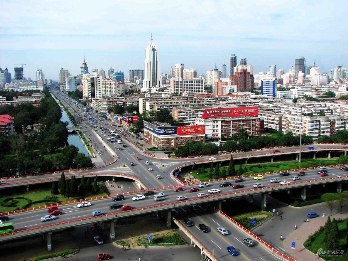
天津市,简称津,是中华人民共和国直辖市、国家中心城市和中国北方最大沿海开放城市。天津位于华北平原的海河各支流交汇处,东临渤海,北依燕山;有海河在城中蜿蜒而过,跨越海河的各式桥梁形成了“一桥一景”的景致。
天津因漕运而兴起,1404年12月23日正式筑城[1]。自1860年天津开放为通商口岸后,西方多国在天津设立租界,洋务派亦在天津兴办实业,使天津成为中国北方开放的前沿和近代中国洋务运动的基地。在领风气之先的同时,天津近代工业、商业、金融业等发展迅速。由天津开始的军事、教育、司法、交通、通讯、工业等方面的近代化建设,均开中国之先河。天津成为当时中国第二大的工商业城市和北方最大的金融商贸中心。
2006年3月,国务院批复的《天津市总体规划》将天津完整定位为“国际港口城市、北方经济中心、生态城市”[2],并将“推进天津滨海新区开发开放”纳入国家发展战略,设立为国家综合配套改革试验区。2007年11月,中国、新加坡两国政府选址天津共同建设中新生态城。2015年4月,中国(天津)自由贸易试验区挂牌成立,成为中国长江以北唯一的自由贸易试验区。经过自1990年代开始的工业东移战略,天津市已经初步形成了“中心城区-滨海新区”和“天津港-天津南港”的双城双港的城市格局。2015年4月,《京津冀协同发展纲要》确定天津市为“全国先进制造研发基地、北方国际航运核心区、金融创新运营示范区和改革先行示范区”[3]。
天津市举办了2013年的第六届东亚运动会和2017年第十三届全运会[4],同时天津也是夏季达沃斯论坛的常驻举办城市。
Die Stadt Tianjin liegt am westlichen Ufer des Bohai-Meeres, nordöstlich der Ostchinesischen Tiefebene, genauer sagt auf den Koordinaten von 38°33’ bis 40°15’ nördlicher Breite und 116°42’ bis 11803’ östlicher Länge. Im Norden grenzt sie an Beijing, im Osten, Westen und Süden an die Städte Tangshan, Chengde, Langfang und Cangzhou in der Provinz Hebei. Tianjin nimmt eine Fläche von 11.305 Quadratkilometern ein und die Küstenlinie der Stadt beträgt 133 Kilometer. Der Name Tianjin ("der Kaiser macht eine Überfahrt") entstand in der Ming-Dynastie, als der Ort für den Kaiser zu einer verkehrsgünstigen Anbindung zum Süden des Landes wurde. Der Bau der Stadt begann im Jahre 1404, als dort die Tianjiner Garnision angelegt wurde. So ist die Stadt zu einem Militärstützpunkt geworden.(Quelle:german.china.org.cn/german/209484.htm)
Tianjin (chinesisch 天津市, Pinyin Tiānjīn shì, W.-G. T’ien-chin ‚wörtl.: Himmelsfurt-Stadt‘, veraltet: nach Post, Stange Tientsin) ist eine wichtige Hafenstadt in der Volksrepublik China. Das gesamte Verwaltungsgebiet der Stadt hat eine Fläche von 11.943 Quadratkilometern. Tianjin ist eine der vier Regierungsunmittelbaren Städte in China, das heißt direkt der Zentralregierung in Peking unterstellt und hat damit denselben Status wie eine Provinz.
Das gesamte Verwaltungsgebiet Tianjins hat 12,3 Millionen Einwohner (Jahresende 2009).[1] Davon sind 9,5 Millionen registrierte Bewohner mit ständigem Wohnsitz (户口, hùkǒu) und 1,0 Millionen temporäre Einwohner (流动人口, liúdòng rénkǒu) mit befristeter Aufenthaltsgenehmigung (暂住证, zànzhùzhèng). Wird die Kernstadt (hohe Bebauungsdichte und geschlossene Ortsform) als Grundlage genommen, leben in Tianjin 3,8 Millionen Menschen mit Hauptwohnsitz (2007).[2] Der Ballungsraum (einschließlich Vororte) hat 6,4 Millionen Einwohner (2007).[3]
Die Stadt ist Industriezentrum, Verkehrsknoten und kultureller Mittelpunkt der Region mit Universitäten, Hochschulen, Museen und Baudenkmälern. Das Verwaltungsgebiet Tianjins stellt kein zusammenhängendes Stadtgebiet dar, sondern wäre – mit seiner dominierenden ländlichen Siedlungsstruktur – eher mit einer kleinen Provinz vergleichbar. Historisch war Tianjin die Hauptstadt der ehemaligen Provinz Zhili.
天津市(てんしんし/テンチンし、簡体字: 天津市、拼音: 、英語: Tianjin)は、中華人民共和国に位置する直轄市。国家中心都市の一つ。略称は津。
天津は華北平原海河の五大支流の合流する所に位置し、東に渤海を、北に燕山を臨む。市内を流れる海河は天津の母親河とも呼ばれる。
環渤海湾地域の経済的中心地であり、中国北方最大の対外開放港である。首都北京市とは高速道路、高速直通列車、京津城際線によって、0.5〜2時間以内で結ばれている。元々は海河の河港であったが、河口の塘沽に大規模な港湾やコンテナターミナル、工業地帯が形成されている。経済成長率の高さはここ数年に渡り、全国トップである。2017年の第13期の全国体育大会の開催が決まっており、夏季ダボスフォーラム常駐開催都市でもある。
市区人口は506万人、都市圏人口は720万人。
Tianjin ([tʰjɛ́n.tɕín] (![]() listen)), formerly romanized as Tientsin, is a coastal metropolis in northern China and one of the nine national central cities of the People's Republic of China (PRC), with a total population of 15,469,500, and is also the world's 11th-most populous city proper.[5] It is governed as one of the four municipalities under the direct administration of central government of the PRC and is thus under direct administration of the central government. Tianjin borders Hebei Province and Beijing Municipality, bounded to the east by the Bohai Gulf portion of the Yellow Sea. Part of the Bohai Economic Rim, it is the largest coastal city in northern China.
listen)), formerly romanized as Tientsin, is a coastal metropolis in northern China and one of the nine national central cities of the People's Republic of China (PRC), with a total population of 15,469,500, and is also the world's 11th-most populous city proper.[5] It is governed as one of the four municipalities under the direct administration of central government of the PRC and is thus under direct administration of the central government. Tianjin borders Hebei Province and Beijing Municipality, bounded to the east by the Bohai Gulf portion of the Yellow Sea. Part of the Bohai Economic Rim, it is the largest coastal city in northern China.
In terms of urban population, Tianjin is the fourth largest in China, after Shanghai, Beijing, and Guangzhou. In terms of administrative area population, Tianjin ranks fifth in Mainland China.[6] The walled city of Tianjin was built in 1404. As a treaty port since 1860, Tianjin has been a major seaport and gateway to Beijing. During the Boxer Rebellion the city was the seat of the Tianjin Provisional Government. Under the Qing dynasty and the Republic of China, Tianjin became one of the largest cities in the region.[7] At that time, numerous European-style buildings and mansions were constructed in concessions, many of which are well-preserved today. After the founding of the People's Republic of China, Tianjin suffered a depression due to the policy of the central government and Tangshan earthquake, but recovered from 1990s.[8] Nowadays Tianjin is a dual-core city, with its main urban area (including the old city) located along the Hai River, which connects to the Yellow and Yangtze Rivers via the Grand Canal; and Binhai, a New Area urban core located east of the old city, on the coast of the Bohai Gulf. As of the end of 2010, around 285 Fortune 500 companies have set up base in Binhai.
Tien-Tsin ou Tientsin (en français)2 ou Tianjin (nom local en anglais)3 (en chinois : 天津市 ; pinyin : ; EFEO : T'ien-Tsin), est une municipalité autonome du nord-est de la République populaire de Chine. Avec une agglomération de plus de quinze millions d'habitants en 2014, il s'agit de la quatrième ville de Chine en nombre d'habitants, après Shanghai, Pékin et Canton. Tianjin est également l'une des quatre municipalités du pays qui sont directement gouvernées par le pouvoir central. Elle est part du Jing-Jin-Ji.
Durant l'Antiquité, Tianjin était un village portuaire alors appelé Zhigu. Avec l'ouverture du Grand Canal sous la dynastie Sui (581-618), la ville se développe et devient un port de commerce important. En 1404, l'empereur Yongle donne à la ville son nom actuel, qui signifie littéralement le « gué de l'Empereur »4 , marquant le fait que le souverain a traversé le fleuve à cet endroit. Quelques années plus tard, un fort connu sous le nom de fort de Tianjin (Tianjin Wei, 天津卫) y est établi. En 1725, la ville obtient le statut de préfecture. Au XIXe siècle, les Chinois et les puissances occidentales s'y affrontent dans le cadre de la Seconde guerre de l'opium : la défaite chinoise et le traité de Tianjin (1858) entraînent la création de concessions étrangères. Devenue une ville de notables, Tianjin est occupée en 1937 par l'armée impériale japonaise à la suite du déclenchement de la guerre sino-japonaise.
Située sur les rives du golfe de Bohai — un bras de la mer Jaune — la municipalité de Tianjin est frontalière de la province Hebei et de la municipalité de Pékin. Elle se divise en deux ensembles urbains : la ville de Tianjin proprement dite, avec le centre historique, située sur les rives du fleuve Hai He - qui rejoint le fleuve Jaune (Huang He) et le Yangzi Jiang via le Grand Canal - ; et Binhai, une ville nouvelle située à l'est du centre historique, sur les rives de la mer de Bohai. Cette dernière, ainsi que le district de Tanggu voisin, est une zone économique spéciale destinée à accueillir de nombreuses entreprises chinoises et internationales. Sa croissance économique est l'une des plus importantes de Chine : le PIB de Binhai a dépassé en 2010 celui de Pudong à Shanghai5.
Symbole de ce récent développement économique - autour de l'aéronautique et de l'électronique notamment -, plusieurs gratte-ciels sont actuellement en construction, comme la China 117 Tower ou le Tianjin International Trade Centre. La ville abrite également un musée d'art chinois, le mémorial dédié à Zhou Enlai (le Premier ministre de Mao Zedong), le Temple de la Grande Compassion, ainsi que l'ancienne cathédrale de la concession française, l’Église Notre-Dame des Victoires. Plus récemment, la ville a accueilli des compétitions sportives dans son centre olympique, construit à l'occasion des Jeux olympiques de 2008 à Pékin.
Tientsin[1][2][3][4][5], conosciuta anche come Tianjin (pr. cinese: [tʰi̯ɛ́ntɕín]: pr. it. [tjɛnˈʤin][6]; in cinese 天津S, TiānjīnP, letteralmente "guado del fiume del paradiso"), è una delle quattro municipalità della Repubblica Popolare Cinese direttamente controllate dal governo centrale.
L'area metropolitana si estende su una superficie di 11 760 km² e nel 2014 aveva una popolazione di 15 200 000 abitanti – che la rendono la quarta municipalità della Cina per popolazione dopo Shanghai, Pechino e Chongqing.
Negli ultimi anni Tientsin, grazie alla presenza di un significativo bacino produttivo tecnologico, ha registrato una tra le maggiori crescite di PIL su base annua tra le città cinesi. Dal 2007 ospita la sessione estiva del Forum economico mondiale di Davos.
Tianjin1 (pronunciado:[Tián-Chín](![]() escuchar), en chino: 天津, pinyin: Tiānjìn, transcripción antigua: Tientsin) es uno de los cuatro municipios que, junto con las veintidós provincias, cinco regiones autónomas y dos regiones administrativas especiales, conforman la República Popular China. Está situado en China del Norte a orillas del río Hai en su desembocadura en el mar de Bohai. Es la cuarta ciudad más poblada de China tras Shanghái, Beijing y Guangzhou, con más de cuatro millones de habitantes en 170 kilómetros cuadrados que hacen un total de 15 469 500 habitantes.2
escuchar), en chino: 天津, pinyin: Tiānjìn, transcripción antigua: Tientsin) es uno de los cuatro municipios que, junto con las veintidós provincias, cinco regiones autónomas y dos regiones administrativas especiales, conforman la República Popular China. Está situado en China del Norte a orillas del río Hai en su desembocadura en el mar de Bohai. Es la cuarta ciudad más poblada de China tras Shanghái, Beijing y Guangzhou, con más de cuatro millones de habitantes en 170 kilómetros cuadrados que hacen un total de 15 469 500 habitantes.2
Tianjin es una de las cinco ciudades centrales nacionales, de gran relevancia histórica. La ciudad amurallada de Tianjin fue construida en 1404. Como puerto de tratado desde 1860, Tianjin ha sido un importante puerto marítimo y puerta de entrada a Beijing. Durante el levantamiento de los bóxers la ciudad fue la sede del Gobierno Provisional de Tianjin. Bajo el Imperio Ta-tsing y la República de China, Tianjin se convirtió en una de las ciudades más grandes de la región.3 En esa época, numerosos edificios y mansiones de estilo europeo fueron construidos en concesiones, muchas de las cuales están bien conservadas hoy en día. Después de la fundación de la República Popular de China, Tianjin sufrió una depresión debido a la política del gobierno central y el terremoto de Tangshan, pero se recuperó a partir de 1990.4
En la actualidad, Tianjin es una ciudad de dos núcleos, con su área urbana principal (incluyendo la ciudad vieja) situada a lo largo del río Hai, que conecta con los ríos Amarillo y Yangtze vía el Gran Canal y Binhai, un nuevo núcleo urbano situado al este de la ciudad vieja, en la costa del mar de Bohai. A finales de 2010, alrededor de 285 empresas Fortune 500 han establecido su base en Binhai, que es un nuevo polo de crecimiento en China y es un centro de la industria avanzada y la actividad financiera.
Тяньцзи́нь (кит. упр. 天津, пиньинь: Tiānjīn) — один из четырёх городов центрального подчинения Китайской Народной Республики. Городская зона Тяньцзиня является третьей по величине в континентальном Китае. Население — 14 425 000 человек (по данным 2009 года), площадь 11 943 км², ВВП — 750 млрд юаней (2009).