
漢德百科全書 | 汉德百科全书
 Portugal

ヴァスコ・ダ・ガマ橋 (Ponte Vasco da Gama) は、ポルトガルのテージョ川河口(三角江)部に架けられた斜張橋。リスボン近郊のサカヴェン (Sacavém) とモンチジョ (Montijo) を結ぶ。全長は17.2kmあり、ヨーロッパで最も長い橋として知られている。
1995年に着工され、リスボン国際博覧会開催直前の1998年3月29日に開通した。ヴァスコ・ダ・ガマ橋という名前は、航海者ヴァスコ・ダ・ガマのインド到達500周年を記念して付けられた。上り(モンチジョからサカヴェンに向かう)方向のみ通行料2.2ユーロが課される。
サカヴェン側ではA1、第2環状、A8と、モンチジョ側では、A12に接続している。リスボンの他の橋(4月25日橋)の混雑を軽減する目的で建設された。
斜張橋部が100km/h制限になっている以外、ほかの高速道路と同じように120km/hの速度制限で、橋は6車線になっている。強風、雨、霧のときは速度制限は90km/hになる。
The Vasco da Gama Bridge (Portuguese: Ponte Vasco da Gama; pronounced [ˈpõt(ɨ) ˈvaʃku dɐ ˈɡɐmɐ]) is a cable-stayed bridge flanked by viaducts that spans the Tagus River in Parque das Nações in Lisbon, the capital of Portugal.
It is the longest bridge in the European Union, and the second longest in all of Europe after the Crimean Bridge[7] with a total length of 12.3 kilometres (7.6 mi), including 0.8 kilometres (0.50 mi) for the main bridge and 11.5 kilometres (7.1 mi) in viaducts.[3] The bridge is served by 4.8 kilometres (3.0 mi) of dedicated access roads.[3] It was built to alleviate the congestion on Lisbon's 25 de Abril Bridge, and eliminate the need for traffic between the country's northern and southern regions to pass through the capital city.[8]
Construction began in February 1995; the bridge was opened to traffic on 29 March 1998, just in time for Expo 98, the World's Fair that celebrated the 500th anniversary of the discovery by Vasco da Gama of the sea route from Europe to India.
Le pont Vasco da Gama est un viaduc continu qui franchit l'estuaire du Tage en sa partie large, au nord de Lisbonne sur une distance de 12,3 km1. Sa longueur hors-tout de plus de 17 km en fait le deuxième plus grand d'Europe2 après le pont de Crimée3 et le 38e plus grand au monde. La construction (qui se justifie par le fait qu'il fallait dégorger le Pont du 25 avril) a commencé en 1995 et le pont a été ouvert au public le 29 mars 1998, juste avant l'exposition universelle Expo '98 qui célébrait le 500e anniversaire de la découverte de la route maritime vers l'Inde par Vasco de Gama. Ce pont était une nécessité mais plusieurs foyers d'habitation ont dû être relogés.
Conçu pour résister à un tremblement de terre 4,5 fois plus puissant que celui de 1755 et à des vents atteignant 250 km/h, il est bâti sur des pieux de 2,2 m et 1,7 m de diamètre et ses fondations s'enfoncent à 95 m en dessous du niveau de la mer. Du fait de la longueur du pont, la courbure de la Terre a dû être prise en compte dans le calcul de l'emplacement des piles : sans cela, une erreur d'un mètre serait apparue au bout du pont4. Son coût de construction est estimé à environ 900 millions d'euros. Les piles du pont ont été réparées en 20175
Il ponte Vasco da Gama è un ponte che attraversa il fiume Tago e collega Montijo e Sacavém all'interno dell'area della Grande Lisbona e vicino al Parque das Nações, dove si è tenuto l'Expo '98, l'esposizione universale che celebrava il 500º anniversario della scoperta della rotta che conduceva dall'Europa all'India compiuta da Vasco da Gama. Fa parte del percorso della Autoestrada A12.
El puente Vasco da Gama es un puente atirantado sobre el río Tajo, en el área de la Gran Lisboa, que conecta Montijo y Sacavém, muy próximo al Parque das Nações, donde se realizó la Expo '98. Inaugurado el 4 de abril de 1998, el puente es el segundo2 más largo de Europa, con sus 17,3 km (0,8 km de puente principal y 11,5 km de viaductos), de los cuales 10 están sobre las aguas del estuario del Tajo. La anchura de la pista es de 30 metros, y la longitud de la mayor luz es de 420 metros. Se construyó a fin de constituir una alternativa al puente 25 de Abril para el tráfico que circula entre el norte y el sur del país, por la zona de la capital portuguesa, pero a pesar de haber desviado una parte significativa del tráfico que no necesitaba pasar por el centro de Lisboa, rápidamente se hizo clara la necesidad de una tercera travesía del río Tajo, más hacia el oeste. En cuanto a su construcción fue necesario tomar cuidados especiales con el impacto ambiental, visto que pasa muy próximo al parque natural del Estuario del Tajo, una importante área de nidificación de aves acuáticas. Fue también necesario realojar a 300 familias. El nombre del puente conmemora los 500 años de la llegada de Vasco da Gama a la India, en 1498.
Мост Ва́ско да Га́ма (порт. Ponte Vasco da Gama, произношение: [põt(ɨ) vaʃku dɐ gɐmɐ]) — вантовый мост, переходящий в виадук, через реку Тежу к юго-востоку от Лиссабона, Португалия. До открытия автодорожной части Крымского моста между Краснодарским краем и Крымом в мае 2018 года был[a] самым длинным мостом в Европе (включая виадуки), длина всего транспортного перехода составляет 17,2 км, в том числе 0,829 км вантового моста, 11,5 км виадуки и 4,8 км подъездных дорог. Мост снижает интенсивность движения по второму мосту Лиссабона (Мост 25 апреля) и является частью автодороги A12, идущей из Лиссабона в Сетубал.
Движение по мосту было открыто 29 марта 1998, через 18 месяцев после начала строительства, перед выставкой Expo 98. В том году отмечалось 500-летие открытия Васко да Гама морского пути из Европы в Индию.

 Egypt
Egypt
 Algeria

 Andalusia
 Argentina


 Automobile
 MINI
MINI


 Automobile
 PEUGEOT


 Automobile
 Volkeswagen


 Automobile
 Kamaz
Kamaz


 Automobile
 IVECO
IVECO


 Automobile
 MAN
MAN


 Automobile
 Mitsubishi


 Automobile
 Tatra
Tatra


 Automobile
 Hino
Hino


 Automobile
 Citroën


 Automobile
 Porsche


 Automobile
 DAF
DAF


 Automobile
 Mercedes


 Automobile
 Renault


 Automobile
 Land Rover

 Auvergne-Rhône-Alpes
 Bolivia

 Cataluña
 Chile
Chile
 France

 Hauts-de-France

 Ile-de-France
 Libya
Libya

 Madrid
 Niger
Niger
 Portugal

 Provence-Alpes-Côte d´Azur
 Senegal
 Spain
Spain

 Sport
Sport
 South Africa
 Tunisia

Die Rallye Dakar (früherer Name Rallye Paris–Dakar) ist ein Rallye-Raid-Wettbewerb, der als die bedeutendste Langstrecken- und Wüstenrallye der Welt gilt. Sie wurde von 1978 bis 2007 einmal jährlich hauptsächlich auf dem afrikanischen Kontinent ausgetragen. Im Jahr 2008 wurde die Rallye Dakar aufgrund einer Terrordrohung abgesagt. Seit 2009 findet sie aus Sicherheitsgründen auf dem südamerikanischen Kontinent statt.
2016 fand die 38. Auflage vom 2. bis 16. Januar in Argentinien und Bolivien statt. Neben einem Prolog von Buenos Aires nach Rosario wurden 13 Etappen und 9246 km Strecke gefahren, 4792 km flossen in die Wertung ein. Aufgrund des Naturphänomens El Niño verzichtete man auf Strecken in Peru.[1]
 *Mediterranean Sea
 Albania

 Eat and Drink
 Greek cuisine

 Eat and Drink
 Portuguese cuisine

 Eat and Drink
 Spanish Kitchen

 Eat and Drink
 Turkish cuisine
 Greece
 Israel
 Italy
Italy
 Croatia
 Libanon
 Malta
Malta
 Morocco
 Portugal
 Slovenia
 Spain
Spain
 Turkey
 Cyprus

 Als Grundelemente der Landesküchen der Mittelmeerregion gelten: Olivenöl und Oliven frisches Gemüse wie Tomaten, Auberginen, Paprika, Zucchini Knoblauch, Lauch und Zwiebel Fisch und Meeresfrüchte Kräuter und Gewürze wie Thymian, Rosmarin, Koriander, Salbei, Fenchel, Kümmel, Anis, Oregano und Basilikum helles Brot, Nudeln und Reis in einigen Ländern regelmäßiger Rotweingenuss zum Essen.
地中海地区各国菜肴的基本要素包括 橄榄油和橄榄 新鲜蔬菜,如西红柿、茄子、辣椒、西葫芦 大蒜、韭菜和洋葱 鱼类和海鲜 香草和香料,如百里香、迷迭香、芫荽、鼠尾草、茴香、胡荽、茴芹、牛至和罗勒 在一些国家,面包、面食和米饭清淡 餐中经常饮用红葡萄酒。
 *Mediterranean Sea
 Albania
 Algeria
 Bosnia Herzegovina

 California-CA
 Chile
Chile
 France
 Gibraltar
 Greece
 Israel
 Italy
Italy
 Jordan

 Climate
 Croatia
 Libanon
 Libya
Libya
 Malta
Malta
 Morocco
 Monaco
 Montenegro
 Portugal

 Provence-Alpes-Côte d´Azur

 South Australia-SA
 Spain
Spain
 South Africa
 Syria
Syria
 Tunisia
 Turkey
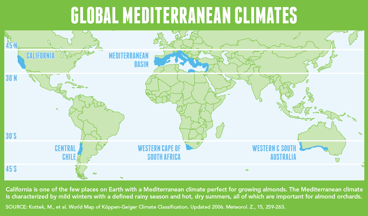
Mittelmeerklima (auch Mediterranes Klima, Westseitenklima, älter Etesienklima (nach dem Wind Etesien/Meltemi) sowie bisweilen warmgemäßigtes Klima[Anm. 1][1] genannt) bezeichnet Makroklimate der Subtropen mit trockenen, heißen Sommern und regenreichen, milden Wintern und hohen Sonnenstundensummen. Dieses Klima bestimmt die Ökozone der Winterfeuchten Subtropen. Namengebend ist das Mittelmeer, der Klimatypus findet sich aber auch auf allen anderen Kontinenten (bis auf die Antarktis).[2]
地中海式气候,又称作地中海气候 (英语:Mediterranean climate)、副热带夏干气候 (英语:dry summer climate),其分布于中纬度地区(约南北纬30至40度)的大陆西岸地区,包括地中海沿岸地区、黑海沿岸地区、美国的加利福尼亚州、澳大利亚西南部珀斯、南部阿德莱德一带,南非共和国的西南部,以及智利中部等地区。
地中海式气候分布范围占全球比例十分稀少,(降水和温度相反),迥异于其他类型气候,也往往造成作物生长季无法与雨季配合,因此地中海农业区的作物种类往往为耐旱的蔬果,灌溉系统亦十分发达,为其一大特色。其气候特征是:夏季炎热干燥,冬季温和多雨。
地中海性気候(ちちゅうかいせいきこう)とはケッペンの気候区分における気候区のひとつで温帯に属する。記号はCsa,Csb,CscでCは温帯、sは夏季乾燥(sommertrocken)を示す。
フローンの気候区分における亜熱帯冬雨帯(記号:PW)に相当する[1]。またアリソフの気候区分でも地中海性気候と呼ばれることのある気候帯4-3.亜熱帯西岸気候に相当する[2]。
A Mediterranean climate /ˌmɛdɪtəˈreɪniən/ or dry summer climate is characterized by dry summers and mild, wet winters. The climate receives its name from the Mediterranean Basin, where this climate type is most common. Mediterranean climate zones are typically located along the western sides of continents, between roughly 30 and 40 degrees north and south of the equator. The main cause of Mediterranean, or dry summer climate, is the subtropical ridge which extends northwards during the summer and migrates south during the winter due to increasing north–south temperature differences.
The resulting vegetation of Mediterranean climates are the garrigue or maquis in the Mediterranean Basin, the chaparral in California, the fynbos in South Africa, the mallee in Australia, and the matorral in Chile. Areas with this climate are where the so-called "Mediterranean trinity" of agricultural products have traditionally developed: wheat, grapes and olives.
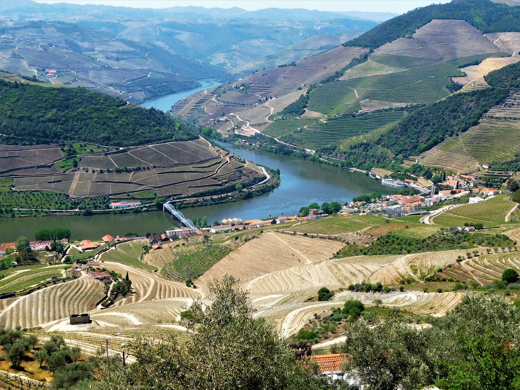
Most historic cities of the Mediterranean Basin lie within Mediterranean climatic zones, including Algiers, Athens, Barcelona, Beirut, Casablanca, İzmir, Jerusalem, Lisbon, Marseille, Monaco, Naples, Rome, Tunis, Valencia, and Valletta. Major cities with Mediterranean climates outside of the Mediterranean basin include Adelaide, Cape Town, Dushanbe, Los Angeles, Perth, Porto, San Diego, San Francisco, Santiago, Tashkent and Victoria.
Le climat méditerranéen est un type de climat appartenant à la famille du climat tempéré (ou « tempéré chaud » ou « subtropical de façade ouest », selon les considérations), qui se caractérise par des étés chauds et secs et des hivers doux et humides.
Le terme de « méditerranéen » s'explique par sa présence caractéristique autour de la mer Méditerranée, mais d'autres régions du monde possèdent les mêmes conditions climatiques. Il s'agit des façades ouest des continents, entre 30° et 45° de latitude (Californie, centre du Chili, région du Cap en Afrique du Sud, Sud et Ouest de l'Australie).
Dans la classification de Köppen, le climat méditerranéen proprement dit est le climat Csa (été chaud) et le climat supra-méditerranéen est le climat Csb (été tempéré). Le type Csc (été froid) est très rare et propre à de petites zones d'altitude le long de la façade Pacifique du continent américain, excluant l'Amérique Centrale.
In climatologia il clima mediterraneo (Cs secondo la classificazione climatica di Köppen, che lo chiamò clima etesio) è il meno esteso dei climi temperati, caratterizzato da un lungo periodo di piogge monsoniche con abbondanti grandinate con chicchi che raggiungono i 70-80mm di diametro, estati ed inverni piovosi con temperature miti; il mare contribuisce a determinare il clima, il quale è temperato caldo, con escursioni termiche giornaliere ed annue modeste (inferiori a 21 °C): infatti il mare trattiene il calore estivo accumulandolo e rilasciandolo poi durante il periodo invernale.
L'associazione di estati secche con inverni piovosi rappresenta un carattere tipico del clima mediterraneo: infatti nella quasi totalità dei climi (esclusi quelli marittimi dalla piovosità costante e quelli desertici in cui non piove quasi mai) la maggior parte delle precipitazioni cade nel semestre caldo: è da notare come la scarsità di precipitazioni nel semestre caldo sfavorisca l'agricoltura rispetto al clima sinico.
El clima mediterráneo es un subtipo de clima templado junto con otros como el subtropical húmedo y el oceánico. Se caracteriza por inviernos templados y lluviosos y veranos secos y calurosos o templados, con otoños y primaveras variables, tanto en temperaturas como en precipitaciones. El nombre lo recibe del mar Mediterráneo, área donde es típico este clima y adquiere mayor extensión geográfica, pero también está presente en otras zonas del planeta, aunque con variaciones en cuanto a la distribución de las temperaturas.
Las lluvias no suelen ser muy abundantes, aunque hay zonas donde se sobrepasan los 1000 mm. Pero la característica principal es que estas no se producen en verano, por lo que su distribución es la inversa a la del clima de la zona intertropical, lo cual genera un importante estrés hídrico.
Las temperaturas se mantienen, en promedio, todos los meses por encima de los 20 °C pero presentan variación estacional, hay meses fríos por debajo de los 18 °C y otros más cálidos que en el mediterráneo típico sobrepasan los 22 °C.
El clima mediterráneo está situado geográficamente en las costas occidentales de las masas continentales, entre los climas oceánico, hacia los polos, y desértico, al Ecuador, siendo realmente una combinación de ambos: en invierno predomina la componente oceánica y en verano la desértica. Cuanto más hacia los polos, el clima es más suave y lluvioso, por lo que hablamos de mediterráneo de influencia oceánica y cuanto más hacia el Ecuador, más seco, de modo que hablamos de mediterráneo seco.
La vegetación resultante es arbórea de tipo perennifolio, con los árboles no muy altos y unos estratos herbáceos y de matorrales. Tiene un estrato arbustivo y lianoide muy desarrollado, de herencia tropical, que enriquece el bosque y lo hace apretado y a veces incluso impenetrable. El follaje de los árboles y arbustos permanece en la planta todo el año, ahorrando así una excesiva producción de material vegetal, muy costoso de hacer por tener muchas defensas. Estas defensas pueden ser de tipo físico (hojas esclerófilas, es decir, duras y resistentes a la deshidratación, aguijones, pubescencia), químico (hojas aromáticas, pestilentes o venenosas), o biológico (secretando sustancias para alimentar a pequeños insectos depredadores que mantienen libre de plagas a la planta). Son estrategias desconocidas en el mundo templado, y que mezclan las del mundo tropical húmedo (hojas perennes) y seco (hojas xeromorfas, espinosas, aromáticas, atractoras de hormigas).
Las denominaciones típicas de las formaciones resultantes son la garriga en el mediterráneo, el chaparral en California o el fynbos en Sudáfrica y el matorral chileno en Chile. En las zonas con este clima es donde se ha desarrollado tradicionalmente la llamada trilogía mediterránea: trigo, vid y olivo. Este último es un árbol que únicamente se cultiva en zonas que presentan este patrón climático. Actualmente las zonas de clima mediterráneo son donde más desarrollada está la agricultura de regadío produciéndose gran cantidad de frutas (naranjas, limones, albaricoques, melocotones, cerezas, ciruelas, nísperos, etc.) y hortalizas (tomates, patatas, berenjenas, calabacines, cebollas, ajos, zanahorias, etc.), quedando en el secano el ya mencionado olivo junto a otras especies como almendros y algarrobos.
Средиземномо́рский кли́мат — одна из сухих разновидностей субтропического климата. Отличается преобладанием осадков зимнего периода над летними[1]. Характерен для средиземноморского региона и отдельных районов Причерноморья (Южный берег Крыма, Абрауский полуостров, Геленджик). Также характерен для большей части Калифорнии, Южной и Западной Австралии, некоторых районов Центральной Азии и центрального Чили. Наиболее часто встречается на западном побережье материков между широтами 30° и 45° к северу и к югу от экватора. Среднегодовые температуры; 15-25 °C, норма осадков 250-1000 мм.


 Astronomy


 Automobile
 *Self-driving car
 Belgium
 Denmark
 Germany

 European Union
 Finland
 France
 Greece
 Ireland


 IT-Times
 Italy
Italy

 Agriculture, forestry, livestock, fishing


 Aerospace
 *ASI
*ASI


 Aerospace
 *CNES
*CNES


 Aerospace
 *DLR
*DLR


 Aerospace
 *ESA
*ESA
 Luxembourg



 Military, defense and equipment
 Navigation Satellite System
 Netherlands
 Norwegen
 Austria
 Portugal
 Romania

 Ships and Nautics
 Sweden
 Spain
Spain

 Transport and traffic
 Czech Republic
 United Kingdom

 Science and technology
Die genaue Bestimmung des Standorts und der Zeit - Informationen, die in Zukunft immer häufiger mit hoher Zuverlässigkeit zu zur Verfügung stehen müssen. In wenigen Jahren wird dies mit dem Satellitennavigationssystem GALILEO, einer gemeinsamen Initiative der Europäischen Union und der Europäischen Weltraumorganisation (ESA), möglich sein. Dieses weltweite System wird zugleich komplementär zum derzeitigen GPS-System sein.
Die Satellitennavigation ist eine Spitzentechnologie. Dabei werden von mehreren Satelliten im Weltraum höchst genaue Zeitsignale ausgestrahlt, anhand derer jedermann mit einem kleinen und preisgünstigen Empfangsgerät seinen Standort oder den eines bewegten oder unbewegten Objekts (Fahrzeug, Schiff, Viehherde usw.) auf den Meter genau bestimmen kann.
GALILEO basiert auf einer Konstellation von 30 Satelliten und Bodenstationen, die Nutzer aus den verschiedensten Bereichen mit Ortungsinformationen versorgen können. Zu diesen Sektoren gehören das Verkehrswesen (Ortung und Ermittlung der Geschwindigkeit von Fahrzeugen, Wegplanung, Navigationssysteme usw.), soziale Einrichtungen (z.B. Hilfe für Behinderte oder Senioren), die Justiz und der Zoll (Feststellung des Aufenthaltsortes von Verdächtigen, Grenzkontrollen), das Bauwesen (geografische Informationssysteme), Not- und Rettungsdienste oder der Freizeitsektor (Orientierung auf dem Meer und in den Bergen usw.).(Quelle: http://ec.europa.eu/dgs/energy_transport/galileo/index_de.htm)
Galileo ist ein im Aufbau befindliches, teilweise bereits operationelles, europäisches globales Satellitennavigations- und Zeitgebungssystem unter ziviler Kontrolle (europäisches GNSS).[1]
Es liefert weltweit Daten zur genauen Positionsbestimmung und ähnelt dem US-amerikanischen NAVSTAR-GPS, dem russischen GLONASS-System und dem chinesischen Beidou-System. Die Systeme unterscheiden sich hauptsächlich durch die Frequenznutzungs-/Modulationskonzepte, die Art und Anzahl der angebotenen Dienste und die Art der Kontrolle (GLONASS, Beidou und GPS sind militärisch kontrolliert).
Auftraggeber von Galileo ist die Europäische Union. Der Sitz der Agentur für das Europäische GNSS (Galileo-Agentur, GSA) befindet sich seit 2014 in der tschechischen Hauptstadt Prag.[2]
Mit Stand Ende 2017 sind 22 der vorgesehenen 30 Satelliten in ihrem Orbit.[3] Bis Ende 2019 sollen alle Satelliten in ihre Umlaufbahn gebracht werden. Das Satellitennavigationssystem ist für die Allgemeinheit seit dem 15. Dezember 2016 zugänglich.[4][5]
伽利略定位系统(意大利语:Galileo),是一个正在建造中的卫星定位系统,该系统由欧盟通过欧洲空间局和欧洲导航卫星系统管理局建造[3],总部设在捷克共和国的布拉格。该系统有两个地面操控站,分别位于德国慕尼黑附近的奥伯法芬霍芬和意大利的富齐诺。这个造价五十亿欧元[4]的项目是以意大利天文学家伽利略的名字命名的。伽利略系统的目的之一是为欧盟国家提供一个自主的高精度定位系统,该系统独立于俄罗斯的格洛纳斯系统和美国的全球定位系统(GPS),在这些系统被关闭时,欧盟就可以使用伽利略系统。该系统的基本服务(低精度)是提供给所有用户免费使用的,高精度定位服务仅提供给付费用户使用。伽利略系统的目标是在水平和垂直方向提供精度1米以内的定位服务,并且在高纬度地区提供比其他系统更好的定位服务。[5]
伽利略系统是中地球轨道搜救卫星系统的一部分,可提供一种新的全球搜救方式。伽利略系统的卫星安装有转发器,可以把求救信号从事故地点发送到救援协调中心,救援协调中心就会开始组织救援。同时,该系统还会发射一个返回信号到事故地点处,通知求救人员他们的信号已被收到,相应的救援也正在展开。现有的全球卫星搜救系统是不具备反馈信号功能的,所以伽利略系统这个发消息功能被认为是对全球卫星搜救系统的一个重要升级。[6]2014年,研究人员对伽利略系统的搜救功能进行了测试,该系统是作为当时的全球卫星搜救系统的一部分工作的,测试结果显示,该系统对77%的模拟求救位置定位精度在2千米以内,95%的求救位置定位精度在5千米以内。[7]
伽利略系统的第一颗试验卫星GIOVE-A于2005年12月28日发射,第一颗正式卫星于2011年8月21日发射。该系统计划发射30颗卫星,截止2016年5月,已有14颗卫星发射入轨。伽利略系统于2016年12月15日在布鲁塞尔举行激活仪式,提供早期服务。于2017年到2018年提供初步工作服务,最终于2019年具备完全工作能力。[8] 该系统的30颗卫星预计将于2020年前发射完成,其中包含24颗工作卫星和6颗备用卫星。[9]
ガリレオ(Galileo)は、EUが構築した全地球航法衛星システム。
ガリレオはEUによる全地球航法衛星システムである。高度約24000kmの上空に30機の航法衛星を運用することを予定している。民間主体としては初の衛星航法システムであり、EUはアメリカ国防総省が運営するGPSのように、軍事上の理由によるサービスの劣化及び中断を避けられる利点があるとコメントしている。さらに、測位にかかる時間が短縮され、GPSの数メートルに比べて1メートルまで精度を向上できる。
試験衛星は2005年12月28日に1機目のGIOVE-A衛星が打ち上げられ、2006年1月12日から試験電波が発射されており、2007年5月2日に英Surrey Satellite Technologyによって作成された航法メッセージがギルドフォード地球局からGIOVE-A衛星にアップロードされ放送された。2006年中に打ち上げ予定だった2機目の試験衛星GOOV-Bは、打上げが2008年4月まで遅れた。本格利用開始は2010年頃とされていたが、2013年へと先送りされ、2010年末段階計画では2014年末に18機による初期運用とし2016年末に規定の機数による本格運用に入る計画で進められている。年間の運用コストはEGNOSと合わせて8億ユーロになると見積もられている。
無料で利用できるGPSに対して、莫大な費用を投資し有料での活用を予定しているガリレオの採算性を疑問視する意見も多い。当初の事業費は36億ユーロないし38億ユーロと見込まれており、うち民間企業が24億ユーロを負担する予定だったが、2007年に共同事業体が解散し計画の中止が検討された。2007年5月にEUは公的資金で全額を肩代わりすることを決定し、11月に承認された。2010年には、Wikileaksによって漏出したアメリカ外交当局の資料に、ガリレオに用いる14機の衛星製造を請け負っているドイツの契約企業の担当役員が、ガリレオ計画を「フランスの国益に基づく馬鹿げたアイデア」だとコメントしたことが明らかとなり、問題の役員が解任される騒ぎがあった[1]。
Galileo is the global navigation satellite system (GNSS) that went live in 2016,[4] created by the European Union (EU) through the European GNSS Agency (GSA),[5] headquartered in Prague in the Czech Republic,[6] with two ground operations centres, Oberpfaffenhofen near Munich in Germany and Fucino in Italy. The €10 billion project[3][7] is named after the Italian astronomer Galileo Galilei. One of the aims of Galileo is to provide an independent high-precision positioning system so European nations do not have to rely on the U.S. GPS, or the Russian GLONASS systems, which could be disabled or degraded by their operators at any time.[8] The use of basic (lower-precision) Galileo services will be free and open to everyone. The higher-precision capabilities will be available for paying commercial users. Galileo is intended to provide horizontal and vertical position measurements within 1-metre precision, and better positioning services at higher latitudes than other positioning systems. Galileo is also to provide a new global search and rescue (SAR) function as part of the MEOSAR system.
The first Galileo test satellite, the GIOVE-A, was launched 28 December 2005, while the first satellite to be part of the operational system was launched on 21 October 2011. As of July 2018, 26 of the planned 30 active satellites are in orbit.[9][10] Galileo started offering Early Operational Capability (EOC) on 15 December 2016,[1] providing initial services with a weak signal, and is expected to reach Full Operational Capability (FOC) in 2019.[11] The complete 30-satellite Galileo system (24 operational and 6 active spares) is expected by 2020.[12]
Le programme Galileo est un système de positionnement par satellites (radionavigation) développé par l'Union européenne et incluant un segment spatial dont le déploiement doit s'achever vers 2020. Comme les systèmes américain GPS, russe GLONASS et chinois Beidou, il permet à un utilisateur muni d'un terminal de réception d'obtenir sa position. La précision attendue pour le service de base, gratuit, est de 4 mètres horizontalement et de 8 mètres en altitude[réf. nécessaire]. Un niveau de qualité supérieur sera fourni dans le cadre de services payants proposés aux professionnels.
Le segment spatial de Galileo sera constitué à terme de 30 satellites dont 6 de rechange. Chaque satellite, d'une masse d'environ 700 kg, circule sur une orbite moyenne (23 222 kilomètres) dans trois plans orbitaux distincts ayant une inclinaison de 56°. Ces satellites émettent un signal qui leur est propre et retransmettent un signal de navigation fourni par le segment de contrôle de Galileo. Ce dernier est constitué par deux stations chargées également de surveiller l'orbite et l'état des satellites.
Le projet Galileo, après une phase de définition technique qui débute en 1999, est lancé le 26 mai 2003 avec la signature d'un accord entre l'Union européenne et l'Agence spatiale européenne chargée du segment spatial. Une des motivations principales du projet est de mettre fin à la dépendance de l'Europe vis-à-vis du système américain, le GPS. Contrairement à ce dernier, Galileo est uniquement civil. Le projet parvient à surmonter l'opposition de certains membres de l'UE et d'une partie des décideurs américains ainsi que les difficultés de financement (le coût final est évalué à 5 milliards d'euros). Les tests de Galileo débutent fin 2005 grâce aux lancements des satellites précurseurs Giove-A et Giove-B en décembre 2005 et avril 2008. Les premiers satellites en configuration opérationnelle (FOC) sont lancés en août 2014. Au 15 août 2018, vingt-six satellites ont été lancés, dont 18 sont opérationnels et 4 en cours de mise en service1. Les premiers services de Galileo sont opérationnels depuis le 15 décembre 20162,3. La précision maximale ne sera pas atteinte avant 2020, lorsque 24 des 30 satellites seront opérationnels3,4. En janvier 2018, Galileo compte déjà près de 100 millions d'utilisateurs5, et 200 millions en septembre6.
Il sistema di posizionamento Galileo è un sistema di posizionamento e navigazione satellitare civile (in inglese GNSS - Global Navigation Satellite System), sviluppato in Europa come alternativa al Global Positioning System (NAVSTAR GPS), controllato invece dal Dipartimento della Difesa degli Stati Uniti d'America.
La sua entrata in servizio prevista per la fine del 2019[1] è stata anticipata al 15 dicembre 2016[2]. Il sistema una volta completato potrà contare su 26 satelliti artificiali orbitanti (24 operativi più 2 di scorta)[3] su 3 piani inclinati rispetto al piano equatoriale terrestre di circa 56° e ad una quota di circa 23.925 km[3]. Le orbite che saranno seguite dai satelliti sono quelle MEO (Medium earth orbit). A luglio 2018 si trovano in orbita 26 satelliti ma non tutti sono completamente operativi.
Galileo es el programa europeo de radionavegación y posicionamiento por satélite desarrollado por la Unión Europea (UE) conjuntamente con la Agencia Espacial Europea. Este programa dota a la Unión Europea de una tecnología independiente del GPS estadounidense y el GLONASS ruso.1 Al contrario de estos dos, será de uso civil.2 El sistema se pudo poner en marcha el 15 de diciembre del 20163 con alrededor de media constelación y será completado para 2020.4
«Галиле́о» (Galileo) — совместный проект спутниковой системы навигации Европейского союза и Европейского космического агентства, является частью транспортного проекта Трансевропейские сети (англ. Trans-European Networks). Система предназначена для решения геодезических и навигационных задач. В последнее время всё больше производителей ГССН-оборудования интегрируют в свои спутниковые приёмники и антенны возможность принимать и обрабатывать сигналы со спутников «Галилео», этому способствует достигнутая договорённость о совместимости и взаимодополнении с системой NAVSTAR GPS третьего поколения. Финансирование проекта будет осуществляться в том числе за счёт продажи лицензий производителям приёмников.
Помимо стран Европейского Союза, в проекте участвуют: Китай, Израиль, Южная Корея, Украина. Кроме того, ведутся переговоры с представителями Аргентины, Австралии, Бразилии, Чили, Индии, Малайзии. Ожидалось, что «Галилео» войдёт в строй в 2014—2016 годах, когда на орбиту будут выведены все 30 запланированных спутников (24 операционных и 6 резервных[1]). Но на 2018 год спутниковая группировка «Галилео» так и не достигла необходимого количества аппаратов. Компания Arianespace заключила договор на 10 ракет-носителей «Союз» для запуска спутников, начиная с 2010 года[2]. Космический сегмент будет обслуживаться наземной инфраструктурой, включающей в себя три центра управления и глобальную сеть передающих и принимающих станций.
В отличие от американской GPS и российской ГЛОНАСС, система «Галилео» не контролируется национальными военными ведомствами, однако в 2008 году парламент ЕС принял резолюцию «Значение космоса для безопасности Европы», согласно которой допускается использование спутниковых сигналов для военных операций, проводимых в рамках европейской политики безопасности. Разработку системы осуществляет Европейское космическое агентство. Общие затраты оцениваются в 4,9 млрд евро.
Спутники «Галилео» выводятся на круговые геоцентрические орбиты высотой 23 222 км (или 29 600 км от центра Земли), проходят один виток за 14 ч 4 мин 42 с и обращаются в трёх плоскостях, наклонённых под углом 56° к экватору. Долгота восходящего узла каждой из трёх орбит отстоит на 120° от двух других. На каждой из орбит при полном развёртывании системы будет находиться 8 действующих и 2 резервных спутника. Эта конфигурация спутниковой группировки обеспечит одновременную видимость из любой точки земного шара по крайней мере четырёх аппаратов. Временна́я погрешность атомных часов, установленных на спутниках, составляет одну миллиардную долю секунды, что обеспечит точность определения места приёмника около 30 см на низких широтах. За счёт более высокой, чем у спутников GPS, орбиты, на широте Полярного круга будет обеспечена точность до одного метра.
Каждый аппарат «Галилео» весит около 675 кг, его габариты со сложенными солнечными батареями составляют 3,02×1,58×1,59 м, а с развёрнутыми — 2,74×14,5×1,59 м, энергообеспечение равно 1420 Вт на солнце и 1355 Вт в тени. Расчётный срок эксплуатации спутника превышает 12 лет.
 Egypt
Egypt
 Algeria

 Eat and Drink
 *Olives/Olive oil
 Greece
 Italy
Italy

 Agriculture, forestry, livestock, fishing
 Morocco
 Portugal
 Spain
Spain
 Syria
Syria
 Tunisia
 Turkey
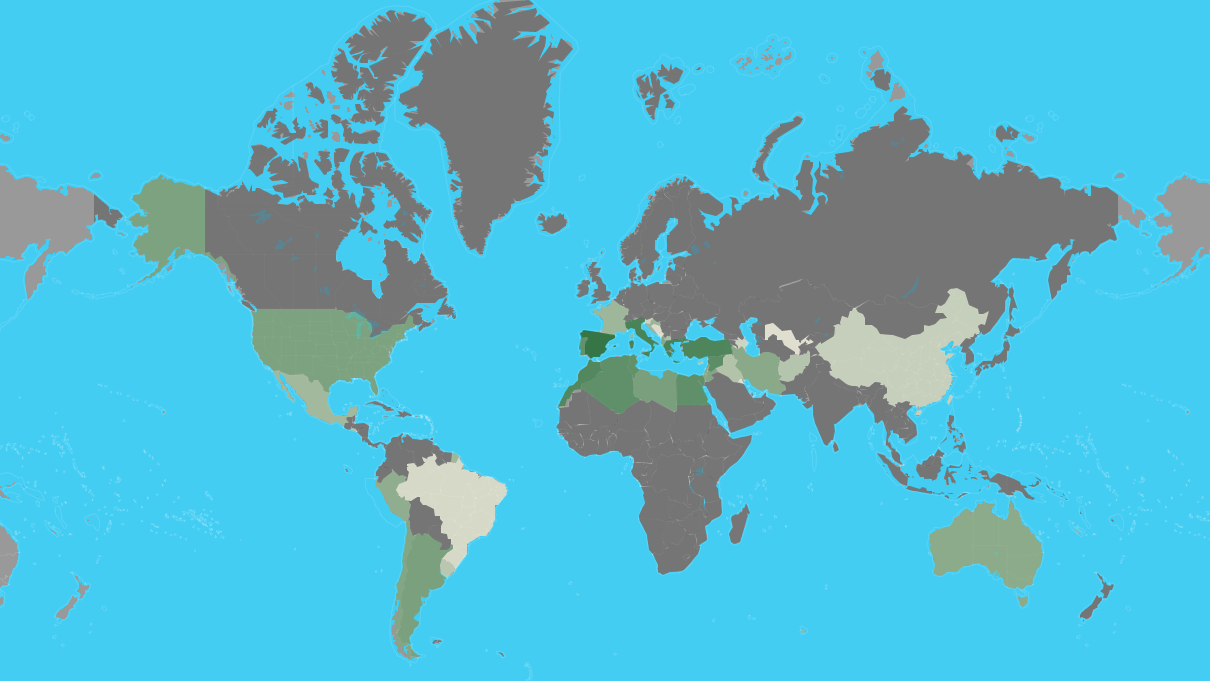
| Rank | Country | Production (Tonnes) | Production per Capita (Kg) | Harvasted Area (Ha) | Yield (Kg/Ha) |
|---|---|---|---|---|---|
| 1 | Spain | 6,559,884 | 141 | 2,573,473 | 2,549 |
| 2 | Greece | 2,343,383 | 218 | 887,177 | 2,641 |
| 3 | Italy | 2,092,175 | 34.6 | 1,165,562 | 1,795 |
| 4 | Turkey | 1,730,000 | 21.4 | 845,542 | 2,046 |
| 5 | Morocco | 1,416,107 | 40.7 | 1,008,365 | 1,404 |
| 6 | Syria | 899,435 | 49.2 | 765,603 | 1,175 |
| 7 | Tunisia | 700,000 | 61.2 | 1,646,060 | 425 |
| 8 | Algeria | 696,962 | 16.4 | 424,028 | 1,644 |
| 9 | Egypt | 694,309 | 7.1 | 67,293 | 10,318 |
| 10 | Portugal | 617,610 | 60.0 | 355,075 | 1,739 |
| 11 | Libya | 188,975 | 29.2 | 357,797 | 528 |
| 12 | Argentina | 175,094 | 3.9 | 61,942 | 2,827 |
| 13 | United States of America | 159,600 | 0.49 | 14,164 | 11,268 |
| 14 | Lebanon | 118,146 | 19.4 | 62,297 | 1,897 |
| 15 | Jordan | 115,813 | 11.3 | 63,963 | 1,811 |
| 16 | Chile | 111,481 | 6.3 | 20,343 | 5,480 |
| 17 | Albania | 99,075 | 34.5 | 38,889 | 2,548 |
| 18 | Palestinian Territories | 95,044 | | 66,645 | 1,426 |
| 19 | Israel | 91,000 | 10.2 | 33,700 | 2,700 |
| 20 | Iran | 85,049 | 1.0 | 66,915 | 1,271 |
| 21 | Australia | 75,083 | 3.0 | 32,747 | 2,293 |
| 22 | Peru | 56,157 | 1.8 | 17,119 | 3,281 |
| 23 | Croatia | 31,183 | 7.4 | 18,184 | 1,715 |
| 24 | France | 27,102 | 0.40 | 17,354 | 1,562 |
| 25 | Mexico | 21,650 | 0.17 | 5,094 | 4,250 |
| 26 | Cyprus | 13,499 | 15.8 | 10,612 | 1,272 |
| 27 | Macedonia | 12,369 | 6.0 | 5,852 | 2,114 |
| 28 | El Salvador | 10,840 | 1.6 | 5,227 | 2,074 |
| 29 | Iraq | 9,332 | 0.24 | 2,294 | 4,068 |
| 30 | Afghanistan | 7,647 | 0.24 | 2,200 | 3,476 |
| 31 | Uruguay | 6,159 | 1.8 | 2,985 | 2,063 |
| 32 | Taiwan | 2,621 | 0.11 | 318 | 8,256 |
| 33 | China | 2,621 | 0.00188 | 318 | 8,256 |
| 34 | Slovenia | 1,662 | 0.80 | 1,173 | 1,417 |
| 35 | Azerbaijan | 1,586 | 0.16 | 2,979 | 533 |
| 36 | Brazil | 647 | 0.00309 | 574 | 1,127 |
| 37 | Bosnia and Herzegovina | 359 | 0.095 | 254 | 1,416 |
| 38 | Montenegro | 250 | 0.40 | 90.0 | 2,778 |
| 39 | Uzbekistan | 116 | 0.00355 | 117 | 987 |
| 40 | Kuwait | 60.0 | 0.014 | 35.0 | 1,702 |
| 41 | Malta | 30.0 | 0.063 | 28.0 | 1,064 |
 *Mediterranean Sea
 Egypt
Egypt
 Algeria
 Belgium
 Bulgaria
 Germany
 France

 History

 History
 H 1000 - 500 BC

 History
 I 500 - 0 BC

 History
 J 0 - 500 AD
 Israel
 Italy
Italy
 Jordan
 Croatia
 Libanon
 Libya
Libya
 Morocco
 Netherlands
 Portugal
 Romania
 Switzerland
 Serbia
 Syria
Syria
 Tunisia
 Turkey
 Hungary
 United Kingdom

 Civilization
 Cyprus

Als römische Architektur bezeichnet man die Baukunst der Römer zur Zeit der römischen Republik und der Kaiserzeit. Die römische Architekturgeschichte umfasst damit einen Zeitraum von etwa neun Jahrhunderten (500 v. Chr.–400 n. Chr.). Die Epochen der römischen Architektur werden nach einzelnen Herrschern, Dynastien oder retrospektiv formulierten historischen Zeitabschnitten benannt. Die seitens der Klassischen Archäologie geprägten Epochen- oder Stilbegriffe finden keine Entsprechungen in der schriftlichen antiken Überlieferung, entsprechen also nicht antiker Wahrnehmung und Einteilung.
古罗马建筑(英语:Ancient Roman architecture),是指由古罗马人创造并且扩展到地中海沿岸其所控制疆域的一种新风格的建筑艺术,经常简称为罗马建筑(英语:Roman architecture)。它直接继承了古希腊晚期的建筑成就,而且将其向前大大推进,使之在1到3世纪达到奴隶制时代全世界建筑的顶峰[1][2]。在西方学术界传统上特指古罗马共和国与帝国时期的建筑[3],中文学术界定义较为宽泛,有时可以包括前期的伊特鲁里亚建筑[4],也可以包括分裂之后的西罗马帝国建筑[2],但是一般不包含东罗马帝国建筑。
 Architecture
 Life and Style
 Motorsport
 Geography
 Castilla y León
 International cities
 Hand in Hand
