
Deutsch-Chinesische Enzyklopädie, 德汉百科
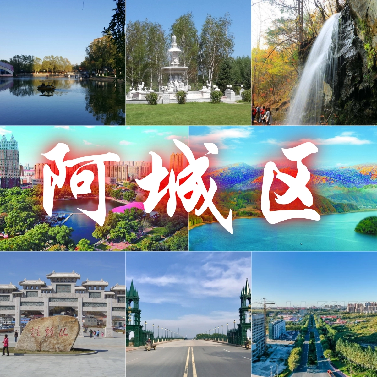
 Heilongjiang Sheng-HL
Quelle:https://baike.baidu.com/
| 文献 | 版本 |
|---|---|
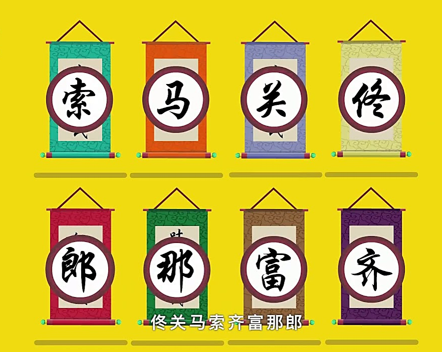
| 《八旗满洲氏族通谱》[3] | 瓜尔佳氏、钮祜禄氏、舒穆禄氏、赫舍里氏、他塔喇氏、觉罗氏、佟佳氏、那拉氏 |
| 《清稗类钞》[4]、《郎潜纪闻初笔》[5]等 | 瓜尔佳氏、钮祜禄氏、舒穆禄氏、纳喇氏、栋鄂氏、马佳氏、伊尔根觉罗氏[註 1]、辉发氏[註 2] |
| 《道咸以来朝野杂记》[8] | 瓜尔佳氏、钮祜禄氏、舒穆禄氏、那拉氏、完颜氏、富察氏、费莫氏、章佳氏 |
| 《庫雅喇氏源流考》[9] | 瓜尔佳氏、钮祜禄氏、觉尔察氏、栋鄂氏、佟佳氏、兆佳氏、伊尔根觉罗氏、他塔拉氏 |
| 《他塔拉氏家譜》[9] | 瓜尔佳氏、钮祜禄氏、赫舍里氏、章佳氏、马佳氏、宁古塔氏、扎拉里氏、伊尔根觉罗氏 |
| 《满族史论丛》[9] | 瓜尔佳氏、钮祜禄氏、舒穆禄氏、纳兰氏、董鄂氏、赫舍里氏、乌拉氏、伊尔根觉罗氏 |
| 京旗民间[10][11] | 瓜尔佳氏、钮祜禄氏、马佳氏、索绰罗氏、齐佳氏、富察氏、那木都鲁氏、佟佳氏 或 瓜尔佳氏、钮祜禄氏、舒穆禄氏、董鄂氏、马佳氏、纳喇氏、索绰罗氏、赫舍里氏 |
| 《兴京县志》、《凤城县志》、东北民间等[12] | 瓜尔佳氏、钮祜禄氏、马佳氏、索绰罗氏(或赫舍里氏)、齐佳氏(或喜塔腊氏)、富察氏、那拉氏、佟佳氏 |
Anhui Sheng-AH
Beijing Shi-BJ
China
Chongqing Shi-CQ
Fujian Sheng-FJ
Gansu Sheng-GS
Gansu Sheng-GS
Guangxi Zhuangzu Zizhiqu-GX
Guizhou Sheng-GZ
Hainan Sheng-HI
Hebei Sheng-HE
Heilongjiang Sheng-HL
Henan Sheng-HA
Hongkong Tebiexingzhengqu-HK
Hubei Sheng-HB
Hunan Sheng-HN
Jiangsu Sheng-JS
Jiangxi Sheng-JX
Jilin Sheng-JL
Liaoning Sheng-LN
Nei Mongol Zizhiqu-NM
Ningxia Huizu Zizhiqu-NX
Qinghai Sheng-QH
Shaanxi Sheng-SN
Shandong Sheng-SD
Shanghai Shi-SH
Shanxi Sheng-SX
Sichuan Sheng-SC
Tianjin Shi-TJ
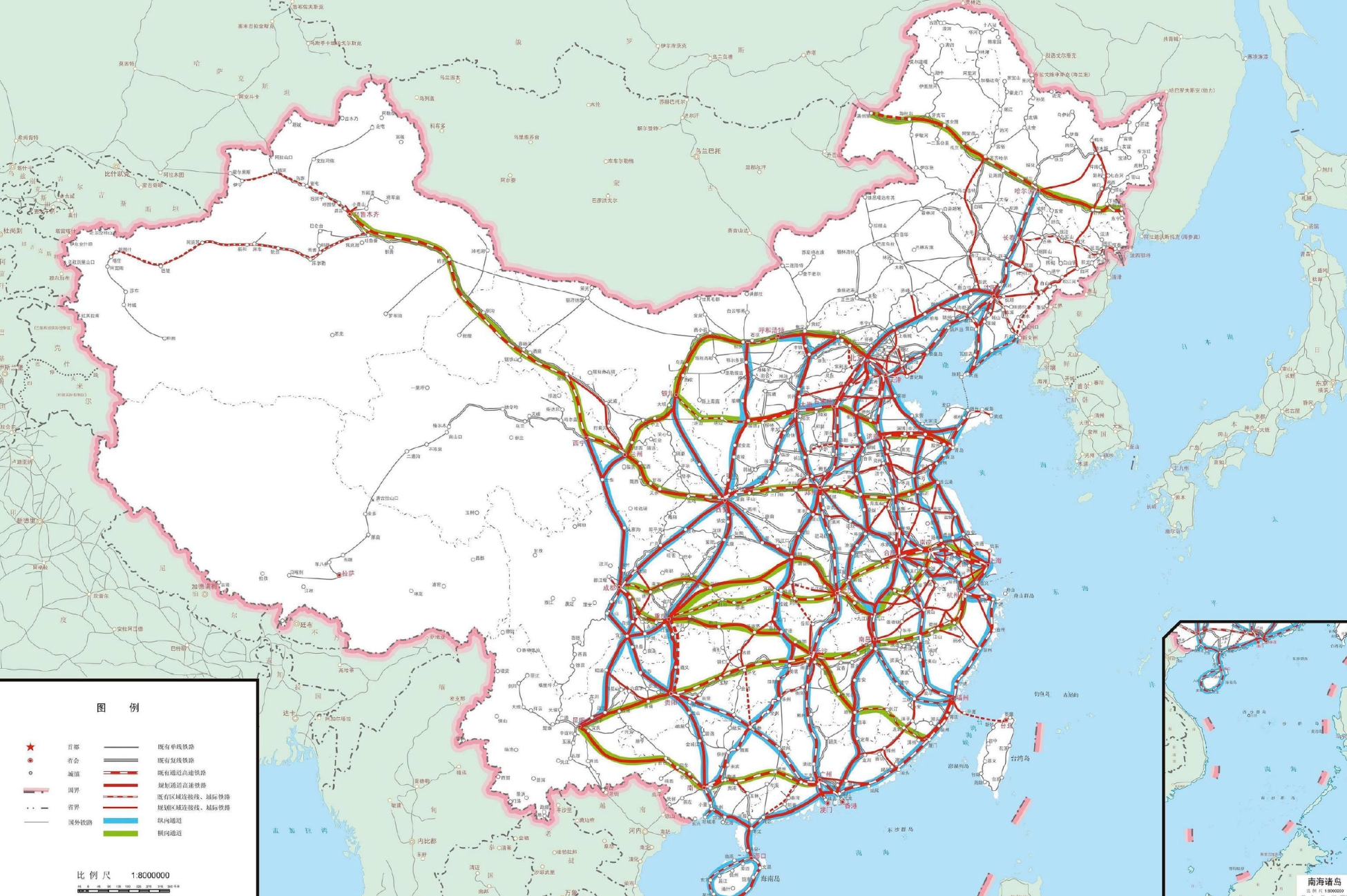
 Transport and traffic
 Railway
Xinjiang Uygur Zizhiqu-XJ
Yunnan Sheng-YN
Zhejiang Sheng-ZJ
Railway
Xinjiang Uygur Zizhiqu-XJ
Yunnan Sheng-YN
Zhejiang Sheng-ZJ
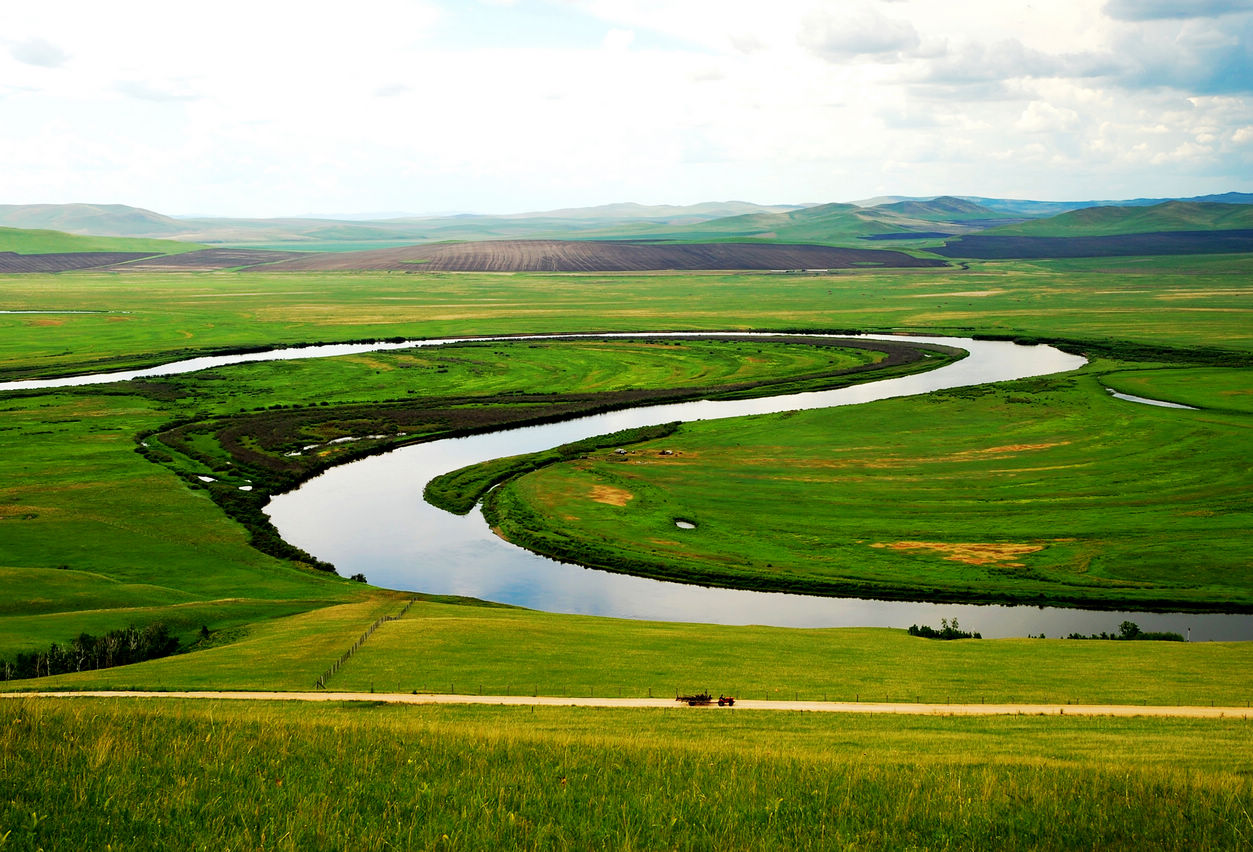
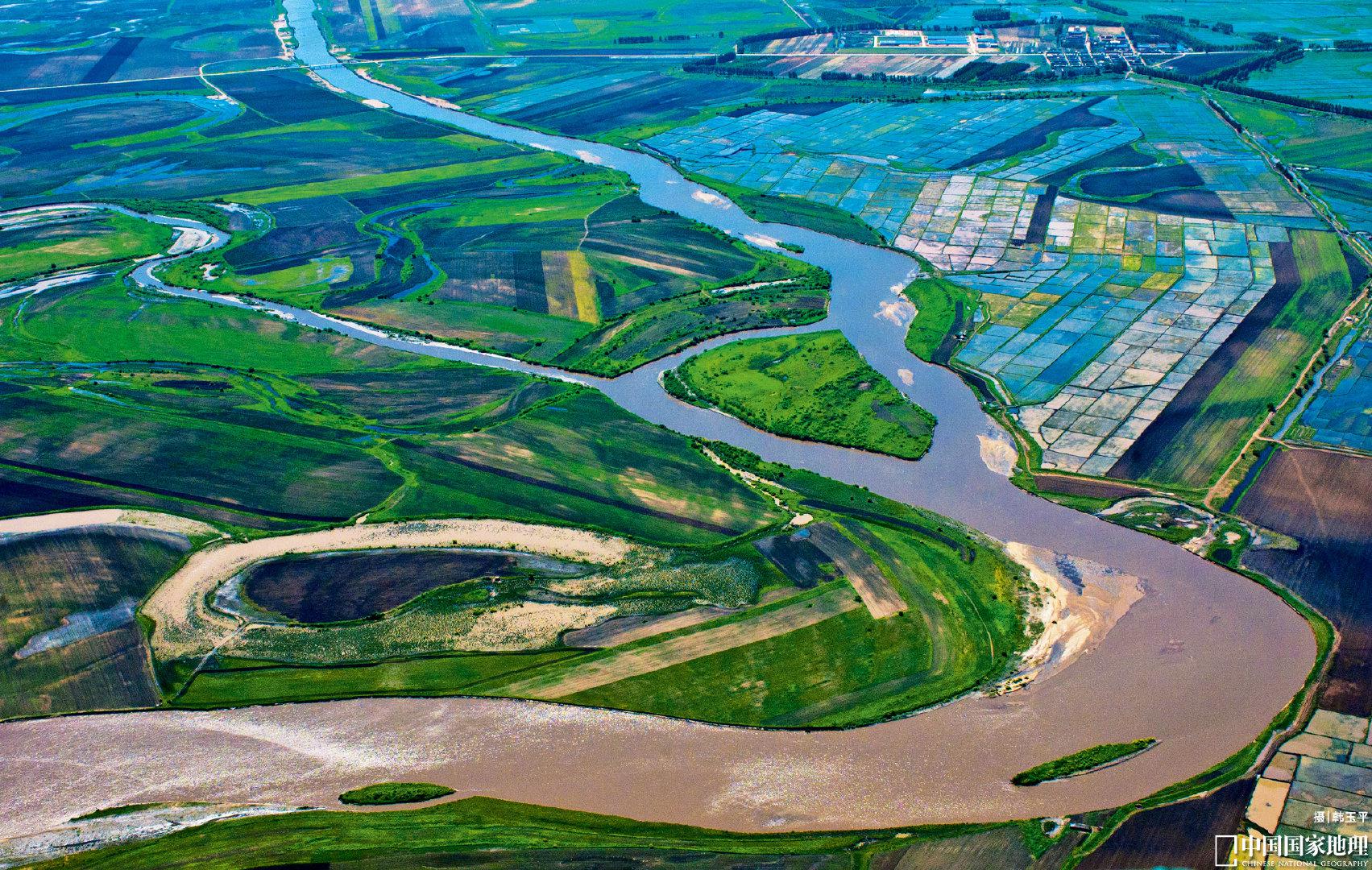
Der Argun bzw. Ergun (burjatisch für „breiter Fluss“; russisch Аргунь/Argun; chinesisch 額爾古納河 / 额尔古纳河, Pinyin E'erguna He) ist der etwa 1620 km lange rechte, d. h. südliche Quellfluss des Amur (Heilong Jiang) in Nordost-China (Asien).
额尔古纳河[a](蒙古语:ᠡᠷᠬᠥᠨᠠ
ᠭᠣᠣᠯ,西里尔字母:Эргүнэ гол;布里亚特语:Үргэнэ гол,罗马化:Ürgene gol),清代也作额尔古讷河(满语:ᡝᡵᡤᡠᠨᡝ
ᠪᡳᡵᠠ,穆麟德转写:ergune bira),俄罗斯称阿尔贡河(俄语:река́ Аргу́нь,罗马化:reká Argúnʹ),是位于中国内蒙古自治区呼伦贝尔盟和俄罗斯联邦外贝加尔边疆区之间的一条河流,自南偏西流向北偏东,蜿蜒在呼伦贝尔草原上。额尔古纳河和俄罗斯境内的石勒喀河交汇后形成黑龙江。
Beijing Shi-BJ
China
Guangdong Sheng-GD
Hebei Sheng-HE
Heilongjiang Sheng-HL
Henan Sheng-HA
Hubei Sheng-HB
Jiangxi Sheng-JX
Jilin Sheng-JL
Nei Mongol Zizhiqu-NM

 Eat and Drink
 Companies
 Agriculture, forestry, livestock, fishing
 Animal world
China
Democratic People's Republic of Korea
Animal world
China
Democratic People's Republic of Korea
 Geography
Mountains in Asia
Geography
Vulcan
Heilongjiang Sheng-HL
Jilin Sheng-JL
Liaoning Sheng-LN
Geography
Mountains in Asia
Geography
Vulcan
Heilongjiang Sheng-HL
Jilin Sheng-JL
Liaoning Sheng-LN
 Ski vacation
China
Ski vacation
China
长白山(满语:ᡤᠣᠯᠮᡳᠨ
ᡧᠠᠩᡤᡳᠶᠠᠨ
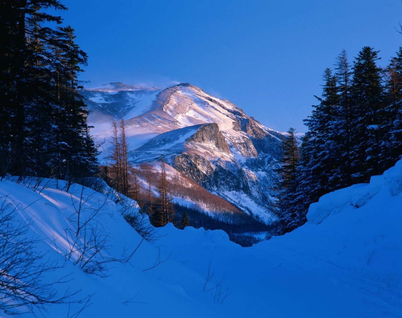
ᠠᠯᡳᠨ,穆麟德:Golmin Šanggiyan Alin,太清:Golmin Xanggiyan Alin),古名不咸山(或为白罗聂·显干之音译)、太白山,在朝鲜半岛称白头山(朝鲜语:백두산/白頭山),是位于中华人民共和国和朝鲜民主主义人民共和国边境的界山。广义的长白山是指一条西南-东北走向绵延上千千米的一系列山脉,横亘于中国吉林、辽宁、黑龙江三省的东部及北朝鲜两江道交界处。狭义上的长白山则单指其主峰长白山,是一座休眠的活火山,在清朝时曾多次喷发。主峰白头峰最高点位于火山臼形成的天池南部的朝鲜民主主义人民共和国境内,天池位于中国和北朝鲜的边界上,在中国部分,分属吉林省白山市抚松县与延边朝鲜族自治州安图县。它实际上是一个相当宽阔的环形火山口(山体相对高度1600米左右,而山体宽度则达十几千米),火山口当中为天池。 由于是中国东北最高峰,长白山在多个中国北方民族的神话传说中都被视为“神山”及朝鲜族的发祥地。长白山是大清龙脉,龙兴之地,是满族祖先世世代代居住的地方,这是一块风水宝地。
Das Gebiet Changbai Shan erstreckt sich über fast 1.000 km entlang der chinesisch – nordkoreanischen Grenze. Ein Großteil dieses Gebirges wurde 1961 zum Naturschutzgebiet erklärt. Die Gipfel erreichen Höhen über 2.500 m, der höchste Berg ist der Baitou Shan, was so viel bedeutet wie Weißkopf-Berg. Sein Gipfel erreicht eine Höhe von 2.744 m. Das Changbai Shan – Gebirge hat mit dem Baitou Shan die höchste Erhebung des ost-asiatischen Kontinents. Das Klima ist hier sehr rau, die Jahresdurchschnittstemperatur liegt gerade mal bei 3 – 7 Grad. Das ehemals vulkanisch aktive Gebiet besitzt einen sehr schönen Kratersee. Durch Ihn verläuft die Grenze zu Nordkorea. Das gesamte Gebiet wurde im Jahre 1980 unter den Schutz der UNESCO gestellt. Zu erreichen ist die Gegend im Norden des Landes am besten mit dem Zug, Endstation der Bahnlinie zum Changbai Chan ist das kleine Dorf Baihe.(Quelle:http://www.reise-ziele-online.de)
Der Paektusan (kor. Weißkopf-Berg), chinesisch Changbai Shan (immerweißer Berg) oder Baitou Shan genannt, ist die höchste Erhebung des Changbai-Gebirges an der Grenze zwischen der Volksrepublik China und Nordkorea. Die Angaben zur Höhe variieren je nach Quelle zwischen 2744 und 2750 Metern.
Der Berg liegt an der Grenze zwischen der nordkoreanischen Provinz Ryanggang-do und der chinesischen Provinz Jilin. Er ist der höchste Berg der Mandschurei, der Koreanischen Halbinsel und Nordkoreas. Auf dem Berg entspringen die Flüsse Songhua, Tumen und Yalu.
白頭山[1](はくとうさん・朝鮮名:ペクトサン)は、朝鮮民主主義人民共和国(北朝鮮)両江道と中華人民共和国(中国)吉林省の国境地帯にある標高2,744mの火山。別名、長白山[2](ちょうはくさん)。
中国吉林省と北朝鮮両江道の国境地帯にあるこの山は、古くは「不咸山」「白山」「太白山」と呼ばれた[要出典]。このうち「白山」「太白山」は中国でも朝鮮でも後世までこの山の別名としても使われた。李氏朝鮮の時代には「太白山」と呼んでいた。現在北朝鮮と大韓民国(韓国)が用いている白頭山という名称の起源は不明である。
満州民族の満州語ではゴルミン・シャンギャン・アリン(満州文字:ᡤᠣᠯᠮᡳᠨ
ᡧᠠᠩᡤᡳᠶᠠᠨ
ᠠᠯᡳᠨ、転写:golmin šanggiyan alin、漢字音写:果勒敏珊延阿林、意は「どこまでも白い山」)と金の時代より使われ始めた。 清朝では長白山(ちょうはくさん。中国語: 簡体字中国語: 长白山; 繁体字: 長白山、チャンパイシャン、Chángbáishān)と漢訳され定着している。
Paektu Mountain (Korean: 백두산, 白頭山), also known as Baekdu Mountain and in China as Changbai Mountain (simplified Chinese: 长白山; traditional Chinese: 長白山), is an active stratovolcano on the Chinese–North Korean border.[3] At 2,744 m (9,003 ft), it is the highest mountain of the Changbai and Baekdudaegan ranges. Koreans assign a mythical quality to the volcano and its caldera lake, considering it to be their country's spiritual home.[4] It is the highest mountain in Korea and Northeast China.[5]
A large crater lake, called Heaven Lake, is in the caldera atop the mountain. The caldera was formed by the VEI 7 "Millennium" or "Tianchi" eruption of 946, which erupted about 100–120 km3 (24–29 cu mi) of tephra. This was one of the largest and most violent eruptions in the last 5,000 years (alongside the Minoan eruption, the Hatepe eruption of Lake Taupo in around AD 180, the 1257 eruption of Mount Samalas near Mount Rinjani and the 1815 eruption of Tambora).
The mountain plays an important mythological and cultural role in the societies and civil religions of both contemporary Korean states. For instance, it is mentioned in both of their national anthems and is depicted on the national emblem of North Korea.
Le mont Paektu ou mont Changbai en Chine est le point culminant de l'ensemble de la Corée, à 2 744 mètres d'altitude. C'était un mont sacré pour les Coréens et les Mandchous. En 946, il a été le théâtre d'une des plus fortes éruptions de notre ère. Sa partie chinoise est protégée par la réserve naturelle du mont Changbai qui a été reconnue réserve de biosphère en 1979, et sa partie nord-coréenne par la réserve naturelle du mont Paektu, réserve de biosphère depuis 1989 (1 320 km2). Situé dans une zone inhospitalière, ses abords sont relativement peu peuplés.
Il Monte Paektu, anche noto come Baitou (in cinese 白頭山T, 白头山S, BáitóushānP) e Baekdu (백두산?, 白頭山?, PaektusanMR), è il picco più alto della penisola coreana (2.744 m), al confine fra la Corea del Nord e la Cina. Il suo nome cinese è Changbai (長白山T, 长白山S, ChángbáishānP), da cui il nome della catena montuosa a cui appartiene, il Changbai Shan.
El monte Paektu (en chosŏn'gŭl, 백두산; en hancha, 白頭山; romanización revisada del coreano, Baektu-san; McCune-Reischauer, Paektu-san), también conocido como montaña Changbai en China, es una montaña volcánica localizada en la frontera entre Corea del Norte y China. Con 2744 m, es la montaña más alta de la montañas Changbai, al norte, y de la cordillera Baekdudaegan, al sur. También es la montaña más alta de la península de Corea y de Manchuria.
Пэктуса́н[2][3], также Байтоушань[2][3] (кор. 백두산) или Чанбайша́нь (кит. 长白山) — потенциально активный вулкан на границе КНДР (провинция Янгандо) и КНР (провинция Цзилинь). Гора имеет высоту 2744 м (2750 м[2]) и является высшей точкой Маньчжуро-Корейских гор, а также всей Маньчжурии и Корейского полуострова[4].