
Deutsch-Chinesische Enzyklopädie, 德汉百科
 Chile
Chile

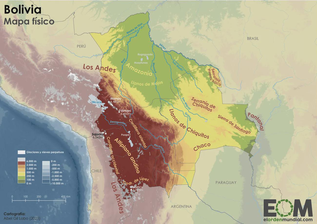
Der Altiplano (auf Quechua und Aymara Qullaw) ist eine abflusslose Hochebene in Südost-Peru und West-Bolivien zwischen den Hochgebirgsketten der West-Anden (Cordillera Occidental) und der Ost-Anden (Cordillera Oriental).
阿尔蒂普拉诺高原(西班牙语:Altiplano,意为高地平原)也称为玻利维亚高原,位于南美洲中部安第斯山脉最宽广处,是世界上继青藏高原之后的又一片平均海拔超过3,000米的大高原,南美洲最大湖的的喀喀湖是其最为著名的地理特色。
阿尔蒂普拉诺高原是位于安第斯山脉中部的内流盆地,地跨智利、阿根廷、玻利维亚、秘鲁和厄瓜多尔。平均海拔约3,300米(11,000英尺),略逊于青藏高原。但与青藏高原不同的是,阿尔蒂普拉诺高原是以高原西部中央火山地带的大规模活火山为主。高原的西南部是地球最干燥的地区之一的阿塔卡马沙漠,与之相反,东部却是湿润的亚马逊雨林。

 Alaska-AK
 Argentina
 Bolivia

 British Columbia-BC

 California-CA
 Chile
Chile
 Columbia
 Costa Rica
 Ecuador
 Guatemala
 Honduras
 Canada
 Mexico

 Nevada-NV
 Nicaragua

 Oregon-OR
 Panama
 Peru
Peru
 Venezuela
 United States

 Washington-WA

科迪勒拉山系(American Cordillera) 纵贯美洲大陆西部的山系,北起阿拉斯加,南至智利火地岛,绵延约1.5万公里,为世界最长的山系。“科迪勒拉”(Cordillera)在西班牙语中意为“山脉”。
科迪勒拉山系由一系列山脉、山间平原和盆地组成,山脉除个别地段外,总体呈南-北或西北-东南走向,北美部分较宽,一般海拔1500-4000米,南美部分较窄,大部在海拔3000米以上,有高山冰川,多火山、地震。
包含阿拉斯加山脉、落基山脉、安第斯山脉等。科迪勒拉山系最高峰阿空加瓜山,海拔6962米。科迪勒拉山系构成环太平洋地震带的东半部分。
Die Amerikanischen Kordilleren (spanisch cordillera „Gebirgskette“) sind eine Kette von Kordilleren, die sich im Westen Nord- und Südamerikas erstreckt.
Mit einer Länge von 15.000 Kilometern (Breite bis zu 2.500 Kilometer) stellen sie das längste Faltengebirge der Welt dar; es reicht von Alaska bis Feuerland. Eng verbunden sind die Kordilleren mit dem Pazifischen Feuerring, dessen Ostteil sie bilden: Viele der hohen Gipfel sind Vulkane, ganze Ketten sind vom Vulkanismus geprägt. Das Gebirgssystem entstand durch die Subduktion der Farallon-Platte (einschließlich ihrer heutigen Überreste Cocos- und Nazca-Platte) unter die Nordamerikanische, die Karibische und die Südamerikanische Platte.
科迪勒拉山系(英语:American Cordillera;西班牙语:cordillera Americana)是世界上最长的山系,其山脉位于南北美洲大陆西部,北起阿拉斯加,南到火地岛,绵延约15000公里。属中新生代褶皱带。
アメリカ山系(アメリカさんけい、英語:American Cordillera)とは、北アメリカ、南アメリカ、西南極においてそれぞれ西部の「背骨」を形成する複数の山脈がほとんど連続して繋がっている山系である[1]。環太平洋火山帯の東半分を構成する火山弧の山脈でもある。コルディレラ山系、またはコルディエラ山系とも。
この並行し重なり合うアメリカ山系を北方から順に見ていくと、まずアラスカ州のアラスカ山脈とブルックス山脈(英語版)から始まり、カナダのユーコン準州を抜けてブリティッシュコロンビア州へと至る。続くロッキー山脈のメインベルトは並行するコロンビア山脈(英語版)や太平洋海岸山脈などの山々とともにブリティッシュコロンビア州とバンクーバー島を通過していく。アメリカ合衆国に入ると、山系の支脈はロッキー山脈やシエラネバダ山脈、カスケード山脈、さらに様々で小さい太平洋岸山系の一部も含む。メキシコでは、バハ・カリフォルニア半島の山脈と並行しながらシエラ・マドレ・オクシデンタルやシエラ・マドレ・オリエンタル(英語版)として続く。
メキシコより北の山系はまとめて北アメリカ山系(英語版)と呼ばれている。山系の別の表現として、アメリカやメキシコにおいては「北アメリカの西側の山系」、カナダにおいては「カナダ山系」または「太平洋山系」といった呼称がある。
山系はその後、グアテマラ、ホンジュラス、ニカラグア、コスタリカ、そしてパナマの順に中央アメリカにあたる地域を抜けていき、南アメリカのアンデス山脈となる。アンデス山脈とそれに並行する山々、そしてチリ沖の列島は、コロンビア、ベネズエラ、エクアドル、ペルー、ボリビア、アルゼンチンを通過し、チリにある南アメリカ最南端の地ティエラ・デル・フエゴへと至る。最後はスコシア海のスコシア弧(英語版)を経て、南極半島の山脈へ到達し終わる[2]。
The American Cordillera is a chain of mountain ranges (cordilleras) that consists of an almost continuous sequence of mountain ranges that form the western "backbone" of North America, South America and Central America.[1] It is also the backbone of the volcanic arc that forms the eastern half of the Pacific Ring of Fire.
La cordillère américaine est un enchaînement montagneux quasi-ininterrompu qui constitue l'épine dorsale occidentale des Amériques jusqu'en Antarctique ainsi que de l'arc volcanique formant la moitié orientale de la ceinture de feu du Pacifique.
Du nord au sud, elle commence par la chaîne Brooks et la chaîne d'Alaska, puis se poursuit à travers les Territoires du Nord-Ouest et le Yukon par les monts Mackenzie, tandis que côté Pacifique elle est constituée par la chaîne Saint-Élie dont un versant occupe une partie de l'Alaska côtière, l'autre étant implanté au Yukon. Ces deux formations traversent ensuite la Colombie-Britannique, l'une constituant à l'intérieur des terres la chaîne principale des montagnes Rocheuses, doublée de la chaîne Columbia, et l'autre formant à l'ouest les chaînes côtières du Pacifique.
Aux États-Unis, elle inclut le tronc entier des Rocheuses d'une part, les Cascades et la Sierra Nevada d'autre part, auxquelles s'ajoutent les chaînes côtières des États de Washington, de l'Oregon et de la Californie. Au Mexique, elle devient la Sierra Madre orientale et la Sierra Madre occidentale ainsi que les montagnes dorsales de la péninsule de Basse-Californie. Plus au sud, la Sierra Madre del Sur assure sur la côte occidentale la continuité du système, tandis qu'au centre c'est la Sierra Madre de Oaxaca qui joue ce rôle.
La cordillère se poursuit en Amérique centrale par la Sierra Madre de Chiapas au Guatemala, Salvador et Honduras, puis par une succession de chaînes plus courtes à travers le Nicaragua, le Costa Rica (dont la cordillère de Talamanca et la cordillère Centrale) et le Panama. En Amérique du Sud, elle devient la cordillère des Andes. Cette dernière avec ses chaînes parallèles (essentiellement les cordillères Orientale, Centrale et Occidentale), continue à travers le Venezuela, la Colombie, l'Équateur, le Pérou, la Bolivie, le Chili (où elle inclut les îles côtières) et l'Argentine pour atteindre la Terre de Feu (Andes fuégiennes, dont la cordillère Darwin). Elle se poursuit par la chaîne de Géorgie du Sud et les îles Shetland du Sud à travers l'océan Austral jusqu'aux montagnes de la Terre de Graham.
Cette vaste cordillère culmine en Argentine à 6 962 mètres d'altitude à l'Aconcagua.
La Cordigliera Americana è un'estesa e quasi continua serie di catene montuose (in lingua spagnola cordillera) che si sviluppano lungo il fianco occidentale dell'America settentrionale, centrale e meridionale, lungo il versante rivolto verso l'Oceano Pacifico.[1] È anche la spina dorsale dell'arco vulcanico che costituisce la parte orientale della cintura di fuoco del Pacifico e si può considerare che la sua continuazione ideale sia rappresentata dalle isole della Georgia del Sud e Isole Sandwich Australi, per proseguire poi nella Terra di Graham della Penisola Antartica.[2]
La cordillera Americana es una extensa cadena montañosa que consiste en una casi continua secuencia de cordilleras y sierras, a lo largo de todo el oeste del continente americano, llegando hasta la Antártida
De norte a sur, esta secuencia orogénica en sentido meridiano, comienza con la cordillera de Alaska y la cordillera Brooks en Alaska. Se extiende a través del Yukón y la Columbia Británica en Canadá. En Estados Unidos de América la rama principal son las Montañas Rocosas, en México la cordillera continúa a través de la Sierra Madre Occidental y la Sierra Madre Oriental. Luego continúa a través de las sierras de Centroamérica en Guatemala, El Salvador, Honduras, Nicaragua, Costa Rica y Panamá. Finalmente se convierte en la cordillera de los Andes en América del Sur. Además, se considera que puede continuar hasta las islas Georgias del Sur y a través del Atlántico Sur hasta las montañas de la Tierra de Graham en la península Antártica. Este sistema orogénico, es la mitad oriental del Anillo del Fuego del océano Pacífico.
Кордилье́ры (исп. Cordilleras, англ. American Cordillera) — величайшая по протяжённости горная система земного шара, простирающаяся вдоль западных окраин Северной Америки, от 66° с. ш. (Аляска) до 56° ю. ш. (Огненная Земля).
Вся система Кордильер делится на две части — Кордильеры Северной Америки и Кордильеры Южной Америки, или Анды.
Длина — более 18 тыс. км, ширина — до 1600 км в Северной Америке и до 900 км в Южной. Кордильеры расположены на территории Канады, США, Мексики, государств Центральной Америки, Венесуэлы, Колумбии, Эквадора, Перу, Боливии, Аргентины и Чили. Почти на всём протяжении являются водоразделом между бассейнами Атлантического и Тихого океанов, а также резко выраженной климатической границей.
По высоте Кордильеры уступают только Гималаям и горным системам Центральной Азии. Наиболее высокие вершины: в Северной Америке — гора Денали (прежнее название — Мак-Кинли; 6190 м), в Южной Америке — гора Аконкагуа (6961 м[1]).
Кордильеры лежат во всех географических поясах Америки (кроме субарктического и арктического) и отличаются большим разнообразием ландшафтов и ярко выраженной высотной поясностью. Снеговая граница на Аляске — на высоте 600 метров, на Огненной Земле — 500—700 метров, в Боливии и Южном Перу поднимается до 6000—6500 метров. В северо-западной части Кордильер Северной Америки и на юго-востоке Анд ледники спускаются до уровня океана, в жарком поясе они покрывают лишь наиболее высокие вершины. Общая площадь оледенений — около 90 тыс. км² (в Кордильерах Северной Америки — 67 тыс. км², в Андах — около 20 тыс. км²).

安第斯山脉(西班牙语:Cordillera de los Andes;奇楚亚语:Walla Antikuna),也称安弟斯山脉或安蒂斯山脉,是陆地上最长的山脉,位于南美洲的西岸,约7,000公里长,200至700公里宽(最宽的部分在南纬18度到20度之间),平均高度约4,000米,由北到南经过委内瑞拉、哥伦比亚、厄瓜多尔、秘鲁、玻利维亚、智利及阿根廷等国。
安第斯山脉由于其中的地形凹陷,可以分为几个不同的区域。安第斯山脉中有几个高原,其中也有一些大城市,例如基多、波哥大、阿雷基帕、麦德林、苏克雷、梅里达市和拉巴。阿尔蒂普拉诺高原是世界第二大的高原,仅次于亚洲的青藏高原。安第斯山脉依气候可分为三区:热带安第斯、乾安地斯及湿安第斯。
安第斯山脉最高峰是位在阿根廷境内的阿空加瓜山,高度6,962米,是美洲第一高峰,也是世界第一高的火山。因为地球自转产生的赤道隆起,赤道位置的地球半径会较其他地方要大,因此位于赤道附近的钦博拉索山是地表离地心最远的位置。世界最高的火山在安第斯山脉,包括高度为6,893米的奥霍斯-德尔萨拉多山,另外在安第斯山脉有五十座火山的高度超过6,000米。安第斯山脉中的图蓬加托火山是世界上最高的活火山,海拔约6,600米。
Die Anden (spanisch Cordillera de los Andes, Quechua Anti bzw. Antis) sind die längste (über dem Meeresspiegel befindliche) Gebirgskette der Erde und das höchste Gebirge außerhalb Asiens. Sie bilden den Südteil der Amerikanischen Kordilleren, die in Mittelamerika orographisch unterbrochen sind.
Sie erstrecken sich entlang der Westküste Südamerikas von Venezuela über Kolumbien, Ecuador, Peru, Bolivien, Argentinien und Chile. Mit einer Nord-Süd-Ausdehnung von 7500 Kilometern von den Tropen (bei 10° Nord) bis weit in die Außertropen (bei 55° Süd) übertreffen sie die Rocky Mountains Nordamerikas (4800 km) um etwa die Hälfte und haben fast die doppelte Ausdehnung des Himalaya-Karakorum-Hindukusch-Systems in Asien mit seinen 4400 Kilometern. Im Süden und in Ecuador sind sie bis 200 km breit. Zwischen Arica (Chile) und Santa Cruz de la Sierra (Bolivien) beträgt die Ost-West-Ausdehnung über 600 Kilometer.
アンデス山脈(アンデスさんみゃく、スペイン語: Cordillera de los Andes)は、主に南アメリカ大陸の西側に沿って、北緯10度から南緯50度まで南北7500km、幅750kmにわたる世界最長の連続した褶曲(しゅうきょく)山脈である。山脈はベネズエラ、コロンビア、エクアドル、ペルー、ボリビア、アルゼンチン、チリの7カ国にまたがる。 最高峰はアコンカグア(6960m・一説には7021m)で、6000mを越える高峰が20座以上そびえ立っている。山脈が現在の姿になり始めたのは白亜紀で、その後現在まで太平洋プレート、ナスカプレートと南米大陸のぶつかり合いで隆起し、場所により異なる構造運動を受けて大きくなったと考えられている。
The Andes, Andes Mountains or Andean Mountains (Spanish: Cordillera de los Andes) are the longest continental mountain range in the world, forming a continuous highland along the western edge of South America. The range is 7,000 km (4,300 mi) long, 200 to 700 km (120 to 430 mi) wide (widest between 18° south and 20° south latitude), and has an average height of about 4,000 m (13,000 ft). The Andes extend from north to south through seven South American countries: Venezuela, Colombia, Ecuador, Peru, Bolivia, Chile, and Argentina.
Along their length, the Andes are split into several ranges, separated by intermediate depressions. The Andes are the location of several high plateaus—some of which host major cities such as Quito, Bogotá, Cali, Arequipa, Medellín, Bucaramanga, Sucre, Mérida and La Paz. The Altiplano plateau is the world's second-highest after the Tibetan plateau. These ranges are in turn grouped into three major divisions based on climate: the Tropical Andes, the Dry Andes, and the Wet Andes.
The Andes Mountains are the highest mountain range outside Asia. The highest mountain outside Asia, Argentina's Mount Aconcagua, rises to an elevation of about 6,961 m (22,838 ft) above sea level. The peak of Chimborazo in the Ecuadorian Andes is farther from the Earth's center than any other location on the Earth's surface, due to the equatorial bulge resulting from the Earth's rotation. The world's highest volcanoes are in the Andes, including Ojos del Salado on the Chile-Argentina border, which rises to 6,893 m (22,615 ft).
The Andes are also part of the American Cordillera, a chain of mountain ranges (cordillera) that consists of an almost continuous sequence of mountain ranges that form the western "backbone" of North America, Central America, South America and Antarctica.
La cordillère des Andes, en espagnol Cordillera de los Andes, est la plus longue chaîne de montagnes continentale du monde2, orientée nord-sud tout le long de la côte occidentale de l'Amérique du Sud. Longue d'environ 7 100 kilomètres, large de 200 à 800 kilomètres (entre le 18 et le 20° de latitude Sud), la cordillère a une altitude moyenne de 4 000 mètres et culmine à 6 962 mètres. Elle débute au Venezuela au nord puis traverse la Colombie, l'Équateur, le Pérou, la Bolivie, le Chili et l'Argentine, jusqu'à la pointe sud du continent.
Les Andes sont la plus haute chaîne de montagnes d'Amérique. Le sommet le plus élevé est l'Aconcagua, avec ses 6 962 mètres d'altitude1, situé en Argentine. Le faîte du volcan Chimborazo dans les Andes équatoriennes, est le point le plus éloigné du centre de la Terre, en raison du renflement du globe au niveau de l'équateur. Plusieurs volcans sont présents, figurant parmi les plus hautes montagnes sur Terre après celles d'Asie et dépassant 6 000 mètres d'altitude.
La cordigliera delle Ande (in spagnolo Cordillera de los Andes) è un'importante catena montuosa dell'America meridionale, situata nella parte più occidentale del continente, attraversando sette stati: Venezuela, Colombia, Ecuador, Perù, Bolivia, Cile e Argentina, alcuni dei quali sono noti come Paesi andini: rappresenta il settore meridionale della più estesa Cordigliera Americana che, partendo dall'Alaska, costeggia l'intero versante rivolto verso l'Oceano Pacifico dell'intero continente americano e che termina alla Terra del Fuoco.
Formata principalmente da due grandi settori: la Cordillera Oriental e la Cordillera Occidental, in gran parte separati da una profonda depressione intermedia, in cui sorgono altre catene di importanza minore, la principale delle quali è Cordillera de la Costa cilena (altre piccole catene sorgono ai lati delle grandi catene), è anche la più alta catena montuosa al di fuori del continente asiatico, toccando i 6962 m sopra il livello del mare con la cima più alta, l'Aconcagua, mentre la vetta del vulcano Chimborazo, nelle Ande ecuadoriane, è il punto della superficie terrestre più lontano dal centro della Terra a causa del rigonfiamento equatoriale.
Con i suoi 7200 km di lunghezza (dall'istmo di Panama, a nord, fino a Capo Horn, a sud) è tradizionalmente considerata la catena montuosa più lunga del mondo[1], rappresentando l'ideale prosecuzione verso sud delle catene montuose dell'America nord-occidentale e centrale, la sua larghezza media è invece di 240 km, toccando nel punto più esteso i 500 km (fra il 18º e il 20º parallelo sud), mentre l'altezza media è di circa 4000 m.
А́нды, А́ндские Кордилье́ры (исп. Andes; Cordillera de los Andes) — одна из самых длинных (9000 км)[1] и одна из самых высоких (гора Аконкагуа, 6961 м)[2] горных систем Земли, окаймляющая с севера и запада всю Южную Америку; южная часть Кордильер. Местами Анды достигают ширины свыше 500 км (наибольшая ширина — до 750 км — в Центральных Андах, между 18° и 20° ю. ш.)[3]. Средняя высота — около 4000 м.
Анды являются крупным межокеанским водоразделом; к востоку от Анд текут реки бассейна Атлантического океана (в Андах берут начало сама Амазонка и многие её крупные притоки, а также притоки Ориноко, Парагвая, Параны, река Магдалена и реки Патагонии), к западу — реки бассейна Тихого океана (преимущественно короткие).
Анды служат важнейшим в Южной Америке климатическим барьером, изолирующим территории к западу от Главной Кордильеры от влияния Атлантического океана, к востоку — от влияния Тихого океана. Горы лежат в 5 климатических поясах (экваториальном, субэкваториальном, тропическом, субтропическом и умеренном) и отличаются (особенно в центральной части) резкими контрастами в увлажнении восточных (подветренных) и западных (наветренных) склонов.
В силу значительной протяжённости Анд отдельные их ландшафтные части значительно отличаются друг от друга. По характеру рельефа и другим природным отличиям, как правило, выделяют три основных региона — Северные, Центральные и Южные Анды.
Анды протянулись через территории семи государств Южной Америки — Венесуэлы, Колумбии, Эквадора, Перу, Боливии, Чили и Аргентины.


 Asia-Pacific Economic Cooperation,APEC
 Chile
Chile

 Hand in Hand

 Party and government

 Party and government
 Asia-Pacific Economic Cooperation,APEC


 Asia-Pacific Economic Cooperation,APEC

 Australian Capital Territory-ACT
 Australia
 Beijing Shi-BJ

 British Columbia-BC
 Brunei Darussalam
 Chile
Chile
 China
China

 Hand in Hand

 Hawaii-HI
 Hongkong Tebiexingzhengqu-HK
 Indonesia
 Japan
Japan
 Canada
 Kantō
Kantō
 Kinki
Kinki
 Malaysia
 Mexico
 New Zealand

 New South Wales-NSW
 Papua-Neuguinea

 Party and government

 Party and government
 Asia-Pacific Economic Cooperation,APEC
 Peru
Peru
 Philippines
 Republic of Korea
 Russia
 Shanghai Shi-SH
 Singapore
 Taiwan Sheng-TW
 Thailand
 United States
 Vietnam

 Washington-WA

 Important International Organizations

亚太经济合作组织(简称亚太经合组织;英语:Asia-Pacific Economic Cooperation,缩写:APEC),是亚太区内各地区之间促进经济成长、合作、贸易、投资的论坛。此组织的创办在历史上取代了该区域的冷战结构,但由于日本在该区域会因过去历史记忆引发负面评价,所以由澳大利亚主导创始事项[1]。
始设于1989年,现有21个经济体成员。亚太经合组织是经济合作的论坛平台,其运作是通过非约束性的承诺与成员的自愿,强调开放对话及平等尊重各成员意见,不同于其他经由条约确立的政府间组织。“APEC”与“Asia-Pacific Economic Cooperation”均是亚太经济合作组织的注册商标。[2]
Die Asiatisch-Pazifische Wirtschaftsgemeinschaft (für englisch Asia-Pacific Economic Cooperation, kurz APEC, auch übersetzt als Asiatisch-Pazifische Wirtschaftskooperation oder Asien-Pazifik-Forum) ist eine internationale Organisation, die es sich zum Ziel gesetzt hat, im pazifischen Raum eine Freihandelszone einzurichten.
In den 21 APEC-Staaten lebt knapp die Hälfte der Weltbevölkerung. Der Wirtschaftsraum erbringt mehr als die Hälfte der Weltwirtschaftsleistung und ist eine der am schnellsten wachsenden Wirtschaftsregionen der Welt.
アジア太平洋経済協力会議(アジアたいへいようけいざいきょうりょくかいぎ、英: Asia-Pacific Economic Cooperation)は、環太平洋地域における多国間経済協力を進めるための非公式なフォーラム[2]である。略称、APEC(エイペック[3][4])。
「アジア太平洋」という概念が最初に打ち出されたのは、永野重雄が1967年に発足させた太平洋経済委員会(PBEC)という経済団体の設立時であるとされるが[5][6][7]、具体的にこうした地域概念が政府レベルの協力枠組みに発展する萌芽は、1978年、日本の大平正芳首相が就任演説で「環太平洋連帯構想」を呼びかけたことにある。これを具体化した大平政権の政策研究会「環太平洋連帯研究グループ」(議長:大来佐武郎、幹事佐藤誠三郎)の報告を受け、大平がオーストラリアのマルコム・フレイザー首相に提案して強い賛同を得たことが、1980年9月の太平洋経済協力会議(PECC)の設立につながった。PECCは地域における様々な課題を議論し研究するセミナーといった趣のものであったが、これを土台にして、各国政府が正式に参加する会合として設立されたのが、APECである[8][9]。
APECは、1989年にオーストラリアのホーク首相の提唱で、日本・アメリカ合衆国・カナダ・韓国・オーストラリア・ニュージーランド及び当時の東南アジア諸国連合(ASEAN)加盟6か国の計12か国で発足し、同国のキャンベラで閣僚会議(Ministerial Meeting)を開催した。また、1993年には米国のシアトルで初の首脳会議(Economic Leaders' Meeting)がもたれた。現在は、首脳会議、及び、外相、経済担当相による閣僚会議をそれぞれ年1回開いている。シンガポールに常設事務局を置き、開催国から任期1年で事務局長が選任されている[10]。 参加しているメンバーは、21カ国・地域で、2012年現在、人口では世界の41.4%、GDP(国内総生産)では57.8%、貿易額では47%を占めている。
APECは、開かれた地域協力によって経済のブロック化を抑え、域内の貿易・投資の自由化を通じて、世界貿易機関(WTO)のもとでの多角的自由貿易体制を維持・発展することを目的としてきたが、近年のWTOの新ラウンドの停滞や自由貿易協定締結の動きの活発化などによって、その存在意義が問われている。
Asia-Pacific Economic Cooperation (APEC) is an inter-governmental forum for 21 Pacific Rim member economies[2] that promotes free trade throughout the Asia-Pacific region. Inspired from the success of Association of Southeast Asian Nations (ASEAN)’s series of post-ministerial conferences launched in the mid-1980s, the APEC was established in 1989 in response to the growing interdependence of Asia-Pacific economies and the advent of regional trade blocs in other parts of the world; and to establish new markets for agricultural products and raw materials beyond Europe.[3][4][5] Headquartered in Singapore, the APEC is recognised as one of the oldest forums and highest-level multilateral blocs in the Asia-Pacific region, and exerts a significant global influence.[6][7][8][9][10][11]
An annual APEC Economic Leaders' Meeting is attended by the heads of government of all APEC members except Republic of China (Taiwan) (which is represented by a ministerial-level official under the name Republic of China as economic leader).[12] The location of the meeting rotates annually among the member economies, and a famous tradition, followed for most (but not all) summits, involves the attending leaders dressing in a national costume of the host country. APEC has three official observers: the Association of Southeast Asian Nations Secretariat, the Pacific Economic Cooperation Council and the Pacific Islands Forum Secretariat.[13] APEC's Host Economy of the Year is considered to be invited in the first place for geographical representation to attend G20 meetings following G20 guidelines.[14][15][16][17]
La Coopération économique pour l'Asie-Pacifique (en anglais : Asia-Pacific Economic Cooperation, APEC) est un forum économique intergouvernemental visant à faciliter la croissance économique, la coopération, les échanges et l'investissement de la région Asie Pacifique. Elle se réunit chaque année1.
L'Asia-Pacific Economic Cooperation (APEC), ossia Cooperazione Economica Asiatico-Pacifica, è un organismo nato nel 1989 allo scopo di favorire la cooperazione (o, più in generale, la crescita) economica, il libero scambio e gli investimenti nell'area asiatico-pacifica. Tale area (come suggerisce il logo stesso dell'APEC) coincide non solo con l'Asia Pacifica, ma potenzialmente con l'intero Pacific Rim.
L'APEC ha sede a Singapore, Paese considerato una delle tigri dell'Asia.
Dal punto di vista del diritto internazionale l'APEC si definisce organismo e non organizzazione internazionale perché, essendo composto da economie e non da Stati, è privo di una piena personalità giuridica. Ciò spiega, fra l'altro, come mai possano farne parte contemporaneamente la Cina continentale, Hong Kong e Taiwan, ossia tre realtà che, territorialmente (secondo Pechino e secondo tutti i governi che intrattengono relazioni diplomatiche con Pechino), appartengono a un unico Stato: la Repubblica Popolare di Cina.
APEC (Asia-Pacific Economic Cooperation, en español Foro de Cooperación Económica Asia-Pacífico) es un foro multilateral creado en 1989, con el fin de consolidar el crecimiento y la prosperidad de los países del Pacífico, que trata temas relacionados con el intercambio comercial, coordinación económica y cooperación entre sus integrantes.1
Como mecanismo de cooperación y concertación económica, está orientado a la promoción y facilitación del comercio, las inversiones, la cooperación económica y técnica y al desarrollo económico regional de los países y territorios de la cuenca del océano Pacífico. Fomentando un crecimiento económico inclusivo, equitativo, sustentable e innovador.2
La suma del Producto Nacional Bruto de las veintiuna economías que conforman el APEC equivale al 56 % de la producción mundial, en tanto que en su conjunto representan el 46 % del comercio global.
La APEC no tiene un tratado formal. Sus decisiones se toman por consenso y funciona con base en declaraciones no vinculantes. Tiene una Secretaría General, con sede en Singapur, que es la encargada de coordinar el apoyo técnico y de consultoría. Cada año uno de los países miembros es huésped de la reunión anual de la APEC. La vigésimo novena cumbre se realizó en noviembre de 2017 en Da Nang, Vietnam; y la próxima será en Santiago, Chile.
Азиатско-Тихоокеанское экономическое сотрудничество (АТЭС) (англ. Asia-Pacific Economic Cooperation, APEC) — форум 21 экономики Азиатско-Тихоокеанского региона для сотрудничества в области региональной торговли и облегчения и либерализации капиталовложений.
Целью АТЭС является повышение экономического роста, процветания в регионе и укрепление азиатско-тихоокеанского сообщества. В экономиках-участницах проживает около 40 % мирового населения, на них приходится приблизительно 54 % ВВП и 44 % мировой торговли[1].
 Companies
 Agriculture, forestry, livestock, fishing
 Eat and Drink
 Geography
 International cities
 Energy resource
 Economy and trade