Deutsch-Chinesische Enzyklopädie, 德汉百科

       
German — Chinese
Catalog Xizang Zizhiqu-XZ

雪顿节
http://www.net4info.de/photos/cpg/albums/userpics/10002/Xue20Dun20Jie20.jpg
雪顿节,是西藏藏族人民的重要节日之一,每年藏历七月一日举行,为期四、五天。雪顿是藏语译者,意思是“酸奶宴”,于是雪顿节便被解释为喝酸奶子的节日。 后来逐渐演变成以演藏戏为主,又称“藏戏节”。按藏传佛教格鲁派(黄教)的规定,每年藏历六月十五至七月三十日为禁期,大小寺庙的喇嘛不许外出,以免踩死 小虫,待七月三十日解禁之后方可下山。喇嘛下山时,农牧民拿出酸奶敬献,形成雪顿节。到17世纪下半叶至18世纪初,清朝皇帝册封了五世达赖阿旺·罗桑嘉措和五世班禅罗 桑意希,赐给金册、金印,从此西藏的“政教合一”制度进一步巩固。这时雪顿节开始演出藏戏。达赖喇嘛从布达拉官移居罗布林卡,雪顿节时藏戏班子来到罗布林 卡演唱。届时,拉萨市附近的居民,身着鲜艳的节日盛装,扶老携幼,提上酥油桶,带上酥油茶对来到罗布林卡在繁茂的树荫下,搭起色彩斑斓的帷幕。在花香草肥 的绿茵上,铺上新卡垫、地毯,摆上果品佳肴,席地而坐,边饮边谈,载歌载舞,观看藏戏,享受节日的欢乐。下午,各家开始串帷幕做客,主人向来宾一敬三口干 一杯的“松准聂塔”(酒礼),唱各种不同曲调的劝酒歌。欲罢,客人将酒三口饮完。敬酒声、祝福声、欢笑声此起彼伏。当晚霞染红天际时,人们才踏着暮色离开 林卡。
This image, video or audio may be copyrighted. It is used for educational purposes only. If you find it, please notify us byand we will remove it immediately.
川藏铁路
http://www.net4info.de/photos/cpg/albums/userpics/10002/Sichuan-Tibet-Eisenbahn_.jpg
This image, video or audio may be copyrighted. It is used for educational purposes only. If you find it, please notify us byand we will remove it immediately.
西南地區 西南地区
西南地区(Southwestern China) ,是中国七大自然地理分区之一,包含重庆市、四川省、贵州省、云南省、西藏自治区共五个省区市。四川盆地是该地区人口最稠密、交通最便捷、经济最发达的区域。西南地区北邻西北地区,东临华中地区和华南地区。自然区划概念下的西南地区,主要包括四川盆地、云贵高原、青藏高原南部、两广丘陵西部等地形单元,大致包括重庆、四川、贵州、云南、西藏东部地区、广西西部地区。
http://www.net4info.de/photos/cpg/albums/userpics/10002/Xi20Nan20Di20Qu20.png
This image, video or audio may be copyrighted. It is used for educational purposes only. If you find it, please notify us byand we will remove it immediately.
You do not currently have editing permission, please login !
唐古拉山脉
http://www.net4info.de/photos/cpg/albums/userpics/10002/Tang20Gu20La20Shan20Mai20.jpg
唐古拉山脉(Tanggula Mountains,T'ang-ku-la Shan或Tanggula Shan),位于中国西藏自治区东北部与青海省边境处(青藏高原),东段为西藏青海的界山,东南部延伸接横断山脉云岭怒山。“藏语意为“高原上的山”,又称“当拉山”,在蒙语中意为“雄鹰飞不过去的高山”,是青藏高原中部的一条近东西走向的山脉。
山脉高度在海拔6000米左右,最高峰各拉丹冬海拔6621米,唐古拉山(峰名)6099米。唐古拉山口的海拔虽高达5220米,却因坡缓、高差小而并不显得险要和难以逾越。山峰上发育有小型冰川,为长江澜沧江怒江等河流的发源地。气温低,年平均气温﹣4.4℃(沱沱河站),有多年冻土分布,冻土厚度70—88米,青藏公路经此。植被以高寒草原为主,混生有垫状植物。唐古拉山脉是长江的发源地。也是旅游景点之一。
 
This image, video or audio may be copyrighted. It is used for educational purposes only. If you find it, please notify us byand we will remove it immediately.
You do not currently have editing permission, please login !
扎什伦布寺
 /assets/contentimages/Zha20Shi20Lun20Bu20Si20.jpg
扎什伦布寺意为“吉祥须弥寺”,全名为“扎什伦布白吉德钦曲唐结勒南巴杰瓦林”,意为“吉祥须弥聚福殊胜诸方州”。位于西藏日喀则的尼色日山下。是该地区最大的寺庙。 
明正统12年,宗喀巴弟子根敦主兴建。后四世班禅罗桑却吉坚赞加以扩建。寺中错钦大殿可容2000人诵经,殿中有释迦牟尼像,两边有根敦主与四世班禅立像。大殿两侧为弥勒殿与度母殿。寺的西侧有大弥勒殿,高30米,甚宏伟。另有历世班禅灵塔殿,藏舍利肉身 。寺有四扎仓(经院),教学显密并重。
扎什伦布寺可与达赖的布达拉宫相媲美。它与拉萨的“三大寺”甘丹寺色拉寺哲蚌寺合称藏传佛教格鲁派的“四大寺”。四大寺以及青海的塔尔寺和甘肃的拉卜楞寺并列为格鲁派的“六大寺”。建筑结构也深刻影响了其他藏传佛教建筑如五当召。 
扎什伦布寺是中国著名的六大黄教寺院之一。全国重点文物保护单位之一。 
This image, video or audio may be copyrighted. It is used for educational purposes only. If you find it, please notify us byand we will remove it immediately.
茶马古道/Tea Horse Road
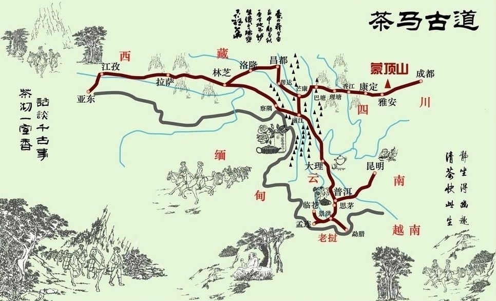
茶马古道,是指唐代以来为顺应当地人民需求,在中国西南和西北地区,以茶叶和马匹为主要交易内容、以马帮为主要运输工具的商品贸易通道,是中国西南民族经济文化交流的走廊。茶马古道是以川藏道、滇藏道与青藏道(甘青道)三条大道为主线,辅以众多的支线、附线,构成的一个庞大的交通网络。地跨陕、甘、贵、川、滇、青、藏,外延达南亚、西亚、中亚和东南亚各国。 茶马古道主要干线主要分南、北两条道,即滇藏道和川藏道。茶马古道的存在推动了各民族经济文化的发展,凝聚了各民族的精神,加强了各民族间的团结。 茶马古道是推动民族和睦、维护边疆安全的团结之道。 茶马古道是中国统一的历史见证,也是民族团结的象征。
http://www.net4info.de/photos/cpg/albums/userpics/10001/Cha20Ma20Gu20Dao20.jpg
 
Die Tee-Pferde-Straße (chinesisch 茶马道, Pinyin Chámǎdào oder 茶马古道, Chámǎgǔdào übersetzt: "Alte Tee-Pferde-Straße") war ein Handelsweg zwischen den chinesischen Provinzen Yunnan (云南) und Sichuan (四川) im Osten und Tibet und Indien im Westen. Manchmal wird sie auch Südliche Seidenstraße genannt. Von den zahlreichen Teerouten, die von den Teeanbaugebieten in diesen beiden Provinzen in alle Himmelsrichtungen führten, hatte sie die größten landschaftlichen Hindernisse zu überwinden. Sie kreuzte mehrere Gebirgskämme von bis zu mehr als 4000 Meter Höhe und mehrere große Flüsse. Acht Monate pro Jahr war sie wegen verschneiter Pässe unterbrochen.
 
茶马古道是指存在于中国西南地区,以马帮为主要交通工具的民间国际商贸通道,是中国西南民族经济文化交流的走廊。茶马古道分川藏线滇藏线两路。 
茶马古道源于古代西南边疆的茶马互市,兴于唐宋,盛于明清,二战中后期最为兴盛。茶马古道分陕甘、陕康藏、滇藏大概路,连接川滇藏,延伸入不丹锡金尼泊尔印度境内,直到抵达西亚西非红海海岸。
茶马古道是可与“丝绸之路”相媲美的中国古代商业路网,位处于中国西南部的横断山区与青藏高原之间,起自中国四川省成都雅安云南省昆明普洱等地,终点为西藏自治区拉萨以及东南亚等地。路网遍布四川省、云南省、贵州省和西藏自治区,横跨长江金沙江)、澜沧江怒江雅鲁藏布江等四大流域,是内地汉族地区与边疆少数民族地区经济往来的一种重要方式,为中国西南地区各民族间互通有无,进行经济、文化交流的纽带。 

茶馬古道(ちゃばこどう)とは雲南省で取れた磚茶)をチベットおよびで運んだことから名付けられた交易路である。南のシルクロード(Southern Silk Road)とも。7世紀吐蕃の時代にはすでに交易が始められ、20世紀中ごろが流通の絶頂期と言われていて、毛沢東が自動車道を雲南に作るまでこの茶馬古道は使われていた。

雲南省南部の易武が起点。途中、景洪市プーアル那柯里などのメコン川沿いで寝泊まりしながら雲南省を北上し、虎街では町の真ん中を茶馬古道が通っている。その後、雲南の最初の王国・南詔国の都・巍山から大理を経由し、麗江市からは長江沿いを行き、ガダン・ソンザンリン寺院などを経由しながら雲南を出る。

チベットミャンマーネパールインド などへ抜ける幾つかのコースがある。四川省を起点とするコースも含める[1]

主な交易品は雲南地域より塩、茶、銀製品、食料品、布製品、日用品など。チベット地域より毛織物、薬草、毛皮など。チベットを経由してインド・ネパールで生産されたの物資も雲南に届いたと言う。茶馬古道の要衝といわれる有名な都市にラサ徳欽迪慶昌都Qamdo)、芒康Mar-kham)、麗江大理思茅などがある。

The Tea Horse Road or chamadao (simplified Chinese: 茶马道; traditional Chinese: 茶馬道), now generally referred to as the Ancient Tea Horse Road or chamagudao (simplified Chinese: 茶马古道; traditional Chinese: 茶馬古道) was a network of caravan paths winding through the mountains of Sichuan, Yunnan and Tibet in Southwest China.[1] This was also a tea trade route. It is also sometimes referred to as the Southern Silk Road or Southwest Silk Road, and it is part of a complex routes system connecting China and South Asia.

There are numerous surviving archaeological and monumental elements, including trails, bridges, way stations, market towns, palaces, staging posts, shrines and temples along the route. Besides the route's importance for commercial activity, more significantly it was crucial for cultural exchange between the Indian subcontinent, Tibet and Southwest China. Especially, it was vitally important for the interchange of Buddhism between China and South Asia.[2]

La route du thé et des chevaux ou l'ancienne route du thé et des chevaux (en chinois : 茶马古道, Cha ma gu dao), est un réseau de sentiers muletiers serpentant en zone montagneuse à partir du Sichuan et du Yunnan en Chine, pour gagner respectivement vers l'ouest et le nord-ouest le Tibet central et vers le sud-ouest la Birmanie. Des caravanes de chevaux, mulets, yaks et porteurs humains transportaient sur 2 400 à 2 600 km, des briques ou des galettes de thé, pour les troquer au Tibet contre des fourrures, vêtements de laine, musc et matières médicinales. La référence aux chevaux, vient du fait qu'entre le XIe siècle et le XVIIIe siècle, l'administration chinoise imposa aux populations périphériques du nord-ouest un système de troc étatique de thé contre des chevaux de guerre, nécessaires à la cavalerie impériale. Ce système commercial fonctionna tant bien que mal suivant les époques mais sans emprunter forcément les sentiers muletiers dits chama gudao. C'est d'ailleurs pourquoi ce réseau muletier est aussi appelé xinan sichou zhilu (西南丝绸之路, « « route de la soie du sud-ouest », car des soieries y étaient parfois échangées contre les chevaux.

Les échanges commerciaux entre les grands centres dynamiques de la culture chinoise et les peuples tibétains, divisés mais à l'identité culturelle bien marquée, n'ont cessé de se développer et de se diversifier au cours du dernier millénaire grâce à ces pistes caravanières. Les petits sentiers muletiers du début sont devenus au fil du développement des pistes caravanières de plus en plus larges, pour devenir à la fin du XXe siècle de grandes routes nationales carrossables, reliant toujours deux entités jusqu'alors inégalement développées mais finalement politiquement intégrées à la Chine, après des siècles de vassalisation plus ou moins variable, principalement pas les Mongols et les Mandchous, depuis la dynastie Yuan (1234/1279 – 1368).

L'antica via del tè , o antica via del tè e dei cavalli (cinese: 茶马古道|), era una rete di percorsi per carovane di muli che aggirava le montagne della provincia dello Yunnan, nella Cina sud-occidentale. Viene chiamata anche via della seta meridionale. Circa mille anni fa, l'antica via del tè era un rotta commerciale che univa lo Yunnan, uno dei maggiori produttori di , all'India, passando per Birmania e il Tibet, e alla Cina centrale passando per la provincia del Sichuan. Oltre al tè, le carovane di muli trasportavano sale.

Si crede che fosse grazie a questa rotta che il tè si diffuse in Cina ed Asia.

Древний чайный конный путь (кит. трад. 茶馬古道, упр. 茶马古道, пиньинь chámǎgǔdào, палл. чамагудао) — название комплекса торговых путей, на протяжении столетий связывавших Китай с Южной Азией. 

This image, video or audio may be copyrighted. It is used for educational purposes only. If you find it, please notify us byand we will remove it immediately.
唐卡
唐卡(藏语:ཐང་ཀ་,威利转写:thang-ka)在藏语意为“松树”,是一种画在布幔、纸上的画像。唐卡兴起于吐蕃时期,可随意移动,便于收藏。也叫唐嘎,唐喀,系藏文音译,指用彩缎装裱后悬挂供奉的宗教卷轴画。唐卡是藏族文化中一种独具特色的绘画艺术形式,题材内容涉及藏族的历史、政治、文化和社会生活等诸多领域,传世唐卡大都是藏传佛教和本教作品。唐卡是藏族文化中一种独具特色的绘画艺术形式。具有鲜明的民族特点、浓郁的宗教色彩和独特的艺术风格,用明亮的色彩描绘出神圣的佛的世界;颜料传统上是全部采用金、银、珍珠、玛瑙、珊瑚、松石、孔雀石、朱砂等珍贵的矿物宝石和藏红花、大黄、蓝靛等植物为颜料以示其神圣。这些天然原料保证了所绘制的唐卡色泽鲜艳,璀璨夺目,虽经几百年的岁月,仍是色泽艳丽明亮。因此被誉为中国民族绘画艺术的珍品,被称为藏族的”百科全书”也是中华民族民间艺术中弥足珍贵的非物质文化遗产。

 /assets/contentimages/Tang20Qia20%7E0.jpg

Ein Thangka ist ein Rollbild des tantrischen Buddhismus . Es wird zur Meditation in Tempeln oder Hausaltären aufgehängt sowie bei Prozessionen mitgeführt. Dargestellt werden Buddhas, Bodhisattvas, Schutzgottheiten und Lamas oder Symbole wie das Mandala.

Mit Wasserfarben auf Leinwand gemalte Thangkas heißen auf Tibetisch bris-than; in Seide gewebte oder gestickte heißen gos-than.

 

This image, video or audio may be copyrighted. It is used for educational purposes only. If you find it, please notify us byand we will remove it immediately.
You do not currently have editing permission, please login !
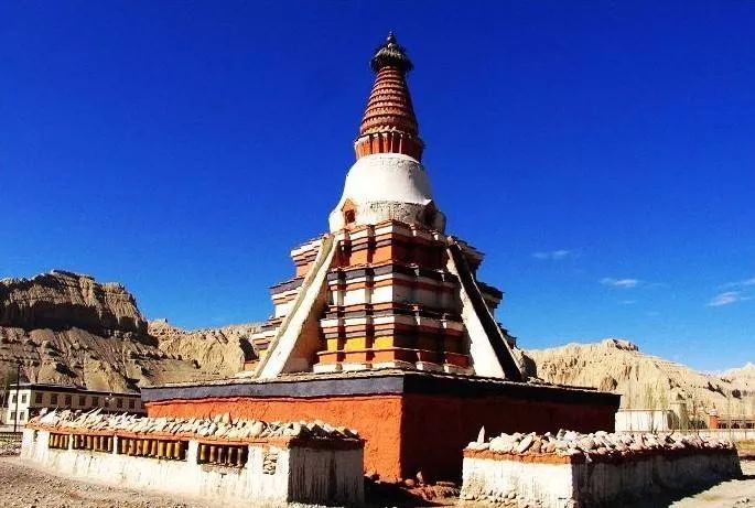
托林寺/མཐོ་ལྡིང་དགོན་པ
This image, video or audio may be copyrighted. It is used for educational purposes only. If you find it, please notify us byand we will remove it immediately.
You do not currently have editing permission, please login !
西藏航空
http://www.net4info.de/photos/cpg/albums/userpics/10001/Xi20Cang20Hang20Kong20.jpg
This image, video or audio may be copyrighted. It is used for educational purposes only. If you find it, please notify us byand we will remove it immediately.
西藏会展中心

This image, video or audio may be copyrighted. It is used for educational purposes only. If you find it, please notify us byand we will remove it immediately.
You do not currently have editing permission, please login !
西藏博物館 西藏博物馆

This image, video or audio may be copyrighted. It is used for educational purposes only. If you find it, please notify us byand we will remove it immediately.
西藏旅游地图
http://www.net4info.de/photos/cpg/albums/userpics/10002/Xi20Cang20Lu20You20Di20Tu20.png
This image, video or audio may be copyrighted. It is used for educational purposes only. If you find it, please notify us byand we will remove it immediately.