
Deutsch-Chinesische Enzyklopädie, 德汉百科
 Nordmazedonien
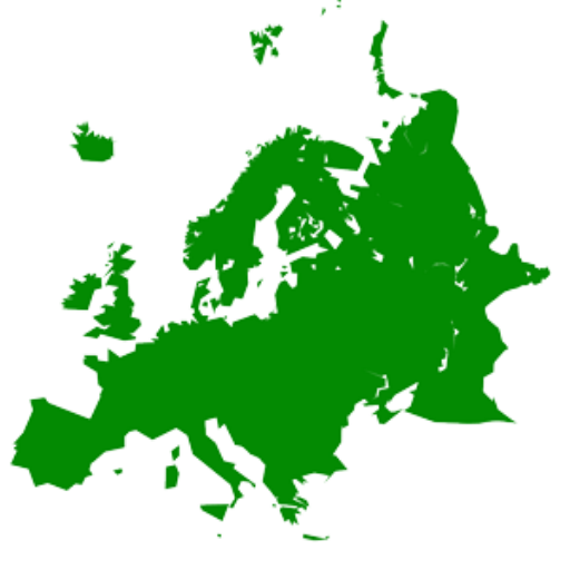 States of Europe
 Mitglieder der NATO

北马其顿共和国(马其顿语:Република Северна Македонија,转写:Republika Severna Makedonija),通称北马其顿(马其顿语:Северна Македонија,转写:Severna Makedonija),是位于东南欧的巴尔干半岛南部的内陆国家,东临保加利亚,北临塞尔维亚,西临阿尔巴尼亚,南临希腊。首都与最大都市是斯科普里。原为南斯拉夫社会主义联邦共和国的成员国之一,1991年南斯拉夫解体后获得独立,当时国号为马其顿共和国(马其顿语:Република Македонија,转写:Republika Makedonija,通称马其顿或前南斯拉夫马其顿共和国),由于在“马其顿”名称的使用上与邻邦希腊长期存在争议,2019年2月12日起国号改为现名[3]。2020年3月27日,北马其顿加入北约,成为该组织第30个会员国。
Nordmazedonien (mazedonisch Северна Македонија Severna Makedonija, albanisch Maqedonia e Veriut; amtlich Republik Nordmazedonien, mazedonisch Република Северна Македонија Republika Severna Makedonija, albanisch Republika e Maqedonisë së Veriut; bis 2019: Republik Mazedonien) ist ein Binnenstaat in Südosteuropa. Er umfasst den nördlichen Teil der historischen Region Makedonien.
Seit dem 27. März 2020 ist Nordmazedonien Mitglied der NATO sowie bereits seit 2005 ein Beitrittskandidat der Europäischen Union (EU). Nordmazedonien hat eine der schwächsten Volkswirtschaften Europas und befindet sich in einem Transformationsprozess, sowohl wirtschaftlich als auch politisch. Das Land hat mit hohen Arbeitslosenzahlen und einer schwachen Infrastruktur sowie fehlenden Investitionen zu kämpfen.
Neben slawischen Mazedoniern, die etwa 64 % der Gesamtbevölkerung stellen, gibt es eine große Minderheit an Albanern (25 %). Auch kleinere Minderheiten von Türken (3,85 %), Roma (2,66 %), Serben (1,78 %), Bosniaken (0,84 %) und Aromunen/Meglenorumänen (0,48 %) sowie anderen Ethnien (1,04 %) sind vorhanden. Durch diese Situation gab und gibt es immer wieder ethnisch motivierte Konflikte, vor allem zwischen Mazedoniern und Albanern. Nach den bürgerkriegsähnlichen Zuständen 2001 und dem danach unterschriebenen Friedensvertrag hat sich die Gesamtlage im Land deutlich verbessert. Eine gesellschaftliche Gleichstellung aller Ethnien ist jedoch immer noch nicht erreicht.
北マケドニア共和国(きたマケドニアきょうわこく、マケドニア語: Република Северна Македонија、アルバニア語: Republika e Maqedonisë së Veriut)、通称北マケドニア(マケドニア語: Северна Македонија、アルバニア語: Maqedonia e Veriut)は、東ヨーロッパのバルカン半島に位置する共和国。前身はユーゴスラビア連邦の構成国の1つで、南はギリシャ、東はブルガリア、西はアルバニア、北はセルビアおよびコソボと、四方を外国に囲まれた内陸国である。
North Macedonia[c] (before 2019, Macedonia), officially the Republic of North Macedonia,[d] is a country in the Balkan Peninsula in Southeast Europe. It gained its independence in 1991 as one of the successor states of Yugoslavia. A landlocked country, North Macedonia has borders with Kosovo[e] to the northwest, Serbia to the northeast, Bulgaria to the east, Greece to the south, and Albania to the west.[8] It constitutes approximately the northern third of the larger geographical region of Macedonia. The capital and largest city, Skopje, is home to roughly a quarter of the country's 2.06 million inhabitants. The majority of the residents are ethnic Macedonians, a South Slavic people. Albanians form a significant minority at around 25%, followed by Turks, Romani, Serbs, Bosniaks, and Aromanians.
The history of the region dates back to antiquity, beginning with the kingdom of Paeonia, presumably a mixed Thraco-Illyrian polity.[9] In the late sixth century BC, the area was incorporated into the Persian Achaemenid Empire, then annexed by the kingdom of Macedonia in the fourth century BC. The Romans conquered the region in the second century BC and made it part of the much larger province of Macedonia. The area remained part of the Byzantine Empire, but was often raided and settled by Slavic tribes beginning in the sixth century of the Christian era. Following centuries of contention between the Bulgarian, Byzantine, and Serbian Empire, it was part of the Ottoman dominion from the mid-14th until the early 20th century, when, following the Balkan Wars of 1912 and 1913, the modern territory of North Macedonia came under Serbian rule.
During the First World War (1915–1918), it was ruled by Bulgaria, but after the end of the war it returned to being under Serbian rule as part of the newly formed Kingdom of Serbs, Croats and Slovenes. Later, during the Second World War (1941–1944), it was ruled by Bulgaria again, and in 1945 it was established as a constituent state of communist Yugoslavia, which it remained until its peaceful secession in 1991. The country became a member of the United Nations in April 1993, but as a result of a dispute with Greece over the name "Macedonia", it was admitted under the provisional description the former Yugoslav Republic of Macedonia[f] (abbreviated as FYR Macedonia and FYROM). In June 2018, Macedonia and Greece resolved the conflict with an agreement that the country should rename itself "Republic of North Macedonia". This renaming came into effect in February 2019.
A unitary parliamentary constitutional republic, North Macedonia is a member of the UN, NATO, Council of Europe, World Bank, OSCE, CEFTA, and the WTO. Since 2005, it has also been a candidate for joining the European Union. North Macedonia is an upper-middle-income country[12] and has undergone considerable economic reform since independence in developing an open economy. North Macedonia is a developing country, ranking 82nd on the Human Development Index, and provides a social security, universal health care system, and free primary and secondary education to its citizens.
La Macédoine du Nordb (en macédonien Северна Македонија, translitterré Severna Makedonija ; en albanais Maqedonia e Veriut), en forme longue la république de Macédoine du Nord (en macédonien Република Северна Македонија, translitterré Republika Severna Makedonija ; en albanais Republika e Maqedonisë së Veriut), est un pays d'Europe du Sud situé dans la péninsule des Balkans.
Connue de 1991 à 2019 sous le nom de « république de Macédoine » ou « ancienne république yougoslave de Macédoine » (ou par le sigle ARYM)b, ou parfois simplement « Macédoine » dans le langage courant, elle est l'un des États successeurs de la Yougoslavie, dont elle a déclaré son indépendance en 1991. Par le nom très ressemblant entre la Macédoine du Nord et la région grecque de la Macédoine, des tensions éclatent, jusqu'à une sortie de crise le 12 février 2019, où l'accord entre la nouvelle République de Macédoine du Nord et la République hellénique (qui a été validé par référendum puis ratification par les deux parlements9) entre en vigueur, et donne son nouveau nom à cet État. Ce changement de nom va ainsi lui permettre de prétendre à l'adhésion aux institutions internationales, comme l'OTAN ou l'Union européenne.
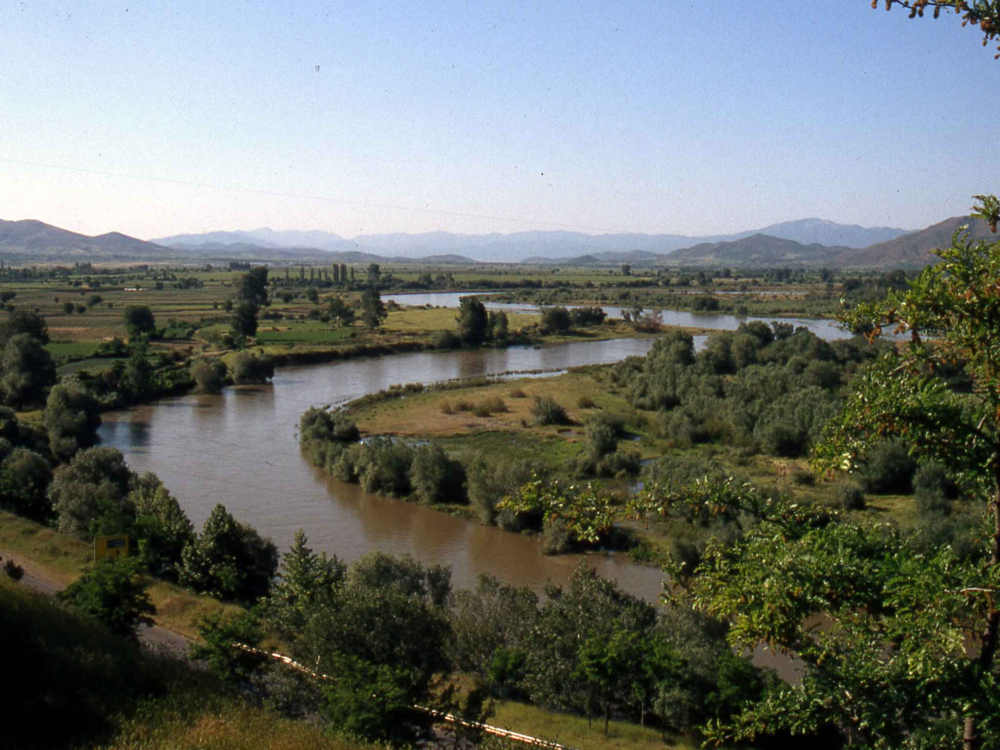
Sans accès à la mer, la Macédoine du Nord partage des frontières avec la Grèce, la Bulgarie, la Serbie, le Kosovoc et l'Albanie. Le pays, qui compte deux millions d'habitants, occupe approximativement la moitié nord de la Macédoine géographique, qui s'étend aussi en Bulgarie et en Grèce. Sa capitale et plus grande ville est Skopje, suivie par Koumanovo, Bitola, Prilep et Tetovo. Le pays est principalement montagneux et compte une cinquantaine de lacs.
Par sa position en Europe, le territoire de la république a connu de nombreuses occupations et migrations, les plus marquantes étant l'âge byzantin, l'arrivée des Slaves au VIe siècle, puis une domination ottomane longue de cinq siècles. Ces présences ont façonné une culture riche en influences, puisqu'en plus de citoyens appartenant au peuple macédonien, le pays compte d'importantes minorités albanaise, turque et rom. La Macédoine du Nord compte une majorité d'habitants chrétiens orthodoxes, mais aussi une forte communauté musulmane.
La Macédoine du Nord possède un régime politique démocratique et parlementaire. Longtemps isolée après son indépendance, elle connaît une transition difficile à l'économie de marché. Elle se classe en effet parmi les États européens avec un indice de développement humain des plus bas. L'adhésion du pays à l'Union européenne a été définie comme la principale priorité stratégique par le gouvernement macédonien en 200611. Les négociations d'adhésion ont formellement été ouvertes par le Conseil européen le 26 mars 202012.
Elle est membre de l'Organisation des Nations Unies, du Conseil de l'Europe et de l'Organisation du Traité de l'Atlantique Nord depuis peu (27 mars 20207).
La Macedonia del Nord, ufficialmente Repubblica della Macedonia del Nord (in macedone: Република Северна Македонија?, traslitterato: Republika Severna Makedonija; in albanese: Republika e Maqedonisë së Veriut), è uno Stato della penisola balcanica nell'Europa sud-orientale.
Fino al 2019 lo Stato si chiamava Repubblica di Macedonia ed è stato coinvolto in un'annosa disputa sul proprio nome con la Grecia; in base all'accordo di Prespa del giugno del 2018, nonostante il mancato raggiungimento del quorum nel referendum consultivo del 30 settembre, il parlamento macedone ha approvato nel gennaio del 2019 una modifica costituzionale per adottare il nome di Macedonia del Nord e poter così successivamente aderire con la nuova denominazione alla NATO e all'Unione europea.[7][8] Il cambio del nome è poi divenuto effettivo il successivo 12 febbraio.[9] Dal 27 marzo 2020 lo Stato fa quindi parte della NATO.
Da alcuni stati, tra cui quelli dell'Unione europea, nonché dall'Unione medesima e da altre entità sovranazionali, era riconosciuta come Ex Repubblica Jugoslava di Macedonia[10] (abbreviato ERJM o ERIM;[11] in inglese Former Yugoslav Republic of Macedonia, FYROM; in macedone Πоранешна Југословенска Република Македонија, Poranešna Jugoslovenska Republika Makedonija) a seguito dell'adesione del Paese all'ONU (1993) con tale "denominazione provvisoria".[12]
Stato senza sbocco al mare, la Macedonia del Nord confina a sud-ovest con l'Albania, a nord-est con la Bulgaria, a nord con la Serbia e il Kosovo e a sud-est con la Grecia. Il territorio governato dalla Macedonia era in precedenza la parte meridionale estrema della Jugoslavia. I confini odierni vennero fissati poco dopo la seconda guerra mondiale, quando la Jugoslavia socialista stabilì nella zona la Repubblica Popolare di Macedonia, riconoscendo i macedoni come una nazione separata all'interno della Jugoslavia. Rinominatasi Repubblica di Macedonia l'8 settembre 1991, si separò pacificamente dalla Jugoslavia senza ulteriori modificazioni territoriali.
Dal 2001 la Macedonia è una democrazia parlamentare (vedi Cristianesimo democratico e Movimenti liberali nell'Islam).
Macedonia del Norte (en macedonio: Северна Македонија, romanización: Severna Makedóniya), oficialmente República de Macedonia del Norte (en macedonio: Република Северна Македонија, romanización: Repúblika Severna Makedóniya), y hasta febrero de 2019 llamado la ex República Yugoslava de Macedonia7 o más adecuadamente Antigua República Yugoslava de Macedonia,8 es un país independiente sin litoral, situado en la península balcánica, en el sureste de Europa. Limita al norte con Serbia y Kosovo,Nota 2 al este con Bulgaria, al sur con Grecia y al oeste con Albania. Su capital es Skopie, con más de 700 000 habitantes.
Este país surgió en 1991 después de que la antigua República Socialista de Macedonia, una de las partes constituyentes de la República Federal Socialista de Yugoslavia, declarara su independencia con el nombre de «República de Macedonia» (Република Македонија, República Makedóniya),Nota 3 y con el nombre corto de «Macedonia», en algunos casos. El uso del término «Macedonia» fue rechazado por Grecia, y surgió una disputa sobre la denominación de este país entre ambos estados. Como postura intermedia, en 1993 se adoptó la referencia provisional «Antigua República Yugoslava de Macedonia»11 (Поранешна Југословенска Република Македонија, Poranešna Jugoslovenska Republika Makedonija, en macedonio) para denominar al Estado macedonio en algunas organizaciones internacionales, como en la Organización de las Naciones Unidas. El conflicto perduró hasta febrero de 2019, después de que ambas partes aceptaran el uso definitivo del nombre de «República de Macedonia del Norte».Nota 4
Се́верная Македо́ния (макед. Северна Македонија, алб. Maqedonia e Veriut), полное официальное название — Респу́блика Се́верная Македо́ния (макед. Република Северна Македонија, алб. Republika e Maqedonisë së Veriut) — государство на юго-востоке Европы, на Балканском полуострове. Население, по данным Государственного статистического управления Республики Северная Македония, составляет 2 073 702 человека, территория — 25 333 км². Занимает 145-е место в мире по численности населения и 145-е по территории.
Столица — Скопье. Единственным государственным языком является македонский. Албанский имеет статус «второго официального языка» (макед. втор официјален јазик), но не употребляется в сфере международных отношений, обороны, центральной полиции и монетарной политики.
Унитарное государство, парламентская республика. 3 января 2020 года пост премьер-министра занял Оливер Спасовский.
Подразделяется на 85 административно-территориальных единиц, 84 из которых являются общинами и город Скопье, как самостоятельную единицу местного самоуправления.
Не имеет выхода к морю. На севере граничит с частично признанной Республикой Косово[5] и Сербией, на западе — с Албанией, на юге — с Грецией, на востоке — с Болгарией.
Отличается значительным этнокультурным разнообразием. Около 67 % населения исповедует православие, мусульмане составляют 30 % от общего числа жителей, а приверженцев других конфессий — 3 %.
Аграрно-индустриальная страна с динамично развивающейся экономикой. Объём ВВП по паритету покупательной способности за 2017 год составил 31,03 миллиарда долларов США (около 14 900 долларов США на душу населения). Денежная единица — македонский денар. Член НАТО с 30 марта 2020[6].
 Architecture
 History
 Civilization

 Afghanistan
Egypt
Albania
Antigua and Barbuda
Argentina
Armenia
Azerbaijan
Bahrain
Bangladesh
Barbados
Beijing Shi-BJ
Belarus
Belgium
Amber Road
Bolivia
Bosnia Herzegovina
Bulgaria
Chile
China
Chongqing Shi-CQ
Columbia
Costa Rica
Cuba
Demokratische Republik Timor-Leste
Dominica
Dominikanische Republik
Ecuador
Eritrea
Fidschi
Fujian Sheng-FJ
Gansu Sheng-GS
Georgia
Grenada
Greece
Guangdong Sheng-GD
Guangxi Zhuangzu Zizhiqu-GX
Guyana
Hainan Sheng-HI
Afghanistan
Egypt
Albania
Antigua and Barbuda
Argentina
Armenia
Azerbaijan
Bahrain
Bangladesh
Barbados
Beijing Shi-BJ
Belarus
Belgium
Amber Road
Bolivia
Bosnia Herzegovina
Bulgaria
Chile
China
Chongqing Shi-CQ
Columbia
Costa Rica
Cuba
Demokratische Republik Timor-Leste
Dominica
Dominikanische Republik
Ecuador
Eritrea
Fidschi
Fujian Sheng-FJ
Gansu Sheng-GS
Georgia
Grenada
Greece
Guangdong Sheng-GD
Guangxi Zhuangzu Zizhiqu-GX
Guyana
Hainan Sheng-HI
 Hand in Hand
Hebei Sheng-HE
Heilongjiang Sheng-HL
Henan Sheng-HA
Honduras
Hongkong Tebiexingzhengqu-HK
Indonesia
Iraq
Iran
Jamaika
Yemen
Jiangsu Sheng-JS
Jiangxi Sheng-JX
Jilin Sheng-JL
Jordan
Cambodia
Kasachstan
Katar
Kenya
Kenya
Kyrgyzstan
Croatia
Kuwait
Laos
Latvia
Liaoning Sheng-LN
Libanon
Lithuania
Luxembourg
Madagaskar
Malaysia
Malediven
Malta
Moldawien
Hand in Hand
Hebei Sheng-HE
Heilongjiang Sheng-HL
Henan Sheng-HA
Honduras
Hongkong Tebiexingzhengqu-HK
Indonesia
Iraq
Iran
Jamaika
Yemen
Jiangsu Sheng-JS
Jiangxi Sheng-JX
Jilin Sheng-JL
Jordan
Cambodia
Kasachstan
Katar
Kenya
Kenya
Kyrgyzstan
Croatia
Kuwait
Laos
Latvia
Liaoning Sheng-LN
Libanon
Lithuania
Luxembourg
Madagaskar
Malaysia
Malediven
Malta
Moldawien
 Mongolei
Montenegro
Myanmar
Nei Mongol Zizhiqu-NM
Nepal
New Zealand
Nicaragua
Ningxia Huizu Zizhiqu-NX
Nordmazedonien
Oman
Austria
Pakistan
Palestine
Papua-Neuguinea
Peru
Poland
Portugal
Qinghai Sheng-QH
Republik El Salvador
Republic of Korea
Republic of the Sudan
Romania
Russia
Switzerland
Silk road
Serbia
Serbia
Shaanxi Sheng-SN
Shanghai Shi-SH
Sichuan Sheng-SC
Singapore
Slovakia
Slovenia
Somalia
Sri Lanka
South Africa
Suriname
Syria
Tajikistan
Taiwan Sheng-TW
Thailand
Tianjin Shi-TJ
Trinidad und Tobago
Turkey
Turkmenistan
Ukraine
Hungary
Uruguay
Uzbekistan
Venezuela
United Arab Emirates
Vietnam
Mongolei
Montenegro
Myanmar
Nei Mongol Zizhiqu-NM
Nepal
New Zealand
Nicaragua
Ningxia Huizu Zizhiqu-NX
Nordmazedonien
Oman
Austria
Pakistan
Palestine
Papua-Neuguinea
Peru
Poland
Portugal
Qinghai Sheng-QH
Republik El Salvador
Republic of Korea
Republic of the Sudan
Romania
Russia
Switzerland
Silk road
Serbia
Serbia
Shaanxi Sheng-SN
Shanghai Shi-SH
Sichuan Sheng-SC
Singapore
Slovakia
Slovenia
Somalia
Sri Lanka
South Africa
Suriname
Syria
Tajikistan
Taiwan Sheng-TW
Thailand
Tianjin Shi-TJ
Trinidad und Tobago
Turkey
Turkmenistan
Ukraine
Hungary
Uruguay
Uzbekistan
Venezuela
United Arab Emirates
Vietnam
 World Heritage
 Economy and trade
Xinjiang Uygur Zizhiqu-XJ
Zhejiang Sheng-ZJ
Zhejiang Sheng-ZJ
Cyprus
Economy and trade
Xinjiang Uygur Zizhiqu-XJ
Zhejiang Sheng-ZJ
Zhejiang Sheng-ZJ
Cyprus

丝绸之路(德语:Seidenstraße;英语:Silk Road),常简称为丝路,此词最早来自于德意志帝国地理学家费迪南·冯·李希霍芬男爵于1877年出版的一套五卷本的地图集。[1]
丝绸之路通常是指欧亚北部的商路,与南方的茶马古道形成对比,西汉时张骞以长安为起点,经关中平原、河西走廊、塔里木盆地,到锡尔河与乌浒河之间的中亚河中地区、大伊朗,并联结地中海各国的陆上通道。这条道路也被称为“陆路丝绸之路”,以区别日后另外两条冠以“丝绸之路”名称的交通路线。因为由这条路西运的货物中以丝绸制品的影响最大,故得此名。其基本走向定于两汉时期,包括南道、中道、北道三条路线。但实际上,丝绸之路并非是一条 “路”,而是一个穿越山川沙漠且没有标识的道路网络,并且丝绸也只是货物中的一种。[1]:5
广义的丝绸之路指从上古开始陆续形成的,遍及欧亚大陆甚至包括北非和东非在内的长途商业贸易和文化交流线路的总称。除了上述的路线之外,还包括约于前5世纪形成的草原丝绸之路、中古初年形成,在宋代发挥巨大作用的海上丝绸之路和与西北丝绸之路同时出现,在宋初取代西北丝绸之路成为路上交流通道的南方丝绸之路。
虽然丝绸之路是沿线各君主制国家共同促进经贸发展的产物,但很多人认为,西汉的张骞在前138—前126年和前119年曾两次出使西域,开辟了中外交流的新纪元,并成功将东西方之间最后的珠帘掀开。司马迁在史记中说:“于是西北国始通于汉矣。然张骞凿空,其后使往者皆称博望侯,以为质与国外,外国由此信之”,称赞其开通西域的作用。从此,这条路线被作为“国道”踩了出来,各国使者、商人、传教士等沿着张骞开通的道路,来往络绎不绝。上至王公贵族,下至乞丐狱犯,都在这条路上留下了自己的足迹。这条东西通路,将中原、西域与大伊朗、累范特、阿拉伯紧密联系在一起。经过几个世纪的不断努力,丝绸之路向西伸展到了地中海。广义上丝路的东段已经到达了朝鲜、日本,西段至法国、荷兰。通过海路还可达意大利、埃及,成为亚洲和欧洲、非洲各国经济文化交流的友谊之路。
丝绸之路经济带和21世纪海上丝绸之路(英语:The Silk Road Economic Belt and the 21st-century Maritime Silk Road[1]),简称一带一路(英语:The Belt and Road Initiative,缩写B&R)[1],是中华人民共和国政府于2013年倡议[2]并主导的跨国经济带[3]。
一带一路范围涵盖历史上丝绸之路和海上丝绸之路行经的中国、中亚、北亚和西亚、印度洋沿岸、地中海沿岸的国家和地区。中国政府指出,“一带一路”倡议坚持共商、共建、共享的原则,努力实现沿线区域基础设施更加完善,更加安全高效,以形成更高水平的陆海空交流网络。同时使投资贸易的便利化水平更有效的提升,建立高品质、高标准的自由贸易区域网。以使沿线各国经济联系更加紧密,政治互信更加的深入,人文交流更加的广泛[4]。
Als Seidenstraße (chinesisch 絲綢之路 / 丝绸之路, Pinyin Sīchóu zhī Lù ‚die Route / Straße der Seide‘; mongolisch ᠲᠣᠷᠭᠠᠨ ᠵᠠᠮ Tôrgan Jam; kurz: 絲路 / 丝路, Sīlù) bezeichnet man ein altes Netz von Karawanenstraßen, dessen Hauptroute den Mittelmeerraum auf dem Landweg über Zentralasien mit Ostasien verband. Die Bezeichnung geht auf den im 19. Jahrhundert lebenden deutschen Geografen Ferdinand von Richthofen zurück, der den Begriff 1877 erstmals verwendet hat.
Auf der antiken Seidenstraße wurde in westliche Richtung hauptsächlich Seide, gen Osten vor allem Wolle, Gold und Silber gehandelt.[1] Nicht nur Kaufleute, Gelehrte und Armeen nutzten ihr Netz, sondern auch Ideen, Religionen und ganze Kulturkreise diffundierten und migrierten auf den Routen von Ost nach West und umgekehrt: hierüber kamen z. B. der Nestorianismus (aus dem spätantiken Römischen Reich) und der Buddhismus (von Indien) nach China.[1]
Die 6.400 Kilometer[1] lange Route begann in Xi’an und folgte dem Verlauf der Chinesischen Mauer in Richtung Nordwesten, passierte die Taklamakan-Wüste, überwand das Pamirgebirge und führte über Afghanistan in die Levante; von hier wurden die Handelsgüter dann über das Mittelmeer verschifft. Nur wenige Kaufleute reisten auf der gesamten Route, die Waren wurden eher gestaffelt über Zwischenhändler transportiert.
Ihre größte Bedeutung erreichte das Handels- und Wegenetz zwischen 115 v. Chr. und dem 13. Jahrhundert n. Chr. Mit dem allmählichen Verlust römischen Territoriums in Asien und dem Aufstieg Arabiens in der Levante wurde die Seidenstraße zunehmend unsicher und kaum noch bereist. Im 13. und 14. Jahrhundert wurde die Strecke unter den Mongolen wiederbelebt, u. a. benutzte sie zu der Zeit der Venezianer Marco Polo um nach Cathay (China) zu reisen. Nach weit verbreiteter Ansicht war die Route einer der Hauptwege, über die Mitte des 14. Jahrhunderts Pestbakterien von Asien nach Europa gelangten und dort den Schwarzen Tod verursachten.[1]
Teile der Seidenstraße sind zwischen Pakistan und dem autonomen Gebiet Xinjiang in China heute noch als asphaltierte Fernstraße vorhanden (-> Karakorum Highway). Die alte Straße inspirierte die Vereinten Nationen zu einem Plan für eine transasiatische Fernstraße. Von der UN-Wirtschafts- und Sozialkommission für Asien und den Pazifik (UNESCAP) wird die Einrichtung einer durchgehenden Eisenbahnverbindung entlang der Route vorangetrieben, der Trans-Asian Railway.[1]
Die "Neue Seidenstraße", das "One Belt, One Road"-Projekt der Volksrepublik China unter ihrem Staatspräsident Xi Jinping umfasst landgestützte (Silk Road Economic Belt) und maritime (Maritime Silk Road) Infrastruktur- und Handelsrouten, Wirtschaftskorridore und Transportlinien von China über Zentralasien und Russland bzw. über Afrika nach Europa, dazu werden verschiedenste Einrichtungen (z. B. Tiefsee- oder Containerterminals) und Verbindungen (wie Bahnlinien oder Gaspipelines) entwickelt bzw. ausgebaut. Bestehende Korridore sind einerseits Landverbindungen über die Türkei oder Russland und andererseits Anknüpfungen zum Hafen von Shanghai, über Hongkong und Singapur nach Indien und Ostafrika, Dubai, den Suez-Kanal, den griechischen Hafen Piräus nach Venedig.[2]
Das Projekt One Belt, One Road (OBOR, chinesisch 一帶一路 / 一带一路, Pinyin Yídài Yílù ‚Ein Band, Eine Straße‘, neuerdings Belt and Road, da „One“ zu negativ besetzt war) bündelt seit 2013 die Interessen und Ziele der Volksrepublik China unter Staatspräsident Xi Jinping zum Auf- und Ausbau interkontinentaler Handels- und Infrastruktur-Netze zwischen der Volksrepublik und zusammen 64 weiteren Ländern Afrikas, Asiens und Europas. Die Initiative bzw. das Gesamtprojekt betrifft u. A. rund 62 % der Weltbevölkerung und ca. 35 % der Weltwirtschaft.[1][2]
Umgangssprachlich wird das Vorhaben auch „Belt and Road Initiative“ (B&R, BRI) bzw. ebenso wie das Projekt Transport Corridor Europe-Caucasus-Asia (TRACECA) auch „Neue Seidenstraße“ (新絲綢之路 / 新丝绸之路, Xīn Sīchóuzhīlù) genannt. Es bezieht sich auf den geografischen Raum des historischen, bereits in der Antike genutzten internationalen Handelskorridors „Seidenstraße“; zusammengefasst handelt es sich um zwei Bereiche, einen nördlich gelegenen zu Land mit sechs Bereichen unter dem Titel Silk Road Economic Belt und einen südlich gelegenen Seeweg namens Maritime Silk Road.
シルクロード(絹の道、英語: Silk Road, ドイツ語: Seidenstraße, 繁体字:絲綢之路, 簡体字:丝绸之路)は、中国と地中海世界の間の歴史的な交易路を指す呼称である。絹が中国側の最も重要な交易品であったことから名付けられた。その一部は2014年に初めて「シルクロード:長安-天山回廊の交易路網」としてユネスコの世界遺産に登録された。
「シルクロード」という名称は、19世紀にドイツの地理学者リヒトホーフェンが、その著書『China(支那)』(1巻、1877年)においてザイデンシュトラーセン(ドイツ語:Seidenstraßen;「絹の道」の複数形)として使用したのが最初であるが、リヒトホーフェンは古来中国で「西域」と呼ばれていた東トルキスタン(現在の中国新疆ウイグル自治区)を東西に横断する交易路、いわゆる「オアシスの道(オアシスロード)」を経由するルートを指してシルクロードと呼んだのである。リヒトホーフェンの弟子で、1900年に楼蘭の遺跡を発見したスウェーデンの地理学者ヘディンが、自らの中央アジア旅行記の書名の一つとして用い、これが1938年に『The Silk Road』の題名で英訳されて広く知られるようになった。
シルクロードの中国側起点は長安(陝西省西安市)、欧州側起点はシリアのアンティオキアとする説があるが、中国側は洛陽、欧州側はローマと見る説などもある。日本がシルクロードの東端だったとするような考え方もあり、特定の国家や組織が経営していたわけではないのであるから、そもそもどこが起点などと明確に定められる性質のものではない。
現在の日本でこの言葉が使われるときは、特にローマ帝国と秦・漢帝国、あるいは大唐帝国の時代の東西交易が念頭に置かれることが多いが、広くは近代(大航海時代)以前のユーラシア世界の全域にわたって行われた国際交易を指し、南北の交易路や海上の交易路をも含める。つまり、北方の「草原の道(ステップロード)」から南方の「海の道(シーロード)」までを含めて「シルクロード」と呼ばれるようになっているわけである。
シルクロード経済ベルトと21世紀海洋シルクロード(シルクロードけいざいベルトと21せいきかいようシルクロード、拼音: Sīchóu zhī lù jīngjìdài hé èrshíyī shìjì hǎishàng sīchóu zhī lù、英語: The Silk Road Economic Belt and the 21st-century Maritime Silk Road)とは、2014年11月10日に中華人民共和国北京市で開催されたアジア太平洋経済協力首脳会議で、習近平総書記が提唱した経済圏構想である。
略称は一帯一路(いったいいちろ、拼音: Yídài yílù、英語: The Belt and Road Initiative, BRI; One Belt, One Road Initiative, OBOR)。
The Silk Road was an ancient network of trade routes that connected the East and West. It was central to cultural interaction between the regions for many centuries.[1][2][3] The Silk Road refers to both the terrestrial and the maritime routes connecting East Asia and Southeast Asia with East Africa, West Asia and Southern Europe.
The Silk Road derives its name from the lucrative trade in silk carried out along its length, beginning in the Han dynasty (207 BCE–220 CE). The Han dynasty expanded the Central Asian section of the trade routes around 114 BCE through the missions and explorations of the Chinese imperial envoy Zhang Qian.[4] The Chinese took great interest in the safety of their trade products and extended the Great Wall of China to ensure the protection of the trade route.[5]
Trade on the Road played a significant role in the development of the civilizations of China, Korea,[6] Japan,[2] India, Iran, Afghanistan, Europe, the Horn of Africa and Arabia, opening long-distance political and economic relations between the civilizations.[7] Though silk was the major trade item exported from China, many other goods were traded, as well as religions, syncretic philosophies, sciences, and technologies. Diseases, most notably plague, also spread along the Silk Road.[8] In addition to economic trade, the Silk Road was a route for cultural trade among the civilizations along its network.[9]
Traders in ancient history included the Bactrians, Sogdians, Syrians, Jews, Arabs, Iranians, Turkmens, Chinese, Malays, Indians, Somalis, Greeks, Romans, Georgians, Armenians, and Azerbaijanis.[10]
In June 2014, UNESCO designated the Chang'an-Tianshan corridor of the Silk Road as a World Heritage Site. The Indian portion is on the tentative site list.
The Belt and Road Initiative (BRI) or the Silk Road Economic Belt and the 21st-century Maritime Silk Road is a development strategy adopted by the Chinese government. The 'belt' refers to the overland interconnecting infrastructure corridors; the Silk Road Economic Belt (SREB) component. The 'road' refers to the sea route corridors; the 21st Century Maritime Silk Road (MSR) component.[2] The initiative focuses on connectivity and cooperation between Eurasian countries, primarily the People's Republic of China (PRC).
Until 2016 the initiative was known in English as the One Belt and One Road Initiative (OBOR) but the Chinese came to consider the emphasis on the word "one" as misleading.[3]
The Chinese government calls the initiative "a bid to enhance regional connectivity and embrace a brighter future".[4] Independent observers, however, see it as a push for Chinese dominance in global affairs with a China-centered trading network.[5][6]
La route de la soie est un réseau ancien de routes commerciales entre l'Asie et l'Europe, reliant la ville de Chang'an (actuelle Xi'an) en Chine à la ville d'Antioche, en Syrie médiévale (aujourd'hui en Turquie). Elle tire son nom de la plus précieuse marchandise qui y transitait : la soie.
La route de la soie était un faisceau de pistes par lesquelles transitaient de nombreuses marchandises, et qui monopolisa les échanges Est-Ouest pendant des siècles. Les plus anciennes traces connues de la route de la soie, comme voie de communication avec les populations de l'Ouest, remontent à « 2000 avant notre ère au moins ». Les Chinois en fixent l'ouverture au voyage de Zhang Qian en 138-1261. Mais la route de la soie s'est développée surtout sous la dynastie Han (221 av. J.-C. - 220 ap. J.-C.), en particulier Han Wudi.
Puis sous la dynastie Tang (618-907). À partir du XVe siècle, la route de la soie est progressivement abandonnée, l'instabilité des guerres turco-byzantines, puis la chute de Constantinople poussent en effet les Occidentaux à chercher une nouvelle route maritime vers les Indes. L'abandon de la route de la soie correspond ainsi au début de la période des « Grandes découvertes » durant laquelle les techniques de transport maritime deviennent de plus en plus performantes. Du côté chinois, les empereurs Ming Yongle, puis Ming Xuanzong chargent, à la même époque, l'amiral Zheng He d'expéditions maritimes similaires.
La nouvelle route de la soie ou la Ceinture et la Route2 (stratégie aussi appelée OBOR en anglais pour One Belt, One Road3) est à la fois un ensemble de liaisons maritimes et de voies ferroviaires entre la Chine et l'Europe passant par le Kazakhstan, la Russie, la Biélorussie, la Pologne, l'Allemagne, la France et le Royaume-Uni.
Le nouveau nom est Initiative route et ceinture (Belt and Road Initiative, B&R selon l’acronyme anglais) afin de marquer le fait que ce projet ne se limite pas à une seule route4.
Outre l'amélioration de la connectivité ferroviaire, il s'agit aussi d'une stratégie de développement pour promouvoir la coopération entre les pays sur une vaste bande s'étendant à travers l'Eurasie et pour renforcer la position de la Chine sur le plan mondial, par exemple en préservant la connexion de la Chine avec le reste du monde en cas de tensions militaires sur ses zones côtières5.
La Nouvelle route de la soie a été dévoilée à l'automne 2013 par le gouvernement chinois en tant que pendant terrestre du collier de perles6 ; elle est l'une des priorités de la diplomatie chinoise, sous la présidence de Xi Jinping7.
Selon CNN, ce projet englobera 68 pays représentant 4,4 milliards d’habitants et 62 % du PIB mondial8.
Per via della seta (in cinese: 絲綢之路T, 丝绸之路S, sī chóu zhī lùP; persiano: راه ابریشم, Râh-e Abrisham) s'intende il reticolo, che si sviluppava per circa 8.000 km, costituito da itinerari terrestri, marittimi e fluviali lungo i quali nell'antichità si erano snodati i commerci tra l'impero cinese e quello romano.
Le vie carovaniere attraversavano l'Asia centrale e il Medio Oriente, collegando Chang'an (oggi Xi'an), in Cina, all'Asia Minore e al Mediterraneo attraverso il Medio Oriente e il Vicino Oriente. Le diramazioni si estendevano poi a est alla Corea e al Giappone e, a Sud, all'India. Il nome apparve per la prima volta nel 1877, quando il geografo tedesco Ferdinand von Richthofen (1833-1905) pubblicò l'opera Tagebucher aus China. Nell'Introduzione von Richthofen nomina la Seidenstraße, la «via della seta».
La destinazione finale della seta che su di essa viaggiava (non certo da sola ma insieme a tante altre merci preziose) era Roma, dove per altro non si sapeva con precisione quale ne fosse l'origine (se animale o vegetale) e da dove provenisse. Altre merci altrettanto preziose viaggiavano in senso inverso, e insieme alle merci viaggiavano grandi idee e religioni (concetti fondamentali di matematica, geometria, astronomia) in entrambi i sensi, manicheismo, e nestorianesimo verso oriente. Sulla via della seta compì un complesso giro quasi in tondo anche il buddhismo, dall'India all'Asia Centrale alla Cina e infine al Tibet (il tutto per trovare itinerari che permettessero di evitare le quasi invalicabili montagne dell'Himalaya).
Questi scambi commerciali e culturali furono determinanti per lo sviluppo e il fiorire delle antiche civiltà dell'Egitto, della Cina, dell'India e di Roma, ma furono di grande importanza anche nel gettare le basi del mondo medievale e moderno.
La Nuova via della seta è un'iniziativa strategica della Cina per il miglioramento dei collegamenti e della cooperazione tra paesi nell'Eurasia. Comprende le direttrici terrestri della "zona economica della via della seta" e la "via della seta marittima del XXI secolo" (in cinese: 丝绸之路经济带和21世纪海上丝绸之路S, Sīchóu zhī lù jīngjìdài hé èrshíyī shìjì hǎishàng sīchóu zhī lùP), ed è conosciuta anche come "iniziativa della zona e della via" (一带一路S, tradotta comunemente in inglese con Belt and Road Initiative, BRI) o "una cintura, una via" e col corrispondente iniziale acronimo inglese OBOR (One belt, one road), poi modificato in BRI per sottolineare l'estensione del progetto non esclusivo solo della Cina[1], nonostante la prospettiva sinocentrica, com'è stato illustrato in un recente studio italiano[2].
Partendo dallo sviluppo delle infrastrutture di trasporto e logistica, la strategia mira a promuovere il ruolo della Cina nelle relazioni globali, favorendo i flussi di investimenti internazionali e gli sbocchi commerciali per le produzioni cinesi. L'iniziativa di un piano organico per i collegamenti terrestri (la cintura) è stata annunciata pubblicamente dal presidente cinese Xi Jinping a settembre del 2013, e la via marittima ad ottobre dello stesso anno, contestualmente alla proposta di costituire la Banca asiatica d'investimento per le infrastrutture (AIIB), dotata di un capitale di 100 miliardi di dollari USA, di cui la Cina stessa sarebbe il principale socio, con un impegno pari a 29,8 miliardi e gli altri paesi asiatici (tra cui l'India e la Russia) e dell'Oceania avrebbero altri 45 miliardi (l'Italia si è impegnata a sottoscrivere una quota di 2,5 miliardi).
La Ruta de la Seda fue una red de rutas comerciales organizadas a partir del negocio de la seda china desde el siglo I a. C., que se extendía por todo el continente asiático, conectando a China con Mongolia, el subcontinente indio, Persia, Arabia, Siria, Turquía, Europa y África. Sus diversas rutas comenzaban en la ciudad de Chang'an (actualmente Xi'an) en China, pasando entre otras por Karakórum (Mongolia), el Paso de Khunjerab (China/Pakistán), Susa (Persia), el Valle de Fergana (Tayikistán), Samarcanda (Uzbekistán), Taxila (Pakistán), Antioquía en Siria, Alejandría (Egipto), Kazán (Rusia) y Constantinopla (actualmente Estambul, Turquía) a las puertas de Europa, llegando hasta los reinos hispánicos en el siglo XV, en los confines de Europa y a Somalia y Etiopía en el África oriental.
El término "Ruta de la Seda" fue creado por el geógrafo alemán Ferdinand Freiherr von Richthofen, quien lo introdujo en su obra Viejas y nuevas aproximaciones a la Ruta de la Seda, en 1877. Debe su nombre a la mercancía más prestigiosa que circulaba por ella, la seda, cuya elaboración era un secreto que solo los chinos conocían. Los romanos (especialmente las mujeres de la aristocracia) se convirtieron en grandes aficionados de este tejido, tras conocerlo antes del comienzo de nuestra era a través de los partos, quienes se dedicaban a su comercio. Muchos productos transitaban estas rutas: piedras y metales preciosos (diamantes de Golconda, rubíes de Birmania, jade de China, perlas del golfo Pérsico), telas de lana o de lino, ámbar, marfil, laca, especias, porcelana, vidrio, materiales manufacturados, coral, etc.
En junio de 2014, la Unesco eligió un tramo de la Ruta de la Seda como Patrimonio de la Humanidad con la denominación Rutas de la Seda: red viaria de la ruta del corredor Chang’an-Tian-shan. Se trata de un tramo de 5000 kilómetros de la gran red viaria de las Rutas de la Seda que va desde la zona central de China hasta la región de Zhetysu, situada en el Asia Central, incluyendo 33 nuevos sitios en China, Kazajistán y Kirguistán.1
La Iniciativa del Cinturón y Ruta de la Seda o Belt and Road Initiative, abreviada BRIZNA (también One Belt, One Road, abreviado OBOR y también la Nueva Ruta de la Seda) y NRS (Nueva Ruta de la Seda) por las siglas en español, es el nombre con que se conoce el proyecto político-económico del Secretario General del Partido Comunista de China, Xi Jinping, que propuso en septiembre de 2013 en sus respectivos viajes a Rusia, Kazajistán y Bielorrusia. Bajo el pretexto de que "hace más de dos milenios, las personas diligentes y valientes de Eurasia exploraron y abrieron nuevas vías de intercambio comercial y cultural que unían las principales civilizaciones de Asia, Europa y África, colectivamente llamadas ruta de la seda por generaciones posteriores", el proyecto quiere conectar Europa, Asia del Sur-Oriental, Asia Central y el Oriente Medio, mediante el modelo económico, e implícitamente político, chino.12
El proyecto parte de la reconstrucción de la antigua ruta de la seda y la creación de una ruta marítima paralela, de aquí el nombre de "Cinturón y Ruta". El proyecto afecta a 60 países, el 75% de las reservas energéticas conocidas al mundo, el 70% de la población mundial y generaría el 55% del PIB mundial. El gobierno comunista chino tiene previsto invertir unos 1,4 billones de dólares. Se trataría de un cinturón económico, pero, que algunos comentaristas occidentales ya denominamos "Plan Marshall del siglo XXI al estilo chino". Esta afirmación se sostiene por el hecho que el propio Secretario General Xi Jinping asegura que el proyecto tiene cinco pilares: comunicación política, circulación monetaria, entente entre pueblos, conectividad vital y fluidez. Todo ello se ha visto reflejado de acá el inicio de su puesta en marcha a través de las inversiones importantes con planes de ayuda para empresas chinas interesadas en el mercado exterior. China por el contrario se defiende y argumenta que no se trata de ningún plan Marshall visto que las condiciones políticas impuestas entonces con el Plan Marshall no existen en este proyecto. Pero, artículos de prensa van más allá de las simples afirmaciones de Plan Marshall a la china y hablan directamente de "nuevo orden mundial chino", atrás quedaría la orden mundial norteamericano.3
Nicola Casarini, director de Investigación para Asia del Instituto Affari Internacionali de Roma, sostiene que se trata de una iniciativa ambiciosa que pretende dar cabida en exceso de capacidad interna y a la voluntad de reestructuración de diferentes sectores estratégicos del país, como la industria pesando. La ruta, sin embargo, ha reactivado, a pesar de pretender ser un medio de pacificación de Oriente Medio, las antiguas tensiones del siglo XIX. A la India y Japón, se añade ahora Rusia y los EE.UU. El presidente proyecta la Belt and Road Initiative por unos treinta años. Así el proyecto tendría que estar terminado para el 2049, año donde el país rememoraría los 100 años de fundación de la República Popular.
Вели́кий шёлковый путь — караванная дорога, связывавшая Восточную Азию со Средиземноморьем в древности и в Средние века. В первую очередь использовался для вывоза шёлка из Китая, с чем и связано его название. Путь был проложен во II веке до н. э., вёл из Сианя через Ланьчжоу в Дуньхуан, где раздваивался: северная дорога проходила через Турфан, далее пересекала Памир и шла в Фергану и казахские степи, южная — мимо озера Лоб-Нор по южной окраине пустыни Такла-Макан через Яркенд и Памир (в южной части) вела в Бактрию, а оттуда — в Парфию, Индию и на Ближний Восток вплоть до Средиземного моря. Термин введён немецким географом Фердинандом фон Рихтгофеном в 1877 году.
«Оди́н по́яс и один путь» (кит. 一带一路) — выдвинутое в 2010-х годах Китайской Народной Республикой (КНР) предложение объединённых проектов «Экономического пояса Шёлкового пути» и «Морского Шёлкового пути XXI века».
Предложение было впервые выдвинуто председателем КНР Си Цзиньпином во время визитов в Казахстан и в Индонезию осенью 2013 года[1]. В таких политических документах, как «План социально-экономического развития на 2015 год» и «Доклад о работе правительства», строительство «Одного пояса и одного пути» было включено в список важных задач, поставленных перед новым правительством Китая. Министр иностранных дел Китая Ван И подчеркнул, что осуществление этой инициативы станет «фокусом» внешнеполитической деятельности КНР в 2015 году. Подтверждено, что этот огромный проект будет включён и в план «13-й пятилетки», который будет принят в 2016 году[2]. Суть данной китайской инициативы заключается в поиске, формировании и продвижении новой модели международного сотрудничества и развития с помощью укрепления действующих региональных двусторонних и многосторонних механизмов и структур взаимодействий с участием Китая. На основе продолжения и развития духа древнего Шёлкового пути «Один пояс и один путь» призывает к выработке новых механизмов регионального экономического партнерства, стимулированию экономического процветания вовлечённых стран, укреплению культурных обменов и связей во всех областях между разными цивилизациями, а также содействию мира и устойчивого развития[3]. По официальным данным Китая, «Один пояс и один путь» охватывает большую часть Евразии, соединяя развивающиеся страны, в том числе «новые экономики», и развитые страны. На территории мегапроекта сосредоточены богатые запасы ресурсов, проживает 63 % населения планеты, а предположительный экономический масштаб — 21 трлн долларов США[4].
 International cities


斯科普里(马其顿语:Скопје,罗马化:Skopje)是马其顿共和国的首都,也是马其顿最大的都市,马其顿全国总人口的三分之一居住在斯科普里。斯科普里也是马其顿的政治、文化、经济、学术的中心都市。斯科普里在古罗马时期的名称是斯库皮(Scupi)。斯科普里附近地区自约公元前4000年以来就有人居住。在今日斯科普里市中心的斯科普里城堡附近发现了新石器时代的集落遗迹。1世纪前夕,集落被罗马人攻克,成为罗马军队的野营地[2][3]。
罗马帝国在395年分为东罗马帝国和西罗马帝国,斯库皮由首都位于君士坦丁堡的东罗马帝国统治。在中世纪的早期,拜占庭和保加利亚第一帝国争夺巴尔干地区的霸权。972年至992年期间,斯科普里是保加利亚第一帝国的首都。1282年开始,斯科普里由塞尔维亚统治。1346年,塞尔维亚帝国将斯科普里设为首都。1392年,斯科普里被奥斯曼帝国征服,奥斯曼人称斯科普里为于斯屈普(Üsküp)。斯科普里在此之后被奥斯曼统治超过500年,是于斯屈普帕夏桑扎克的首府。之后又是科索沃州(Vilayet of Kosovo)的首府。在这一期间,市内建造了许多著名的东方样式的建筑物。
在1912年巴尔干战争期间,斯科普里被塞尔维亚王国征服,第一次世界大战之后,斯科普里成为新建国家塞尔维亚人、克罗地亚人和斯洛文尼亚人王国(后成为南斯拉夫王国)的一部分。第二次世界大战时期,斯科普里被轴心国国家保加利亚王国军队占领。1944年,成为南斯拉夫社会主义联邦共和国的加盟国马其顿社会主义共和国的首都。斯科普里在第二次世界大战之后得到了急速的开发。但因1963年发生了地震,其发展一时停滞。1991年,斯科普里成为自南斯拉夫独立的马其顿共和国的首都。
Skopje (mazedonisch Скопје, albanisch Shkupi bzw. Shkup, türkisch Üsküp) ist die Hauptstadt Mazedoniens und mit über 540.000 Einwohnern zugleich die größte Stadt des Landes. Etwa ein Viertel der Bevölkerung Mazedoniens lebt in der Großstadt. Skopje weist eine mehr als zwei Jahrtausende zurückreichende Besiedlungsgeschichte auf und gehört somit zu den ältesten noch bestehenden Städten des Landes.
Die Stadt am Vardar ist sowohl Sitz des Parlamentes als auch der Regierung. Sie ist ebenso das kulturelle und wirtschaftliche Zentrum des Landes, orthodoxer Bischofssitz und Sitz eines Großmuftis.
スコピエ(マケドニア語: Скопје/Skopje [ˈskɔpjɛ] (![]() 音声ファイル))はマケドニア共和国の首都。
音声ファイル))はマケドニア共和国の首都。
マケドニア共和国の全人口の3分の1が居住する最大の都市であり、同国の政治、文化、経済、学術の中心都市である。古代ローマ期にはスクウピ (en) の名で知られていた。スコピエ周辺は紀元前4000年頃以来人が居住し、新石器時代の集落跡が現代のスコピエ中心部を見下ろすケール城塞(スコピエ城塞)周辺で発見されている。1世紀直前、集落はローマ人によって押さえられ軍の野営地となった。[1][2]
ローマ帝国が395年に東西に分かれるとスクウピはコンスタンティノープルのビザンティンの支配下に入った。中世初期の多くの期間ビザンティンと第一次ブルガリア帝国の間でその覇権が争われ、972年から992年にかけてスコピエには第一次ブルガリア帝国の首都が置かれた。1282年からは町はセルビアの支配下に入り、1346年にセルビア帝国の首都が置かれている。1392年、スコピエの町はオスマン帝国に征服されオスマンの人々は町をユスキュプ(Üsküp)と呼んでいた。以来、約500年以上にわたりオスマンの支配下にありユスキュプ・パシャサンジャクの首都で後にコソボ州 (en) の首都であった。この期間に現在でも市内に残る著名なオリエンタル様式の建築物の多くが造られている。
1912年に町はバルカン戦争の期間セルビア王国によって征服され、第一次世界大戦後、新たに形成された後のユーゴスラビア王国となるスロベニア人・クロアチア人・セルビア人国の一部となる。第二次世界大戦時には町は枢軸国の一部であったブルガリア王国の軍によって占領された。1944年にはユーゴスラビア社会主義連邦共和国の構成国であるマケドニア社会主義共和国の首都となる。スコピエは第二次世界大戦後に急速に開発されるが、1963年に発生した1963年スコピエ地震によりその発展が一時滞る。1991年にはユーゴスラビアから独立しマケドニア共和国の首都となっている。
スコピエはヴァルダル川の上流部にあり、ベオグラードとアテネのバルカン半島の南北を結ぶ回廊に位置しほぼ中間にあたる。金属加工や化学、木材、織物、皮革、印刷産業などの中心でスコピエの産業発展は、貿易、物流、金融部門だけでなく、文化やスポーツの分野においても重点を置かれた開発が伴っている。最新の2002年の公式な国勢調査によればスコピエの人口は506,926人で、2つの非公式な直近の調査によれば668,518人[3] または 491,000人である。Skopje (/ˈskɒpji, -jeɪ/, US also /ˈskoʊp-/;[2] Macedonian: Скопје [ˈskɔpjɛ] (![]() listen)) is the capital and largest city of the Republic of Macedonia. It is the country's political, cultural, economic, and academic center. It was known in the Roman period under the name Scupi.
listen)) is the capital and largest city of the Republic of Macedonia. It is the country's political, cultural, economic, and academic center. It was known in the Roman period under the name Scupi.
The territory of Skopje has been inhabited since at least 4000 BC; remains of Neolithic settlements have been found within the old Kale Fortress that overlooks the modern city centre. Scupi became the capital of Dardania in the second century BC. On the eve of the 1st century AD, the settlement was seized by the Romans and became a military camp.[3][4] When the Roman Empire was divided into eastern and western halves in 395 AD, Scupi came under Byzantine rule from Constantinople. During much of the early medieval period, the town was contested between the Byzantines and the Bulgarian Empire, whose capital it was between 972 and 992.
From 1282, the town was part of the Serbian Empire and acted as its capital city from 1346 to 1371. In 1392, the city was conquered by the Ottoman Turks who called the town Üsküp. The town stayed under Turkish control for over 500 years, serving as the capital of pashasanjak of Üsküb and later the Vilayet of Kosovo. At that time the city was famous for its oriental architecture[citation needed]. In 1912, it was annexed by the Kingdom of Serbia during the Balkan Wars[5] and after the First World War the city became part of the newly formed Kingdom of Serbs, Croats and Slovenes (Kingdom of Yugoslavia) becoming the capital of the Vardarska banovina. In the Second World War the city was conquered by the Bulgarian Army, which was part of the Axis powers. In 1944, it became the capital city of Democratic Macedonia (later Socialist Republic of Macedonia), which was a federal state, part of Democratic Federal Yugoslavia (later Socialist Federal Republic of Yugoslavia). The city developed rapidly after World War II, but this trend was interrupted in 1963 when it was hit by a disastrous earthquake. In 1991, it became the capital city of an independent Macedonia.
Skopje is located on the upper course of the Vardar River, and is located on a major north-south Balkan route between Belgrade and Athens. It is a center for metal-processing, chemical, timber, textile, leather, and printing industries. Industrial development of the city has been accompanied by development of the trade, logistics, and banking sectors, as well as an emphasis on the fields of transportation, culture and sport. According to the last official count from 2002, Skopje has a population of 506,926 inhabitants; according to official estimates, the city has a population of 544,086 inhabitants, as of June 30, 2015.[6]
Skopje (en macédonien Скопје, prononcé [ˈskɔ.pjɛ] (skopiè) Écouter, Scopie en français, en turc Üsküp) est la capitale et la plus grande ville de la république de Macédoine. Elle compte aujourd'hui un peu plus de 500 000 habitants, soit le tiers de la population totale du pays, dont une forte minorité d'Albanais et des communautés turque et rom. Seule métropole macédonienne, elle concentre la majeure partie des fonctions administratives, économiques et culturelles du pays. Elle est située sur un important carrefour routier des Balkans, entre l'Égée et le Danube, et l'Adriatique et la mer Noire, et vit principalement de l'industrie métallurgique, agroalimentaire et textile.
Après avoir été le lieu de diverses occupations préhistoriques, Skopje naît véritablement au Ier siècle avec la fondation d'une colonie romaine appelée « Scupi », qui est rattachée à l'Empire romain d'Orient en 395. La ville antique est détruite par un séisme en 518. Reconstruite quelques kilomètres plus loin et fortifiée, elle connaît de nombreuses invasions au cours des Xe et XIe siècles, entrant au Xe siècle dans le Premier Empire bulgare sous Siméon Ier de Bulgarie, pour revenir dans l'Empire byzantin en 1018 après la défaite du dernier tsar bulgare Samuel par le Basileus Basile II et la disparition du Premier Empire bulgare. La domination byzantine s'achève avec la conquête serbe en 1282, et Skopje devient brièvement la capitale de l'Empire serbe en 1346. L’État s'affaiblit toutefois rapidement et la ville est conquise par les Ottomans en 1392.
La ville devient alors majoritairement musulmane et sa fonction commerciale est favorisée par sa situation entre l'Europe centrale et la mer Égée. Au XVIIe siècle, Skopje est l'une des plus grandes villes des Balkans. Mais elle est incendiée en 1689 au cours de la Deuxième Guerre austro-turque et elle périclite par la suite jusqu'au milieu du XIXe siècle. L'ouverture d'une voie ferrée permet une certaine croissance démographique, et Skopje devient chef-lieu du vilayet du Kosovo en 1877.
Elle redevient serbe en 1912, puis est intégrée à la Yougoslavie en 1918. Chef-lieu de la banovine du Vardar, l'une des dix régions du royaume de Yougoslavie, elle devient capitale de la République socialiste de Macédoine après la Seconde Guerre mondiale, puis, naturellement, capitale de la Macédoine ex-Yougoslave lorsque celle-ci devient indépendante en 1991. Tout au long du XXe siècle, la croissance démographique est soutenue et la ville s'industrialise. Cet essor est brièvement interrompu par le tremblement de terre de 1963. La ville est presque entièrement détruite, mais la reconstruction est rapide et s'accompagne d'une forte croissance des investissements.
Les années qui suivent l'indépendance sont difficiles sur le plan économique. Skopje demeure une ville pauvre par comparaison aux villes européennes, bien que les Skopiotes aient un meilleur niveau de vie que le reste des Macédoniens. La ville se caractérise par une architecture variée, comprenant plusieurs témoignages de la présence ottomane ainsi qu'un important ensemble de style moderniste édifié après le séisme de 1963. Le centre-ville est depuis la fin des années 2000 le siège d'une vaste opération d'urbanisme, destinée à lui donner un visage plus monumental et affirmer son statut de capitale nationale.
Skopje (in macedone Скопје, in albanese Shkup) è la capitale e la città più popolosa della Repubblica di Macedonia, con 506.926 abitanti[1].
La Città di Skopje costituisce una speciale area amministrativa nell'ordinamento dello Stato, la Grande Skopje, costituita da dieci comuni.[2] Con più di un quarto della popolazione del Paese, è il centro politico, culturale, economico ed accademico della nazione. Conosciuta al tempo dei romani sotto il nome di Scupi, la città si è sviluppata rapidamente dopo la seconda guerra mondiale, ma questa crescita venne interrotta nel 1963, quando fu colpita da un disastroso terremoto.
Skopje si trova lungo il corso superiore del fiume Vardar e su una delle strade principali dei Balcani tra l'Europa centrale ed Atene. È un centro principale per le industrie metalmeccaniche, chimiche, tessili, di stampa e concerie, ma ha sofferto molti fallimenti dal 1991. Lo sviluppo industriale della città è stato accompagnato dallo sviluppo del commercio e del settore bancario, così come nel campo della cultura e dello sport. Skopje è anche un mercato di prodotti agricoli e zootecnici. L'università risale al 1949, quindi la città è anche un importante centro culturale nell'ambito della Repubblica. Ospita uno dei due aeroporti dello stato.
Skopie1 (en macedonio: Скопје ![]() [ˈskɔpjɛ] (?·i)) es la capital y la mayor ciudad de la República de Macedonia; sus 668 518 habitantes (según el censo de 2006) suponen la cuarta parte de la población del país.2 La ciudad se encuentra en el curso superior del río Vardar, en una de las principales rutas balcánicas entre Belgrado y Atenas. La ciudad se desarrolló rápidamente tras la Segunda Guerra Mundial, pero esta evolución fue interrumpida en 1963 cuando fue sacudida por un fuerte terremoto. Hoy en día es el centro político, económico, cultural y académico, además de ser un importante centro de industrias metalúrgicas, químicas, madereras, textiles, del cuero y de imprenta. El desarrollo industrial ha ido acompañado por un intenso desarrollo interno y externo del comercio y de la banca, así como de actividades culturales y deportivas.
[ˈskɔpjɛ] (?·i)) es la capital y la mayor ciudad de la República de Macedonia; sus 668 518 habitantes (según el censo de 2006) suponen la cuarta parte de la población del país.2 La ciudad se encuentra en el curso superior del río Vardar, en una de las principales rutas balcánicas entre Belgrado y Atenas. La ciudad se desarrolló rápidamente tras la Segunda Guerra Mundial, pero esta evolución fue interrumpida en 1963 cuando fue sacudida por un fuerte terremoto. Hoy en día es el centro político, económico, cultural y académico, además de ser un importante centro de industrias metalúrgicas, químicas, madereras, textiles, del cuero y de imprenta. El desarrollo industrial ha ido acompañado por un intenso desarrollo interno y externo del comercio y de la banca, así como de actividades culturales y deportivas.
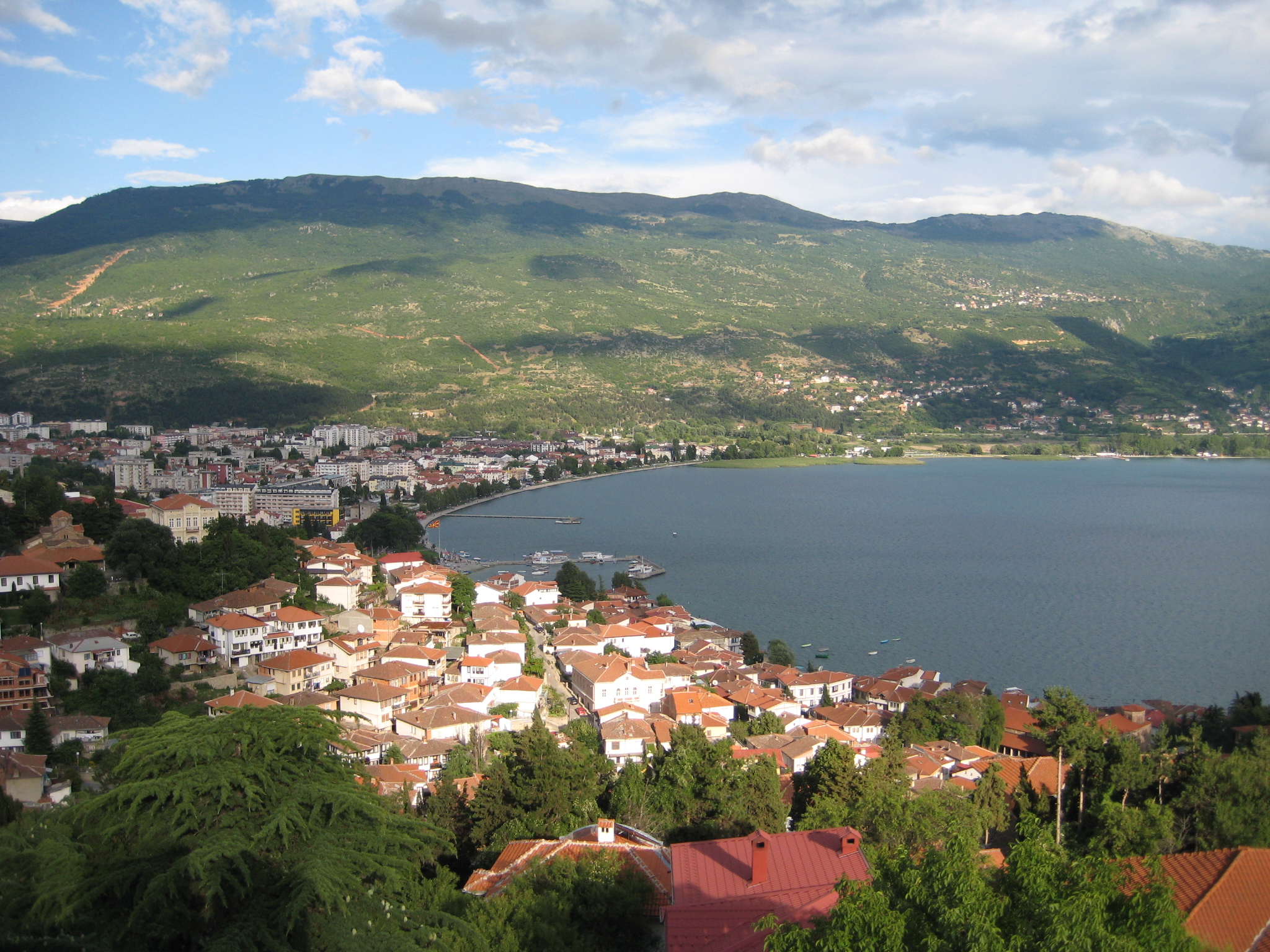
位于奥赫里德湖岸(从1979年被评为世界自然遗产)。奥赫里德镇是欧洲最古老的人类聚集地之一,建于7-19世纪,它拥有大多数古斯拉夫人的修道院和 八百多幅拜占廷风格的画像。这些画像出自于11-14世纪末,它们被认为是世界上除了莫斯科托里托拉可夫(Tretrakov)画库之外最重要的收集。
奥赫里德自然历史文化区的人类居住史可以追搠到公元4世纪希腊征服该地之前,那时伊利里亚人就定居在此。
在新石器时代、青铜器时代、铁器时代(哈尔施塔特时代)都有人住在这里。历史中心位于马其顿西南部奥赫里德湖畔,海拔700米,四周群山环抱。奥赫里德湖一部分属于相邻的阿尔巴尼亚。
奥赫里德就座落在湖边山坡上,附近有斯特鲁加小镇。历史上该历史中心是宗教、文化和防御中心。历史渊源:历史中心原名里尼多斯,之后以奥赫里德闻名于世,在收归罗马帝国之前是一个希腊城邦。
(Quelle: www.guwh.com/)

 Geography
Bosnia Herzegovina
Bulgaria
Georgia
Greece
Hand in Hand
Hand in Hand
Geography
Bosnia Herzegovina
Bulgaria
Georgia
Greece
Hand in Hand
Hand in Hand
 Institute of Culture and Language
Iraq
Kosovo
Institute of Culture and Language
Iraq
Kosovo
 Literature
Nordmazedonien
Romania
Syria
Turkey
Northern Cyprus
Cyprus
Literature
Nordmazedonien
Romania
Syria
Turkey
Northern Cyprus
Cyprus


土耳其语(Türkçe;[ˈtyɾctʃe] (![]() 聆听) ),是一种现有7300万到8700万人使用的语言,属突厥语族,主要在土耳其本土使用,并通行于阿塞拜疆、塞浦路斯、希腊、北马其顿、罗马尼亚、乌孜别克和土库曼斯坦,以及在西欧居住的数百万土耳其裔移民(主要集中在德国)。土耳其语是突厥语族诸语中使用人数最多的语言。
聆听) ),是一种现有7300万到8700万人使用的语言,属突厥语族,主要在土耳其本土使用,并通行于阿塞拜疆、塞浦路斯、希腊、北马其顿、罗马尼亚、乌孜别克和土库曼斯坦,以及在西欧居住的数百万土耳其裔移民(主要集中在德国)。土耳其语是突厥语族诸语中使用人数最多的语言。
土耳其语起源于中亚,其最早期的文字纪录可上溯至1200年前。随着奥斯曼帝国扩张,今日土耳其语的先驱奥斯曼土耳其语的影响力亦一同往西扩张。早期的土耳其语文字采用阿拉伯字母纪录,但在1928年,土耳其国父穆斯塔法·凯末尔·阿塔土克建立共和国后着手改革国家的语言,用以标志新国家与旧有奥斯曼帝国的分别,于是改用拉丁字母,直至现今。伴随这个改革的,还包括在新国语中去除旧有从波斯语及阿拉伯语借用的词汇,改为从土耳其语原有的字根去重新组合出有关借词所代表的意思。
土耳其语一个显著的特色,其元音和谐及大量胶着语的词缀变化,句法采用主宾动词序。土耳其语有着极严谨的尊称和敬语体系,但是词汇中没有名词类别和语法性别。
Die türkische Sprache – auch Türkeitürkisch oder Osmanisch-Türkisch[1] – ist eine agglutinierende Sprache und gehört zum oghusischen Zweig der Turksprachen. Als meistgesprochene Turksprache ist sie die Amtssprache in der Türkei und neben dem Griechischen auch auf Zypern (sowie in der international nicht anerkannten Türkischen Republik Nordzypern). Außerdem wird das Türkische als lokale Amtssprache in Nordmazedonien, Rumänien und im Kosovo verwendet. Eigenbezeichnungen sind Türk dili, Türkçe [tyɾkt͡ʃe] und Türkiye Türkçesi.
Die türkische Sprache selbst weist eine Reihe von Dialekten auf, von denen der Istanbuler Dialekt von besonderer Bedeutung ist. Seine Phonetik ist die Basis der heutigen türkischen Hochsprache.[2] Bei der Einführung des lateinischen Alphabets für die türkische Sprache im Jahr 1928 wurde nicht auf die historische Orthographie des Osmanisch-Türkischen zurückgegriffen, sondern die Aussprache von Istanbul als Grundlage der Verschriftung herangezogen[3]. Die Dialekte innerhalb der Türkei werden in Gruppen der Schwarzmeerregion (Karadeniz Şivesi), Ostanatolien (Doğu Anadolu Şivesi), Südostanatolien (Güneydoğu Anadolu Şivesi), Zentralanatolien (İç Anadolu Şivesi), Ägäis (Ege Şivesi) und Mittelmeerregion (Akdeniz Şivesi) eingeteilt.
Die Alternativbenennung „Türkeitürkisch“ umfasst aber nicht nur die Türkei, sondern auch alle Gebiete des ehemaligen Osmanischen Reichs. Das bedeutet, dass auch die Balkan- oder Zyperntürken ein „Türkeitürkisch“ sprechen.[4]
トルコ語(トルコご、Türkçe)は、アゼルバイジャン語やトルクメン語と同じテュルク諸語の南西語群(オグズ語群)に属する言語。
テュルク諸語のうち最大の話者数をもつ。トルコ語の話者が最も多いのはトルコ共和国であり、人口の約3分の2を占めるトルコ人の母語であるほか、公用語ともなっているため約7500万人のトルコ国民のほとんどはトルコ語を話すことができる[4]。キプロス共和国もギリシャ語と並んでトルコ語を公用語としている[5]が、実際にはキプロス紛争の結果1974年に国が南北に分断され、南部のみを領するようになったキプロス共和国内にはほぼトルコ人が存在しなくなったため、名目のみの公用語となっている。逆に島の北部を領有している北キプロス・トルコ共和国は約33万人の国民のほとんどをトルコ人が占めるようになったため、トルコ語が唯一の公用語となっている。
このほか、ブルガリアに約100万人[4]、ギリシャに約15万人、そのほかマケドニア共和国やコソボにも母語話者がいる。ドイツ・オーストリア・スイス・リヒテンシュタインなど西ヨーロッパ東部〜中央ヨーロッパのトルコ系移民社会(250万人以上)でも話されているが、現地で生まれてトルコ語が満足に話せない若者も増えている[4]。
アラビア語・ペルシア語からの借用語が極めて多い他、日常語にはブルガリア語・ギリシャ語など周辺の言語からの借用語も多く、近代に入った外来語にはフランス語からのものが多い。
主に中央アジア・トルキスタンを中心に広がるトルクメン語・カザフ語・キルギス語・ウイグル語などのテュルク諸語とは近縁関係にあり、中でも同じオグズ語群に属するアゼルバイジャン語とはかなりの部分相互理解が可能である[6]。
Turkish (Türkçe (![]() listen), Türk dili), also referred to as Istanbul Turkish[8][9][10] (İstanbul Türkçesi) or Turkey Turkish (Türkiye Türkçesi), is the most widely spoken of the Turkic languages, with around 70 to 80 million speakers, the national language of Turkey. Outside its native country, significant smaller groups of speakers exist in Iraq, Syria, Germany, Austria, Bulgaria, North Macedonia,[11] Northern Cyprus,[12] Greece,[13] the Caucasus, and other parts of Europe and Central Asia. Cyprus has requested that the European Union add Turkish as an official language, even though Turkey is not a member state.[14]
listen), Türk dili), also referred to as Istanbul Turkish[8][9][10] (İstanbul Türkçesi) or Turkey Turkish (Türkiye Türkçesi), is the most widely spoken of the Turkic languages, with around 70 to 80 million speakers, the national language of Turkey. Outside its native country, significant smaller groups of speakers exist in Iraq, Syria, Germany, Austria, Bulgaria, North Macedonia,[11] Northern Cyprus,[12] Greece,[13] the Caucasus, and other parts of Europe and Central Asia. Cyprus has requested that the European Union add Turkish as an official language, even though Turkey is not a member state.[14]
To the west, the influence of Ottoman Turkish—the variety of the Turkish language that was used as the administrative and literary language of the Ottoman Empire—spread as the Ottoman Empire expanded. In 1928, as one of Atatürk's Reforms in the early years of the Republic of Turkey, the Ottoman Turkish alphabet was replaced with a Latin alphabet.
The distinctive characteristics of the Turkish language are vowel harmony and extensive agglutination. The basic word order of Turkish is subject–object–verb. Turkish has no noun classes or grammatical gender. The language makes usage of honorifics and has a strong T–V distinction which distinguishes varying levels of politeness, social distance, age, courtesy or familiarity toward the addressee. The plural second-person pronoun and verb forms are used referring to a single person out of respect.
Le turc (autonyme : Türkçe ou Türk Dili) est une langue parlée principalement en Turquie et en Chypre du Nord. Il appartient à la famille des langues turques. Bien que les langues d'autres pays turcophones, principalement des républiques de l'ancienne URSS, soient proches du turc (surtout l'azéri et le turkmène), il existe d'importantes différences phonologiques, grammaticales ou lexicales entre ces langues.
Au-delà de la Turquie elle-même, le turc est utilisé dans l'ancien territoire de l'Empire ottoman par des populations d'origine ottomane, turcique ou des populations musulmanes qui ont adopté cette langue. Ces turcophones sont nombreux en Bulgarie, en Grèce (concentrés en Thrace occidentale), dans les Balkans (Bosnie-Herzégovine et Kosovo), dans la partie nord de l'île de Chypre (République turque de Chypre du Nord), dans le nord de l'Irak (surtout à Kirkouk), en Macédoine et en Roumanie (essentiellement en Dobroudja). C'est pourquoi le turc de Turquie est aussi nommé « turc osmanlı » (Osmanlı Türkçesi).
Le turc est, typologiquement, une langue agglutinante. Elle utilise principalement des suffixes et peu de préfixes. C'est une langue SOV (sujet-objet-verbe). Elle comporte un système d'harmonie vocalique.
La lingua turca (nome nativo Türkçe o Türk dili, Türkiye Türkçesi) è una lingua appartenente al ceppo Oghuz delle lingue turche, con circa 85 milioni di madrelingua[1] in Turchia, a Cipro, in Germania e sparsi per il mondo. Il turco era parlato nell'Impero ottomano usando, per la forma scritta, una versione modificata dell'alfabeto arabo. Nel 1928 Mustafa Kemal Atatürk, nei suoi sforzi per modernizzare la Turchia, rimpiazzò l'alfabeto arabo con una versione modificata dell'alfabeto latino. Ora il turco è regolato dall'Organizzazione linguistica turca. Il turco è parlato in Turchia e da minoranze di 35 altri paesi. È usato in stati come l'Azerbaijan, la Bulgaria, la Grecia, la parte settentrionale di Cipro, occupata dalla Turchia fin dal 1974, la Macedonia del Nord, il Kosovo e l'Uzbekistan.
El idioma turco (![]() Türkçe (?·i) o Türk dili) pertenece a la familia lingüística de las lenguas túrquicas, cuya área geográfica se extiende desde el occidente de China hasta los Balcanes. Las lenguas más próximas al turco son el azerí, el gagauzo y el turcomano.
Türkçe (?·i) o Türk dili) pertenece a la familia lingüística de las lenguas túrquicas, cuya área geográfica se extiende desde el occidente de China hasta los Balcanes. Las lenguas más próximas al turco son el azerí, el gagauzo y el turcomano.
Es oficial en Turquía, donde se habla desde la época medieval, cuando los turcos procedentes de Asia Central se instalaron en Anatolia, que entonces era parte del Imperio bizantino. Es oficial también en Chipre, donde comparte cooficialidad con el griego, así como en la autoproclamada República Turca del Norte de Chipre. En algunas zonas balcánicas se habla una variedad conocida como turco otomano (Osmanlı Türkçesi), que tiene diferencias con el turco de Turquía. En varios países de la Europa occidental existen importantes comunidades de hablantes de turco, emigradas de Turquía en fechas recientes.
Es una lengua aglutinante, como lo son el quechua, el finés, el japonés o el vasco, y por tanto se basa en un sistema de afijos añadidos a la raíz de las palabras que permiten expresar gran cantidad de significados con pocas palabras. El turco usa casi exclusivamente sufijos. Su morfología no suele tener excepciones y es altamente regular. Otras importantes características son la ausencia del género gramatical, el orden sintáctico es SOV, que es una lengua de núcleo final y que usa postposiciones.
Ha tenido varios sistemas de escritura. Se escribió con caracteres árabes (alfabeto turco otomano) adaptados desde el siglo XIII hasta la reforma ortográfica emprendida en los años 1920 por el gobierno de Mustafa Kemal Atatürk, que emprendió varias iniciativas de occidentalización del país para contribuir a su modernización. La reforma ortográfica vino acompañada de un intento de "depuración" nacionalista, es decir, de sustituir la ingente cantidad de préstamos lingüísticos (sobre todo árabes) por vocablos de raíz turca, objetivo vigente hoy en día que no ha cosechado los éxitos esperados.[cita requerida]
Está regulada por la Türk Dil Kurumu (TDK), la Sociedad de la Lengua Turca.
Туре́цкий язы́к (самоназвание: Türk dili (кратко: Türkçe [ˈt̪yɾktʃe] ![]() слушать), рус. историч. турской языкъ) — официальный язык Турции, входящий в тюркскую языковую семью. В качестве альтернативного названия в тюркологии используется также Türkiye Türkçesi («турецкий тюркский»).
слушать), рус. историч. турской языкъ) — официальный язык Турции, входящий в тюркскую языковую семью. В качестве альтернативного названия в тюркологии используется также Türkiye Türkçesi («турецкий тюркский»).
Современный турецкий язык относится к юго-западной (или западно-огузской) подгруппе тюркских языков. Языками, наиболее близкими к турецкому в лексическом, фонетическом и синтаксическом отношении, являются прежде всего балкано-тюркский язык гагаузов, распространённый на территории современных Молдавии, Румынии и Болгарии (собственно гагаузский и балкано-гагаузский), и южный диалект крымскотатарского языка. Чуть далее отстоит от литературного турецкого азербайджанский[3][страница не указана 536 дней] (сохранивший немало архаизмов и персидских заимствований и образующий с восточно-анатолийскими диалектами турецкого языка диалектный континуум) и, ввиду ряда фонетических и некоторых грамматических отличий, туркменский язык. Турецкий язык и в особенности его северо-западные диалекты, и гагаузский — оба сближаются с печенежским языком: ср. переходы в печенежском языке g/k > y в конце слов (beg > bey), k/g > в v интервокальной позиции (между гласными, напр., kökerçi > küverçi), t > d в начале слов (tağ > dağ), с полной аналогией в турецком и гагаузском языках: bey, güvercin, dağ/daa.
 Sport
Sport


 Eat and Drink
 Agriculture, forestry, livestock, fishing
 Afghanistan
Egypt
Albania
Angola
Antigua and Barbuda
Argentina
Armenia
Australia
Bahrain
Bangladesh
Barbados
Belgium
Belize
Benin
Bolivia
Botsuana
Brazil
Brunei Darussalam
Bulgaria
Burkina Faso
Burundi
Chile
China
Columbia
Costa Rica
Côte d´Ivoire
Cuba
Denmark
Demokratische Republik Kongo
Germany
Dominica
Dominikanische Republik
Djibouti
Ecuador
Estonia
Afghanistan
Egypt
Albania
Angola
Antigua and Barbuda
Argentina
Armenia
Australia
Bahrain
Bangladesh
Barbados
Belgium
Belize
Benin
Bolivia
Botsuana
Brazil
Brunei Darussalam
Bulgaria
Burkina Faso
Burundi
Chile
China
Columbia
Costa Rica
Côte d´Ivoire
Cuba
Denmark
Demokratische Republik Kongo
Germany
Dominica
Dominikanische Republik
Djibouti
Ecuador
Estonia
 European Union
Fidschi
European Union
Fidschi
 Financial
Finland
France
Gabun
Gambia
Georgia
Ghana
Grenada
Greece
Guatemala
Guinea
Guinea-Bissau
Guyana
Honduras
Hongkong Tebiexingzhengqu-HK
India
Indonesia
Ireland
Iceland
Israel
Italy
Jamaika
Japan
Yemen
Jordan
Cambodia
Cameroon
Canada
Kap Verde
Kasachstan
Katar
Kenya
Kyrgyzstan
Croatia
Kuwait
Laos
Lesotho
Latvia
Liberia
Liechtenstein
Lithuania
Luxembourg
Macau Tebiexingzhengqu-MO
Madagaskar
Malawi
Malta
Morocco
Mauritania
Mauritius
Mexico
Moldawien
Mongolei
Montenegro
Mosambik
Myanmar
Namibia
Nepal
New Zealand
Nicaragua
Netherlands
Niger
Nigeria
Nordmazedonien
Norwegen
Oman
Austria
Pakistan
Panama
Papua-Neuguinea
Paraguay
Peru
Philippines
Poland
Portugal
Republik El Salvador
Republik Haiti
Republik Kongo
Republic of Korea
Ruanda
Romania
Russia
Salomonen
Sambia
Samoa
Saudi Arabia
Sweden
Sweden
Switzerland
Genf
Senegal
Seychellen
Sierra Leone
Simbabwe
Singapore
Slovakia
Slovenia
Spain
Sri Lanka
Saint Kitts and Nevis
St. Lucia
St. Vincent and the Grenadines
South Africa
Suriname
Swasiland
Tajikistan
Taiwan Sheng-TW
Tansania
Thailand
Togo
Tonga
Trinidad und Tobago
Tschad
Czech Republic
Tunisia
Turkey
Uganda
Ukraine
Hungary
Uruguay
Vanuatu
Venezuela
United Arab Emirates
United States
United Kingdom
Vietnam
Financial
Finland
France
Gabun
Gambia
Georgia
Ghana
Grenada
Greece
Guatemala
Guinea
Guinea-Bissau
Guyana
Honduras
Hongkong Tebiexingzhengqu-HK
India
Indonesia
Ireland
Iceland
Israel
Italy
Jamaika
Japan
Yemen
Jordan
Cambodia
Cameroon
Canada
Kap Verde
Kasachstan
Katar
Kenya
Kyrgyzstan
Croatia
Kuwait
Laos
Lesotho
Latvia
Liberia
Liechtenstein
Lithuania
Luxembourg
Macau Tebiexingzhengqu-MO
Madagaskar
Malawi
Malta
Morocco
Mauritania
Mauritius
Mexico
Moldawien
Mongolei
Montenegro
Mosambik
Myanmar
Namibia
Nepal
New Zealand
Nicaragua
Netherlands
Niger
Nigeria
Nordmazedonien
Norwegen
Oman
Austria
Pakistan
Panama
Papua-Neuguinea
Paraguay
Peru
Philippines
Poland
Portugal
Republik El Salvador
Republik Haiti
Republik Kongo
Republic of Korea
Ruanda
Romania
Russia
Salomonen
Sambia
Samoa
Saudi Arabia
Sweden
Sweden
Switzerland
Genf
Senegal
Seychellen
Sierra Leone
Simbabwe
Singapore
Slovakia
Slovenia
Spain
Sri Lanka
Saint Kitts and Nevis
St. Lucia
St. Vincent and the Grenadines
South Africa
Suriname
Swasiland
Tajikistan
Taiwan Sheng-TW
Tansania
Thailand
Togo
Tonga
Trinidad und Tobago
Tschad
Czech Republic
Tunisia
Turkey
Uganda
Ukraine
Hungary
Uruguay
Vanuatu
Venezuela
United Arab Emirates
United States
United Kingdom
Vietnam
 Important International Organizations
World Trade Organization
Roberto Azevêdo
World Trade Organization
Mike Moore
World Trade Organization
Ngozi Okonjo-Iweala
World Trade Organization
Pascal Lamy
World Trade Organization
Peter Sutherland
World Trade Organization
Renato Ruggiero
World Trade Organization
Supachai Panitchpakdi
Central African Republic
Cyprus
Important International Organizations
World Trade Organization
Roberto Azevêdo
World Trade Organization
Mike Moore
World Trade Organization
Ngozi Okonjo-Iweala
World Trade Organization
Pascal Lamy
World Trade Organization
Peter Sutherland
World Trade Organization
Renato Ruggiero
World Trade Organization
Supachai Panitchpakdi
Central African Republic
Cyprus

世界贸易组织(简称世贸组织或世贸;英语:World Trade Organization,缩写为 WTO;法语:Organisation Mondiale du Commerce,缩写为 OMC;西班牙语:Organización Mundial del Comercio,缩写为 OMC)是负责监督成员经济体之间各种贸易协议得到执行的一个国际组织,前身是1948年起实施的关税及贸易总协定的秘书处。
世贸总部位于瑞士日内瓦,现任总干事是罗伯托·阿泽维多。截至2016年7月29日,世界贸易组织共有164个成员。[5]世界贸易组织的职能是调解纷争,加入WTO不算签订一种多边贸易协议,但其设置的入会门槛可以做为愿意降低关税、法政上配合、参与国际贸易的门票,它是贸易体制的组织基础和法律基础,是众多贸易协定的管理者,是各成员贸易立法的监督者,是就贸易提供解决争端和进行谈判的场所。该机构是当代最重要的国际经济组织之一,其成员间的贸易额占世界贸易额的绝大多数,被称为“经济联合国”。
Die Welthandelsorganisation (englisch World Trade Organization, WTO; französisch Organisation mondiale du commerce, OMC; spanisch Organización Mundial de Comercio, OMC) ist eine internationale Organisation mit Sitz in Genf, die sich mit der Regelung von Handels- und Wirtschaftsbeziehungen beschäftigt. Sie wurde am 15. April 1994 aus dem General Agreement on Tariffs and Trade (GATT) in der Uruguay-Runde nach siebenjähriger Verhandlungszeit gegründet. Am 1. Januar 1995 nahm sie ihre Arbeit in Genf auf. Die WTO ist neben dem IWF und der Weltbank eine der zentralen internationalen Organisationen, die Handels- und Wirtschaftspolitik mit globaler Reichweite verhandelt.
世界貿易機関(せかいぼうえききかん、英: World Trade Organization、略称:WTO)は、自由貿易促進を主たる目的として創設された国際機関である。常設事務局がスイスのジュネーブに置かれている。
GATT(ガット)ウルグアイ・ラウンドにおける合意によって、世界貿易機関を設立するマラケシュ協定(WTO設立協定)に基づいて1995年1月1日にGATTを発展解消させて成立した。
本来GATTは、第二次世界大戦後の安定を見据え、国際通貨基金および国際復興開発銀行とともに設立が予定されていた国際貿易機関(ITO)の設立準備の際に、暫定協定として結ばれたものであった。国際貿易機関の設立が廃案となり、GATTがその代替として発展強化されていくうちに、再びこの分野の常設機関が求められ、WTOが設立されることとなった。発展解消であるため、GATTの事務局及び事務局長もWTOへと引き継がれることとなった[4]。
WTOはGATTを継承したものであるが、GATTが協定(Agreement)に留まったのに対し、WTOは機関(Organization)であるのが根本的な違いである。
を基本原則としている。また、物品貿易だけでなく金融、情報通信、知的財産権やサービス貿易も含めた包括的な国際通商ルールを協議する場である。
対抗処置の発動では、紛争処理機関(パネル)の提訴に対し全加盟国による反対がなければ採択されるというネガティブ・コンセンサス方式(逆コンセンサス方式)を採用した強力な紛争処理能力を持つ。これは国際組織としては稀な例であり、コンセンサス方式を採っていたGATTとの大きな違いで、WTOの特徴の一つといえる。
新多角的貿易交渉(新ラウンド)は、2001年11月にカタールのドーハで行われた第4回WTO閣僚会議で開始を決定し、ドーハ・ラウンドと呼ばれていた。2002年2月1日の貿易交渉委員会で新ラウンドがスタートした。しかし9年に及ぶ交渉は先進国と、急速に台頭してきたBRICsなど新興国との対立によって中断と再開を繰り返した末、ジュネーブで行われた第4回WTO閣僚会議(2011年12月17日)で「交渉を継続していくことを確認するものの、近い将来の妥結を断念する」(議長総括)となり事実上停止状態になった。
その後、2013年のバリ島における閣僚会議で、貿易円滑化協定を含む合意が成立し、2014年7月まで貿易円滑化協定をWTO協定に加える(附属書1Aに追加)するための文書を一般理事会で採択すべきとされた[5]。しかしインドが合意を蒸し返す状態で反対したため期限までに採択できなかった[6]。その後食糧備蓄への補助金の問題で先進国側が譲歩することでようやくインドが合意し、2014年11月27日の一般理事会で貿易円滑化協定が採択された[6]。WTO加盟国の3分の2が改正を受諾した日に発効することになっており、2017年2月22日にこの要件を満たし、協定が発効した。
The World Trade Organization (WTO) is an intergovernmental organization that regulates international trade. The WTO officially commenced on 1 January 1995 under the Marrakesh Agreement, signed by 124 nations on 15 April 1994, replacing the General Agreement on Tariffs and Trade (GATT), which commenced in 1948. It is the largest international economic organization in the world.[5][6]
The WTO deals with regulation of trade in goods, services and intellectual property between participating countries by providing a framework for negotiating trade agreements and a dispute resolution process aimed at enforcing participants' adherence to WTO agreements, which are signed by representatives of member governments[7]:fol.9–10 and ratified by their parliaments.[8] The WTO prohibits discrimination between trading partners, but provides exceptions for environmental protection, national security, and other important goals.[9] Trade-related disputes are resolved by independent judges at the WTO through a dispute resolution process.[9]
The WTO's current Director-General is Roberto Azevêdo,[10][11] who leads a staff of over 600 people in Geneva, Switzerland.[12] A trade facilitation agreement, part of the Bali Package of decisions, was agreed by all members on 7 December 2013, the first comprehensive agreement in the organization's history.[13][14] On 23 January 2017, the amendment to the WTO Trade Related Aspects of Intellectual Property Rights (TRIPS) Agreement marks the first time since the organization opened in 1995 that WTO accords have been amended, and this change should secure for developing countries a legal pathway to access affordable remedies under WTO rules.[15]
Studies show that the WTO boosted trade,[16][17][9] and that barriers to trade would be higher in the absence of the WTO.[18] The WTO has highly influenced the text of trade agreements, as "nearly all recent [preferential trade agreements (PTAs)] reference the WTO explicitly, often dozens of times across multiple chapters... in many of these same PTAs we find that substantial portions of treaty language—sometime the majority of a chapter—is copied verbatim from a WTO agreement."[19]
L'Organisation mondiale du commerce (OMC ; en anglais : World Trade Organization, WTO, en espagnol : Organización Mundial del Comercio, OMC) est une organisation internationale qui s'occupe des règles régissant le commerce international entre les pays. Au cœur de l'organisation se trouvent les accords de l'OMC, négociés et signés en avril 1994 à Marrakech1 par la majeure partie des puissances commerciales du monde2 et ratifiés par leurs assemblées parlementaires. L'OMC a pour but principal de favoriser l'ouverture commerciale. Pour cela, elle tâche de réduire les obstacles au libre-échange, d'aider les gouvernements à régler leurs différends commerciaux et d'assister les exportateurs, les importateurs et les producteurs de marchandises et de services dans leurs activités.
Depuis 2001, le cycle de négociation mené par l'OMC est le Cycle de Doha3. Bien que l'OMC ne soit pas une agence spécialisée de l'ONU, elle entretient des liens avec cette dernière4. Le siège de l'OMC est au Centre William-Rappard, à Genève. Depuis le 1er septembre 2013, l'organisation est présidée par le Brésilien Roberto Azevêdo qui a été élu directeur général.
L'Organizzazione mondiale del commercio, abbreviato in OMC (in inglese: World Trade Organization, WTO), è un'organizzazione internazionale creata allo scopo di supervisionare numerosi accordi commerciali tra gli stati membri. Vi aderiscono[3] 164 Paesi, a cui se ne aggiungono altri 22 con ruolo di osservatori,[4] comprendendo così oltre il 95% del commercio mondiale di beni e servizi.[5]
La sede dell'OMC si trova, dal 1995, presso il Centro William Rappard a Ginevra, Svizzera.[6]
La Organización Mundial del Comercio (OMC) fue establecida en 1995. Tiene su sede en Ginebra, Suiza, y sus idiomas oficiales son el inglés, el francés y el español. La OMC no forma parte del sistema de las Naciones Unidas, y tampoco de los organismos de Bretton Woods como el Banco Mundial o el FMI.Nota 1
Всеми́рная торго́вая организа́ция (ВТО; англ. World Trade Organization (WTO), фр. Organisation mondiale du commerce (OMC), исп. Organización Mundial del Comercio) — международная организация, созданная 1 января 1995 года с целью либерализации международной торговли и регулирования торгово-политических отношений государств-членов. ВТО образована на основе Генерального соглашения по тарифам и торговле (ГАТТ), заключенного в 1947 году и на протяжении почти 50 лет фактически выполнявшего функции международной организации, но не являвшегося тем не менее международной организацией в юридическом смысле.
ВТО отвечает за разработку и внедрение новых торговых соглашений, а также следит за соблюдением членами организации всех соглашений, подписанных большинством стран мира и ратифицированных их парламентами. ВТО строит свою деятельность, исходя из решений, принятых в 1986—1994 годах в рамках Уругвайского раунда и более ранних договоренностей ГАТТ. Обсуждения проблем и принятие решений по глобальным проблемам либерализации и перспективам дальнейшего развития мировой торговли проходят в рамках многосторонних торговых переговоров (раунды). К настоящему времени проведено 8 раундов таких переговоров, включая Уругвайский, а в 2001 году стартовал девятый в Дохе, Катар. Организация пытается завершить переговоры по Дохийскому раунду переговоров, который был начат с явным акцентом на удовлетворение потребностей развивающихся стран. По состоянию на декабрь 2012 года будущее раунда переговоров в Дохе остаётся неопределённым: программа работы состоит из 21 части, а первоначально установленный окончательный срок 1 января 2005 года был давно пропущен[3]. В ходе переговоров возник конфликт между стремлением к свободной торговле и стремлением множества стран к протекционизму, особенно в плане сельскохозяйственных субсидий. До сих пор эти препятствия остаются главными и мешают любому прогрессу для запуска новых переговоров в рамках Дохийского раунда. По состоянию на июль 2012 года, существуют различные группы переговоров в системе ВТО для решения текущих вопросов в плане сельского хозяйства, что приводит к застою в самих переговорах[4].
Штаб-квартира ВТО расположена в Женеве, Швейцария. Глава ВТО (генеральный директор) — Роберту Карвалью ди Азеведу, в штате самой организации около 600 человек[5].
На 26 апреля 2015 года в ВТО состояли 162 страны[6].
Правила ВТО предусматривают ряд льгот для развивающихся стран. В настоящее время развивающиеся страны — члены ВТО имеют (в среднем) более высокий относительный уровень таможенно-тарифной защиты своих рынков по сравнению с развитыми. Тем не менее, в абсолютном выражении общий размер таможенно-тарифных санкций в развитых странах гораздо выше, вследствие чего доступ на рынки высокопередельной продукции из развивающихся стран серьёзно ограничен[7].
Правила ВТО регулируют только торгово-экономические вопросы. Попытки США и ряда европейских стран начать дискуссию об условиях труда (что позволило бы считать недостаточную законодательную защиту работников конкурентным преимуществом) были отвергнуты из-за протестов развивающихся стран, которые утверждали, что такие меры только ухудшат благосостояние работников в связи с сокращением числа рабочих мест, снижением доходов и уровня конкурентоспособности[7].
Mitglieder der WTO
| Staat | Beitrittsdatum |
|---|---|
| 30. Juni 1995 | |
| 29. Juli 2016 | |
| 8. September 2000 | |
| 23. November 1996 | |
| 1. Januar 1995 | |
| 1. Januar 1995 | |
| 5. Februar 2003 | |
| 1. Januar 1995 | |
| 1. Januar 1995 | |
| 1. Januar 1995 | |
| 1. Januar 1995 | |
| 1. Januar 1995 | |
| 1. Januar 1995 | |
| 22. Februar 1996 | |
| 12. September 1995 | |
| 31. Mai 1995 | |
| 1. Januar 1995 | |
| 1. Januar 1995 | |
| 1. Dezember 1996 | |
| 3. Juni 1995 | |
| 23. Juli 1995 | |
| 1. Januar 1995 | |
| 11. Dezember 2001 | |
| 1. Januar 1995 | |
| 1. Januar 1995 | |
| 1. Januar 1995 | |
| 1. Januar 1995 | |
| 9. März 1995 | |
| 31. Mai 1995 | |
| 21. Januar 1996 | |
| 7. Mai 1995 | |
| 1. Januar 1995 | |
| 13. November 1999 | |
| 1. Januar 1995 | |
| 1. Januar 1995 | |
| 14. Januar 1996 | |
| 1. Januar 1995 | |
| 1. Januar 1995 | |
| 1. Januar 1995 | |
| 23. Oktober 1996 | |
| 14. Juni 2000 | |
| 1. Januar 1995 | |
| 22. Februar 1996 | |
| 1. Januar 1995 | |
| 21. Juli 1995 | |
| 25. Oktober 1995 | |
| 31. Mai 1995 | |
| 1. Januar 1995 | |
| 30. Januar 1996 | |
| 1. Januar 1995 | |
| 1. Januar 1995 | |
| 1. Januar 1995 | |
| 1. Januar 1995 | |
| 1. Januar 1995 | |
| 1. Januar 1995 | |
| 21. April 1995 | |
| 1. Januar 1995 | |
| 9. März 1995 | |
| 26. Juni 2014 | |
| 1. Januar 1995 | |
| 11. April 2000 | |
| 13. Oktober 2004 | |
| 13. Dezember 1995 | |
| 1. Januar 1995 | |
| 23. Juli 2008 | |
| 30. November 2015 | |
| 13. Januar 1996 | |
| 1. Januar 1995 | |
| 20. Dezember 1998 | |
| 30. April 1995 | |
| 1. Januar 1997 | |
| 27. März 1997 | |
| 30. November 2000 | |
| 20. April 1995 | |
| 1. Januar 1995 | |
| 2. Februar 2013 | |
| 31. Mai 1995 | |
| 10. Februar 1999 | |
| 14. Juli 2016 | |
| 1. September 1995 | |
| 31. Mai 2001 | |
| 1. Januar 1995 | |
| 1. Januar 1995 | |
| 17. November 1995 | |
| 29. April 2012 | |
| 31. Mai 1995 | |
| 1. Januar 1995 | |
| 31. Mai 1995 | |
| 31. Mai 1995 | |
| 1. Januar 1995 | |
| 1. Januar 1995 | |
| 31. Mai 1995 | |
| 1. Januar 1995 | |
| 4. April 2003 | |
| 1. Januar 1995 | |
| 26. Juli 2001 | |
| 29. Januar 1997 | |
| 26. August 1995 | |
| 1. Januar 1995 | |
| 1. Januar 1995 | |
| 23. April 2004 | |
| 1. Januar 1995 | |
| 3. September 1995 | |
| 1. Januar 1995 | |
| 13. Dezember 1996 | |
| 1. Januar 1995 | |
| 1. Januar 1995 | |
| 9. November 2000 | |
| 1. Januar 1995 | |
| 1. Januar 1995 | |
| 6. September 1997 | |
| 9. Juni 1996 | |
| 1. Januar 1995 | |
| 1. Januar 1995 | |
| 1. Januar 1995 | |
| 1. Juli 1995 | |
| 1. Januar 1995 | |
| 22. Mai 1996 | |
| 1. Januar 1995 | |
| 22. August 2012 | |
| 26. Juli 1996 | |
| 1. Januar 1995 | |
| 11. Dezember 2005 | |
| 10. Mai 2012 | |
| 1. Januar 1995 | |
| 1. Januar 1995 | |
| 1. Januar 1995 | |
| 26. April 2015 | |
| 23. Juli 1995 | |
| 5. März 1995 | |
| 1. Januar 1995 | |
| 1. Januar 1995 | |
| 30. Juli 1995 | |
| 1. Januar 1995 | |
| 1. Januar 1995 | |
| 21. Februar 1996 | |
| 1. Januar 1995 | |
| 1. Januar 1995 | |
| 1. Januar 1995 | |
| 1. Januar 1995 | |
| 1. Januar 1995 | |
| 2. März 2013 | |
| 1. Januar 2002 | |
| 1. Januar 1995 | |
| 1. Januar 1995 | |
| 31. Mai 1995 | |
| 27. Juli 2007 | |
| 1. März 1995 | |
| 19. Oktober 1996 | |
| 1. Januar 1995 | |
| 29. März 1995 | |
| 26. März 1995[2] | |
| 1. Januar 1995 | |
| 16. Mai 2008 | |
| 1. Januar 1995 | |
| 1. Januar 1995 | |
| 1. Januar 1995 | |
| 10. April 1996 | |
| 1. Januar 1995 | |
| 1. Januar 1995 | |
| 24. August 2012 | |
| 11. Januar 2007 | |
| 31. Mai 1995 | |
| 30. Juli 1995 |