
Deutsch-Chinesische Enzyklopädie, 德汉百科
 Occitania
 AIRBUS
 Airbus Helicopters
 AIRBUS
 Airbus
 AIRBUS
 Airbus Defence and Space
 Airbus A300
 Airbus A310
 Airbus A320
 Airbus A330
 Airbus A340
 Airbus A350
 Airbus A380
 Airbus Group
 Airbus

 Alabama-AL

 Andalusia

 Bremen

 Castilla-La Mancha
 China
China
 Germany
 England

 Florida-FL
 France

 Hamburg

 Kansas-KS


 Aerospace
 Civil aircraft

 Madrid


 Military, defense and equipment
 Military aircraft

 Lower Saxony

 Occitania

 Pays-de-la-Loire
 Spain
Spain
 Tianjin Shi-TJ
 United States
 United Kingdom

 Virginia-VA
 Wales
Wales

 Washington, D.C.

 Science and technology

 Airbus Group
 Airbus
 Airbus Group
 Airbus Defence and Space
 Airbus Group
 Airbus Helicopters
 France


 Aerospace


 Military, defense and equipment
 Netherlands

 Occitania

空客集团,正式名称为空客欧洲股份公司(英语:Airbus SE)是一家由欧洲多国政府所合资、专营航空器与航天器之开发及销售的综合企业。注册于荷兰莱顿、总部位于法国图卢兹,旗下企业包括空中客车集团、空客国防航天公司和空客直升机公司等[3]。2000年7月10日成立,当时名为欧洲航空国防航天公司(European Aeronautic Defence and Space Company,简称EADS),2004年改名为空客集团公司(Airbus Group SE),2017年改为现名。
空客集团是目前全世界仅有三间能生产大型宽体客机的制造商其中之一,与美国制造商波音共同主导全球的民用航空器市场。同时空客集团也生产诸多军用机及飞行武器。
Die Airbus SE (von 2000 bis 2013 EADS für European Aeronautic Defence and Space) ist Europas größter Luft- und Raumfahrt- sowie (nach BAE Systems) zweitgrößter Rüstungskonzern. Mit einem Umsatz von rund 52 Milliarden Euro war Airbus im Jahr 2021 das drittgrößte Luft- und Raumfahrtunternehmen der Welt. Zum Jahreswechsel 2013/14 übernahm der Konzern den Namen seiner Tochtergesellschaft Airbus S.A.S., die als Flugzeughersteller im Bereich Verkehrsflugzeuge tätig ist. Das Unternehmen beschäftigt an mehr als 70 Entwicklungs- und Produktionsstandorten in Europa sowie in 35 Außenbüros weltweit rund 138.000 Mitarbeiter. Seit der Gründung im Jahr 2000 werden die Aktien des Konzerns an den Börsen Paris und Frankfurt gehandelt und in den französischen Leitindex CAC 40 sowie seit dem 20. September 2021 in den DAX einbezogen.


阿尔比(法语:Albi,法语发音:[albi]),法国南部城市,奥克西塔尼大区塔恩省的一个市镇,也是该省的省会和人口最多的城市,下辖阿尔比区[1]。阿尔比位于塔恩省中部[2],其市镇面积为44.26平方公里,2019年1月1日时人口数量为48,902人,在法国城市中排名第133位。
阿尔比市区位于塔恩河两岸,市中心的传统建筑大多建成于中世纪中后期,普遍使用当地出土的红砖作为建筑材料,使得整个城市色调泛红,故阿尔比又被称为“红色之城”(Ville rouge)[3]。阿尔比因历史上的阿尔比派和其镇压党阿尔比十字军而闻名,同时也因16世纪的菘蓝种植而获得了大量财富。2010年7月,阿尔比古城被整体列入世界文化遗产名录。“阿尔比”一名来源于高卢-罗马时期的贵族阿尔比乌斯(Albius),后者曾长居于阿尔比附近,其作为地名在公元5世纪的《法兰克人史》中以“Albiga”的形式出现。
阿尔比位于法国南部偏西,奥克西塔尼大区中西部和塔恩省中部偏北,距离法国首都巴黎大约690公里,距离大区首府图卢兹大约77公里[2]。与阿尔比接壤的市镇包括:莱斯屈勒达尔比热瓦、卡尼亚克莱米讷、康邦、卡尔吕、卡斯泰尔诺-德莱维斯、屈纳克、弗洛朗坦、弗雷热罗勒、塔恩河畔马尔萨克、皮古宗、鲁菲亚克、圣瑞埃里、萨列斯、勒塞凯斯特尔、泰尔萨克、皮古宗。
Albi ist eine französische Gemeinde und die Hauptstadt des Départements Tarn in der Region Okzitanien mit 48.902 Einwohnern (Stand: 1. Januar 2019). Albi ist Sitz eines katholischen Erzbischofs. 2010 wurde das Ensemble des Bischofsviertels in die Liste des UNESCO-Welterbes aufgenommen. Die Einwohner werden Albigenser (französisch: Albigeois) genannt. Albi liegt rund 80 Kilometer nordöstlich von Toulouse in der Mitte Südfrankreichs. Durch Albi fließt der Fluss Tarn.

尼姆竞技场(Arènes de Nîmes)是一座古罗马圆形竞技场,位于法国城市尼姆。它大约建成于公元70年,1863年改建为斗牛场。尼姆竞技场每年举行两次斗牛,也用于其他公共活动。
这座建筑为椭圆形,长133米,宽101米。设有34排座位,能容纳16300名观众的能力,1989年以后设有可移动的屋顶和供热系统。
尼姆竞技场兴建于皇帝奥古斯都时期。罗马帝国衰落后,竞技场由西哥特人设防,四周筑起围墙。在其后的西哥特人势力崩溃后,进入动荡不安的时期,后来穆斯林曾经入侵。18世纪初被法国国王征服,尼姆子爵在竞技场内建造设防的宫殿。后来在此范围内发展成一个小社区,有100名常住居民和两个小教堂,在最高峰时竞技场内曾经生活700人。
这些建筑物一直留在竞技场内,直到18世纪,当时决定将竞技场改为目前的形式。
Die Arènes de Nîmes ist ein römisches Amphitheater in der französischen Stadt Nîmes.
In Nîmes, der colonia Nemausus in der Provinz Gallia Narbonensis des Römischen Reichs, wurde das Amphitheater zwischen 90 und 120 n. Chr. nach Vorbild des römischen Kolosseums erbaut. Während der Völkerwanderung diente es als Fluchtburg. 1863 wurde es in eine Stierkampfarena umgewandelt und heute finden dort auch andere Veranstaltungen statt.



贝济耶(法語:Béziers,法语:[bezje] ( 聆聽)),法国南部城市,奥克西塔尼大区埃罗省的一个市镇,同时也是该省的一个副省会,下辖贝济耶区[1],其市镇面积为95.48平方公里,2019年1月1日时人口数量为78,308人,是该省人口第二多的市镇,在法国城市中排名第63位。
贝济耶位于埃罗省西南部,奥尔布河畔,距离地中海海岸大约11公里。贝济耶历史悠久,高卢时期已形成市镇,中世纪时长期为一个天主教主教区,工业革命时期成为铁路枢纽,现代则是一个综合性的工商业城市,聚集了大批来自阿尔及利亚的移民[2]。贝济耶也是法国南部重要的旅游城市,市区有多处历史遗迹,同时因同名橄榄球俱乐部而闻名。 贝济耶位于法国南部,奥克西塔尼大区中东部和埃罗省西南部,距离省会蒙彼利埃大约71公里。与贝济耶接壤的市镇包括:巴桑、利布龙河畔布让、塞尔斯、科隆比耶、科尔内扬、莱斯皮尼昂、略朗莱贝济耶、奥尔布河畔利尼昂、马罗桑、莫雷扬、蒙塔迪、蒙布朗、索维扬、塞尔维扬、旺德尔、贝济耶新城。
Béziers ist eine südfranzösische Stadt und eine Gemeinde mit 78.308 Einwohnern (Stand 1. Januar 2019) im Département Hérault in der Region Okzitanien. Béziers liegt am Fluss Orb und dem Canal du Midi. Die südfranzösische Stadt ist 14 km vom Mittelmeer entfernt; sie liegt unweit der südlichen Ausläufer des Zentralmassivs in der Küstenebene des südwestlichen Languedoc. Das Klima ist allgemein mild bis warm; Regen (ca. 650 mm/Jahr) fällt mit Ausnahme der Sommermonate übers Jahr verteilt.

卡尔卡松(法语:Carcassonne,法语发音:[kaʁ.ka.sɔn]),法国南部城市,奥克西塔尼大区奥德省的一个市镇,也是该省的省会和人口第二多的城市[2]。卡尔卡松位于奥德省中北部,奥德河畔[3],是这一地区的政治文化中心,其市镇面积为65.08平方公里,2017年1月1日时的人口数量为46,031,在法国城市中排名第144位。
卡尔卡松因同名的城堡而闻名,该城堡位于奥德河右岸,始建于罗马时期,是欧洲体量最大的城堡之一,曾为这一地区重要的防御工事,直到1659年,比利牛斯条约将边境的鲁西永大省割让给法国,该城堡在战略上的重要性才逐渐消失[4]。1997年,卡尔卡松城堡被纳入联合国教科文组织的世界文化遗产[5]。
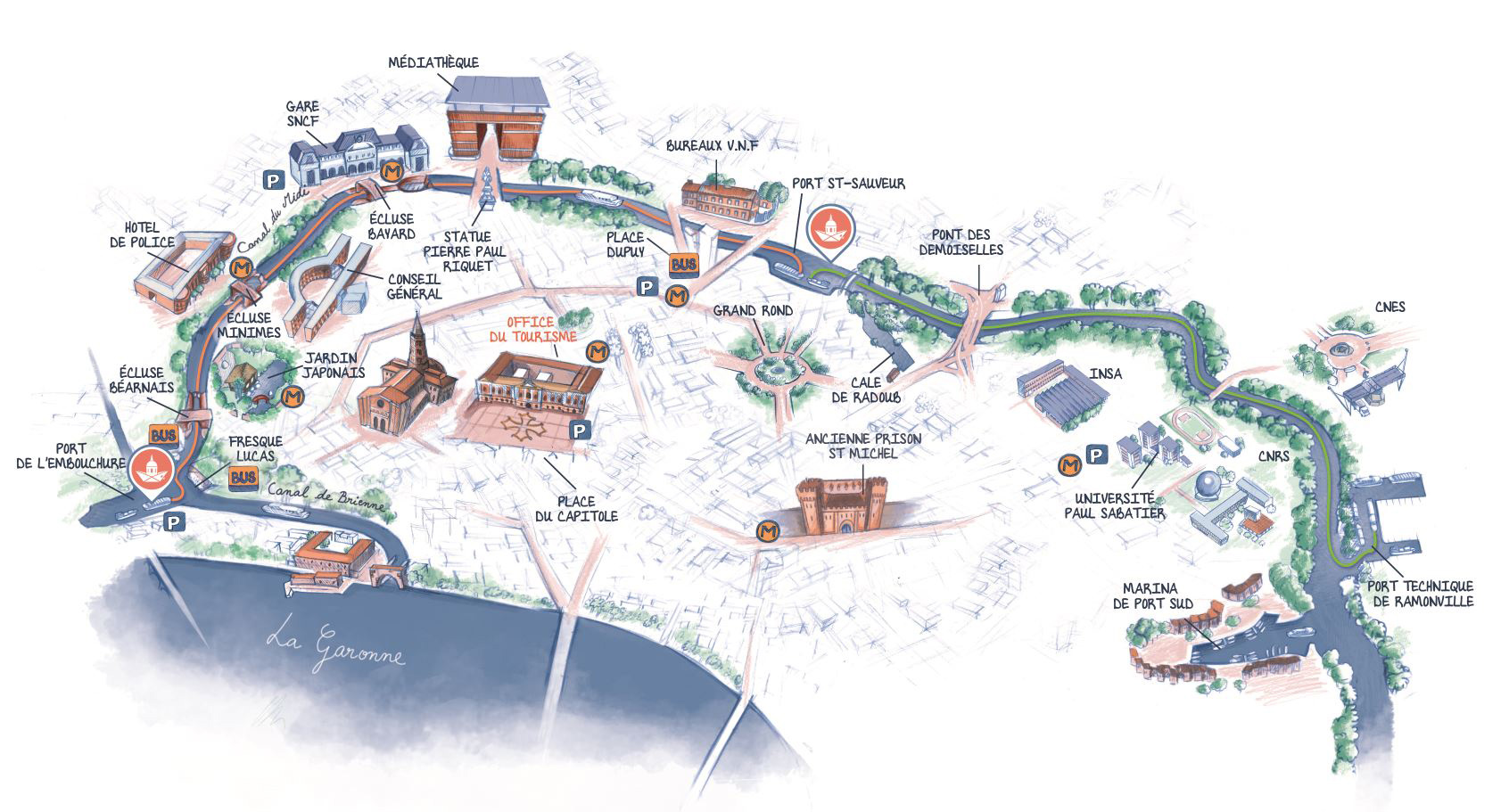
此外,流经卡尔卡松的米迪运河也是法国南部重要的旅游景点之一。除观光业之外,卡尔卡松的经济活动还包括酿酒、纺织、制鞋等行业。
Carcassonne (okzitanisch: Carcassona) ist eine Gemeinde mit 46.031 Einwohnern (Stand 1. Januar 2017) in Südfrankreich und Präfektur des Départements Aude. Sie ist Sitz des Gemeindeverbands Carcassonne Agglo mit über 105.000 Einwohnern. Ihr Wahrzeichen ist die mittelalterliche, auf einem Hügel der Altstadt gelegene, als Cité von Carcassonne bezeichnete Festung.
Carcassonne liegt etwa 70 Kilometer nordwestlich von Perpignan an einer alten Handelsstraße zwischen Mittelmeer und Atlantik. Die Stadt liegt an den Flüssen Aude und Fresquel und wird vom Canal du Midi durchquert.
カルカソンヌ (Carcassonne) は、フランス南部のオクシタニー地域圏ラングドック地方に属するオード県の県庁所在地である。カルカッソンヌとも表記する[1]。古代ローマ時代には要塞に囲まれた都市機能の基盤が形成され、中世にはさらに外側にもう一重の要塞が建設されて、この二重の防備が施された丘の上の城塞都市であるシテ(cité, またはville haute)を核として、オード川をはさんで展開した下街(ville basse)との二層の区域が合わさって発展した欧州最古の城塞都市である。
シテを覆う城塞は19世紀に建築家のウジェーヌ・エマニュエル・ヴィオレ・ル・デュクにより修復されており、シテは「歴史的城塞都市カルカソンヌ」の名で1997年にユネスコの世界遺産に登録された。約40人が暮らす。
街の名前カルカソンヌは、カール大帝がこの都市の攻略をあきらめ退散するときに、当時街を治めていたカルカス (Carcas) が勝利の鐘を鳴らした (sonner) ことに由来するという伝説がある。またこのときに篭城した市民が家庭に残っていた食材である豆、雑穀、豚や腸詰や鴨などの鳥獣肉を持ち寄りまとめて大鍋に入れ煮込んだものがカルカソンヌの名を冠したカスールという鍋料理:カスレのルーツになったと言われている。
Carcassonne (/ˌkɑːrkəˈsɒn/,[2][3] also US: /-ˈsɔːn, -ˈsoʊn/,[4] French: [kaʁkasɔn] (![]() listen), locally: [kaʁkasɔnə]; Occitan: Carcassona [kaɾkaˈsunɔ]; Latin: Carcaso) is a French fortified city in the department of Aude, in the region of Occitanie. A prefecture, it has a population of about 50,000.
listen), locally: [kaʁkasɔnə]; Occitan: Carcassona [kaɾkaˈsunɔ]; Latin: Carcaso) is a French fortified city in the department of Aude, in the region of Occitanie. A prefecture, it has a population of about 50,000.
Inhabited since the Neolithic, Carcassonne is located in the plain of the Aude between historic trade routes, linking the Atlantic to the Mediterranean Sea and the Massif Central to the Pyrénées. Its strategic importance was quickly recognized by the Romans, who occupied its hilltop until the demise of the Western Roman Empire. In the fifth century, it was taken over by the Visigoths, who founded the city. Its strategic location led successive rulers to expand its fortifications until the Treaty of the Pyrenees in 1659.
Its citadel, known as the Cité de Carcassonne, is a medieval fortress dating back to the Gallo-Roman period and restored by the theorist and architect Eugène Viollet-le-Duc in 1853. It was added to the UNESCO list of World Heritage Sites in 1997.[5] Consequently, Carcassonne relies heavily on tourism but also counts manufacturing and winemaking as some of its other key economic sectors.
Carcassonne Écouter est une commune française, préfecture du département de l'Aude dans la région Occitanie.
Au dernier recensement de 2017, la commune comptait 46 031 habitants appelés les Carcassonnais. Carcassonne est la ville principale de la Carcassonne Agglo 111 452 habitants (2016), de l'aire urbaine de Carcassonne 98 318 habitants (2013)1 et de son unité urbaine qui compte 49 257 habitants (2013).
Occupée depuis le Néolithique, Carcassonne se trouve dans la plaine de l'Aude entre deux grands axes de circulation reliant l'Atlantique à la mer Méditerranée et le Massif central aux Pyrénées.
La ville est connue pour la Cité de Carcassonne, ensemble architectural médiéval restauré par Viollet-le-Duc au XIXe siècle et inscrit au patrimoine mondial de l'UNESCO depuis 19972.
Carcassonne (AFI: [kaʁ.ka.sɔn]; in occitano Carcassona), in italiano Carcassona[2][3] (/karkasˈsona/; anticamente Carcasciona[2]) è una città francese situata nel dipartimento dell'Aude, del quale è capoluogo, nella regione dell'Occitania, famosa per la ricostruzione ottocentesca della sua cittadella fortificata in stile medievale.
Carcasona (Carcassonne en francés, Carcassona en occitano) es una comuna francesa, capital del departamento del Aude, en la región de Occitania, situada en el sur de Francia, a medio camino entre Perpiñán y Toulouse.
La ciudad es conocida por su ciudadela amurallada, un conjunto arquitectónico medieval restaurado por Eugène Viollet-le-Duc en el siglo XIX y declarada en 1997 Patrimonio de la Humanidad por la Unesco.7
Каркасон (фр. Carcassonne, окс. Carcassona — произносится [karkasuno]) — французская коммуна, расположенная в департаменте Од на территории региона Окситания. Город Каркассон является префектурой департамента.
Каркассон делится на старый и новый город. Старый, укреплённый город стоит на скалистой возвышенности и окружён двумя стенами V и XIII столетий. В 1997 году средневековый архитектурный ансамбль был включён в список всемирного наследия ЮНЕСКО.
 International cities
 Companies
 History
 World Heritage
 Architecture
 Religion
 Animal world
 Aragón
 Cataluña
 Foral Community of Navarra
 Geography
 Nouvelle-Aquitaine
 Medieval cities in Europe