
Deutsch-Chinesische Enzyklopädie, 德汉百科
 中国
中国
 建筑艺术
建筑艺术

 历史
历史
 宗教
宗教
 文化遗产
文化遗产

大昭寺,又名“祖拉康”、“觉康”(藏语意为佛殿),位于拉萨老城区中心,是一座藏传佛教寺院,是藏王松赞干布建造,拉萨之所以有“圣地”之誉, 与这座佛像有关。寺庙最初称“惹萨”,后来惹萨又成为这座城市的名称,并演化成当下的“拉萨”。大昭寺建成后,经过元、明、清历朝屡加修改扩建,才形成了现今的规模。
大昭寺(藏语:ཇོ་ཁང་,藏语拼音:Qokang,威利:jo khang)是位于中国西藏自治区拉萨市中心的一座藏传佛教寺院,该寺院在藏传佛教中拥有至高无上的地位。2000年,大昭寺作为布达拉宫的扩展项目被列为世界文化遗产。 大昭寺始建于七世纪吐蕃王朝的鼎盛时期,建造的目的据传说是为了供奉一尊不动金刚佛像,即释迦牟尼八岁等身像,该佛像据传是当时的吐蕃赞普松赞干布迎娶的尼泊尔尺尊公主从家乡带去的[1][2]。据说当地原为一座湖泊,但在松赞干布的努力之下,将它填平建为寺院。
之后寺院经历代扩建,目前占地25100余平方米。
值得一提的是,现在大昭寺内供奉的是唐朝文成公主带去的释迦牟尼十二岁等身像,而八岁等身像于八世纪被转供奉在小昭寺,后毁于文化大革命。在大昭寺的泥制大佛之中,安放了尺尊公主带至西藏的木制释迦牟尼佛像,相传松赞干布化身为光芒,进入佛像之中。
由于默朗钦莫及其政教合一的传统,大昭寺在文化大革命期间成为“破四旧”的目标。1966年,红卫兵攻击大昭寺,摧毁了许多佛像[3][4]。一楼松赞干布所建的观音像在文革时被扔到大街上,藏人偷偷保存其愤怒与慈悲的头像各一,后来辗转流传到印度达兰萨拉献给达赖喇嘛,成为楚拉康寺(Tsug Lagkhang)此像复制品的一部分。[5][6]大昭寺成为屠猪场,西藏人被禁止进入膜拜,直至1972年,开始重建大昭寺,1980年完成重建工程。
Der Jokhang[1] ist das bedeutendste Heiligtum innerhalb des Lhasa Tsuglagkhang und liegt inmitten der Altstadt von Lhasa, der Hauptstadt des Autonomen Gebiets Tibet der Volksrepublik China. Für die Tibeter bildet er eine Art Zentralheiligtum, zu dem man nach Möglichkeit mindestens einmal im Leben gepilgert sein sollte.
Der Legende nach wurde der Jokhang im Jahre 639 von König Songtsen Gampos nepalesischer Gemahlin, der Prinzessin Bhrikuti (tib.: khri btsun) errichtet, nachdem der ehemals an dieser Stelle gelegene Milchsee (tib. ’o thang gi mtsho) mit Hilfe der Divination von Songtsen Gampos chinesischer Gemahlin Wen Cheng trockengelegt worden war. Der zwischen 642 und 653 fertiggestellte Bau wurde von den in Begleitung Bhrikutis in das Schneeland gekommenen nepalesischen Künstlern vollendet. Ursprünglich dürfte es sich um ein relativ kleines Gebäude gehandelt haben. Indem die Anlage des Jokhang später – vermutlich insbesondere zur Zeit Tsongkhapas (1357–1419) – um zahlreiche Nebengebäude und weitere Stockwerke erweitert wurde, erhielt sie den Namen Lhasa Tsuglagkhang. Die Gesamtanlage besaß damit eine Fläche von etwa 21.500 m².[2] und bildete von dieser Zeit an die Stätte zur Abhaltung des „Großen Gebetes“ des sogenannten Mönlam Chenmo (tib.: smon lam chen mo).
Während des Aufstandes von 1959 achtete die Volksbefreiungsarmee peinlich darauf, den Tempel nicht zu beschädigen, doch während der Kulturrevolution von 1966 bis 1976 wurde der Jokhang unter Beteiligung der Bevölkerung von Lhasa geplündert und schließlich als Hauptquartier der Roten Garden sowie als Gästehaus und Filmtheater genutzt.[3]
Im Jahr 1981 wurde der Jokhang unter nationalen Denkmalschutz gestellt. Im Jahr 2000 wurde er zusammen mit dem Potala-Palast als „Historisches Ensemble Potala-Palast in Lhasa“ zum UNESCO-Weltkulturerbe erklärt. 2001 kam noch der Norbulingka dazu.
トゥルナン寺(トゥルナンじ)は、中華人民共和国チベット自治区の首府ラサにあるチベット仏教の寺院である[1]。中国名は大昭寺。一般的には本堂に相当する部分の名称であるジョカンと呼ばれることが多い。また、本堂という意味のツクラカンをつけて、トゥルナン・ツクラカンと呼ばれることもある。
正門前では、五体投地で祈る熱心なチベット仏教徒を多く見ることができる。
内部には多くのマニ車を備えた回廊があり、コルラすることが出来る。
本尊は、ソンツェン・ガンポに嫁した唐の玄宗皇帝の娘、文成公主が中国から持参したとされる釈迦牟尼像である。
The Jokhang (Tibetan: ཇོ་ཁང།, Chinese: 大昭寺), also known as the Qoikang Monastery, Jokang, Jokhang Temple, Jokhang Monastery and Zuglagkang (Tibetan: གཙུག་ལག་ཁང༌།, Wylie: gtsug-lag-khang, ZYPY: Zuglagkang or Tsuklakang), is a Buddhist temple in Barkhor Square in Lhasa, the capital city of Tibet. Tibetans, in general, consider this temple as the most sacred and important temple in Tibet. The temple is currently maintained by the Gelug school, but they accept worshipers from all sects of Buddhism. The temple's architectural style is a mixture of Indian vihara design, Tibetan and Nepalese design.
The Jokhang was founded during the reign of King Songtsen Gampo. According to tradition, the temple was built for the king's two brides: Princess Wencheng of the Chinese Tang dynasty and Princess Bhrikuti of Nepal. Both are said to have brought important Buddhist statues and images from China and Nepal to Tibet, which were housed here, as part of their dowries. The oldest part of the temple was built in 652. Over the next 900 years, the temple was enlarged several times with the last renovation done in 1610 by the Fifth Dalai Lama. Following the death of Gampo, the image in Ramcho Lake temple was moved to the Jokhang temple for security reasons. When King Tresang Detsen ruled from 755 to 797, the Buddha image of the Jokhang temple was hidden, as the king's minister was hostile to the spread of Buddhism in Tibet. During the late ninth and early tenth centuries, the Jokhang and Ramoche temples were said to have been used as stables. In 1049 Atisha, a renowned teacher of Buddhism from Bengal taught in Jokhang.
Around the 14th century, the temple was associated with the Vajrasana in India. In the 18th century the Qianlong Emperor of the Qing dynasty, following the Gorkha-Tibetan war in 1792, did not allow the Nepalese to visit this temple and it became an exclusive place of worship for the Tibetans. During the Chinese development of Lhasa, the Barkhor Square in front of the temple was encroached. During the Cultural Revolution, Red Guards attacked the Jokhang temple in 1966 and for a decade there was no worship. Renovation of the Jokhang took place from 1972 to 1980. In 2000, the Jokhang became a UNESCO World Heritage Site as an extension of the Potala Palace (a World Heritage Site since 1994). Many Nepalese artists have worked on the temple's design and construction.
Le temple ou monastère du Jokhang (tibétain : ཇོ་ཁང་, Wylie : jo khang), signifiant « maison du Jowo » en référence à la célèbre statue qu'il abrite, aussi appelé Tsuklakang, est le premier temple bouddhiste construit au Tibet. Cœur spirituel de Lhassa et lieu de pèlerinage depuis des siècles, il est situé dans le quartier du Barkhor.
Depuis 2000, le Jokhang est inscrit au patrimoine mondial de l'UNESCO dans le cadre de l'« ensemble historique du palais du Potala », et il est un des hauts-lieux touristiques de Lhassa avec le palais du Potala et le parc du Norbulingka.
Jokhang è il tempio buddista più importante di Lhasa. Il luogo è ricco di arte tipica del Tibet.
El templo de Jokhang o monasterio de Jokhang es el más famoso de los templos budistas de Lhasa en el Tíbet. Es el centro espiritual de la ciudad y tal vez su atracción turística más famosa. Está considerado por la Unesco como Patrimonio de la Humanidad junto con el Palacio de Potala y el Palacio Norbulingka.
El templo fue construido por el rey Songtsen Gampo, probablemente en 642. En origen su nombre fue Rasa Tulnang Tsuklakang. Tanto Bhirututi como Wencheng, las esposas nepalí y china del rey, aportaron como dote numerosas imágenes budistas que fueron instaladas en este templo. Jochan, junto con el templo de Ramoche, es uno de los primeros construidos en la ciudad así como uno de los más venerados ya que alberga una imagen de Jowo, el joven Buda que se dice fue esculpida en vida de Siddhārtha Gautama.
Se trata de una construcción de cuatro pisos, con tejados cubiertos con azulejos de bronce dorado. El estilo arquitectónico está basado en el diseño vihara de la India que más tarde se transformó en una mezcla entre el estilo nepalí y el de la dinastía Tang. En el tejado se encuentra unas estatuas de dos ciervos dorados que flanquean una rueda de dharma.
El complejo del templo tiene numerosos altares y habitaciones decoradas. La sala principal de los edificios del templo alberga la estatua de Jowo. También hay estatuas del rey Songtsan Gambo así como de sus dos esposas. Durante la revolución cultural se destruyeron numerosas de estas esculturas que se han reconstruido utilizando en algunos casos partes rotas de las estatuas originales.
Frente al templo se encuentra una zona cerrada que contiene algunos sauces llamados Jowo Utra (cabello del Jowo) así como un pilar erigido por los chinos en 1793 durante una epidemia de viruela. En él está grabado el tratado sino-tibetano firmado en 822, hecho cumplir por el emperador Ralpacan. El texto incluye algunas medidas de higiene para prevenir la infección de viruela.1
Джоканг (тиб. ཇོ་ཁང, Вайли Jo-khang; кит. упр. 大昭寺, пиньинь: Dàzhāosì) в городе Лхасе в Тибете — буддийский храм и монастырь, особо почитаемый тибетцами. Сюда сходятся многочисленные паломники и зарубежные туристы. Как часть общего комплекса храмов в Лхасе, является охраняемым объектом Всемирного Наследия ЮНЕСКО.
Джоканг начал строить царь Тибета Сонгцен Гампо в 639 году. Китайская принцесса Вэньчэн исследовала местность с помощью геомантии (фэншуй)[1]. На месте храма располагалось тогда небольшое озеро. Принцесса отождествила местность с телом огромной демоницы, озеро — с её гениталиями, а сердце — c тем местом, где сейчас находится храм Потала. Царь приказал осушить озеро и построить храм, а вокруг воздвигнуть ступы и монастыри, чтобы пригвоздить демоницу к земле и обезвредить.
 地理
地理

 美食家
美食家
 国际城市
国际城市


开封(英文:Kaifeng)古称老丘、启封、大梁、浚仪、汴京、汴梁等,简称汴,河南省地级市,地处河南省中东部,西与省会郑州市毗邻,东与商丘市相连,南接许昌市和周口市,北隔黄河与新乡市相望。截至2016年,开封市总面积6266平方公里,下辖5个市辖区、4个县,常住454.67万人。
开封迄今已有4100余年的建城史和建都史,先后有夏朝,战国时的魏国,五代时期的后梁、后晋、后汉、后周及北宋相继在此定都,北宋称此为东京开封府。开封是世界上唯一一座城市中轴线从未变动的都城,城摞城遗址在世界考古史和都城史上少有。北宋首都东京开封府更是当时继唐朝首都长安后的世界第一大城市。有着“琪树明霞五凤楼,夷门自古帝王州”、“汴京富丽天下无”的美誉。开封是清明上河图的创作地,有“东京梦华”之美誉。
开封是戏曲之乡,中国第一大地方剧种豫剧发源于此。开封市内五湖四河环绕分布,素有“北方水城”之称。开封是中国优秀旅游城市、中国菊花名 城、中国书法名城,拥有国家5A、4A级旅游景区8家,全国重点文物保护单位19处。中国开封清明文化节 、中国开封菊花文化节吸引著众多海内外游客。
开封是河南省新兴副中心城市、中原城市群核心发展区城市,郑州大都市区核心城市。开封自贸区也是中国(河南)自由贸易试验区三大片区之一。
Kâifêng (Aussprache allerdings eher wie "Kaifong") ist eine mit einer halben Million Einwohner verhältnismässig kleine Stadt und befindet sich wie auch →Luòyáng in der Provinz Hénán. Schon vor Beginn der Tang-Dynastie im 7. Jhd. war die Stadt einmal Hauptstadt. Später, zwischen dem 10. und 12. Jhd., diente sie ebenfalls einigen Kaisern als Hauptstadt.
Die Stadt hatte Zugang zum nahe gelegenen Huang He (Gelber Fluss), und lag damit zwischen den wohlhabenden Städten an der Ostküste und den wichtigen Städten Kâifêng und →Xî'ân im Westen.
Die Stadt hatte um die Jahrtausendwende herum schätzungsweise eine Million Einwohner - mehr als heute. Im Jahre 1644 gab es einen erheblichen Einschnitt: Die Mandschuren bekämpften die Truppen der Ming-Dynastie und rückten immer weiter gen Süden vor. Um die Eroberer zu stoppen, beschloss man die Deiche des Huang He zu öffnen und damit Kâifêng zu opfern. Das hat angeblich ca. 300'000 Einwohnern das Leben gekostet. Dazu muss man wissen, dass der Huang He sich mit seiner enormen Lössfracht ein Bett geschaffen hat, das höher als das Umland liegt: Das Umland ist durch natürliche Dämme geschützt - wenn die allerdings zerstört werden, kommt (kam) es zur Katastrophe.
Heute ist die Stadt angenehm ruhig. Die grossen Parkanlagen und ein altes, gut erhaltenes historisches Zentrum machen es möglich, China einmal anders zu erleben.(Quelle:www.tabibito.de/china/kaifeng.html)
Kaifeng (chinesisch 開封市 / 开封市, Pinyin Kāifēng Shì) ist eine bezirksfreie Stadt in der chinesischen Provinz Henan. Ihr Verwaltungsgebiet hat eine Fläche von 6.247 km² und ca. 4,7 Millionen Einwohner (Zensus 2010). In dem eigentlichen städtischen Siedlungsgebiet von Kaifeng leben 894.142 Menschen (Zensus 2010). Kaifeng liegt am Gelben Fluss. Die Entfernung zu Zhengzhou, der Hauptstadt der Provinz, beträgt etwa 70 Kilometer. Kaifeng ist eine der alten Hauptstädte in der Geschichte Chinas.
開封市(かいほうし、簡体字: 开封市; 繁体字: 開封市; ピン音: Kāifēng; ウェード式: K'aifeng)は中華人民共和国河南省東部に位置する地級市。中国でも最も歴史が古い都市の一つであり、北宋の首都であった。11世紀から12世紀にかけて世界最大級の都市であった[1]。
Kaifeng (simplified Chinese: 开封; traditional Chinese: 開封), known previously by several names, is a prefecture-level city in east-central Henan province, China. It is one of the Eight Ancient Capitals of China, for being the capital seven times in history, and is most famous for being the capital of China in the Northern Song dynasty.
There are currently about 5 million people living in its metropolitan area. Located along the southern bank of the Yellow River, it borders the provincial capital of Zhengzhou to the west, Xinxiang to the northwest, Shangqiu to the east, Zhoukou to the southeast, Xuchang to the southwest, and Heze of Shandong to the northeast.
Kaifeng (开封 ; pinyin : Kāifēng), anciennement connu sous le nom de Bianliang (汴梁 ou 汴樑; pinyin: Biànliáng), Bianjing (汴京 ; pinyin: Biànjīng), Daliang (大梁 ou 大樑 ; pinyin: Dàliáng), ou simplement Liang (梁 ou 樑 ; pinyin: Liáng), est une ville-préfecture de l'est de la province du Henan en Chine. Elle fut capitale impériale sous la dynastie Song du Nord (960-1127).
Kaifeng (in cinese: 開封T, 开封S, KāifēngP) è una città-prefettura della Repubblica Popolare Cinese, della provincia dello Henan. Fu una delle capitali storiche della Cina durante alla dinastia Song, che la abbandonò a seguito di un'invasione e per circa 900 anni fu sede di una comunità ebraica, l'unica conosciuta in Cina prima del XIX secolo.
Kaifeng léase Kái-Feng (chino simplificado: 开封市, chino tradicional: 開封市, pinyin: Kāifēngshí) es una ciudad en la provincia de Henan, en la República Popular China. Está situada a orillas del río Amarillo y a unos 70 kilómetros de la capital provincial, Zhengzhou. La ciudad cuenta con una población de casi 5.000.000 de habitantes (2010) que viven en un área de 6444 km².
 企业
企业
 能源
能源

 科学技术
科学技术


大运河南起余杭(今杭州),北到涿郡(今北京),途经今浙江、江苏、山东、河北四省及天津、北京两市,贯通海河、黄河、淮河、长江、钱塘江五大水系,全长约1797公里。运河对中国南北地区之间的经济、文化发展与交流,特别是对沿线地区工农业经济的发展起了巨大作用。
Der Kaiserkanal im Osten von China verläuft von der Stadt Hangzhou bis in die Hauptstadt des Landes, Peking. Die Stadt Hangzhou liegt in der Nähe von Shanghai und der Mündung des Changjiang-Flusses (im Westen oft auch Yangtsekiang-Fluss genannt), über Jahrtausende einer der fruchtbarsten Regionen Chinas. Die chinesischen Kaiser ließen den Großen Kanal anlegen, um Tributzahlungen und Naturalien-Steuern aus dem Süden des Landes in die Hauptstadt zu transportieren.
Auf chinesische heißt der Kaiserkanal 京杭大运河 Jing-Hang Da Zunhe, was übersetzt "Großer Beijing-Hangzhou Kanal" heißt. Im Westen wird der künstliche Fluss dagegen meist als Großer Kanal oder auch Kaiserkanal bezeichnet. Mit über 1800 Kilometern Gesamtlänge ist der Kaiserkanal die größte von Menschen geschaffene Wasserstraße der Welt. Der im Verlauf von vielen Jahrhunderten immer wieder ausgebaute Große Kanal ist teilweise bis zu 40 Metern breit und bis zu 9 Metern tief.(Quelle: http://www.forumchina.de/kaiserkanal)
Der Kaiserkanal (chinesisch 京杭大运河, Pinyin Jīng Háng Dà Yùnhé, d. h. Peking-Hangzhou Großer Kanal) ist die längste von Menschen geschaffene Wasserstraße der Welt. Mit einer Länge von mehr als 1800 Kilometern und einer Breite von bis zu 40 Metern verband er den Norden Chinas (Peking) mit dem fruchtbaren Mündungsgebiet des Jangtsekiang (Hangzhou). Er überwand einen Höhenunterschied von 42 Metern, war 3 bis 9 Meter tief und gilt als das Meisterwerk der Wasserbaukunst im alten China. Seit 2014 gehört er daher zum Welterbe der Menschheit.
京杭大運河(けいこうだいうんが)は、中国の北京から杭州までを結ぶ、総延長2500キロメートルに及ぶ大運河である。途中で、黄河と揚子江を横断している。戦国時代より部分的には開削されてきたが、隋の文帝と煬帝がこれを整備した。完成は610年。運河建設は人民に負担を強いて隋末の反乱の原因となったが、運河によって経済の中心地江南と政治の中心地華北、さらに元のクビライ・ハーンによって軍事上の要地である涿郡だった大都(後の北京)が結合して、中国統一の基盤が整備された。この運河は、その後の歴代王朝でもおおいに活用され、現在も中国の大動脈として利用されている。2014年の第38回世界遺産委員会でシルクロードなどとともに世界遺産リストに登録された。
The Grand Canal, known to the Chinese as the Beijing–Hangzhou Grand Canal (Jīng-Háng Dà Yùnhé), a UNESCO World Heritage Site, is the longest as well as the oldest canal or artificial river in the world and a famous tourist destination.[1] Starting at Beijing, it passes through Tianjin and the provinces of Hebei, Shandong, Jiangsu and Zhejiang to the city of Hangzhou, linking the Yellow River and Yangtze River. The oldest parts of the canal date back to the 5th century BC, but the various sections were first connected during the Sui dynasty (581–618 AD). Dynasties in 1271-1633 significantly rebuilt the canal and altered its route to supply their capital Beijing.
The total length of the Grand Canal is 1,776 km (1,104 mi). Its greatest height is reached in the mountains of Shandong, at a summit of 42 m (138 ft).[2] Ships in Chinese canals did not have trouble reaching higher elevations after the pound lock was invented in the 10th century, during the Song dynasty (960–1279), by the government official and engineer Qiao Weiyue.[3] The canal has been admired by many throughout history including Japanese monk Ennin (794–864), Persian historian Rashid al-Din (1247–1318), Korean official Choe Bu (1454–1504), and Italian missionary Matteo Ricci (1552–1610).[4][5]
Historically, periodic flooding of the Yellow River threatened the safety and functioning of the canal. During wartime the high dikes of the Yellow River were sometimes deliberately broken in order to flood advancing enemy troops. This caused disaster and prolonged economic hardships. Despite temporary periods of desolation and disuse, the Grand Canal furthered an indigenous and growing economic market in China's urban centers since the Sui period. It has allowed faster trading and has improved China's economy. The southern portion remains in heavy use to the present day.
Le Grand Canal (chinois simplifié : 大运河 ; chinois traditionnel : 大運河 ; pinyin : ) de Chine, également connu sous le nom de Grand Canal Pékin-Hangzhou (chinois simplifié : 京杭大运河 ; chinois traditionnel : 京杭大運河 ; pinyin : ) est le plus grand canal ancien ou rivière artificielle du monde (1 794 km). Les parties les plus anciennes remontent au Ve siècle av. J.-C.. Il est inscrit au patrimoine mondial de l'UNESCO depuis 20141.
Il Gran Canale della Cina, conosciuto anche come Gran Canale Jing-Hang e Canale Imperiale, è il canale o fiume artificiale più lungo del mondo e collega Pechino, passando per Tianjin e le provincie di Hebei, Shandong, Jiangsu e arrivando a Hangzhou nello Zhejiang e collega il fiume giallo e il fiume azzurro in Cina[1].
El Gran Canal de China (chino tradicional: 大運河, chino simplificado: 大运河, pinyin: Dà Yùnhé), conocido también como Gran Canal Pekín-Hangzhou (chino tradicional: 京杭大運河, chino simplificado: 京杭大运河, pinyin: Jīng Háng Dà Yùnhé) es el canal o río artificial más largo del mundo.1
En junio de 2014, la Unesco eligió el Gran Canal de China como Patrimonio de la Humanidad.2
En el año 604, el emperador Yang Guang de la dinastía Sui dejó la capital, Chang'an (en Xian) para trasladarse a Luoyang. En 605, el emperador ordenó la construcción de dos proyectos: transferir la capital del país a Luoyang (en Henan) y excavar el Gran Canal entre Pekín y Hangzhou.
En su origen se trataba de una serie de vías hidráulicas en la provincia Cheklang, al norte de China, que convergían con la ciudad de Pekín y Tianjin, atravesando las provincias de Hebeng, Shandong, Jiangsu y Zhejiang.
La construcción comenzó durante la dinastía Sui (581-618) y llegó a cubrir poco más de 1.700 kilómetros. Su nombre original era Da Yunhe, y en su tiempo constituyó el canal de agua más largo del mundo hecho por el hombre. Su misión era satisfacer las necesidades de las ciudades importantes con el agua de los ríos Yangste y Hual; permaneció en activo hasta el siglo XIX y después sufrió una serie de modificaciones, que en muchos casos culminaron en desastrosas inundaciones, y varias secciones se deterioraron hasta quedar separadas del cuerpo principal del canal.
Actualmente está dividido en siete subcanales, algunos de ellos muy contaminados, para el servicio exclusivo de aguas negras en desuso o con niveles insuficientes para la navegación. Pero los más grandes, como el canal Li y el Jiangnan son utilizados actualmente para el transporte de carbón y otros materiales; se estima que anualmente se mueven 100 millones de toneladas de carga.
Вели́кий кана́л[1] (кит. трад. 大運河, упр. 大运河, пиньинь: Dà Yùnhé — Даюньхэ[2]) — судоходный канал в Китае, одно из древнейших ныне действующих гидротехнических сооружений мира.
Строился в течение двух тысяч лет — с VI в. до н. э. до XIII в. н. э.[3] В настоящее время является одной из важнейших внутренних водных артерий КНР, соединяет крупные порты страны Шанхай и Тяньцзинь.
Протяжённость канала — 1782 км[4], а с ответвлениями в Пекин, Ханчжоу и Наньтун — 2470 км. Ширина в наиболее узкой части в провинциях Шаньдун и Хэбэй — 40 м, в самой широкой части в Шанхае — 350 м. Глубина фарватера — от 2 до 3 м. Канал оборудован 21 шлюзом. Максимальная грузопропускная способность составляет 10 млн тонн в год.
Канал соединяет реки Хуанхэ и Янцзы, включая в себя русла таких рек, как Байхэ, Вэйхэ, Сышуй и других, а также несколько озёр.
Великий канал состоит из нескольких сооружённых в разное время участков. Самый южный участок проложен в VII веке, самый северный — в XIII веке, а часть центрального участка от Хуайинь до Цзянду проходит по древнему каналу Ханьгоу.
Астронавт Уильям Поуг, будучи на борту Скайлэба, первоначально подумал, что увидел Великую Китайскую стену, но оказалось, что он видел Великий канал Китая[5].
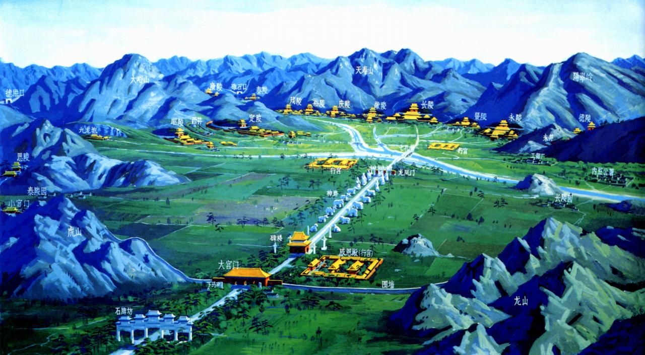
明朝,从太祖朱元璋推翻元朝政权,建元洪武(1368),到崇祯十七年(1644)被李自成领导的农民起义军推翻,统治时间277年,其间经历了16位皇帝。其中,除惠帝朱允炆因“靖难之役”,下落不明,没有营建陵园外,其余15帝,都依帝制建造了陵园。
满族人建立的清朝(1644-1911)是中国最后一个封建王朝。自清太祖努尔哈赤开基至辛亥革命后宣统皇帝退位,共历经12帝,统治295年。清代帝王陵寝,从建陵年代和地理位置,可分为清初关外三陵、清东陵和清西陵三个陵区。清东陵和西陵的陵墓从规划建制到建筑造型均仿照明朝,采用集中陵区的手法,安排总入口,从正红门开端,经统一的神道石像生、碑亭及华表,然后分达各陵区。其布局顺序为:五孔石券桥、牌楼、碑亭、三孔券桥,大月台、宫门、隆恩殿及左右配殿,而后为石平桥、月台、琉璃门、五供、方城(上立明楼)、月牙城、宝城、宝顶。皇帝、皇后、亲王、公主、嫔妃的陵制级别相当严格,形成了一套程式化的规则。
Die Kaisergräber der Ming- (1368-1644) und Qing-Dynastie (1644-1911) sind durch Einfluss des Menschen veränderte Naturstätten. Sorgfältig ausgewählt auf Basis der Geomantie (Fengshui) handelt es sich bei diesen um Bauten mit traditionellem Architekturdesign und Dekor. Verkörpert wird die bereits über fünf Jahrhunderte existierende Weltanschauung und das Machtkonzept des feudalen China.
Das Xian-Grab aus der Ming-Dynastie ist die Grabstätte von Fürst Xingxian und dessen Ehefrau, Eltern des Kaisers Jiaqing (Regierungszeit: 1522-1566). Die beiden wurden im heutigen Kreis Zhongxiang (Provinz Hubei) auf dem Berg Songlin gemeinsam bestattet. Das Grab mit einer Fläche von 136,47 Hektar ist durch hohe Mauern umgeben. Das Xian-Grab, dessen Bau 1519 begann und 1540 abgeschlossen wurde, ähnelt den Ming-Gräbern in der Nähe Beijings, ist jedoch flächenmäßig größer. Es gilt als das einzige Ming-Grab, das jemals in Südchina entdeckt wurde und wird oft als das 15. Ming-Grab bezeichnet. 1985 wurde das Grab unter staatlichen Schutz gestellt.
(Quelle:http://german.beijingreview.com.cn/)
Die Kaiserlichen Grabstätten der Ming- und der Qing-Dynastien (明清皇家陵寢 / 明清皇家陵寝, Míng qīng huángjiā língqǐn) sind mehrere Grabanlagen der Kaiser Chinas und ihrer Ehefrauen, welche im 15. bis 18. Jahrhundert in der Zeit der Ming-Dynastie (1368–1644) bzw. Qing-Dynastie (1644–1911) entstanden. Die Grabstätten sind über mehrere Regionen Chinas verteilt. Die UNESCO beschreibt die Bedeutung der Gräber mit fünf Kriterien: die Gräber seien ein meisterhaftes Beispiel der Integration von Architektur und natürlicher Umgebung nach den Grundsätzen des Fengshui. Sie repräsentierten die Weiterentwicklung früherer Kunstformen in der Ming- und Qing-Zeit und seien hervorragende Zeugnisse einer kulturellen und architektonischen Tradition, welche über 500 Jahre diese Weltregion geprägt habe. Die Verbindung zwischen Architektur und Natur forme eine einmalige Kulturlandschaft; die Gräber illustrierten die Weltsicht, den Glauben und die geomantischen Prinzipien des feudalen Chinas.[2]
明・清王朝の皇帝墓群(みん・しんおうちょうのこうていぼぐん)は、中国の古代王朝である明と清ならびに清の前身後金の25人の皇帝の陵墓を含む、ユネスコの世界遺産(文化遺産)に登録された物件の総称。2000年に最初の3件が登録されたのち、2003年と2004年に数件ずつの追加登録がなされている。
Imperial Tombs of the Ming and Qing Dynasties (simplified Chinese: 明清皇家陵寝; traditional Chinese: 明清皇家陵寢; pinyin: Míng Qīng Huángjiā Língqǐn) is the designation under which the UNESCO has included several tombs and burial complexes into the list of World Heritage Sites (WHS). These tombs date from the Ming and Qing dynasties of China.
Tombs were included in the list in 2000, 2003 and 2004. Three Imperial tombs in Liaoning Province, all built in the 17th century, were added in 2004: the Yongling tomb, the Fuling tomb and the Zhaoling tomb were constructed for the founding emperors of the Qing dynasty and their ancestors. These tombs feature rich decoration of stone statues and carvings and tiles with dragon motifs, illustrating the development of the funerary architecture of the Qing dynasty. The three tomb complexes, and their numerous edifices, combine traditions inherited from previous dynasties and new features of Manchu culture.
« Tombes impériales des dynasties Ming et Qing » est la désignation sous laquelle l'UNESCO a mis plusieurs complexes de tombes impériales sur la liste du patrimoine mondial en 2000, 2003, et 2004. La dynastie Ming a régné sur la Chine de 1368 à 1644. Sur les seize empereurs de la dynastie, treize sont enterrés dans une nécropole à cinquante kilomètres au nord-ouest de Pékin et à dix kilomètres au nord de Changping. L'initiateur du projet fut le troisième empereur Ming, Yongle, qui à partir de 1407 recherchait un site près de Pékin, sa nouvelle capitale. La dynastie Qing a régné sur la Chine de 1644 et 1912. Il existe deux nécropoles situées à l'est de Pékin. Dans chacune d'elles se trouvent les sépultures de cinq empereurs Qing.
Tombe imperiali delle dinastie Ming e Qing sono il nome in cui vengono raggruppate un insieme di 14 sepolture risalenti alle dinastie Ming e Qing, inserite nell'elenco dei Patrimoni dell'umanità dell'UNESCO.
Tumbas imperiales de las dinastías Ming y Qing es el nombre bajo el cual la Unesco inscribió varios conjuntos de tumbas imperiales en la lista del Patrimonio de la Humanidad en 2000, 2003, y 2004
Гробницы императоров династии Мин и Цин — памятник Всемирного наследия ЮНЕСКО, состоящий из нескольких мавзолейных комплексов в разных районах Китая, где были похоронены императоры династий Мин и Цин, в совокупности правивших Китаем более 500 лет (1368—1911 гг).

沈阳故宫,位于沈阳市沈河区明清旧城中心,是后金、满清入关前的沈阳(盛京)皇宫,满清入关迁都北京后改为盛京行宫(或称奉天行宫) ,始建于1625年。乾隆帝时期又有较大规模的改建与增修,占地约6万平方米。1926年以后,其建筑群陆续辟作博物馆(现称沈阳故宫博物院) 。
入关前
后金天命十年(1625年)三月,后金汗努尔哈赤将都城从东京迁移至明沈阳中卫城,同年开始在沈阳中卫城中心部位偏东南角的位置修筑宫殿[1],即现存的大政殿和十王亭。这组建筑主要是作为理政和朝贺的场所,努尔哈赤居住的寝宫在原沈阳城的北门——安定门。
1626年,皇太极继承后金汗位。从1631年起,用5年的时间对盛京城和皇宫进行改建。他在其原来王府的基础上修建新的大内宫殿,并将原沿袭自沈阳中卫城的十字形街道系统改为井字形街道系统,从而将皇宫置于城池的中央[2]。
1636年,皇太极在此去汗号称帝,改国号为清 ,对沈阳宫殿各主要建筑分别正式命名:“定宫殿名,中宫为清宁宫、东宫为关雎宫、西宫为麟趾宫、次东宫为衍庆宫、次西宫为永福宫、台东楼为翔凤楼、台西楼为飞龙阁、正殿为崇政殿、大门为大清门、东门为东翼门、西门为西翼门、大殿为笃恭殿”[3]。此后又在大清门前东、西两侧分别建文德坊、武功坊两座牌坊,因坊心有“崇德二年孟春吉日立” ,可知建成于1637年。这也是清入关前唯一有确切年代记载的宫殿。
入关后
顺治元年八月二十日,清世祖离开盛京前往北京。在清朝入关定都北京后,沈阳故宫失去了作为皇宫的地位,成为陪都行宫。康熙帝和乾隆帝东巡祭祖期间,曾在此居住。乾隆四十六年,即1780年,增建了西路建筑,包括戏台嘉荫堂和用于储藏四库全书的文溯阁,并在中路修建了东所、西所和盛京太庙。以及对某些入关前宫殿的局部进行改造,其中比较重要的一处是崇政殿,因皇帝东巡时在此举行典礼,但殿内屏风宝座等均系皇太极时遗留,不便使用,所以乾隆皇帝命重新制作。乾隆九年,又命于殿前增设日晷、嘉量。文溯阁等西路宫殿建成后,直到终清之时这里的建筑未再有明显变化。
The Mukden Palace (simplified Chinese: 盛京宫殿; traditional Chinese: 盛京宮殿; pinyin: Shèngjīng Gōngdiàn), or Shenyang Imperial Palace (simplified Chinese: 沈阳故宫; traditional Chinese: 瀋陽故宮; pinyin: Shěnyáng Gùgōng), was the former imperial palace of the early Manchu-led Qing dynasty. It was built in 1625, and the first three Qing emperors lived there from 1625 to 1644. Since the collapse of imperial rule in China, the palace has been converted to a museum that now lies in the center of Shenyang, Liaoning.
Le palais de Mukden (chinois simplifié : 盛京宫殿 ; chinois traditionnel : 盛京宮殿 ; pinyin : ) ou palais de Moukden ou Shenyang Gugong (chinois simplifié : 沈阳故宫 ; chinois traditionnel : 瀋陽故宮 ; pinyin : ), également connu sous le nom de palais impérial de Shenyang, est le premier palais occupé par les empereurs de la dynastie Qing, avant leur installation dans la Cité interdite de Pékin. Il est construit en 1625 et les trois premiers empereurs de la dynastie Qing y vivent de 1625 a 1644. Depuis la fin du régime impérial chinois, le palais a été converti en un musée, qui accueille chaque année 1.6 million de visiteurs2. Il est situé à Shenyang (Moukden en mandchou) en Chine.
Les édifices qui le composent sont inscrits au patrimoine mondial de l'UNESCO et sont également protégés en Chine, par la liste des sites historiques et culturels majeurs protégés au niveau national, au Liaoning sous le no 1-112.
Il Palazzo Mukden (in cinese: 盛京宮殿T, 盛京宫殿S, Shěngjīng GōngdiànP), chiamato anche Shenyang Gugong (瀋陽故宮T, 沈阳故宫S, Shěnyáng GùgōngP), è l'antico palazzo imperiale della dinastia Qing (1616 - 1910). Si trova nel centro della città cinese di Mukden, oggi Shenyang, in Manciuria.
Il palazzo si estende su una superficie di circa 70.000 metri quadrati e consta di 70 edifici, a loro volta composti da 300 stanze.
El Palacio Mukden (en chino tradicional, 盛京宮殿; en chino simplificado, 盛京宫殿; pinyin, Shěngjīng Gōngdiàn) o Shenyang Gugong (en chino tradicional, 瀋陽故宮; en chino simplificado, 沈阳故宫; pinyin, Shěnyáng Gùgōng), también conocido como el Palacio Imperial Shenyang, es un antiguo palacio imperial de la nueva Dinastía Qing (1616-1910) de China.
Fue construido en 1625 y los tres primeros emperadores Qing vivieron allí de 1625 a 1644. Está situado en el centro de la ciudad de Shenyang, Manchuria, China.
Мукденский дворец (кит. трад. 瀋陽故宮, упр. 沈阳故宫) — дворец первых императоров Маньчжурской династии Китая — Нурхаци и Абахая. Заложен Нурхаци в 1625 году в Шэньяне (он же Мукден; исторически Южная Маньчжурия, к северо-востоку от Пекина). Первые здания по архитектурному решению напоминали юрты. К 1631 году строительство дворцового комплекса с учётом дополнительных построек Абахая в основном завершилось. Это комбинация элементов маньчжурской, китайской и тибетской архитектуры.
После завоевания Пекина в 1644 году император переехал в Запретный город, однако он и его наследники продолжали ежегодно посещать Мукден.
В 1780 году дворцовый комплекс был расширен императором Цяньлуном и приобрёл в большей степени облик традиционного китайского дворцового комплекса.
В 1900 году дворец был занят российской армией под командованием Деана Субботича, направленной против повстанцев-ихэтуаней.
В 1955 году объявлен национальным музеем. В 2004 году вошёл в число памятников Всемирного наследия ЮНЕСКО как часть комплексного объекта «Дворцы императоров династий Мин и Цин в Пекине и Шэньяне».

Die Verbotene Stadt war ein faszinierendes Erlebnis, zum einen wegen ihrer großartigen Architektur und zum anderen wegen ihrer unglaublichen Dimension. Direkt im Herzen von Peking nimmt die alte Kaiserstadt eine Fläche von 72 ha ein, auf der sich 890 Tore und Paläste sowie zahllose Pavillons mit insgesamt 9999,5 Räumen befinden - der Legende nach ein Raum weniger als der Palast im Himmel. Die gesamte Anlage ist von einem 52 Meter breiten und 6 Meter tiefen Graben sowie einer zehn Meter hohen und 3.400 Meter langen Stadtmauer mit Wachtürmen umgeben.
Der Bau des Palast-Komplexes dauerte von 1406 bis 1420. Bis zur Revolution im Jahre 1911 lebten und regierten hier 24 Kaiser der Ming und Qing Dynastien. Auf diese Weise beherbergt die Verbotene Stadt zahlreiche Kunstschätze sowie eine Vielzahl gut erhaltener architektonischer Meisterwerke dieser Zeit. Der Kaiserpalast ist bei der UNESCO als das größte und bedeutendste architektonische Palast-Ensemble in China gelistet und ist eine der bekanntesten Touristenattraktion weltweit, was leider dazu führt, dass sich Tausende von Menschen um die Paläste drängen und es wirklich einiger Anstrengung bedarf, über die Absperrung hinweg einen Blick in das Innere zu werfen.(Quelle:http://www.sights-and-culture.com/china/verbotene-stadt.html)
 重要港口
重要港口

Kaohsiung (chinesisch 高雄市, Pinyin Gāoxióng Shì, Tongyong Pinyin Gaosyóng Shìh, W.-G. Kao-hsiung Shih, Pe̍h-ōe-jī Ko-hiông-chhī, Japanisch: Takao) ist die zweitgrößte Stadt Taiwans. Sie ist eine von sechs regierungsunmittelbaren Städten Taiwans und in 38 Bezirke unterteilt.
Kaohsiung liegt im Südwesten der Insel Taiwan am Südchinesischen Meer und verfügt über den wichtigsten Hafen des Landes. Hier wird der größte Teil der taiwanischen Ölimporte abgewickelt, die von der umliegenden Industrie verarbeitet werden.
高雄市(カオションし/たかおし[1]、中国語: 高雄市、英語: Kaohsiung)は、台湾南部に位置する中華民国の直轄市。1979年7月1日、台湾省管轄下の省轄市から直轄市に昇格し、2010年12月25日に高雄県を統合した。台湾地区最大の面積を有する都市で、人口おおよそ277.3万、台湾第3の都市である。
Kaohsiung (Hokkien POJ: Ko-hiông; Hakka PFS: Kô-hiùng; old names: Takao, Takow, Takau) is a coastal city in southern Taiwan. It is officially a special municipality with an area of 2,952 km2 (1,140 sq mi) stretching from the coastal urban centre to the rural Yushan Range. As of 2018, the municipality has a population of 2.77 million persons, making it the third most populous administrative division in Taiwan.[4]
Since founding in the 17th century, Kaohsiung has grown from a small trading village into the political and economic centre of southern Taiwan, with key industries such as manufacturing, steel-making, oil refining, logistics and shipbuilding. It is classified as 'High Sufficiency' by GaWC, with some of the most prominent infrastructures in Taiwan. The Port of Kaohsiung is the largest and busiest harbour in Taiwan while Kaohsiung International Airport is the second busiest airport in number of passengers. The city is well-connected to other major cities by high speed and conventional rail, as well as several national freeways. It also hosts the Republic of China Navy fleet headquarters and its naval academy. More recent public works such as Pier-2 Art Center, National Kaohsiung Center for the Arts and Kaohsiung Music Center have been aimed at growing the tourism and cultural industries of the city.
Kaohsiung (chinois traditionnel : 高雄 ; pinyin : ; pe̍h-ōe-jī : Ko-hiông) est une municipalité spéciale de Taïwan, avec environ 2 775 318 habitants, répartis dans 11 districts.
Dans les années 1990 et au début des années 2000, avant la mise en service du High Speed Rail (HSR, le TGV taiwanais), 126 vols par jour la reliaient à Taipei, ce qui constitue un record mondial pour une distance assez courte de 350 km.
Le maire de la ville depuis le 9 décembre 2006 est Chen Chu.
La municipalité, avec 2,78 millions d'habitants, est la 3e ville la plus importante de Taiwan après New Taipei et Taichung.
Kaohsiung (高雄S, GāoxióngP, Kao-hsiungW) è la seconda città per grandezza di Taiwan, con un popolazione stimata intorno ai 2.770.000 abitanti, divisi negli undici distretti.
Kaohsiung è il centro più importante per la manifattura, la raffinazione ed i trasporti della nazione. Il tasso d'inquinamento è alto data la presenza massiccia di industrie. Kaohsiung è inoltre il centro portuale del paese che si occupa di export (alluminio, legname, carta, fertilizzanti, cemento, metalli, macchinari e navi). Il suo porto è sceso al dodicesimo posto in ordine di grandezza al mondo (dati MOTC 2009), dopo aver occupato la terza posizione nel corso degli anni '80. Kaohsiung è il centro dell'industria navale di Taiwan, nonché il quartier generale della Marina Militare Taiwanese.
Kaohsiung ha ospitato i World Games del 2009, un evento multisportivo che includeva sport non facenti parti dei Giochi olimpici. La città è dotata della stazione terminale della linea ad alta velocità che la collega, anche con treni diretti, a Taipei. Ci sono anche 2 linee di metropolitana molto moderne, dotate di 38 stazioni di cui si progetta l'ampliamento, che garantisce una buona possibilità di movimento in città, e che appunto collegano la stazione dei treni ed anche l'aeroporto internazionale di Kaohsiung.
Kaohsiung : 高雄, mandarín Hanyu Pinyin: Gāoxióng, POJ: Ko-hiông) o Takao (chino: 打狗, POJ: Táⁿ-káu) es la tercera ciudad en tamaño e importancia de la República de China. Con una población de alrededor de 2.777.000 habitantes, está dividida en 11 distritos.
Kaohsiung es una de las 5 "municipalidades especiales" taiwanesas junto con Taipéi, Nuevo Taipéi, Taichung y Tainan, ciudades con gran autonomía y con su propio yuan legislativo (delegación del Parlamento).
A diferencia de Taipéi, las calles y avenidas de Kaohsiung son anchas y grandes, con un tráfico menos congestionado que el de la capital. Sin embargo, la contaminación atmosférica alrededor de la ciudad es notablemente alta debido, sobre todo, a la industria del acero asentada en la zona. Kaohsiung es el mayor puerto de Taiwán (aunque no está regido por el gobierno municipal), siendo, por lo tanto, el destino de la mayoría del petróleo importado. También acoge gran cantidad de industrias siderúrgicas.
El área de Kaohsioung es de gran importancia para la exportación: produce aluminio, madera y productos de papel, fertilizantes, cemento, metales, maquinaria y barcos, y es el centro de la industria naval taiwanesa, así como base principal de la Armada de la República de China. Su sistema de metro, en funcionamiento desde 2008, es conocido como KMRT (Rápido Tránsito de Masas de Kaohsiung) y posee varias de las más bellas estaciones que existen en el mundo.
Kaohsiung acogió como sede principal los Juegos Mundiales de 2009, una competición multideportiva que consiste, básicamente, en los deportes que no figuran en la lista de los Juegos Olímpicos.
Гаосю́н[3] (高雄 Gāoxióng) — город на юго-западе Тайваня. Третий по величине город на острове с населением около 2,7 млн человек.[4] Крупный порт и промышленный центр.
25 декабря 2010 года город был объединён с одноимённым уездом, образовав более крупный муниципалитет.[5]
 阿富汗
阿富汗

Der Karakorum ist ein bis zu 8611 m hohes Gebirge in Südasien. Er trägt mit dem K2 den zweithöchsten Berg der Erde sowie mit Broad Peak (8051 m), Gasherbrum I („Hidden Peak“, 8080 m) und Gasherbrum II (8034 m) drei weitere Achttausender. Außerdem befinden sich hier 63 eigenständige Siebentausender und etliche Nebengipfel.[1] Der Karakorum erstreckt sich über den Norden Pakistans, Indiens und den Westen Chinas, Teile des Grenzverlaufs sind umstritten. Der Indus und dessen Zufluss Shyok grenzen den Karakorum von der Himalaya-Hauptkette im Südosten ab.
Das Gebirge hat eine Ausdehnung von etwa 700 Kilometern Länge und eine Breite von 100 bis 150 Kilometern und erstreckt sich in einem leichten Bogen von Nordwest nach Südost.[2]
Der Karakorum wird als höchstes Gebirge der Welt bezeichnet. Der höchste Berg der Erde, der Mount Everest, liegt zwar nicht im Karakorum, aber mehr als die Hälfte der Gebirgsfläche liegt oberhalb von 5000 Metern.[3] Das Tibetische Hochland liegt auf einer Höhe von 4500 bis 5000 Metern, ist aber relativ flach oder gewellt, wohingegen der Karakorum mit seinen steilen Bergen und tiefen Tälern die größte Fläche an topografischem Relief über 6000 Meter aufweist.[2]
カラコルム山脈(カラコルムさんみゃく,英: Karakoram range)は、パキスタン・インド・中国の国境付近に横たわる山脈である。アジアの大きな山塊の一部として広義のヒマラヤ山脈の一部であるが、狭義のヒマラヤ山脈とは独立した山脈である。氷河の多くが瓦礫に覆われている。カラコルムとはテュルク語・モンゴル語で「黒い砂利」という意味である。
カラコルム山脈には世界第2位のK2を筆頭に60座以上の標高7,000メートル以上の山が存在している。これらは主にパキスタンの北方地区(パキスタン名: ギルギット・バルティスタン州)に集中している。山脈の長さは500キロメートルにわたり、極地を除けば世界最大の氷河地帯もある。70キロメートルのシアチェン氷河と63キロメートルのビアフォ氷河は、極地を除けば世界で2・3番目に長い氷河である(最長はタジキスタンのフェドチェンコ氷河(77キロメートル)である)。
カラコルム山脈は、北東部でチベット高原に接し、北にはアフガニスタンとタジキスタンの国境がある。他にパミール高原にも囲まれている。北西部はヒンドゥ・ラジ山脈を経てヒンドゥークシュ山脈につながっている。南部は、インダス川・ギルギット川・ショーク川といった川によってヒマラヤ山脈との境界が作られている。
標高が高く起伏に富む地形のため、カラコルム山脈は人が住むのに適していない。ヨーロッパの探検家が最初にこの地を訪れたのは19世紀初頭だったが、その後イギリスの測量士が現地に入ったのは1856年であった。
マスタフ峠は1887年にフランシス・ヤングハズバンド大佐の遠征で横断された。また、フンザ川上流の谷は1892年にジョージ・コクリルによって探検された。その後1910年代から1920年代にかけての探索によって、この地域の地理の大部分が判明している。
The Karakoram is a mountain range spanning the borders of China, India, and Pakistan, with the northwest extremity of the range extending to Afghanistan and Tajikistan; its highest 15 mountains are all based in Pakistan. It begins in the Wakhan Corridor (Afghanistan) in the west and encompasses the majority of Gilgit-Baltistan (Pakistan) and extends into Ladakh (India) and the disputed Aksai Chin region controlled by China. It is the second highest mountain range in the world and part of the complex of ranges including the Pamir Mountains, the Hindu Kush and the Himalayan Mountains.[1][2] The Karakoram has eighteen summits over 7,500 m (24,600 ft) height, with four of them exceeding 8,000 m (26,000 ft):[3] K2, the second highest peak in the world at 8,611 m (28,251 ft), Gasherbrum I, Broad Peak and Gasherbrum II.
The range is about 500 km (311 mi) in length and is the most heavily glaciated part of the world outside the polar regions. The Siachen Glacier at 76 kilometres (47 mi) and the Biafo Glacier at 63 kilometres (39 mi) rank as the world's second and third longest glaciers outside the polar regions.[4]
The Karakoram is bounded on the east by the Aksai Chin plateau, on the northeast by the edge of the Tibetan Plateau and on the north by the river valleys of the Yarkand and Karakash rivers beyond which lie the Kunlun Mountains. At the northwest corner are the Pamir Mountains. The southern boundary of the Karakoram is formed, west to east, by the Gilgit, Indus and Shyok rivers, which separate the range from the northwestern end of the Himalaya range proper. These rivers flow northwest before making an abrupt turn southwestward towards the plains of Pakistan. Roughly in the middle of the Karakoram range is the Karakoram Pass, which was part of a historic trade route between Ladakh and Yarkand but now inactive.
The Tashkurghan National Nature Reserve and the Pamir Wetlands National Nature Reserve in the Karalorun and Pamir mountains have been nominated for inclusion in UNESCO in 2010 by the National Commission of the People's Republic of China for UNESCO and has tentatively been added to the list.[5]
Le Karakoram ou Karakorum est une chaîne de montagnes se trouvant dans la région montagneuse du Gilgit-Baltistan, au nord du Pakistan.
Il est situé à la frontière du Pakistan, de l'Inde et de la Chine et s'étend sur une longueur de plus de 500 kilomètres. Cette chaîne rassemble une très forte concentration de hauts sommets et il contient entre autres le deuxième plus haut sommet du monde (le K2, 8 611 m). Il est aussi celui où l'on recense le plus de glaciers, 135 de taille importante dont l'un des plus longs hors région polaire, le glacier du Baltoro avec ses 57 km, et surtout, le Siachen, long de 75 km (80 km en 1970). On dénombre huit glaciers de plus de cinquante kilomètres de longueur, ce qui représente un stock d'eau douce vital pour toutes les régions se trouvant en aval, particulièrement arides et enclines à subir des sécheresses. La présence de ces glaciers gigantesques est à l'origine du surnom donné au Karakoram : le « troisième Pôle ». Ces eaux contribuent fortement à l'alimentation du fleuve Indus situé au sud de la région et qui arrose 130 millions de Pakistanais.
Le Karakoram a les mêmes origines géomorphologiques que l'Himalaya, à savoir la collision entre les plaques indo-australienne et eurasienne. Il possède au sein du massif du Baltoro Muztagh quatre des quatorze sommets de plus de 8 000 m du globe (les dix autres sont dans l'Himalaya) : le K2 (8 611 m), le Gasherbrum I (8 068 m), le Broad Peak (8 047 m) et le Gasherbrum II (8 035 m). Les autres sommets remarquables sont le Chogolisa, le pic Haramosh, le Kanjut Sar, l'Ogre, le Rakaposhi ou encore le Saser Kangri, tous compris entre 7 000 et 8 000 mètres d'altitude.
Le col de Khunjerab, sur la Karakoram Highway, est le passage de frontière en activité le plus élevé du monde.
Il Karakorum o Caracorum (in entrambe le grafie, AFI: /karakoˈrum/ o /karaˈkɔrum/[1][2]; grafia alternativa Karakoram) è una sub catena montuosa situata a nord-ovest della catena dell'Himalaya, diviso da questa dalla fossa del fiume Indo, formando per circa 450 km il confine tra il Kashmir (pakistano e indiano) e la Cina e connettendosi verso ovest con la catena dell'Hindu Kush in Afghanistan.
Tra le zone del mondo più ricoperte da ghiacciai, con la sola esclusione delle calotte polari, a causa della sua altitudine e scabrosità è molto meno abitato rispetto all'Himalaya e al suo interno sono compresi 4 dei 14 ottomila esistenti sulla Terra.
La cordillera del Karakórum (del turco: "pedregal negro") es, con el Himalaya, una de las grandes cordilleras de Asia, situada en la frontera entre Pakistán (Gilgit-Baltistán), la India (Ladakh, en el estado Jammu y Cachemira) y China (región autónoma uigur de Sinkiang). Tiene una longitud de unos 500 km y es la región del mundo con más glaciares fuera de las regiones polares. Cinco de las catorce cumbres de más de ocho mil metros que existen en la Tierra se encuentran en esta cordillera.
Está rodeada, al este por la meseta Aksai Chin, al noreste por el límite de la meseta tibetana, y al norte por los valles de los ríos Yarkand y Karakash, más allá de los cuales se encuentran las montañas Kunlun. En la esquina noroeste están las montañas de la cordillera del Pamir. El límite meridional del Karakórum está formado, de oeste a este, por los ríos Gilgit, Indo y Shyok, que separan la cordillera del extremo noroeste de la cordillera del Himalaya. Estos ríos fluyen hacia el noroeste antes de dar un giro abrupto hacia al suroeste, hacia las llanuras de Pakistán. Aproximadamente en el centro de la cordillera del Karakórum está el puerto de Karakoram, que es parte de una histórica ruta de comercio entre Ladakh y Yarkand, ahora inactiva.
El Karakórum y los Himalayas son importantes para las investigaciones sobre la Tierra por diversas razones. Son una de las zonas del mundo de mayor actividad geológica, ya que están situadas en la zona en la que chocan dos continentes, Asia y el subcontinente indio. Además, son importantes para el estudio de las placas tectónicas debido al choque de las placas Euroasiática e Índica. Los glaciares de las montañas sirven como indicadores del cambio climático.
Каракору́м (кит. 喀喇昆仑山脉, урду سلسلہ کوہ قراقرم) — горная система Центральной (нагорной) Азии, одна из высочайших на Земном шаре. Находится на северо-западе от западной цепи Гималаев, между 34,5° и 36,5° с. ш. и 73,5° и 81° в. д.

克拉玛依油田即新疆油田,其勘探开发单位新疆油田公司是中国西部最大的石油生产企业,隶属于中国石油天然气股份有限公司,主要从事准噶尔盆地及其外围盆地油气资源的勘探开发、集输、销售等业务。因其位于克拉玛依地区,习惯把新疆油田称为克拉玛依油田。
新疆油田是新中国成立后开发建设的第一个大油田,原油产量居中国陆上油田第四位、连续25年保持稳定增长,累计产油2亿多吨。2002年原油年产突破1000万吨,成为中国西部第一个千万吨大油田。准噶尔盆地油气资源十分丰富,预测石油资源总量为86亿吨,天然气为2.1万亿立方米,目前石油探明率仅为21.4%,天然气探明率不到3.64%,勘探前景广阔,发展潜力巨大。今后一个时期,公司将坚持以科学发展观总揽全局,科学经营油田,实施加快发展战略、科技创新战略和人本战略,用5-10年时间,把新疆油田公司建设成为国内一流水平的油气生产企业;到本世纪中叶,油田继续保持生机与活力,把新疆油田建设成为具有创造力、竞争力、生命力的世纪油田。新疆油田是中国石油集团公司“四个大庆”战略任务中的新疆大庆,具有重要的战略和经济地位。