
漢德百科全書 | 汉德百科全书
 Egypt
Egypt


Theben (altägyptisch im Neuen Reich Waset, sonst auch: Niut oder Niut-reset) war eine am Nil liegende altägyptische Stadt in Oberägypten. Homer nannte es das hunderttorige Theben in seiner Ilias (9. Gesang, V. 3. Gesang); das griechische Theben in Böotien nannte er dagegen siebentorig in der Odyssee (11. Gesang, V. 2. Gesang).
An der Stelle Thebens war zu Ende des 19. Jahrhunderts nur noch ein ausgedehntes Ruinenfeld zu beiden Seiten des Nils vorhanden. Das Tempel- und Stadtgebiet lag in einer Schwemmebene, die durch wiederkehrende künstliche Aufschüttungen immer weiter anwuchs. Als Schutzmaßnahme gegen die Nilflut erfolgte zusätzlich der Bau von Deichanlagen, die insbesondere die Tempelanlagen schützen sollten. Heute befindet sich in einem Teil von Theben-Ost eines der touristischen Zentren Ägyptens, die Stadt Luxor. Seit 1979 ist Theben in die UNESCO-Liste des Weltkulturerbes eingetragen.
Von den Griechen der Ptolemäerzeit ist der Name Θῆβαι Thēbai (Theben) überliefert, aber auch die Bezeichnung Διὸς Πόλις Μεγάλη Diòs Pólis Megálē ‚große Stadt des Zeus‘, woraus in der Zeit des Römischen Reiches die Benennungen Thebae beziehungsweise Diospolis Magna abgeleitet wurden. Das Gebiet von Theben umfasste spätestens seit dem Neuen Reich beide Nilseiten; es gliedert sich in Theben-Ost und Theben-West. Daneben existierte als weiterer Ort das nördliche „unterägyptische Theben“ in Tell el-Balamun.
 *Mediterranean Sea
 Egypt
Egypt
 Albania
 Algeria
 Amber Road
 Bosnia Herzegovina
 France
 Gibraltar
 Greece
 Israel
 Italy
Italy
 Croatia
 Libanon
 Libya
Libya
 Malta
Malta
 Malta
Malta
 Monaco
 Montenegro
 Palestine
 Slovenia
 Spain
Spain
 Syria
Syria
 Tunisia
 Turkey
 Cyprus
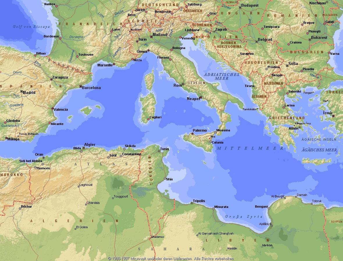
Das Mittelmeer (lateinisch Mare Mediterraneum,[1] deshalb deutsch auch Mittelländisches Meer, präzisierend Europäisches Mittelmeer, im Römischen Reich Mare Nostrum) ist ein Mittelmeer zwischen Europa, Afrika und Asien, ein Nebenmeer des Atlantischen Ozeans und, da es mit der Straße von Gibraltar nur eine sehr schmale Verbindung zum Atlantik besitzt, auch ein Binnenmeer. Im Arabischen und Türkischen wird es auch als „Weißes Meer“ (البحر الأبيض/al-baḥr al-abyaḍ bzw. türk. Akdeniz) bezeichnet.
Zusammen mit den darin liegenden Inseln und den küstennahen Regionen Südeuropas, Vorderasiens und Nordafrikas bildet das Mittelmeer den Mittelmeerraum, der ein eigenes Klima (mediterranes Klima) hat und von einer eigenen Flora und Fauna geprägt ist.
地中海(英文:Mediterranean),被北面的欧洲大陆、南面的非洲大陆以及东面的亚洲大陆包围着。东西长约4000千米,南北最宽处大约为1800千米,面积251.6万平方千米,是地球上最大的陆间海。地中海的平均深度是1500米,最深处为5267米。
地中海西部通过直布罗陀海峡与大西洋相接,东部通过土耳其海峡(达达尼尔海峡和博斯普鲁斯海峡、马尔马拉海)和黑海相连。19世纪时开通的苏伊士运河,接通了地中海与红海。地中海是世界上最古老的海之一[3],而其附属的大西洋却是年轻的海洋。地中海处在欧亚板块和非洲板块交界处,是世界最强地震带之一。地中海地区有维苏威火山、埃特纳火山。
地中海作为陆间海,风浪较小,加之沿岸海岸线曲折、岛屿众多,拥有许多天然良好的港口,成为沟通三个大陆的交通要道。这样的条件,使地中海从古代开始海上贸易就很繁盛,促进了古代古埃及文明、古希腊文明、罗马帝国等的发展。现在也是世界海上交通的重要地区之一。其沿岸的腓尼基人、克里特人、希腊人,以及后来的葡萄牙人和西班牙人都是航海业发达的民族。著名的航海家如哥伦布、达·伽马、麦哲伦等,都出自地中海沿岸的国家。
地中海沿岸夏季炎热干燥,冬季温暖湿润,被称作地中海性气候。植被,叶质坚硬,叶面有蜡质,根系深,有适应夏季干热气候的耐旱特征,属亚热带常绿硬叶林。这里光热充足,是欧洲主要的亚热带水果产区,盛产柑橘、无花果,和葡萄等,还有木本油料作物油橄榄。
地中海(ちちゅうかい、ラテン語: Mare Mediterraneum)は、北と東をユーラシア大陸、南をアフリカ大陸(両者で世界島)に囲まれた地中海盆地に位置する海である。面積は約3000平方キロメートル、平均水深は約1500メートル[2]。海洋学上の地中海の一つ。
地中海には、独立した呼称を持ついくつかの海域が含まれる(エーゲ海、アドリア海など)。地中海と接続する他の海としては、ジブラルタル海峡の西側に大西洋が、ダーダネルス海峡を経た北東にマルマラ海と黒海があり、南西はスエズ運河で紅海と結ばれている(「海域」「地理」で詳述)。
北岸の南ヨーロッパ、東岸の中近東、南岸の北アフリカは古代から往来が盛んで、「地中海世界」と総称されることもある[3]。
The Mediterranean Sea is a sea connected to the Atlantic Ocean, surrounded by the Mediterranean Basin and almost completely enclosed by land: on the north by Southern Europe and Anatolia, on the south by North Africa and on the east by the Levant. Although the sea is sometimes considered a part of the Atlantic Ocean, it is usually identified as a separate body of water. Geological evidence indicates that around 5.9 million years ago, the Mediterranean was cut off from the Atlantic and was partly or completely desiccated over a period of some 600,000 years, the Messinian salinity crisis, before being refilled by the Zanclean flood about 5.3 million years ago.
It covers an approximate area of 2.5 million km2 (965,000 sq mi), but its connection to the Atlantic (the Strait of Gibraltar) is only 14 km (8.7 mi) wide. The Strait of Gibraltar is a narrow strait that connects the Atlantic Ocean to the Mediterranean Sea and separates Gibraltar and Spain in Europe from Morocco in Africa. In oceanography, it is sometimes called the Eurafrican Mediterranean Sea or the European Mediterranean Sea to distinguish it from mediterranean seas elsewhere.[2][3]
The Mediterranean Sea has an average depth of 1,500 m (4,900 ft) and the deepest recorded point is 5,267 m (17,280 ft) in the Calypso Deep in the Ionian Sea. The sea is bordered on the north by Europe, the east by Asia, and in the south by Africa. It is located between latitudes 30° and 46° N and longitudes 6° W and 36° E. Its west-east length, from the Strait of Gibraltar to the Gulf of Iskenderun, on the southwestern coast of Turkey, is approximately 4,000 km (2,500 miles). The sea's average north-south length, from Croatia’s southern shore to Libya, is approximately 800 km (500 miles). The Mediterranean Sea, including the Sea of Marmara (connected by the Dardanelles to the Aegean Sea), has a surface area of approximately 2,510,000 square km (970,000 square miles).[4]
The sea was an important route for merchants and travellers of ancient times that allowed for trade and cultural exchange between emergent peoples of the region. The history of the Mediterranean region is crucial to understanding the origins and development of many modern societies.
The countries surrounding the Mediterranean in clockwise order are Spain, France, Monaco, Italy, Slovenia, Croatia, Bosnia and Herzegovina, Montenegro, Albania, Greece, Turkey, Syria, Lebanon, Israel, Egypt, Libya, Tunisia, Algeria, and Morocco; Malta and Cyprus are island countries in the sea. In addition, the Gaza Strip and the British Overseas Territories of Gibraltar and Akrotiri and Dhekelia have coastlines on the sea.
La mer Méditerranée (prononcé [me.di.tɛ.ʁa.ne]) est une mer intercontinentale presque entièrement fermée, bordée par les côtes d'Europe du sud, d’Afrique du Nord et d’Asie, depuis le détroit de Gibraltar à l'ouest aux entrées des Dardanelles et du canal de Suez à l'est. Elle s’étend sur une superficie d’environ 2,5 millions de kilomètres carrés. Son ouverture vers l’océan Atlantique par le détroit de Gibraltar est large de 14 kilomètres.
Elle doit son nom au fait qu’elle est littéralement une « mer au milieu des terres », en latin « mare medi terra »1.
Durant l’Antiquité, la Méditerranée était une importante voie de transports maritimes permettant l’échange commercial et culturel entre les peuples de la région — les cultures mésopotamiennes, égyptienne, perse, phénicienne, carthaginoise, berbère, grecque, arabe (conquête musulmane), ottomane, byzantine et romaine. L’histoire de la Méditerranée est importante dans l’origine et le développement de la civilisation occidentale.
Il mar Mediterraneo, detto brevemente Mediterraneo, è un mare intercontinentale situato tra Europa, Nordafrica e Asia occidentale connesso all'Oceano Atlantico. La sua superficie approssimativa è di 2,51 milioni di km² e ha uno sviluppo massimo lungo i paralleli di circa 3 700 km. La lunghezza totale delle sue coste è di 46 000 km, la profondità media si aggira sui 1 500 m, mentre quella massima è di 5 270 m presso le coste del Peloponneso. La salinità media si aggira dal 36,2 al 39 ‰.[2] La popolazione presente negli stati bagnati dalle sue acque ammonta a circa 450 milioni di persone.[2].
El mar Mediterráneo es uno de los mares del Atlántico. Está rodeado por la región mediterránea, comprendida entre Europa meridional, Asia Occidental y África septentrional. Fue testigo de la evolución de varias civilizaciones como los egipcios, los fenicios, hebreos, griegos, cartagineses, romanos, etc. Con aproximadamente 2,5 millones de km² y 3.860 km de longitud, es el segundo mar interior más grande del mundo, después del Caribe.1 Sus aguas, que bañan las tres penínsulas del sur de Europa (Ibérica, Itálica, Balcánica) y una de Asia (Anatolia), comunican con el océano Atlántico a través del estrecho de Gibraltar, con el mar Negro por los estrechos del Bósforo y de los Dardanelos y con el mar Rojo por el canal de Suez.2 Es el mar con las tasas más elevadas de hidrocarburos y contaminación del mundo.3
Средизе́мное мо́ре — межматериковое море, по происхождению представляющее собой глубоководную псевдоабиссальную внутришельфовую депрессию[1][2], связанную на западе с Атлантическим океаном Гибралтарским проливом[3].
В Средиземном море выделяют, как его составные части, моря: Адриатическое, Альборан, Балеарское, Ионическое, Кипрское, Критское, Левантийское, Ливийское, Лигурийское, Тирренское и Эгейское. В бассейн Средиземного моря также входят Мраморное, Чёрное и Азовское моря.
 *Mediterranean Sea
 Egypt
Egypt
 Albania
 Algeria
 Amber Road
 Bosnia Herzegovina
 France
 Gibraltar
 Greece
 Israel
 Italy
Italy
 Croatia
 Libanon
 Libya
Libya
 Malta
Malta
 Malta
Malta
 Monaco
 Montenegro
 Palestine
 Slovenia
 Spain
Spain
 Syria
Syria
 Tunisia
 Turkey
 Cyprus


Das Tal der Könige (arabisch وادي الملوك, DMG Wādī al-Mulūk; auch Wadi el-Muluk, Bibân el-Molûk, Biban el-Muluk) – gelegen in der Nähe des altägyptischen Theben, heute etwa 5 km nordwestlich des Zentrums der oberägyptischen Stadt Luxor – war eine Nekropole im Alten Ägypten, in der bis heute 64 Gräber und Gruben aufgefunden wurden. „KV65“ ist eine Radaranomalie, die als Grab gedeutet wird, aber bis heute nicht weiter untersucht wurde. Altägyptisch wurde das Tal der Könige als Sechet-aat (Sḫt ˁ3t), „großes Feld“, bezeichnet.[2]
Im Tal der Könige sind insbesondere die Gräber der Herrscher des Neuen Reichs (ca. 1550 bis 1069 v. Chr.[3], 18. bis 20. Dynastie) zu finden. Das Tal befindet sich in Theben-West, gegenüber von Karnak, am Rand der Wüste und ist gesäumt von hohen Bergen, namentlich von der natürlichen Felspyramide el Korn oder el-Qurn („das Horn“). Nahezu das gesamte Gebiet von Theben-West bildet eine riesige Nekropole. Südlich davon liegt das Tal der Königinnen und dazwischen die Nekropolen Dra Abu el-Naga, el-Chocha, al-Asasif, Deir el-Bahari, Scheich Abd el-Qurna, Qurnet Murrai und Deir el-Medina mit den „Gräbern der Noblen“.
Trotz jahrtausendelanger Aktivität von Grabräubern und Plünderern lieferte das Tal der Könige den Ägyptologen der Neuzeit noch zahlreiche höchst wertvolle Grabungsfunde. Unter anderem wurde hier im Jahr 1922 von Howard Carter das weitgehend unversehrte Grab des Tutanchamun (KV62) entdeckt.
帝王谷(阿拉伯语:وادي الملوك Wādī al Mulūk; 科普特语:ϫⲏⲙⲉ[1];英语:Valley of the Kings)或被称为国王之门谷[2](阿拉伯语:وادي أبواب الملوكWādī Abwāb al-Mulūk')是位于埃及的一个山谷,埋葬古埃及新王国时期18到20王朝的法老和贵族而闻名。[3][4]
帝王谷位于底比斯(现卢克索)对面的尼罗河西岸[5][6] ,位于底比斯墓地的中心地带。干河由两个山谷组成:东谷(大部分皇家陵墓所在的地方)和西谷(猴子谷)。[7][8] 随着2005年发现一个新墓室和2008年发现另外两个墓穴入口,帝王谷已知有63座墓葬和墓室[9](大小从简单的KV54到拥有超过120个房间)[10]。它是埃及新王国主要王室成员以及一些特权贵族的主要墓地。始于图特摩斯一世时期终于拉美西斯十世或十一世时期,皇家陵墓装饰著埃及神话中的场景,并提供有关该时期信仰和丧葬习俗的线索。几乎所有的陵墓似乎都在古代被打开和抢劫过。
自十八世纪末以来,帝王谷地区一直是考古和埃及学探索的重点,其墓葬和规模继续激发着考古学家对此的研究和兴趣。自1920年代以来,该山谷以发现图坦卡蒙之墓而闻名,成为世界上最著名的考古遗址之一。1979年,它与底比斯墓地的其余部分被联合国教科文组织登录为世界文化遗产[11]。当代,山谷继续进行勘探、挖掘和保护,最近开设了一个新的旅游中心。
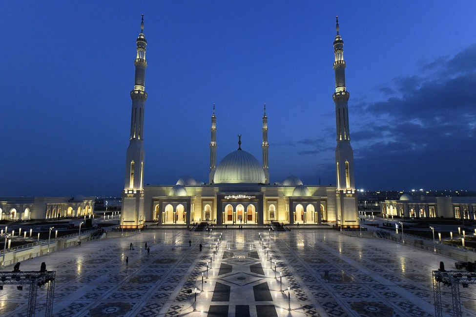
Die al-Fattah-al-Alim-Moschee (arabisch مسجد الفتاح العليم, DMG Masǧid al-Fattāḥ al-ʿAlīm) ist eine Moschee in Ägypten. Sie wurde am 6. Januar 2019 von Abdel Fattah as-Sisi, dem Präsidenten Ägyptens, eingeweiht. Die Moschee hat ein Fassungsvermögen von fast 17.000 Menschen. Die Moschee befindet sich an der Neuen Hauptstadt Ägyptens und gilt als die größte Moschee des Landes und eine der größten Moscheen weltweit.[1]
Mit einer Gesamtfläche von 450.000 m² gilt die Moschee als die zweitgrößte Moschee der Welt. Sie verfügt über einen Landeplatz, Parkplätze für 2650 Autos, Dienstleistungseinrichtungen und ein Verwaltungsgebäude, in dem 60 Mitarbeiter für den Betrieb der Moschee untergebracht sind. Die Moschee verfügt über 21 Kuppeln und vier Minarette, welche eine Höhe von 95 Metern erreichen.[2][1]
Die Bauarbeiten begannen 2017 und dauerten 15 Monate bis Dezember 2018. Das Ingenieurbüro der ägyptischen Streitkräfte bestand darauf, ägyptischen Marmor für den Bau der Moschee zu verwenden und dass nur ägyptische Arbeiter den Bau durchführten. Der ägyptische Präsident Abdel Fattah as-Sisi weihte die Moschee 2019 ein und weihte am selben Tag gleichzeitig auch die Christi-Geburt-Kathedrale ein.
 Egypt
Egypt
 Egypt
Egypt
 Egypt
Egypt
 Egypt
Egypt
 Egypt
Egypt
 Egypt
Egypt
 Egypt
Egypt
 Algeria
 Ethiopia
 Côte d´Ivoire
 Côte d´Ivoire
 Demokratische Republik Kongo
 Demokratische Republik Kongo
 Ghana
Ghana
 Ghana
Ghana
 Ghana
Ghana
 Ghana
Ghana
 Cameroon
 Cameroon
 Cameroon
 Cameroon
 Cameroon
 Morocco
 Nigeria
 Nigeria
 Nigeria
 Republik Kongo
 Republic of the Sudan
 Sambia
 South Africa
 Tunisia
 Egypt
Egypt
 Algeria
 Angola
 Equatorial Guinea
 Ethiopia
 Botsuana
 Burkina Faso
 Côte d´Ivoire
 Eritrea
 Ghana
Ghana
 Cameroon
 Kenya
Kenya
 Libya
Libya

 Aerospace
 Madagaskar
 Malawi
 Mali
Mali
 Morocco
 Mauritius
 Mosambik
 Namibia
 Republik Kongo
 Republic of the Sudan
 Ruanda
 Seychellen
 Simbabwe
 South Africa
 Tansania
 Tschad
 Tunisia

 African Union
 Alpha Condé
 African Union
 Bingu wa Mutharika
 African Union
 Denis Sassou Nguesso
 African Union
 Hailemariam Desalegn
 African Union
 Idriss Déby
 African Union
 Jakaya Kikwete
 African Union
 Joaquim Chissano
 African Union
 John Agyekum Kufuor
 African Union
 Mohamed Ould Abdel Aziz
 African Union
 Muammar al-Gaddafi
 African Union
 Olusegun Obasanjo
 African Union
 Robert Mugabe
 African Union
 Teodoro Obiang Nguema Mbasogo
 African Union
 Thabo Mbeki
 African Union
 Thomas Boni Yayi
 African Union
 Paul Kagame
 African Union
 Abd al-Fattah as-Sisi
 African Union
 Moussa Faki
 African Union
 Nkosazana Dlamini-Zuma
 African Union
 Jean Ping
 African Union
 Alpha Oumar Konaré
 African Union
 Amara Essy
 African Union
 Mohamed Ould Ghazouani
 African Union
 Azali Assoumani
 African Union
 Macky Sall
 African Union
 Félix Tshisekedi
 Egypt
Egypt
 Algeria
 Angola
 Equatorial Guinea
 Ethiopia
 Benin
Benin
 Botsuana
 Burkina Faso
 Burundi
 Côte d´Ivoire
 Demokratische Arabische Republik Sahara
 Demokratische Republik Kongo
 Djibouti
 Eritrea
 Gabun
Gabun
 Gambia

 Geography
 Ghana
Ghana
 Guinea
 Guinea-Bissau
 Cameroon
 Kap Verde
 Kenya
Kenya
 Comoros
 Lesotho
 Liberia
 Libya
Libya
 Madagaskar
 Malawi
 Mali
Mali
 Morocco
 Mauritania
 Mauritius
 Mosambik
 Namibia
 Niger
Niger
 Nigeria

 Party and government

 Party and government
 Group of the twenty most important industrial and emerging countries
 Republik Kongo
 Republic of the Sudan
 Republik Südsudan
 Ruanda
 Sambia
 Sao Tome und Principe
 Senegal
 Seychellen
 Sierra Leone
 Simbabwe
 South Africa
 Swasiland
 Tansania
 Togo
Togo
 Tschad
 Tunisia
 Uganda

 Important International Organizations

 Economy and trade
 Central African Republic

Die Afrikanische Union (arabisch الاتحاد الأفريقي, DMG al-Ittiḥād al-Ifrīqī, englisch African Union, französisch Union africaine, portugiesisch União Africana)[2] ist eine Internationale Organisation, die 2002 die Nachfolge der Organisation für Afrikanische Einheit (OAU) angetreten hat und sich für Kooperation auf allen Gebieten einsetzen soll. Sie ist ein Zusammenschluss von anfangs 53 afrikanischen Staaten (Westsahara ist Mitglied der Afrikanischen Union, sein völkerrechtlicher Status allerdings umstritten).
Der Hauptsitz der Organisation befindet sich im äthiopischen Addis Abeba, das Panafrikanische Parlament im südafrikanischen Midrand. Mitgliedstaaten der AU sind alle international allgemein anerkannten afrikanischen Staaten, einschließlich Westsaharas. Geplant ist in der AU unter anderem ein Afrikanischer Gerichtshof. Marokko wurde am 30. Januar 2017 nach 33 Jahren Abwesenheit wieder in die Afrikanische Staatengemeinschaft aufgenommen.[3]
非洲联盟(法语:Union Africaine; 英语:African Union),简称非盟(UA或AU),是一个包涵了55个非洲国家的联盟,是属于集政治、经济和军事于一体的全非洲性政治实体。非洲联盟于未来有计划统一使用货币、联合防御力量、以及成立跨国家的机关,这包括一个管理非洲联盟的内阁政府。此联盟的主要目的是帮助发展及稳固非洲的民主、人权、以及能永续发展的经济,除此之外亦希望减少非洲内部的武装战乱及创造一个有效的共同市场,最终目标是建立“非洲合众国”。
前身是1963年在埃塞俄比亚首都亚的斯亚贝巴成立的“非洲统一组织”。2002年7月在南非改组。[6]2017年在第28届非盟首脑会议上,摩洛哥获得了54个成员国中的42国同意,时隔33年重新成为该组织成员国,至此非洲联盟已涵盖所有非洲主权国家。[7]
アフリカ連合(アフリカれんごう)は、アフリカの国家統合体。アフリカ統一機構 (OAU) が、2002年に発展改組して発足した[3]。エチオピアのアディスアベバに本部を置いている。
1963年に創設されたアフリカ統一機構は、モロッコを除くアフリカ大陸の53か国(当時)全てが加入する世界最大の地域統合であったが、「統一機構」という名とは裏腹に各国間の内政不干渉を原則としており、各国で頻発する内戦やクーデターといった危機に対して有効な手段をとることができておらず、機能不全に陥っていた[4]。また、各国間の経済統合なども遅々として進んでいなかった。こうした状況に一石を投じたのが、1991年に締結されたアブジャ条約である。この条約では、アフリカ各国は2028年までに大陸統一通貨「アフロ」を導入し、アフリカ経済共同体(AEC)を創設することが謳われた。これによりアフリカ大陸が経済統合の方向に向かう中、より一層のアフリカ大陸の統合を進めるために新しい機構の創設が求められるようになった。
こうしたなか、アフリカ統一機構により強い権限を持たせ、政治・経済的統合を進めて最終的に欧州連合的な形態にアフリカ大陸を持っていくことを目的として、旧統一機構をアフリカ連合へと改組することを提案したのが、リビアの元首だったムアンマル・アル=カッザーフィーであった。カッザーフィーは1997年以降急速にアラブからアフリカへと外交重心を転換させていたが、1999年9月のスルトにおけるOAU首脳会談においてAUへの移行がリビアによって正式提案された[5]。この提案は各国に受け入れられ、アフリカ統一機構からアフリカ連合への移行のため、2000年7月のロメOAU首脳会議でアフリカ連合制定法(アフリカ連合を創設するための条約)が採択され、各国の批准を待って、2001年に発効した[6]。2002年7月のダーバン首脳会議を経て、アフリカ連合は正式に発足した。
アフリカ連合は、アフリカの一層高度な政治的経済的統合の実現及び紛争の予防解決への取組強化のため発足した地域統合体である。アフリカ諸国と諸国民間の一層の統一性及び連帯性の強化、アフリカの政治的経済的社会的統合の加速化、アフリカの平和と域内紛争や独裁政治の根絶、安全保障及び安定の促進、民主主義原則と国民参加統治の促進、持続可能な開発の促進、教育及び科学等での協力、グローバリゼーション時代におけるアフリカ諸国の国際的な地位向上、等を目指している。また、欧州連合(EU)をモデルとした地域統合を目標に掲げており、将来的には統一した国家へ発展させ、アフリカ合衆国を創ることも視野に入れている。
2001年にはアフリカ開発のための新パートナーシップ(NEPAD)を採択し、アフリカ大陸の開発のための指針を表明した。また、これに基づいて、各国が加盟国のガバナンスなどの状況を審査するアフリカン・ピア・レビュー・メカニズム(アフリカにおける相互審査システム、APRM)が創設され、2005年にはガーナの、2006年にはルワンダの報告書が作成された[7]。
The African Union (AU) is a continental union consisting of 55 member states located on the continent of Africa, with exception of various territories of European possessions located in Africa. The bloc was founded on 26 May 2001 in Addis Ababa, Ethiopia and launched on 9 July 2002 in South Africa.[6] The intention of the AU is to replace the Organisation of African Unity (OAU), established on 25 May 1963 in Addis Ababa by 32 signatory governments. The most important decisions of the AU are made by the Assembly of the African Union, a semi-annual meeting of the heads of state and government of its member states. The AU's secretariat, the African Union Commission, is based in Addis Ababa.
In result of its geographical location, the African Union has an area of around 29 million km2 (11 million sq mi) and includes popular world landmarks, including the Sahara and the Nile.[7] They have adopted a gold, green and red based emblem and flag to represent the continental union, where they held a competition for citizens to design a flag in which they chose a submission to replace the old flag. Their main celebration occurs on Africa Day on 25 May. The primary languages spoken include Arabic, English, French and Portuguese and the languages of Africa. Within the African Union, there are official bodies such as the Peace and Security Council and the Pan-African Parliament.
L'Union africaine (UA) est une organisation d'États africains créée en 2002, à Durban en Afrique du Sud, en application de la déclaration de Syrte du 9 septembre 1999. Elle a remplacé l'Organisation de l'unité africaine2 (OUA). La mise en place de ses institutions (Commission, Parlement panafricain et Conseil de paix et de sécurité) a eu lieu en juillet 2003 au sommet de Maputo au Mozambique.
Son premier président a été le Sud-Africain Thabo Mbeki, précédemment président de l'OUA.
Ses buts sont d'œuvrer à la promotion de la démocratie, des droits de l'Homme et du développement à travers l'Afrique, surtout par l'augmentation des investissements extérieurs par l'intermédiaire du programme du Nouveau partenariat pour le développement de l'Afrique (NEPAD). Ce programme considère que la paix et la démocratie sont des préalables indispensables au développement durable.
Les objectifs de l'UA comportent la création d'une banque centrale de développement.
L'Unione africana (UA) è un'organizzazione internazionale comprendente tutti gli Stati africani, con sede ad Addis Abeba, in Etiopia. Les objectifs de l'UA comportent la création d'une banque centrale de développement.
Si tratta di un'organizzazione internazionale molto giovane, nata ufficialmente con il primo vertice dei capi di Stato e di governo del 9 luglio 2002 a Durban, in Sudafrica, durante il quale ne assunse la presidenza Thabo Mbeki, presidente sudafricano. Nel corso del vertice, al quale presenziava tra gli altri il segretario generale delle Nazioni Unite Kofi Annan, furono sottoscritti i primi atti riguardanti gli organi dell'Unione, ovvero il protocollo relativo allo stabilimento del Consiglio di pace e sicurezza e lo statuto della commissione, e furono stabilite regole e procedure per l'Assemblea, il consiglio esecutivo e il comitato dei rappresentanti permanenti.
Le fasi del processo di sviluppo precedenti al vertice di Durban avvennero all'interno dell'Organizzazione dell'unità africana. Nella sessione straordinaria del 1999 a Sirte, in Libia, (luogo di nascita del Leader libico Mu'ammar Gheddafi promotore dell'organizzazione, anche con cospicui capitali) l'Organizzazione decise la nascita della nuova Unione.
Il Sahara Occidentale è ammesso come Repubblica democratica araba Sahrawi, pur non essendo a tutti gli effetti indipendente trattandosi di un territorio conteso con il Marocco.
Nel 2000 fu adottato l'atto costitutivo, che entrò in vigore il 26 maggio 2001, un mese esatto dopo la sottoscrizione della Nigeria, il trentaseiesimo Stato ad averlo ratificato. Come previsto dall'atto per un anno vi fu coesistenza tra le due organizzazioni.
Il 15 agosto 2002 le è stato riconosciuto lo status di osservatore dell'Assemblea generale delle Nazioni Unite.
La Unión Africana (por su acrónimo UA, o AU en inglés u otras de sus lenguas oficiales) es una unión política formada por 55 Estados africanos. La UA se creó el 26 de mayo de 2001 en Adís Abeba y comenzó a funcionar el 9 de julio de 2002 en Durban (Sudáfrica),2 reemplazando a la Organización para la Unidad Africana (OUA). Las decisiones más importantes de la UA son tomadas por la Asamblea de la Unión Africana, una reunión semestral de jefes de Estado y de gobierno de sus Estados miembros. El secretariado de la UA, la Comisión de la Unión Africana, tiene su sede en Adís Abeba, capital de Etiopía.
Африка́нский сою́з (сокращённо АС, АфроСоюз) — международная межправительственная организация, объединяющая 55 государств Африки, правопреемник Организации африканского единства (ОАЕ). Основана 9 июля 2002 года[4]. Важнейшие решения в рамках организации принимаются на Ассамблее Африканского союза — собрании глав государств и правительств государств — членов организации, которое проводится раз в полгода. Секретариат Африканского союза и Комиссия Африканского союза расположены в Аддис-Абебе, столице Эфиопии. В феврале 2009 года было принято решение о преобразовании Комиссии Африканского союза в Полномочный орган Африканского союза (англ. African Union Authority)[5].
 Egypt
Egypt
 Algeria
 Ethiopia
 Benin
Benin
 Burkina Faso
 Djibouti
 Eritrea
 Gambia
 Ghana
Ghana
 Cameroon
 Kap Verde

 Agriculture, forestry, livestock, fishing
 Libya
Libya
 Mali
Mali
 Mauritania
 Niger
Niger
 Nigeria
 Republic of the Sudan
 Senegal
 Somalia
 Tschad
 Tunisia
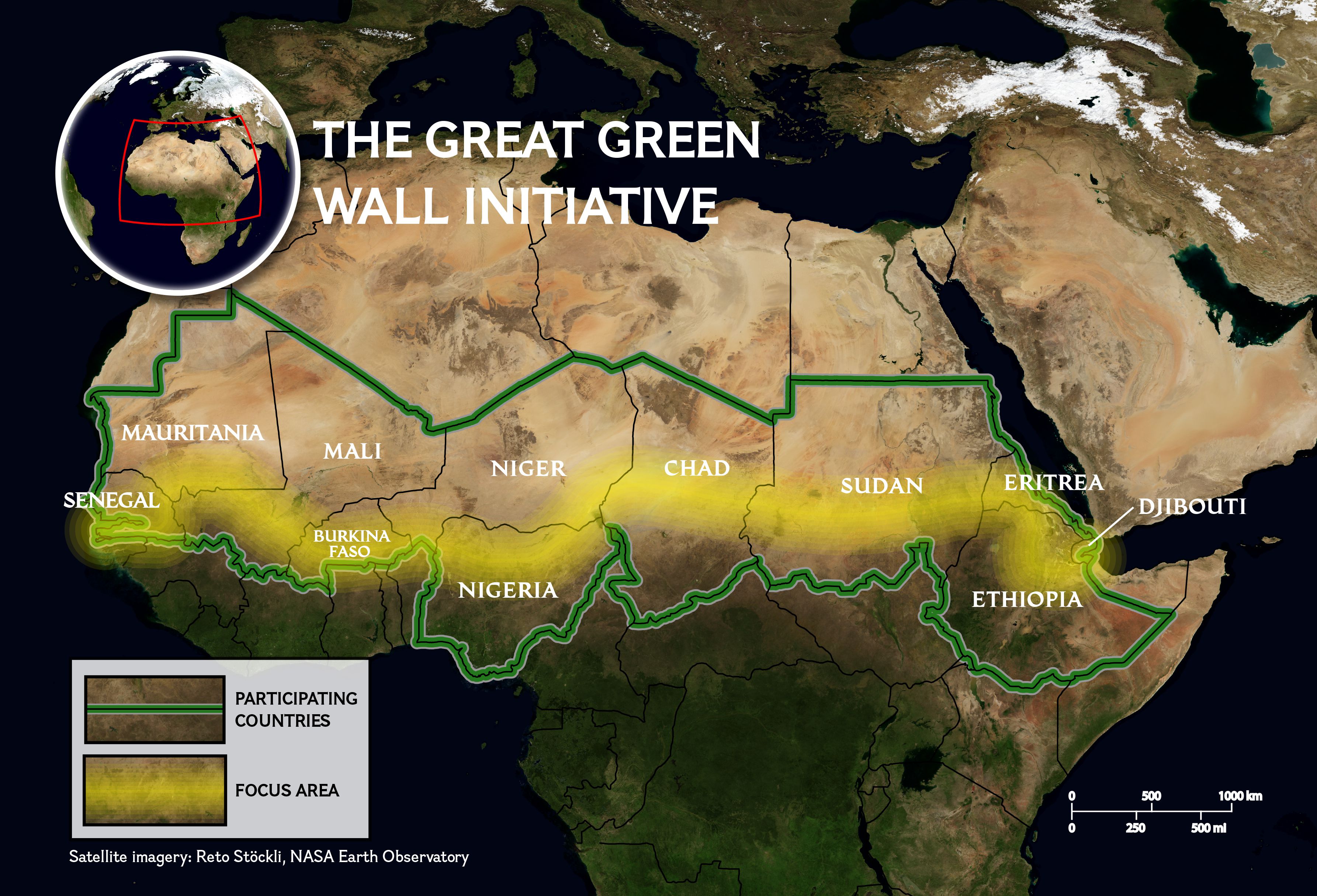
Afrikas Grüne Mauer (englisch Great Green Wall) oder auch Initiative Große Grüne Mauer der Sahara und des Sahel (kurz GGWSSI; englisch Great Green Wall of the Sahara and the Sahel Initiative) genannt, ist Afrikas Vorzeigeinitiative, um die Effekte des Klimawandels und der Desertifikation zu bekämpfen. Die Initiative wird von der Afrikanischen Union geführt. Das Ziel ist die Erschaffung eines großen Mosaiks aus grüner und produktiver Landschaft, das sich über Nordafrika, die Sahelzone und das Horn von Afrika erstreckt. Mittel dazu sind u. a. Aufforstungsprojekte und die Wiederherstellung degradierter Böden. Grund ist die Verhinderung weiterer Desertifikation in der Sahelzone.
非洲绿色长城(英语:Great Green Wall)为沿着撒哈拉沙漠南缘的萨赫尔地区种植跨越非洲大陆的树墙,是一项防止沙漠化的计划。这项计划由非洲联盟主导,概念起自于绿色前线、中国的三北防护林等大型绿色工程计划,以解决撒赫尔和撒哈拉地区在土地退化和沙漠化后所导致的社会、经济、环境的不利影响。
 Egypt
Egypt
 Algeria

 Eat and Drink
 *Olives/Olive oil
 Greece
 Italy
Italy

 Agriculture, forestry, livestock, fishing
 Morocco
 Portugal
 Spain
Spain
 Syria
Syria
 Tunisia
 Turkey
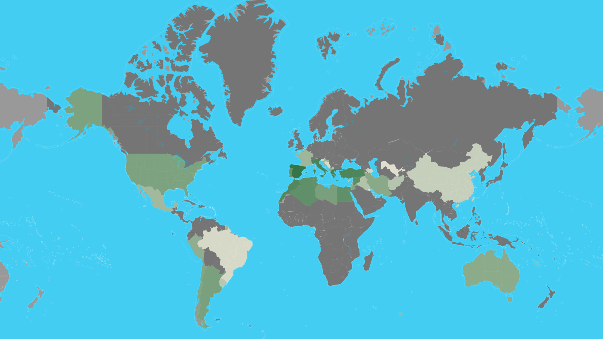
| Rank | Country | Production (Tonnes) | Production per Capita (Kg) | Harvasted Area (Ha) | Yield (Kg/Ha) |
|---|---|---|---|---|---|
| 1 | Spain | 6,559,884 | 141 | 2,573,473 | 2,549 |
| 2 | Greece | 2,343,383 | 218 | 887,177 | 2,641 |
| 3 | Italy | 2,092,175 | 34.6 | 1,165,562 | 1,795 |
| 4 | Turkey | 1,730,000 | 21.4 | 845,542 | 2,046 |
| 5 | Morocco | 1,416,107 | 40.7 | 1,008,365 | 1,404 |
| 6 | Syria | 899,435 | 49.2 | 765,603 | 1,175 |
| 7 | Tunisia | 700,000 | 61.2 | 1,646,060 | 425 |
| 8 | Algeria | 696,962 | 16.4 | 424,028 | 1,644 |
| 9 | Egypt | 694,309 | 7.1 | 67,293 | 10,318 |
| 10 | Portugal | 617,610 | 60.0 | 355,075 | 1,739 |
| 11 | Libya | 188,975 | 29.2 | 357,797 | 528 |
| 12 | Argentina | 175,094 | 3.9 | 61,942 | 2,827 |
| 13 | United States of America | 159,600 | 0.49 | 14,164 | 11,268 |
| 14 | Lebanon | 118,146 | 19.4 | 62,297 | 1,897 |
| 15 | Jordan | 115,813 | 11.3 | 63,963 | 1,811 |
| 16 | Chile | 111,481 | 6.3 | 20,343 | 5,480 |
| 17 | Albania | 99,075 | 34.5 | 38,889 | 2,548 |
| 18 | Palestinian Territories | 95,044 | | 66,645 | 1,426 |
| 19 | Israel | 91,000 | 10.2 | 33,700 | 2,700 |
| 20 | Iran | 85,049 | 1.0 | 66,915 | 1,271 |
| 21 | Australia | 75,083 | 3.0 | 32,747 | 2,293 |
| 22 | Peru | 56,157 | 1.8 | 17,119 | 3,281 |
| 23 | Croatia | 31,183 | 7.4 | 18,184 | 1,715 |
| 24 | France | 27,102 | 0.40 | 17,354 | 1,562 |
| 25 | Mexico | 21,650 | 0.17 | 5,094 | 4,250 |
| 26 | Cyprus | 13,499 | 15.8 | 10,612 | 1,272 |
| 27 | Macedonia | 12,369 | 6.0 | 5,852 | 2,114 |
| 28 | El Salvador | 10,840 | 1.6 | 5,227 | 2,074 |
| 29 | Iraq | 9,332 | 0.24 | 2,294 | 4,068 |
| 30 | Afghanistan | 7,647 | 0.24 | 2,200 | 3,476 |
| 31 | Uruguay | 6,159 | 1.8 | 2,985 | 2,063 |
| 32 | Taiwan | 2,621 | 0.11 | 318 | 8,256 |
| 33 | China | 2,621 | 0.00188 | 318 | 8,256 |
| 34 | Slovenia | 1,662 | 0.80 | 1,173 | 1,417 |
| 35 | Azerbaijan | 1,586 | 0.16 | 2,979 | 533 |
| 36 | Brazil | 647 | 0.00309 | 574 | 1,127 |
| 37 | Bosnia and Herzegovina | 359 | 0.095 | 254 | 1,416 |
| 38 | Montenegro | 250 | 0.40 | 90.0 | 2,778 |
| 39 | Uzbekistan | 116 | 0.00355 | 117 | 987 |
| 40 | Kuwait | 60.0 | 0.014 | 35.0 | 1,702 |
| 41 | Malta | 30.0 | 0.063 | 28.0 | 1,064 |
 Architecture
 Museum
 History
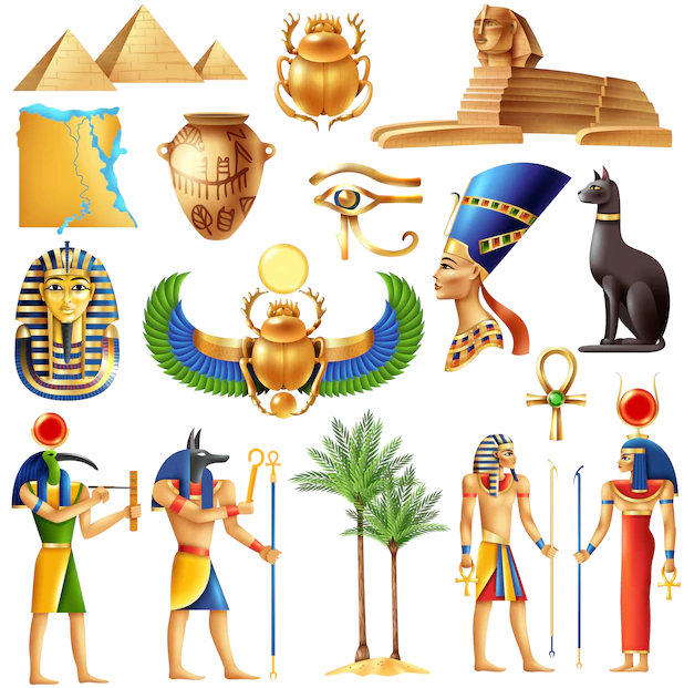 Ancient Egypt
 World Heritage
 Civilization
 Religion
 Sport
Sport
 Transport and traffic
 European Union
 Hand in Hand