
漢德百科全書 | 汉德百科全书
 Chūbu
Chūbu
 Geography
 World Heritage


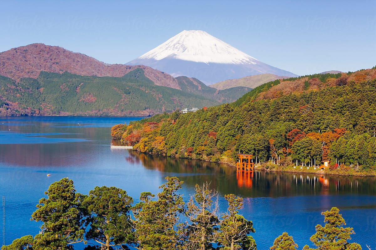
Der Fuji (japanisch ![]() 富士山?/i Fuji-san [ɸɯ(d)ʑisaɴ];[2][3] eingedeutscht: Fudschi; Duden: Fudschijama;[4] übernommen aus dem Englischen: Fujiyama[5]) ist ein Vulkan und mit 3776,24 m[6] Höhe über dem Meeresspiegel der höchste Berg Japans. Sein Gipfel befindet sich auf der japanischen Hauptinsel Honshū an der Grenze zwischen den Präfekturen Yamanashi und Shizuoka. Seit 2013 ist er Teil des Weltkulturerbes.
富士山?/i Fuji-san [ɸɯ(d)ʑisaɴ];[2][3] eingedeutscht: Fudschi; Duden: Fudschijama;[4] übernommen aus dem Englischen: Fujiyama[5]) ist ein Vulkan und mit 3776,24 m[6] Höhe über dem Meeresspiegel der höchste Berg Japans. Sein Gipfel befindet sich auf der japanischen Hauptinsel Honshū an der Grenze zwischen den Präfekturen Yamanashi und Shizuoka. Seit 2013 ist er Teil des Weltkulturerbes.
富士山(日语:![]() 富士山/ふじさん Fujisan)是日本一座横跨静冈县和山梨县的活火山,位于东京西南方约80千米处,主峰海拔3776米,2002年8月(平成14年),经日本国土地理院重新测量后,为3775.63米[3],是日本国内的最高峰[4]。
富士山/ふじさん Fujisan)是日本一座横跨静冈县和山梨县的活火山,位于东京西南方约80千米处,主峰海拔3776米,2002年8月(平成14年),经日本国土地理院重新测量后,为3775.63米[3],是日本国内的最高峰[4]。
富士山顶冬季积雪,直至次年6、7月才会融化,在管理上属于本州地区的富士箱根伊豆国立公园范围内。在富士山山麓周围,分布着5个淡水湖,统称富士五湖,是日本著名的观光度假名胜地。富士山有4个主要的登山口,分别为富士宫口、须走口、御殿场口、富士吉田(河口湖)口等,其中前三个登山入口都在静冈县内。
富士山不但名列日本百名山,同时也是日本三名山之一,在古代文献中亦被称为不二、不尽或是富慈,也经常被称作芙蓉峰、富岳或富岳。自古以来,这座山的名字就经常在日本的传统诗歌和歌中出现。富士山与樱花、新干线并列为日本的国家象征。富士山于2013年6月22日正式获选列入世界文化遗产,是日本的第17个世界遗产(第13个世界文化遗产)。“乡土富士”即遍布日本全国各地带有“富士”名称的山。
 Animal world
 Music
Music
 Performing Arts

 Architecture
 History

冈崎城(おかざきじょう Okazaki-jō)是位于日本爱知县冈崎市的一座城堡。德川家康于此地出生。别名为龙城。
建于1452年,战国时代到安土桃山时代为松平氏所有,江户时代是冈崎藩藩厅所在地。
最初城名写作“冈奇城”(日语:岡竒城)。此外,冈崎城是享禄年间以来的名称,在此之前名为菅生乡[1]。
Die Burg Okazaki (jap. 岡崎城) ist eine japanische Burg in Okazaki (Präfektur Aichi). Sie wurde auch „Drachenburg“ (龍城, Tatsuki) genannt. Zuletzt residierte dort ein Zweig der Honda, die zu den kleineren Fudai-Daimyō gehörten.


每年5月上旬举办为期2天的潮干祭。此祭典与过去祭祀之神神武天皇东征时,从海上经由此地上岸的传说有关,因5辆山车被拽入海滨而得名。退潮后的海滨排列着的5辆山车雄壮华丽,如同盛开在海滩上的花。
祭典的起源没有定论,有一说法是由应仁、文明时代(15世纪后半叶)迁居龟崎的18个武士家族发起的活动,他们在像大蓬车一样的车上插竹子,挂上印染有神纹的帷幕,和着伴奏在城内拉着山车到处游走,据说这就是潮干祭的起源。但是近年来根据专家的调查,有各种史料证明,潮干祭的历史可追溯到元禄至宝历年间(17世纪末至18世纪前半叶左右),此后历经300年岁月直到现在,祭典的风格和传统被很好地保留了下来。
The Shiohi-matsuri Festival is held for two days in early May every year. This festival was named after the legend of Emperor Jimmu’s arrival on this land from the sea during his eastern expedition, and started with the drawing of five parade floats to the beach to pay respects to Emperor Jimmu as the deity of the festival. The five parade floats lined up on the beach at ebb tide are brave and splendid, and they look as if flowers were in bloom on the beach.
The origin of this festival is not certain. There is a legend that 18 samurai families who moved to the land of Kamezaki started the festival during the Japanese eras of Onin and Bummei (late in the 15th century) and that they set up small bamboos like a cart, put a curtain stained with a shrine emblem on it, and towed it in town with a musical accompaniment. Experts tracked back the history of the festival to the Japanese eras of Genroku through Horeki (from the end of the 17th century to the early 18th century) with various historical materials in their recent survey. Since then, it has become evident that the style and tradition of the festival have been inherited firmly for over 300 years.
Top Global University Project
 Global Traction Type
Top Global University Project
Private universities
Universities in Japan
Global Traction Type
Top Global University Project
Private universities
Universities in Japan

 Musical instrument
 Life and Style

 Companies


Die Kurobe-Schlucht (japanisch: 黒部峡谷/くろべきょうこく kurobe kyōkoku) ist eine Schlucht (V-förmiges Tal) am mittleren bis oberen Lauf des Kurobe-Flusses in der Stadt Kurobe, Präfektur Toyama, Japan. Sie trennt den nördlichen Teil der Hida-Bergkette in den Tateyama Lianfeng und den Goto Tateyama Lianfeng. Er wurde als nationales besonderes Naturdenkmal (Naturschutzgebiet) und als besonderer Ort von Interesse ausgewiesen. Er befindet sich im Chubu-Sangaku-Nationalpark. Zusammen mit dem Kiyotsukei-Tal und dem Osugi-Tal gehört es zu den drei besten Tälern Japans und zu den 100 geheimen Orten Japans.
黑部峡谷由蜿蜒穿流在立山、剑岳、药师岳等立山山脉和以白马岳为代表的后立山山脉之间的黑部川形成。在这个由海拔落差3000米的急流侵蚀而成的V字形山谷,碧绿的河水和苍翠的群山,交织成一幅壮丽的美景,它与新潟县的清津峡和三重县的大杉谷并称为日本三大溪谷。


 Automobile

 IT-Times
 Science and technology
 Top Global University Project
National universities
Top Global University Project
Global Traction Type
Universities in Japan
Top Global University Project
National universities
Top Global University Project
Global Traction Type
Universities in Japan
