
漢德百科全書 | 汉德百科全书
 Civilization

 Architecture
 World Heritage

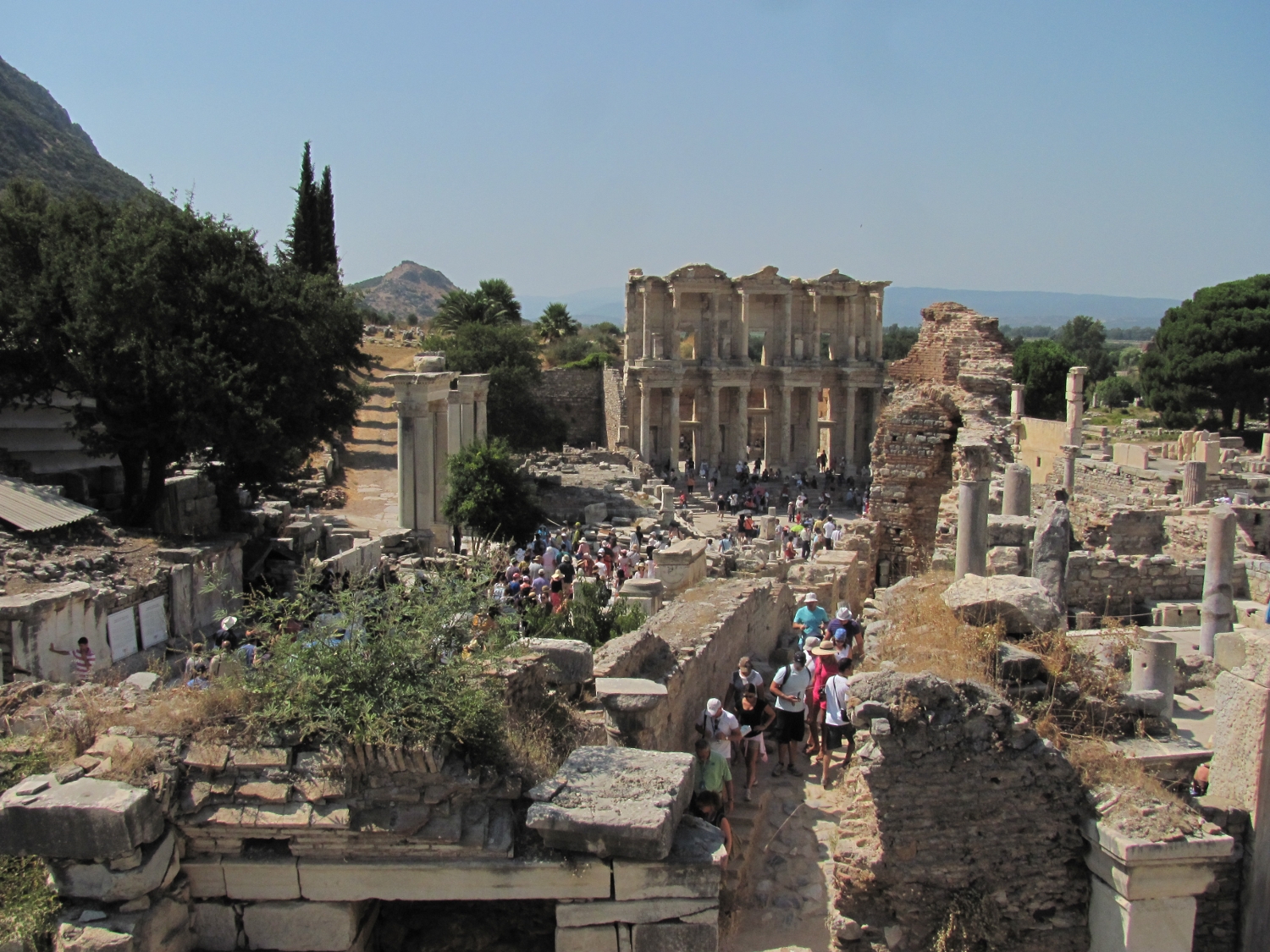
Der Tempel der Artemis in Ephesos oder kurz das Artemision von Ephesos war der Göttin Artemis Ephesia, einer Sonderform der griechischen Göttin Artemis, gewidmet. Er soll von den mythischen Amazonen[1] bzw. ihrer Königin Otrere[2] gegründet worden sein und gehörte als größter Tempelbau zu den „Sieben Weltwundern“ der Antike. Die antike griechische Stadt Ephesos beim heutigen Selçuk an der Südwestküste der heutigen Türkei war für ihren Reichtum berühmt und später als Hauptstadt der römischen Provinz Asia eine der größten Städte der Antike.
Auf Altgriechisch hieß der Tempel ὁ ναὸς τῆς Ἀρτέμιδος Ἐφεσίης (ho naòs tês Artémidos Ephesíês), ὁ ἐν Ἐφέσῳ ναὸς τῆς Ἀρτέμιδος (ho en Ephésô naòs tês Artémidos) oder τὸ Ἀρτεμίσιον Ἐφέσιον (tò Artemísion Ephésion), auf Lateinisch Artemisium Ephesi(n)um oder templum Dianae Ephesi(n)ae.
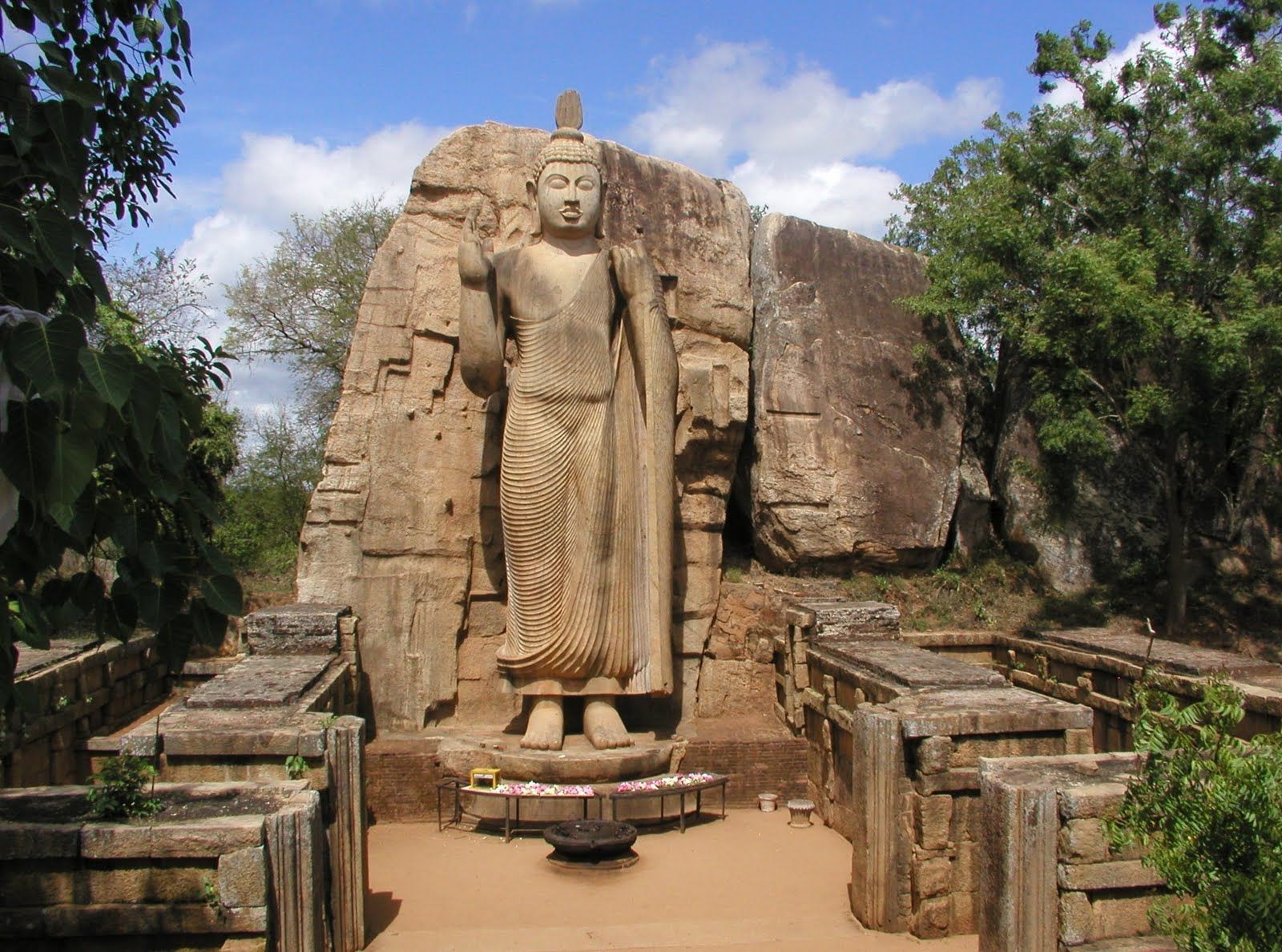
阿尔忒弥斯神庙(希腊语:Ναός της Αρτέμιδος στην Έφεσο)是希腊神话中女神阿提蜜丝的神殿(《圣经》翻作亚底米,即罗马神话的月亮女神狄安娜,故也有资料称之为狄安娜神庙),是古代世界七大奇迹之一。神庙位于希腊人在小亚细亚建立的城镇以弗所(今土耳其塞尔丘克附近)。公元前7世纪,原地旧有的建筑毁于洪水[1]。大约于公元前550年由吕底亚王国的克罗索斯发动重建,大约一百余年后在波斯的阿契美尼德帝国时完成。
公元前356年7月21日,神殿被希腊人黑若斯达特斯纵火焚毁。传说亚历山大大帝诞生于神殿被毁的同一天。公元前323年,神殿开始重建,规模超过以前,长425英尺长,宽230英尺,有126根高60英尺的大理石柱。重建后的神殿矗立了大约六百年。公元246年,神殿被哥特人损坏,之后是否曾重建或重修尚不清楚。1869年考古学家约翰·特陶·伍德发现了阿提蜜丝神殿遗址,发掘工作一直持续到1874年[2]。今日的阿提蜜丝神殿旧址处,人们用发掘出的大理石拼成了一根石柱作为标记。
 Performing Arts
 History
 J 0 - 500 AD
 Music
Music Hall, State Theater, Opera House
Turkey
Civilization
Music
Music Hall, State Theater, Opera House
Turkey
Civilization
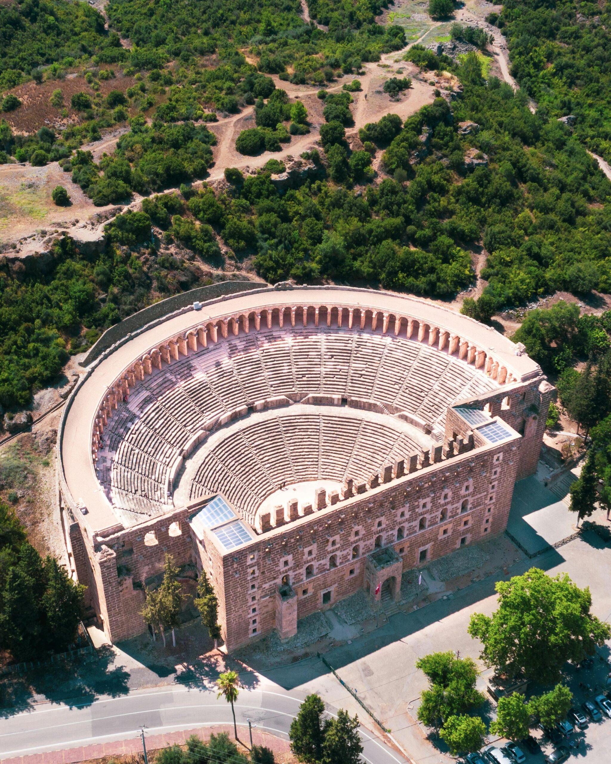
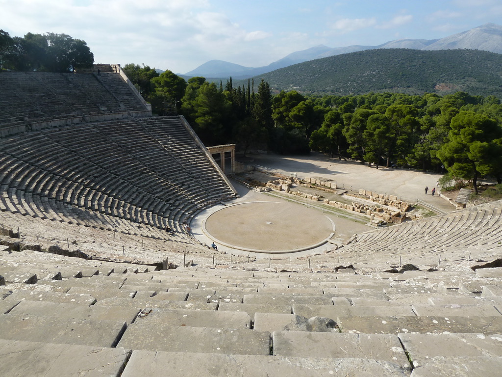
Aspendos (altgriechisch Ἄσπενδος) war eine antike Stadt in Pamphylien in Kleinasien an der Südküste der jetzigen Türkei, in der Nähe des Dorfes Büyükbelkiz, etwa 5 km östlich von Serik. Das große Theater aus römischer Zeit ist eines der besterhaltenen der Antike. Es wird auch heute noch für Aufführungen genutzt.[1] Die Stadt Aspendos ist nicht ausgegraben. Alle aufragenden Gebäude stammen aus der römischen Blütezeit des 2. und 3. Jahrhunderts n. Chr., als Aspendos ein bedeutendes pamphylisches Handelszentrum war. Die Örtlichkeit liegt 46 Kilometer östlich von Antalya an der Straße nach Alanya.
阿斯潘多斯剧场(古希腊语 Ἄσπενδος)是小亚细亚潘菲利亚的一座古城,位于现在的土耳其南部海岸,靠近比尤克贝尔基兹村,在塞里克以东约 5 公里处。罗马时代的大剧院是古代保存最完好的剧院之一。阿斯本多斯城尚未发掘。所有高耸的建筑都是公元 2 世纪和 3 世纪罗马全盛时期的产物,当时阿斯本多斯是重要的潘菲利亚贸易中心。该遗址位于安塔利亚以东 46 公里处通往阿兰亚的公路上。
 Religion

Die Höhlen liegen in einem Talkessel etwa 4 km (Luftlinie) westlich der Kleinstadt Ajanta (Marathi अजिंठा, Ajiṇṭhā) im Norden des indischen Bundesstaates Maharashtra. Die nächste Stadt mit einer Bahnstation, Jalgaon, ist rund 77 km entfernt, doch meist werden die Höhlen im Rahmen einer Tagestour zusammen mit denen von Ellora von der knapp 100 km südlich gelegenen Stadt Aurangabad angefahren. Von dort verkehren auch öffentliche Busse und Taxis.
In einem steil durch den – nur in und nach der Monsunzeit wasserführenden – Fluss Waghora in den Fels eingeschnittenen, U-förmigen Tal findet man zahlreiche in den Fels getriebene, große Höhlentempel.
Vom 2. Jahrhundert vor bis zum Ende des 7. Jahrhunderts nach der Zeitenwende war das Tal von buddhistischen Mönchen bewohnt. Während der Vakataka-Dynastie im 5. Jahrhundert wurden die meisten Höhlen gebaut, wenngleich die Vertreter des Vakataka als Anhänger des Brahmanismus selbst nicht Hand anlegten. Die Baumeister waren anfänglich die Mönche selbst; später wurden die einfachen, vielleicht aber auch Teile der komplizierteren Arbeiten von geschulten und bezahlten Steinmetzen erledigt. Nach offizieller Zählung des Archaeological Survey of India wurden 29 große Höhlen in den Fels getrieben; diese waren bis zu 30 m breit und tief (Höhle 4) und ca. 4 bis 8 m hoch. Aus verschiedenen Gründen (schmucklose Stützen und Architrav, anikonischer Stupa) kann man davon ausgehen, dass die Höhle 10 die älteste aller Höhlen von Ajanta ist und im 2. Jahrhundert v. Chr. geschaffen wurde. Die Bauphasen und Meißelzeiten schwanken je nach Größe und Dekor pro Höhle zwischen 1 und 5 Jahren. Im 7./8. Jahrhundert erreichte eine Welle der Feindlichkeiten gegen Buddhisten in ganz Indien auch dieses abgeschiedene Tal. Die Mönche wurden vertrieben; die Höhlen gerieten in Vergessenheit und wurden im Laufe der Zeit vom Verwitterungsschutt der darüberliegenden Felswände verdeckt.
Im April 1819 passierte eine Truppeneinheit der britischen Madras-Armee das Ajanta-Ghat. Während einer Tigerjagd ergründete der britische Kavallerieoffizier John Smith die kaum zugängliche Schlucht und entdeckte die seit Jahrhunderten verwaisten Höhlentempel (in Höhle 10 hinterließ er eine kurze Inschrift). Weitere Höhlen wurden nach und nach freigelegt.[1]
Von den insgesamt 29 Höhlen sind nur vier (Nrn. 9, 10, 19 und 26) als längserstreckte Hallenräume reine Kulthöhlen (chaityas). Die meisten anderen Höhlen sind Wohnhöhlen (viharas) mit einem Kultbildraum für eine Buddhafigur oder sogar reine Wohnhöhlen. Die gemischten Wohnhöhlen mit Kultbildraum bestehen oft aus einer quergelagerten Vorhalle mit Stützenstellung und einer anschließenden Stützenhalle mit Umgang, von dem die Zellen abgehen. Die Eingangsseite hat meist einige Fenster. In der Achse des Eingangs befindet sich ein mit Stützenstellung abgetrennter Raum für eine raumhohe Buddhafigur, in einigen Höhlen zusätzlich mit einem Vorraum. Die quadratischen aber auch rechteckigen Wohnhöhlen sind oft breiter als tief, wohingegen die dreischiffigen, im hinteren Bereich abgerundeten reinen Kulthöhlenhallen insgesamt eher schmal, aber sowohl tiefer als auch höher als die Wohnhöhlen sind – bei ihnen werden Anlehnungen an die ältere, aber nicht erhaltene Holzbauweise deutlich (z. B. in den Dachsparren). Beim Betreten der gemischten vihara-Höhlen wird der Blick meist auf eine gegenüberliegende Nische mit einer aus dem Fels gehauenen sitzenden Buddha-Statue gelenkt; der Blickfang in den chaitiya-Höhlen ist dagegen ein Stupa mit einer manchmal davor befindlichen Buddha-Statue.
阿旃陀石窟(अजिंठा-वेरूळची लेणी;Ajinṭhā-verūḷacī leṇī),《大唐西域记·摩诃剌侘国》称之为阿折罗伽蓝及石窟,是一个位于印度的佛教石窟群,也是印度最大的石窟遗址。阿旃陀石窟位于马哈拉施特拉邦北部文达雅山的悬崖上,大约建于公元前2世纪至公元后7世纪期间建造。石窟始建时,正值阿育王时代。石窟内的壁画及雕塑被视为是佛教艺术及世界绘画艺术里的经典[1][2]。
石窟主要由举行佛教仪式的支提(chaitya,塔庙,9,10,19,26,29号窟)与供僧侣修行用的毗诃罗(vihara,精舍、僧房之意)两种类型,共有29座石窟。一号石窟的释迦牟尼雕像正面表现沉思、左面表现微笑、后面表现凝视,其拱门及石柱上雕刻有飞天仙女,大厅墙壁绘有五百罗汉像。
石窟位于德干高原的温迪亚山脉的上,距离阿金萨(Ajintha)村3.5公里处,在一个林木茂盛的马蹄形溪谷中。较近的城镇有60公里远的加尔冈和70公里远的布萨瓦尔。河谷底部是瓦格河(Waghur)。根据印度官方考古调查的数字,沿途有29个洞窟,分布在河谷南侧陡峭的岩壁上,距离河面大约35到110英尺。
每个石窟的大小不一,最大可达52英尺。一般是方形的,内部装饰差别很大,有的简单有的富丽,有的带有门廊。每个石窟都有一个厅堂,在早期部派佛教时期的洞窟里不一定有佛龛,因为那时洞窟主要用于居住和集会;后期,佛龛常见于后墙,一般塑有说法相(又称持法轮印)的佛像;在最近期的洞窟里,两侧的墙上、门廊上、前庭也出现了佛像。洞窟的正面一般都装饰有雕刻,内墙和天花板则装饰有壁画。
Die Azteken (von Nahuatl aztecatl, deutsch etwa „jemand, der aus Aztlán kommt“) waren eine mesoamerikanische Kultur, die zwischen dem 14. und dem frühen 16. Jahrhundert existierte. Im Allgemeinen bezeichnet man mit dem Begriff „Azteken“ die ethnisch heterogene, mehrheitlich Nahuatl sprechende Bevölkerung des Tals von Mexiko; im engeren Sinne sind damit aber nur die Bewohner von Tenochtitlán und der beiden anderen Mitglieder des sogenannten „Aztekischen Dreibundes“, der Städte Texcoco und Tlacopán, gemeint.
Ab dem späten 14. Jahrhundert weiteten die Azteken im Laufe der Jahre ihren politischen und militärischen Einfluss auf die umliegenden Städte und Völker aus, die nicht direkt dem Reich angegliedert, sondern zur Zahlung von Tributen gezwungen wurden. Auf dem Höhepunkt ihrer Macht kontrollierten sie weite Teile Zentralmexikos mit dem Tal von Mexiko als Zentrum. Zwischen 1519 und 1521 wurden die Azteken schließlich von den Spaniern unter Hernán Cortés unterworfen.
Die Azteken bezeichneten sich selbst meist als Mexica [meːˈʃiʔkaʔ], nach dem Namen des Ortes oder der Region Mexico – der Ursprung des heutigen Ländernamens Mexiko – bzw., nach ihren Siedlungsplätzen Tlatelolco und Tenochtitlán, auch Tlatelolca [tɬateˈloːlkaʔ] und Tenochca [teˈnoːtʃkaʔ]. In alten Quellen wird der Begriff „Azteken“ nur im Zusammenhang mit dem mythischen Herkunftsort Aztlán verwendet. Der erste, der ihn in moderner Zeit benutzte, war der Jesuit Francisco Javier Clavijero im 18. Jahrhundert; bekannt wurde er jedoch erst durch Alexander von Humboldt.
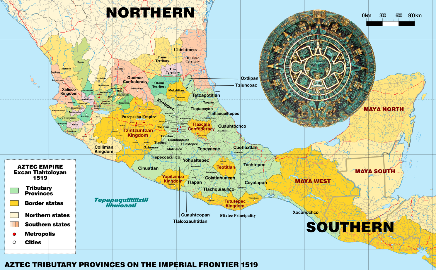
阿兹特克或阿兹台克是存在于14世纪至16世纪的墨西哥古文明,主要分布在墨西哥中部和南部,因阿兹特克人而得名。阿兹特克人包括墨西哥谷地的多个民族,以操纳瓦特尔语的族群为主。阿兹特克文明在政治上的基本单位是城邦,有些城邦组成政治联盟或政治邦联。其中,1427年建立的阿兹特克帝国最具影响力,帝国由墨西加城邦特诺奇蒂特兰、阿科尔瓦城邦特斯科科以及特帕内克城邦特拉科潘组成,政治影响力深远,领土范围极盛时东抵墨西哥湾,西至太平洋,南达恰帕斯和危地马拉。由于其强大的历史影响力,“阿兹特克”在狭义上常特指阿兹特克帝国;但广义来说,在殖民者入侵之前抑或是在西班牙殖民时代,中部美洲的所有纳瓦人政体和族群都可划作阿兹特克文明的一部分[1][2]。
阿兹特克人于约12世纪末由北方迁入墨西哥谷地,这里人口稠密,后来成为阿兹特克城邦崛起的中心。墨西加人是阿兹特克人的主要分支,他们在特斯科科湖中的岛礁建立起特诺奇蒂特兰城邦,并定居于此。1427年,特诺奇蒂特兰和特斯科科、特拉科潘结盟,联合击退了曾支配谷地的特帕内克城邦阿斯卡波察尔科。此三邦的联盟在后世被称为阿兹特克帝国,在随后的百余年内通过武力和贸易攻势展开扩张,成长为中部美洲势力范围最庞大的城邦联盟[3]。尽管被称为帝国,阿兹特克帝国事实上是一个以朝贡体系为基础的“朝贡帝国”,依托于扶植傀儡君主、政治联姻以及思想控制的方式间接控制其他城邦,强制其定期向宗主进贡,并不以军事驻防的方式实行直接统治[4]。帝国借此限制各邦同外部的贸易联系,使其属邦越发依赖帝国中央[5]。1519年,阿兹特克帝国的领土达到极盛,但一年后即迎来了欧洲人的历史性的访问。1520年,西班牙殖民者埃尔南·科尔特斯一行抵达中部美洲。科尔特斯利用中部美洲城邦间的矛盾,和阿兹特克的敌对城邦结盟,在1521年攻陷特诺奇蒂特兰,俘获并处决特拉托阿尼夸乌特莫克,并在特诺奇蒂特兰的废墟之上建起了现代墨西哥城。科尔特斯以此为中心实现对中部美洲全境的征服和殖民,将之纳入西班牙殖民帝国[6]。
近现代对阿兹特克文明的大规模研究始于19世纪,随着考古发掘和文献研究工作的进行,阿兹特克文明的文化、艺术和宗教逐渐为世人所了解。除了考古工作发现的古建筑和古物件外,既有的书面文献也起到重要作用,包括原住民手抄本、西班牙征服者的纪实文学,以及16世纪和17世纪由西班牙牧师或是有读写能力的阿兹特克人编撰的文化和历史文献等。十二卷手抄本佛罗伦萨手抄本是其中较为著名的文献,由方济各会修士贝尔纳迪诺·德萨阿贡结合一些阿兹特克人的描述写成,完整全面地记录了阿兹特克文明的文化、宗教、社会、经济和历史样貌。
德国地理学家冯·洪堡在19世纪早期率先用“阿兹特克”一词指代中部美洲纳瓦人以贸易、习俗、宗教、语言或政治联盟为纽带联系起来的文明集合体,“阿兹特克”一词就此被学界广泛接受和使用。不过,阿兹特克的具体界定也仍是一直以来学术讨论的主题之一[7]。根据中部美洲历史的断代法共识,900年至1521年的后古典时期内,中部美洲的绝大部分族群都拥有大体类似的文化烙印。因此,大部分普遍认为象征阿兹特克文明的文化元素并不是阿兹特克帝国的专属,因此对“阿兹特克文明”概念更贴切的理解是一种普遍存在的中部美洲文化体系[8],其农业以玉米栽培为主,社会形成皮尔利贵族和马塞瓦尔利平民的阶级分野,崇拜以特斯卡特利波卡、特拉洛克和克察尔科亚特尔为主的神系,历法系统由365天一周期的太阳历内嵌260天一周期的神圣历组成。与之相对应地,守护神祇维齐洛波奇特利、双子金字塔和阿兹特克陶制品则是阿兹特克人独有的文化符号[8]。现代墨西哥国家建立后,阿兹特克文化作为其国土上曾存在的重要文化而成为其现代国家认同的根基之一。特诺奇蒂特兰建城传说中雄鹰衔长蛇立于仙人掌之上的经典场面出现在墨西哥国旗和国徽上,为其重要的国家象征之一。
アステカ(Azteca、古典ナワトル語: Aztēcah)とは1428年頃から1521年までの約95年間北米のメキシコ中央部に栄えたメソアメリカ文明の国家。メシカ(古典ナワトル語: mēxihcah メーシッカッ)、アコルワ、テパネカの3集団の同盟によって支配され、時とともにメシカがその中心となった。言語は古典ナワトル語(ナワトル語)。
The Aztecs (/ˈæztɛks/) were a Mesoamerican culture that flourished in central Mexico in the post-classic period from 1300 to 1521. The Aztec peoples included different ethnic groups of central Mexico, particularly those groups who spoke the Nahuatl language and who dominated large parts of Mesoamerica from the 14th to the 16th centuries. Aztec culture was organized into city-states (altepetl), some of which joined to form alliances, political confederations, or empires. The Aztec empire was a confederation of three city-states established in 1427, Tenochtitlan, city-state of the Mexica or Tenochca; Texcoco; and Tlacopan, previously part of the Tepanec empire, whose dominant power was Azcapotzalco. Although the term Aztecs is often narrowly restricted to the Mexica of Tenochtitlan, it is also broadly used to refer to Nahua polities or peoples of central Mexico in the prehispanic era,[1] as well as the Spanish colonial era (1521–1821).[2] The definitions of Aztec and Aztecs have long been the topic of scholarly discussion, ever since German scientist Alexander von Humboldt established its common usage in the early nineteenth century.[3]
Most ethnic groups of central Mexico in the post-classic period shared basic cultural traits of Mesoamerica, and so many of the traits that characterize Aztec culture cannot be said to be exclusive to the Aztecs. For the same reason, the notion of "Aztec civilization" is best understood as a particular horizon of a general Mesoamerican civilization.[4] The culture of central Mexico includes maize cultivation, the social division between nobility (pipiltin) and commoners (macehualtin), a pantheon (featuring Tezcatlipoca, Tlaloc and Quetzalcoatl), and the calendric system of a xiuhpohualli of 365 days intercalated with a tonalpohualli of 260 days. Particular to the Mexica of Tenochtitlan was the patron God Huitzilopochtli, twin pyramids, and the ceramic ware known as Aztec I to IV.[5]
From the 13th century, the Valley of Mexico was the heart of dense population and the rise of city-states. The Mexica were late-comers to the Valley of Mexico, and founded the city-state of Tenochtitlan on unpromising islets in Lake Texcoco, later becoming the dominant power of the Aztec Triple Alliance or Aztec Empire. It was a tributary empire that expanded its political hegemony far beyond the Valley of Mexico, conquering other city states throughout Mesoamerica in the late post-classic period. It originated in 1427 as an alliance between the city-states Tenochtitlan, Texcoco, and Tlacopan; these allied to defeat the Tepanec state of Azcapotzalco, which had previously dominated the Basin of Mexico. Soon Texcoco and Tlacopan were relegated to junior partnership in the alliance, with Tenochtitlan the dominant power. The empire extended its reach by a combination of trade and military conquest. It was never a true territorial empire controlling a territory by large military garrisons in conquered provinces, but rather dominated its client city-states primarily by installing friendly rulers in conquered territories, by constructing marriage alliances between the ruling dynasties, and by extending an imperial ideology to its client city-states.[6] Client city-states paid tribute to the Aztec emperor, the Huey Tlatoani, in an economic strategy limiting communication and trade between outlying polities, making them dependent on the imperial center for the acquisition of luxury goods.[7] The political clout of the empire reached far south into Mesoamerica conquering polities as far south as Chiapas and Guatemala and spanning Mesoamerica from the Pacific to the Atlantic oceans.
The empire reached its maximal extent in 1519, just prior to the arrival of a small group of Spanish conquistadors led by Hernán Cortés. Cortés allied with city-states opposed to the Mexica, particularly the Nahuatl-speaking Tlaxcalteca as well as other central Mexican polities, including Texcoco, its former ally in the Triple Alliance. After the fall of Tenochtitlan on August 13, 1521 and the capture of the emperor Cuauhtemoc, the Spanish founded Mexico City on the ruins of Tenochtitlan. From there they proceeded with the process of conquest and incorporation of Mesoamerican peoples into the Spanish Empire. With the destruction of the superstructure of the Aztec Empire in 1521, the Spanish utilized the city-states on which the Aztec Empire had been built, to rule the indigenous populations via their local nobles. Those nobles pledged loyalty to the Spanish crown and converted, at least nominally, to Christianity, and in return were recognized as nobles by the Spanish crown. Nobles acted as intermediaries to convey tribute and mobilize labor for their new overlords, facilitating the establishment of Spanish colonial rule.[8]
Aztec culture and history is primarily known through archaeological evidence found in excavations such as that of the renowned Templo Mayor in Mexico City; from indigenous writings; from eyewitness accounts by Spanish conquistadors such as Cortés and Bernal Díaz del Castillo; and especially from 16th- and 17th-century descriptions of Aztec culture and history written by Spanish clergymen and literate Aztecs in the Spanish or Nahuatl language, such as the famous illustrated, bilingual (Spanish and Nahuatl), twelve-volume Florentine Codex created by the Franciscan friar Bernardino de Sahagún, in collaboration with indigenous Aztec informants. Important for knowledge of post-conquest Nahuas was the training of indigenous scribes to write alphabetic texts in Nahuatl, mainly for local purposes under Spanish colonial rule. At its height, Aztec culture had rich and complex mythological and religious traditions, as well as achieving remarkable architectural and artistic accomplishments.
Les Aztèques, ou Mexicas (du nom de leur capitale, Mexico-Tenochtitlan), étaient un peuple amérindien du groupe nahua, c'est-à-dire de langue nahuatl.
Ils s'étaient définitivement sédentarisés dans le plateau central du Mexique, dans la vallée de Mexico, sur une île du lac Texcoco, vers le début du XIVe siècle. Au début du XVIe siècle, ils avaient atteint un niveau de civilisation parmi les plus avancés d'Amérique et dominaient, avec les autres membres de leur Triple alliance, le plus vaste empire de la Mésoamérique postclassique. Leur seul vrai rival était le royaume tarasque.
L'arrivée, en 1519, des conquistadors menés par Hernán Cortés scella la fin de leur règne. Le 13 août 1521, les Espagnols, aidés par un grand nombre d’alliés autochtones, finirent par remporter le siège de Tenochtitlan et par capturer le dernier dirigeant aztèque, Cuauhtémoc. La civilisation aztèque s'est alors rapidement acculturée à l'époque coloniale ; il en résulte un profond syncrétisme dans le Mexique actuel entre les héritages aztèques (et, plus largement, mésoaméricains) et espagnols.
Les études de cette civilisation précolombienne se fondent sur les codex mésoaméricains, livres écrits par les autochtones sur papier d'amate, les témoignages des conquistadors, comme Hernán Cortés et Bernal Díaz del Castillo, les travaux des chroniqueurs du XVIe et XVIIe siècles, comme le codex de Florence compilé par le moine franciscain Bernardino de Sahagún avec l'aide de collaborateurs aztèques, ainsi que, depuis la fin du XVIIIe siècle, les recherches archéologiques, grâce aux fouilles comme celles du Templo Mayor de la ville de Mexico.
I Mexica (pron. mescìca; Nahuatl: Mēxihcah [meːˈʃiʔkaʔ], singolare Mēxihcatl) o Mexicas — meglio noti come Aztechi nella storiografia occidentale - furono una delle grandi civiltà precolombiane, la più florida e viva al momento del contatto con gli Spagnoli. Provenienti dalla California settentrionale, si svilupparono nella regione mesoamericana dell'attuale Messico dal secolo XIV al XVI.
Il nome con cui essi stessi si indicavano è "Mexica" o "Tenochca", e non Aztechi, non a caso Mexica è tuttora il termine usato per definire i loro discendenti; il termine Azteco è invece stato coniato solo molti secoli dopo dal geografo tedesco Alexander von Humboldt per distinguere queste popolazioni precolombiane dall'insieme dei Messicani moderni. Spesso con il termine "azteco" ci si riferisce esclusivamente al popolo residente a Tenochtitlán (dove oggi si trova Città del Messico), situata su un'isola del lago Texcoco, che faceva riferimento a se stessa come Mēxihcah Tenochcah [meːˈʃiʔkaʔ teˈnot͡ʃkaʔ] o Cōlhuah Mēxihcah [ˈkoːlwaʔ meːˈʃiʔkaʔ].
Talvolta il termine comprende anche gli abitanti delle due principali città-stato alleate di Tenochtitlan, gli Acolhua di Texcoco e i Tepanechi di Tlacopan, che insieme con i Mexica formavano la Triplice alleanza azteca spesso conosciuta come "impero azteco". In altri contesti, "azteco" può riferirsi a tutti i vari stati della città e dei loro popoli che hanno condiviso gran parte della loro storia etnica e tratti culturali con i Mexica, con gli Acolhua e con i Tepanechi e che spesso utilizzavano la lingua nahuatl come lingua franca. In questo senso si può parlare di una civiltà azteca comprensiva di tutti i modelli culturali comuni per la maggior parte dei popoli che abitarono il Messico centrale nel periodo tardo post-Classico.
A partire dal XIII secolo, la Valle del Messico è stata il cuore della civiltà azteca; qui la capitale della Triplice alleanza azteca, la città di Tenochtitlan, fu costruita su isole nel lago Texcoco. La Triplice Alleanza formò un impero tributario che espanse la propria egemonia politica ben oltre la Valle del Messico, conquistando altre città di tutto il Mesoamerica. Al suo apice, la cultura azteca vantava ricche e complesse tradizioni mitologiche e religiose, oltre ad aver raggiunto la capacità di realizzare notevoli manufatti architettonici e artistici. Nel 1521 Hernán Cortés, conquistò Tenochtitlan e sconfisse la Triplice alleanza azteca che al momento si trovava sotto la guida di Montezuma II (vedi Conquista dell'impero azteco). Successivamente, gli spagnoli fondarono il nuovo insediamento di Città del Messico sul sito della capitale azteca in rovina; da qui poi procedettero con il processo di colonizzazione dell'America Centrale.
La cultura e la storia azteca sono conosciute principalmente attraverso le testimonianze archeologiche rinvenute negli scavi, come quello del famoso Templo Mayor a Città del Messico; da codici scritti su corteccia; da testimonianze oculari dei conquistadores spagnoli come Hernán Cortés e Bernal Díaz del Castillo; e soprattutto dalle descrizioni del XVI e XVII secolo della cultura e della storia scritti da ecclesiastici spagnoli e da letterati Aztechi, come il famoso Codice Fiorentino compilato dal frate francescano Bernardino de Sahagún con l'aiuto di informatori originari aztechi.
Los mexicas (del náhuatl mēxihcah ![]() [meː'ʃiʔkaʔ] (?·i), «mexicas»1) —llamados en la historiografía tradicional aztecas2— fueron un pueblo mesoamericano de filiación nahua que fundó México-Tenochtitlan y hacia el siglo XV en el periodo posclásico tardío se convirtió en el centro de uno de los Estados más extensos que se conoció en Mesoamérica, asentado en un islote al poniente del lago de Texcoco, sobre los márgenes centro y el sur de los lagos, como en Huexotla, Coatlinchan, Culhuacan, Iztapalapa, Chalco, Xico, Xochimilco, Tacuba, Azcapotzalco, Tenayuca y Xaltocan, hacia finales del Posclásico Temprano (900-1200),3 hoy prácticamente desecado. Sobre el islote se asienta la actual Ciudad de México, y que corresponde a la misma ubicación geográfica. Aliados con otros pueblos de la cuenca lacustre del valle de México —Tlacopan y Texcoco—, los mexicas sometieron a varias poblaciones indígenas que se asentaron en el centro y sur del territorio actual de México agrupados territorialmente en altépetl.
[meː'ʃiʔkaʔ] (?·i), «mexicas»1) —llamados en la historiografía tradicional aztecas2— fueron un pueblo mesoamericano de filiación nahua que fundó México-Tenochtitlan y hacia el siglo XV en el periodo posclásico tardío se convirtió en el centro de uno de los Estados más extensos que se conoció en Mesoamérica, asentado en un islote al poniente del lago de Texcoco, sobre los márgenes centro y el sur de los lagos, como en Huexotla, Coatlinchan, Culhuacan, Iztapalapa, Chalco, Xico, Xochimilco, Tacuba, Azcapotzalco, Tenayuca y Xaltocan, hacia finales del Posclásico Temprano (900-1200),3 hoy prácticamente desecado. Sobre el islote se asienta la actual Ciudad de México, y que corresponde a la misma ubicación geográfica. Aliados con otros pueblos de la cuenca lacustre del valle de México —Tlacopan y Texcoco—, los mexicas sometieron a varias poblaciones indígenas que se asentaron en el centro y sur del territorio actual de México agrupados territorialmente en altépetl.
Los mexicas se caracterizaban por la explotación de cultivos altamente simbióticos (dependencia a la manipulación humana,4556 como maíz, chile, calabaza, frijol, etc.), el uso extensivo de plumas para la confección de vestimentas, el uso de calendarios astronómicos (uno ritual de 260 días y un civil de 365), una sofisticada metalurgia prehispánica ornamental y militar basada principalmente en el bronce, oro y plata;7 una escritura en forma de pictogramas el cual era usado para la documentación de hechos y el cálculo de obras arquitectónicas el cual estaba basado en un sistema métrico propio,8 que para mediciones de terrenos es comparable con otros sistemas de medida de la Edad Moderna,9 el uso extensivo de productos derivados de las cactáceas y agaves, y el uso de cerámico ígneo (obsidiana) para fines quirúrgicos y bélicos.
Ацте́ки, или асте́ки[1] (самоназв. mēxihcah [meː'ʃiʔkaʔ]), — индейский народ в центральной Мексике. Численность современных науа, как ещё называют ацтеков, — свыше 1,5 млн человек. Цивилизация ацтеков (XIV—XVI века) обладала богатой мифологией и культурным наследием. Столицей империи ацтеков был город Теночтитлан, расположенный на озере Тескоко, там, где сейчас располагается город Мехико.
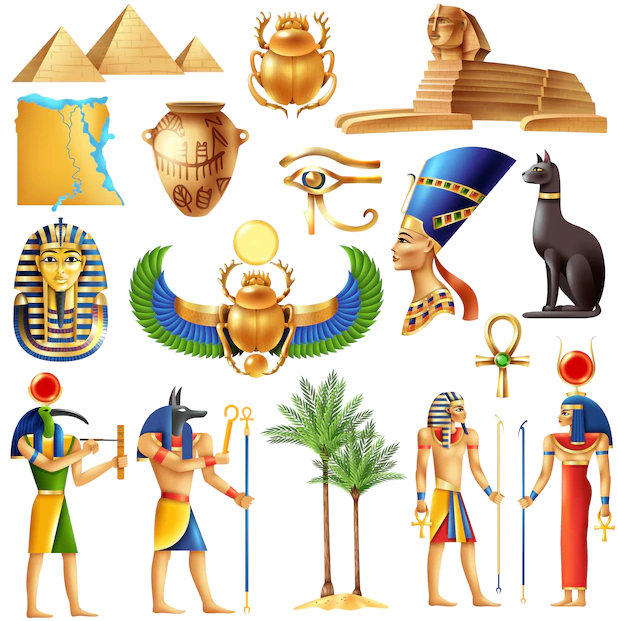 Ancient Egypt
 History
E 2500 - 2000 BC
History
F 2000 - 1500 BC
History
G 1500 - 1000 BC
History
H 1000 - 500 BC
Mesopotamian civilization
Civilization
History
E 2500 - 2000 BC
History
F 2000 - 1500 BC
History
G 1500 - 1000 BC
History
H 1000 - 500 BC
Mesopotamian civilization
Civilization
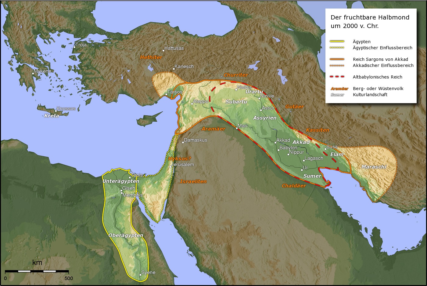
Das Reich Elam (sumerisch NIM.MAKI, akkadisch KURElammatum; griechisch Ἐλυμαία Elymaía oder Ἐλυμαΐς Elymaḯs) mit der Hauptstadt Susa (bzw. Schusim) lag östlich des Tigris in einem Gebiet, das heute Chusistan (im heutigen Iran) genannt wird. In seiner wechselvollen Geschichte – zwischen 3000 und 640 v. Chr. – wurde es immer wieder von den Mächten des Zweistromlandes (Sumerer, Akkader, Babylonier, Assyrer) erobert und fiel seinerseits häufig in Mesopotamien ein.
Der Landesname Elam entstammt der griechischen Bezeichnung Elymaía, die wiederum dem hebräischen Wort Elam entlehnt wurde. Die Eigenbezeichnung war Haltamti oder Hatamti und bedeutet „Land der Könige, Fürstenland“.
埃兰(英语:Elam),又译以拦、厄蓝或伊勒姆,是亚洲西南部的古老君主制城邦国家,位于今天伊朗的西南部,波斯湾北部,底格里斯河东部,现为伊朗的胡齐斯坦及伊拉姆省。埃兰是伊朗的最早文明,起源于伊朗高原以外的埃兰地区。一般认为埃兰国名出自境内哈尔答第城邦(意谓“神的国家”)。此名在《圣经》广为流传,故沿用至今。公元前三千年以前,在底格里斯河东岸建国,以善战的人民著称,圣经记载是诺亚儿子闪的儿孙及其后裔。
埃兰地区曾有许多君主制城邦国,其中最重要的有阿万(Awan)、苏萨、西马什(Simash)、安善(Anshan)等。
埃兰历史可以分为三个时期:古埃兰时期、中埃兰时期与新埃兰时期。
エラム (Elam) は古代オリエントで栄えた国家、または地方の名。紀元前3200年頃から紀元前539年までの間、複数の古代世界の列強国を出現させた。
エラムと呼ばれたのは、メソポタミアの東、現代のフーゼスターンなどを含むイラン高原南西部のザグロス山脈沿いの地域である。エラム人自身は自らをハルタミ (Haltami) と呼び、土地を指す際にはハルタムティ(Haltamti、後に訛ってアタムティAtamti)と呼んだ。シュメール語のエラムはこれの転訛したものである[1]。メソポタミアという古代文明世界の中心地に隣接したために、その文化的影響を強く受けたが、砂漠や湿地帯によって交通が困難であったために、政治的にはイラン高原地帯との関わりが深かった。エラム人は系統不明の言語エラム語を話す人々であり、メソポタミアでウルク古拙文字(楔形文字の元になったと考えられている絵文字)が発明されてから程なく、エラムでも原エラム文字と呼ばれる絵文字が発明された。この原エラム文字で書かれた文章は現在のアフガニスタンに近い地域からも見つかっており、エラム文化はイラン高原各地に影響を与えていたと考えられる。また、ほぼ同時代にエラム楔形文字も使われているが、それらの関係は全く解明されていない。メソポタミアの王朝はたびたびエラムに侵入して、これを支配下に置いた。一方でエラム人もメソポタミアへの介入を繰り返し、バビロニアの王朝をいくつも滅ぼしている。紀元前2000年紀に入ると、エラム人も楔形文字を使って記録を残すようになり、多くの情報がわかる。エラムの歴史で中心的役割を果たした都市はアンシャン、そしてスサである。スサを中心とした地方はギリシア人たちにはスシアナとよばれた。エラム人の残した文化や政治制度は、メディアやペルシアに大きな影響を及ぼした。
エラム人は、オリエントのほかの地域とは異なる独特の相続制度を持っていた。即ち、王位は親子ではなく、まず兄弟によって相続されていくのである。この相続制度はかなり後の時代にまで継承され、異民族の侵入によっても基本的に変化しなかった。
Elam (/ˈiːləm/; Elamite: ????? haltamti; Sumerian: ??? NIM.MAki; Hebrew: עֵילָם ʿÊlām) was an ancient Pre-Iranian civilization centered in the far west and southwest of what is now modern-day Iran, stretching from the lowlands of what is now Khuzestan and Ilam Province as well as a small part of southern Iraq. The modern name Elam stems from the Sumerian transliteration elam(a), along with the later Akkadian elamtu, and the Elamite haltamti. Elamite states were among the leading political forces of the Ancient Near East.[1] In classical literature Elam was also known as Susiana (US: /ˌsuːʒiˈænə/ UK: /ˌsuːziˈɑːnə/; Ancient Greek: Σουσιανή Sousiānḗ), a name derived from its capital Susa.[2]
Elam was part of the early urbanization during the Chalcolithic period (Copper Age). The emergence of written records from around 3000 BC also parallels Sumerian history, where slightly earlier records have been found.[3][4] In the Old Elamite period (Middle Bronze Age), Elam consisted of kingdoms on the Iranian plateau, centered in Anshan, and from the mid-2nd millennium BC, it was centered in Susa in the Khuzestan lowlands.[5] Its culture played a crucial role during the Persian Achaemenid dynasty that succeeded Elam, when the Elamite language remained among those in official use. Elamite is generally considered a language isolate unrelated to the much later arriving Persian and Iranic languages. In accordance with geographical and archaeological matches, some historians argue that the Elamites comprise a large portion of the ancestors of the modern day Lurs,[6][7] whose language, Luri, split from Middle Persian.
L'Élam est un ancien pays occupant la partie sud-ouest du plateau Iranien, autour des actuelles provinces du Khouzistan et du Fars, qui correspondent à ses deux principales régions, celle de Suse et celle d'Anshan/Anzan. Le pays élamite, attesté par des textes allant de la fin du IVe millénaire av. J.‑C. au Ier millénaire ap. J.-C., recouvrit des réalités géographiques et politiques qui différent pendant sa longue histoire. Il fut parfois divisé en plusieurs entités politiques, surtout jusqu'au IIIe millénaire av. J.‑C., mais aussi plusieurs fois par la suite, et il connut par contre des phases d'unification, sous l'impulsion de puissantes dynasties (notamment les Sukkalmah, Igehalkides, Shutrukides), surtout au IIe millénaire av. J.‑C. À partir du Ier millénaire av. J.‑C., l'Élam se réduit à sa partie occidentale, autour de la Susiane, la partie orientale étant occupée par les Perses, qui lui donnèrent le nom qu'elle a gardé depuis (Perse/Fars). Le pays élamite perdit son autonomie politique après son combat contre l'Assyrie et sa conquête par les Perses, même s'il semble avoir revécu plusieurs siècles plus tard, à travers le royaume d'Élymaïde. Des survivances de cet ancien pays et de son peuple semblent encore attestées jusqu'au début du IIe millénaire ap. J.-C.
L'histoire de l'Élam est difficilement dissociable de celle de la Mésopotamie voisine, qui exerça sur ces territoires une forte influence. Les sources mésopotamiennes sont essentielles pour redécouvrir la civilisation élamite, complétées par celles provenant de sites de la région, avant tout de Suse. Elles laissent apparaître un ensemble de régions hétérogènes présentant des originalités culturelles (perceptibles dans le culte religieux et l'art), mais beaucoup d'aspects restent obscurs en l'état actuel des connaissances scientifiques (par exemple l'organisation politique, les activités de production, la mythologie).
Elam è il nome convenzionale con cui si fa riferimento ad una civiltà sviluppatasi dal III al I millennio a.C. nell'area corrispondente all'attuale Iran occidentale, nelle regioni del Khuzistan e del Fars. I due centri di riferimento furono Susa, nell'estensione sud-orientale del bassopiano mesopotamico, e Anshan, identificato con il sito di Tall-i Malyan, nella piana di Marvdasht (a nord-est di Shiraz), la stessa in cui più tardi fu costruita Persepoli.
Elam (en elamita antiguo Haltamti;1 akkadio Elamtu; persa antiguo Hujiyā; persa moderno تمدن عیلام ―‘cultura de Elam’―), se situaba al este de Sumeria y Acad, en el actual suroeste de Irán. Los elamitas llamaban a su país Haltamti (en elamita tardío, Atamti), del cual sus vecinos acadios adaptaron como Elamtu. El alto Elam fue posteriormente más y más identificado por su baja capital, Susa, y geógrafos posteriores a Ptolomeo la llamaron Susiana. El término del antiguo persa Hujiyā sobrevive en el topónimo Juzestán, que es la provincia junto con la de Lorestán en la que se sitúan los restos del antiguo Elam. En diversos períodos existieron diversos imperios elamitas y en otros momentos estuvieron sometidos a imperios vecinos.
Excavaciones realizadas en Susa han proporcionado numerosos documentos escritos con caracteres cuneiformes que permiten reconstruir la más antigua historia y religión de los elamitas. El idioma elamita ―según se ha establecido a partir de los registros cuneiformes― no está relacionado con los cuatro grupos lingüísticos vecinos: camito-semítico, sumerio e indoeuropeo (en concreto, del grupo iranio temprano). Algunos expertos creen que la lengua de los elamitas está emparentada con las actuales lenguas drávidas del sur de la India (ver lenguas elamo-drávidas).23 Sin embargo, aun es oscura la relación de los elamitas con otras naciones conocidas.
Элам (также Елам[1]; шум. Ним, аккад. Эламту, самоназвание — Haltamti) — историческая область и древнее государство (3 тысячелетие — сер. VI в. до н. э.) на юго-западе современного Ирана (провинции Хузестан и Лурестан).


Als Andenzivilisation, auch Altperu[1], werden komplexe Gesellschaften (Zivilisationen) bezeichnet, die sich im Andenraum einschließlich der Pazifikküste im Westen Südamerikas vor der Ankunft der Europäer entwickelten. Neben Peru umfasst dieser Kulturraum insbesondere Kolumbien, Ecuador, Bolivien, Chile und Argentinien. Der Andenraum mit seiner trockenen Pazifikküste, den östlich gelegenen feuchtwarmen Gebieten des Amazonasregenwaldes und den hohen beschneiten Gipfel der Anden bot mit seiner sich zwischen 2.500 und 3.500 m erstreckenden Sierra günstige landwirtschaftliche Bedingungen (gleichmäßiges Klima, fruchtbarer Boden) und begünstigte so die Besiedlung des Andenraums. Ähnliches galt für den Altiplano, ein abflussloses steppenartiges Gebiet zwischen 3.000 und 4.500 m mit dem Titicacasee. Wann die ersten Menschen nach Südamerika einwanderten, ist unbekannt. Einige Forscher nehmen an, dass der Andenraum über die Landenge von Panama besiedelt wurde.
安第斯文明是指位于哥伦比亚南部的安地斯山脉、秘鲁沿海沙漠以及智利和阿根廷西北部的由多种文化和民族组成的文明。秘鲁的小北文明是美洲已知最古老的文明,它的历史可追溯到公元前3200年。
