漢德百科全書 | 汉德百科全书
 Turkey

 Egypt
Egypt
 Algeria

 Eat and Drink
 *Olives/Olive oil
 Greece
 Italy
Italy

 Agriculture, forestry, livestock, fishing
 Morocco
 Portugal
 Spain
Spain
 Syria
Syria
 Tunisia
 Turkey

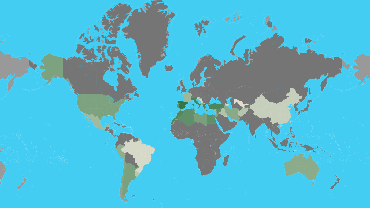
| Rank | Country | Production (Tonnes) | Production per Capita (Kg) | Harvasted Area (Ha) | Yield (Kg/Ha) |
|---|---|---|---|---|---|
| 1 | Spain | 6,559,884 | 141 | 2,573,473 | 2,549 |
| 2 | Greece | 2,343,383 | 218 | 887,177 | 2,641 |
| 3 | Italy | 2,092,175 | 34.6 | 1,165,562 | 1,795 |
| 4 | Turkey | 1,730,000 | 21.4 | 845,542 | 2,046 |
| 5 | Morocco | 1,416,107 | 40.7 | 1,008,365 | 1,404 |
| 6 | Syria | 899,435 | 49.2 | 765,603 | 1,175 |
| 7 | Tunisia | 700,000 | 61.2 | 1,646,060 | 425 |
| 8 | Algeria | 696,962 | 16.4 | 424,028 | 1,644 |
| 9 | Egypt | 694,309 | 7.1 | 67,293 | 10,318 |
| 10 | Portugal | 617,610 | 60.0 | 355,075 | 1,739 |
| 11 | Libya | 188,975 | 29.2 | 357,797 | 528 |
| 12 | Argentina | 175,094 | 3.9 | 61,942 | 2,827 |
| 13 | United States of America | 159,600 | 0.49 | 14,164 | 11,268 |
| 14 | Lebanon | 118,146 | 19.4 | 62,297 | 1,897 |
| 15 | Jordan | 115,813 | 11.3 | 63,963 | 1,811 |
| 16 | Chile | 111,481 | 6.3 | 20,343 | 5,480 |
| 17 | Albania | 99,075 | 34.5 | 38,889 | 2,548 |
| 18 | Palestinian Territories | 95,044 | | 66,645 | 1,426 |
| 19 | Israel | 91,000 | 10.2 | 33,700 | 2,700 |
| 20 | Iran | 85,049 | 1.0 | 66,915 | 1,271 |
| 21 | Australia | 75,083 | 3.0 | 32,747 | 2,293 |
| 22 | Peru | 56,157 | 1.8 | 17,119 | 3,281 |
| 23 | Croatia | 31,183 | 7.4 | 18,184 | 1,715 |
| 24 | France | 27,102 | 0.40 | 17,354 | 1,562 |
| 25 | Mexico | 21,650 | 0.17 | 5,094 | 4,250 |
| 26 | Cyprus | 13,499 | 15.8 | 10,612 | 1,272 |
| 27 | Macedonia | 12,369 | 6.0 | 5,852 | 2,114 |
| 28 | El Salvador | 10,840 | 1.6 | 5,227 | 2,074 |
| 29 | Iraq | 9,332 | 0.24 | 2,294 | 4,068 |
| 30 | Afghanistan | 7,647 | 0.24 | 2,200 | 3,476 |
| 31 | Uruguay | 6,159 | 1.8 | 2,985 | 2,063 |
| 32 | Taiwan | 2,621 | 0.11 | 318 | 8,256 |
| 33 | China | 2,621 | 0.00188 | 318 | 8,256 |
| 34 | Slovenia | 1,662 | 0.80 | 1,173 | 1,417 |
| 35 | Azerbaijan | 1,586 | 0.16 | 2,979 | 533 |
| 36 | Brazil | 647 | 0.00309 | 574 | 1,127 |
| 37 | Bosnia and Herzegovina | 359 | 0.095 | 254 | 1,416 |
| 38 | Montenegro | 250 | 0.40 | 90.0 | 2,778 |
| 39 | Uzbekistan | 116 | 0.00355 | 117 | 987 |
| 40 | Kuwait | 60.0 | 0.014 | 35.0 | 1,702 |
| 41 | Malta | 30.0 | 0.063 | 28.0 | 1,064 |

Der Kaukasus (russisch Кавказ, Kawkas; georgisch კავკასიონი, Kawkasioni, armenisch Կովկաս, Kowkas, aserbaidschanisch Qafqaz, türkisch Kafkas, von altgriechisch Καύκασος)[1] ist ein etwa 1100 Kilometer langes, von Westnordwest nach Ostsüdost verlaufendes Hochgebirge in Eurasien zwischen Schwarzem und Kaspischem Meer. Es ist Teil des Alpidischen Gebirgssystems und unterteilt sich in die drei Gebirgsketten Großer Kaukasus, Kleiner Kaukasus und Talysch-Gebirge. Der Kaukasus ragt bis zu einer Höhe von 5642 Metern über dem Meeresspiegel auf und hat eine mittlere Höhe von 602 Metern.[2] Er befindet sich auf den Territorien Russlands, Georgiens, Armeniens und Aserbaidschans. Im Jahr 2000 lebten etwa 30,6 Millionen Menschen in diesem Gebirge und seiner näheren Umgebung.
高加索山脉(俄语:Кавказские горы,格鲁吉亚语:კავკასიონი,亚美尼亚语:Կավկազ,阿塞拜疆语:Qafqaz),呈东西走向,在黑海与里海之间,是俄罗斯和格鲁吉亚、阿塞拜疆等国的国界线。其最高峰为厄尔布鲁士峰,其海拔为5642米(18510呎),同时也是欧洲第一高峰。
大高加索山脉是亚洲和欧洲的地理分界线,从黑海东北岸,即在俄罗斯塔曼半岛至索契附近开始往东南偏东延伸,直达里海附近的巴库为止。 而小高加索山脉则几乎与大高加索平行排列,两者由隔开了科尔基斯和库拉-阿拉斯低地的苏拉姆山脉所连接。 在小高加索山脉东南方矗立着塔雷什山脉,是厄尔布尔士山脉的西北部分。 小高加索山脉和亚美尼亚高原构成了外高加索高地。
コーカサス山脈(コーカサスさんみゃく)は、黒海からカスピ海まで東西に走る山脈である。ロシア語からカフカース山脈ともよばれる。ロシアでは大カフカース山脈(Большой Кавказ)と呼び、南の小カフカース山脈(Малый Кавказ)と区別している。
ギリシア神話では、コーカサスは世界を支える柱のうちの一つでゼウスがプロメーテウスを鎖で繋いだ場所でもある。
The Caucasus Mountains[a] are a mountain system in West Asia between the Black Sea and the Caspian Sea in the Caucasus region.
The Caucasus Mountains include the Greater Caucasus in the north and Lesser Caucasus in the south. The Greater Caucasus runs west-northwest to east-southeast, from the Caucasian Natural Reserve in the vicinity of Sochi on the northeastern shore of the Black Sea nearly to Baku on the Caspian Sea. The Lesser Caucasus runs parallel to the Greater about 100 km (62 mi) south.[1] The Greater and Lesser Caucasus ranges are connected by the Likhi Range, and to the west and east of the Likhi Range lie the Colchis Plain and the Kur-Araz Lowland. The Meskheti Range is a part of the Lesser Caucasus system. In the southeast the Aras River separates the Lesser Caucasus from the Talysh Mountains which straddle the border of southeastern Azerbaijan and Iran. The Lesser Caucasus and the Armenian Highland constitute the Transcaucasian Highland, which at their western end converge with the highland plateau of Eastern Anatolia in the far north east of Turkey. The highest peak in the Caucasus range is Mount Elbrus in the Greater Caucasus, which rises to a height of 5,642 metres (18,510 ft) above sea level. Mountains near Sochi hosted part of the 2014 Winter Olympics.
La catena del Caucaso è un sistema montuoso che si estende per circa 1100–1200 km tra il mar Nero e il mar Caspio ed è a volte considerata il limite sud-orientale del continente Europa (in luogo della depressione del Kuma-Manyč indicata come tale nel 1730 dallo zar di Russia in seguito agli studi di Philip Johan von Strahlenberg).
La cordillera del Cáucaso1 (en ruso: Kavkazskiy Khrebet)? es una gran cordillera localizada entre el mar Negro y el mar Caspio, en la región del Cáucaso, entre las cuencas del río Kubán y del río Terek, al norte de Anatolia, y el río Irán, al sur. Muchas veces ha sido considerado el límite sudeste de Europa.
Muchas de las cimas de esta cordillera superan los 4.500 m, siendo la más alta el monte Elbrus, en el Gran Cáucaso. La cordillera es una gran barrera geográfica, casi infranqueable, con pocos pasos y collados, siendo los más importantes el Daryal y el Mamison. Posee considerables recursos hidráulicos como los del Kura y valiosas reservas de petróleo y gas natural.
Administrativamente, el Cáucaso pertenece a Armenia, Azerbaiyán, Georgia y Rusia (a las repúblicas autónomas de Karacháevo-Cherkesia, Kabardino-Balkaria, Ingusetia, Osetia del Norte - Alania, Chechenia y Daguestán).
Las montañas cercanas a Sochi fueron la sede de parte de los Juegos Olímpicos de Invierno de 2014.
Кавка́зские го́ры (абх. Кавказаа ашьхақәа, авар. Кавказалъул мугIрул, адыг. Къаукъаз къурш, азерб. Qafqaz dağları, арм. Կովկասյան լեռնաշղթա, груз. კავკასიონი, дарг. Кавказла дубурти, ингуш. Кавказа лоамаш, Даькъастен лоамаш, кабард.-черк. Къаукъаз къурш, карач.-балк. Кавказ таула, кум. Кавказ тавлар, лезг. Къавкъаз, осет. Кавказы хæхтæ, рут. Кавказад банбыр, чеч. Кавказан лаьмнаш) — горная система, расположенная в Евразии между Чёрным и Каспийским морями. Этимология названия не установлена[1]. Разделяется на две горные системы: Большой Кавказ и Малый Кавказ. Кавказ часто делят на Северный Кавказ и Закавказье, границу между которыми проводят по Главному, или Водораздельному, хребту Большого Кавказа, занимающему центральное положение в горной системе.
Большо́й Кавказ простирается более чем на 1100 км с северо-запада на юго-восток, от района Анапы и Таманского полуострова Чёрного моря до Апшеронского полуострова на побережье Каспия, рядом с Баку. Максимальной ширины Большой Кавказ достигает в районе меридиана Эльбруса (почти 180 км). В осевой части расположен Главный Кавказский (или Водораздельный) хребет, к северу от которого простирается ряд параллельных хребтов (горных цепей), в том числе моноклинального (куэстового) характера (см. Большой Кавказ). Южный склон Большого Кавказа большей частью состоит из кулисообразных хребтов, примыкающих к Главному Кавказскому хребту. Традиционно Большой Кавказ делится на 3 части: Западный Кавказ (от Чёрного моря до Эльбруса), Центральный Кавказ (от Эльбруса до Казбека) и Восточный Кавказ (от Казбека до Каспийского моря).
Наиболее известные вершины (такие, как Эльбрус (5642 м) и Казбек (5033 м)) покрыты вечными снегами и ледниками. Большой Кавказ — регион с большим современным оледенением. Общая численность ледников составляет около 2 050, занимаемая ими площадь составляет приблизительно 1 400 км². Больше половины оледенения Большого Кавказа сосредоточено на Центральном Кавказе (50 % от числа и 70 % от площади оледенения). Крупными центрами оледенения являются гора Эльбрус и Безенгийская стена (с ледником Безенги, 17 км).
От северного подножия Большого Кавказа до Кумо-Манычской впадины простирается Предкавказье с обширными равнинами и возвышенностями. К югу от Большого Кавказа расположены Колхидская и Кура-Араксинская низменности, Внутреннекартлийская равнина и Куринская впадина, в пределах которой находятся Алазань-Авторанская долина и Кура-Араксинская низменность. В юго-восточной части Кавказа — Талышские горы (высота до 2492 м) с прилегающей Ленкоранской низменностью. В середине и на западе южной части Кавказа находится Закавказское нагорье, состоящее из хребтов Малого Кавказа и Армянского нагорья (высшая точка — г. Арагац, 4090 м). Малый Кавказ соединяется с Большим Кавказом Лихским хребтом, на западе отделяется от него Колхидской низменностью, на востоке — Куринской впадиной. Протяжённость — около 600 км, высота — до 3724 м.


 *Mediterranean Sea
 Egypt
Egypt
 Algeria
 Belgium
 Bulgaria
 Germany
 France

 History

 History
 H 1000 - 500 BC

 History
 I 500 - 0 BC

 History
 J 0 - 500 AD
 Israel
 Italy
Italy
 Jordan
 Croatia
 Libanon
 Libya
Libya
 Morocco
 Netherlands
 Portugal
 Romania
 Switzerland
 Serbia
 Syria
Syria
 Tunisia
 Turkey
 Hungary
 United Kingdom

 Civilization
 Cyprus

Als römische Architektur bezeichnet man die Baukunst der Römer zur Zeit der römischen Republik und der Kaiserzeit. Die römische Architekturgeschichte umfasst damit einen Zeitraum von etwa neun Jahrhunderten (500 v. Chr.–400 n. Chr.). Die Epochen der römischen Architektur werden nach einzelnen Herrschern, Dynastien oder retrospektiv formulierten historischen Zeitabschnitten benannt. Die seitens der Klassischen Archäologie geprägten Epochen- oder Stilbegriffe finden keine Entsprechungen in der schriftlichen antiken Überlieferung, entsprechen also nicht antiker Wahrnehmung und Einteilung.
古罗马建筑(英语:Ancient Roman architecture),是指由古罗马人创造并且扩展到地中海沿岸其所控制疆域的一种新风格的建筑艺术,经常简称为罗马建筑(英语:Roman architecture)。它直接继承了古希腊晚期的建筑成就,而且将其向前大大推进,使之在1到3世纪达到奴隶制时代全世界建筑的顶峰[1][2]。在西方学术界传统上特指古罗马共和国与帝国时期的建筑[3],中文学术界定义较为宽泛,有时可以包括前期的伊特鲁里亚建筑[4],也可以包括分裂之后的西罗马帝国建筑[2],但是一般不包含东罗马帝国建筑。
 Egypt
Egypt
 Australia
 Belgium
 Brazil
 China
China
 Denmark
 Germany
 Finland
 France
 Greece

 Hand in Hand

 Hand in Hand
 Driver's license
 India
India
 Indonesia
 Italy
Italy
 Japan
Japan
 Canada
 Kasachstan
 Croatia
 Malaysia

 Mongolei
 New Zealand
 Netherlands
 Useful info
 Austria
 Portugal
 Republic of Korea
 Russia
 Saudi Arabia
 Sweden
 Switzerland
 Singapore
 Spain
Spain
 South Africa
 Thailand
 Czech Republic
 Turkey
 Hungary

 Vacation and Travel
 United Arab Emirates
 United States
 United Kingdom

国际驾驶执照(International Driving Permit)依照1949年日内瓦国际道路交通公约及1968年维也纳国际道路交通公约,由公约签署国政府签发,方便本国驾驶员在其他签约国驾驶私人车辆。国际驾驶执照为附加在一国驾驶执照之上的一本附加多国语言的说明,标注了驾驶人的基本信息以及允许驾驶的对应车辆种类等,解决驾驶员与其他国家的交通管理部门之间的沟通障碍。国际驾照不能独立存在,当驾驶员同时持有一国驾照与该国政府签发的国际驾照时,此国际驾照才视作有效。[1]
国际驾驶执照之内容及格式依照维也纳道路交通会议制订,但并非各国均批准该公约。
Ein Internationaler Führerschein ist ein Dokument, das von den Straßenverkehrsbehörden oder Automobilclubs[1] eines Landes aufgrund zwischenstaatlicher Verträge ausgestellt wird. Er soll vor allem der Polizei eines anderen Landes die Feststellung ermöglichen, ob ein ausländischer Kraftfahrer die Fahrerlaubnis hat, die für sein aktuelles Fahrzeug erforderlich ist.
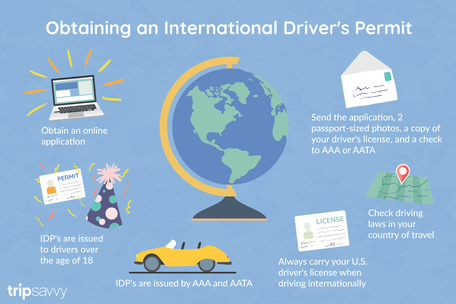
An International Driver's Permit (IDP) allows you to drive a vehicle in another country, as long as you also have a valid driver's license issued by your state. It is also recognized as a proper form of identification in over 175 countries and by many major car rental companies internationally.
Getting an International Driver's Permit (sometimes incorrectly called an international driver's license) can take anywhere from a day to a few weeks, depending on whether you're going through walk-in processing or applying via mail, so make sure to plan ahead if you're planning to drive on your international trip. There are only two locations in the United States that issue these documents: The American Automobile Association (AAA) and the American Automobile Touring Alliance (AATA).
In the United States, International Driver Permits (IDPs) are only issued by the American Automobile Association and the American Automobile Touring Alliance, and the State Department recommends against purchasing an IDP from other outlets as they are all entirely illegal to buy, carry, or sell.
IDPs can be issued to anyone over 18 who has had a valid driver's license for six months or longer. They typically remain valid for one year or the expiration of your existing state driving license. It's essential to investigate an IDP before your trip and make sure you know the requirements.
Both AAA and AATA are excellent sources for these documents, so once you've selected a provider, go to either the AAA's or NAATA's website, print out the International Driving Permit Application, complete all applicable fields, and submit it.
Once you have the application completed, you can send it in via the mail or visit a local office of an organization like AAA; you'll also need two original passport-sized photos and a signed copy of your valid U.S. driver's license as well as an enclosed check for the fee.
Tips to Getting and Using Your Permit
AAA offices can process IDPs during your visit, but processing generally takes 10 to 15 business days if you send the application in. However, expedited services may be available to get your license within one or two business days for an additional fee.
When applying, you'll need a computer and printer, a completed application, a copy of your valid U.S. driver's license, two passport photos, and a check, money order, or credit card to complete the process. Remember to bring these with you if you're applying in person.
Always make sure to carry your valid United States driver's license when driving internationally, as your IDP is invalid without this accompanying proof of eligibility to drive. IDPs only translate domestically-accepted licenses and do not allow those without government-issued driver's licenses to drive abroad.
You'll also want to make sure to enclose the proper fees (the fee for the IDP, as well as any shipping and handling fees), photos, and photocopies of your license when submitting your application to AAA or AATA as omitting any of these required documents will result in your application being rejected.
You should also check the driving requirements and laws for the countries you will be driving in on your vacation, so you'll know what will be required in the event you get stopped by local authorities. (Quelle:https://www.tripsavvy.com/)


Der Bahnhof Haydarpaşa oder Bahnhof Haydarpascha, auch kurz Haydarpaşa genannt, ist der Hauptbahnhof Istanbuls für die asiatischen, östlichen Strecken.Der ehemalige Kopfbahnhof liegt auf der asiatischen Seite des Bosporus, innerhalb des Hafengeländes Haydarpaşa. Nördlich des Personenbahnhofes befindet sich der kombinierte Güter- und Hafenbahnhof. Der Bahnhof Haydarpaşa war eine Zwischenstation der Bosporusfähren Eminönü–Kadıköy und Karaköy-Kadıköy.
海达尔帕夏车站(土耳其语:Haydarpaşa Garı)是土耳其最大城市伊斯坦布尔的两个主要火车站之一,位于博斯普鲁斯海峡以东。始建于1872年,目前建筑1909年启用。
是伊斯坦布尔-安卡拉干线的西部终点站,也是巴格达铁路和希贾兹铁路的终点站。有火车渡轮横跨海峡到达欧洲一方的锡尔凯吉车站。


 Automobile
 Companies
 Geography
 World Heritage
 Party and government
 Architecture
 Driving school
 Medical, Pharmaceutical, Rehabilitation