
Deutsch-Chinesische Enzyklopädie, 德汉百科
 Important port

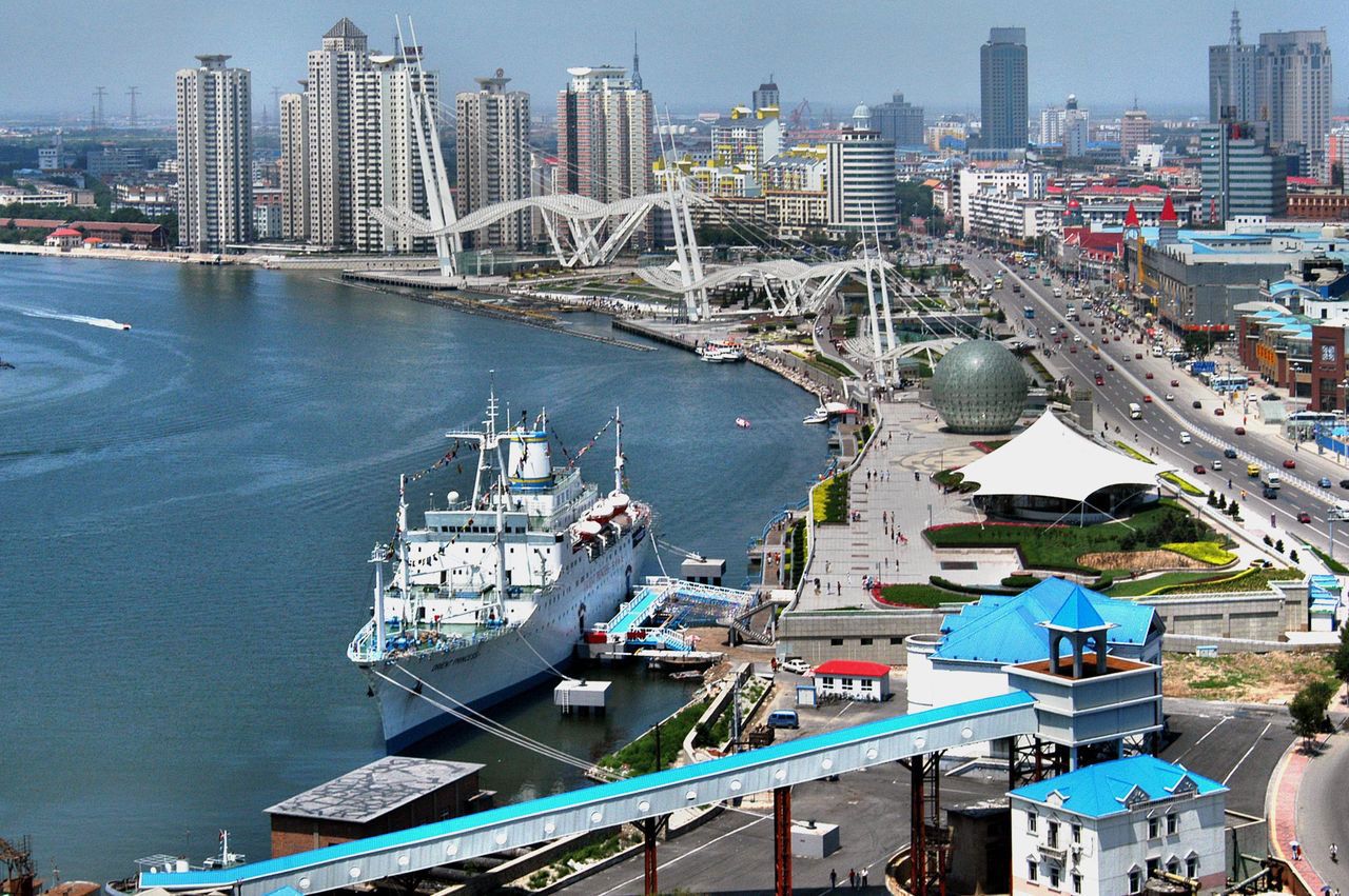


Tanggu (chin. 塘沽区, Tánggū Qū) ist ein chinesischer Stadtbezirk, der zum Verwaltungsgebiet der regierungsunmittelbaren Stadt Tianjin gehört. Er befindet sich im Osten von Tianjin an der Mündung des Hai He in die Bohai-Bucht des Bohai-Meeres. Tanggu hat eine Fläche von 758,9 km² und zählt ca. 488.300 Einwohner (2002).
Tanggu ist der Haupthafen der Region von und um Beijing, der sich von Tianjin hierher direkt an die Küste verlagert hat.
Im Stadtbezirk Tanggu befindet sich die Taku-Forts, welche auf der Denkmalliste der Volksrepublik China stehen.
 Cataluña


 World Heritage
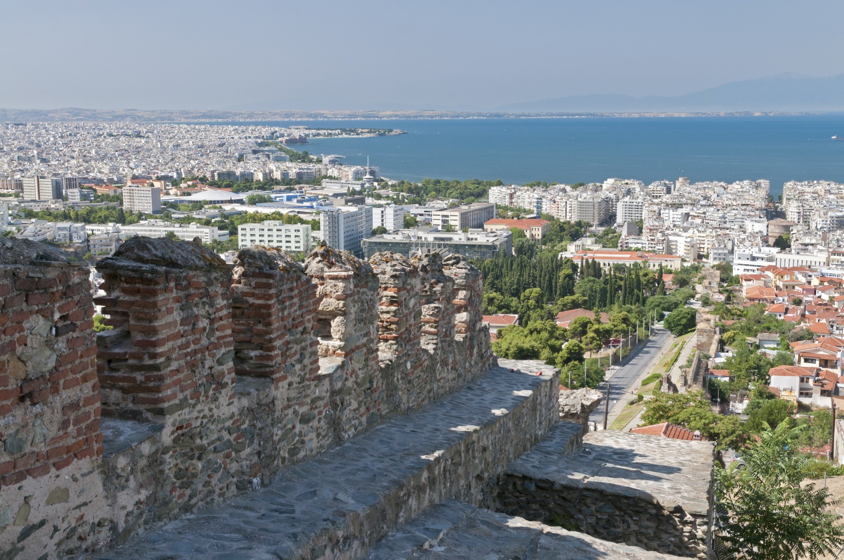
塞萨洛尼基[1](希腊语:Θεσσαλονίκη,罗马化:Thessaloníki,[θesaloˈnici] (ⓘ)),又译作萨洛尼卡、塞萨洛尼卡、萨罗尼加、第撒隆尼基[2][3],旧译作帖撒罗尼迦(按古希腊语发音),是希腊第二大城市,也是希腊北部最大的城市,希腊中马其顿大区和塞萨洛尼基专区的首府。根据2021年官方人口统计,塞萨洛尼卡大都会地区总人口有1,092,919人。
塞萨洛尼基是希腊第二大经济、文化中心,以及东南欧主要的交通枢纽。它的商港对于希腊和东南欧腹地都非常重要。该市拥有2所国立大学,学生人数居希腊首位。作为文化中心,它以拥有大量的拜占庭建筑杰作以及一些重要的奥斯曼帝国、犹太人建筑而知名。该市以每年9月初在此举行的国际贸易博览会知名,希腊总理每年会在此发布下一年政府的计划。塞萨洛尼基还以东南欧最重要的文化活动──塞萨洛尼基国际电影节而闻名,吸引了许多国际名人。
Thessaloniki (griechisch Θεσσαλονίκη (f. sg.) [θɛsalɔˈnikʲi], kurz auch Saloniki Σαλονίκη, Ladino Salonika oder türkisch Selânik, in südslawischen Sprachen Solun (Солун); im biblischen Zusammenhang verwendeter deutscher Name Thessalonich) ist mit rund 326.000 Einwohnern die zweitgrößte Stadt Griechenlands, Hauptstadt der Verwaltungsregion Zentralmakedonien und wirtschaftliches und kulturelles Zentrum der gesamten griechischen Region Makedonien. Zu Jahresanfang 2022 betrug die Einwohnerzahl des engeren Ballungsraums Thessaloniki unter Einschluss der unmittelbar angrenzenden Städte und Gemeinden etwa 814.000 Menschen.
Die Stadt liegt an den nordwestlichen Ausläufern des 1201 Meter hohen Chortiatis und grenzt an den Thermaischen Golf. Sie ist eine bedeutende moderne Universitäts-, Messe-, Kultur-, Industrie- und Hafenstadt im Schnittpunkt wichtiger jahrtausendealter nordsüdlicher und westöstlicher Verkehrswege (Via Egnatia). Als Schutzpatron der Stadt gilt der Heilige Demetrios, dem auch eine große frühchristliche Basilika geweiht ist. Das Wahrzeichen Thessalonikis ist der von dem osmanischen Architekten Sinan gebaute Lefkós Pýrgos (Λευκός Πύργος ‚weißer Turm‘).
Die frühchristlichen und byzantinischen Kirchen der bereits im Neuen Testament erwähnten Stadt (der 1. und 2. Brief des Paulus an die Thessalonicher sind an die Gemeinde in Saloniki gerichtet) wurden 1988 in die Liste des Weltkulturerbes der UNESCO aufgenommen. 1997 war Thessaloniki Europäische Kulturhauptstadt.


 Financial
 M 1500 - 2000 AD
Financial
***Global Financial Center
M 1500 - 2000 AD
Financial
***Global Financial Center
 Geography
*World's Most Livable Cities
Geography
Geography
*World's Most Livable Cities
 History
N 2000 - 2100 AD
History
M 1500 - 2000 AD
History
N 2000 - 2100 AD
History
M 1500 - 2000 AD
 International cities
***Global Urban Economic Competitiveness
Japan
Kantō
Olympic Summer Games
1964 Summer Olympics
2020 Summer Olympics
Important port
International cities
***Global Urban Economic Competitiveness
Japan
Kantō
Olympic Summer Games
1964 Summer Olympics
2020 Summer Olympics
Important port

东京(日语:東京/とうきょう Tōkyō)是位于日本关东地方的都市,狭义上指东京都、或东京都区部(即东京市区),亦可泛指东京都及周边卫星都市群相连而成的“首都圈”(东京都会区)。目前(2017年8月)东京都区部人口数达946万,首都圈的人口数则达3千6百万,是目前全球规模最大的都会区[1],亦为亚洲最重要的世界级城市。东京是传统上的全球四大世界级城市[2]之一,在2016年GDP达9472.7亿美元,超越纽约(9006.8亿)成为全球第一,同时全球城市指数排名中排名第三。
东京古称江户,自德川幕府时代以来开始成为日本主要都市之一,明治维新时期改为现名后,更发展为日本政治、经济、文化、交通等众多领域的枢纽中心。经过二战后的继续发展,东京不仅成为世界商业金融、流行文化与时尚重镇,亦为世界经济发展度与富裕程度最高的都市之一。此外,东京还有目前全球最复杂、最密集的城市轨道交通系统,其中单就计算东京的地铁系统管辖区段每日平均运量达880万人次,繁忙程度居全球地铁第三位(如含地铁直通运转路线、私铁通勤路线及JR东日本通勤路线,则每日平均运量位居世界城市轨道交通运输系统第一位)。
在正式的行政区划定义上,东京仅限于东京都,与道、府、县同为日本的一级行政区,辖区包含东京都区部、多摩地方与伊豆群岛、小笠原群岛等离岛;其中,东京都区部为日本中央政府所在地。东京都同时也囊括了日本最南端(冲之鸟礁)和最东端(南鸟岛)等地理极点,拥有日本各都道府县中最多的人口数,同时也是日本人口密度最高的都道府县。
Tokio (auch Tokyo, japanisch 東京 Tōkyō  [to̞ːkjo̞ː]) ist eine Weltstadt[3] in der Kantō-Region im Osten der japanischen Hauptinsel Honshū. Mit 9.508.776 Einwohnern ist sie nicht nur die bevölkerungsreichste Metropole des Landes, sondern als Sitz der japanischen Regierung und des Tennō auch die Hauptstadt Japans. Sie umfasst die 23 Bezirke auf dem Gebiet der 1943 als Verwaltungseinheit abgeschafften Stadt Tokio und ist damit keine eigene Gebietskörperschaft mehr; stattdessen bilden die Bezirke zusammen mit den Städten und Gemeinden der westlich gelegenen Tama-Region und den südlichen Izu- und Ogasawara-Inseln die Präfektur Tokio. Diese bildet wiederum das Zentrum der Metropolregion Tokio-Yokohama, in der mehr als 37 Millionen Menschen leben (Stand 2014), was die Region zum größten Ballungsraum der Welt macht.
Die Stadtgeschichte beginnt im Jahr 1446, als Ōta Dōkan in einem Sumpfgebiet am Nordufer der heutigen Bucht von Tokio mit dem Bau der Burg Edo begann, umgeben von einigen Fischerdörfern. 1590 ging diese Burg an Tokugawa Ieyasu, der hier nach seinem Sieg in der Schlacht von Sekigahara sein neues Shōgunat und damit die Edo-Zeit begründete. Edo wurde neben Kyōto zum politischen und kulturellen Zentrum des Landes. Mit der Meiji-Restauration 1868 wurde das Shōgunat abgeschafft und der Sitz des Tennō nach Edo verlegt, die Burg wurde zum Kaiserpalast und Edo bekam seinen neuen Namen Tokio, der „Östliche Hauptstadt“ bedeutet. Von da an wuchs auch die Bevölkerung der Stadt, die bereits um 1910 mit rund zwei Millionen Einwohnern zu den größten der Welt zählte. Im Zweiten Weltkrieg war Tokio zahlreichen Luftangriffen durch die USA ausgesetzt, bei denen rund die Hälfte der Stadtfläche zerstört wurde. Nach dem Ende der amerikanischen Besatzungszeit folgte ein rasanter wirtschaftlicher Aufschwung, einhergehend mit einem erneuten Bevölkerungszuwachs.
Tokio ist heute das Industrie-, Handels-, Bildungs- und Kulturzentrum Japans mit zahlreichen Universitäten, Hochschulen, Forschungsinstituten, Theatern und Museen. Mit den Flughäfen Narita und Haneda und als Ausgangspunkt der meisten Shinkansen-Linien ist es auch das Verkehrszentrum des Landes. Der Finanzplatz Tokio ist nicht nur der größte Japans, sondern zählt neben London, New York und Hongkong auch zu den fünf größten der Welt. Zudem weist die Stadt ein hohes Preisniveau auf und lag in einer Studie 2014 auf Platz 9 der teuersten Städte weltweit.[4][5] Neben modernen Sehenswürdigkeiten wie dem Tokyo Tower oder Tokyo Skytree bietet sie auch historische Anlagen wie die Kaiserlichen Gärten in Chiyoda, den Ueno-Park oder den Asakusa-Kannon-Tempel. In den vergangenen Jahren wurde Tokio zu einem zunehmend beliebten Tourismusziel und befindet sich mit jährlich bis zu acht Millionen Besuchern aus dem Ausland unter den 20 meistbesuchten Städten.[6] In einer Rangliste der Städte nach ihrer Lebensqualität belegte Tokio im Jahre 2018 den 50. Platz unter 231 untersuchten Städten weltweit.[7]
東京(とうきょう、英: Tokyo)は、日本の関東平野中央部に位置し、東京湾に面する都市。日本の首都である[1][注 1]。現在、その域内には23特別区・26市・5町・8村の基礎自治体がある[2]。
日本における政治・経済・文化の中心である。政治面では、日本政府が本拠地としている。立法府である国会の議事堂、司法府の頂点である最高裁判所、行政府の長である内閣総理大臣の官邸、中央省庁街(「霞が関」)などは、いずれも東京の中心部である東京23区にある。経済面では、日本の株式上場企業の本社のほとんどが東京に集中し、(東京圏では)購買力平価(PPP)を基にしても東京都市圏のGDPは1兆5369億ドル(2014年)であり[3]、世界的な経済都市であり、大消費地でもある。文化面では、たとえば現在では(東京都内に)千数百におよぶ劇場・ホール・ライブハウス類があり[4]多数のアーティストたちが活動する場であり、ポップカルチャーなどの新しい文化の発信地でもあり、ミシュランガイドの星つきの飲食店の数は世界最多で[5]食文化が華開いている場所でもある。
東京には、日本国内からだけでなく近隣の様々な国や世界各国から外国人が観光に訪れるようになった他、東京に移住した外国人が移民街を形成している。関東大震災や東京大空襲で焼け野原となったが、戦後の発展により現在は世界最大級のメトロポリス・世界都市となっている。東京は明治期にも課題が山積みの都市であったが(#明治維新後の課題と都市政策を参照)、現在もさまざまな課題を抱えている都市である(#近年の東京が都市としてかかえる課題を参照)。 東京都(とうきょうと、英: Tokyo Metropolis)は、日本の首都[注 1]。関東地方に位置する広域地方公共団体(都道府県)のひとつ。都庁所在地は新宿区[注 2]。最大の都市は世田谷区[注 3]。 管轄する領域は東京都区部(東京23区)、多摩地域(26市[注 4]と西多摩郡3町1村)および東京都島嶼部(大島、三宅、八丈、小笠原)の4支庁(2町7村)からなっている。東京都区部(東京23区)は、一つの都市として「東京」とも呼ばれる。沖ノ鳥島、南鳥島を含む小笠原諸島を含むため、日本最南端および最東端に位置する都道府県でもある。都公認の「東京都」の英語表記はTokyo Metropolis(Tokyo Met.)。他には Tokyo Prefecture と Tokyo Metropolitan Prefecture がある。
Tokyo (東京 Tōkyō, /ˈtoʊkioʊ/;[7] Japanese: [toːkʲoː] ( listen)), officially Tokyo Metropolis (東京都 Tōkyō-to), is one of the 47 prefectures of Japan and has been the capital since 1869.[8][9] The Greater Tokyo Area is the most populous metropolitan area in the world.[10] It is the seat of the Emperor of Japan, the Japanese government and the National Diet. Tokyo is in the Kantō region on the southeastern side of the main island Honshu and includes the Izu Islands and Ogasawara Islands.[11] Tokyo was formerly named Edo when Shōgun Tokugawa Ieyasu made the city as his headquarters in 1603. It became the capital after Emperor Meiji moved his seat to the city from Kyoto in 1868; at that time Edo was renamed Tokyo. Tokyo Metropolis was formed in 1943 from the merger of the former Tokyo Prefecture (東京府 Tōkyō-fu) and the city of Tokyo (東京市 Tōkyō-shi).
Tokyo has 39 million residents, 50% more people than any other urban area, with a $2.5 trillion economy larger than that of any other city; if it were a country, Tokyo would be the 8th largest economy in the world. Tokyo is often referred to as a city, but is officially known and governed as a "metropolitan prefecture", which differs from and combines elements of a city and a prefecture, a characteristic unique to Tokyo. The Tokyo Metropolitan Government administers the 23 Special Wards of Tokyo (each governed as an individual city), which cover the area that was the city of Tokyo before it merged and became the metropolitan prefecture in 1943, the 30 municipalities in the western part of the prefecture, and the two outlying island chains. The population of the special wards is over 9 million people, with the total population of the prefecture exceeding 13 million. The prefecture is part of the world's most populous metropolitan area with upwards of 37.8 million people and the world's largest urban agglomeration economy. In 2011, the city hosted 51 of the Fortune Global 500 companies, the highest number of any city in the world at that time.[12] Tokyo ranked third (twice) in the International Financial Centres Development Index. The city is also home to various television networks such as Fuji TV, Tokyo MX, TV Tokyo, TV Asahi, Nippon Television, NHK and the Tokyo Broadcasting System.
Tokyo is ranked first in the Global Economic Power Index and third in the Global Cities Index. The city is considered an alpha+ world city – as listed by the GaWC's 2008 inventory[13] – and in 2014, Tokyo was ranked first in the "Best overall experience" category of TripAdvisor's World City Survey (the city also ranked first in the following categories: "helpfulness of locals", "nightlife", "shopping", "local public transportation" and "cleanliness of streets").[14] In 2015, Tokyo was ranked as the 11th most expensive city for expatriates, according to the Mercer consulting firm,[15] and also the world's 11th most expensive city, according to the Economist Intelligence Unit's cost-of-living survey.[16] In 2015, Tokyo was named the Most Liveable City in the world by the magazine Monocle.[17] The Michelin Guide has awarded Tokyo by far the most Michelin stars of any city in the world.[18][19] Tokyo was ranked first out of all sixty cities in the 2017 Safe Cities Index.[20] The QS Best Student Cities ranked Tokyo as the 3rd-best city in the world to be a university student in 2016[21] and 2nd in 2018.[22] Tokyo hosted the 1964 Summer Olympics, the 1979 G-7 summit, the 1986 G-7 summit, and the 1993 G-7 summit, and will host the 2019 Rugby World Cup, the 2020 Summer Olympics and the 2020 Summer Paralympics.
Tokyo (東京(とうきょう), Tōkyō?, littéralement « Capitale de l'est »), anciennement Edo (江戸(えど)?), officiellement la préfecture métropolitaine de Tokyo (東京都(とうきょうと), Tōkyō-to?), est la capitale actuelle du Japon. Elle est la plus peuplée des préfectures du Japon, avec plus de 13 831 421 habitants intra-muros en 2018 et 42 794 714 dans l'agglomération2, et forme l'aire urbaine la plus peuplée au monde. Située sur la côte est de l'île principale de l'archipel japonais, Honshū, Tokyo est l'une des quarante-sept préfectures du Japon. Principal centre politique de l'archipel depuis le XVIIe siècle, la ville accueille la plupart des institutions du pays : la résidence de l'empereur du Japon, du Premier ministre, le siège de la Diète (le parlement japonais), du Cabinet, les ministères qui le constituent ainsi que toutes les ambassades étrangères.
À l'origine, Tokyo était un petit village de pêcheurs nommé Edo (« l'estuaire »). Fortifié au XVe siècle, Edo devient la base militaire du shogun Tokugawa Ieyasu à la fin du XVIe siècle, puis la capitale de son gouvernement. Durant l’époque d'Edo (1603-1868), la ville se développe et devient l'une des plus peuplées au monde à la fin du XVIIIe siècle, avec une population de près d'un million d'habitants. Avec la restauration de l'Empire en 1868, elle est confortée dans son rôle de cœur politique du Japon : le château d'Edo devient la résidence de l'empereur Meiji (Kōkyo), et la ville acquiert son nom actuel par opposition à Kyoto, l'ancienne capitale. Elle est ravagée en 1923 par un séisme de magnitude 7,9 qui fait plus de 100 000 morts. Durant la Seconde Guerre mondiale, elle est détruite pour moitié par des bombardements aériens américains, mais est rapidement reconstruite. Dans la seconde moitié du XXe siècle, Tokyo devient une métropole de rang mondial grâce à un fort développement industriel — notamment dans l'électronique —, et voit sa population multipliée par dix en cinquante ans.
Principal centre économique et financier du Japon, Tokyo est l'une des principales places financières asiatiques et mondiales. Elle est la première ville mondiale en termes de produits urbains bruts. Le dynamique arrondissement de Shinjuku comporte de nombreux gratte-ciels, dont la mairie de la ville, et plusieurs grands magasins du Japon. Minato-ku accueille les sièges sociaux de nombreuses entreprises japonaises et étrangères, ainsi qu'une cinquantaine d'ambassades. Chiyoda concentre quant à lui les institutions politiques japonaises. Enfin, Shibuya est réputé être l'un des quartiers les plus animés de la ville, grâce à la présence de grands centres commerciaux comme le 109. Malgré la modernité de son architecture, dont témoigne la tour Tokyo Skytree, de nombreux sanctuaires shinto et temples bouddhistes ont été préservés ou reconstruits après les bombardements, comme le Sensō-ji, le sanctuaire Yasukuni, le Zōjō-ji ou les portes Hōzōmon.
Située au fond de la baie de Tokyo, la commune de Tokyo dispose d'un statut administratif particulier parmi les préfectures du Japon, la ville de Tokyo ayant été supprimée en tant qu'entité politique ou administrative en 1943. L'agglomération de Tokyo, qui s'étend bien au-delà des limites de la préfecture, s'étend sur une large frange de la baie de Tokyo ainsi que sur la région du Kantō. Elle constitue en outre un des pôles de la mégalopole japonaise, avec notamment Ōsaka et Nagoya. La préfecture a organisé les Jeux olympiques d'été de 1964, et les accueillera à nouveau en 2020.
Tokio (東京都 Tōkyō-to?, lit. ‘capital del este’; pronunciación japonesa: [toːkʲoː] (?·i)) es la capital de facto6 de Japón, localizada en el centro-este de la isla de Honshu, concretamente en la región de Kanto. En conjunto forma una de las 47 prefecturas de Japón, aunque su denominación oficial es metrópolis o capital (都 -to). La ciudad es el centro de la política, economía, educación, comunicación y cultura popular del país. Cuenta también con la mayor concentración de sedes corporativas, instituciones financieras, universidades y colegios, museos, teatros, y establecimientos comerciales y de entretenimiento de todo Japón.
Con una población que supera los 13 millones de habitantes, se subdivide en 23 barrios (区 -ku); 26 ciudades (市 -shi); un distrito (郡 -gun) subdividido en tres pueblos (町 -chō o -machi) y una villa (村 -son o -mura); y cuatro subprefecturas (支庁 -shichō) subdivididas en dos pueblos y siete villas, que representan a varias pequeñas islas al sur de Honshu que se extienden más allá de 1800 km de Shinjuku, capital de la metrópoli y sede de la gobernación. El centro de Tokio, con sus 23 barrios, ocupa un tercio de la metrópoli, con una población cercana a los 13,23 millones de habitantes; esta área es lo que se conoce internacionalmente como la ciudad de Tokio. En su área metropolitana viven más de 37 millones de habitantes, lo que la convierte en la mayor aglomeración urbana del mundo.
A pesar de que Tokyo es la romanización más común del nombre en japonés, el nombre de la ciudad es Tokio en español y otros idiomas —entre ellos el alemán y el neerlandés—. En inglés y otros idiomas se escribe Tokyo, aunque antiguamente también se escribía Tokio. En el pasado, la ciudad se denominaba como Tokei, Edo o Yedo. El gentilicio de Tokio es tokiota.
Tokio fue sede de los Juegos Olímpicos de 1964 y será sede de los Juegos Olímpicos de 2020.7
То́кио (яп. 東京 То:кё: (инф.), «Восточная столица»[4][5]) — столица Японии, её административный, финансовый, промышленный и политический центр. Крупнейшая городская экономика мира[6]. Расположен в юго-восточной части острова Хонсю, на равнине Канто в бухте Токийского залива Тихого океана.
Помимо столицы, Токио также является одной из сорока семи префектур страны. Площадь префектуры составляет 2188,67 км²[7], население — 13 742 906 человек (1 октября 2017)[8], плотность населения — 6279,11 чел./км². По состоянию на 1 мая 2020 года население Токио составляло 14 002 973 человека, что делает Токио префектурой с самым большим населением в Японии.[9] Большой Токио является городской территорией с самым большим населением в мире, с населением по состоянию на 2016 год в 38 140 000 человек.[2]
Токийский столичный округ — административная единица Японии, включающая в себя специальные районы Токио, область Тама и островные территории Токийского столичного округа (острова Идзу и Огасавара).
 FIFA Fussball-Weltmeisterschaft 2026
 Ontario-ON


多伦多[注 1](英语:Toronto)是加拿大安大略省首府,也是加拿大最大的城市,坐落在安大略湖西北岸的南安大略地区。根据2021年的加拿大人口普查,多伦多市人口达2,794,356人,为加拿大最大城市。多伦多市是大多伦多地区的核心地区,也是安大略省南部人口稠密区(称作“金马蹄地区”)的一部分。[9][10][11]都会区有6,202,225名居民,[12]而覆盖范围较广的大多伦多地区则有9,765,188名居民。[10]作为加拿大的经济中心,多伦多是一个世界级城市,[13]也是世界上最大的金融中心之一。[14][15]多伦多在经济上的领先地位在于金融、商业服务、电信、航太、交通运输、媒体、艺术、电影、电视制作、出版、软件、医药研究、教育、旅游、体育等产业。[16][17]多伦多证券交易所是世界第七大交易所,总部设于市内,有多数加拿大公司在这里上市。
多伦多的国际性人口[18]体现出它是前往加拿大移民的重要落脚点。[19]而市内49%的人口是在加拿大以外诞生[20],也造就多伦多成为世上种族最多样化的城市之一。目前多伦多的低犯罪率、洁净的环境、高生活水准、以及对多样文化的包容性,令该市被多个经济学智囊团列为世界上最宜居的城市之一。[21][22]另一方面,多伦多于2006年被列为加拿大生活成本最高的城市。
多伦多(英语/法语:Toronto),是北美洲国家加拿大安大略省首府,加拿大的最大城市。
多伦多坐落在安大略湖西北岸的南安大略地区。根据2012年七月的加拿大人口普查,多伦市人口达2,790,060,为加拿大最大城市。多伦多市是大多伦多地区的心脏地区,也是安大略省南部人口稠密区(称作“金马蹄地区”)的一部分。[1][2][3]城市区有5,132,794名居民。[4]在2011年人口普查中,多伦多人口普查区有5,583,064名居民,而覆盖范围较广的大多伦多地区则有6,054,191名居民。[2]
作为加拿大的经济中心,多伦多是一个世界级城市,[5]也是世界上最大的金融中心之一。[6][7] 多伦多在经济上的领先地位在于金融、商业服务、电信、航太、交通运输、媒体、艺术、电影、电视制作、出版、软件、医药研究、教育、旅游、体育等产业。[8][9]多伦多证券交易所是世界第七大交易所,总部设于市内,有多数加拿大公司在这里上市。
多伦多的国际性人口[10] 体现出它是前往加拿大移民的重要落脚点。[11]而市内49%的人口是在加拿大以外诞生[12],也造就多伦多成为世上种族最多样化的城市之一。目前多伦多的低犯罪率、洁净的环境、高生活水准、以及对多样文化的包容性,令该市被多个经济学智囊团列为世界上最宜居的城市之一。[13][14]另一方面,多伦多于2006年被列为加拿大生活成本最高的城市。[15]
大约1/3的加拿大人居住在距多伦多两小时车程的郊区。加拿大大约1/6的就业机会在该市。
多伦多当地的华侨及华裔人口多达四十万,相当于加拿大全国约百分之一的人口,该城市也是加拿大华人最多的城市。除此之外也有大量世界各地的移民,加拿大安大略省多伦多市的人口统计资料使多伦多成为世界上最多元文化和多种族的城市之一。2016年,该市居民的51.5%属于明显的少数族裔,而2011年这一比例为49.1%,和1981年为13.6%。多伦多还建立了多个社区,例如唐人街,意大利的Corso,小意大利,小印度,希腊城,韩国城,小牙买加,小葡萄牙和朗塞瓦勒,以庆祝该市的多元文化主义的成功。
Toronto (englische Aussprache [təˈɹɒn(t)oʊ̯]; regional auch [təˈɹɒnə] oder [ˈtɹɒnoʊ̯]) ist mit 2,6 Millionen Einwohnern[2] die größte Stadt Kanadas und die Hauptstadt der Provinz Ontario. Sie liegt im Golden Horseshoe (Goldenes Hufeisen), einer Region mit über 8,1 Millionen Einwohnern, die sich halbkreisförmig um das westliche Ende des Ontariosees bis zu den Niagarafällen erstreckt. Rund ein Drittel der Bevölkerungszunahme des ganzen Landes lebte in den letzten Jahren in diesem Großraum. Die Einwohnerzahl der Metropolregion (Census Metropolitan Area) stieg von 4,1 Millionen im Jahr 1992 auf 5,6 Millionen im Jahr 2011.[3] Die Greater Toronto Area hatte 2010 über 6,2 Millionen Einwohner.[4]
Die Stadt liegt am nordwestlichen Ufer des Ontariosees, dem mit 18.960 km² Fläche[5] kleinsten der fünf Großen Seen. Durch die Eingemeindung einer Reihe von Vorstädten, die bereits mit Toronto verschmolzen waren (Etobicoke, Scarborough, York, East York und North York), wurde Toronto Ende der 1990er Jahre mehrfach vergrößert. Das Zentrum mit dem Einkaufs- und Bankendistrikt befindet sich in der Nähe des Sees. Die Haupteinkaufsstraße ist die Yonge Street. Toronto ist seit ungefähr den 1970er Jahren, nachdem Montreal über Jahrzehnte hinweg diese Rolle zugefallen war, Kanadas Wirtschaftszentrum und weltweit einer der führenden Finanzplätze.
トロント(英語: Toronto、標準音:[təˈɹɒntoʊ]、現地音:[ˈtɹɒnoʊ, təˈɹɒnoʊ])は、カナダのオンタリオ州の州都であり、同国最大の都市である。オンタリオ湖岸の北西に位置し、2016年の統計で人口273万人[1]。
国際影響力の強い世界都市であり、2016年の都市圏人口は624万人[2]。またヒューロン語で「集まる場所」という意味がある。
オンタリオ湖西岸を囲むゴールデン・ホースシュー(Golden Horseshoe)と呼ばれる都市化された地域の人口はおよそ924万人とされ、カナダ随一の金融センターとしてその中心を成している。1834年までの旧名はヨーク(Town of York)。
Toronto is the provincial capital of Ontario and the most populous city in Canada, with an estimated population of 2,956,024 (2018) and an estimated population of 6,341,935 in the Toronto Region (2018.)[14] Located on the shores of the western end of Lake Ontario, Toronto is also the anchor of the Golden Horseshoe, an urban agglomeration of 9,245,438 (2016)[15] that accounts for a significant portion of Canada's economic activity and more than 20% of Canada's population. Toronto is an international centre of business, finance, arts, and culture. Its large population of immigrants from around the globe has also made Toronto one of the most multicultural and cosmopolitan cities in the world.[16][17][18]
People have travelled through and inhabited the Toronto area, located on a broad sloping plateau interspersed with rivers, deep ravines, and urban forest, for more than 10,000 years.[19] After the broadly disputed Toronto Purchase, when the Mississauga surrendered the area to the British Crown,[20] the British established the town of York in 1793 and later designated it as the capital of Upper Canada.[21] During the War of 1812, the town was the site of the Battle of York and suffered heavy damage by American troops.[22] York was renamed and incorporated in 1834 as the city of Toronto. It was designated as the capital of the province of Ontario in 1867 during Canadian Confederation.[23] The city proper has since expanded past its original borders through both annexation and amalgamation to its current area of 630.2 km2 (243.3 sq mi).
The diverse population of Toronto reflects its current and historical role as an important destination for immigrants to Canada.[24][25] More than 50 percent of residents belong to a visible minority population group,[26] and over 200 distinct ethnic origins are represented among its inhabitants.[27] While the majority of Torontonians speak English as their primary language, over 160 languages are spoken in the city.[28]
Toronto is a prominent centre for music,[29] theatre,[30] motion picture production,[31] and television production,[32] and is home to the headquarters of Canada's major national broadcast networks and media outlets.[33] Its varied cultural institutions,[34] which include numerous museums and galleries, festivals and public events, entertainment districts, national historic sites, and sports activities,[35] attract over 43 million tourists each year.[36][37] Toronto is known for its many skyscrapers and high-rise buildings,[38] in particular the tallest free-standing structure in the Western Hemisphere, the CN Tower.[39]
The city is home to the Toronto Stock Exchange, the headquarters of Canada's five largest banks,[40] and the headquarters of many large Canadian and multinational corporations.[41] Its economy is highly diversified with strengths in technology, design, financial services, life sciences, education, arts, fashion, aerospace, environmental innovation, food services, and tourism.[42][43][44]
Toronto (/tɔ.ʁɔ̃.to/1 ; en anglais : /təˈɹɒntoʊ̯/2 Écouter voire localement /təˈɹɒnə/ ou /ˈtɹɒnoʊ̯/ Écouter) est la plus peuplée des villes du Canada et la capitale de la province de l'Ontario. Elle se situe dans le Sud-Est du Canada, sur la rive nord-ouest du lac Ontario. Selon le recensement de 2016, Toronto compte plus de 2,7 millions d'habitants, faisant d'elle la quatrième ville la plus peuplée en Amérique du Nord. Son aire métropolitaine compte 5,9 millions d'habitants, et la mégalopole du Golden Horseshoe, dont elle est le cœur, plus de 8,7 millions d'habitants en 2011, soit le quart de la population canadienne. Ville mondiale, Toronto est le centre bancaire, financier, commercial et artistique du Canada anglophone, et l'une des villes les plus multiculturelles et cosmopolites au monde.
La région de Toronto, située sur un vaste plateau en pente jalonné de rivières, de ravins et de forêts, est habitée depuis plus de 10 000 ans. Après la brève installation d'un fort par les Français puis l’achat contesté de la région au peuple Mississauga par la Couronne britannique, les colons anglais fondent en 1793 la ville d'York, qui devient la capitale du Haut-Canada. Pendant la guerre de 1812, la ville est le théâtre de la bataille d'York et subit de lourds dégâts par les troupes américaines. York est renommée Toronto en 1834. Elle est désignée capitale de la province de l'Ontario en 1867 par la Confédération canadienne. La ville s'est depuis étendue au-delà de ses frontières d'origine, à la suite de plusieurs fusions, jusqu'à atteindre la superficie actuelle de 630,2 km2.
La population particulièrement cosmopolite de Toronto reflète son rôle historique de destination des immigrants au Canada. Plus de 50 % des résidents appartiennent à un groupe de minorités visibles et plus de 200 origines ethniques distinctes sont représentées parmi ses habitants. Bien que la majorité des Torontois parlent l'anglais principalement, plus de 160 langues sont parlées dans la ville.
Toronto est devenu un important centre de musique, théâtre, de production cinématographique et télévisuelle. Elle abrite le siège des principaux réseaux de diffusion et des médias nationaux du Canada. Ses institutions culturelles variées, qui comprennent de nombreux musées et galeries d'art, des festivals et événements publics, des quartiers de divertissement, des lieux historiques nationaux et des activités sportives, attirent plus de 25 millions de touristes chaque année. Toronto est connue pour ses nombreux gratte-ciel, en particulier la plus haute structure autoportante de l' hémisphère occidental, la tour CN.
La ville abrite la Bourse de Toronto, le siège des cinq plus grandes banques du Canada et de nombreuses autres grandes sociétés canadiennes et multinationales, de tous les secteurs économiques. Elle abrite aussi de nombreux établissements d'enseignement supérieur réputés, dont l'université de Toronto qui figure parmi les plus réputées au monde.
Toronto apparaît régulièrement dans les classements des meilleures villes en termes de qualité de vie, malgré un coût de la vie important. Ses habitants s'appellent les Torontois.
Toronto (IPA: [təˈɹɒntoʊ̯]; pronuncia locale: [ˈtrɒnoʊ] oppure [təˈɹɒnə], ascolta[?·info]) è una città dell'estremo Sud-Est del Canada, capoluogo della provincia dell'Ontario e centro più popoloso del Canada con i suoi 3 120 668 abitanti[1] (5 928 040 nell'area metropolitana[2]).
Motore economico del Canada, Toronto è, assieme a Montréal, la città del paese nordamericano più conosciuta nel mondo, seguita da Ottawa. Caratteristica della città è quella di essere una delle più multiculturali nel mondo, con circa il 36% degli abitanti di origine non canadese. Per dare un'idea di ciò basti pensare che il 911 (numero telefonico di emergenza) di Toronto è attrezzato per rispondere in oltre 150 lingue[3]. La seconda più grande comunità, superata da qualche anno da quella cinese, è costituita dagli italiani che hanno dato un enorme contributo allo sviluppo di questo paese. Si stima che le persone di origine italiana residenti a Toronto siano superiori a 500 000. Il primo quartiere dove si insediarono gli italiani fu quello di College, successivamente si spostarono a Saint Clair denominata col nome aggiuntivo di Corso Italia[4] dal 1988.
Toronto è suddivisa in 240 quartieri all'interno dei suoi confini, raggruppati in sei distretti (Old Toronto, East York, Etobicoke, Scarborough, North York e York (dove si trova anche il quartiere di Weston). Nella parte centrale di Toronto (Downtown Toronto) c'è una città sotterranea, chiamata PATH (in inglese: il sentiero o il percorso), costituita da una rete di collegamenti che mettono in collegamento i grattacieli della città. Il percorso è lungo più di 30 km. Secondo il Guinness dei primati, con i suoi 371600 m² di estensione, il PATH è più esteso centro commerciale sotterraneo del mondo.[5]
I residenti considerano questi 27 km di strade sotterranee come parte della città stessa, come se la città iniziasse non dal suolo, ma dal piano -3. Venne creata agli inizi degli anni sessanta perché in inverno, spazzata da venti nordici, Toronto è molto fredda in rapporto alla latitudine, mentre sotto ci si può muovere in abiti primaverili, sulle strade superiori, durante straordinarie irruzioni gelide ci possono essere temperature di −25/−30 °C al primo mattino o di sera. Di notte si può scendere un po' più in basso ed in tali casi le massime rimangono spesso a -20 sotto lo zero. Ovviamente il traffico automobilistico convenzionale è bandito nella città sotterranea, gli spostamenti sono previsti a piedi o con mezzi per disabili, ma il path ha numerosi punti di contatto con la viabilità esterna (parcheggi) o, molto più frequentemente, con una fitta rete di stazioni del trasporto pubblico di superficie o sotterraneo (subway).
Per muoversi nella parte sotterranea è molto importante fare riferimento a elementi di identificazione degli incroci (come elementi architettonici, facciate di banche, negozi tipici, ecc.), dato che non sempre il percorso sotterraneo (pedonale) corrisponde a quello (stradale) di superficie; o meglio, se non si è pratici, bisogna usare la mappa. La città sotterranea è completamente attrezzata come una città comune: ci sono banche, uffici postali, locali pubblici, ristoranti, uffici e supermercati. Le maggiori istituzioni (stazioni ferroviarie, aziende pubbliche, aziende commerciali, ecc.) hanno accesso multiplo: di superficie e sotterraneo.
Toronto (pronunciación en inglés: /tʲəˈɹɑntʲoʊ/ (![]() escuchar), localmente /tʲəˈɹɑnoʊ/, /ˈtʲɹɑnoʊ/) es la capital de la provincia de Ontario3 y, con una población de 2 615 060 habs.4 es la ciudad más grande de Canadá,5 además del centro financiero de dicho país.
escuchar), localmente /tʲəˈɹɑnoʊ/, /ˈtʲɹɑnoʊ/) es la capital de la provincia de Ontario3 y, con una población de 2 615 060 habs.4 es la ciudad más grande de Canadá,5 además del centro financiero de dicho país.
Localizada en la orilla noroeste del lago Ontario,6 es la quinta ciudad más grande de Norteamérica.7 Toronto se encuentra en el corazón del Área Metropolitana de Toronto (Greater Toronto Area en inglés y abreviado como GTA), la mayor área metropolitana de Canadá, y es parte de una región densamente poblada en el centro-sur de Ontario conocida como Golden Horseshoe (Herradura Dorada), donde residen ocho millones de habitantes.8910
Al ser la capital económica de Canadá, Toronto es considerada una ciudad global y una de las principales ciudades financieras del mundo.11 Lidera los sectores económicos de finanzas, servicios empresariales, telecomunicaciones, transporte, medios de comunicación, arte, cine, investigación médica, educación, y turismo de Canadá.1213 El Toronto Stock Exchange es la mayor bolsa de valores del país y la séptima del mundo.12
Toronto es famosa por la Torre CN, con 553 metros de altura. La ciudad se considera el centro de la cultura canadiense anglófona y es la anfitriona de muchas celebraciones nacionales.
La población de Toronto es cosmopolita,1415 y es un importante destino para muchos inmigrantes a Canadá.16 Toronto es la mayor ciudad del mundo en porcentaje de residentes no nacidos en el propio país; sobre un 49 % de los habitantes de la ciudad no ha nacido en Canadá.141516 Debido al bajo índice de criminalidad,17 el cuidado medio ambiente y el alto nivel de vida, Toronto, es considerada con asiduidad una de las ciudades mejor habitables del mundo.1819 Además, en 2006 fue clasificada como la ciudad más cara de Canadá.20 Los nacidos en Toronto reciben el gentilicio de torontonianos.21
En enero de 2005, Toronto fue escogida por el gobierno canadiense como una de las capitales culturales de Canadá. Toronto posee una de las mejores calidades de vida de América del Norte, y es considerada por muchos como una de las mejores metrópolis del mundo para vivir.22 Es una de las ciudades más seguras de América —su tasa de criminalidad es menor que la de cualquier gran ciudad del continente, y una de las menores de Canadá.23
En la ciudad vecina de Mississauga está el Aeropuerto Internacional Toronto Pearson. Además, en 'las islas de Toronto' dentro de la ciudad está el Billy Bishop Toronto City Airport, que es más pequeño.
Торо́нто (англ. Toronto [təˈrɒntoʊ], местн. [təˈrɒnoʊ], [ˈtrɒnoʊ], [-nə]) — крупнейший город Канады, административный центр провинции Онтарио. Население — 2 731 571 чел. (2016); вместе с городами Миссиссога, Брамптон, Маркем и другими образует агломерацию Большой Торонто с населением 5928 тыс. жителей.
Торонто является частью «золотой подковы» — густонаселённого региона вокруг западной части озера Онтарио с населением около 7 млн человек. Приблизительно одна треть всего населения Канады живёт в радиусе 500 км от Торонто. Около шестой части всех рабочих мест Канады находятся в пределах городской черты.
Город Торонто известен также как «экономический двигатель» Канады, считается одним из ведущих мегаполисов мира и имеет большой вес как в регионе, так и на государственном и международном уровне. В ежегодном рейтинге Global Liveability Ranking журнала The Economist, оценивающем совокупное качество жизни, Торонто занимает четвёртое место в мире среди 140 городов — участников рейтинга[1].
В Торонто располагается главный офис Всемирного конгресса украинцев. В июне 2010 года в Торонто прошла встреча глав государств и правительств «Большой двадцатки».
К северо-востоку от Торонто в городе Пикеринг находится атомная электростанция АЭС Пикеринг с восемью ядерными реакторами.


Türkmenbaşy (russisch Туркменбашы Turkmenbaschy; bis 1993 Krasnowodsk/russisch Красноводск) ist eine Hafenstadt im Westen Turkmenistans in der Provinz Balkan. Sie ist der Endpunkt der transkaspischen Eisenbahn.
土库曼巴希[1](土库曼语:Türkmenbaşy),1993年前名为克拉斯诺沃茨克(俄语:Красноводск),是土库曼斯坦巴尔坎州最重要的港口城市,位于里海的东岸克拉斯诺沃茨克湾北岸。1999年人口51,000人,以土库曼族和阿塞拜疆族为主。


图尔库(芬兰语:Turku,发音:[ˈturku] (ⓘ);瑞典语:Åbo,发音:[ˈoːbu] (ⓘ),奥布)是芬兰西南部芬兰本部区的城市,为该国第六大城市,也是最古老的城市(在1154年已有记载),人口188,584人(2017年8月底)。
图尔库是芬兰第一个首都(1812年以前),也是第一个教区(成立于1300年,后来成为大主教区),还是芬兰第一所大学(奥布皇家学院,建于1640年)的所在地。
1741年瑞典王国进攻俄罗斯帝国,企图夺回芬兰湾地带,但俄军占领了芬兰全境。1743年,瑞典屈辱求和,俄国迫使之签定《奥布和约》,割让包括维堡在内的芬兰东南部地区。